
Kootenai National Forest
Vast by Nature, Uncrowded by Design
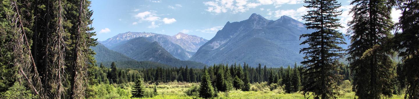
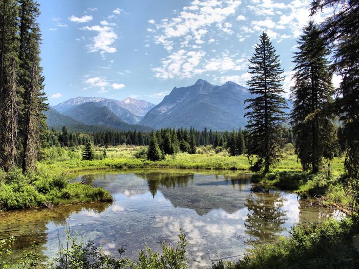
Bordering Canada and nestled in the mountainous terrain of Northwest Montana the Kootenai National Forest hold impressive forests, wildlife and landscapes, including striking cliffs, spires, river canyons and the magnificent peaks of the Cabinet Mountains Wilderness and Whitefish Range. Whether your interest is recreation or local history, the KNF has something for just about everyone. Water, in all forms has played a significant role in shaping recreation with reservoirs, rivers, waterfalls, glacial lakes, and snow providing a variety of year rounds day-use activities. This vast uncrowded landscape has been the lifeblood for many peoples for thousands of years and continues to foster a pioneer spirit passed down through the generations. These ties to the land and history are the foundation for interpretation and education for new and traditional visitors. Whatever the season, the Kootenai National Forest contains 2.2 million acres in which to explore!
Recreation opportunities on the KNF can be viewed as occurring in 7 fairly broad geographic areas, each centered around one or more distinctive features. These areas are the:
- Yaak River Area (Three Rivers Ranger District - the most northwesterly point in Montana)
- Bull Lake Area (Three Rivers Ranger District - western access to the Cabinet Mountains Wilderness)
- Clark Fork River Area (Cabinet Ranger District - situated along the Clark Fork River and the southern end of the Cabinet Mountain Wilderness)
- Libby Area (Libby Ranger District - centered around the Kootenai River)
- Fisher River Area (Libby Ranger District - comprised of the Fisher River drainage and the chain of lakes area)
- Koocanusa Reservoir (Libby & Eureka Ranger District -centered around the reservoir and its major tributaries)
- Tobacco Plains Area (Eureka & Fortine Ranger District - open plains surrounded by rugged mountains)
On our web site you'll find our recreation sites organized by these areas. So, note the area on our forest you'd like to stay or explore and then discover our recreation opportunites. Or, choose an activity and see where on the forest it is offered. Either way, we're sure you'll find exceptional recreation opportunities on the Kootenai National Forest.
RecAreaDirections
Open with Google Map
Misc
| Stay Limit | |
| Reservable | false |
| Keywords | |
| Map Link | |
| Contact Phone | |
| Contact Email |
Permits info
Facilities
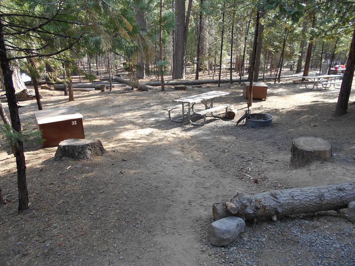
Dorr Skeels Campground Campground
List of CampsitesOverview
Dorr Skeels Campground is located 13 miles south of Troy on Hwy 56. The Dorr Skeels Campground has 8 overnight campsites, including one host site and 2 day use sites with tables and fire rings. Amenities include potable water, vault toilets, swimming area with beach and a fully developed boat ramp with dock. A security gate is closed at 10:00 pm and opened at 07:00 am daily by the camphost.
Recreation
The campground has a boat ramp with dock, a beach area and bouyed off swimming area. There are several day use sites available for guests.
Facilities
The campground has 8 overnight camp sites, including one host site and 2 day use sites, all with tables and fire rings. Most sites offer an average length of 30 feet. Vault toilets, garbage service and drinking water are available during the peak season. The campground campsites are not currently on the reservation system.
Natural Features
At an elevation of 2,344 feet, the campground is nestled among mature pines at the north end of Bull Lake in the Bull Lake Area. The lake spans 1,162 acres. The lake is popular with recreationists as well as fisherman. Many species of fish can be found there including brook trout, bull trout, kokanee, small and large mouth bass, pike, suckers, whitefish and perch.
Nearby Attractions
The campground lies along the western edge of the Cabinet Mountains Wilderness and is just north of an ancient cedar grove, Ross Creek Cedars.
Meadow Peak Lookout (MT) Campground
List of CampsitesOverview
Meadow Peak Lookout sits atop its namesake mountain at an elevation of 6,710 feet in the Kootenai National Forest. The lookout has been used as an observation point for spotting forest fires for over 90 years. On July 13, 1948 J.K. Pomajevic wrote, "hiked up to Meadow Peak on Trail 46, about a 6 mile walk from road to lookout. At this point there is a cabin with a cupola on top. It is connected to Bend Ranger Station by telephone". This phone line would have been approximately 14 miles long.
The first lookout was a cupola cabin built in 1928, the second lookout was built in 1936 it was a 15' L-4 style lookout and the the current lookout was built in 1957 as a 10' L-4 style for $6299. Leonard Sheffield was the contractor and had 3 Forest Service employees to help with the build. The lookout was last staffed in the 1990's and was placed on the National Historic Lookout Register in 2000.
The lookout is typically open from mid-June through late September. High clearance 4 wheel drive vehicles with off-road tires are required. Access to this lookout is along mountain roads with sections of loose sharp rocks and small boulders.
This mountain hideaway offers some amenities, but guests should plan to pack in most of their own supplies. Cell service is available at the lookout.
Recreation
Hikers can find places to explore around the lookout, and the surrounding Libby Area offers more than 400 miles of summer use trails. The lookout offers an ideal vantage point for star gazing on clear nights.
Facilities
Lookouts are rustic in every sense of the word. They are remotely located and lack the conveniences of civilization such as running water, electricity or telephones. Lookouts are usually one room cabins built on top of towers, 40-60 feet from the ground. They are reached by climbing several steep stairs under the single room. They have windows on all four sides, providing a panoramic 360-degree view. These structures are usually very box-like and simply furnished, as the fire spotter used them for work rather than living quarters. Most likely they contain a center table for the alidade (a round instrument on a pedestal that aids in plotting the fire’s exact location on a map), wooden beds, and table and chair placed on an old linoleum floor. Some lookouts include a propane or wood stove. Lookouts are often surrounded by a catwalk, a deck-like addition built around the cabin affording extraordinary, unobstructed views.
Meadow Peak lookout stands 10 feet tall and has a 225 square foot cabin, which is encircled by a catwalk. It sleeps four and comes furnished with two twin beds, both with mattresses. Other amenities include a two-burner propane cooktop (bring your own propane), table and chairs, fire extinguisher, cleaning supplies and some cooking utensils. An outhouse with vault toilet is located near the tower. A campfire ring is located outside, but firewood is not provided. Water and electricity are not available. Guests must bring enough for drinking, cooking and washing. Items such as cookware, bedding, lanterns or flashlights, matches, extra toilet paper, first aid supplies, trash bags, dish soap, towels and an ice chest are not available. Guests are expected to pack out their trash and clean the cabin before leaving.
Natural Features
The lookout is located in the Purcell Range of the Rocky Mountains and offers panoramic views of densely forested peaks, Cabinet Mountains Wilderness, Lower Thompson and McGregor Lakes. Kootenai National Forest supports populations of deer, elk, moose, grizzly and black bears, wolves and mountain lions (bear safety). A variety of smaller mammals and birds can also be found.
REXFORD BENCH Campground
List of CampsitesOverview
Rexford Bench Recreation Area is the most highly developed camp area within the Kootenai National Forest. Rexford Bench Campground has 54 sites, 35 are first come-first serve and 19 can be reserved. Kamloops Terrace has 20 sites and additional overflow parking. A high and low water boat ramp is available. A day use area with swimming beach completes this popular area. It is a popular destination for boating, fishing and swimming on Lake Koocanusa, and hiking in the surrounding forest. Beautiful sandstone formations can be viewed not far from the campground, and osprey and eagles can often be seen fishing in the reservoir.
Recreation
Fishing, boating and swimming are popular activities. Fishing derbies are held several times each year and anglers can expect a catch of kokanee salmon, whitefish and a variety of trout, among others.
A variety of hiking trails begins in the campground, including a relatively short interpretive trail that loops around the campground, and the Hoodoo Trail, that leads to impressive sandstone formations that jut out from an inlet along the lake. The Hoodoos can also be seen via boat. Several paths lead from the campground to the adjacent beach, boat ramp and overflow parking area.
Facilities
The campground offers dozens of accessible, single-family sites for tent and RV camping. Some sites are available on a first-come, first-served basis. A large overflow parking area is available for boat trailers and RVs.
Each site is equipped with a table and campfire ring with grill. Accessible flush toilets and drinking water are provided, but utility hookups are not available. Campground roads and campsite spurs are paved. A campground host is on-site.
Natural Features
The campground is located on an arm of Lake Koocanusa in northwest Montana near the Canadian border. The 46,500-acre reservoir has over 127 miles of shoreline and is formed by 422' Libby Dam on the Kootenai River, which stretches about 90 miles and into Canada. It is a large campground, situated in a ponderosa pine forest at an elevation of 2,470 feet.Osprey often fish around Libby Dam at sunset, making for enjoyable viewing opportunities. Bald eagles can be seen hunting kokanee in the river and lake during the fall. A variety of wildlife also makes its home in the area.
Nearby Attractions
The Kootenai River, below Libby Dam, is a blue ribbon fishery. Guided tours of the dam and powerhouse are offered at the visitor center throughout the summer. Visitors also enjoy driving the 100-mile loop around the reservoir. Several trails, including some that lead to scenic waterfalls, are located along the route.MCGREGOR LAKE CAMPGROUND Campground
List of CampsitesOverview
McGregor Lake Campground is located approximately 53 miles southeast of Libby, Montana, on Highway 2 at the west end of McGregor Lake in the Kootenai National Forest. This area is about halfway between Libby and Kalispell in the heart of the Thompson Chain of Lakes, a premier fishing and hunting area.Recreation
McGregor Lake is host to a prime mackinaw trout population and offers excellent opportunities for a trophy-size catch. There is a boat ramp on-site for access to the lake. Swimming and water skiing are also popular activities. Hikers can walk the 2.9-mile McGregor Lake Shoreline Trail.Facilities
The campground has 27 sites, including one host site, all with tables and fire rings. Most sites offer an average length of 32 feet. Vault toilets, garbage service and drinking water are available during the peak season. The campground campsites are not currently on the reservation system. The reservable group site is available for large groups, this site is a 120' x 140' gravel parking area. Tables and fire ring are located within the site. Reservations can be made at Recreation.gov Day use picnic sites with tables and fire rings are located near the beach.Natural Features
At an elevation of 3,900 feet, the campground is nestled among young pines at the west end of McGregor Lake in the Fisher River Area. The lake spans 1,240 acres, making it the largest lake in the Kootenai National Forest. The Fisher River Area is the watershed formed by the four forks (West, East, Silver Butte, Pleasant Valley) of the Fisher River and Wolf Creek. Within it is the Thompson Chain of Lakes, which consists of more than 20 lakes.NORTH DICKEY LAKE Campground
List of CampsitesOverview
North Dickey Lake Campground is a beautiful campground next to scenic Dickey Lake and several hiking and mountain biking trails. It's conveniently located off the main highway and provides a secluded location for outdoor enjoyment. A day use area is located at South Dickey Day use area, on the opposite side of the lake.
Recreation
The adjacent lake provides ample opportunity for boating, fishing, swimming and water skiing. Anglers can expect a catch of kokanee salmon, kamloop and rainbow trout. A grassy beach is also available at South Dickey Day Use area, a popular swimming area on the lake.
A variety of hiking trails begin in the area, including the accessible, half-mile Dickey Lake Overlook Trail, which is also open to mountain biking. It leads to a viewing platform with nice views of the lake. Another trail heads from the campground to Mt. Marston.
Educational programs are offered throughout the summer. A general store, with fuel and groceries, is located about 3 miles to the north and a small restaurant and coffee shop are located about 2 miles to the west of the campground.
Facilities
The campground offers 24 sites for tent and RV camping, but only five (5) sites can be reserved. The rest are available on a first-come, first-served basis. Each site is equipped with a table and campfire ring with grill. Accessible vault toilets and drinking water are provided, but utility hookups are not available. Parking surfaces are gravel.
A dump station is available just north of Eureka on Highway 93, behind a gas station.
Natural Features
The campground is located in northwestern Montana on a hillside next to the 800-acre lake. It is nestled in a forest of larch and fir trees at an elevation of about 3,100 feet.In the spring and early summer, the sound of the loon can often be heard from the campground.
Nearby Attractions
The campground is 20 miles from the United States-Canadian border, and 65 miles from the entrance to Glacier National Park.MCGUIRE MTN. LOOKOUT RENTAL Campground
List of CampsitesOverview
McGuire Mountain Lookout was originally constructed in 1923 and was actively used as an observation point for detecting forest fires for over 20 years before it was abandoned around 1944. The structure was later renovated between 1983 and 1998 and is now available for rent for up to four people.McGuire Mountain is located approximately 14 miles southwest of Eureka. Access to the lookout requires a 2.5 mile hike from the parking area at Little Sutton Mountain; visitor arrival is dependent on road and weather conditions.
Recreation
Backpacking opportunities abound in the area surrounding McGuire Mountain. Take trail #446 past the lookout and enjoy many more miles of scenic views.A day trip to Koocanusa Reservoir offers visitors the option of biking, fishing, hiking or boating around the lake. Trail #90, which starts just off of the Koocanusa Reservoir on Hwy 37, follows McGuire Creek closely for a scenic hike along the water.
Because the McGuire Lookout is surrounded by windows on top of one of the area's tallest summits (almost 7,000 feet), visitors have the best views of the sunrise and sunset over the surrounding cabinet mountains.
Facilities
The lookout is a 12 x 12 foot wood-frame cabin with a pyramidal-shaped roof. On top of the roof there is a pyramidal-shaped cupola and a wooden ladder inside the cabin leading up to it. Windows completely surround the structure, providing a 360-degree view of the surrounding area.The rustic-style cabin is not wired for electricity. The main room is equipped with a modern wood stove, 2 twin size bed boards (no mattresses), a table, a bench, a shovel, a bucket and cleaning gear. Firewood is provided, but the supply cannot be guaranteed.
There is no water available at the lookout and water sources in the area are limited. There is a toilet provided outside the lookout. Guests are advised to bring plenty of their own drinking water.
In addition to water, several supplies are needed to ensure a comfortable stay. Sleeping bags and pads, cooking equipment, toilet paper, lanterns, food supplies and matches are recommended.
Natural Features
The McGuire Mountain Lookout is located in the Rexford Ranger district within the Koocanusa Area, which is primarily centered along the narrow 90-mile Koocanusa Reservoir, formed by the Libby Dam.The Koocanusa Reservoir is the major recreation attraction in the area and contains a large and stable population of Kookanee salmon, Kamloops (rainbow) trout, bull trout, West slope cutthroat trout and burbot.
The Koocanusa Area is the perfect setting for year round recreational attractions, including: fishing, water sports, rock and ice climbing, and driving for pleasure, especially during the fall Western Larch color change.
Nearby Attractions
Two paved highways running adjacent to the reservoir and extending from Eureka to Libby have been designated by the Forest Service as a Scenic Byway.Traffic is light and views along the roadways are memorable, including glimpses of the Ural-Tweed Big Horn Sheep herd, located on the eastern side of the reservoir along Hwy 37.
WEBB MTN. LOOKOUT RENTAL Campground
List of CampsitesOverview
Webb Mountain Lookout is perched at 5,988 feet atop its namesake mountain in Kootenai National Forest. The lookout was built in 1959 and used as an observation point for fighting forest fires for over 40 years. The structure rests on a concrete block basement and encompasses 196 square feet.The lookout is accessible by car and the roads are well maintained; however, the last quarter mile of the access road is steep and rocky and not suited for low clearance vehicles. This rustic cabin offers a few amenities, but guests should be prepared to pack in most of their own supplies and gear.
Recreation
The lookout is located in the Koocanusa Area, which offers a variety of recreational opportunities. Koocanusa Reservoir is the major recreation attraction in this geographic area, providing ideal settings for large watercraft and sailing.The reservoir contains a large and stable population of Kookanee salmon, rainbow trout, bull trout, West slope cutthroat trout and burbot. Big game hunting is also possible around the reservoir.
The Pacific Northwest National Scenic Trail is accessible from Webb Mountain. It descends the mountain and crosses Lake Koocanusa Bridge, meandering along the east side of the Koocanusa Reservoir.
Facilities
The lookout cabin is surrounded by windows on all sides and is encircled by a catwalk. It can accommodate up to 5 people on 1 twin size bed with mattress and 4 additional mattresses. Other amenities include a wood stove, table, benches and cleaning gear.An outhouse is located nearby and a campfire ring is provided at the base of the tower. Firewood is available.
Water and electricity are not available. Guests need to bring their own water supply for drinking, cooking and washing.
Items such as a cook stove, cooking gear, bedding, lanterns or flashlights, matches, extra toilet paper, first aid supplies, trash bags, dish soap, towels and an ice chest are not available. Guests are expected to pack out their trash and clean the cabin before leaving.
Natural Features
This lookout has many nice locations to enjoy the awe-inspiring scenery, which includes views of Koocanusa Reservoir and Mount Henry. Mountain peaks stretch out as far as the eye can see, and the surrounding area is covered in mixed evergreen forest. From this altitude, guests can enjoy beautiful sunrises and sunsets and starry skies at night.Kootenai National Forest supports populations of deer, elk, moose, grizzly and black bears, wolves and mountain lions (bear safety). A variety of smaller mammals and birds can also be found.
MT. WAM LOOKOUT CABIN RENTAL Campground
List of CampsitesOverview
Recreation
Facilities
Natural Features
YAAK MTN. LOOKOUT RENTAL Campground
List of CampsitesOverview
Yaak Mountain Lookout rests atop its namesake peak at an elevation of 4,977 feet within the Rocky Mountains in the Kootenai National Forest. The lookout tower has been used as an observation point for spotting forest fires since 1958.The lookout is typically open from mid-June through late September. Access is available via primitive roads, and high clearance vehicles are recommended. This rustic retreat offers a few amenities, but guests will need to bring most of their own gear and supplies.
Recreation
Yaak Mountain Road is for non-motorized use only, with the exception of guests who reserve the lookout. Hikers can hike along this road, as well as explore the remnants of the structures that stood here before the current lookout.Anglers can fish for rainbow trout in the Kootenai River. The Yaak River and its many tributaries provide habitat for cutthroat, rainbow, brook and bull trout.
Facilities
The lookout sits atop a 45-foot tower and has a catwalk encircling the cabin. It can accommodate up to 4 people and comes equipped with 2 twin beds and 4 mattresses.
Other amenities include a propane stove, heater, lights, table and chairs, fire extinguisher and cleaning gear. An outhouse with vault toilet is located a short distance away.
No electricity or water is available. Guests must bring their own supply of water for drinking, cooking and washing.
Items such as cooking gear, bedding, lanterns or flashlights, matches, extra toilet paper, first aid supplies, trash bags, dish soap, and towels are not available. Guests are expected to pack out their trash and clean the cabin before leaving.
Natural Features
The lookout is located in the Yaak Area, which features mountainous and heavily forested terrain, as well as several lakes scattered at varying elevations. Guests can enjoy outstanding views of the town of Troy, especially for 4th of July fireworks, as well as the Kootenai and Yaak River valleys and the surrounding mountains.Kootenai National Forest supports populations of deer, elk, moose, grizzly and black bears, wolves and mountain lions (bear safety). A variety of smaller mammals and birds can also be found.
Nearby Attractions
Yaak Falls is a popular destination just a short drive northwest from Yaak Mountain. Spring and early summer are the best times to visit, when the snowmelt finds its way over the falls.UPPER FORD CABIN RENTAL Campground
List of CampsitesOverview
The Upper Ford Ranger Station is situated near the Yaak River at an elevation of 2,984 feet within the Rocky Mountains in Kootenai National Forest. This remote cabin was built in 1926 and was at the heart of the Upper Ford Ranger District until 1942, when it was combined with the Yaak Ranger District and became a remote work center.The cabin is open year-round and is accessible by car. Several amenities are provided, but guests will need to bring some of their own supplies and gear.
Recreation
Fishing in the Yaak River and nearby streams can yield a variety of trout, as well as kokanee salmon, mountain whitefish, large scale sucker and long nose dace. Big game hunting is also possible in the area.Northwest Peaks Scenic Area, which is located in the very northwest corner of the Yaak Area, offers several hiking trails. Equestrian trails are near the cabin.
Winter brings skiing, snowmobiling and snowshoeing opportunities for all experience levels.
Facilities
This 900 square foot cabin can sleep up to 10 and comes furnished with 1 queen bed with mattress, 2 twin beds with mattresses and 1 double futon upstairs. A double futon and single futon are located downstairs. Other amenities include a propane stove, refrigerator, propane heater, table with benches, chairs, table settings for 8, kitchen tools and cleaning gear.An outhouse with vault toilet is located nearby. Across the road is a horse corral.
Electricity and potable water are not available. Guests must bring enough water for drinking, cooking and washing.
Items such as bedding, lanterns or flashlights, matches, first aid supplies, garbage bags, dish soap, dish towels and dish cloths are not available. Guests are expected to pack out all trash and clean the cabin before leaving.
Natural Features
The cabin is situated on the slope of Clark Mountain in the Purcell Range above the Yaak River drainage. The Yaak River and its many tributaries provide habitat for a variety of trout. The Yaak area is heavily forested and features several lakes scattered at varying elevations.The area is home to grizzly bears, wolves, elk, deer and a variety of smaller mammals and birds (bear safety).
BIG CREEK BALDY. LOOKOUT RENTAL Campground
List of CampsitesOverview
Big Creek Baldy Lookout sits atop its namesake mountain at an elevation of 5,780 feet in the Kootenai National Forest. The lookout has been used as an observation point for spotting forest fires for over 60 years.The lookout is typically open from mid-June through late September. High clearance vehicles are recommended. This mountain hideaway offers some amenities, but guests should plan to pack in some of their own supplies. Cell service is available at the lookout.
Recreation
Hikers can find places to explore around the lookout, and the surrounding Libby Area offers more than 400 miles of summer use trails.The lookout offers an ideal vantage point for star gazing on clear nights.
Facilities
The lookout stands 52 feet tall and has a 225 square foot cabin, which is encircled by a catwalk. It sleeps four and comes furnished with one double bed and one twin bed, both with mattresses. Other amenities include propane lights, a two-burner cooktop, table and chairs, heater, fire extinguisher, cleaning supplies and some cooking utensils. Propane is provided.An outhouse with vault toilet is located near the tower. A campfire ring is located outside, but firewood is not provided.
Water and electricity are not available. Guests must bring enough for drinking, cooking and washing.
Items such as cookware, bedding, lanterns or flashlights, matches, extra toilet paper, first aid supplies, trash bags, dish soap, towels and an ice chest are not available. Guests are expected to pack out their trash and clean the cabin before leaving.
Natural Features
The lookout is located in the Purcell Range of the Rocky Mountains and offers panoramic views of densely forested peaks. Lake Koocanusa and the Yaak River valley are prominent features of the landscape.Kootenai National Forest supports populations of deer, elk, moose, grizzly and black bears, wolves and mountain lions (bear safety). A variety of smaller mammals and birds can also be found.
BULL RIVER GUARD STATION Campground
List of CampsitesOverview
The Bull River Guard Station was built in 1908 as the Ranger's house and office. This structure was a primary ranger station from 1908 to 1920, surviving the legendary 1910 fires that swept through the area. The cabin was home to Granville "Granny" Gordon (District Ranger), his wife and three daughters.Full vehicle access to the cabin depends on weather conditions. The road is normally plowed within 1 mile of the cabin during winter months.
Recreation
The Bull River is 24.7 miles long from its headwaters to where it meets the Cabinet Gorge Reservoir. Fish species include westslope cutthroat trout, large scale sucker and mountain whitefish. Visit the Montana Fish, Wildlife and Parks website for fishing regulations and hunting seasons and permits.Hikers might be interested in two excellent day hiking options located near the guard station: the Pilick Ridge Trail #1036 and the Berray Mountain Trail #967. Both lead to lookouts with impressive views of the Cabinet Mountains. The Berray Mountain Lookout tower, built in the 1930's, is listed on the National Historic Lookout Register.
For those interested in horseback riding, there is plenty of opportunity to explore the surrounding land. Stock animals are not allowed in the cabin area, but visitors may tie up across the road or 50 yards behind the station. As always, certified weed free hay is required on all Forest Service lands.
Facilities
The two-story cabin spans 700 square feet and is equipped with period furniture, including three full beds and two single beds with mattresses. The cabin can accommodate a maximum of 8 people and does require guests to bring a few of their own supplies to ensure a comfortable stay.
In addition to the beds, the cabin features a sitting room with chairs and a kitchen/dining room with a hutch, table and chairs and electric range.
The space is heated with a forced air electric furnace, and comes with some cleaning supplies. There is no indoor plumbing at the cabin; an outhouse with vault toilet is located nearby. A horse corral is located behind the cabin.
Drinking water is also not available; guests must bring plenty of their own.
Natural Features
The Bull River Guard Station is located in the Cabinet Mountain Range near the East Fork of the Bull River in the Kootenai National Forest.The Cabinet Mountains were named by early French settlers who thought the mountains had a cabinet-like appearance when viewed from the valley floor.
The cabin is located minutes from from the Cabinet Mountains Wilderness area which is home to a large range of wildlife from the high rocks of the mountain goat, mountain sheep, pika and golden eagle, to the lower slopes and brushy canyon bottoms of the beaver, woodrat, and beautiful Western Tanager.
Fall foliage in this area is truly stunning with a wonderful assortment of Mountain Maple scarlets, Mountain Ash reds, Alder browns, and the Larch golden yellows.
GARVER MTN. LOOKOUT RENTAL Campground
List of CampsitesOverview
Garver Mountain Lookout is perched on top of Garver Mountain at an elevation of 5,874 feet. The lookout is located in the Yaak area of the Kootenai National Forest, characterized by its minimal services and rugged beauty. This destination is ideal for visitors with an adventurous attitude, looking for a plethora of outdoor activities.Garver Mountain Lookout has been used as an observation point for detecting forest fires since 1929. The first lookout was a one-story log cabin, which is still on the site. The current lookout was built in 1963 and is available for rent for up to four people.
Recreation
Garver Creek is located near the lookout and offers opportunities for trout fishing. Day hiking is another popular pastime in the area around the lookout. The Lookout is situatied along the Pacific Northwest National Scenic trail, and through hikers may visit you in the lookout.Facilities
The current lookout is 144 square feet and 40 feet tall. The lookout is equipped with 2 twin beds with 4 mattresses, a wood stove, table, chairs, shovel bucket and cleaning gear. Due to vandalism, however, these items are not guaranteed. The lookout tower is a short but steep hike from the end of the road parking.
The lookout is not wired for electricity and water sources are limited. There is a pit toilet located outside.
Although there are a few amenities provided, guests will need to bring their own supplies such as drinking water, sleeping bags, pillows, toilet paper, matches, food and cooking utensils, to ensure a comfortable stay.
Natural Features
The Yaak area is home to grizzly bears, wolves, elk, deer and a variety of smaller mammals and birds. The Yaak River and its many tributaries provide habitat for cutthroat, rainbow, brook and bull trout. There are also several lakes scattered at varying elevations for hikers and fisherman to enjoy.MT. BALDY-BUCKHORN RIDGE Campground
List of CampsitesOverview
The Mount Baldy - Buckhorn Ridge Lookout sits at an elevation of 6,529 feet in the Kootenai National Forest. This location has been used as an observation point for detecting forest fires since 1910. The current lookout tower was built in 1957.The lookout is typically available from late June through late September, and is accessible by car, though high clearance vehicles are recommended for the primitive roads. Some creature comforts are provided, but guests should be prepared to pack in many of their own amenities.
Recreation
Aside from exploring Mount Baldy, hikers can find a network of trails in the surrounding Yaak Area. The Northwest Peaks Scenic Area, located in the northwest corner of the Yaak Area, offers a variety of hiking trails in beautiful settings.Hunting is also possible nearby. Wild berries grow in the area, inviting berry pickers.
Facilities
This 144 square foot lookout cabin sits atop a 26-foot tower and is encircled by a catwalk. It can accommodate 4 people and comes equipped with 2 twin beds and 4 mattresses, a table, 2 chairs, broom and dustpan. Propane appliances are provided that include a cook stove, heater and lights. An outhouse with vault toilet islocated nearby.
The lookout does not have electricity or water. Guests must provide their own water for drinking, cooking and washing.
Items such as cooking gear, bedding, lanterns or flashlights, matches, extra toilet paper, first aid supplies, trash bags, dish soap, and towels are not available.
Guests are expected to pack out their trash and clean the cabin before leaving.
Natural Features
The lookout offers views of the Kaniksu National Forest in Idaho, the Cabinet Mountain Range and Rock Candy Mountain. The panorama features endless mountain peaks and evergreen forest. Guests have an ideal location for watching sunrises and sunsets, or for gazing out over the starry night skies.Kootenai National Forest supports populations of deer, elk, moose, grizzly and black bears, wolves and mountain lions (bear safety). A variety of smaller mammals and birds can also be found.
Nearby Attractions
Yaak Falls is a popular destination just a short drive from the lookout off Yaak Highway 508. Spring and early summer are the best times to visit, when the snowmelt finds its way over the falls.SEX PEAK. LOOKOUT RENTAL Campground
List of CampsitesOverview
Sex Peak Lookout is situated in the Rocky Mountains at an elevation of 5,772 feet in the Kootenai National Forest. The original lookout was constructed in the early 1920s and replaced by the current lookout in 1948.The peak was named by I.V. Anderson, an early forester, and Harry Baker, supervisor of what was then Cabinet National Forest. It is rumored that they named the peak after their topic of conversation at the time.
The lookout is typically open from late June through mid-October and is accessible by car. This rustic retreat offers a few amenities, but guests should pack in most of their own supplies and gear.
Recreation
Old logging roads provide a way for hikers and mountain bikers to explore the area. Wild berries ripen in the area during the summer, inviting berry pickers.Facilities
The 14x14-ft. lookout has windows on all sides and is encircled by a catwalk. The cabin sleeps 4 people and is equipped 2 twin size beds with mattresses. Other amenities include a table, chair, bench, a wood stove for heat, broom and dustpan.Firewood is provided. An outhouse with vault toilet and a campfire ring are located outside.
The lookout does not have electricity or water. Guests should being enough water for drinking, cooking and washing.
Items such as a cook stove, cooking gear, bedding, lanterns or flashlights, matches, extra toilet paper, first aid supplies, trash bags, dish soap, towels and an ice chest are not available. Guests are expected to pack out their trash and clean the cabin before leaving.
Natural Features
The lookout sits on a mound of rocks surrounded by evergreen forest. It offers panoramic views of Clarks Fork Valley, the Bitterroot Mountains to the west and the Cabinet Range to the east. This is an ideal vantage point to enjoy sunrises and sunsets and gaze out at starry skies on clear nights.Kootenai National Forest supports populations of deer, elk, moose, grizzly and black bears, wolves and mountain lions (bear safety). A variety of smaller mammals and birds can also be found.
GEM PEAK LOOKOUT RENTAL Campground
List of CampsitesOverview
The gem peak lookout is located in the Cabinet Ranger District, situated above the Clark Fork River Area at the southern end of the Cabinet Mountain Wilderness. The original Gem Peak Lookout was activated in 1921 as a "rag outfit"--a pole platform tent near a 15 foot open-platform tower.Today, the renovated structure includes a 225 square foot cabin atop a 30-foot tower with amenities such as a wood heating stove, single beds and of course, the incredible view of the Clark Fork River and the Noxon area.
Full vehicle access depends on weather conditions, but typically visitors can drive straight to the lookout.
Recreation
The Cabinet Ranger District features almost half a million acres of National Forest lands offering a full range of year-round recreational opportunities. Approximately 400 miles of trail are available to the hiker, hunter, and stock user to access various lakes and scenic viewpoints. 150 miles of these trails are open to motorized use. The District maintains almost 400 miles of open road, and many miles of gated roads offer additional opportunities to mountain bikers, berry pickers, and hunters.There is a trailhead located near the lookout with access for both hiking and OHV riding. For more information on designated OHV-riding areas, Click here. Visitors may also enjoy seasonal Huckleberry picking in the land surrounding the lookout.
Facilities
The lookout can accommodate up to 4 people with two single beds plus mattresses, a table and chairs, a bench and a wood heating stove. The lookout is not wired for electricity, but it does come with firewood stored at the base of the tower. Guests will need to bring their own light source and cooking equipment.There is a vault toilet located outside. Potable water is not available at the tower; Visitors will need to bring enough drinking water for the extent of their stay.
Cleaning equipment is provided and guests are expected to leave the tower in good condition upon departure. This is a "pack it in, pack it out" facility; trash collection is not provided.
In addition to the above amenities, guests will need to bring a few of their own supplies to ensure a comfortable stay. Linens, pillows, cooking utensils, toilet paper, trash bags and food are not provided.
Natural Features
The Clark Fork River Area is bordered by the Idaho line on the west and the Cabinet Mountains Wilderness on the east. The Clark Fork River flows north and west through the District, and the Bull and Vermilion Rivers join it from the north. Rugged peaks ranging in elevation from 6,000-8,700 feet overlook the valley bottom.The Kootenai National Forest is dominated by a mixed conifer forest, but there is also an impressive ancient cedar grove set aside as a scenic area. In the spring and throughout the summer, a succession of wildflowers add color to hillsides and meadows and in the fall, stands of western larch and aspen mix yellows with the reds of huckleberry bushes, mountain maples and mountain ash.
Yaak River Campground (MT) Campground
List of CampsitesOverview
Yaak River Campground is located approximately 8 miles west of Troy, Montana and 6.5 miles east of the Idaho border on Highway 2 . This campground is located at the confluence of the Kootenai and Yaak Rivers. There are campsites on both sides of the Yaak River.
Recreation
The Yaak and Kootenai Rivers provide ample opportunity for visitors to enjoy fishing, rafting and canoeing, among other activities. Boats can be launched at a primitive boat ramp near the campground. Anglers can expect a catch of mostly whitefish and a variety of trout.
Hiking and mountain biking opportunities are available on a variety of trails within the Cabinet Mountains.
Kootenai Falls, the largest un-dammed waterfall in the state and an attraction of historical significance for the Kootenai Tribe, is located about 15 miles east of Yaak River Campground. It offers spectacular views, as the river drops 300 feet in just a few hundred yards. A swinging bridge is available and provides a different point of view to see the falls.
Facilities
The campground has 45 sites, including one host site, all with tables and fire rings. Most sites offer an average length of 32 feet. Vault toilets, garbage service, firewood and drinking water are available during the peak season. The campground campsites are not currently on the reservation system. The reservable group site is available for large groups up to 75 people. It is equipped with multiple tables, grills and a large campfire circle.
A boat ramp located in Loop B gives access to the Kootenai River.
Natural Features
The group day use area is located on the east side (Loop A) of Yaak River Campground. Both facilities are in a heavily wooded part of the forest, with the Yaak and Kootenai Rivers running nearby. Tall grasses, shrubs and young pines cover the ground and mature evergreens offer shade overhead.
The facility is situated at an elevation of about 1,900 feet, close to the Montana-Idaho border in northwestern Montana. A variety of wildlife makes its home in the area.
Nearby Attractions
Yaak River Campground is located along the David Thompson Historic Route, which is listed as one of the Top 10 Scenic Drives in the Northern Rocky Mountains.
Ross Creek Giant Cedars, a 100-acre grove of majestic cedar trees, is about 23 miles south of the campground.
SOUTH DICKEY LAKE Campground
List of CampsitesOverview
South Dickey Lake is a popular day use group picnic area on the shores of beautiful Dickey Lake. It provides access to a grassy swimming beach. There are 5 day use sites, but only one site can be reserved. All other sites are first come-first serve.
Recreation
The lake provides ample opportunity for boating, fishing, swimming and water skiing. Anglers can expect a catch of kokanee salmon, kamloop and rainbow trout. A grassy lawn gently slopes down to the lake.Facilities
The reservable group picnic area can accommodate up to 50 people and is equipped with two tables and campfire rings with grills. Accessible vault toilets and potable drinking water are also provided. The swimming beach is available for use, but is open to the public as well. This site is a day use area, open from 10 a.m. to 10 p.m. Overnight camping is not allowed. Visitors who wish to stay overnight can make reservations at North Dickey Lake Campground.
Natural Features
The facility is located in northwestern Montana, next to 800-acre Dickey Lake. Larch and fir trees surround the lake and dot the landscape at the picnic area. It is situated at an elevation of about 3,100 feet. In the spring and early summer, the sound of the loon can often be heard from the beach.Nearby Attractions
The facility is 20 miles from the United States-Canadian border, and 65 miles from the entrance to Glacier National Park.McGillivray Campground (MT) Campground
List of CampsitesOverview
McGillivray Campground has 33 total campsites and provides reservation opportunities for two group sites within the campground loops and a large group shelter located within the facility . The two smaller group sites in the campground will accommodate up to 25 people each. The group shelter will accommodate up to 200 people making it great for reunions and receptions.
A high and low water boat ramp, swim beach and picnic area are also available at McGillivray Campground
Recreation
Fishing derbies are held multiple times each year and anglers can expect kokanee salmon, whitefish and a variety of trout.
Facilities
- The large group shelter (site 1) is equipped with a rock fireplace and multiple tables. Two Accessible vault toilets and drinking water are provided nearby. Two large cooking grills, horseshoe pits, path to beach area, fire ring and a 1-acre meadow adjoin the site.
A large paved parking lot is available for large parties. The site is gated for security of rental parties and it is recommended that the gate is swung closed. Electrical outlets are available within the shelter, however reservationists must provide their own generator. Firewood is provided for the shelter. - The two group sites (site 7 and site 23) within the campground provide parking for up to five RVs. Each site has three tent pads, three picnic tables, fire ring, and a large cooking grill are within the sites. All sites at this campground have no electricity and firewood is not provided.
Natural Features
The McGillivary is located on the western shore of Lake Koocanusa in northwest Montana, at an elevation of about 2,520 feet. It is nestled in a heavily forested area with dense vegetation on the forest floor. The adjacent 46,500-acre reservoir has over 127 miles of shoreline and is formed by the 422' tall Libby Dam on the Kootenai River, which stretches about 90 miles and into Canada. Osprey often fish around Libby Dam at sunset, making for enjoyable viewing opportunities. Bald eagles can be seen hunting kokanee in the river and lake during the fall. A variety of wildlife also makes its home in the area.Nearby Attractions
The Kootenai River, below Libby Dam, is a blue ribbon fishery. Guided tours of the dam and powerhouse are offered at the visitor center throughout the summer season.Visitors enjoy driving the 100-mile loop around the reservoir. Several trails, including some that lead to scenic waterfalls, are located along the route.
TIMBERLANE CAMPGROUND Campground
List of CampsitesOverview
Timberlane Campground group site is located along a forest creek and in an area thick with towering trees. Several hiking trails exist in the area. The group pavilion accommodates up to 100 people and is set up for reunions and receptions. Its a great place to enjoy the Kootenai National Forest.Recreation
Horseshoe pits, a volleyball court and a large, grassy play field are available at the campground. Pipe Creek allows visitors to enjoy fishing and swimming in the clear mountain water. The campground and picnic area are surrounded by a 1-mile hiking trail.Visitors also enjoy scenic drives, biking and watching for wildlife along any of the roadways in the area. Pipe Creek Road heads deep into the surrounding forest.
Facilities
The Timberlane group stie has a 20' x 20' shelter, with picnic tables, a grill, and one 15 amp electric plug in. If you need to power anything in excess of 15 amps, you will need to bring a generator. The site provides vault toilets.
Natural Features
The Timberlane campground and group site is located along Pipe Creek in the Kootenai National Forest of northwestern Montana. It lies in a mixed conifer forest at an elevation of about 2,600 feet. A variety of wildlife make its home in the area.
The area is historically significant, once a former habitat and hunting ground for the Kootenai Tribe. Certain parts of the forest remain sacred to the tribe, including a location on Pipe Creek that contains soft, multicolored stone, which was used to carve bowls for tobacco pipes used in ceremonies. Pipe Creek used to produce stones of several different colors.
Nearby Attractions
Timberlane Campground is near the David Thompson Historic Route, the 67-mile Lake Koocanusa Scenic Byway and the Scenic Tour of the Kootenai River bike route.The town of Libby is nearby, making the campground a perfect location for overnight stays during the wildly popular Logger Days, various car club events and Nordicfest.
BULL RIVER PAVILION Campground
List of CampsitesOverview
Bull River Pavilion offers an excellent view of the Bull River and surrounding forest. It's located right in the thick of a variety of recreational opportunities and provides a large group with the perfect place to picnic in northwestern Montana.Recreation
The rivers give visitors ample opportunity for fishing, swimming and boating. Large and smallmouth bass, perch, rainbow and brown trout and squawfish can be found in the clear, cool waters. Boating, sailing and water skiing are also popular activities on the reservoir.
Visitors enjoy tours of the Noxon Rapids Dam, which is located less than 10 miles southeast of the pavilion. It is an earthen, gravity-type, hydroelectric dam that has been in operation for more than 50 years.
Facilities
The accessible pavilion can accommodate up to 200 people and 20 vehicles. Electricity is available within the structure. It is also equipped with picnic tables, campfire rings and grills. Accessible vault toilet and drinking water are provided.
The adjacent campground offers over a dozen accessible sites for tent and RV camping. A boat ramp, fishing dock and access to the reservoir are available within the campground. All parking surfaces are gravel.
Natural Features
The pavilion is located in a wooded area at the confluence of the Bull River and the Clark Fork River. The rivers empty into 3,200-acre Cabinet Gorge Reservoir, at an elevation of about 2,200 feet. A variety of trees forest the area, including cedar and Douglas fir.Nearby Attractions
FAIRVIEW RANGER STATION Campground
List of CampsitesOverview
This remote cabin was built in 1908 and served as an administration building for the Wolf Creek District of the Blackfeet National Forest. The Blackfeet NF was dissolved in 1935 becoming part of the Kootenai & Flathead NF. Fairview was used as a remote work station until 1980. In 2011 major work was done to restore the cabin and put it on the rental system. The cabin is open year-round and is accessible by car.Recreation
Opportunities abound from this location. Hiking, fishing, floating, hunting, scenic and historical driving tours are just some of the activities to be enjoyed.Facilities
This 900 square foot cabin can sleep up to 6 people and comes furnished with one double bed and two twin beds with mattresses upstairs and one double futon and twin futon with mattresses downstairs.Other amenities include a propane stove, refrigerator, heater and lights, table and chairs, table settings for eight, kitchen tools, pots and pans and cleaning gear. A vault toilet is located nearby.
Electricity and potable water are not available. Guests must bring enough water for drinking, cooking and washing. Items such as bedding, lanterns or flashlights, matches, first aid supplies, garbage bags, dish soap, dish towels and dish cloths are not available. Guests are expected to pack out all trash and clean the cabin before leaving.
Natural Features
The Fairview Ranger Station is situated near Wolf Creek at an elevation of 2,995 feet within the Salish Mountain Range of the Rocky Mountains in the Kootenai National Forest. Wolf Creek and its many tributaries provide habitat for a variety of trout and big game animals. Wolf Creek has been an important route through history as a trail for the Kootenai Indians, early prospectors and railroads.Tobacco River Campground Campground
List of CampsitesThe Tobacco River Campground is located approximately 5 miles west of Eureka off Pidgeon Bridge Road 7277. The campground has 6 sites, tables and fire rings. The access road is able to accomodate up to a 20' rv. Access and campground roads are gravel. Amenities include a vault toilet and an undeveloped boat ramp for small packable boats.
Tobacco Plains Picnic Area Facility
The Tobacco Plains picnic area is located approximately 9 miles northwest of Eureka on Lake Koocanusa. Amenities include a vault toilet and boat ramp that accomodates smaller boats.
Swisher Lake Campground Campground
List of CampsitesThe Swisher Lake Campground is located 8 miles northwest of Eureka on Sophie Bay road 7160. The campground has 4 sites with tables and fire rings. Amenities include a vault toilet, hitching rack and easy access to the lake. The access road to the campground is 0.42 miles long and closed to all motorized traffic. This campground is popular with horsemen and hikers.
Gateway Boat Camp Facility
The Gateway Boat Camp is located approximately 8.5 air miles from Eureka, and 0.18 miles from the Canadian Border. The campground has 5 sites with tables and fire rings. Amenities include a pit toilet and hitching rack. The most popular way to gain access to this campground is by boat (boat must be beached) although access by trail is available too.
Bull Lake Area Facility
Recreational opportunities abound in the Bull Lake area from camping and boating on Bull Lake to Wilderness hikes in the Cabinet Mountains. There are several fully developed campgrounds with full service and campground hosts. The beautiful Ross Creek Cedars area with interpretive trail and picnicking is a popular destination. There are hiking and horseback trails, dispersed camping and lots of opportunities for a variety of activities. The scenery is spectacular along the Bull River Road and the area is home to bears, deer, elk, small mammals and birds. Recreation is year round in the area with snowmobiling, cross country skiing, snowshoeing, and ice fishing in the winter. The landscape in the area is very diverse from low elevation timber and lakes to the outstanding peaks in the Cabinet Mountains and Scotchman Peak area.
Red Top Campground Campground
List of CampsitesRed Top Campground is located northwest of Troy on Highway 508. The campground has 3 sites with tables and fire rings. Amenties include a vault toilet.
Whitetail Campground Campground
List of CampsitesThe Whitetail Campground is located north of Troy on Yaak Hwy 508. The campground has 12 sites, including one host site, with tables and fire rings. Campground roads and parking spurs are gravel. Amenities include potable water, vault toilets, and an undeveloped access for small packable boats to the Yaak River.
Libby Area Facility
The Libby Area has the Kootenai River from Libby Dam to Troy running through the heart of it. The Kootenai River is identified as a “blue ribbon trout stream”. The Purcell Range is located north of the River and features numerous peaks at 6000’ elevation. Turner Mountain Ski Area is located 22 miles north of Libby, providing 2200’ of vertical and 1000 acres of terrain for alpine skiing. The Cabinet Mountains are located south of the River with many peaks at 7500’ elevation. Snowshoe Peak at 8738’ is the tallest peak on the Kootenai National Forest. The Cabinet Mountains Wilderness located in this area provides visitors with self challenge, spiritual renewal, solitude, alpine scenery, and the opportunity to view unique wildlife (grizzly bear, mountain goat, wolverine, Canadian lynx, and peregrine falcons) and wildflowers. Over 132 species of wildflowers have been found in the Wilderness. Access into the Wilderness is by one of many non-motorized hiking trails. Kootenai Falls located 10 miles downstream of Libby is the last undammed falls on the Kootenai River. Located adjacent to US Highway 2, it is the most highly viewed scenic attraction on the Forest. Libby Dam located 17 miles upstream from Libby, forms 90 mile long Lake Koocanusa. More than 400 miles of summer use trail are open and available in the Libby Area. Over 60 miles of snowmobile trail and 15 miles of X-C ski are regularly groomed from December through March. Four developed campgrounds provide facilities for camping and picnicking. The Libby Area provides the nation’s first lookout tower available for public rental at Big Creek Baldy Mountain.
Caribou Campground Campground
List of CampsitesCaribou Campground is located north of Troy on forest road 92. The campground has 3 sites with tables and fire rings. Amenities include a vault toilet.
Clark Fork River Area Facility
The Clark Fork River Area (Cabinet Ranger District) is bordered by the Idaho line on the west and the Cabinet Mountains Wilderness on the east. The Clark Fork River flows north and west through the District, and the Bull and Vermilion Rivers join it from the north. Rugged peaks ranging in elevation from 6000-8700 feet overlook the valley bottom.
Almost ½ million acres of National Forest lands offer a full range of year-round recreational opportunities. Approximately 400 miles of trail are available to the hiker, hunter, and stock user to access various lakes and scenic viewpoints. 150 miles of these trails are open to motorized use. The District maintains almost 400 miles of open road, and many miles of gated roads offer additional opportunities to mountain bikers, berry pickers, and hunters.
Four developed campgrounds with boat launches provide access to the Noxon and Cabinet Gorge Reservoirs. Fishing, canoeing, and swimming are popular in the numerous other lakes and streams.
The District maintains two lookout towers and one cabin for rental to the public.
Winter activities include cross country skiing, ice fishing, and snowmobiling. A groomed snowmobile route is located on the south side of the Clark Fork River which accesses the popular Gem Saddle Snowmobile Shelter.
Oscar Miller Camping Area Facility
This dispersed campsite offers two hitching racks and an unloading and loading ramp for animals.
Loon Lake Campground Campground
List of CampsitesThe Loon Lake campground is approximately 20 miles northwest of Libby on raod 471. The campground has 4 sites (two with tent pads), tables and fire rings and able to accomodate up to a 20' rv. Cmpground roads and parking spurs are gravel and native material. Amenities include a vault toilet, an undeveloped acces for small boats.
Barron Creek Boating Site Facility
The Barron Creek Boating Site is approximately 25 miles northeast of Libby on FDR road 228. This camping area has seven sites. The 3 sites in the open area have fire rings and vault toilet nearby and are able to accomodate up to a 40' rv. The 4 sites in the boat dock parking area have a vault toilet nearby. Campground road and boat ramp are paved, parking spurs and loops are of native material. Amenities include vault toilets, and a fully developed boat ramp with dock.
Horse Camp Facility
Horse Camp is located 12.5 air miles from Fortine. This dispersed area has 2 sites with tables and fire rings and able to accomodate up to a 32' trailer. Amenties include a vault toilet, food storage box, hitching rails and feed bins.
Big Therriault Lake Campground Campground
List of CampsitesThe Big Therriault Lake campground is located 12.5 air miles from Fortine. The campground has 10 campsite, including one host site, with tables, fire rings and able to accomodate up to a 32' rv. Amenities include potable water, vault toilets, food storage boxes and boat ramp developed for small boats.
Rocky Gorge Campground Campground
List of CampsitesThe Rocky Gorge Campground is located approximately 26 miles southwest of Eureka off Hwy 37. The campground has 60 campsites including one host site, with tables, fire rings and some with tent pads and able to accomodate up to 32' rv. Amenities include potable water, vault toilets, dock and a fully developed boat launch.
Spar Lake Campground Campground
List of CampsitesThe Spar Lake Campground is located 2.5 miles east of Troy then 17 miles south on Lake Creek Road 384. The campground offers 13 sites, including one host site, with tables and fire rings. Most sites offer a 28' length overall. Amenities include potable water, vault toilets and access to Spar Lake via a boat ramp developed for small boats.
Dorr Skeels Campground Campground
List of CampsitesDorr Skeels Campground is located 13 miles south of Troy on Hwy 56. The Dorr Skeels Campground has 8 overnight campsites, including one host site, with tables and fire rings, 5 sites are in the tent camping only area. The 2 sites for RV's are located near the swimming beach. Amenities include potable water, vault toilets, swimming area with beach and a fully developed boat ramp with dock. A security gate is closed at 10:00 pm and opened at 07:00 am daily by the camphost.
Bad Medicine Campground Campground
List of CampsitesThe Bad Medicine Campground is located 25 miles south of Troy on Hwy 56, at the south end of Bull Lake.The campground has 18 sites including one host site, with tables and fire rings, most offering an average length of 32'. Campground roads and campsite parking spurs are paved. Amenities include potable water, vault toilets and a fully developed boat ramp with dock. There are 6 picnic sites with tables and fire rings near the boat ramp for day use only. A security gate is closed at 10:00 pm and opened at 07:00 am daily be the camphost.
Pete Creek Campground Campground
List of CampsitesThe Pete Creek Campground is located northwest of Troy on Yaak Hwy 508. The campground has 13 sites, including one host site, with tables and fire rings. Campground roads and parking spurs are gravel. Amentities include potable water, vault toilets and access to the Yaak River.
Yaak Falls Campground Campground
List of CampsitesYaak Falls Campground is located 16 miles northwest of Troy on Yaak Hwy 508. The campground has 7 sites with tables and fire rings. Amentities include a vault toilet.
Fisher River Area Facility
The Fisher River Area is the watershed formed by the four forks (West, East, Silver Butte, Pleasant Valley) of the Fisher River and Wolf Creek. The Area is dominated by intermingled ownership, with Plum Creek Timber Company being the major land owner. This area is bordered on the east by the Flathead National Forest and the south by the Lolo National Forest. The Fisher Area is bisected by US Highway 2 running west to east. The Chain of Lakes consisting of more than 20 lakes is located adjacent to US 2. These lakes offer summer camping/picnicking, fishing, and water sports. Ice fishing is popular on the Chain of Lakes. The Salish Mountains are located north of US 2 and the Cabinet Mountains are located south and west of US 2. Peaks in these Ranges exceed 6500’ elevation. Road densities are high in this Area making access quite easy. More than 100 miles of summer use trail are open and available in this Area. Two developed campgrounds provide facilities for camping and picnicking. The Fisher River Area is a favored destination for big game hunters in the fall.
Tobacco Area Facility
In the Tobacco area most campgrounds are open from May through September 30 (weather permitting). The elevation of the campgrounds and other sites range between 2100-2800 feet. Typical campsite facilities common to all sites include a parking spur, picnic table, grill and/or fire ring, tent pad and pathways. Most campgrounds have universally accessible facilities. Generally, campsite parking spurs were designed to accommodate a variety of recreation vehicles. Most spurs are back-in sites; lengths range between 30-50 feet and spur widths range between 12-24 feet.
Koocanusa Area Facility
The Koocanusa Area is primarily centered along a narrow 90 mile long Koocanusa Reservoir, formed by Libby Dam. Approximately 60 miles are within the United States. Libby Dam is operated by the US Army Corps of Engineers which provides daily dam tours. Koocanusa Reservoir is the major recreation attraction in this geographic area, providing ideal settings for large watercraft and sailing. The reservoir contains a large and stable population of Kookanee salmon, Kamloops (rainbow) trout, bull trout, West slope cutthroat trout and burbot. Fishing has been reported to be fantastic. There are a number of large developed recreation complexes along the reservoir shoreline including: Rexford Bench, McGillivray, Peck Gulch, and Rocky Gorge. Campgrounds, picnic areas, swimming beaches, boat ramps, as well as day use areas comprise many of the facilities within these developed sites. In addition there are two marina complexes located on the reservoir, one on the southern end, at Cripple Horse, while the northern portion of the reservoir has Mariners Haven Resort near the Town of Rexford. There are also a number of private RV parks, restaurants, and stores near the marinas or within the surrounding communities of West Kootenai, Rexford, Eureka and Libby. Two paved highways running adjacent to the reservoir and extending from Eureka to Libby have been designated by the State of Montana as a Scenic Byway. Traffic is light and views along the roadways are memorable, including glimpses of the Ural-Tweed Big Horn Sheep herd, located on the eastern side of the reservoir along Hwy 37,
Various mountain ranges create the geographic setting; Purcell Mountains located west of Koocanusa Reservoir while the Salish Mountains are located on the eastern side. The Koocanusa Area is the perfect setting for year round recreational attractions, including: fishing, water sports, rock and ice climbing, and driving for pleasure, especially during the fall Western Larch color change.
Stone Hill climbing area is also located adjacent to Hwy 37 just south of Koocanusa Bridge. The climbing area offers in excess of 70 established climbing routes. Many climbers use the site as an opportunity to hone their climbing skills or to introduce new climbers to the sport. Koocanusa Bridge located at Mile Post 53, approximately 6 miles south of the Town of Rexford. It is the longest and highest bridge in Montana. The bridge connects Hwy 37 to the Western side of the reservoir and recreational opportunities such as road access to the Yaak River valley, the community of West Kootenai, and numerous hiking trails and fishing creeks. Located on the western side is a former fire lookout cabin that is now available for the public to rent.
The Koocanusa Area is the perfect setting for a large-water based recreation vacation.
Fish Your National Forests: This site can be accessed by Passenger Car; Fish available include: Trout, Native Trout; Types of fishing available include: Wade, Shore, Motorized boat, Float tube, Spin, Bait; ADA Accessible fishing access with boat launch
Howard Lake Campground Campground
List of CampsitesHoward Lake campground is located south of Libby on road 4779. The campground has 10 sites (3 pull thru's) including one host site with tables and fire rings. Camground roads and parking spurs are gravel. Amentities include vault toilets and swimming beach. There are 2 day use sites with fire rings and picnic tables near the beach area.
The camphost may close the gate to the campground each evening at 10:00 pm and open it again at 7:00 am. The gate closes for the season on December 1st and is opened again when access permits.
Howard Lake and Howard Creek were prospected and named after the Howard brothers, Alfred and Benjamin. These two were among some of the the earliest miners to file and work claims on Upper Libby Creek from 1885 to 1915 when at the age of 80 Benjamin died.
Marten Creek Campground Campground
List of CampsitesThe Marten Creek Campground is located approximately 9 miles north of Trout Creek. The campground has 6 developed sites (4 with shelters) tables and fire rings, and able to accomodate up to a 32' rv. One of these sites is able to accomodate a group of up to 45 people and the larger shelter has 3 tables underneath the pavilion. Amenities include vault toilets, gravel roads throughout, developed boat launch and dock.
Ross Creek Cedars Facility
The Ross Creek Cedars Scenic Area is located 29 miles south of Troy off Hwy 56 on Ross Creek Rd 398. The scenic area is 100 acres in size and is home to cedar trees 1,000 years old. A 0.9 mile long accessbile loop trail will lead you along a path with informative signs of the history and ecology of the many plant and animal species native to the grove. There are no camping facilities at the cedar grove. Amenities include vault toilets and 2 picnic tables.
Lake Creek Campground Campground
List of CampsitesThe Lake Creek Campground is located approximately 32 miles southwest of Libby off the West Fisher road. The campground has 4 sites all with tent pads, tables and fire rings and able to accomodate up to a 32' rv. There are also 4 dispersed campsites. Campground roads and and parking spurs are gravel or native material. Amenities include potable water and vault toilets.
Big Eddy Campground Campground
List of CampsitesThe Big Eddy Campground is located approximately 6 miles of east of the Idaho border in Montana on Hwy 200. The campground has 5 sites with table and fire rings and will accomodate a 30' RV. Amenities include vault toilets and a fully developed boat ramp with a dock. There is two day use sites, one with a covered shelter, two picnic tables and fire grills, near the boat ramp.
Willow Creek Campground Campground
List of CampsitesThe Willow Creek Campground is appoximately 19 miles northeast of Trout Creek on road 154. The campground has 6 sites all with tent pads, tables and fire rings and able to accomodate up to a 40' rv. Campground roads and parking spurs are gravel. Amenities include vault toilets.
Triangle Pond Facility
Triangle Pond is located along the Noxon Reservoir and road 2229. This location is a day use site only. Amenities include vault toilets, picnic tables and fire rings, swimming area and beach. There is an undeveloped boat launch nearby.
Grave Creek Campground Campground
List of CampsitesGrave Creek Campground is located 4 miles north of Fortine on road 7061. The campground has 4 campsites with tables and fire rings and able to accomodate up to a 20' rv. Amenities include vault toilets.
Little Therriault Lake Facility
The Little Therriault Lake campground is located 12.5 air miles from Fortine. The campground has 6 sites with tables and fire rings and able to accomodate up to a 32' rv. Amenities include potable water, vault toilets, food storage boxes and an undeveloped boat access (pack boats).
North Shore Campground Campground
List of CampsitesThe North Shore Campground is located about 4 miles north of Trout Creek off Hwy 200 on North Shore Road. The campground has 16 (3 pull thru's) sites including one host site, with tables and fire rings and able to accomodate up to a 40' rv. Campground roads and campsite parking spurs are paved. Amenities include a campground host, potable water, vault toilets and a fully developed boat launch with dock and boat parking. There are 6 picnic sites with picnic tables (2 with covers) near the boat ramp for day use only.
Sylvan Lake Campground Campground
List of CampsitesThe Sylvan Lake Campground is located southeast of Libby on road 154. The campground has 5 sites with tables and fire rings. Campground roads and parking spurs are of native soil. Amenities include a vault toilet.
Peck Gulch Campground Campground
List of CampsitesThe Peck Gulch Campground is located 21 miles southwest of Eureka off Hwy 37. The campground has 22 campsites including one host site, with tables, fire rings and some with tent pads and able to accomodate up to a 32' rv. Amenities include potable water, vault toilets, dock and a fully developed boat launch with dock.
Camp 32 Facility
The Camp 32 campground is located 15 miles southwest of Eureka off Pinkham Creek road 7182. The campground 8 sites with tables, fire rings. Accomodating up to a 20' rv. Amenities include potable water, vault toilets and a large open field.
Camp 32 was a logging camp established in 1924 by the Bonners Ferry Lumber Company and operated for approximately 2 years. The land was acquired from early homesteader, Margaret Durall. The site included several out buildings. A company store and several small cabins.
Logan State Park Facility
Logan State Park is located approximately 45miles southeast of Libby on Hwy 2, at Middle Thompson Lake. The campground has 37 sites, including one host site, with tables and fire rings, and able to accomodate a combined vehcile length of 30'. Amenities include potable water, flush toilets and shower house, a fully developed boat ramp with dock and a swimming beach. There are picnic sites with tables and fire rings near the beach for day use only.
With frontage on the north shore of Middle Thompson Lake, Logan Park is heavily forested with western larch, Douglas-fir, and ponderosa pine. This park nestles on 17 acres adjacent to 3,000 acres of recreation opportunities within the "Thompson Chain of Lakes", connecting and containing Upper, Middle and Lower Thompson lakes. It's a comfortable spot for swimming, boating, camping, water-skiing, and fishing.
#423 Grouse Lake Facility
Trail Length: 1.3 miles
This is a fine hike for almost anyone, the walk is enjoyable with only a few steep sections. The trail travels through a birch glade most of the way, emerging occasionally onto a talus slope.
Stone Hill Climbing Area Facility
Along the Koocanusa Reservoir is the Stone Hill Climbing Area. Stone Hill is a unique area for climbers of all levels. The area offers a good range of easy to moderate climbs for the intermediate climber.
The Stone Hill climbing area is located at mile marker 51 on Highway 37 along Lake Koocanusa. The views of an open ponderosa pine forest and Lake Koocanusa make this undeveloped area stand out from the rest.
Stone Hill is both a sport and traditional climbing area. The majority of Stone Hill’s more than 500 climbs are challenging, rating 5.10 and up, but there are also a large number of easy and moderate climbs. Climbers can start in the shade in the morning and end in the shade in the evening by crossing the lake.
MINTON PEAK LOOKOUT Campground
List of CampsitesOverview
Minton Peak Lookout is situated in the Rocky Mountains at an elevation of 5,351 feet in the Kootenai National Forest. The original lookout was constructed in 1932, replaced in 1968, and completely rebuilt in 2011. The mountain was named after Col. David Minton, an Ohio cavalryman who homesteaded (and is buried) near the mouth of Minton Creek. The lookout is typically open from late June through mid-October and is accessible by car. This rustic retreat offers a few amenities, but guests should pack in most of their own supplies and gear.Recreation
Mountain roads and scenic trails provide access to explore the area.Facilities
The 14x14 foot cabin sits on a five foot tower. The lookout has windows on all sides and is encircled by a catwalk. The cabin sleeps four people and is equipped with two twin size beds with mattresses. Other amenities include a table and chairs, wood stove for heat, two-burner cooktop (propane not provided), broom and dustpan. Firewood is provided. An outhouse with a vault toilet and a campfire ring are located outside. The lookout does not have electricity or water. Guests should bring enough water for drinking, cooking and cleaning. Items such as cooking gear, bedding, lanterns, matches, extra toilet paper, trash bags, dish soap and towels are not available.Natural Features
The lookout sits five feet off the ground and is surrounded by an evergreen forest. It offers panoramic views of the Clark Fork Valley, the Bitterroot Mountains to the west and the Cabinet Range to the east. This is an ideal vantage point to enjoy sunrises and sunsets and gaze out at starry skies on clear nights.Pleasant Valley Campground Campground
List of CampsitesThe Pleasant Valley Campground is located approximately 32 miles southwest of Libby on Highway 2. The campground has 7 sites tables and fire rings and able to accommodate up to a 32' rv. There is also 2 stock campsites with feed bins and a corrals. Campground roads and parking spurs are gravel or native material. Amenities include vault toilets.
WHITETAIL YURT Campground
List of CampsitesOverview
The Whitetail Yurt is nestled among the pine trees along the Yaak River within Whitetail Campground. Enjoy the comforts of a domed tent with a locking door, windows and wooden floor in this 16' yurt.Recreation
Opportunities abound from this location. Hiking, fishing, floating, hunting, scenic and historical driving tours are just some of the activities to be enjoyed.Facilities
This rustic yurt sleeps three with floor room for a couple more. The provided bunk bed with mattresses has a twin as the top bunk and a full-size bed as the bottom bunk. There is also a table and four chairs.A vault toilet, firewood and potable water are available within the campground.
Guests must bring cooking, cleaning and sleeping supplies. There is no heat source supplied. Guests are expected to pack out all trash and clean the yurt before leaving.
Natural Features
The yurt is situated adjacent to the Yaak River at an elevation of 2,918 feet within the Salish Mountain Range of the Rocky Mountains in the Kootenai National Forest. Yaak River and its many tributaries provide habitat for a variety of trout and big game animals. The Yaak Valley has been an important route through history as a trail for the Kootenai Indians, early prospectors and loggers.Nearby Attractions
The town of Yaak is located approximately 5.3 miles northeast where you can grab a bite to eat or attend a community event.Kilbrennan Lake Campground Campground
List of CampsitesKilbrennen Lake Campground is located northwest of Troy on Kilbrennen Lake road 2394. The Campground 7 sites with tables and fire rings. Campground roads and parking spurs are of native soil. Amenities include vault toilets and a boat ramp developed for smaller boats.
Jackpine Flats Campground Campground
List of CampsitesThe Jackpine Flats campground is located 20 miles south of Trout Creek on Beaver Creek road 152. The campground has 1 site with table and fire ring. This campsite is best suited for tents or a pop up trailer as there is limited space to maneuver an RV. Amenities include a vault toilet.
From Hwy 200 follow Beaver Creek road 152 for approximately 9 miles to the campground.
#881 Sims Creek Facility
Sims Creek Trail #881 is a short trail that connects into Libby Ranger District Himes/Walovine Trail #293. There are no stream crossings.
#892 West Fork Canyon Creek Facility
West Fork Canyon Creek Trail #892 follows an old road bed along Canyon Creek and then the West Fork of Canyon Creek. The trail passes an old mining claim then steeply climbs to the ridgeline and Canyon Peak Trail #903.The trail crosses West Fork Canyon Creek multiple time. These crossings can be challenging and dangerous during peak runoff. (Be advised the trail departs from 20 Odd ATV Trail #896 at the .5 mile mark making this trail approximately 5.5 miles in length.)
West Fork Canyon Creek Trail #892
#894 Roe Gulch Facility
Roe Gulch Trail #894 departs from the 20 Odd ATV Trail #896 at approximately the 2.5 mile mark. The trail climbs up to 20 Odd Peak (6048’). 20 Odd Peak Trail #898 and Canyon Peak Trail #903 depart from 20 Odd Peak offering loop hiking opportunities. There are no stream crossings. (Be advised the trail departs from 20 Odd ATV Trail #896 at the 2.5 mile mark making this trail approximately 6 miles in length.)
#1071 Rice Draw Facility
Rice Draw Trail #1071 traverses multiple closed roads as it climbs from the valley bottom near the town of Heron to a major ridgeline. The trail receives very little use, with most use occurring in the hunting season.
#1077 Smeads Bench Facility
Smeads Bench Trail #1077 follows Smeads Creek up to Loveland Peak Trail #1070.The trail crosses Smeads Creek but the crossing is easily negotiated.
#999 Historic Big Eddy Facility
Historic Big Eddy Trail #999 is a short but steep non-motorized trail that ends at Big Eddy Trail #998 approximately halfway up to Star Peak. The trail offers stunning views of the Clark Fork River Valley.
