
Boise National Forest
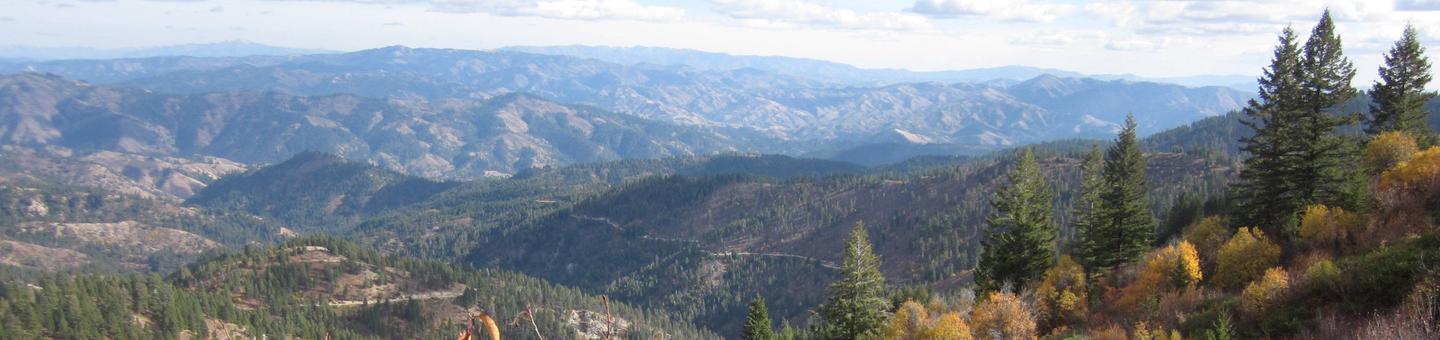
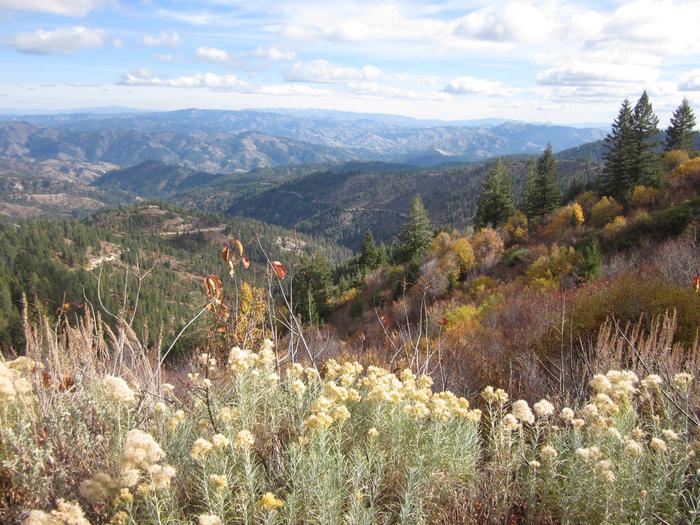
The Boise National Forest is a land of steep mountains, fast rivers and dense forests making it a recreation destination any season of the year. From biking and hiking through lush green mountains and rolling arid landscapes, to snowboarding in cooler months and swimming or kayaking in the warmer ones, the Boise National Forest is the recreational choice for over 1.5 million outdoor enthusiasts every year.
FIRST STOP:
Visit the Interagency Visitor Information Center at 1387 S. Vinnell Street, in Boise, Idaho 83709 for information regarding your public lands. The Center is your one stop shop for recreation information, fuelwood permits, Christmas Tree permits, Federal Agency passes, Motor Vehicle Use maps, Forest Service maps, BLM maps and so much more! Center Hours are 7:45 a.m. to 4:30 p.m. Monday – Friday. 208-373-4007
BEFORE YOU HEAD TO THE FOREST:
Check with the Districts for campground opening and closing dates. View the Alerts & Notices webpage for road and area closures. Remember most of the Forest has no cell phone coverage. Look at each district (Areas & Activities - Find An Area) for a listing campgrounds.
FIRE WATCH:
VIEW AREA CLOSURES DUE TO WILDFIRE ACTIVITY AT ALERTS AND NOTICES PAGE.
INCIWEB- For wildland information, photos, updates and maps go to: http://inciweb.nwcg.gov.
RESERVATIONS: 1-877-444-6777
Go to: www.recreation.gov to make reservations for campgrounds and cabins. Reminder - check on the website for extra vehicle charges, bring cash or a check, no foreign money accepted. Follow rules on America Beautiful Passes - Military passes are free DAY USE ONLY - not camping. (Stated on the back of the card.)
NEW HISTORIC AUTO TOUR:
Download the Ponderosa Pine Scenic Byway Historic Auto Tour and take our tour from Boise to Stanley and back!
RECREATION HIGHLIGHTS:
SCENIC BYWAYS - If you’re interested in taking the scenic route, three Scenic Byways ramble through portions of the Boise National Forest offering unrivaled natural beauty and multiple recreation opportunities.
CABIN RENTALS - Rustic cabins and guard stations once used by Boise National Forest Rangers can be rented for overnight visits. Each offers unparalleled scenic surroundings, numerous outdoor recreation opportunities and abundant wildlife viewing
WATER FUN - Water sports enthusiasts are not hurting for options on the Boise National Forest! With 9,600 miles of rivers and streams, and 15,000 acres of lakes and reservoirs, there is a wide variety of locations for swimming, boating and fishing.
RecAreaDirections
Open with Google Map
Misc
| Stay Limit | |
| Reservable | false |
| Keywords | |
| Map Link | |
| Contact Phone | |
| Contact Email |
Permits info
Facilities
Payette River System Activity Pass
GRAYBACK Campground
List of CampsitesOverview
Grayback Campground is located 36 miles northeast of Boise, Idaho, just off scenic Highway 21. Historic Idaho City is just two miles north of the campground. Visitors enjoy fishing in Mores Creek and exploring the Grayback Gulch Trail. 6/14 Update: Currently water is not available at the Grayback Group sites pump, but Group campers can use the two hand pumbs in the main camgpround, just downhill from the Group sites.
Recreation
Mores Creek can be accessed just below the campground. Anglers fish for whitefish and rainbow trout. Grayback Loop Trail begins within the site, offering a 1-mile footpath for hikers.Numerous trail opportunities are in the area just north of Idaho City, where hiking, biking, horseback riding and off-road vehicles can be enjoyed. During the winter, the area becomes a playground for back country skiers and snowmobiles.
Facilities
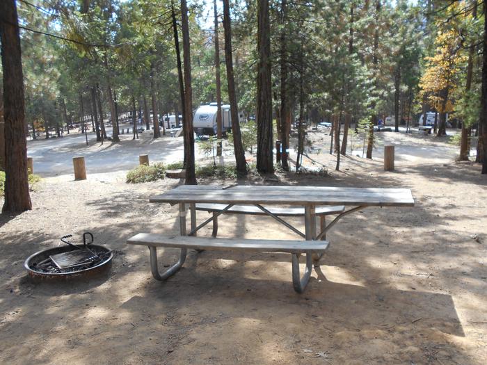
The campground contains two group sites with picnic and serving tables, grills, campfire circles and paved site pads. Site A can accommodate up to 150 people and 20 vehicles, and site B can accommodate up to 100 people and 15 vehicles. Both sites can be reserved at the same time, for even larger groups.Several single- and double-family campsites are available as well, each equipped with a picnic table, lantern post and campfire ring with grill. Vault toilets, drinking water and trash collection are provided throughout the campground. A campground host is located directly across the road.
Natural Features
The campground is situated on a hillside about a quarter-mile above Highway 21, at an elevation of 4,200 feet. A ponderosa pine forest covers the site, offering partial shade. Wildlife and summer wildflowers are abundant in the area.Nearby Attractions
Highway 21, also known as the Ponderosa Pine Scenic Byway, snakes along Mores Creek to Mores Creek Summit, Gold Fork and Banner Ridge, offering historic sites, hot springs pools and breathtaking views of the surrounding mountains and forest along the way to the campground.AMANITA Campground
List of CampsitesOverview
Note: Amanita Campground will be closed for the 2022 season due to pervasive root rot that creates hazard trees. The Forest Service will be conducting selective thinning to remove hazard trees.
Amanita Campground is located next to scenic Lake Cascade in west-central Idaho. It is near the town of Donnelly, at an elevation of 4,850 feet. Boating, fishing, swimming and hiking are popular activities in this scenic region.
Recreation
Lake Cascade offers excellent opportunities for boating, water skiing, canoeing, windsurfing and sailing. Anglers enjoy casting for rainbow trout, coho salmon, smallmouth bass and perch. A boat ramp is located at the neighboring Rainbow Point Campground. Many hiking and ATV trails are in the area as well.Facilities
This small campground contains single-family campsites, with picnic tables, campfire rings and grills. Some sites have lake views and shoreline access.Vault toilets, drinking water and trash collection are provided, but there is no electricity at the campground. Roads and parking spurs within the facility are gravel. A campground host can be located at Rainbow Point Campground.
Natural Features
The campground is situated on the west shore of the lake, among a mixed-growth conifer forest that towers over the campground. Summer wildflowers are abundant in the area.A wide variety of wildlife makes its home around the lake. Waterfowl and songbirds can also be seen in the area, as well as pelicans and bald eagles.
Antelope (Boise National Forest, ID) Campground
List of CampsitesOverview
Antelope Campground is located on the shores of the scenic Sagehen Reservoir in the Boise National Forest, perched at an elevation of 5031 feet. Visitors enjoy boating, fishing and exploring the non-motorized Sagehen Reservoir Trail.Recreation
Sagehen Reservoir offers excellent boating, canoeing and rainbow trout fishing. A boat ramp and dock are located within the campground.The speed limit on the reservoir is 15 mph.Hiking, biking, horse and off-road vehicle trails are abundant in the area. The non-motorized Sagehen Reservoir Trail, a 4-mile loop around the lake, offers great fishing spots, beautiful viewpoints and abundant wildlife watching opportunities.
The Sagehen and KYAOTT ATV Trail Systems can be accessed near the reservoir, offering more than 35 miles of trails for off-road vehicles and motorcycles, but hikers, mountain bikers and horseback riders can enjoy these trails as well.
Facilities
The campground offers a large, tent-only group site that can accommodate up to 30 people, with several picnic tables, a grill and campfire ring. Numerous single-family sites also available, equipped with picnic tables and campfire rings.
Vault toilets and hand-pumped drinking water are provided. Roads and some parking spurs throughout the campground are paved; other spurs are gravel. Firewood is available for purchase from the host.
Natural Features
The campground is situated in a forest of towering Ponderosa pine, Engelmann spruce, Douglas fir and grand fir. Most sites have plentiful shade and some have partial lake views. Summer temperatures range from 80-90 degrees during the day with crisp, cool nights.
A variety of berries and mushrooms can be found throughout the area. Local wildlife includes deer, elk, black bear, goshawk, woodpeckers and boreal owls.
EASTSIDE Campground
List of CampsitesOverview
Eastside Campground is located on the shores of scenic Sagehen Reservoir at an elevation of 4,956 feet. Visitors enjoy boating, fishing and exploring the non-motorized Sagehen Reservoir Trail.Recreation
Sagehen Reservoir offers great boating, canoeing, and rainbow trout fishing. Boat ramps and docks are located nearby at both Antelope and Sagehen Creek Campgrounds. There is a 15 mph speed limit on the reservoir. Hiking, biking, horse, and ATV trails are abundant in the area. The non-motorized Sagehen Reservoir Trail, a 4-mile loop around the lake, offers great fishing spots, beautiful viewpoints, and wildlife watching opportunities for hikers, mountain bikers and horseback riders. The Sagehen and KYAOTT ATV Trail Systems can be accessed near the reservoir, offering more than 35 miles of trails for ATVs and motorcycles, but hikers, mountain bikers and horseback riders can enjoy these trails as well.Facilities
The campground is made up of several single sites or serves as one reservable, accessible group site that can accommodate up to 50 people and 10 vehicles. Most of the campsites afford partial lake views. Picnic tables, campfire rings, a vault toilet, and hand-pumped drinking water are provided. A campground host is located at nearby Antelope Campground, where firewood can be purchased.Natural Features
The campground is situated in a forest of towering Ponderosa pine, Engelmann spruce, Douglas fir, and grand fir. Most sites have plentiful shade. Summer temperatures range from 80 to 90-degree days to cooler nights. A variety of berries and mushrooms can be found throughout the area. Local wildlife includes deer, elk, black bear, goshawk, woodpeckers, and boreal owls.FRENCH CREEK Campground
List of CampsitesOverview
French Creek Campground is located next to scenic Lake Cascade in west-central Idaho. It is near the town of Donnelly, at an elevation of 4,850 feet. Boating, fishing, swimming and hiking are popular activities in this scenic region.Recreation
Lake Cascade offers excellent opportunities for boating, water skiing, canoeing, windsurfing and sailing. Anglers enjoy casting for rainbow trout, coho salmon, smallmouth bass and perch. Many hiking and biking trails are in the area as well.Facilities
The campground is divided into two sections of campsites. Some are located on the east side of West Mountain Road, closer to the lakeshore and with beautiful lake views. Other sites are on the west side of the road, on a hillside above the lake. A few of these sites have partial lake views. Some also have stairs from the parking spur to the campsite.Campsites are equipped with a table and campfire ring. Vault toilets, drinking water and trash collection are provided, but there is no electricity at the campground. Roads and parking spurs within the facility are gravel.
Natural Features
The campground is situated on the western shore of Lake Cascade and on the banks of French Creek. A forest of mixed conifers covers the campground, providing ample shade. Thimbleberry and huckleberry plants are abundant throughout the upper reaches of the campground.A wide variety of wildlife makes its home around the lake. Waterfowl and songbirds are abundant, as well as pelicans and bald eagles.
HOT SPRINGS Campground
List of CampsitesOverview
Hot Springs Campground is located just east of Garden Valley, Idaho along the Banks-Lowman Highway at an elevation of 3169 feet.
Visitors enjoy rafting, kayaking, fishing on the South Fork Payette River, and soaking in the hot springs at the river's edge.
Recreation
The South Fork Payette River is across the road from the campground, offering fishing, whitewater rafting, and kayaking. A natural hot springs soaking pool is located on the river directly across the road and down a staircase.Facilities
The campground contains three accessible group sites with picnic and serving tables, grills and campfire circles with benches. Sites 1 and 2 can accommodate up to 200 people each; Site 3 can accommodate up to 50 people.Vault toilets, drinking water and trash collection are provided. Because of its proximity to the highway, some noise from passing traffic is to be expected.
Natural Features
The campground is situated at the foot of a forested hillside. Towering Ponderosa pines are scattered throughout the site, offering partial shade. Summer wildflowers dot the landscape.Nearby Attractions
Numerous natural hot springs pools can be found along the Banks-Lowman Highway, also known as the Wildlife Canyon Scenic Byway. The area offers scenic views, wildlife watching, historical information kiosks, and several hiking opportunities. Whitewater rafting and kayaking are popular activities on the South Fork and Main Payette Rivers. Several companies in the area offer guided half and full-day trips.RAINBOW POINT Campground
List of CampsitesOverview
Rainbow Point Campground is located next to scenic Lake Cascade in west central Idaho. It is near the town of Donnelly, at an elevation of 4,850 feet. Boating, fishing, swimming and hiking are popular activities in this scenic region.
Note: During the 2022 season, thinning work will be conducted in neighboring Amanita campground to reduce the risk associated with root rot and subsequent hazard trees.
Recreation
Lake Cascade offers excellent opportunities for boating, water skiing, canoeing, windsurfing and sailing. Anglers enjoy casting for rainbow trout, coho salmon, smallmouth bass and perch. A boat ramp is located within the campground. Many hiking and biking trails are in the area as well.Facilities
This small campground offers single-family campsites. Each is equipped with a picnic table, campfire ring and grill. Some sites have lake views and shoreline access.Vault toilets, drinking water and trash collection are provided, but electricity is not available at the campground. Roads and parking spurs within the facility are gravel.
Natural Features
The campground is situated on the west shore of the lake, among a mixed-growth conifer forest that towers over the campground. Summer wildflowers are abundant.A wide variety of wildlife makes its home around the lake. Waterfowl and songbirds can also be seen in the area, as well as pelicans and bald eagles.
SAGEHEN CREEK Campground
List of CampsitesOverview
Sagehen Creek Campground is located on the shores of the scenic Sagehen Reservoir at an elevation of 4997 feet. Visitors enjoy boating, fishing, exploring Joe's Creek Trail, as well as utilizing the non-motorized Sagehen Reservoir Trail.Recreation
Sagehen Reservoir offers great boating, canoeing, and rainbow trout fishing. A boat ramp and dock are located within the campground.There is a 15 mph speed limit on the reservoir. Hiking, biking, horse, and ATV trails are abundant in the area, including Joe's Creek Trail, which begins not far from the campground. The Sagehen Reservoir Trail, a 4-mile loop around the lake, offers great fishing spots, beautiful viewpoints and wildlife watching opportunities for hikers, mountain bikers and horseback riders. The Sagehen and KYAOTT ATV Trail Systems can be accessed near the reservoir, offering more than 35 miles of trails for ATVs and motorcycles, but hikers, mountain bikers and horseback riders can enjoy these trails as well.Facilities
The campground contains several single-family sites, a few of which are accessible, all with picnic tables and campfire rings. Vault toilets and hand-pumped drinking water are provided. Firewood is available for purchase from the host.Natural Features
The campground is situated in a forest of towering Ponderosa pine, Engelmann spruce, Douglas fir, and grand fir, which provide plentiful shade in most sites. Some sites afford lake views. Summer temperatures range from 80 to 90-degree days to cooler nights. A variety of berries and mushrooms can be found throughout the area. Local wildlife includes deer, elk, black bear, goshawk, woodpeckers, and boreal owls.SHORELINE Campground
List of CampsitesOverview
Shoreline Campground is located just across the road from beautiful Warm Lake, at an elevation of 5,300 feet. Visitors enjoy boating, fishing, swimming, hiking and viewing local wildlife.
Recreation
Warm Lake offers great fishing opportunities for cutthroat, rainbow, lake and bull trout. Boating, canoeing and swimming are popular activities. Billy Rice Swim Beach is nearby, offering a day-use site for picnicking and swimming. A boat ramp is located just across the road from the campground.The surrounding area offers great hiking, mountain biking, horseback and off-road vehicle riding, and hunting. The WeWuKiye (Wa Wu Kia) Trail No. 252 is popular among hikers and mountain bikers. It was recently built and can be accessed at the campground's entrance.
For off-road vehicle enthusiasts, Telephone Ridge Trail No. 112 offers 20 miles of trails for all riding levels, with staging areas within the campground and at Warm Lake Campground just down the road.
Facilities
The campground contains several single and double campsites, most of which are accessible. An accessible group site with picnic shelter is also available and can accommodate up to 50 people. A volleyball court and horseshoe pits are located next to the group site.Picnic tables, campfire rings and grills are available at the campsites. Vault toilets and drinking water are also provided. There is no electricity at the campground.
Natural Features
The campground is situated in a mixed-growth lodgepole pine forest, which offers partial shade. Summer wildflowers are abundant in the area. A variety of wildlife including bears, deer, elk, fox, grouse, eagles, osprey, grosbeaks, whooping cranes and otters, lives around the lake.MOUNTAIN VIEW Campground
List of CampsitesOverview
Mountain View Campground is located just east of Lowman, Idaho, along Highway 21 at an elevation of 3,900 feet. Visitors enjoy rafting, kayaking and fishing on the South Fork Payette River, and soaking in the area's many hot springs pools.Recreation
The South Fork Payette River offers whitewater rafting, kayaking and trout fishing. The Deadwood and Danskin River Access areas are nearby.Popular Kirkham Hot Springs is less than 3 miles from the campground, with several soaking pools on the river's edge.
Facilities
The campground contains several single-family sites, all of which are accessible, each with a picnic table, campfire ring and grill. Vault toilets, drinking water and trash collection are provided. A campground host is on-site. Roads and parking spurs are paved.Natural Features
Towering Ponderosa pines cover the campground, offering partial shade in most sites. Summer wildflowers dot the landscape. Deer and elk may be seen wandering through the area on occasion.Nearby Attractions
Numerous natural hot springs pools can be found along Highway 21, the Ponderosa Pine Scenic Byway and the Banks-Lowman Highway, also known as the Wildlife Canyon Scenic Byway. Both byways offer scenic views, wildlife watching, historical information kiosks and several trail opportunities.Whitewater rafting and kayaking are popular activities on the South Fork and Main Payette Rivers. Several companies in the area offer guided half and full-day trips.
PARK CREEK (IDAHO) Campground
List of CampsitesOverview
Park Creek Campground is located 4 miles from Lowman, Idaho, off the beaten path at the confluence of Park and Clear Creeks. Visitors enjoy fishing, hunting and exploring local trails.Recreation
Park Creek and Clear Creek both offer good trout fishing. Various hiking, biking, horseback and off-road vehicle riding trails are in the vicinity.Facilities
The campground contains two group sites available by advanced reservations, each can accommodate up to 100 people per group site. The Rainbow Group Site are sites 1-12, and the Trout Group Site are sites 13-24. Picnic tables, campfire rings and grills are provided, as are vault toilets, drinking water and trash collection. Roads and parking spurs are dirt.When not reserved as a group site, the sites are available on a first-come, first-served basis. If both Rainbow and Trout Group Sites are reserved there will be no first-come, first-served sites available. Prior to arrival, please check the campground status on the reservation board on the 582 road located 300 feet north of the 21 junction to see if there are any pending reservations.
Natural Features
Towering Ponderosa pine and Douglas fir trees forest the campground, offering plentiful shade. Summer wildflowers dot the landscape. A variety of wildlife lives in the area, including black bears, deer and elk.Nearby Attractions
Beautiful Bear Valley is up the road from Park Creek, offering scenic views, wildlife watching and numerous trail opportunities for hiking, biking, horseback and off-road vehicle riding.Several natural hot springs pools can be found along the Banks-Lowman Highway, also known as the Wildlife Canyon Scenic Byway, and Highway 21, the Ponderosa Pine Scenic Byway. Both byways also offer pretty scenery, wildlife viewing, historical information kiosks and trail opportunities.
Whitewater rafting and kayaking are popular activities on the South Fork and Main Payette Rivers; several companies in the area offer guided half and full-day trips.
DOG CREEK (ID) Campground
List of CampsitesOverview
Dog Creek Campground is located on the banks of Dog Creek, at the foot of the Trinity Mountain Range. It is four miles from the town of Pine, in south-central Idaho. Visitors enjoy fishing, swimming and exploring local trails.Recreation
The South Fork Boise River is less than a quarter-mile away from the campground, offering rafting, swimming and fishing for rainbow trout. Paradise Hot Springs is nearby.Green Creek Trail 270, a 4.5-mile trail for hiking, horseback riding, biking and off-road vehicles, begins a mile from the site. Cross Cut Trail 172 begins close by and is open to hiking, biking, horseback riding and off-road vehicles.
Facilities
This quiet campground sits off the main road. It offers two small group campsites that can accommodate up to 15 people each. Eleven single-family campsites are available as well. Vault toilets and drinking water are provided. Roads and parking spurs within the campground are gravel.Natural Features
The campground is situated in a scenic ponderosa pine forest, at an elevation of 4,600 feet. Summer wildflowers are plentiful and deer and hummingbirds frequent the area.Nearby Attractions
Baumgartner Hot Springs is approximately 16 miles away with a soaking pool and nature trail. Kelly Creek Flats Recreation Area is adjacent to Baumgartner, with several more trail opportunities.SHAFER BUTTE Campground
List of CampsitesOverview
Shafer Butte is located atop the scenic Boise Ridge Mountains, near Bogus Basin Mountain Recreation Area, at an elevation of 7,000 feet. Visitors enjoy hiking and biking on various trails in the surrounding area, and simply relaxing and taking in the area's beautiful views.Recreation
Popular activities in the area include hiking and mountain biking, the Mores Mountain Trail begins in the campground. This 2-mile interpretive nature trail is family friendly.Facilities
Shafer Butte contains single-family tent campsites and two day-use, group picnic areas, all of which are accessible. Sites are equipped with picnic tables and campfire rings, and many of the overnight campsites have tent pads. The overnight sites are walk-in and are clustered close together, with limited vegetation screening for privacy. Accessible vault restrooms are provided, but there is no electricity. Parking spurs and pathways within the campground are paved, and each site can be accessed via a short walking path from the parking area.Natural Features
Shafer Butte offers scenic views of Deer Point, Mores Mountain and Shafer Butte summits, as well as the expansive valley below. The campground is situated among Douglas fir and aspen trees, which offer partial shade in most sites. Wildlife and summer wildflowers are abundant in the area.Nearby Attractions
Bogus Basin Mountain Recreation Area is close by and offers more hiking and biking trails, as well as other summer activities, check out this link for more information http://bogusbasin.org. The Ridge to River trail system is near by as well, check out this link for more information http://www.ridgetorivers.orgTHIRD FORK CABIN Campground
List of CampsitesOverview
Third Fork Cabin is a former guard station, first established in 1906 as Station 10 and renamed Third Fork in 1908. A cabin was built at that time, which
existed until the site was rebuilt by the Civilian Conservation Corps in 1933. The current cabin's exterior has changed little since that time, with the exception of a metal roof being added sometime before 1984.
The cabin is available between mid-April until late-October, and is accessible by car. Many modern comforts are provided at the cabin, but guests may need to bring some additional supplies and gear for their stay.
Recreation
Anglers can fish in adjacent Squaw Creek, and big game hunting is also a popular pastime.Facilities
This rustic cabin sleeps four people with one double bed and two single beds with mattresses. Other amenities include a propane cook range, table with chairs, hot water heater, indoor flush toilet, shower and propane heater and refrigerator. A picnic table, campfire ring and pedestal grill sit within the fenced yard.
A camp host is located at Antelope Campground, 18 miles east in the Sagehen Reservoir area, where firewood can be purchased.
While the water at the cabin is potable, guests should bring their own supply of drinking water as a back-up. Bedding, lighting, cookware and utensils are not provided. Guests are expected to clean the cabin before leaving.
Natural Features
Third Fork Cabin sits in a steep mountain landscape heavily forested with old-growth Ponderosa pine at an approximate elevation of 4,700 feet. Tall grasses and various hardwoods grow on the site. Small mountain streams containing native fish flow nearby, and the area is marked by unusual juxtapositions of basalt and granitic rock.
Wildlife watchers may spot elk or deer wandering through the area during dawn or dusk, as well as glimpse a bear or moose. Birders can look for a wide variety of bird species.
Nearby Attractions
Sagehen Reservoir is a popular recreation area about 18 miles east of the cabin, offering numerous trails for off-road vehicles, hiking, mountain biking and horseback riding. Click here for an Idaho OHV safety message. Fishing and boating are permitted in the reservoir, and there is also a picnic area at Sagehen Dam.BOILING SPRINGS CABIN Campground
List of CampsitesOverview
Boiling Springs Cabin is a popular destination for those who enjoy soaking in mineral hot springs that are adjacent to the cabin. Other hot springs are within the vicinity as well. Guests who stay here also have a variety of other recreational activities to enjoy, such as fishing, hiking, and off-road motor vehicle riding.
The cabin was renovated in 2012 and offers many conveniences, but guests should bring some supplies and equipment to ensure a comfortable and enjoyable stay.
The cabin is accessible by car in warmer months and by snowmobile in winter. Guests arriving in snowy conditions should be prepared to snowmobile 11 miles to the cabin from the Middle Fork snowmobile parking lot.
Recreation
Numerous hiking, biking, horse and off-road vehicle trails are in the vicinity, including the Middle Fork Trail. Many miles of groomed snowmobile trails criss-cross the area in winter. Snowshoers and cross-country skiers can also use the trails in winter.
Sections of the Middle Fork Payette River offers opportunities for rafting, canoeing, kayaking, and swimming. Anglers can fish for rainbow and bull trout. Big game hunting is a popular activity in the surrounding mountains.
Guests can soak in the on-site hot springs during their stay, and a few other hot springs are also nearby for soaking.
Facilities
The cabin accommodates five people. Sleeping quarters consist of one bedroom with wood stove and includes three single beds (one providing a trundle bed) with mattresses. A couch, table and chairs, sink, propane cook range and refrigerator, and wood stove are located in the front room. Some dishes, pots and pans, and other kitchenware are available. Firewood is provided October 15 through December 31, but it may need to be split.
A vault toilet, picnic table and campfire ring are located outside the cabin. Camp hosts are available during the summer months at Trail Creek Campground and Boiling Springs Campground.
Potable water is available (hand pump outside) during the summer season only. Electricity is not available. Guests need to supply their own lighting and garbage bags. Guests are expected to clean the cabin before leaving. Bedding, pillows, and an axe are not provided.
Natural Features
Boiling Springs Cabin is located at an elevation of 4025 ft. in a narrow mountain valley situated between a hot springs, a stream, and the Middle Fork Payette River. The surrounding mountains are steep and densely forested with conifers, but the cabin sits in an open meadow with little shade.
Wildlife enthusiasts may spot nesting ospreys along the Middle Fork Payette River. Elk and deer are often spotted grazing along its banks. Bald eagles, hawks, quail and a variety of waterfowl also inhabit the area.
BIG TRINITY CABIN Campground
List of CampsitesOverview
Big Trinity Cabin offers a quiet retreat in a beautiful high alpine landscape. The cabin is situated within a popular summer recreation area with many activities to enjoy. The cabin has a limited season due to late snow melt, but is accessible by vehicles with reasonable ground clearance. Many creature comforts are provided; however, guests may want to bring some supplies and gear to make their experience more comfortable and enjoyable.Recreation
The 4- mile Rainbow Basin Trail system for pedestrain travel only, offers access to several lakes, hikers can access the trail System from the trailhead located within Big Trinity Lake campground. Other trails within the area Roaring River trail 045, and Lava Mountain trail 125, these are motorized motorcycle trails. Click here for an Idaho OHV Safety Message. Anglers can fish in any of the nearby lakes for rainbow and cutthroat trout. The lakes are also ideal for exploring by canoe or kayak.Facilities
The cabin sleeps six and is equipped with one double bed, a sofa bed, side tables, a drop-down kitchen table, cleaning supplies, dishes and tableware, chairs and a dining table, cookware and a fire extinguisher. A wood stove is available for heating and cooking.
A picnic table and campfire ring with grill are provided outside. Drinking water is available from a nearby hand pump. The cabin is stocked with seasoned wood, a splitting maul, axe and hatchet. A vault restroom is located outside.
No electricity or propane is available. Guests must bring garbage bags to pack out their trash. Bedding, lighting and emergency supplies are not provided. Guests are responsible for cleaning the cabin before leaving.
Natural Features
The cabin is located in a dense lodgepole pine forest close to the East Fork Roaring River at an elevation of 7,900 feet. It's nestled among four subalpine lakes: Big Roaring River Lake, Little Roaring River Lake, Big Trinity Lake and Little Trinity Lake. The peaks of the Boise Mountains surround the cabins, and Trinity Mountain, the tallest in the range at 9,451 feet, is just to the south. Snow can make this area inaccessible until early July, but soon afterward, the land is blanketed by colorful summer wildflowers. This area is a haven for elk and deer, but wildlife watchers may also spot an occasional black bear.Nearby Attractions
The summit of Trinity Mountain is the highest drivable point in Idaho, although the road may be blocked by snow until early July. A short, steep hike takes visitors to the lookout tower for panoramic views of several subalpine lakes and other mountains in the Boise Range.HELENDE Campground
List of CampsitesOverview
Helende Campground is located 10 miles east of Lowman, Idaho, along Highway 21 at an elevation of 4,100 feet. The South Fork Payette River lies a few hundred yards away. Visitors enjoy fishing and rafting on the river, soaking at nearby Kirkham Hot Springs and exploring the extensive Kirkham Ridge Trail.Recreation
The South Fork Payette River offers whitewater rafting, kayaking and trout fishing. The Deadwood and Danskin River Access areas are nearby.Popular Kirkham Hot Springs is less than 5 miles west of the campground along Highway 21. A trail with staircases leads down to the soaking pools on the riverside.
Kirkham Ridge Trail is one of the Lowman Ranger District's premier trails. It begins near Kirkham Campground and stretches through beautiful country for 35 miles, connecting with many other trails in the area. It is open to hiking, mountain biking and horseback riding. Sections of the trail are open seasonally to off-road vehicles.
Facilities
The campground contains single-family sites, all of which are accessible. Each site is equipped with a picnic table and campfire ring with grill. Vault toilets, drinking water and trash collection are provided.Natural Features
The campground is situated in a dense forest of lodgepole and Ponderosa pine, which offers plentiful shade in most sites. Summer wildflowers dot the landscape. Deer and elk may be seen wandering through the area on occasion.Nearby Attractions
Numerous natural hot springs pools can be found along the Banks-Lowman Highway, also known as the Wildlife Canyon Scenic Byway and Highway 21, the Ponderosa Pine Scenic Byway. Both byways offer scenic views, wildlife watching, historical information kiosks and several trail opportunities.Whitewater rafting and kayaking are popular activities on the South Fork and Main Payette Rivers. Several companies in the area offer guided half and full-day trips.
BONNEVILLE Campground
List of CampsitesOverview
Bonneville Campground is 19 miles east of Lowman, Idaho just off Highway 21 at an elevation of 4,700 feet. Warm Springs Creek runs alongside the campground and the South Fork Payette River lies across the highway. Visitors enjoy soaking at Bonneville Hot Springs a short distance above the campground, and fishing in the creek and river.Recreation
A 1/4-mile hiking trail leads from the campground to Bonneville Hot Springs, where a soaking pool awaits. Warm Springs Creek offers good trout fishing.The South Fork Payette River offers whitewater rafting, kayaking and trout fishing. The Deadwood River Access area is located near Lowman.
Facilities
The campground contains several accessible single-family sites and one double site, each equipped with a picnic table and campfire ring with grill. Vault toilets, drinking water and trash collection are provided. A campground host is on-site.Natural Features
The campground is situated on a bluff overlooking Warm Springs Creek. A forest of towering Ponderosa pine and Douglas fir covers the campground. Most campsites have plentiful shade. Summer wildflowers dot the landscape. Deer and elk may be seen wandering through the area on occasion.Nearby Attractions
Numerous natural hot springs pools can be found along Highway 21, also known as the Ponderosa Pine Scenic Byway, and the Banks-Lowman Highway, also known as the Wildlife Canyon Scenic Byway. Both byways offer scenic views, wildlife watching, historical information kiosks and several trail opportunities.Whitewater rafting and kayaking are popular activities on the South Fork and Main Payette Rivers. Several companies in the area offer guided half and full-day trips.
PINE FLATS (ID) Campground
List of CampsitesOverview
Pine Flats Campground is located a few miles west of Lowman, Idaho, along the Banks-Lowman Highway at an elevation of 3,700 feet. Visitors enjoy rafting, kayaking and fishing on the South Fork Payette River, and soaking in the hot springs at the river's edge.Recreation
The South Fork Payette River flows next to the site, down a small hill, and offers trout fishing, rafting and kayaking. The Danskin River Access area is 5 miles west of the campground.A 1/4-mile nature trail begins in the campground and leads to a natural hot springs soaking pool on the riverside.
Facilities
The campground contains several single and double-family sites, most of which are accessible, each with a picnic table and campfire ring with grill. Vault toilets, drinking water and trash collection are provided. Roads and parking spurs are paved, as are some campsite pads.Natural Features
Towering Ponderosa pines cover the campground, offering partial shade in most sites. Summer wildflowers dot the landscape. Deer and elk may be seen wandering through the campground on occasion.Nearby Attractions
Numerous natural hot springs pools can be found along the Banks-Lowman Highway, also known as the Wildlife Canyon Scenic Byway. The area offers scenic views, wildlife watching, historical information kiosks and several trail opportunities.Whitewater rafting and kayaking are popular activities on the South Fork and Main Payette Rivers. Several companies in the area offer guided half and full-day trips.
KIRKHAM Campground
List of CampsitesOverview
Kirkham Campground is located next to the South Fork Payette River just east of Lowman, Idaho, along Highway 21 at an elevation of 4,000 feet. Visitors enjoy soaking in popular Kirkham Hot Springs on the banks of the river and exploring the scenic Kirkham Ridge Trail.
Recreation
Popular Kirkham Hot Springs is located at the river's edge within the campground. A trail with staircases leads down to the soaking pools and small steaming waterfalls.The South Fork Payette River offers whitewater rafting, kayaking and trout fishing. The Deadwood and Danskin River Access areas are nearby.
Kirkham Ridge Trail is one of the Lowman Ranger District's premier trails. It begins less than 1/4-mile away and stretches through beautiful country for 35 miles, connecting with many other trails in the area. It is open to hiking, mountain biking and horses. Sections of the trail are open seasonally to off-road vehicles.
Facilities
The campground contains several single-family sites and one double site, all of which are accessible. Each site is equipped with a picnic table and campfire ring with grill. Some sites have small picnic shelters for shade.Vault toilets, drinking water and trash collection are provided. A campground host is on-site. Roads and parking spurs are paved. A small gas station/cafe and mechanic are nearby.
Natural Features
The campground offers little shade, though a few Ponderosa pines are scattered throughout the site. The campground can be very hot and sunny during the summer. Wildflowers dot the landscape.Nearby Attractions
Numerous natural hot springs pools can be found along Highway 21, also known as the Ponderosa Pine Scenic Byway, and the Banks-Lowman Highway, also known as the Wildlife Canyon Scenic Byway. Both byways offer scenic views, wildlife watching, historical information kiosks and several trail opportunities.Whitewater rafting and kayaking are popular activities on the South Fork and Main Payette Rivers. Several companies in the area offer guided half and full-day trips.
ELKS FLAT CAMPGROUND Campground
List of CampsitesOverview
Elks Flat Campground is situated on the banks of the South Fork Boise River, at the foot of the Trinity Mountain Range in Idaho. It is five miles north of the town of Pine. Visitors enjoy fishing, swimming and exploring trails in the surrounding area.Recreation
The South Fork Boise River runs along the eastern edge of the campground, offering rafting, swimming and fishing for rainbow trout. Paradise Hot Springs is nearby.Green Creek Trail 270, a 4.5-mile trail for hiking, horseback riding and dirt bikes, begins a mile from the site. Cross Cut Trail 172 also begins close by and is open to hiking, biking, horseback riding and off-road vehicles.
Facilities
This campground contains two large-group campsites that can accommodate up to 100 people. Each site is equipped with covered pavilions, picnic tables and cement site pads. Vault toilets and drinking water are provided. Roads and parking spurs within the campground are gravel.Natural Features
The campground is settled in a grassy meadow. It is surrounded by stands of cottonwood, aspen, Douglas fir and ponderosa pine, at an elevation of 4,400 feet.Nearby Attractions
Baumgartner Hot Springs is approximately 16 miles away with a soaking pool and nature trail. Kelly Creek Flats Recreation Area is adjacent to Baumgartner with several more trail opportunities.SWINGING BRIDGE Campground
List of CampsitesOverview
Swinging Bridge Campground is located 10 miles north of Banks, Idaho just off Highway 55 at an elevation of 4,000 feet.The North Fork Payette River flows next to the highway, where extreme kayaking is a popular activity.
Recreation
The North Fork of the Payette River is a very popular location for expert kayaking. Whitewater rafting is nearby on the Main and South Fork sections of the Payette River.Anglers will find good to excellent fishing for whitefish and rainbow trout.
Facilities
The campground contains single-family sites, each with a picnic table and campfire ring. Vault toilets are provided. Roads and parking spurs are paved. Because of its proximity to the highway, some noise from passing traffic is to be expected.Natural Features
The campground is situated is a scenic canyon just above Highway 55. The mountains are forested with a mix of Ponderosa and lodgepole pines and shade is plentiful within most of the campground. Summer days are warm, reaching 80-90 degrees; nights are cooler.HAYFORK GROUP CG Campground
List of CampsitesOverview
Hayfork Group Campground is located 49 miles northeast of Boise, Idaho, along scenic Highway 21. Historic Idaho City is just 12 miles south of the campground. Visitors enjoy fishing in Mores Creek and exploring local trails.
Recreation
Mores Creek runs between the highway and the campground, offering whitefish and rainbow trout fishing.Numerous trails are in the area, providing ample opportunities for hiking, biking, horseback riding and off-road vehicle riding. In the winter, the area becomes a playground for back country skiers and snowmobiles.
Facilities
The campground provides one large-group campsite for reservation. It can accommodate up to 50 people and is a great location for family reunions or small weddings. The site is equipped with multiple tables, a grill and a campfire circle with benches.Vault toilets, drinking water and trash collection are provided. Parking spurs are gravel. Due to the campground's proximity to the highway, some noise from passing traffic is to be expected.
Natural Features
The campground is situated at the foot of a ponderosa pine-forested hillside along Highway 21, at an elevation of 5,100 feet. The campsite, however, is in an open area with limited shade. Wildlife and summer wildflowers are abundant in the surrounding area.Nearby Attractions
Highway 21, also known as the Ponderosa Pine Scenic Byway, snakes along Mores Creek to Mores Creek Summit, Gold Fork and Banner Ridge, offering historic sites, hot springs pools and breathtaking views of the surrounding mountains and forest along the way.WARM SPRINGS GUARD STATION Campground
List of CampsitesOverview
Historic Warm Springs Guard Station is open year-round and has recently been restored to reflect its original finishes and paint. It's accessible by car from mid-April through mid-December but can only be reached by snowshoes or cross-country skis for the remainder of the year. This charming cabin offers a rustic retreat with a few amenities. Guests should be prepared to bring most of the supplies and gear they need for a comfortable stay. PLEASE CALL THE DISTRICT OFFICE WITH YOUR RESERVATION NUMBER DURING REGULAR BUSINESS HOURS (8AM - 4:30PM EXCEPT HOLIDAYS) FOR COMBINATIONS AND OTHER INQUIRIES AT 208-259-3361.Recreation
Some hiking trails are nearby. One trail leads to Bonneville Hot Springs, which is accessible by snowshoes and skis in the winter. Visitors can soak in the waters while enjoying the beautiful surroundings. The South Fork Payette River offers opportunities for trout fishing and swimming. The area around the cabin is a cross-country skiing and snowshoeing playground in winter.Facilities
The cabin sleeps six people and comes with one double bed and three single beds with mattresses. A small couch and a wood stove are located in the front room. Firewood is provided in the adjacent barn, but it may need to be split. The kitchen is equipped with a dry sink, a table with chairs, and a propane fridge and stove. Some pots and pans and a coffee pot are provided. A campfire ring and an outhouse with vault toilet are located outside the cabin. A hand pump for water is available for summer use. No water is available at the cabin in the winter, but snow can be melted. No electricity is provided. Guests must bring garbage bags to pack out trash. Items like bedding, lanterns or flashlights, matches, first aid supplies, extra toilet paper and an axe are not available.Natural Features
Towering Ponderosa pines forest this pretty site located in a narrow mountain valley along the South Fork Payette River. The cabin sits at an elevation of 4,700 feet amid steep mountain peaks. This is a wintering area for deer and elk. Summer visitors to the area may see black bears. A variety of bird species make the forest their home year-round.Nearby Attractions
Highway 21, just below the guard station, is known as the Ponderosa Pine Scenic Byway. This 131-mile route starts in Boise and meanders through Boise, Salmon-Challis and Sawtooth National Forests, with several points of interest along the way.ELK CREEK CABINS Campground
List of CampsitesOverview
Elk Creek Cabins are open from November through April, offering a rustic retreat for winter sports enthusiasts. Guests must be prepared to snowmobile, snowshoe or ski at least 15 miles from the parking area to the cabin, and they are responsible for their own travel arrangements and safety.These cabins offer a few amenities, but guests will need to bring some of their own equipment and supplies to make their stay comfortable.
Recreation
Thirty miles of groomed trails surround the cabins, offering excellent snowmobiling, cross-country skiing and snowshoeing. Skiers and snowshoers can enjoy a backcountry adventure in the Frank Church - River of No Return Wilderness, but snowmobiles are not allowed.Facilities
Cabin 1 can accommodate up to 10 people on three double beds and four cots with mattresses. The kitchen is equipped with a dry sink, propane stove and refrigerator. A fireplace, couch, chairs and dining table with chairs are in the front room. A wood stove is located off the kitchen for heating. Cabin 2 has two bedrooms that can accommodate a total of eight people. One single bed with mattress, three cots and two additional mattresses are provided. The kitchen is equipped with a dry sink, propane stove, table and chairs, a couch and wood stove. A picnic area and an outhouse with a vault toilet are located outside. Both cabins come equipped with some cookware and utensils for cooking and eating. Firewood for both cabins is provided in a woodshed, but may need to be split. An axe and splitting maul are provided. Neither cabin has electricity or water. Guests must bring their own water as well as garbage bags for packing out trash. Bedding, lighting and emergency supplies are not provided.Natural Features
Elk Creek Cabins are located in beautiful but remote Bear Valley at an elevation of 6,400 feet. They are adjacent to the Frank Church - River of No Return Wilderness and scenic Elk Creek. The cabins are situated in a high mountain meadow dotted with Douglas fir and lodgepole pine amid the peaks of the Sawtooth Range. Winter highs are typically in the 20-30 degree range, with lows averaging -15 to +5 degrees. Deep snow blankets the landscape during the winter months. Wildlife enthusiasts can watch carefully for snowshoe hares or ermine with their white winter coats. Deer, elk, moose, red squirrels, coyote and lynx are all active in the winter.STOLLE MEADOWS CABIN Campground
List of CampsitesOverview
Note: Stolle Meadows will be unavailabe after Mid July for contractors to conduct repairs and restoration work.
Historic Stolle Meadows Cabin is a single-room dwelling that has been restored to near original condition. it's located in a beautiful setting near a variety of
recreational activities. The cabin is available year-round.
The route to the cabin is drivable in warmer months but is only accessible by a 6.5-mile ski or snowmobile trek in the winter. Many conveniences are provided for a comfortable and pleasant experience, but guests may want to bring some additional gear and supplies.
Recreation
Beautiful Warm Lake is less than 5 miles from the cabin, offering boating, canoeing and fishing for rainbow, cutthroat, lake and bull trout. Billy Rice Swim Beach, on the north shore of the lake, is a great day-use site for picnicking and swimming. Numerous hiking, biking, horse and off-road vehicle trails crisscross the area around the lake. Click here for an Idaho OHV safety message. A popular activity is to explore nearby Vulcan Hot Springs, about 1.5 miles away. Winter activities include snowshoeing, cross-country skiing and sledding. Hunting season brings out hunters in search of big game.Facilities
The cabin contains one double bed and one twin trundle bed with mattresses, a table and chairs, dry sink, wood stove and firewood, propane cooking stove with fuel, pots and pans, dishes, tableware, solar lights and a first aid kit. An axe and maul are provided to split firewood. An outhouse with vault toilet and a picnic table are located outside. Drinking water is available year-round from a hand pump outside the cabin. No electricity is available at the cabin. Guests should consider bringing backup lighting in case the solar powered lights are dim. Garbage bags must be brought in to pack out trash. Bedding and pillows are not provided.Natural Features
The cabin is nestled in a mixed-growth lodgepole pine forest on a bluff overlooking Stolle Meadows at an elevation of 5,300 feet. Above the forest, mountain peaks rise into the sky. Many wildlife species make their home here. Elk, deer, moose, bear and a variety of other animals frequent the forest. Snowshoe hares and ermine are active in winter, though they may be hard to spot with their white winter coats.Nearby Attractions
Near Stolle Meadows is a South Fork Salmon River site where visitors can watch Chinook salmon spawn every August. A boardwalk features interpretive signs.WARM LAKE Campground
List of CampsitesOverview
Warm Lake Campground is near the eastern shore of beautiful Warm Lake, at an elevation of 5,300 feet. Visitors enjoy boating, fishing, swimming, hiking and viewing local wildlife.
Recreation
Warm Lake offers great fishing opportunities for cutthroat, rainbow, lake and bull trout. Boating, canoeing and swimming are popular activities. A developed swim beach is available less than a quarter-mile away, at Warm Lake Lodge.Billy Rice Swim Beach is just over a mile from the campground, on the north side of the lake. The area offers a day-use site for picnicking and swimming. A boat ramp is located at nearby Shoreline Campground.
The surrounding area offers great hiking, mountain biking, horseback and off-road vehicle riding, and hunting. The WeWuKiye (Wa Wu Kia) Trail No. 252 was recently built and can be accessed at Shoreline Campground. It is popular for hiking and mountain biking.
For off-road vehicle enthusiasts, Telephone Ridge Trail No. 112 offers 20 miles of trails for all riding levels, with staging areas within the campground and up the road at Shoreline Campground.
Facilities
This small campground provides campsites equipped with a picnic table, campfire ring and grill. Vault toilets, drinking water and trash collection are provided at the campground, but electricity is not available.Roads and parking spurs within the facility are gravel. The lake is not visible from the campground.
Natural Features
The campground is situated in a scenic forest of towering, old-growth ponderosa pine, which provides partial shade in the campground. Chipmunk Creek runs alongside the campground. Summer wildflowers are abundant.A variety of wildlife including bears, deer, elk, fox, grouse, eagles, osprey, grosbeaks, whooping cranes and otters, lives around the lake.
Nearby Attractions
Warm Lake Lodge is located across the road from the campground and has a restaurant and small store with camping and fishing essentials.BULL TROUT Campground
List of CampsitesOverview
Bull Trout Campground is located on the shores of beautiful Bull Trout Lake at an elevation of 6,900 feet. The lake offers great fishing and canoeing opportunities. Many trails for hiking, biking, horseback and off-road vehicle riding are in the area. Only equestrian users may reserve equestrian sites. If an equestrian site is not reserved, it may be occupied by other user groups on a first-come, first-served basis.
Recreation
Bull Trout Lake offers excellent canoeing and kayaking opportunities, as the lake is for non-motorized watercraft only. Anglers fish for brook and rainbow trout. A primitive boat ramp is located on the west side of the lake.Martin Lake is nearby, offering canoeing and fishing. The lake is stocked with rainbow trout.
Many miles of trails can be found in the area, including the 11-mile Warm Spring Trail for hikers. The 35-mile Kirkham Ridge Trail is open to hiking, mountain biking, horseback riding and dirt biking.
Facilities
This campground contains group, equestrian and single and double campsites, many of which are accessible. The group sites can accommodate up to 50 people each. Equestrian sites each contain a corral and large parking spur. Some sites are on the waterfront and have direct lake access, others have lake views.Vault toilets, drinking water and trash collection are provided. Roads and parking spurs within the campground are dirt. A campground host is on-site.
Natural Features
The campground is situated in a mixed-growth forest of Douglas fir and lodgepole pine, which offers partial shade. Summer wildflowers are abundant.JOHNSON CREEK GUARD STATION Campground
List of CampsitesOverview
Johnson Creek Guard Station was built in 1922 and offers a charming mountain respite with modern conveniences. The cabin offers nearly everything needed for a pleasant and comfortable stay.Peak season for the cabin is typically early June through late September. It can be accessed by most vehicles via dirt and gravel roads, but trailers are not recommended.
Recreation
The cabin is near several trailheads into the Frank Church - River of No Return Wilderness. These non-motorized trails are popular for hikers, mountain bikers and equestrians. Off-road vehicle trails are also nearby. Click here for an Idaho OHV safety message.The South Fork Salmon River and Johnson Creek offer opportunities for fishing. Berry picking and hunting are popular pastimes in season.
Facilities
The rustic cabin has two twin beds with mattresses in the loft, as well as two cots, a couch and a heater. A full size bed is in separate bedroom. The kitchen is equipped with a table and four chairs, an electric range and a refrigerator. Cookware and utensils are provided, including saucepans, pots and lids, plates, bowls, cups, mugs, utensils, knives, a cutting board, salad bowl and cookie sheet. A modern bathroom with a flush toilet and shower is available. Two picnic tables, a campfire ring and two grills are located outside behind the cabin. Guests must bring garbage bags to pack out their own trash. Bedding, lanterns or flashlights, towels and emergency drinking water are not provided.Natural Features
Johnson Creek sits in a pretty mountain meadow a stone's throw from scenic Johnson Creek, a tributary of the South Fork Salmon River. Mountain slopes covered in dense pine forest surround the cabin.Wildlife watchers may see deer, elk, bear and moose. Bald eagles are often spotted soaring overhead.
Nearby Attractions
The tiny community of Yellow Pine is a few miles north of the cabin and offers limited services. The popular Yellow Pine Music & Harmonica Festival is held annually in August.PEACE VALLEY CAMPGROUND Campground
List of CampsitesOverview
Peace Valley Campground sits just 27 miles north of Garden Valley, Idaho, at an elevation of 4591 feet. The beautiful Peace Valley offers excellent hiking, motorcycle riding, fishing, and hunting opportunities.Recreation
Peace Valley offers several trails for hiking, mountain biking, horseback riding, and OHV use. Peace Creek Trail and Bitter Creek Trail (both motorcycle trails) begin nearby. The Rattlesnake Trail and 465 ATV Trail are in the vicinity of the campground.
Peace Creek and nearby Silver Creek offer excellent fishing most of the year. Anglers cast for whitefish and rainbow trout.
In-season big game hunting for deer, elk, and bear is a popular activity in the surrounding mountains.
Facilities
This fully-accessible campground is a small facility with just five campsites that make up one group site that can accommodate up to 50 people. Picnic tables, grills, a small picnic shelter, and campfire rings are provided. Parking spurs can accommodate small to medium RVs up to 30 feet in length. Vault toilets and drinking water are available.Natural Features
The surrounding area consists of high, forested mountains, and steep valleys. The campground lies close to an experimental forest and a fire lookout.
A variety of wildlife makes its home in and around Peace Valley, including deer, elk, bald eagles, and red-tailed hawks.
Nearby Attractions
Silver Creek Plunge, a privately-developed hot springs resort, is 2.5 miles away with a hot springs pool, general store, concessions, a playground, horseshoe pits, and both volleyball and basketball courts.EDNA CREEK CAMPGROUND Campground
List of CampsitesOverview
Edna Campground is located 56 miles northeast of Boise, Idaho, in a scenic Ponderosa pine forest along Highway 21 at an elevation of 5,700 feet. Wildlife and summer wildflowers are abundant. Historic Idaho City is just 11 miles south. Crooked River runs near the site, offering whitefish and rainbow trout fishing.This campground contains 9 site that can accommodate up to 6 people each. Picnic tables, a BBQ grill, and fire ring with benches are provided. The site is in an open area with shade. Vault toilets and garbage service are provided. Parking spurs are graveled. Due to its proximity to the highway, some noise from passing traffic is to be expected.
Highway 21, also known as the Ponderosa Pine Scenic Byway, snakes along Mores Creek to Mores Creek Summit, Gold Fork, and Banner Ridge with breathtaking views of the surrounding mountains and forest. Numerous trail opportunities are in the area, offering hiking, biking, horseback riding, and ATVing. In winter, the area becomes a playground for backcountry skiers and snowmobilers.
Facilities
Each site has a picnic table and fire ring. Vault toilets provided. Water pump provided. No trash service.
BAD BEAR CAMPGROUND Campground
List of CampsitesOverview
Bad Bear Campground is located 48 miles northeast of Boise, Idaho, in a scenic Ponderosa pine forest along Highway 21 at an elevation of 5,100 feet. Wildlife and summer wildflowers are abundant. Historic Idaho City is just 11 miles south. Mores Creek runs adjacent to the site, offering whitefish and rainbow trout fishing. Highway 21, also known as the Ponderosa Pine Scenic Byway, snakes along Mores Creek to Mores Creek Summit, Gold Fork, and Banner Ridge with breathtaking views of the surrounding mountains and forest.Recreation
Numerous trail opportunities are in the area, offering hiking, biking, horseback riding, and ATVing. In winter, the area becomes a playground for backcountry skiers and snowmobilers.Facilities
This campground contains 6 sites that can accommodate up to 6 people each. Picnic tables, a charcoal BBQ grill, and fire ring with benches are provided. The site is in an open area with shade. Vault toilets are provided. Parking spurs are paved. Due to its proximity to the highway, some noise from passing traffic is to be expected. No trash service.
Nearby Attractions
DEADWOOD LOOKOUT REC CABIN Campground
List of CampsitesOverview
Deadwood Lookout Recreation Cabin is a historic Forest Service fire lookout on Deadwood Mountain. The structure provides sweeping panoramic views of the surrounding forest, making this a unique place to overnight.
At least two other lookouts have existed previously on Deadwood Mountain, but the current one was built in 1934 by the Civilian Conservation Corps. It was actively used as a fire lookout until 1972. It has since become one of the most popular rental cabins in Idaho.
The peak season is late June through mid-October. Guests can drive to the cabin, but high clearance vehicles are recommended for the dirt access road because it is narrow, steep and winding.
The cabin offers only a few basic amenities. Guests should be prepared to bring most of what they need to make themselves comfortable, but the views of the mountains by day and the stars at night guarantee a memorable and rewarding experience.
Recreation
Hikers and mountain bikers have access to three nearby trails: Scott Mountain, Julie Creek, and Nellie's Basin. The Deadwood Ridge Trail is a popular destination for equestrians, hikers, mountain bikers, and off-road vehicle enthusiasts.
Facilities
This rustic cabin is a 14x14-ft. room equipped with two single beds with mattresses that can be fastened together. A wood stove is available for heating and cooking. A wood counter with shelf and a table with two chairs complete the furnishings. A vault toilet, picnic table, and campfire ring are located outside and below the lookout. The cabin is surrounded by an exterior catwalk. No water, electricity or firewood is available. Guests must bring their own water supply, as well as trash bags to pack out garbage. Bedding, pillows, cookware, kitchen utensils, and tableware are not provided. Guests are expected to clean the lookout before leaving. A broom and dustpan are provided for this purpose.Natural Features
The cabin is perched atop Deadwood Mountain at an elevation of 7482 feet. A variety of colorful wildflowers bloom around the base of the cabin in the summer, and stands of conifers dot the landscape. Mornings bring unobstructed views of sunrises. Guests can watch the sun set each evening and then gaze out at an endless canopy of stars. Wildlife enthusiasts may spot elk, deer and bear in the surrounding area. Bull moose have occasionally been spotted along nearby trails. Guests may find swallows and other birds nesting just outside the lookout. Guests can also expect to see various types of snakes, including Gopher snakes, Garter snakes, Racer snakes, Bull snakes & Rattlesnakes, especially when temperatures reach 70-82 degrees fahrenheit outside.RATTLESNAKE Campground
List of CampsitesOverview
Rattlesnake Campground is located 13 miles north of Crouch, Idaho along the Middle Fork Payette River at an elevation of 3621 feet. The Middle Fork drainage offers a variety of excellent trails. Fishing and hunting are popular activities as well.Recreation
The Middle Fork Payette River offers good to excellent fishing most of the year. Anglers cast for whitefish and rainbow trout. Many trails for hiking, mountain biking, horseback and ATV riding can be found in the area. The One Spoon Trail, Rattlesnake Trail, and 465 ATV Trail are all in the vicinity of the campground. In-season big game hunting for deer, elk and bear is a popular activity in the surrounding mountains.Facilities
The campground can be reserved as one large, accessible group site, which consists of nine single sites and one double site. This group site can accommodate up to 100 people. A two night minimum stay is required on weekends. A three night minimum stay is required on holiday weekends.
Picnic and utility tables, campfire rings and a picnic shelter are provided. Two accessible vault toilets are also provided. Ten parking spurs are available, each 50-75' in length.
Additional camping is available at nearby Hardscrabble and Trail Creek Campgrounds.
Natural Features
The campground is situated on the banks of the Middle Fork Payette River among Douglas fir and lodgepole pine trees, which offer partial shade. A few sites offer river views through the dense vegetation on the banks. A variety of wildlife makes its home in the Middle Fork drainage, including deer, elk, and red-tailed hawks.DEER PARK CABIN Campground
List of CampsitesOverview
This site was originally established as Deer Park Ranger Guard Station in 1913, and a cabin was built here in 1917. This cabin, along with many others in Boise National Forest, was replaced in the 1930s by the Civilian Conservation Corps. Deer Park Cabin looks much the same today as it did in the 1930s.The cabin is available from mid-May through late September, and it's easily accessible by car in good weather. Many creature comforts are provided, but guests may need to bring additional gear and supplies to have a comfortable and enjoyable stay.
Recreation
The North Fork Boise River Trail, which begins directly behind the cabin, leads hikers upstream. The 5-mile trail passes through some of the roughest, most scenic canyon walls in Idaho before dipping down to the river's edge to pass by a rock bluff.Horse Heaven Trail begins about a mile from the cabin and connects with the Swanholm/Warrior Trails. All these trails are open to hikers, horseback riders, mountain bikers, dirt bikers and motorcyclists, although some of the sections of the trail may be particularly difficult for motorcycles. Click here for an Idaho OHV Safety Message.
The river flows across the road from the cabin, offering good rainbow trout fishing after about July 1st. Big game hunting is also a popular pastime in the area.
Facilities
The cabin accommodates six people on a futon and two sets of bunkbeds with mattresses. The kitchen is equipped with a table and chairs, propane stove, cookware, dishes, utensils and a dry sink. Garbage collection is provided.A vault toilet outhouse is just outside. A shed to the right of the cabin houses a hand pump for potable water. A picnic table and campfire ring are located out front.
The cabin has no indoor plumbing or electricity. Bedding, pillows, lighting and emergency supplies are not provided.
Natural Features
Deer Park Cabin is located in an open meadow lined with mature Ponderosa pines at an approximate elevation of 4,400 feet. Nearby, the North Fork Boise River rushes over rocks and through jagged granite walls studded with pine trees.
Wildlife watchers may want to look for deer and elk. Bears are occasional visitors to the area as well. A variety of waterfowl are attracted to the river, as well as bald eagles and osprey.
GRAHAM CABIN Campground
List of CampsitesOverview
Graham Cabin, a former Forest Service Guard Station, is an ideal getaway for motorcyclists, flight enthusiasts and equestrians, for whom getting there is half the fun. An airstrip is just across from the cabin for guests who want to fly in, and the surrounding terrain is ideal for traversing on foot, horseback or motorcycle. Guests to the cabin will find a few amenities but may need to bring some additional supplies and gear to make their stay comfortable. The beauty of the surrounding landscape and the abundance of recreational activities provice a relaxing and enjoyable experience.Recreation
Several trails located within 2 miles of the cabin offer superb horseback riding opportunities, including the nearby Horse Heaven Trail. These trails are in varying stages of maintenance, but tend to be in good condition for at least 2 miles. Hikers can follow the river all the way to its headwaters in the Sawtooth Wilderness. Motorcyclists can ride the nearby roads.Fishing is good in the river and nearby Johnson Creek. Big game hunting is a popular activity in season.
Facilities
Graham Cabin permits six people, but currently is only furnished with five twin beds. Other furnishings include a table with chairs. The kitchen has a wood stove for cooking and heating.
An outhouse with vault toilet sits behind the cabin. A picnic table and campfire ring are located just outside. The front porch invites guests to relax and admire the view.
This rustic two-room cabin has no potable water or electricity. Guests need to provide their own drinking water or bring a water filter. Bedding, lighting, cookware, kitchen utensils, matches and first aid supplies are not provided. A supply of firewood may be needed.
Natural Features
Graham Cabin is located on the North Fork Boise River, adjacent to the Sawtooth Wilderness at an elevation of 5,720 feet. The dwelling sits in an open grassy area surrounded by the rugged mountain peaks of the Sawtooth Range, which are dotted with evergreens. The surrounding area still exhibits some signs of a past forest fire. Wildlife watchers may spot elk, deer, mountain goats, wolves, coyotes, cougars, bobcats and bears. The occasional wolverine may also be seen, as their numbers are growing within the Sawtooth Wilderness.BEAVER CREEK CABIN (ID) Campground
List of CampsitesOverview
The Beaver Creek Cabin site was established for administrative use in 1912. The current dwelling was built in the 1930s by the Civilian Conservation Corps using standard blueprints for that time.Beaver Creek Cabin is open year-round. It's accessible by car in the summer months and by snowshoes or cross-country skis in winter. Guests arriving in winter should park at the Whoop-Um-Up Park N' Ski Area (permit required) and access the 1.5 mile Pilgrim Trail to reach the cabin. The trail is moderately difficult in normal conditions, and guests are responsible for their own safety.
The cabin offers many creature comforts for an enjoyable stay. However, several of the amenities are only available seasonally. Guests should be prepared to bring certain supplies or gear according to the season.
Recreation
Numerous hiking, biking, horse, off-road vehicle and motorcycle trails are in the vicinity. Click here for an Idaho OHV Safety Message. During the winter months, miles of cross-country ski and snowshoe trails are right out the front door.The Crooked River, Beaver Creek and beaver ponds all offer good rainbow, brook and cutthroat trout fishing. The 1-mile Beaver Creek Trail leads to the Crooked River and several small swimming holes.
Good hunting can be found in this area in season.
Facilities
The cabin can accommodate a maximum of four people with two twin beds with mattresses and one futon in the living room. The kitchen is equipped with a sink, table, chairs and a propane stove. A wood stove provides heat. A picnic table and campfire ring are located outside. Be prepared to collect firewood during the summer months.
The indoor bathroom is open in the summer and equipped with a sink, flush toilet and shower. Water is only available from May 20th through early October. The propane refrigerator in the kitchen is only available during the summer. Garbage service is also provided in the summer months.
An outhouse with vault toilet is available for winter use. Firewood is available November- April in the woodshed. Be prepared to split your own wood.
The cabin does not have electricity, so guests must bring their own light sources along with extra batteries or propane. Bedding, towels and pillows are not available.
The cabin rental includes the group site across the driveway which has 5 picnic tables and 1 standard fire ring. Tents are not allowed close to the cabin.
Natural Features
A mixed-growth pine forest surrounds the area, offering pretty scenery and partial shade. Several creeks and rivers flow nearby, the closest being Beaver Creek. The cabin is nestled within the Boise Mountain Range at an elevation of 5,100 feet.Beavers are a common sight in this area, and several beaver ponds are nearby. Other wildlife includes mule deer, Rocky Mountain elk, chukars, wild turkeys, eagles and the occasional black bear or wolf.
Nearby Attractions
State Highway 21 is known as the Ponderosa Pine Scenic Byway. This 131-mile route starts in Boise and meanders through Boise, Salmon-Challis and Sawtooth National Forests with several points of interest along the way.Barber Flat Cabin (Boise National Forest, ID) Campground
List of CampsitesOverview
The Barber Flat Cabin site was established for administrative use by the Forest Service in 1923, and was used prior to that by the Barber Lumber Company. At the time, the Forest Service used a cabin already on-site as a guard station and then built a new one in 1927. The current cabin and outbuildings were built by the Civilian Conservation Corps in 1935, and the cabin today looks much as it did back then.Guests can drive to Barber Flat Cabin in two-wheel drive passenger cars or trucks, although the roads may occasionally be rough. The cabin provides most of the conveniences needed for a comfortable stay.
Recreation
Several multi-use trails run east and west from the cabin. Hikers and mountain bikers can access the Barber Flat Trailhead nearby, and the Hungarian/Sunset Trail is located just across the road about 200 yards north of the cabin. Other trails in the area include the Beaver Creek/Grand Mountain Trail and the Short Creek Trail, which is known as a haven for nesting ospreys.The river offers great rainbow trout fishing and many swimming holes. Seasonal big game hunting is another popular pastime in the surrounding area.
Facilities
The cabin can sleep six people on two bunkbeds and a futon, and mattresses are provided. The kitchen is equipped with a table and chairs, cookware, dishes, utensils, a propane stove, refrigerator and sink with hot water. The bathroom has a sink, bathtub and flush toilet.A wood stove is provided for heat and firewood may be gathered from the surrounding forest. A picnic table and campfire ring with benches are located outside. Trash and recycle bins are behind the cabin.
The cabin has no electricity. Bedding, pillows and towels are not provided. Guests should use the broom and dustpan provided to tidy up the cabin before leaving.
Natural Features
Barber Flat Cabin is situated near the North Fork Boise River among towering Ponderosa pines at an elevation of about 4,300 feet. The cabin is surrounded by the Boise Mountains and tucked beneath Hungarian Ridge.Osprey nests are a common sight around Barber Flat. Visitors to this area may see other wildlife, such as mule deer, Rocky Mountain elk, chukars, wild turkeys, eagles and the occasional black bear or wolf.
BLACK ROCK Campground
List of CampsitesOverview
Black Rock Campground is located 20 miles from Idaho City, on the North Fork Boise River, at an elevation of 4,300 feet. Visitors enjoy fishing, swimming and exploring local trails.Recreation
The North Fork Boise River offers rainbow trout fishing in a beautiful natural setting. Many swimming holes can be found within a short distance of the campground.Numerous trail opportunities for hiking, mountain biking, horseback riding and dirt biking can be found in the vicinity.
Facilities
The campground contains several single-family campsites, each equipped with a picnic table and campfire ring. Some sites also have grills. Vault toilets, and drinking water are provided within the campground. Roads and parking spurs are dirt. Garbage Collection is not provided.
Natural Features
The campground sits on the banks of the North Fork Boise River, where ponderosa pines tower over the area. Most campsites have partial shade, but little privacy from other campers. A variety of wildlife makes its home around the campground.RIVER SIDE (ID - BOISE) Campground
List of CampsitesOverview
River Side Campground is located along the Deadwood River at the north end of scenic Deadwood Reservoir at an elevation of 5,300 feet. Boating, fishing and hiking are popular activities.
Recreation
Because of its remote location, Deadwood Reservoir is quiet and unpopulated, making for great fishing for Atlantic, Chinook and Kokanee salmon, and rainbow and cutthroat trout. Boating, water skiing, canoeing and kayaking are popular on the lake. A boat ramp is located about 2 miles away at Cozy Cove Campground.Many trails for hiking, mountain biking, horseback and off-road vehicle riding are in the area.
Facilities
This primitive campground offers waterfront sites with direct river access. A vault toilet is located up a hill above the campground. Drinking water is provided. Roads and parking spurs within the site are dirt.Natural Features
The campground is situated in a mixed-growth pine forest, which offers plentiful shade. Summer wildflowers are abundant. The entire campground affords views of the river.COZY COVE Campground
List of CampsitesOverview
Cozy Cove Campground is located on the southeast shore of scenic Deadwood Reservoir at an elevation of 5,300 feet. Boating, fishing and hiking are popular activities.Please click here for further information about the facility and recreation opportunities in the area.
Recreation
Because of its remote location, Deadwood Reservoir is quiet and unpopulated, making for great fishing for Atlantic, Chinook and Kokanee salmon, and rainbow and cutthroat trout. Boating, water skiing, canoeing and kayaking are popular on the lake. A boat ramp is located on-site.Many trails for hiking, mountain biking, horseback and off-road vehicle riding are in the area.
Facilities
This primitive campground offers several campsites, many of which are on the waterfront. Vault toilets and drinking water are provided. Roads and parking spurs within the site are dirt.Natural Features
The campground is situated on a bluff overlooking the reservoir. All sites have lake views. A mixed-growth pine forest covers the campground, offering plentiful shade. Summer wildflowers are abundant.HOWERS Campground
List of CampsitesOverview
Howers Campground is located on the northeast shore of the scenic Deadwood Reservoir in western Idaho. Boating, fishing and hiking are popular activities in this remote area.Please click here for further information about the facility and recreation opportunities in the area.
Recreation
Because of its remote location, Deadwood Reservoir is quiet and unpopulated, making for great fishing for Atlantic, Chinook and Kokanee salmon, as well as rainbow and cutthroat trout.Boating, water skiing, canoeing and kayaking are popular on the lake, and a boat ramp is located about two miles away at Cozy Cove Campground.
Several trails for hiking, mountain biking, horseback and off-road vehicle riding wind around the lake shore and surrounding landscape.
Facilities
This primitive campground offers waterfront sites with direct shoreline access. Vault toilets and drinking water are provided, but there is no electricity. Roads and parking spurs within the site are dirt.Natural Features
The campground is situated in a mixed-growth pine forest, offering plenty of shade. Summer wildflowers are abundant, and the campground affords sweeping views of the reservoir.Barneys Campground (Boise National Forest, ID) Campground
List of CampsitesOverview
Barneys Campground is located on the northeast shore of scenic Deadwood Reservoir at an elevation of 5,300 feet. Boating, fishing and hiking are popular activities at this site.Please click here for further information about the facility and recreation opportunities in the area.
Recreation
Because of its remote location, Deadwood Reservoir is quiet and unpopulated, making for great fishing for Atlantic, Chinook and Kokanee salmon, and rainbow and cutthroat trout. Boating, water skiing, canoeing and kayaking are popular on the lake. A boat ramp is located about 2 miles away at Cozy Cove Campground.Many trails for hiking, mountain biking, horseback and ATV riding are in the area.
Facilities
This primitive campground offers waterfront sites with direct shoreline access. Vault toilets and drinking water are provided, but there is no electricity. Roads and parking spurs within the site are dirt.Natural Features
The campground is situated in a mixed-growth pine forest, which offers plentiful shade. Summer wildflowers are abundant. The entire campground affords views of the reservoir.ATLANTA CABIN Campground
List of CampsitesOverview
Atlanta Cabin is located in the old mining town of Atlanta, Idaho, at an elevation of 5,800 feet. It is part of a historic ranger station compound built by the Civilian Conservation Corps and the Forest Service in 1933. This compound, known as the Atlanta Ranger Station Historic District, is listed on the National Register of Historic Places.The roads to the cabin are generally well-maintained, although there are some rough washboard sections. Guests can drive to the cabin, but should check local conditions prior to arrival, since inclement weather may make accessing the cabin difficult. Atlanta Cabin offers many creature comforts so guests can have an enjoyable stay.
Recreation
The Middle Fork Boise River Trail and the Powerplant Trail begin nearby, offering great opportunities for hiking and horseback riding. Off-road enthusiasts will find many trails to explore. Click here for an Idaho OHV safety message.The Middle Fork Boise River provides excellent trout fishing. Big game hunting is another popular pastime in the area. Guests can also soak in the nearby hot springs.
Facilities
The cabin is equipped with a modern plumbing system and electricity. It can accommodate up to four people with a twin day bed with a trundle in the living room and a queen size bed in the kitchen.The kitchen has a sink with hot water, a table with chairs, a propane stove and a refrigerator. The indoor bathroom features a flush toilet, sink and shower. A broom and dustpan are provided.
Propane wall heaters keep the cabin warm. A picnic table, fire ring and pedestal grill are located behind the cabin.
Bedding, pillows and towels are not available. Guests should be prepared to wash the dishes and tidy up the cabin before leaving.
Natural Features
The cabin is surrounded by a grassy meadow and lodgepole pines. The front porch offers great views of the edge of the Sawtooth Wilderness and 9,363' Greylock Mountain.The Middle Fork Boise River is about a quarter-mile away. Several natural hot springs are in the area, including Atlanta, Powerplant and Chattanooga. This area is a favorite of wildlife watchers, who may see mule deer, Rocky Mountain elk, chukars, wild turkeys, eagles and the occasional black bear or wolf.
Nearby Attractions
The town of Atlanta has a colorful history with interesting buildings and streets to explore. It was settled in the 1860s during a gold and silver rush, and visitors can still see remnants of this period. The local watering hole offers a chance to eat out and play pool or shuffleboard.PICNIC POINT (ID) Campground
List of CampsitesOverview
Picnic Point Campground is located on a bluff overlooking beautiful Warm Lake, at an elevation of 5,300 feet. Visitors enjoy boating, fishing, swimming, hiking and viewing local wildlife.
Recreation
Warm Lake offers great fishing opportunities for cutthroat, rainbow, lake and bull trout. Boating, canoeing and swimming are popular activities. A boat ramp is located at neighboring Shoreline Campground. Billy Rice Swim Beach is within walking distance, offering a day-use site for picnicking and access to a swimming beach.The surrounding area offers great hiking, mountain biking, horseback and off-road vehicle riding and hunting. The WeWuKiye (Wa Wu Kia) Trail No. 252 was recently built and can be accessed nearby, at the entrance to Shoreline Campground. It is available for hiking and mountain biking.
For off-road vehicle enthusiasts, Telephone Ridge Trail No. 112 offers 20 miles of trails for all riding levels, with staging areas at Shoreline Campground and at Warm Lake Campground down the road.
Facilities
The campground offers tent-only campsites, which can be accessed via a 50 to 200 foot hike from the parking area. Some sites overlook the scenic lake. Stairs lead to the lakeshore from three locations within the campground.Sites are equipped with a table, campfire ring and grill. Vault toilets, drinking water and trash collection are provided throughout the campground, but electricity is not available. The parking area is dirt, as are the pathways within the campground.
Natural Features
The campground is situated beneath towering ponderosa pines, which provide partial shade. Summer wildflowers are abundant in the area. A variety of wildlife including bears, deer, elk, fox, grouse, eagles, osprey, grosbeaks, whooping cranes and otters, lives around the lake.Nearby Attractions
Rustic North Shore Lodge is not far from the campground, offering a small restaurant, lounge and store with limited supplies.SILVER CREEK CAMPGROUND Campground
List of CampsitesOverview
Silver Creek Campground is located 25 miles north of Garden Valley, Idaho, in beautiful Peace Valley at an elevation of 4,490 feet. Peace Valley offers a variety of great trails. Fishing and hunting are popular activities as well.Recreation
Peace Valley contains many trails for hiking, mountain biking, as well as horseback and OHV riding. Peace Creek Trail, Silver Creek Summit Trail, and Bull Creek Trail all begin nearby. Silver Creek, Peace Creek, and the nearby Middle Fork Payette River offer good-to-excellent fishing most of the year. Anglers in the area cast for whitefish and rainbow trout. In-season big game hunting for deer, elk and bear is a popular activity in the surrounding mountains.Facilities
This campground offers paved roads and paved parking spurs, drinking water, and accessible vault toilets. Many single and double campsites are available, all of which are accessible. Each site is equipped with a tent pad, a fire ring, as well as picnic and utility tables. Two accessible group campsites are available with picnic shelters, multiple tables, campfire rings, grills, and ample parking. The Lodgepole Springs group site can accommodate up to 80 people, while the Cabin Creek group site can accommodate up to 100 people.Natural Features
The campground is situated among a mixed-growth lodgepole pine forest, which provides partial shade. Silver Creek runs alongside the campground. A variety of wildlife makes its home in and around Peace Valley, including deer, elk, bald eagles, and red-tailed hawks.Nearby Attractions
Silver Creek Plunge, a privately developed hot springs resort, is within a quarter-mile from the campground. It offers a hot springs pool, general store, concessions, a playground, horseshoe pits, as well as volleyball and basketball courts.Lowman Ranger District and Office Facility
Visit the Lowman Ranger District and explore the Deadwood Reservoir or Bear Valley for camping and fishing fun. The scenic drive from Boise along the Wildlife Canyon Scenic Byway can be accessed at Banks along Idaho State Highway 55.
The route offers many opportunities to view wildlife especially in the winter months. Temperatures in the summer on the District range into the upper 90s, and are generally dry.
There are many recreation opportunities in the area ranging from roadside hot springs to backcountry travel and white water kayaking. Winter activities include a visit to the hot springs, snowshoeing, cross-country skiing and winter wildlife viewing.
SPRING AND SUMMER HIGHLIGHTS will always include a trip to Deadwood reservoir. The reservoir has great fishing, camping, motorized and non-motorized trails and day hikes to explore. Visit the beautiful Bull Trout Lake where you will find every type of summer recreation fun. The kids will love catching a a trout for dinner from the Lowman Nature Ponds!
FALL CAMPGROUND CLOSURES:
Deadwood area campgrounds are normally closed in late September. Bathrooms at Bull Trout Campground are locked in fall.
Remaining campground bathrooms are open, but without amenities or trash disposal. Please bring your own water. Gates remain open until snow fall.
Please call the District if you have further questions. (208-259-3361)
Make your reservations at www.recreation.gov.
WINTER RECREATION HIGHLIGHTS - Check out the updated Idaho Parks and Recreation website!
Idaho Department of Parks and Recreation Activities: Snowmobiling Nordic skiing Rent a Yurt!
For more information on passport renewal, registrations, regulations and permits for winter recreation visit: Idaho Department of Parks and Recreation.
Specific Areas for Snowmobiling in Southern Idaho
Lowman Ranger District
7359 Highway 21
Lowman, ID 83637
(208) 259-3361
Office hours: 8:00 am - 4:30 p.m. Monday through Friday
District Ranger: John Kidd
Click on the SHOW ICON below the map to view more information about the Lowman RD recreation ACTIVITIES.
Big Roaring River Lake Campground Campground
List of CampsitesOverview:
Set within the beautiful Trinity Recreation area, the Big Roaring River Lake Campground has12 campsites in a dense lodgepole forest on the river.
The Trailhead to the north follows the Upper Roaring River and the Trailhead to the south accesses the William H. Pogue National Recreation Trail and the Lava Mountain Trail.
Both trails are open to two-wheeled ATVs, horses, bikes, and people. The Lava Mountain Trail itself passes three lovely lakes on its way south to Lava Mountain.
Fishing in the river or in Big Roaring River Lake for rainbow trout. Hand-carry boat launch for canoes and other small craft.
Several Campgrounds in there area offer a quiet retreat in a beautiful high alpine landscape.
The Trinity Recreation area has a limited season due to late snow melt, but campgrounds they are accessible by car.
Natural Features:
Campgrounds are located in a dense lodgepole pine forest close to the East Fork Roaring River at an elevation of 7,900 feet. They're nestled among four subalpine lakes: Big Roaring River Lake, Little Roaring River Lake, Big Trinity Lake and Little Trinity Lake. The peaks of the Boise Mountains surround the cabins, and Trinity Mountain, the tallest in the range at 9,700 feet, is just to the south.
Snow can make this area inaccessible until early July, but soon afterward, the land is blanketed by colorful summer wildflowers. This area is a haven for elk and deer, but wildlife watchers may also spot an occasional black bear.
Recreation:
Hikers can access the 4-mile Rainbow Basin Trail System from Big Trinity Lake. The William H. Pogue National Recreation Trail and Lava Mountain Trail are for off-road vehicle enthusiasts, mountain bikers, hikers and horseback riders. Both of these trails can be accessed near Big Roaring River Lake. The Little Roaring River Trail at Little Roaring River Lake is also open to mountain bike, off-road vehicles and hiking. Click here for an Idaho OHV Safety Message.
Anglers can fish in any of the nearby lakes for rainbow and cutthroat trout. The lakes are also ideal for exploring by canoe or kayak.
Nearby Attractions:
The summit of Trinity Mountain is the highest drivable point in Idaho, although the road may be blocked by snow until early July. A short, steep hike takes visitors to the lookout tower for panoramic views of several subalpine lakes and other mountains in the Boise Range.
Spillway Campground Campground
List of CampsitesOverview:
Spillway Campground is a small campground with 3 campsites along Anderson Ranch Reservoir. The reservoir is a popular destination for fishing, boating, waterskiing and riding personal watercraft.
There is excellent fishing in the reservoir for smallmouth bass and kokanee. Also try your luck at fly fishing just below the dam for a trout!
Rafting access is at Reclamation Village, just south of the campground.
Ninemeyer Campground Campground
List of CampsitesOverview:
Due to a wildfire, there are no amenities at the campground.
Currently there are no developed campfire rings therefore when Stage 1 fire restrictions area in effect, no fires are permitted.
A stay at Ninemeyer Campground enables guests to enjoy all the beauty and recreation offered along the (Middle Fork Boise River Road) Forest Service (FS) Road 268.
Weather is usually good from mid-May through late September and is easily accessible by car in good weather, although the road is sometimes rough and the drive can be seemingly long. Check with the Mountain Home Ranger District (208-587-7961) on road conditions before heading out.
Natural Features:
The campground is situated along the river and wildlife watchers may want to look for deer and elk. Waterfowl, eagles and osprey are attracted to the river.
Recreation:
There are several trails in the area. The Mountain Home Ranger District Motor Vehicle Use Map (MVUM) shows trails that are open to hikers, equestrians, mountain bikers and off-road vehicles.
Click here for an Idaho OHV safety message.
The Middle Fork Boise River offers excellent rainbow & cutthroat trout fishing and good swimming holes. Big game hunting is a popular activity in season.
Sawtooth National Forest - Grandjean Campground Campground
List of CampsitesGrandjean Campground - This campground is managed by Sawtooth National Forest - Stanley Ranger Station - 208-774-3000.
It is a first come, first serve basis only. NO RESERVATIONS.
Because of the proximity of the campground to the Boise National Forest Lowman District, many forest vistors do not know that the Sawtooth National Forest manages the campground. Please refer all calls to the Stanley Ranger Station.
The Idaho Centennial Trail heads south along the Payette River, ultimately reaching a lush alpine paradise filled with lakes. Once in the lake area, you can complete the loop back to Grandjean. Fishing in the South Fork of the Payette. Sawtooth Lodge and swimming pool is one mile away. Natural hot springs 1.5 miles away. Horse trips out of the Sawtooth Lodge. Ten sites for horse campers. Campground is located in an old growth ponderosa pine forest.
Whoop Um Up Park N' Ski Facility
The Idaho City RD hosts an area 18 miles north of Idaho City off Highway 21 that cross-country skiiers and snowshoers will enjoy. It has groomed beginner to intermediate trails and distances of up to 6 miles. Be aware that the parking area is shared with snowmobiles, so you may encounter snow machines as you gear up for our adventure. the trails can be a bit rugged with a few steep and challenging downhill sections.
Park N' Ski permits are available through the Idaho Department of Parks and Recreation. Revenues from the sale of permits go toward trail improvement, plowing parking lots and grooming trails. The permits cost just $25 for a full season of fun and adventure, or a $7.50 permit is available for one to three days.
For information on how to purchase a permit and to print out maps of trails go to: www.parksandrecreation.idaho.gov,
Smith's Ferry Snowmobiling Adventures Facility
The Forest partners with the Idaho Department of Parks and Recreation in offering many miles of snowmobile trails for winter fun and adventure. Travel to Smith's Ferry just 60 miles north of Boise along Highway 55 and visit Wellington Snow Park. There are over 400 miles of trails, 250 of which are groomed, with access to McCall and Cascade.
Another great ride in the same area is the Winter Wonderland Trail. It leaves the meadows of Smith's Ferry, weaves past the towns of Cascade and Donnelly and crosses the mountains, offering spectacular scenic vistas at over 7,900 feet-before reaching MCCall.
For more information on how to register and to print a detailed map of snowmobile locations and designation, visit:
www.parksand recreation.idaho.gov
Deer Creek Boat Ramp Facility
The Deer Creek Boat Ramp provides access to Anderson Ranch Reservoir. There is a restroom and a small dirt parking area big enough for about 15 vehicles.
Bender Creek Trailhead Facility
Bender Creek Trailhead - is a signed site with a restroom, loading/unloading ramp for ATVs, registration box and visitor information. This is one of the trailheads in the Danskin OHV area.
The trailhead marks one of the major entrances to the #300 Trails of the Danskin Trail System. I
All trailheads have space for parking.
Blue Lake Trailhead Facility
The Blue Lake Trailhead is a two-acre site with restroom and hitching racks.
Danskin Floatboat Access Facility
The Danskin Floatboat Access provides a launch site for rafts into the South Fork Boise River. There is a restroom and information kiosk on site.
Deadwood River Access Site Facility
The Deadwood River Access Site is across the road from Deadwood Campground, so amenities such as restrooms, parking and picnic tables are available.
The access site is a long concrete slab ideal for rafts and non-motorized boats, but may be a bit shallow for motorized boats, depending on the time of the year.
Danskin Rest Area Boating Site Facility
Boating Site. Day Use Only.
Bluebunch / Bear Valley Trailhead Facility
The Bluebunch / Bear Valley Trailhead includes visitor information, registration box, loading/unloading ramp for animals and hitching rack.
Adjacent to Fir Creek Campground.
Serves Bluebunch trail (#214), which is located in the Frank Church River of No Return Wilderness.
Cold Springs Campground - Boise NF (ID) Campground
List of CampsitesOverview
Cold Springs Campground is one of four campgrounds along Idaho's State Highway 55, next to the North Fork of the Payette River. This area is a popular location for river rafting trips and camping. This campground rests at 3,878 feet.Recreation
The North Fork of the Payette River is a very popular location for expert kayaking. Whitewater rafting is nearby on the Main and South Fork sections of the Payette River.Anglers will find good to excellent fishing for whitefish and rainbow trout.
Facilities
This campground has five sites situated as a group area, each with a picnic table and campfire ring. Vault toilets are provided. Because of its proximity to the highway, some noise from passing traffic is to be expected.Natural Features
The campground is situated in a scenic canyon just above Highway 55. The mountains are forested with a mix of ponderosa and lodgepole pines and shade is plentiful within most of the campground. Summer days are warm, reaching 80-90 degrees; nights are cooler.Nearby Attractions
Near the boat and kayak launch of the Payette River.Tailwaters Boat Access Facility
The Tailwaters Boat Access is a site to lauch a raft into the South Fork Boise River.
Arrowrock Boat Ramp Facility
The Arrowrock Boat Ramp accesses the reservoir and has a restroom and parking area.
Pine Campground Boat Ramp Campground
List of CampsitesThe Pine Campground Boat Ramp is a concrete ramp that provides access to Anderson Ranch Reservoir. It is adjacent to Pine Campground, and provides a restroom, fire ring, picnic table and boat dock.
French Creek Boat Docks Facility
The French Creek Boat Docks are docks with a ramp located adjacent to French Creek Campground.
There is a small,gravel parking lot that can accommodate about six vehicles.
A restroom is located at the campground.
When the water is too low to use the boat dock at French Creek, the larger Campbell Creek ramp is a short drive to the south.
Antelope Boat Ramp Facility
Boating Site.
Village Foatboat Access Facility
The Village Floatboat Access is a site to launch a raft into the South Fork Boise River. There is a restroom on site.
Sage Hen Creek Boat Ramp Facility
Boating Site.
Elk Creek Boat Ramp Facility
The Elk Creek Boat Ramp provides access to Anderson Ranch Reservoir, just north of the dam.
In 2013, portions of Elk Creek Boat Ramp site received extreme storm damage. Portions of the parking area, both cement boat ramp and wooden docks were damaged.
Temporary repairs were completed, which has allowed public access to continue using the site.
A contractor and Forest Staff are scheduled to begin repair on September 9, 2015 the repair will consist of removal of damaged facilities, and pouring of new ramp, dock anchors and abutment. Repair work was finished approximately October 19, 2015. The Ramp re-opened 10-20-2015.
Once the work is completed, additional time is needed to allow for curing of the concrete.
Banks River Access Facility
Boating Site.
Little Camas Boat Ramp Facility
Update: June of 2015. The reservoir is so low that the boat ramp is on dry land. There is not enough water in the reservoir for a motor boat.
The Little Camas Boat Ramp is a concrete boat ramp provicint access to Little Camas Reservoir. There is a restroom on site with enough parking for approximately 40 vehicles.
Fall Creek Boat Ramp Facility
The Fall Creek Boat Ramp provides access to Anderson Ranch Reservoir. There is a restroom on site.
Sheep Mountain Trailhead Facility
Trailhead.
William H. Pogue National Recreation Trailhead Facility
Closure on a portion of the trail. Order #0402-01-059 View Alerts & Notices webpage.
The William H. Pogue Trailhead off of NFS road 268 is open May 15, 2018. Trailhead includes visitor information and registration box. It serves William Pogue National Recreation (#122) and Corral Creek (#129) trails.
All trailheads have space for parking.
Trinity Snow-parking area Facility
Snow-parking area. Call the Mountain Home Ranger District for information. 208-587-7961
Camp Creek Trailhead Facility
Camp Creek Trailhead - is a signed site with visitor information, registration box and a loading/unloading ramp for ATVs.
All trailheads have space for parking.
Trinity Warming Hut Facility
Small hut where you can get warm when it is really cold outside!
Elk Creek Trailhead Facility
The Elk Creek Trailhead includes visitor information and registration box.
Cottonwood Trailhead Facility
Cottonwood Trailhead - The trailhead is a signed site with visitor information and registration box.
All trailheads have parking space.
Upper Roaring River Trailhead Facility
The Upper Roaring River Trailhead includes visitor information and registration box. It serves Roaring River (#045) and William Pogue National Recreation (#122) trails.
All trailheads have space for parking.
Bogus Basin Facility
Ski Area Alpine.
Lower Lava Mountain Trailhead Facility
Trailhead.
Pine Gulch Trailhead Facility
The Pine Gulch Trailhead includes visitor information and registration box.
Upper Lava Mountain Trailhead Facility
The Upper Lava Mountain Trailhead is a signed site with visitor information, loading/unloading ramp for ATVs and registration box. It serves Lava Mountain (#125) and Upper Sheep Creek (#123) trails.
All Trailheads have space for parking.
Shingle Creek Trailhead Facility
Trailhead.
Willow Creek Trailhead (Mountain Home) Facility
The Willow Creek Trailhead is a signed site with a restroom and registration box. It provides access to the #300 trails of the Danskin Trail System.
All trailheads have space for parking.
There are three main sections of the Danskin Trail System and three main access trailheads named with 300, 400 and 500 numbers.
The Danskin #300 group is accessed at the Bender Creek Trailhead. (Latitude 43.52809 / Longitude -115.86913).
The Danskin #400 group is accessed at the Willow Creek Trailhead. (Latitude 43.53598 / Longitude -115.81146).
The Danskin #500 group is accessed at the Three Point Mountain Trailhead. (Lattitude 43.49981 / Longitude - 115.92080).
Pine Snow-park off Forest Highway 61 Facility
Snow-parking area. Call the Mountain Home Ranger District for information. 208-587-7961
Trail 4 Trailhead Facility
The Trail 4 Trailhead has visitor information with no amenities.
This trailhead is part of the Ridge To Rivers Trail System.
All trailheads have space for parking.
Horse Heaven / Swanholm Trailhead Facility
The Horse Heaven / Swanholm Trailhead is a signed site with visitor information and loading/unloading ramp for animals. It serves Horse Heaven (#050) and Lodgepole (#052) trails.
Gold Fork Trailhead Facility
The Gold Fork Trailhead includes a restroom and information kiosk. Fees are charged by the State in the winter, however the Forest Service operates it for free in summer.
Banner Ridge Trailhead Facility
The Banner Ridge trailhead includes a restroom and visitor information. Fees are charged by the State in the winter, however the Forest Service operates it for free in summer.
Buena Vista Trailhead Facility
The Buena Vista Trailhead includes a restroom and visitor information. It serves Buena Vista (#262) and Charcoal Gulch (#263) trails. Located near Idaho City Ranger Station, adjacent to the Idaho City airstrip.
Queens River Trailhead Facility
The Queens River Trailhead is a three-acre signed site that includes a restroom, corral, hitching rack, loading/unloading ramp for animals, manger, fire ring, picnic table, information kiosk and registration box.
It serves Forest Trails #458 and #454 on the Sawtooth National Forest.
All trailheads have space for parking.
Wildlife Viewing South Fork Salmon - Fish Viewing Facility
The Wildlife Viewing South Fork Salmon - Fish Viewing area is a unique way to view wildlife.
It is a boardwalk, approximately 8 feet wide by 50 feet long, that goes over a marshy area to view salmon spawning habitat.
There is a wide spot in the road nearby for parking. It is most often used during spawning season in late August and September.
Lower Crooked River Trailhead Facility
The Lower Crooked River Trailhead is a signed site with visitor information.
Mores Creek Summit Trailhead Facility
The Mores Creek Summit Trailhead includes a restroom and information kiosk. It is primarily for winter use, but is a road in summer.
Lower Bear Summit Trailhead Facility
The Lower Bear Summit Trailhead is a signed site with a loading/unloading ramp for OHVs.
Trail Creek Trailhead (Idaho City RD) Facility
The Trail Creek Trailhead has no amenities.
All trailheads have space for parking.
Grayback Campground and Group sites - reserve Campground
List of CampsitesGrayback Campground is located 36 miles northeast of Boise, Idaho, just off scenic State Highway 21. Historic Idaho City is just two miles north of the campground. Visitors enjoy fishing in Mores Creek and exploring the Grayback Gulch Trail.
Natural Features:
The campground is situated on a hillside about a quarter-mile above State Highway 21, at an elevation of 4,200 feet. A ponderosa pine forest covers the site, offering partial shade. Wildlife and summer wildflowers are abundant in the area.
Recreation:
Mores Creek can be accessed just below the campground. Anglers fish for rainbow trout. Grayback Loop Trail begins within the site, offering a 1-mile footpath for hikers.
Numerous trail opportunities are in the area just north of Idaho City, where hiking, biking, horseback riding and off-road vehicles can be enjoyed. During the winter, the area becomes a playground for back country skiers and snowmobiles.
North Fork Sulfur Creek Trailhead Facility
The North Fork Sulfur Creek Trailhead is a one-acre signed site with no amenities.
Bear Creek / Riordan Trailhead Facility
The Bear Creek / Riordan Trailhead is a one-acre site with no amenities.
Lodgepole Creek Trailhead Facility
The Lodgepole Creek Trailhead is a signed site with no amenities. A section of Forest Service Road 472 washed out in 2014 requiring the trailhead to be temporarily moved about 1.5 miles to the west.
Four Corners Trailhead Facility
The Four Corners Trailhead is signed and has a restroom.
East Mountain Spring Trailhead Facility
The East Mountain Spring Trailhead includes a loading/unloading ramp for ATVs.
Julie Creek Trailhead Facility
The Julie Creek Trailhead is a five-acre signed site with restroom, visitor information and loading/unloading ramp for ATVs.
It serves Julie Creek (#020) and Nellie’s Basin (#022) trails.
It is located one mile north of Deadwood Campground and Deadwood River access.
Trailhead is on the west side of Deadwood River.
Blue Point Ridge Trailhead Facility
The Blue Point Ridge Trailhead is a small, signed site with no amenities.
Middle Fork Payette River / Wet Foot Trailhead Facility
The Middle Fork Payette River / Wet Foot Trailhead includes a hitching rack and information kiosk available as well as trailhead sign.
The trailhead is located on the road near the gate that leads into Boiling Springs Cabin.
Boiling Springs (hot springs) is within walking distance of the parking area. The parking area is small and will fit 5-6 cars.
The trailhead serves Middle Fork Payette River (#033) and Wet Foot (#441) / Skunk Creek-Wet Foot (#041) trails.
Southeast from the trailhead across the river is a dispersed camping area that will accommodate horses.
Clear Creek Summit Trailhead Facility
The Clear Creek Summit Trailhead is a one-acre signed site with a loading/unloading ramp for ATVs. Serves East Mountain Way (#099) and Clear Creek Summit (#106) trails.
Kirkham Ridge Trailhead (State Highway 21) Facility
The Kirkham Ridge Trailhead (State Highway 21) is a signed site with information kiosk.
It serves Kirkham Ridge (#144) and Warm Springs (#147) trails. Located near Kirkham Campground.
Cupp Corral Trailhead Facility
The Cupp Corral Trailhead is a half-acre signed site with no amenities. Serves Dollar Creek Ridge (#014) and Dollar Creek Way (#114) trails. Located near Penny Springs Campground.
Hennessey Meadows / Riordan Trailhead Facility
The Hennessey Meadows / Riordan Trailhead is a signed site with a hitching rack. Serves the Riordan Lake (#097) and Horse Heaven Meadow (#233) trails.
Ligget Creek Trailhead Facility
The Ligget Creek Trailhead is a signed site with no amenities.
Bear Hole Trailhead off FS road 129 Facility
The Bear Hole Trailhead - includes visitor information, registration box and loading/unloading ramp for animals. It serves Bear Hole (#176) and Crosscut (#172) trails.
North Fork Elk Creek Trailhead Facility
The North Fork Elk Creek Trailhead is a signed site that includes visitor information, registration box and hitching rack.
All trailheads have space for parking.
Jackson Peak Trailhead Facility
The Jackson Peak Trailhead includes visitor information, registration box and hitching rack.
All trailheads have space for parking.
Needles Route Trailhead Facility
The Needles Route Trailhead is a one-acre signed site with no amenities. It serves South Fork Gold Fork (#113) and Needles Route (#115) trails.
Kirkham Ridge Trailhead (Bull Trout) Facility
The Kirkham Ridge Trailhead (Bull Trout) includes a registration box and loading/unloading ramp for animals.
It serves Kirkham Ridge (#144), Warm Springs (#147) and Gates Creek (#016) trails.
It is located near Warm Springs (Bull Trout) Trailhead and Bull Trout Lake Campground.
All trailheads have space for parking.
East Fork Clear Creek Trailhead Facility
The East Fork Clear Creek Trailhead is a signed site with loading/unloading ramp for ATVs.
Long Fork Silver Creek / Bitter Creek Trailhead Facility
The Long Fork Silver Creek / Bitter Creek Trailhead has one big parking area with 2 sign boards serving 2 separate trails.
Bear Creek / Warm Lake Trailhead Facility
The Bear Creek / Warm Lake Trailhead is a one-acre site with an information kiosk and a memorial trail marker in honor of fallen wildland firefighters.
East Mountain Way Trailhead Facility
The East Mountain Way Trailhead is a signed site with a loading/unloading ramp for ATVs.
Kyaott Trailhead Facility
Trailhead within the Emmett Ranger District.
Big Creek Summit Trailhead Facility
The Big Creek Summit Trailhead is a one-acre signed site with no amenities.
Blue Jay Trailhead Facility
The Blue Jay Trailhead is a signed site with information kiosk and registration box. Located near Warm Springs cabin.
All trailheads have space for parking.
Pistol Lake Trailhead Facility
The Pistol Lake Trailhead has a registration box on site.
Rice Peak Trailhead Facility
The Rice Peak Trailhead is a signed site with no amenities. A debris flow in 2014 washed out a portion of Forest Service Road 478 that leads to Rice Peak trailhead limiting access to foot traffic only.
North Fork Gold Fork Trailhead Facility
The North Fork Gold Fork Trailhead is a signed site with a hitching rack. It serves the Foolhen Way (#001), Dollar Creek Way (#114), Gold Fork North (#162) and North Gold Fork (#225) trails.
Sage Hen Nature Trail Trailhead Facility
The Sage Hen Nature Trailhead has a picnic table, parking area and a three panel information kiosk.
Located near several campgrounds that surround Sage Hen Reservoir, including Sage Hen Creek, Cartwright Ridge, Antelope, Hollywood and Eastside Campgrounds.
Rattlesnake Trailhead Facility
The trailhead for the Rattlesnake Trail within the Emmett Ranger District has one panel kiosk and a parking area.
Renwyck Creek Trailhead Facility
The Renwyck Creek Trailhead has limited parking, no kiosk, with non-motorized posts making the trailhead.
There is dispersed camping, but no registration box or livestock loading/unloading ramp.
West Mountain (South) Trailhead Facility
The West Mountain (South) Trailhead is a signed site with hitching rack, loading/unloading ramp for animals and registration box.
Silver Creek Summit Trailhead Facility
The Long Fork Silver Creek / Bitter Creek Trailhead has a large parking area with two sign boards for separate trails.
The two trailheads share the same parking area - the Silver Creek Summit Trail and the Long Fork Silver Creek / Bitter Creek Trail.
Whoop Um Up Trailhead Facility
The Whoop Um Up Trailhead includes a restroom and information kiosk.
Fees are charged by the State in the winter, however the Forest Service operates it for free in summer.
Located near Whoop Um Up Equestrian Campground and Edna Creek Campground.
Tyndall / Vulcan Trailhead Facility
The Tyndall / Vulcan Trailhead is a three-acre site with restroom and 5 dispersed campsites. It serves the Vulcan Hot Springs (#072), Tyndall Creek (#107) and Wewukiye (#252) trails.
Willow Creek Trailhead (Cascade) Facility
The Willow Creek Trailhead is a signed site with no amenities.
Upper Bear Summit Trailhead Facility
The Upper Bear Summit Trailhead is a signed site that includes an information kiosk and a loading/unloading ramp for animals.
It serves Bear Summit (#286) and Bear Summit West (#288) trails.
All trailheads have space for parking.
Telephone Ridge Trailhead Facility
The Telephone Ridge Trailhead is a signed site with no amenities.
Ten Mile Trailhead Facility
The Ten Mile Trailhead is a signed site with visitor information, loading/unloading ramp for animals, hitching rack and registration box. It serves Ten Mile Ridge trail (#157).
All trailheads have space for parking.
South Fork Gold Fork Trailhead Facility
The South Fork Gold Fork Trailhead is a signed site with no amenities.
Warm Springs Trailhead (Airstrip) Facility
The Warm Springs Trailhead (Airstrip) is a signed site which includes an information kiosk, loading/unloading ramps for ATVs, hitching rack and registration box.
Warm Springs (#147) and Link (#148) trails are served by this trailhead. Located west of Bonneville Campground and next to Warm Springs airstrip.
All trailheads have space for parking.
Snowshoe / Summit Trailhead Facility
The Snowshoe / Summit Trailhead has an information kiosk.
Sulfur Creek Trailhead Facility
The Sulfur Creek Trailhead is a signed site with no amenities.
Upper Crooked River Trailhead Facility
The Upper Crooked River Trailhead includes visitor information.
It serves Crooked River (#158) and Beaver Creek (#276) trails.
Located not far from Edna Creek and Whoop Um Up Equestrian Campgrounds.
All trailheads have space for parking.
Yellow Jacket Trailhead Facility
The Yellow Jacket Trailhead has no amenities.
Skein Lake Trailhead Facility
The Skein Lake Trailhead is a signed site with no amenities.
Wilson Corrals Trailhead Facility
The Wilson Corrals Trailhead has a clearly marked trailhead sign, a two acre parking area, dispersed camping area and a livestock loading/unloading ramp with hitching post.
Warm Springs Trailhead (Bull Trout) Facility
The Warm Springs Trailhead (Bull Trout) is a signed site with a registration box, corral, loading/unloading ramp for animals and visitor information.
Located next to Bull Trout Lake and Bull Trout Lake Campground where other amenities are available.
All trailheads have space for parking.
West Mountain (North) / Poison Creek Trailhead Facility
The West Mountain (North) / Poison Creek Trailhead is a signed site with water trough, loading/unloading ramp for animals and hitching rack.
All trailheads have space for parking.
Thunder Mountain Road / Riordan Trailhead Facility
The Thunder Mountain Road / Riordan Trailhead is a signed site with a hitching rack.
Swanholm Lookout Facility
Lookout / Cabin
Middle Fork Payette Trailhead - (Cascade) Facility
Trail within the Cascade and Emmett Ranger Districts. Check the Districts for conditions of the trail.
Lower Lava Mountain Trailhead off FS road 222 Facility
Trailhead within the Mountain Home Ranger District.
Skunk Creek / Wet Foot Trailhead Facility
Trailhead within the Cascade Ranger District.
Red Mountain Trailhead Facility
The Red Mountain Trailhead is a five-acre signed site which includes a restroom, hitching rack, registration box, visitor information, fire rings and picnic tables.
This trailhead provides access to the Catpaw Lake (#142), Red Mountain (#143), Kirkham Ridge (#144) and Clear Creek (#145) trails.
All trailheads have space for parking.
Three Point Mountain Trailhead Facility
The Three Point Mountain Trailhead is signed and includes restroom, loading/unloading ramp for ATVs, registration box and an information kiosk.
It serves the #500 trails of the Danskin Trail System.
All trailheads have space for parking.
There are three main sections of the Danskin Trail System and three main access trailheads named with 300, 400 and 500 numbers.
The Danskin #300 group is accessed at the Bender Creek Trailhead. (Latitude 43.52809 / Longitude -115.86913).
The Danskin #400 group is accessed at the Willow Creek Trailhead. (Latitude 43.53598 / Longitude -115.81146).
The Danskin #500 group is accessed at the Three Point Mountain Trailhead. (Lattitude 43.49981 / Longitude - 115.92080).
Powerplant / Middle Fork Trailhead Facility
The Powerplant / Middle Fork Trailhead is a signed site with a restroom, fire ring, grill stand, loading/unloading ramp for animals, stock stall, serving table, picnic table, horseshoe pit, corral and visitor information.
It serves Power Plant and Long Lake Trails. Located near Power Plant Campground.
All trailheads have space for parking.
Cow Creek Floatboat Access Facility
The Cow Creek Floatboat Access provides a site to launch rafts into the South Fork Boise River. It has a restroom, parking area and information kiosk.
Tamarack Falls Day Use Facility
Parking for recreation use.
TEN MILE CAMPGROUND Campground
List of CampsitesOverview
Ten Mile is small campground, a quick 48 mile drive from Boise, Idaho, along State Highway 21.
The campground is the one of three campgrounds (Bad Bear and Hayfork), a few miles past the Historic Idaho City.
This area is known for its beautiful old forest of ponderosa pine. Wildflowers abound in the summer months.
Fishing opportunities in Mores Creek and some campsites are very near the creek.
Recreation
The campground sites have campfire rings, grills, picnic tables and a vault toilet. There are numerous opportunities to go hiking, biking, horseback rising and ride off-road vehicled in the area. In the winter the area is a playgound for winter sports including cross-country skiing and snowmobiling.
Facilities
This is a fee campground. Fee envelopes and a collection box are provided near the entrance. Please bring cash or check. 16 sites / $15.00 per site overnight fee. Extra vehicle fees may apply.
