
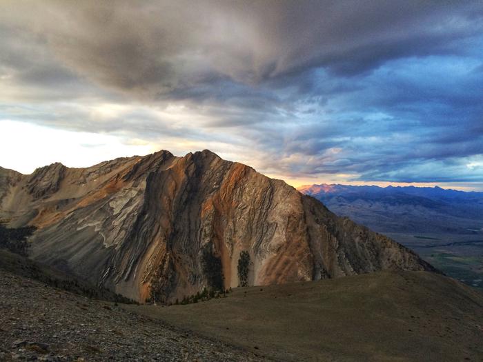
Salmon-Challis National Forest
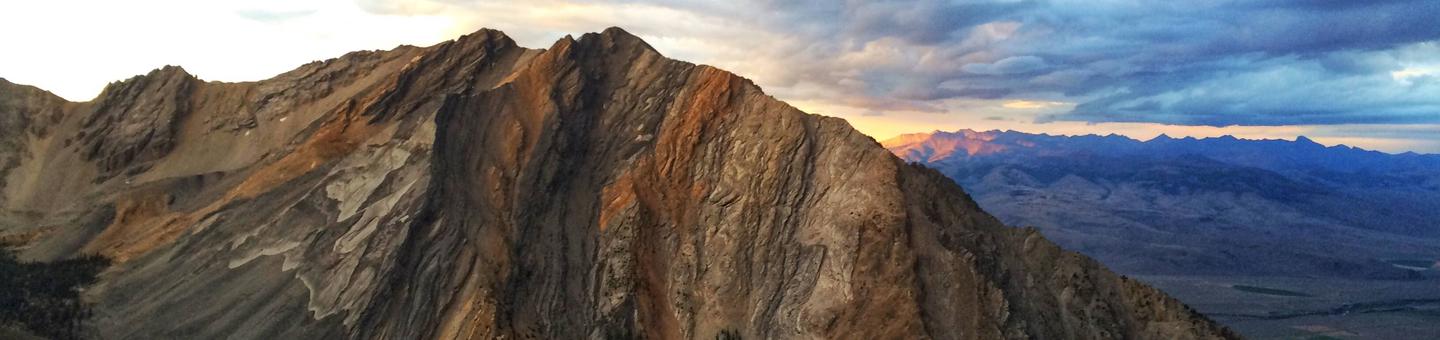
The Salmon-Challis National Forest is a land of rugged mountains split by untamed rivers. Escape into the backcountry in the Lemhi, Bitterroot, Pioneer, or Lost River Mountain Ranges. Visit the Bighorn Crags within the legendary Frank Church – River of No Return Wilderness and see a fantastic collection of granite peaks and alpine lakes. Raft the Wild & Scenic Rivers. Climb Idaho’s highest peak, Mount Borah. Relax at one of our campgrounds, or fish for trout or steelhead in our many lakes and streams. Enjoy miles of scenery while driving along Scenic Byways.
The forest is rich with America’s heritage. Historic cabins, ranger stations, lookouts, mining ghost towns, and the Lewis & Clark and the Nez Perce National Historic Trails link today’s visitor with the past. Visit the ghost town of Custer and tour the Yankee Fork Gold Dredge while travelling the Custer Motorway. Visit the Mackay Mine Hill to see a glimpse of the area’s copper mining legacy.
For more information about recreation activities, select one of the AREAS (divided into six Ranger Districts), or one of the RECREATION ACTIVITIES you want to do from the tool bar on the left, then view the opportunities within each of the Districts.
Heading out to go camping this weekend?
Thousands of bears live in our forests and mountains.
Hot Springs: The Salmon-Challis National Forest has many hotspring across the Forest. The water and pools associated with the springs may be near or above the boiling temperature and can cause severe, possibly even fatal, burns. PLEASE BE CAUTIOUS AND TEST THE WATER TEMPERATURE BEFORE YOU ENTER!!
RecAreaDirections
Open with Google Map
Misc
| Stay Limit | |
| Reservable | false |
| Keywords | |
| Map Link | |
| Contact Phone | |
| Contact Email |
Permits info
Facilities
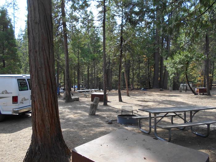
BOUNDARY CREEK CAMPGROUND Campground
List of CampsitesOverview
Boundary Creek Campground is located at the edge of the Frank Church River of No Return Wilderness, adjacent to the boat launch for the Middle Fork of the Salmon River in Idaho. The site generally provides overnight camping for boaters waiting to launch the next day on their permit to float the Middle Fork.
Of the 15 campsites, 5 can be reserved during the high-use season (June 15-Aug. 15); the remaining 10 are first-come, first-served. Outside of those dates, all 15 sites are first-come, first-served.
Recreation
Boundary Creek Campground is a popular spot for boaters running the Middle Fork of the Salmon. A nearby transfer camp provides long-term parking and trail access into the Frank Church River of No Return Wilderness. Visitors enjoy hiking, horseback riding, picnicking, fishing and viewing wildlife.Facilities
The campground offers 15 campsites, each equipped with a picnic table and campfire ring. Five of these sites are reservable during the peak season (June 15-August 15); the other 10 are available on a first-come, first-served basis. Vault toilets and drinking water are provided.
Natural Features
At an elevation of 6,280 feet, the campground is situated among lodgepole pine trees, near the Wild and Scenic Middle Fork of the Salmon River. The air is crisp and fresh, even in the heart of summer, due to it's high elevation.Nearby Attractions
The Middle Fork of the Salmon River flows over 100 miles through the heart of the Frank Church-River of No Return Wilderness, and originates 20 miles northwest of Stanley, Idaho, at the confluence of Bear Valley and Marsh Creeks. Float permits are required year round. It was one of the original eight rivers in the nation designated as Wild and Scenic on October 2, 1968.BONANZA CCC GROUP CAMPGROUND Campground
List of CampsitesOverview
Bonanza CCC Group Campground is located nine miles up the scenic and historic Yankee Fork drainage. It is approximately 23 miles from Stanley, Idaho, at an elevation of 6,500 feet.Recreation
The Yankee Fork provides good fishing for rainbow trout, cutthroat trout and whitefish.Many miles of trails crisscross the area, including the West Fork of Yankee Fork, Crimson Lake Trail and Lightning Creek Trail. Trailheads for each are not far from the campground.
Facilities
The site is available for reservation from Memorial Day through Labor Day, and is for group camping only. Individual units are not reservable.The campground includes 13 camp spurs; each with a pad for parking vehicles and/or trailers, a picnic table and a campfire ring. The facility also offers a group area with two large fire rings, a grey water sink and several picnic tables.
Camping spurs average from 45 to 50 feet deep. Five spurs are wide enough to accommodate one to two additional vehicles. The entire facility allows parking for approximately 40 vehicles without trailers and 20 vehicles with trailers. Please take this into consideration if your group brings trailers.
Vault toilets, potable water, and trash collection are provided, but there is no electricity or other hookups. Roads and parking spurs are gravel.
Natural Features
Bonanza is situated in a beautiful valley near the Yankee Fork of the Salmon River. Lodgepole pines are scattered throughout the campground, providing limited shade. Summer wildflowers are abundant in the area.Nearby Attractions
Yankee Fork has a rich history, all of which is easily accessed from the campground. Within a mile is the ghost town of Bonanza and two miles further is the ghost town of Custer. Bonanza, Boot Hill and Custer cemeteries are in the vicinity. The Yankee Fork Gold Dredge towers over the stream near Custer. Interpretive tours of the structure are offered from Memorial Day weekend through Labor Day. Sunbeam Dam site is nine miles down the canyon. Information about the only dam ever built on the Salmon River are provided at the river's edge.CAPE HORN WINTER RENTAL Campground
List of CampsitesOverview
Cape Horn Winter Rental is located in beautiful Elk Meadow, approximately 16 miles northwest of Stanley, in central Idaho. It sits at an elevation of 6,660 feet. Guests enjoy the area for its endless winter recreation opportunities, including cross-country skiing, back country downhill skiing, snowshoeing and snowmobiling.Recreation
The Cape Horn area offers unlimited cross-country skiing, snowshoeing, and snowmobiling opportunities in the surrounding meadows, and downhill skiing is available on the slopes behind the cabin. Click here for an Idaho OHV safety message.Facilities
The cabin is open for reservations during the winter only. In the summer, it is used by Forest Service employees as a guard station.The cabin can comfortably accommodate four people on one double bed and one single bed, each with mattresses, and one couch. More people can use sleeping bags on the floor, but due to the cabin's size, group size is limited to eight people. Guests need to bring their own food, toiletries, towels, bedding and trash bags.
The cabin is equipped with electricity, which powers the lights and a standard four-burner stove and oven, but due to heavy snowfall on power lines, electricity cannot be guaranteed at all times. Be prepared to cook meals on the wood stove if the power is out. Firewood is provided, though it may need to be split.
A table and chairs and additional seating is provided, along with a battery powered lantern and a wooden rack for drying clothes. The water system is turned off during the winter season so the indoor flush toilet and running water are not available. A vault toilet is located behind the station.
Natural Features
The cabin is situated in a stand of lodgepole pines. On clear days, the cabin's front porch affords breathtaking views of the rugged Sawtooth Mountain Range to the south.YELLOWJACKET GUARD STATION Campground
List of CampsitesOverview
Yellowjacket Guard Station is a historic Forest Service Ranger Station and Work Center. Originally constructed in 1925 and remodeled in 1934 by the Civilian Conservation Corps, the structure is eligible for listing on the National Register of Historic Places.Recreation
Hikers, horseback riders, mountain bikers and off-road enthusiasts will find many trails in the surrounding area. Hunting is also a popular activity. Click here for an Idaho OHV safety messageFacilities
The spacious guard station can sleep a maximum of three people in two bedrooms, with one full bed and one single bed. No linens or bedding are provided. The living room contains a couch, wood stove, table and chairs.
The small kitchen is equipped with a propane range/oven, a propane refrigerator and sink, but no running water. Guests must bring their own drinking water, as well as dishes, utensils and cookware.
The guard station is eqiuped with propane lights and an outhouse toilet that is located outside up a small hill.
Natural Features
The guard station sits in the Yellowjacket Mountains within the Salmon-Challis National Forest in Idaho. The sizable front porch awards views of the scenic mountain meadow surrounding the station. A dense conifer forest covers the mountains and a few aspens dot the landscape. Beagle Creek flows nearby.Nearby Attractions
Bighorn Crags, Frank Church River of No Return Wilderness Area and Panther Creek.LORISTICA GROUP CAMPGROUND Campground
List of CampsitesOverview
Loristica Group Campground is located in a wooded meadow high in the Lost Creek Range, in eastern Idaho. It sits at an elevation of 8,100 feet. Visitors come to the area for its great trail opportunities and scenic beauty.Recreation
Two trailheads can be accessed within a mile of the campground. The Bear-Wet Creek Trail is open to hiking, horseback riding and off-road vehicles.The Long Lost-Wet Creek Trail is a non-motorized trail leading to a high plateau with spectacular views of Little Lost and Big Mountain Ranges. Visitors should watch for bighorn sheep, deer and elk in the Big Creek area, along the trail.
Facilities
This rustic campground is a group reservation site that can accommodate up to 100 people among seven individual campsites. Though few amenities are present, picnic tables, fire rings and vault toilets are provided. An amphitheater with a campfire circle is also on-site.Natural Features
The campground is situated among Douglas fir, lodgepole pine and aspen trees. A variety of wildlife, including deer, elk, bears, foxes and coyotes, makes its home in the surrounding area.Salmon River (4 Rivers) Permit
Overview:
The Salmon River originates in the Sawtooth and Lemhi Valleys of central and eastern Idaho. Springs and snowmelt from the Sawtooth and Salmon River mountains feed this wild river.The river flows undammed along its 425-mile total length and drains about 14,000 square miles within the borders of Idaho. It is the longest free-flowing river in the lower 48 states. From elevations above 8,000 feet, the Salmon cascades to an elevation of 905 feet before it joins the Snake River in Hells Canyon, near the Idaho/Oregon border.
The Salmon River is historically known as The River of No Return. For more than 105 years after the first European Americans came to the area, only one-way trips down the river were possible. The most commonly used boats were wooden scows, designed to carry heavy loads and withstand whitewater. They were then dismantled and used for lumber at the trips' conclusion. It was from these trips that the Salmon's nickname, "River of No Return," originated.
Historically, wooden rafts, swimming, cable crossings, bridges or ferries were the only available means by which to cross the River of No Return. Today, there are pack bridges at Stoddard Trailhead, Campbells Ferry, Mackay Bar and Wind River.
The Salmon flows through a vast wilderness, as well as the second-deepest gorge on the continent. Only Hells Canyon in the Snake River is deeper. The Salmon's granite-walled canyon is over 1,000 feet deeper than the Grand Canyon. For approximately 180 miles, the Salmon River canyon is more than a mile deep.
In the 151 miles from North Fork to Riggins, the Salmon River drops a total of 1,910 feet, or more than 12 feet per mile. Peak flows occur from the middle of May to early July. The river is at its lowest in January and February, but highs and lows are subject to seasonal changes.
All boaters floating the wild section of the Salmon River are required to obtain a trip permit before launching at any time of the year. The section of river covered by this system extends from Corn Creek to Long Tom Bar. Boaters floating the South Fork of the Salmon River and exiting onto the wild section of the main Salmon must obtain a tributary permit before floating. South Fork floaters will need to contact the Krassel Ranger District at (208) 634-0616 for permit information.
Boating permits are required year-round. Outside the lottery season, the number of launches is unlimited, but a trip permit is required before launching. During the lottery season, a 21-day cancellation is required. Also during the lottery season, the size of the group determines the maximum length of stay.
The lottery period for the wild section of the main Salmon extends from June 20 through Sept. 7. During the lottery season, no more than eight float boat parties (commercial and non-commercial) are allowed to launch each day.
Middle Fork Of The Salmon (4 Rivers) Permit
Overview:
Welcome to the remote and rugged mountains and rivers of Central Idaho. Each year, approximately 10,000 people float the Middle Fork of the Salmon River. The Middle Fork is a 104-mile free-flowing river in the heart of the Frank Church River of No Return Wilderness, originating 20 miles northwest of Stanley, Idaho, at the confluence of Bear Valley and Marsh Creeks.It was one of the original eight rivers in the nation designated as Wild and Scenic on October 2, 1968. The river moves through a variety of climates and land types; from alpine forest to high mountain desert to sheer, rock-walled canyon, the third deepest in North America.
The Middle Fork is administered under a permit system to protect it from excessive human impacts. Part of that protection asks you, the user, to learn and practice Leave No Trace ethics. Because of its remote location, man's presence in the area was somewhat limited, leaving it in the condition we see today.
Only a few trails, landing strips, private ranches and Forest Service stations are evidence of man's intrusion. The Middle Fork is now an internationally recognized whitewater/wilderness float trip, known for its scenic beauty and crystal clear whitewater. It is a non-motorized floating experience with many technical rapids. These class III and IV+ rapids offer boating excitement for both families and experienced adventurers.
Hiking from the river campsites offers a taste of the wilderness experience and visitors may be lucky enough to catch a glimpse of how past inhabitants lived.
The Middle Fork of the Salmon River is usually not floated November 1 to March 31 due to winter conditions, low water levels and access difficulties. Ice and snow bridges are to be expected on the river and its tributaries during this time.
In the spring, road access to the Middle Fork is usually limited by snowdrifts and trees across the road. Depending on the amount of snow, spring weather and temperatures, the road to Boundary Creek may not open until sometime in early June. High water levels are also a concern once the runoff begins.
Bighorn Crags & Yellowjacket Recreation Areas Facility
xx
East Fork Area Facility
The district has several miles of trails in the East Fork of the Salmon River country. Access for these trails is generally from BLM lands. Please respect private property when recreating in this area.
Bayhorse - Squaw Creek Area Facility
This area is a popular destination for a variety of recreation uses. A partnership with the State Park at the historic Bayhorse Townsite provides ATV trail riding. Camping and fishing at the campgrounds at Bayhorse and Little Bayhorse Lakes draws visitors during the summer months.
Yankee Fork Drainage Facility
The Yankee Fork of the Salmon has a rich history in it's many uses by settlers and prospectors. Custer Townsite and the Yankee Fork Dredge are two major attractions. You can stay at one of many campgrounds in the area or enjoy both motorized and non-motorized trails.
Salmon-Cobalt Ranger District Facility
Salmon-Cobalt Ranger District
This Ranger District is expansive and takes in the Salmon river mountains and most of the forest that one can see from the town of Salmon. From boating at Williams Lake to hiking into the Frank Church - River of No Return Wilderness, there is a wide variety of activities to choose from when recreating in "Salmon's Backyard".
Challis Area Facility
The area around Challis provides many opportunities for day hikes and drives as well as camping and backpacking. You can check out the Land of the Yankee Fork Interpretive center just south of the town of Challis and start your tour of the Custer Motorway. You do not have to drive far from Challis to enjoy a variety of recreational activities!
Challis-Yankee Fork Ranger District Facility
The Challis-Yankee Fork Ranger District provides a multitude of opportunities for recreation year round. We are in the process of updating this site to provide you with the most current information. If you cannot find the information you need here, please call our offices at 208-879-4100 for assistance.
To assist you in planning your trip, we have divided the district into several areas they are:
- Basin-Vally Creek
- Bayhorse-Squaw
- Cape Horn
- Challis
- East Fork
- Pahsimeroi
- Upper Salmon River Road
If you click on "Find an Area" and then click on the plus arrow the the left of the "Challis-Yankee Fork Ranger District," you should see these areas and the trails and campgrounds within them.
Lost River Ranger District Facility
Lost River District
Iron Lake Campground Campground
List of CampsitesEight campsites with picnic tables and fire rings are along the shores of this high alpine lake. the campground has piped drinking water and vault toilets but no garbage services are available. The trail from campground leads to more lake fishing, at the Hat Lakes to the south. Carry-down access for non motorized boats to the lakes. The drive in along Salmon River Mountain Road, offers spectacular views of craggy peaks and deep pine forests.
Phi Kappa Campground Campground
List of CampsitesThe campground has 21 campsites in a beautiful wooded setting. Amenities include one handpump to provide potable water (the natural color of which is rusty), and two vault toilets. Water is only available during the summer months. Non-reservable campground with $10/night fee. Nearby areas of Interest are Kane Lake, Big Fall Creek Lake, Sun Valley/Ketchum Area.
Williams Lake Campground Campground
List of Campsites4500-foot elevation. Picnic area on Williams Lake, with the trailhead to 2 walk-in or boat-in campsites. The picic area and fishing area are both fully accessible. Five tables with connecting walkways overlook scenic vistas of the lake and surrounding mountains. Fishing for rainbow trout in the lake, and fantastic fly fishing in the inlet. Trailhead for Thunder Mountain National Historic Trail at the end of FR 028. Ice fishing in the winter. Full-service resort on south shore of the lake includes a tackle shop and restaurant.
Wallace Lake Campground Campground
List of Campsites12 campsites on Wallace Lake with picnic tables and fire rings. Within the campground are vault toilets and drinking water. Fishing in the lake. Primitive boat launch can be used for non-motorized canoes or rowboats on the lake. The drive on Salmon River Mountain Road offers fantastic views of the Salmon River Range and of deep pine forests.
Banner Creek Campground Campground
List of CampsitesA nice campground along Highway 21 in the trees with a small creek running through. Campground has 5 campsites with picnic tables and fire rings with cooking grills. The campground amemities include a vault toilet. No drinking water is available and the campground is limited to trailers and motorhomes up to 32 feet long; there are no hookups within the campground.
Thatcher Campground Campground
List of CampsitesThis campground is just off Highway 21, and tucked back into the trees, overlooking beautiful Capehorn meadows. Walk across the street to overlook a marshy wetland, a hangout for breakfasting moose, elk, and a variety of birds. Each of the 5 sites is equipped with picnic tables and fire rings with cooking grills. The campground accommodates trailers and motorhomes up to 32 feet and has vault toilets and hand pumps for drinking water. Although there are no full hookups, the campground will fit trailers and RV's up to 32 feet long.
Pole Flat Campground Campground
List of CampsitesThis campground is away from the main road and up the hill overlooking the river and the dredge ponds. Campsites include picnic tables tent pads fire rings with cooking grills. Campground amenities include a vault toilet and drinking water. Sites accommodate trailers and motorhomes up to 32 feet long.
Custer #1 Campground Campground
List of CampsitesThis campground is along the Custer Motorway just above the townsite of Custer, a boom town during the late 1800's. Visit the museum, open 9 - 5 Memorial Day through Labor Day. Facilities include 6 sites with picnic tables and fire rings with cooking grills. Campground has a vault toilet and can accommodate trailers and motorhomes up to 32 feet long.
Leadore Ranger District Facility
Leadore Ranger District
Squaw Creek Trailhead Facility
This trailhead provides access to both the Yankee Fork and Bayhorse areas through the trail system. There is very little development; only mangers for stock and rock firerings. There is no toilet or drinking water here.
Basin Creek Transfer Camp Trailhead Facility
This trailhead has hitching rails and dispersed campsites. No toilet or drinking water is available.
Lower Basin Trail #4349, begins at this point. It connects with several other trails in the Basin Creek area
Squib Trailhead Facility
This is a rustic trailhead with few amenities. There is a multi-vehicle parking area with an information board. There are two hardened sites at the trailhead.
Reynolds Trailhead Facility
Reynolds CUA Trailhead
Eleven Mile Trailhead Facility
This site has a toilet and hitching rails.
Newland Ranch Dump Station Facility
This site has a bathroom, an RV dump station, garbage dumpsters, and a SCAT machine for washing portable toilet systems.
Morgan Summit Trailhead Facility
Morgan Summit Trailhead
Buster Lake Trailhead Facility
This is the trailhead for trail #4153, Fanny's Hole and #4152, Buster Lake Trail. There is one campsite above Buster Lake available for overnight camping. The road is narrow and steep; 4wd recommended.
West Fork Upper Pahsimeroi Trailhead Facility
This trailhead has minimal development, providing access to Merriam and Pass Lake Trails. One metal firering, a picnic table and a two-sided latrine are on site.
Twin Peaks Transfer Camp Facility
Twin Peaks Trailhead sits in the saddle between Twin Peaks. There is an unloading ramp as well as hitch rails and informational signing for the Frank Church RNR Wilderness Area.
Trail #4104, Warm Springs is accessed from this site.
Rapid River Trailhead Facility
Trailhead for trail #4007 Rapid River.
Phillips Creek Transfer Camp Trailhead Facility
This transfer camp provides access to Loon Creek Trail #4101.
Cache Bar Boat Ramp Facility
Cache Bar is the primary take-out ramp for rafters leaving the Middle Fork of the Salmon River.
Clear Creek Trailhead Facility
Clear Creek Trailhead
Williams Lake Day Use Area Facility
Williams Lake Recreation Site
Williams Creek Picnic Site Facility
Picnic Site
Long Tom Picnic Picnic Area Facility
Picnic Area
Newland Ranch Picnic Site Facility
Newland Ranch Picnic Site
Stoddard Trailhead Facility
The Stoddard Pack Bridge is closed - this is the main access point for the Stoddard Trailhead
Williams Creek Summit Trailhead Facility
Trailhead
West Fork Transfer Camp Trailhead Facility
This trailhead offers a vault toilet, hitching rails and dispersed campsites.
Marsh Creek Transfer Camp Trailhead Facility
This trailhead provides access for the Marsh Creek Trail #4237, the Bear Valley-Marsh Creek Trail #4010, and the Middle Fork Trail #001.
Beaver Creek Transfer Camp Trailhead Facility
Beaver Creek Trailhead provides access to Wilderness trails in the Cape Horn area. Trail #4021 South Fork of Fall Creek is accessed from this trailhead (this trail is also referred to as Halstead Creek).
Banner Summit Rest Stop Facility
This rest stop also has two picnic tables for travelers to enjoy a picnic.
Asher Knapp Transfer Camp Trailhead Facility
Trailhead for the Knapp-Loon Creek Trail #4036 in the Cape Horn area.
Pahsimeroi Area Facility
The Pahsimeroi and Lemhi Mountains provide the setting for some amazing recreational opportunities. There are two small campgrounds and numerous trails to enjoy.
Upper Salmon River Road Access Facility
These trails are accessed from Highway 75, generally between the towns of Clayton and Sunbeam.
Bannock Pass - CDT Access Facility
This historic pass through the Beaverhead mountains has long been a travel route between the Lemhi River Valley and Horse Prairie.
Beaverhead Mountain Range - South Facility
xx
Lewis and Clark Back Country Byway Facility
Almost 200 years ago Meriwether Lewis and William Clark stood high on a ridge-line that divides the continental waters and began the discovery of the Pacific Northwest. Welcome to the homeland of Sacajawea.
Stands of fir and pine trees, high-mountain meadows and rolling, jade-colored hills look much the same today as when the famous explorers journeyed to the crest of Lemhi Pass in 1805.
As you travel the Lewis and Clark Back Country Byway, you'll experience spectacular vistas overlooking the homeland of the Native American Shoshone. Gaze westward from Lemhi Pass upon the immense Salmon River and Rocky and Lost River mountain ranges. The pine and fir forests, deep canyons, and rolling foothills look much the same today as when the Lewis and Clark Expedition crossed Lemhi Pass two centuries ago.
Williams Lake Recreation Area Facility
xx
Beaverhead Mountain Range - North Facility
xx
Lemhi Mountain Range Facility
xx
Bitterroot Mountain Range - Idaho Facility
This area encompasses trails, campgrounds, and trail heads with access points located between the Salmon River and the Montana border and I-93 North to the Frank Church - River of No Return Wilderness border. This area is also known as the Bitterroot Mountain Range which divides Idaho from Montana.
Main Salmon River Road - North Fork Facility
This area encompasses Boat ramps, Campgrounds, and Trailheads that are located on the 47 mile stretch of road between I-93 North in North Fork, ID and the Corn Creek Launch Site (doorway to the Frank Church - River of No Return Wilderness).
Sleeping Deer Area (MF1) Facility
This area encompasses trails, trailheads, and other recreation options originating mainly around the Sleeping Deer Road #086, a “cherry-stem” road west of Twin Peaks Saddle that is surrounded by the Frank Church--River of No Return Wilderness. This area is roughly bordered on the east by Camas Creek and Meyers Cove, by Loon Creek and Warm Springs to the west, the wilderness boundary to the south, and the Middle Fork of the Salmon River to the north. This area has seen a lot of fire activity over the years.
The Sleeping Deer Road is a single-track, high-elevation dirt road that opens late and closes early due to snow.
Mount Borah Area Facility
This area has the Mount Borah Climbing Trail and Developed trailhead, the Earthquake Interpretive Site and the Leatherman Pass Trail.
Wildhorse Canyon Area Facility
This area includes the Wildhorse Developed campground and numerous trails in the vicinity of Wildhorse Guard Station.
Loon Creek Area (MF2) Facility
This area encompasses trails, trailheads, camping and other recreation sites surrounding the Beaver-Loon Road #172, the Loon Creek Road #007 and the Indian Springs Road #004. This area is roughly bordered by the Middle Fork of the Salmon River to the north, Loon Creek and Warm Springs Creek to the east, the Wilderness boundary to the south, and the Seafoam country on the west.
Access roads are single-track dirt roads with high-elevation passes that are closed by snow during the winter. The Indian Springs Road #004 is steep, narrow, rough, and does not receive annual maintenance. There is a backcountry dirt airstrip (Upper Loon) near the end of the Loon Creek Road and near Tin Cup Campground and the Phillips Creek Trailhead.
Cape Horn Area (MF6) Facility
This area generally encompasses trails, trailheads, campgrounds and other recreation opportunities in the Cape Horn Country that are outside the Wilderness boundary. Campgrounds in this area include Lola, Beaver, Banner, Bench and Thatcher, just off Highway 21, plus Vader Rest Stop. In the winter, the Cape Horn Guard Station may be rented.
Seafoam, Marsh Cr., Langer & Soldier Area (MF3) Facility
This area encompasses trails, trailheads, camping and other recreation sites that are generally accessed from the Seafoam area on the Middle Fork Ranger District. The Seafoam “bubble” is non-wilderness and contains the Josephus Campground and trailhead for the Soldier Lakes area. Be aware of the Wilderness boundaries.
Boundary, Sulphur, Pistol, Indian Creek Area (MF4) Facility
This area encompasses trails, trailheads, camping and other recreation opportunities on the District that are generally reached from or near the Dagger-Boundary Road #568, the Artillery Dome Road #550, or other roads/routes along the western wilderness boundary.
There are two campgrounds, Boundary Creek and Dagger Falls, in this area. Boundary Creek is a popular campground for boaters beginning their float trips on the Middle Fork of the Salmon River. The Transfer Camp is a trailhead for the Middle Fork Trail and a long-term parking area for boaters.
Marble, Sheep and Brush Creek Area (MF5) Facility
This area generally encompasses trails, trailheads, camping and other recreation opportunities that are west/northwest of the Middle Fork of the Salmon River. It is roughly bordered by the river on the south and east, Marble Creek to the west, and the Payette National Forest to the north.
TWIN CREEK CAMPGROUND GROUP CAMPING SITE Campground
List of CampsitesOverview
Twin Creek Group Camping Site is part of the larger Twin Creek Campground. This beautiful campsite is located 15 miles north of North Fork, Idaho, and is situated along Twin Creek at an elevation of 5,100 feet.Recreation
The recreational opportunities are abundant in this corner of the Salmon-Challis National Forest. There are fishing opportunities in the North Fork of the Salmon River and in Twin Creek. For the hikers, there are numerous trails in the area but trails #6108 and #6109 are located just behind the campground (pick up a visitor map or contact the North Fork District Office for more information). During certain parts of the year berry picking can be excellent around the campground.Facilities
Twin Creek Campground Group Camping Site has numerous amenities including a large parking area (for multiple vehicles and or trailers), a double vault toilet, drinking water, four picnic tables (two of which are extra-long), a large fire ring, multiple barbeque pedestals, a large barbeque pit, a historic pavilion with a picnic table and benches, and two horseshoe pits. Electricity and water/sewer hookups are not available at this site/campground.Natural Features
Twin Creek Campground Group Camping Site is located in the Twin Creek drainage near its confluence with the North Fork of the Salmon River. Large pine trees and brush surround the campsite offering plenty of shade and privacy.Nearby Attractions
While you are in the area be sure to check out the beautiful Salmon River, located 15 south of the campsite. Also, brush up on some history and imagine you are Lewis and Clark as you travel along Highway 93, which contains portions of the Lewis and Clark National Historic Trail.COPPER BASIN GUARD STATION Campground
List of CampsitesOverview
Copper Basin Guard Station is located in Copper Basin, a rugged and beautiful area in the Pioneer Mountains of south-central Idaho.Recreation
Copper Basin offers many recreational opportunities. These include stream and lake fishing, day hikes to high mountain lakes, mountain bike riding, hiking, horseback riding, camping, photography, hunting, off-highway vehicle (OHV) riding, birding, viewing wildlife, and driving for pleasure.Facilities
The Copper Basin Guard Station is a 900 square foot, two bedroom log cabin that can sleep up to six adults comfortably, with room for eight people total. The cabin comes furnished with one queen bed with mattress, two full sized bunk beds with mattresses, and a queen sized sleeper couch in the living room. Other amenities include a propane cook stove, propane refrigerator, propane furnace, propane lights, wood stove, table with benches and chairs, table settings for eight, kitchen tools and cleaning supplies. The bathroom has hot and cold running water, a flush toilet, and a shower.The Copper Basin Guard Station has no electricity, phone service, cell coverage, or internet service. All appliances are powered by propane. Guests need to bring their own food, toiletries, towels, bedding and trash bags. There is no smoking, no candles, and no garbage service. No pets allowed in the cabin. Campfires are allowed only in the metal fire ring that is provided.
Natural Features
Copper Basin is a remote mountain valley with beautiful views, wide open spaces, and mountains in every direction. The Basin is surrounded by both the Pioneer and White Knob mountain ranges, with elevations between 7,500' - 8,000'. Copper Basin has abundant wildlife, numerous streams, and stunning mountain peaks.Nearby Attractions
Nearby attractions include fishing in the East Fork of the Big Lost River, OHV riding on the Lake Creek Trail, hiking on the Bellas Trail, and horseback riding on the Broad Canyon Trail.Copper Basin Area Facility
road 138
Antelope Canyon Area Facility
This is the area in and around Antelope Canyon, and can be accessed by Road #137.
Sawmill Canyon Area Facility
This area can be accessed by Road #101.
Mackay Mine Hill Area Facility
This is the area directly above the town of Mackay that contains the historic White Knob Mining District
Pass Creek Area Facility
This is the area in and around Pass Creek, which can be accessed by Road #122.
Lemhi's Area Facility
These are the areas located in the Lemhi Mountain Range south of Sawmill Canyon.
North Fork of the Big Lost River Area Facility
This is the area surrounding the North Fork tributary of the Big Lost River. This area can be accessed by the North Fork Road (#128), which is located off the Trail Creek Road (#128).
MEADOW LAKE CAMPGROUND Campground
List of CampsitesOverview
Meadow Lake Campground is located on the Leadore Ranger District of the Salmon-Challis National Forest. This high alpine campground sits at an elevation of 9,160 feet in the Lemhi Mountain Range, 22 miles from Leadore, Idaho.Recreation
There's no lack of recreational opportunities around Meadow Lake Campground. The lake is stocked twice a year so the fish are always biting. Fish from the bank or carry your boat down to the lake and try from the water, as there is no boat ramp or boat dock at the lake.
Hiking opportunities are available right out of the campground and include trail # 342 which provides a gentle loop around the backside of the campground. Try trail # 057 which takes you up to the steep ridge above the campground (the trail to Meadow Lake Peak is not maintained by the Forest Service).
If a slower pace is appealing, pull up a chair and soak-up the incredible views from the campground.
Facilities
Meadow Lake Campground consists of 17 campsites and a day use area with picnic tables, fire rings and barbecue pedestals. The campground offers 2 vault toilets, drinking water and day use parking. 4 double campsites are available for larger groups with each site including 2 picnic tables, 2 tent pads, a campfire ring, a prep table, and expanded parking for 2 vehicles. The campground also offer 13 single campsites each with a picnic table, tent pad, campfire ring, prep table, and parking for 1 vehicle.Natural Features
Meadow Lake Campground is located at the base of the 10,720-foot Meadow Lake Peak and along the banks of the 13.3-acre Meadow Lake. The high elevation campground is dotted with lodge pole pine and white bark pine trees and is frequented by deer and mountain goats.Nearby Attractions
There are plenty of other attractions in the vicinity of Meadow Lake including the Gilmore Ghost Town and a number of other Forest Service recreation sites and trails. Stop at the Leadore Ranger Station and pick up a visitor map for more information.Charges & Cancellations
A $8.00 non-refundable on line reservation fee may be charged for some facilities.Arco Pass Area Facility
This area encompasses the King Mountain Launch Site and the Natural Arch.
Cove Creek Boating Site Facility
Boating access point.
Basin - Valley Cr. Area Facility
This area encompases trails and trailheads in the Basin Creek, Basin Butte and Valley Creek area that are on the Challis-Yankee Fork Ranger District. Joe's Gulch and Kelly creek area are also here.
