
Sawtooth National Forest
Welcome to the Sawtooth National Forest. The Sawtooth National Forest is a place remarkable beauty that has been providing goods and services to the American people since its eastablishment in 1905. This 2.1 million acre forest is situated in south central Idaho and extends into northern Utah. Read Full Article
RecAreaDirections
Open with Google Map
Misc
| Stay Limit | |
| Reservable | false |
| Keywords | |
| Map Link | |
| Contact Phone | |
| Contact Email |
Permits info
Facilities
Caribou Campground Campground
List of CampsitesOverview
This location is available on a first-come, first-served basis only. Visitors are required to physically arrive at the campground to purchase and claim a site. Once on-site, you may be able to pay for your campsite(s) by scanning a QR code using the Recreation.gov mobile app, and the Scan and Pay feature.
If this option is available, you will need to first download the free Recreation.gov mobile app https://www.recreation.gov/mobile-app prior to your arrival as some remote areas have limited or no cellular service.
Casino Creek Campground
List of CampsitesChinook Bay Campground Campground
List of CampsitesOverview
This location is available on a first-come, first-served basis only. Visitors are required to physically arrive at the campground to purchase and claim a site. Once on-site, you may be able to pay for your campsite(s) by scanning a QR code using the Recreation.gov mobile app, and the Scan and Pay feature.
If this option is available, you will need to first download the free Recreation.gov mobile app https://www.recreation.gov/mobile-app prior to your arrival as some remote areas have limited or no cellular service.
Grandjean Campground Campground
List of CampsitesOverview
This location is available on a first-come, first-served basis only. Visitors are required to physically arrive at the campground to purchase and claim a site. Once on-site, you may be able to pay for your campsite(s) by scanning a QR code using the Recreation.gov mobile app, and the Scan and Pay feature.
If this option is available, you will need to first download the free Recreation.gov mobile app https://www.recreation.gov/mobile-app prior to your arrival as some remote areas have limited or no cellular service.
Holman Creek Campground Campground
List of CampsitesOverview
This location is available on a first-come, first-served basis only. Visitors are required to physically arrive at the campground to purchase and claim a site. Once on-site, you may be able to pay for your campsite(s) by scanning a QR code using the Recreation.gov mobile app, and the Scan and Pay feature.
If this option is available, you will need to first download the free Recreation.gov mobile app https://www.recreation.gov/mobile-app prior to your arrival as some remote areas have limited or no cellular service.
Iron Creek Campground (ID) Campground
List of CampsitesOverview
This location is available on a first-come, first-served basis only. Visitors are required to physically arrive at the campground to purchase and claim a site. Once on-site, you may be able to pay for your campsite(s) by scanning a QR code using the Recreation.gov mobile app, and the Scan and Pay feature.
If this option is available, you will need to first download the free Recreation.gov mobile app https://www.recreation.gov/mobile-app prior to your arrival as some remote areas have limited or no cellular service.
Lower O'Brien Campground Campground
List of CampsitesOverview
This location is available on a first-come, first-served basis only. Visitors are required to physically arrive at the campground to purchase and claim a site. Once on-site, you may be able to pay for your campsite(s) by scanning a QR code using the Recreation.gov mobile app, and the Scan and Pay feature.
If this option is available, you will need to first download the free Recreation.gov mobile app https://www.recreation.gov/mobile-app prior to your arrival as some remote areas have limited or no cellular service.
Mormon Bend Campground Campground
List of CampsitesOverview
This location is available on a first-come, first-served basis only. Visitors are required to physically arrive at the campground to purchase and claim a site. Once on-site, you may be able to pay for your campsite(s) by scanning a QR code using the Recreation.gov mobile app, and the Scan and Pay feature.
If this option is available, you will need to first download the free Recreation.gov mobile app https://www.recreation.gov/mobile-app prior to your arrival as some remote areas have limited or no cellular service.
Mount Heyburn Campground Campground
List of CampsitesOverview
This location is available on a first-come, first-served basis only. Visitors are required to physically arrive at the campground to purchase and claim a site. Once on-site, you may be able to pay for your campsite(s) by scanning a QR code using the Recreation.gov mobile app, and the Scan and Pay feature.
If this option is available, you will need to first download the free Recreation.gov mobile app https://www.recreation.gov/mobile-app prior to your arrival as some remote areas have limited or no cellular service.
Mountain View Campground (ID) Campground
List of CampsitesOverview
This location is available on a first-come, first-served basis only. Visitors are required to physically arrive at the campground to purchase and claim a site. Once on-site, you may be able to pay for your campsite(s) by scanning a QR code using the Recreation.gov mobile app, and the Scan and Pay feature.
If this option is available, you will need to first download the free Recreation.gov mobile app https://www.recreation.gov/mobile-app prior to your arrival as some remote areas have limited or no cellular service.
Murdock Campground Campground
List of CampsitesOverview
This location is available on a first-come, first-served basis only. Visitors are required to physically arrive at the campground to purchase and claim a site. Once on-site, you may be able to pay for your campsite(s) by scanning a QR code using the Recreation.gov mobile app, and the Scan and Pay feature.
If this option is available, you will need to first download the free Recreation.gov mobile app https://www.recreation.gov/mobile-app prior to your arrival as some remote areas have limited or no cellular service.
North Shore Campground Campground
List of CampsitesOverview
This location is available on a first-come, first-served basis only. Visitors are required to physically arrive at the campground to purchase and claim a site. Once on-site, you may be able to pay for your campsite(s) by scanning a QR code using the Recreation.gov mobile app, and the Scan and Pay feature.
If this option is available, you will need to first download the free Recreation.gov mobile app https://www.recreation.gov/mobile-app prior to your arrival as some remote areas have limited or no cellular service.
Pettit Lake Campground Campground
List of CampsitesOverview
This location is available on a first-come, first-served basis only. Visitors are required to physically arrive at the campground to purchase and claim a site. Once on-site, you may be able to pay for your campsite(s) by scanning a QR code using the Recreation.gov mobile app, and the Scan and Pay feature.
If this option is available, you will need to first download the free Recreation.gov mobile app https://www.recreation.gov/mobile-app prior to your arrival as some remote areas have limited or no cellular service.
Riverside Campground (ID) Campground
List of CampsitesOverview
This location is available on a first-come, first-served basis only. Visitors are required to physically arrive at the campground to purchase and claim a site. Once on-site, you may be able to pay for your campsite(s) by scanning a QR code using the Recreation.gov mobile app, and the Scan and Pay feature.
If this option is available, you will need to first download the free Recreation.gov mobile app https://www.recreation.gov/mobile-app prior to your arrival as some remote areas have limited or no cellular service.
Salmon River Campground Campground
List of CampsitesOverview
This location is available on a first-come, first-served basis only. Visitors are required to physically arrive at the campground to purchase and claim a site. Once on-site, you may be able to pay for your campsite(s) by scanning a QR code using the Recreation.gov mobile app, and the Scan and Pay feature.
If this option is available, you will need to first download the free Recreation.gov mobile app https://www.recreation.gov/mobile-app prior to your arrival as some remote areas have limited or no cellular service.
Smokey Bear Campground Campground
List of CampsitesOverview
This location is available on a first-come, first-served basis only. Visitors are required to physically arrive at the campground to purchase and claim a site. Once on-site, you may be able to pay for your campsite(s) by scanning a QR code using the Recreation.gov mobile app, and the Scan and Pay feature.
If this option is available, you will need to first download the free Recreation.gov mobile app https://www.recreation.gov/mobile-app prior to your arrival as some remote areas have limited or no cellular service.
Sockeye Campground Campground
List of CampsitesOverview
This location is available on a first-come, first-served basis only. Visitors are required to physically arrive at the campground to purchase and claim a site. Once on-site, you may be able to pay for your campsite(s) by scanning a QR code using the Recreation.gov mobile app, and the Scan and Pay feature.
If this option is available, you will need to first download the free Recreation.gov mobile app https://www.recreation.gov/mobile-app prior to your arrival as some remote areas have limited or no cellular service.
Upper O'Brien Campground Campground
List of CampsitesOverview
This location is available on a first-come, first-served basis only. Visitors are required to physically arrive at the campground to purchase and claim a site. Once on-site, you may be able to pay for your campsite(s) by scanning a QR code using the Recreation.gov mobile app, and the Scan and Pay feature.
If this option is available, you will need to first download the free Recreation.gov mobile app https://www.recreation.gov/mobile-app prior to your arrival as some remote areas have limited or no cellular service.
Whiskey Flat Campground Campground
List of CampsitesOverview
This location is available on a first-come, first-served basis only. Visitors are required to physically arrive at the campground to purchase and claim a site. Once on-site, you may be able to pay for your campsite(s) by scanning a QR code using the Recreation.gov mobile app, and the Scan and Pay feature.
If this option is available, you will need to first download the free Recreation.gov mobile app https://www.recreation.gov/mobile-app prior to your arrival as some remote areas have limited or no cellular service.
BOUNDARY (ID) Campground
List of CampsitesOverview
This location is available on a first-come, first-served basis only. Visitors are required to physically arrive at the campground to purchase and claim a site. Once on-site, you may be able to pay for your campsite(s) by scanning a QR code using the Recreation.gov mobile app, and the Scan and Pay feature.
If this option is available, you will need to first download the free Recreation.gov mobile app https://www.recreation.gov/mobile-app prior to your arrival as some remote areas have limited or no cellular service.
DIAMONDFIELD JACK CAMPGROUND Campground
List of CampsitesOverview
This location is available on a first-come, first-served basis only. Visitors are required to physically arrive at the campground to purchase and claim a site. Once on-site, you may be able to pay for your campsite(s) by scanning a QR code using the Recreation.gov mobile app, and the Scan and Pay feature.
If this option is available, you will need to first download the free Recreation.gov mobile app https://www.recreation.gov/mobile-app prior to your arrival as some remote areas have limited or no cellular service.
Lake Cleveland Campground - West Side Campground
List of CampsitesOverview
This location is available on a first-come, first-served basis only. Visitors are required to physically arrive at the campground to purchase and claim a site. Once on-site, you may be able to pay for your campsite(s) by scanning a QR code using the Recreation.gov mobile app, and the Scan and Pay feature.
If this option is available, you will need to first download the free Recreation.gov mobile app https://www.recreation.gov/mobile-app prior to your arrival as some remote areas have limited or no cellular service.
PETTIT CAMPGROUND Campground
List of CampsitesOverview
This location is available on a first-come, first-served basis only. Visitors are required to physically arrive at the campground to purchase and claim a site. Once on-site, you may be able to pay for your campsite(s) by scanning a QR code using the Recreation.gov mobile app, and the Scan and Pay feature.
If this option is available, you will need to first download the free Recreation.gov mobile app https://www.recreation.gov/mobile-app prior to your arrival as some remote areas have limited or no cellular service.
SCHIPPER CAMPGROUND Campground
List of CampsitesOverview
This location is available on a first-come, first-served basis only. Visitors are required to physically arrive at the campground to purchase and claim a site. Once on-site, you may be able to pay for your campsite(s) by scanning a QR code using the Recreation.gov mobile app, and the Scan and Pay feature.
If this option is available, you will need to first download the free Recreation.gov mobile app https://www.recreation.gov/mobile-app prior to your arrival as some remote areas have limited or no cellular service.
STEER BASIN CAMPGROUND Campground
List of CampsitesOverview
This location is available on a first-come, first-served basis only. Visitors are required to physically arrive at the campground to purchase and claim a site. Once on-site, you may be able to pay for your campsite(s) by scanning a QR code using the Recreation.gov mobile app, and the Scan and Pay feature.
If this option is available, you will need to first download the free Recreation.gov mobile app https://www.recreation.gov/mobile-app prior to your arrival as some remote areas have limited or no cellular service.
Twin Lakes Campground (Sawtooth) Campground
List of CampsitesOverview
This location is available on a first-come, first-served basis only. Visitors are required to physically arrive at the campground to purchase and claim a site. Once on-site, you may be able to pay for your campsite(s) by scanning a QR code using the Recreation.gov mobile app, and the Scan and Pay feature.
If this option is available, you will need to first download the free Recreation.gov mobile app https://www.recreation.gov/mobile-app prior to your arrival as some remote areas have limited or no cellular service.
UPPER PENSTEMON CAMPGROUND Campground
List of CampsitesOverview
This location is available on a first-come, first-served basis only. Visitors are required to physically arrive at the campground to purchase and claim a site. Once on-site, you may be able to pay for your campsite(s) by scanning a QR code using the Recreation.gov mobile app, and the Scan and Pay feature.
If this option is available, you will need to first download the free Recreation.gov mobile app https://www.recreation.gov/mobile-app prior to your arrival as some remote areas have limited or no cellular service.
ALTURAS LAKE PICNIC AREA (ID) Campground
List of CampsitesOverview
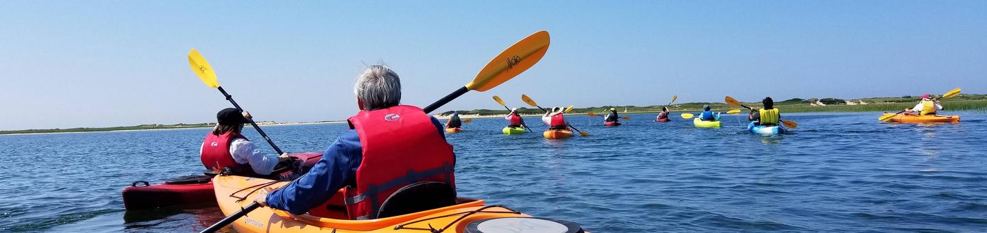
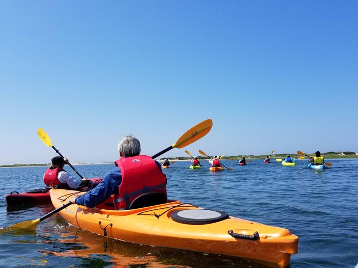
Alturas Area Picnic B is located along the sandy shoreline of scenic Alturas Lake, at the foot of the Sawtooth Mountain Range.Recreation
The site is part of the Sawtooth National Recreation Area, where outdoor activities abound. Alturas Lake offers excellent boating, water skiing, canoeing, kayaking and fishing for bull trout and Kokanee salmon. Alturas Creek runs through the adjacent campground.The 10-mile round trip Alpine Meadows Trail begins nearby, with spectacular canyon, meadow and alpine lake views. The trail is also a popular area for bird watching.
Facilities
The picnic site is a day-use area only. It offers one accessible group site that can accommodate up to 50 people. Vault toilets, drinking water and garbage service are provided. Smokey Bear Boat Ramp is less than 1/4-mile away.Natural Features
Summer wildflowers are plentiful, and a mixed-growth conifer forest provides partial shade. Temperatures are cool with an average summer high of 78 degrees and a low of 40 degrees.Nearby Attractions
The Sawtooth National Recreation Area offers a myriad of excellent hiking and biking opportunities, and an estimated 750 miles of trails crisscross the valley and surrounding mountains.Perkins Lake is less than 2 miles away, with excellent fishing and canoeing. Pettit and Yellowbelly Lakes are nearby with more fishing, canoeing and hiking. The Salmon River offers fishing for rainbow trout, Westslope cutthroat trout and occasional hybrid cutbows and bull trout.
Popular area events include an Arts and Crafts Fair in July, and Wagon Days, Salmon Festival, Quilt Fair and Fireman's Ball in September.
CHEMEKETAN CAMPGROUND Campground
List of CampsitesOverview
Chemeketan Campground sits near the headwaters of the Salmon River, at the foot of the Sawtooth Mountain Range.Recreation
This site is part of the Sawtooth National Recreation Area, where outdoor activities abound. The Salmon River offers excellent fishing for rainbow trout, westslope cutthroat trout and occasional hybrid cutbows and bull trout. The Idaho Centennial Trail can be easily accessed nearby.Alturas, Perkins, Pettit and Yellowbelly Lakes are nearby, with fishing, canoeing and hiking.
Facilities
This campground is reached via dirt road, however visitors must ford a stream before reaching the site. Trucks, RVs and cars with higher clearance should have no trouble crossing the stream.The campground offers one group site than can accommodate up to 150 people. If it is not reserved, it is available as a group site or individual sites on a first come, first served basis.
Vault toilets, tables and grills are provided.
Natural Features
Chemeketan is a secluded, peaceful campground situated among lodgepole pines, which provide partial shade. Rugged peaks of the Sawtooth Range surround the area and the Salmon River flows at the campground's edge. Temperatures are cool, with an average summer high of 78 degrees and a low of 40 degrees.Nearby Attractions
The Sawtooth National Recreation Area offers a myriad of excellent hiking and biking opportunities, and an estimated 750 miles of trails crisscross the valley and surrounding mountains.Popular area events include an Arts and Crafts Fair in July, and Wagon Days, Salmon Festival, Quilt Fair and Fireman's Ball in September.
EASLEY CAMPGROUND Campground
List of CampsitesOverview
Easley Campground is located along the beautiful Big Wood River at an elevation of 6800 feet, conveniently close to Ketchum, Idaho only 14 miles south. Visitors enjoy fishing, hiking and soaking at Easley Hot Springs.Recreation
Easley is part of the Sawtooth National Recreation Area, where outdoor activities abound. Fly-fishing for rainbow, brown and brook trout is popular on the Big Wood River, as is float tubing.The 20-mile Harriman Trail passes through the campground, offering excellent hiking and biking. Numerous trails spur off the Harriman Trail leading to deep canyons, sparkling lakes, swimming holes and more great high country fishing.
Facilities
The campground offers several family campsites, most of which have scenic views of the Boulder Mountains to the east. Vault toilets and drinking water are provided, but there is no electricity. Roads and parking spurs are gravel.Natural Features
A forest of Douglas fir, ponderosa pine, lodgepole pine and aspen offers plentiful shade in the campground. Colorful summer wildflowers are abundant and willows dot the banks of the river. Temperatures are cool with an average summer high of 78 and a low of 40.Nearby Attractions
Easley Hot Springs is less than 1/4-mile away, just past the campground entrance. A swimming pool, hot tubs and showers are available for a small fee, and a small store is located on-site.The Sawtooth National Recreation Area Visitor Center is 6.5 miles from the campground, with a small museum, bookstore and area information. A dump station and drinking water are located here as well.
Sun Valley Resort is 11 miles away, with hiking, biking, guided horseback riding and beautiful mountain scenery.
Popular area events include Wagon Days in Ketchum in September, and in Stanley an hour away, an Arts & Crafts Fair in July, and Salmon Festival, Quilt Fair and Fireman's Ball in September.
ELK CREEK CAMPGROUND (SAWTOOTH NF) Campground
List of CampsitesOverview
Elk Creek Campground lies just off Highway 21 in a beautiful valley at the foot of the Sawtooth Mountain Range in central Idaho.Recreation
Elk Creek is situated in the Sawtooth National Recreation Area. A myriad of excellent hiking and biking opportunities are available, with an estimated 750 miles of trails crisscrossing the valley and surrounding mountains, including the Idaho Centennial Trail, which passes nearby.Expansive and scenic Elk Meadow is near the campground, providing a great location for bird and wildlife watching.
Facilities
This small campground offers one group site that consists of three smaller sites. If the group site is not reserved, the individual sites are available on a first-come, first-served basis. Campers must walk a few yards from parking area to campsites.Vault toilets area provided. The road to the site and the parking spur within are paved.
Natural Features
Summer wildflowers are plentiful and lodgepole pines provide partial shade. Elk Creek is nearby. Temperatures are cool, with an average summer high of 78 degrees and a low of 40 degrees.Nearby Attractions
Numerous sparkling lakes and streams, including the Salmon River, dot the area, making for great rainbow and native Westslope cutthroat trout fishing. Stanley and Redfish Lakes are nearby with great boating, water skiing, canoeing, kayaking and even more fishing.Popular area events include an Arts and Crafts Fair in July, and Wagon Days, Salmon Festival, Quilt Fair and Fireman's Ball in September.
GLACIER VIEW CAMPGROUND Campground
List of CampsitesOverview
Glacier View Campground is located next to beautiful Redfish Lake, beneath the Sawtooth Mountain Range, at an elevation of 6,500 feet.Recreation
Glacier View is in the heart of the beautiful Sawtooth National Recreation Area, where outdoor activities abound.Redfish Lake offers excellent boating, water skiing, canoeing, kayaking and fishing for rainbow trout and Kokanee salmon. Little Redfish Lake is just down the road, offering additional fishing and canoeing.
The Redfish Lake Visitor Center is within 1/4-mile, offering interpretive activities, evening programs and wildlife, geology and historical exhibits.
Facilities
The campground offers several family sites, many with views of the lake and rugged Mount Heyburn. Flush toilets and drinking water are provided. Roads and parking spurs throughout the site are paved.Younger visitors love the campground's two playgrounds. Sandy Beach Boat Ramp is less than a mile away and an RV dump station is just over a mile away.
Natural Features
Summer wildflowers are plentiful, lodgepole pines provide partial shade and Fishhook Creek is nearby. Temperatures are cool, with an average summer high of 78 degrees and a low of 40 degrees.Nearby Attractions
The Sawtooth National Recreation Area offers a myriad of excellent hiking and biking opportunities; an estimated 750 miles of trails crisscross the valley and surrounding mountains.Alpine Way, Fishhook Creek, Redfish Lake Creek and Bench Lakes Trails all offer trailheads in the immediate area. The Idaho Centennial Trail passes nearby.
The Salmon River offers excellent fishing for rainbow trout, Westslope cutthroat trout and occasional hybrid cutbows and bull trout.
Popular area events include an Arts and Crafts Fair in July, and Wagon Days, Salmon Festival, Quilt Fair, and Fireman's Ball in September.
NORTH SHORE PICNIC AREA Campground
List of CampsitesOverview
North Shore Picnic Area is located next to beautiful Redfish Lake at the foot of the Sawtooth Mountain Range. Stanley, Idaho, is conveniently close, only about 4 miles away.Recreation
North Shore is in the heart of the beautiful Sawtooth National Recreation Area, where outdoor activities abound.Redfish Lake offers excellent boating, water skiing, canoeing, kayaking and fishing for rainbow trout and Kokanee salmon. Little Redfish Lake is just down the road, providing additional fishing and canoeing opportunities.
In the immediate area are trailheads for the Alpine Way, Fishhook Creek, Redfish Lake Creek and Bench Lakes Trails. The Idaho Centennial Trail passes nearby
Facilities
This day-use site offers two waterfront picnic sites. Site A can accommodate up to 100 people; Site B can accommodate up to 50 people. Vault toilets and drinking water are provided.A designated swim beach is on-site. Sandy Beach Boat Ramp is less than 1/4 mile away. Firewood can be purchased at the picnic area.
Natural Features
Summer wildflowers are plentiful, lodgepole pines provide partial shade and Fishhook Creek is nearby. Temperatures are cool, with an average summer high of 78 degrees and a low of 40 degrees.Nearby Attractions
The Sawtooth National Recreation Area offers a myriad of excellent hiking and biking opportunities, and an estimated 750 miles of trails crisscross the valley and surrounding mountains. .The Salmon River offers excellent fishing for rainbow trout, Westslope cutthroat trout and occasional hybrid cutbows and bull trout.
Redfish Lake Lodge is nearby with a restaurant, general store, boat and kayak rentals, mooring services, lake tours and a lake shuttle.
Popular area events include an Arts and Crafts Fair in July, and Wagon Days, Salmon Festival, Quilt Fair, and Fireman's Ball in September.
POINT CAMPGROUND Campground
List of CampsitesOverview
Point Campground is located next to beautiful Redfish Lake at the foot of the Sawtooth Mountain Range at an elevation of 6,500 feet.Recreation
Point Campground is in the heart of the beautiful Sawtooth National Recreation Area, where outdoor activities abound. Redfish Lake offers excellent boating, water skiing, canoeing, kayaking and fishing for rainbow trout and Kokanee salmon. Little Redfish Lake is just down the road, offering additional fishing and canoeing.A designated swimming beach and dock are located at the adjacent public day-use area. Sandy Beach Boat Ramp is across the lake, about a mile away.
Facilities
This small campground offers eight walk-to tent sites and eight sites for tents, trucks with campers and vans only; no motor homes or trailers allowed. Most sites have lake views.Flush toilets and drinking water are provided. Roads and parking spurs are paved. A dump station is nearby.
Natural Features
Summer wildflowers are plentiful, lodgepole pines provide partial shade and Fishhook Creek is nearby. Temperatures are cool, with an average summer high of 78 degrees and a low of 40 degrees.Nearby Attractions
The Sawtooth National Recreation Area offers a myriad of excellent hiking and biking opportunities, and an estimated 750 miles of trails crisscross the valley and surrounding mountains.In the immediate area are trailheads for the Alpine Way, Fishhook Creek, Redfish Lake Creek and Bench Lakes Trails. The Idaho Centennial Trail passes nearby.
Redfish Lake Lodge is nearby with a restaurant, general store, boat and kayak rentals, mooring services, lake tours and a lake shuttle.
Popular area events include an Arts and Crafts Fair in July, and Wagon Days, Salmon Festival, Quilt Fair and Fireman's Ball in September.
SHEEP TRAIL CAMPGROUND Campground
List of CampsitesOverview
Sheep Trail Campground is located at an elevation of 6,670 feet in a beautiful valley at the foot of the Sawtooth Mountain Range in central Idaho.Recreation
Sheep Trail is situated in the Sawtooth National Recreation Area. A myriad of excellent hiking and biking opportunities are available, with an estimated 750 miles of trails crisscrossing the valley and surrounding mountains, including the nearby Idaho Centennial Trail.Expansive and scenic Elk Meadow is near the campground, providing a great location for bird and wildlife watching.
Facilities
This small campground offers one group site that consists of four smaller sites. If the group site is not reserved, the individual sites are available on a first-come, first-served basis.Vault toilets area provided. The road to the site and the parking spur within are paved.
Natural Features
Summer wildflowers are plentiful and a mixed stand of pines provides partial shade. A small creek runs next to the campground. Temperatures are cool, with an average summer high of 78 degrees and a low of 40 degrees.Nearby Attractions
Numerous sparkling lakes and streams, including the Salmon River, dot the area, making for great rainbow and native Westslope cutthroat trout fishing. Stanley and Redfish Lakes are nearby, offering excellent boating, water skiing, canoeing, kayaking and fishing.Popular area events include an Arts and Crafts Fair in July, and Wagon Days, Salmon Festival, Quilt Fair and Fireman's Ball in September.
TRAP CREEK CAMPGROUND Campground
List of CampsitesOverview
Trap Creek Campground is located in a beautiful valley at the foot of the Sawtooth Mountain Range in central Idaho.Recreation
Trap Creek is situated in the Sawtooth National Recreation Area. A myriad of excellent hiking and biking opportunities are available, with an estimated 750 miles of trails crisscrossing the valley and surrounding mountains, including the Idaho Centennial Trail, which passes through the site.Expansive and scenic Elk Meadow is near the campground, providing a great location for bird and wildlife watching.
Facilities
This small campground offers one group site that consists of three smaller sites. If the group site is not reserved, the individual sites are available on a first-come, first-served basis.Vault toilets are provided. The road to the site and the parking spur within are paved.
Natural Features
Summer wildflowers are plentiful and a mixed stand of pines provides partial shade. Trap Creek flows nearby. The campground sits at an elevation of 6,670 feet, and temperatures are cool, with an average summer high of 78 degrees and a low of 40 degrees.Nearby Attractions
Numerous sparkling lakes and streams, including the Salmon River, dot the area, making for great rainbow and native Westslope cutthroat trout fishing. Stanley and Redfish Lakes are nearby, offering great boating, water skiing, canoeing, kayaking and fishing.Popular area events include an Arts and Crafts Fair in July, and Wagon Days, Salmon Festival, Quilt Fair and Fireman's Ball in September.
WOOD RIVER GROUP OVERNIGHT AREA (TENT ONLY) Campground
List of CampsitesOverview
Wood River Group Overnight Area is located inside the Wood River Campground, which has 30 single campsites for RV's and tent camping, which are available for use on a first-come first-served basis.This campground is located on the banks of the beautiful Big Wood River at an elevation of 6400 feet. Ketchum, Idaho is conveniently close, only 10 miles south. Visitors enjoy fishing, tubing and exploring local trails.
Recreation
This site is part of the Sawtooth National Recreation Area, where outdoor activities abound. Fly-fishing for rainbow, brown and brook trout is popular on the Big Wood River, as is float tubing. A self-guided nature trail begins near the amphitheater, leading to a small cave and a beaver pond.Facilities
Wood River offers one reservable group site that can be used as a day-use picnic area for up to 150 people, or as an overnight tent camping site for up to 40 people. Also Wood River Campground has 30 single campsites for RV's and tenting which are available for use on a first-come first served basis.Flush toilets and drinking water are provided. An amphitheater with electricity and wooden benches is just a short walk from the site. Roads and parking spurs are paved, but the site surface is dirt.
Natural Features
A forest of Douglas fir, Ponderosa pine, Lodgepole pine and aspens offers plentiful shade within the facility. Colorful summer wildflowers are abundant and willows dot the banks of the river. Temperatures are cool with an average summer high of 78 degrees and a low of 40 degrees.Nearby Attractions
The 20-mile Harriman Trail passes nearby, offering excellent hiking and biking. Numerous additional trails spur off the Harriman Trail leading to deep canyons, sparkling lakes, swimming holes and more great high country fishing.The Sawtooth National Recreation Area Visitor Center is 2.5 miles from the campground, with a small museum, bookstore and area information. An RV dump station and drinking water are located here as well.
Easley Hot Springs is 4 miles north, offering a swimming pool, hot tubs, showers and a small store. Sun Valley Resort is 7 miles south, with hiking, biking, guided horseback riding and beautiful mountain scenery.
Popular area events include Wagon Days in Ketchum in September. In Stanley an hour away, an Arts & Crafts Fair is held in July and a Salmon Festival, Quilt Fair and Fireman's Ball in September.
BAUMGARTNER CAMPGROUND Campground
List of CampsitesOverview
Baumgartner Campground is situated alongside the South Fork Boise River, 11 miles from Featherville, Idaho. The area offers excellent fishing, hiking and off-road vehicle riding opportunities. Baumgartner Hot Springs is located within the campground, where visitors can enjoy soaking in the pool while admiring the scenic, natural setting.Recreation
The campground's main draw is Baumgartner Hot Springs. The 101-degree water is piped into a large concrete soaking pool. The pool is open during daylight hours and is drained and refilled daily. The pool is pressure washed Tuesday mornings and will not open until around noon.
The South Fork Boise River provides great fishing for wild and stocked rainbow trout. Younger campers love splashing in the cool mountain waters. An accessible path leads to a bench overlooking the swimming/fishing hole on thenorth end of the campground.
The John Baumgartner Gravesite is a short walk from the hot springs. A 1/4-mile interpretive nature trail begins at the hot springs and meanders up the hill through the forest.
Kelley Creek/Iron Mountain, Virginia Gulch, Willow Creek, Van Gulch and Big Water Trails all begin in the area. Ponderosa Trail Learner's Loop is located approximately 1 mile to the west of the campground and offers beginner level trails for young ATV and off-road motorcycle riders.
ATVs, UTVs and off-road motorcycles cannot be ridden within the campground. You may trailer them in and out of the campground but the trailer must fit within your camping spur.
Facilities
The campground offers single and double-family sites, as well as one quad site and one large group site (Site 100), all with picnic tables, fire rings and utility tables. Vault toilets and drinking water are provided. Roads and parking spurs within the main campground are paved. Site 100 is not paved.
Natural Features
The campground is nestled beneath towering ponderosa pines at an elevation of 5,200 feet. The gentle South Fork Boise River runs along the site, offering beautiful scenery and recreation. A variety of wildlife is commonly seen in and around the campground, including deer and moose.Nearby Attractions
Numerous hiking, biking, horseback and off-road vehicle trails crisscross the surrounding area. Kelley Creek Flats Recreation Area is adjacent with additional designated dispersed site camping and livestock corrals near Kelley Creek. The historic Iron Mountain Lookout is located to the south of the campground. It is approximately a 12 mile one-way trip along the Kelley Creek trail which is open to vehicles 50" or less in width.OUTLET CAMPGROUND Campground
List of CampsitesOverview
Outlet Campground is located next to beautiful Redfish Lake beneath the Sawtooth Mountain Range at an elevation of 6,500 feet.Recreation
Outlet Campground is in the heart of the beautiful Sawtooth National Recreation Area, where outdoor activities abound. Redfish Lake offers excellent boating, water skiing, canoeing, kayaking and fishing for rainbow trout and Kokanee salmon.Little Redfish Lake is just down the road, offering additional fishing and canoeing.
In the immediate area are trailheads for the Alpine Way, Fishhook Creek, Redfish Lake Creek and Bench Lakes Trails. The Idaho Centennial Trail also passes nearby.
Facilities
The campground offers several family sites, many of which have views of the lake and rugged Mount Heyburn. Flush toilets and drinking water are provided. Roads and parking spurs throughout the site are paved.Sandy Beach Boat Ramp is less than a mile away and a dump station is just over a mile away.
The Redfish Lake Visitor Center is within 1/4-mile, offering interpretive activities, evening programs and wildlife, geology and historical exhibits.
Natural Features
Summer wildflowers are plentiful, lodgepole pines provide partial shade and Fishhook Creek is nearby. Temperatures are cool, with an average summer high of 78 degrees and a low of 40 degrees.Nearby Attractions
The Sawtooth National Recreation Area offers a myriad of excellent hiking and biking opportunities, and an estimated 750 miles of trails crisscross the valley and surrounding mountains.Redfish Lake Lodge is nearby with a restaurant, general store, boat and kayak rentals, mooring services, lake tours and a lake shuttle.
Popular area events include an Arts and Crafts Fair in July, and Wagon Days, Salmon Festival, Quilt Fair, and Fireman's Ball in September.
REDFISH CABIN Campground
List of CampsitesOverview
A stay at the historic Redfish Cabin is like having your own private Idaho! Nestled in the trees above the northern shore of Redfish Lake at an elevation of 6,570 feet, the historic (Civilian Conservation Corps 1930's era) cabin offers a perfect getaway for a small family or group of friends. The cabin is warm and cozy, the views are breathtaking, recreation opportunities abound and starry nights provide a gateway to heaven. And you can share it all with your canine family member.
The Sawtooth National Recreation Area was established in 1972 for its natural, scenic, historic, pastoral, and fish and wildlife values. Redfish Lake is by far the most popular location in the area; however, a fall or winter visit provides a totally different experience than the "Coney Island" atmosphere of summer. Available only in the fall and winter, this is a special time of year where few visitors come to enjoy the beauty and solitude of the lake and surrounding mountain peaks.
Recreation
The cabin provides easy access to a variety of recreation opportunities. In the fall, trailheads to Bench Lakes, Redfish Creek, Fishhook Creek, and Marshall Lake, all within half a mile of the cabin, offer access to fabulous hiking or horseback riding. Snowshoeing and cross-country skiing on un-groomed trails near the lake offer excellent opportunities for winter recreation. Quick access to the groomed Stanley to Smiley Creek snowmobile route affords motorized recreation opportunities. Whether its photography, bird watching, climbing a mountain or sitting by the fire with a book, there's an activity for all.Facilities
Redfish cabin can accommodate three people on a log bunk bed/futon (single mattress above, double mattress below). More people can sleep on the floor in sleeping bags (bring your own bags and pads) for a maximum of six persons.Winter access (after November 30) is a 2.25 mile snowmobile, snowshoe or ski along the gently climbing Forest Road 214.
The cabin is equipped with electric lights. The heat source is a gas fireplace in the living room and electric wall heaters. The kitchen features an electric stove, refrigerator, microwave, coffee pot, pots and pans, dishes and utensils. There is no running water. There is an outhouse 50 feet from the cabin. There are picnic tables and a fire ring at the cabin although these might be buried under the snow in the winter.
The front porch offers stunning views of the Sawtooth Wilderness and Redfish Lake.
Natural Features
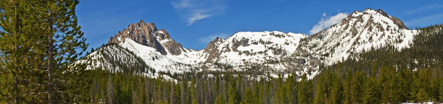
Named for the brilliant sockeye salmon that return each year after a 900 mile journey from the sea, Redfish Lake is the largest lake in the Sawtooth National Recreation Area. These fish were in such numbers that it's said the lake would shimmer red. Now endangered, most of the sockeye returning to the lake are bred in the nearby Sawtooth Fish Hatchery.The 217,000 acre Sawtooth Wilderness provides the backdrop for this dramatic setting, including the peaks which frame the lake at its south end: Mount Heyburn at 10,229' (3,118 m) and Grand Mogul at 9,733' (2967 m). Known for clear air, clean water and classic alpine beauty, this wilderness is home to a diversity of wildlife including bald eagles, osprey, elk and deer, gray wolf, mountain goat, and the elusive wolverine.
Prehistoric hunters inhabited the Redfish Lake area as early as 9,500 years ago, using the Redfish rock shelter as cover while they hunted elk, deer, antelope, mammoth, bison and, later, fished for salmon.
Nearby Attractions
The nearby small town of Stanley (5 miles north) provides a rural western atmosphere with limited amenities including lodging, dining, fuel and groceries in winter. To the south, Smiley Creek Lodge (25 miles) offers a restaurant, lodging and snowmobile rentals. Popular activities in the Sawtooth Valley this time of year include hunting, hiking, cross-country skiing, snowmobiling, and hot springing along the Salmon River.STANLEY LAKE CAMPGROUND Campground
List of CampsitesOverview
Stanley Lake Campground is located on the shoreline above beautiful Stanley Lake at the foot of the Sawtooth Mountains.Recreation
Stanley Lake offers excellent boating, water skiing, canoeing, kayaking and fishing for rainbow, cutthroat, brook and bull trout. A boat ramp is located just outside the campground.The Idaho Centennial Trail passes nearby and can be accessed from the Stanley Lake Trailhead across the lake.
Facilities
The campground offers 17 reservable sites, as well as additional first come, first served sites. Vault toilets and drinking water are provided. Roads and spurs within the site are gravel.A scenic overlook is located next to sites 3 and 4, with outstanding views of McGowan Peak and Stanley Lake. Painters and photographers frequent the overlook to capture the views.
Natural Features
The campground is situated on a hillside above the lake in a thick grove of lodgepole pines, at an elevation of 6,500 feet. Most campsites have partial shade and views of the lake and/or the rugged 9860-foot McGowan Peak. Temperatures are cool, with an average summer high of 78 degrees and a low of 40 degrees.Nearby Attractions
Stanley Lake lies within the Sawtooth National Recreation Area, which offers a myriad of excellent hiking and biking opportunities. An estimated 750 miles of trails crisscross the valley and surrounding mountains.Numerous sparkling lakes and streams, including the Salmon River, dot the area, making for great rainbow and native Westslope cutthroat trout fishing. Redfish Lake is nearby, offering additional water recreation opportunities.
Popular area events include an Arts and Crafts Fair in July, and Wagon Days, Salmon Festival, Quilt Fair and Fireman's Ball in September.
ALTURAS LAKE INLET Campground
List of CampsitesOverview
Alturas Lake Inlet Campground is located on the shores of scenic Alturas Lake at the foot of the Sawtooth Mountain Range.Recreation
This site is part of the Sawtooth National Recreation Area, where outdoor activities abound. Alturas Lake offers excellent boating, water skiing, canoeing, kayaking and fishing for bull trout and Kokanee salmon.The 10-mile round trip Alpine Meadows Trail begins nearby, with spectacular canyon, meadow and alpine lake views. The trail is also a popular area for bird watching.
Facilities
This campground contains several family campsites, some of which have lake or creek views. Vault toilets and drinking water are provided. Roads and parking spurs are gravel.A day-use site is adjacent to the campground with a designated swim beach. Smokey Bear Boat Ramp is less than 1/4-mile away.
Natural Features
Alturas Creek runs through the campground, where summer wildflowers are plentiful and a mixed-growth conifer forest provides partial shade. Temperatures are cool, with an average summer high of 78 degrees and a low of 40 degrees.Nearby Attractions
The Sawtooth National Recreation Area offers a myriad of excellent hiking and biking opportunities, and an estimated 750 miles of trails crisscross the valley and surrounding mountains.Perkins Lake is less than 2 miles away, with excellent fishing and canoeing. Pettit and Yellowbelly Lakes are nearby, with more fishing, canoeing and hiking. The Salmon River offers fishing for rainbow trout, Westslope cutthroat trout and occasional hybrid cutbows and bull trout.
Popular area events include an Arts and Crafts Fair in July, and Wagon Days, Salmon Festival, Quilt Fair and Fireman's Ball in September.
SUNNY GULCH CAMPGROUND Campground
List of CampsitesOverview
Sunny Gulch Campground sits along the shores of Salmon River in the forests of central Idaho.Recreation
Excellent fishing is right out your back door on the Salmon River, with rainbow trout, Westslope cutthroat trout and occasional hybrid cutbows and bull trout available.Sunny Gulch lies in the heart of the Sawtooth National Recreation Area. A myriad of excellent hiking and biking opportunities are available, and an estimated 750 miles of trails crisscross the valley and surrounding mountains.
Facilities
Sunny Gulch offers several campsites, a handful of which are close to a large picnic shelter. These sites and the shelter are perfect for a family reunion, wedding or other special event. The shelter contains a grill, utility tables, a dutch oven cooking surface and eight picnic tables.Vault toilets and drinking water are provided. Roads and parking spurs are paved.
Natural Features
The campground offers spectacular views of the Sawtooth Mountains. Summer wildflowers are plentiful and lodgepole pines provide partial shade. Temperatures are cool with an average summer high of 78 degrees and a low of 40 degrees.Nearby Attractions
The Alpine Way Trail begins less than a mile from the campground, and the Idaho Centennial Trail passes nearby.Redfish and Stanley Lakes are nearby with great boating, water skiing, canoeing, kayaking and fishing. Numerous additional sparkling lakes and streams dot the area.
Popular area events include an Arts and Crafts Fair in July, and Wagon Days, Salmon Festival, Quilt Fair and Fireman's Ball in September.
LOWER PENSTEMON Campground
List of CampsitesOverview
Lower Penstemon Campground is located along the scenic Rock Creek Road, in southern Idaho, at an elevation of 6,600 feet. Visitors come to the area to enjoy its abundant trails and natural beauty.Recreation
Hiking, mountain biking, horseback riding and off-road vehicle trails crisscross the surrounding area. Third Fork, Pike Mountain, Rim View and Porcupine Spring trails all begin nearby. Rock Creek runs along the campground, offering good trout fishing.Facilities
The campground contains single-family campsites with picnic tables and campfire rings. Vault toilets and drinking water are provided. Roads and parking spurs within the campground are gravel. Because the campground is situated along the main road, some noise from passing cars is to be expected.Natural Features
The campground is situated in a mixed conifer and aspen forest, just off Rock Creek Road. Most sites have partial shade. Summer wildflowers dot the landscape and wildlife can be seen frequently in the surrounding area.PORCUPINE SPRINGS Campground
List of CampsitesOverview
Porcupine Springs Campground is located along the scenic Rock Creek Road, in southern Idaho. It sits at an elevation of 6,950 feet. Visitors enjoy the area for its abundance of trails and scenic beauty.Recreation
Numerous hiking, biking, horseback riding and off-road vehicle trails begin within or near the campground, including Porcupine Springs, Ross Falls, Rim View, Pike Mountain and Third Fork trails. Fishing is popular on Rock Creek.Facilities
This large campground contains three group sites that each accommodate up to 50 and 100 people. The recently updated sites are accessible and equipped with picnic tables, grills, serving and utility tables and campfire circles. The group site on Loop C has large corrals for horses.Several single-family campsites are available as well. Each is equipped with a picnic table, campfire ring, grill and a utility table. Additional sites not listed for reservation are available on a first-come, first-served basis. Accessible vault toilets and drinking water are provided. A campground host is located on-site. Roads and parking spurs within the campground are gravel.
Natural Features
The campground is situated in a scenic forest of pine and aspen trees. Summer wildflowers are vivid and abundant, and wildlife frequents the area.THOMPSON FLAT Campground
List of CampsitesOverview
Thompson Flat Campground is located high in the Albion Mountain Range of southern Idaho, near the towns of Declo and Albion. Visitors enjoy the area for its abundant trails, alpine lakes and scenic beauty.Recreation
The Twin Lakes Campground area is located just outside the campground and across the road. It offers picnic areas, horse corrals and access to a variety of trails.Lake Cleveland is a two-mile drive from the campground, offering fishing, canoeing and trail opportunities. Several additional hiking, mountain biking, horse and off-road vehicle trails are on the mountain.
Facilities
The campground contains three group sites, which can accommodate from 40 to 64 people, respectively. All sites are equipped with large picnic tables and campfire rings with grills. There are four reservable single units and four double unit campsites as well as 17 additional single-family campsites that are available on a first-come, first-served basis, but the group sites must be reserved.Accessible vault toilets are provided. A campground host is located on-site. Roads and parking spurs within the campground are gravel.
Natural Features
The campground is situated in a beautiful wildflower-filled meadow lined with tall pine and fir trees, on the eastern slope of Mount Harrison. It sits at an elevation of 8,400 feet.Nearby Attractions
A visit up the road to the Mount Harrison Lookout offers interesting area information and breathtaking panoramic views of the valleys below.Pomerelle Ski Area, just below Thompson Flat, offers lift-served hiking and mountain biking, scenic chairlift rides and a few dining options, generally on weekends.
NORTH FORK (ID) Campground
List of CampsitesOverview
North Fork Campground is situated on the banks of the beautiful Big Wood River at an elevation of 6,300 feet. Visitors enjoy fishing and tubing on the river and exploring the Harriman Trail.Recreation
This site is part of the Sawtooth National Recreation Area, where outdoor activities abound. Fly-fishing for rainbow, brown and brook trout is popular on the Big Wood River, as is float tubing.The 20-mile Harriman Trail leads past the campground, offering excellent hiking and biking. Numerous additional trails spur off the Harriman Trail leading to deep canyons, sparkling lakes, swimming holes and more excellent high country fishing.
Facilities
The campground contains several family sites, some of which are offered on a first-come, first-served basis. Vault toilets and drinking water are provided. Firewood is available for purchase from the host. Roads and parking spurs are gravel.Natural Features
A scenic aspen forest covers North Fork, offering plentiful shade. Pines dot the landscape and colorful summer wildflowers are abundant. Willows and grasses line the riverbank. Temperatures are cool with an average summer high of 78 degrees and a low of 40 degrees.Nearby Attractions
The Sawtooth National Recreation Area Visitor Center is 1/2-mile from the campground, with a small museum, bookstore and area information. An RV dump station and drinking water are located here as well.Easley Hot Springs is 6 miles north, offering a swimming pool, hot tubs, showers and a small store.
Popular area events include Wagon Days in Ketchum in September.
LAKE CLEVELAND - EAST SIDE Campground
List of CampsitesOverview
Lake Cleveland Campground is a very popular summer recreational facility. Located next to its namesake, the campground is divided into the East Side and West Side loops. Very popular with residents of local communities, the campground is often full every weekend from early July to Labor Day.Recreation
Fishing, kayaking, hiking and swimming are all popular activities within the Lake Cleveland area during the summer months. Non-motorized boating and floating is allowed on Lake Cleveland. Motorized recreation is limited to system roads and trails; no cross-country motorized travel is allowed.Facilities
Seventeen camping sites are located in the East campground loop, seven of which are reservable, the remaining ten are first-come, first-served. The East side of the lake is best suited for large RVs and trailers. Nine campsites are available on the West side of the lake on a first-come, first-served basis. Trailers are not advised on the West side of the lake because the turn-around is very tight (limited space due to steep terrain).Natural Features
At an elevation of 8,300 feet, the campground facility is located in an alpine lake basin below Mt. Harrison which has an elevation of 9,240 feet. Late season snowdrifts on the county road and in the campground often block access until early to mid-July. The campground is near the timberline and alpine wildflower meadows. Expansive views north across the Snake River Plain and south into Utah and Nevada can be found near the campground.Nearby Attractions
Two miles from Lake Cleveland, Mt. Harrison has a fully functional fire lookout tower. Nearby Pomerelle ski area offers lift-served access to mountain bike and hiking trails. Two miles away, Twin Lakes Campground offers equestrian facilities and access to the Skyline Trail which is open for hiking, horseback riding, mountain biking and dirt bikes.Redfish Lake Visitor Center Facility
Visitor Center and Interpretive Program
Pettit Lake Day Use Area Facility
Pettit Lake Day Use Area is a first-come, first-serve area and there is no fee. It offers access to the boat ramp and Pettit Lake for swimming, boating, canoeing, fishing and kayaking. Spend the day relaxing and taking pictures, exploring the wildflowers and beautiful Sawtooth wilderness, or celebrating special occasions. There is water, picnic tables and vaulted toilets. No personal watercraft are allowed on Pettit Lake.
Yellowbelly Lake Facility
This is an alpine lake.
Perkins Lake Facility
Access to Perkins Lake is from Alturas Lake Road. Motorized boats and personal water craft are not allowed on Perkins Lake.
Williams Creek Trailhead Facility
Williams Creek Trailhead
Fisher Creek Trailhead Facility
Fisher Creek Trailhead
Fourth of July Creek Trailhead Facility
Fourth of July Creek Trailhead
Champion Creek Trailhead Facility
Champion Creek Trailhead
Hell Roaring Creek Trailhead Facility
Hell Roaring Creek Trailhead
Tin Cup Hiker Trailhead Facility
This trail leads to the popular Alice Toxaway Loop. You will encounter Alice lake, Toxaway lake, Twin lakes, and Farley lake along this loop. You will get to experience several mountain peaks including McDonald's peak, El Capitan, Parks peak, Snowside peak and Imogene peak. There are several day hikes that you can take that lead off the Alice Toxaway Loop to experieice other alpine lakes and peaks in the area. There are no campfires permitted on the Alice Toxaway Loop but you are encouraged to bring portable cook stoves. Motorized vehicles and bicycles are not allowed in any of the designated wilderness areas.
Cabin Creek Trailhead Facility
Hike from TH to Cabin Creek lakes.
Alturas Lake Creek Trailhead Facility
Alturas Lake Creek Trailhead
Champion Creek Cutoff Trailhead Facility
Champion Creek Cutoff Trailhead
Three Cabins Creek Trailhead Facility
Three Cabins Creek Trailhead
Bowery Trailhead Facility
Bowery Trailhead
Grand Prize Trailhead Facility
Grand Prize Trailhead
Twin Creek Trailhead Facility
Twin Creek Trailhead
Titus Creek Trailhead Facility
Titus Creek Trailhead
Gladiator Trailhead Facility
This is the beginning of a great trail that allows you to explore two old cabins.
Prairie Creek Trailhead Facility
Prairie Creek Trailhead
Sawtooth Wilderness Facility
The spectacular beauty and solitude of the 217,000 acre Sawtooth Wilderness is experienced by people from all parts of the country. It is considered the "crown jewel" of the Gem State. First protected in 1937 as a "Primitive Area," the rugged Sawtooth Wilderness was officially created by Congress in 1972. The Sawtooth Wilderness is exceptional in scenic beauty and is characterized by high granite peaks and narrow glacial valleys. The Wilderness is comprised of hundeds of jagged peaks, 50 over 10,000 feet in height, with nearly 400 high alpine lakes dotting the predominantly rocky terrain. Also hidden within its boundaries are deep, secluded valleys covered with enormous stands of trees. These mountains hold the headwaters of the North Fork and Middle Fork of the Boise River, the South Fork of the Payette River and contributes significantly to the headwaters of the Salmon River. Nearly 350 miles of trails provide a wide range of routes and many of the high lake basins do not have constructed trails to reach them. The hiking season is short. Alpine wildflowers bring the high meadows alive with color in the months of July and August. An abundant population of wildlife thrives upon the lush, grassy meadows and many species of fish make their home in the thousands of streams that feed the headwaters of four major rivers. The Wilderness offers opportunities for recreational, scenic, scientific, educational, conservation and historic purposes.
Fairfield Ranger District Facility
The Fairfield Ranger District, established in 1906 with consolidation of the Shake Creek and Fairfield Ranger Districts in 1972, encompasses 420,720 acres of Forest system administered lands and contains over 680 miles of streams and more than 20 high mountain lakes. There are many mountains on the District over 9,000 ft. in elevation, with four peaks--Baker Peak, Big Peak, Two Point Mountain, and Smoky Dome that are over 10,000 ft. high in elevation. The South Fork of the Boise River, Little Smoky Creek and Big Smoky Creek are the major river drainages. Fairfield offers seemingly endless opportunities for the backpacker, hiker, horseback rider, mountain biker and off-road vehicle user. There are 440 miles of inventoried trails on the District, many of which top out in mountain lakes or circque basins. Snowmobiling, downhill skiing, and snowboarding are some of the more popular winter activities on the District. There are about 50 miles of groomed snowmobile trails available north of Fairfield. Nordic skiing opportunities may be found in the backcountry through helicopter and cat ski guided trips into more remote areas. Visitors will find numerous hot springs on the District, accessable in the summer, including Worswick, Skillern, Willow Creek, Pries, and Baumgartner. Fairfield boasts (12) campgrounds. Baumgartner Campground is fully accessible to visitors using wheelchairs and includes paved camping sites. The campground also boasts a hot pool for soaking, a children's play area and a 1/4 mile interpretive trail.
Bowns Campground Campground
List of CampsitesBowns Campground, located 25 miles east of Featherville and 18 miles north of Fairfield, is a developed campground composed of 10 units along Big Smoky Creek. Two of the camp sites are double family units. Camping, fishing, hiking, and picnicking are popular activities. Campground amenities include picnic tables, fire rings, drinking water (seasonally) and restrooms. Miller Creek Trail (#087) starts just south of the campground and is open to motorcycles.
Fairfield Ranger Station Facility
The Fairfield Ranger Station is located at 102 1st Street East in Fairfield, ID. The Station is the Administration Site for the Fairfield Ranger District, including the Soldier Mountain Ski Area and 12 developed campgrounds.
Hunter Creek Transfer Camp Facility
Located 20 miles northwest of Fairfield through Cow Creek Reservoir on Road No. 055, the campground offers 3 single camping units, and 1 multi-family unit. Corrals, mangers and barrier free stock loading ramps are available along with restrooms. No water is available. The trailhead for the North Fork Lime Creek Trail No. 044 is located at the north end of the campground and connects with the Virginia Gulch Trail No. 037.
Bear Creek Transfer Camp Facility
Bear Creek Transfer Camp is located 32 miles north of Fairfield. Travel over Fleck Summit on Road No. 012. Once at the summer home area, turn onto Road No. 079 and continue north past the Methodist Church Camp then turn left on to Road No. 889 and look for the entrance sign. The transfer camp offers 6 campsites with picnic tables and fire rings along with corrals and mangers with barrier-free stock loading ramps and stock water. There is one restroom available.
Canyon Transfer Camp Facility
Canyon Campground is a non-reservation campground composed of 7 single units and 3 group sites on Big Smoky Creek. Campground amenities include picnic tables, fire rings, drinking water, restrooms, horse corrals and a stock loading station. The Big Smoky Trail #072 begins at the north end of the campground and leads to Skillern Hot Springs. Big Smoky trail is open to non-motorized travel and motorcycles. Numerous trails split off of the main Big Smoky Trail, some of them are only open to non-motorized travel. Please be sure to pick up a Motor Vehicle Use Map from the local Ranger Station.
Big Hole Facility
Big Hole is currently between two large road washouts and is inaccessible by vehicle-you may access it via non-motorized travel and motorcycle only. The restroom is not being maintained.
Big Hole is a day use site on the South Fork of the Boise River located 6 miles west (down river) from the Big Smokey Gaurd Station area on Road No.227. Popular for it's swimming hole, the area provides access to fishing, parking and a restroom.
Minidoka Ranger District Facility
The Minidoka Ranger District encompasses 604,168 acres of National Forest system land. Wildflowers, wildlife and recreation opportunities abound on its five unique divisions--Cassia, Albion, Sublett, Raft River and Black Pine. The Cassia Division, 40 miles south of Twin Falls, contains over 450 miles of streams, including the main Rock Creek drainage, popular with many anglers. The Albion Division, located 20 miles southeast of Burley, is home to Cache Peak (10,339 ft.), which is the tallest peak in the Albion Mountain Range. The Sublett Division, located east of Idaho Interstate 84, offers fishing and camping near Sublett Reservoir. The Raft River Division, located in northern Utah, northwest of Salt Lake City, offers an expansive view from its 9,600 ft. mountain peaks of the Great Salt Lake, Snake River Plain, the Sawtooth Mountain Range and into the state of Nevada. The Black Pine Division located east of the Albion Division and west of Idaho Interstate 84 near the Idaho/Utah border, is popular for gathering pine nuts, the gourmet snack of the pinyon pine tree which grows abundantly in the area. Recreation is undoubtedly the most popular pursuit on the Minidoka Ranger District. Summer activities include camping, picnicing, hiking, rock climbing, horseback riding, mountain biking, and all-terrain vehicle trail machine riding. Winter brings opportunities for alpine and nordic skiing, and snowmachine travel. Hunting and fishing are popular on the District. Six alpine lakes, three reservoirs, and numerous streams are included within the District boundaries. Forested areas and rangeland provide habitat for wildlife species including mule deer, moose, elk, wild turkey, bobcat, cougar, many small mammals, and a wide variety of birds. The District manages (#?) camping units in 25 developed campgrounds. The district maintains over 341 miles of trails to meet needs for motorized and non-motorized use.
Cassia Division Facility
The Cassia Division is a short 40 minute drive south of Twin Falls and is known to local residents as the "South Hills." The division's proximity to Twin Falls makes this area appealing to residents of the Magic Valley. The Cassia Mountain Range rises to a top elevation of 8,400 ft. and these scenic mountains are covered by a variety of rangeland and forest vegetative types. Mixed stands of subalpine fir, lodgepole pine and aspen are interspersed among rolling grasslands. Visitors come to this area to relax, picnic, hike, horseback ride or ride mountain bikes on the many miles of trails that traverse these gentle mountains. The division has 12 developed campgrounds with a total of (#?) camping units, many of which are free of charge. There is 1 picnic area with 10 sites, including the Harrington Fork Picnic Area which has paved walkways accessible for wheelchairs and walking aids. The Cassia Division is popular with deer hunters and Big Cottonwood Creek and Goose Creek are streams with good trout fishing. Winter sports are popular activities. Magic Mountain Ski Resort offers hours of enjoyable skiing with challenging terrain and good snow. The resort has two double chair lifts, one poma(?), one rope tow and 20 runs. The resort is only lightly wooded and is a popular destination for cross-country skiers. Off the head of Rock Creek are 4 cross-country ski trails ranging in length from 1.2 to 8.1 miles. Three of these trails are groomed regularly. There are 30 miles of groomed snowmobile trails and another (#?) miles of ungrommed, marked routes.
Diamondfield Jack Campground Campground
List of CampsitesDiamondfield Jack Campground and Picnic Area is located at the end of a paved road in Rock Creek. The campground is suitable for motor homes, trailers, and tent camping. This area is accessible year around. Campground amenities include drinking water, wheelchair accessible toilets, picnic tables, warming shelter, parking area, and fire rings. It is a winter play area from December through March. Pike Mountain and Eagle Trails (#239 and #243) are easy multi-use trails nearby.
Pike Mountain Scenic Overlook Facility
Pike Mountain Scenic Overlook
Harrington Fork Picnic Area Facility
Harrington Fork Picnic Area is accessible for a season that varies usually between April and October. The picnic area is fully accessible. Amenities include hand pumps and handicapped accessible toilets. No overnight camping is allowed. The Harrington Fork Trail (#006) is immediately accessible to the picnic area and it is a moderate terrain ten mile multi-use trail. Anglers can take advantage of the Harrington Fork Rock Creek that runs near the picnic area.
Pettit Campground Campground
List of CampsitesPettit Campground and Picnic Area is composed of 8 individual units.The area is suitable for motor homes, trailers and tent camping. This is a fee campground. Fee envelopes and a collection box are provided near the campground entrance. This area is accessible for a season that varies usually between June and September. Campground amenities include toilets. A campground host manages the campground and visits the area weekly. No water is available at this site.
Bostetter Campground Campground
List of CampsitesBostetter Campground is composed of 10 individual units and 1 group unit. It is located in a stand of Lodgepole pine and stretches along Cottonwood Creek with one site tucked up above in some Aspen trees. The campground is pack it in and pack it out. The area is suitable for trailer and tent camping. Anglers can take advantage of a nearby stream. Campground amenities toilets.
Big Bluff Dispersed Camping Area Facility
Designated dispersed camping area with 3 sites. It is located between Steer Basin and Harrington Fork.
Albion Division Facility
The Albion Division, located approximately 20 miles southeast of Burley, Idaho, encompasses 95,000 acres of National Forest system land. Beautiful wildflowers can be seen and wildlife is abundant. In the summer, camping, hiking and mountain biking are popular. The paved Howell Canyon Road takes visitors up Mt. Harrison where you will find Lake Cleveland, a high alpine lake set in a cirque basin--one of two found south of the Snake River. The lake offers excellent fishing, camping and picnicing opportunities. The lake sits at 8,263 ft. above sea level and is situated on the north side of Mt. Harrison, nine miles up Howell Canyon. Lake Cleveland is a favorite fishing spot for trout fishermen. Non-motorized boats are allowed on the lake. The Lake Cleveland campground facilities can handle 100 people at one time and all facilities are handicapped accessible. A handicapped trail runs completely around the lake. A Sawtooth fire lookout station is also located at the top of Mt. Harrison. This popular visitor attraction offers panoramic views of the surrounding countryside, including the mountain ranges of the Sawtooths and the Tetons, the cinder buttes of the Arco desert, and the Snake River Plain. Howell Canyon is the home of an alpine ski area resort. Both groomed and ungroomed cross-country trails are marked in Howell Canyon, a popular snowmobiling area. A warming hut for winter recreationists is also provided at this location.
Lake Cleveland Campground - West Side Campground
List of CampsitesLake Cleveland Campground is a very popular summer recreational facility. Located next to its namesake, the campground is divided into the East Side and West Side loops. Very popular with residents of local communities, the campground is often full every weekend from early July to Labor Day.
Natural Features:
At an elevation of 8,300 feet, the campground facility is located in an alpine lake basin below Mt. Harrison which has an elevation of 9,240 feet. Late season snowdrifts often block access to the campground until early to mid-July. The campground is near the timberline and alpine wildflower meadows. Expansive views north across the Snake River Plain and south into Utah and Nevada can be found near the campground.
Recreation:
Fishing, hiking and swimming are all popular activities within the Lake Cleveland area during the summer months. Non-motorized boating and floating is allowed on Lake Cleveland. Motorized recreation is limited to system roads and trails; no cross-country motorized travel is allowed.
Facilities:
Seventeen camping sites are located in the East campground loop, seven of which are reservable, the remaining ten are first-come, first-served. The East side of the lake is best suited for large RVs and trailers. Nine campsites are available on the West side of the lake on a first-come, first-served basis. Trailers are not advised on the West side of the lake because the turn-around is very tight (limited space due to steep terrain).
Nearby Attractions:
Two miles from Lake Cleveland, Mt. Harrison has a fully functional fire lookout tower which is open to visitors on most weekends. Nearby Pomerelle ski area offers lift-served access to mountain bike and hiking trails. Two miles away, Twin Lakes Campground offers equestrian facilities and access to the Skyline Trail which is open for hiking, horseback riding, mountain biking and motorcycle riding.
Independence Lakes Campground Campground
List of CampsitesIndependence Lake Campground and Picnic Area is a non-fee campground and picnic area where reservations are not required. There are 5 single sites. This area is accessible for a season that varies usually between July through October. Sites are handicapped accessible. Campground amenities include 9 tables and grills, toilets, and livestock facilities. No drinking water or trash service is available. Nearby Independence Lakes Trail (#35) is 3.1 miles to the Lake. Only non-motorized travel is authorized. The first mile is rocky, however the remainder is a reasonable grade with switchbacks to the first of four lakes in the alpine cirque basin.
Fish Your National Forests: This site can be accessed by Passenger Car; Fish available include: Trout; Types of fishing available include: Wade, Shore, Non-motorized boat, Float tube, Fly, Spin, Bait;
Mt. Harrison Lookout Facility
This lookout post was established in the 1930's before a trailer lookout was added in 1960. The lookout has been updated and now has a hip-roof 2-story R-6 cab, built in 1977. This lookout is open to visitors during on the weekends during the summer.
Sublett Division Facility
The Sublett Division, located east of Idaho interstate 84, is a 90,000 acre expanse of open sagebrush and grass terrain. Pockets of Douglas-fir on northern exposures and open meadows full of wildflowers make it an excellent location to take a scenic drive or a horseback trip. The miles of trails provide year-round opportunities for recreationists. The area is popular with snowmobile enthusiasts in the winter and off-road vehicles riders, hikers, and equestrians in fair weather months. There are approximately 60 miles of groomed snowmobile trails in the winter. In North Heglar Canyon, the Mill Flat Trailhead provides access to numerous trails and old logging roads, providing miles of routes to travel with horses, mountain bikes and all-terrain vehicles. Deer, elk, and moose also can be found in the area.
Raft River Division Facility
The Raft River Division encompasses 95,000 acres of Forest Service administered land and includes the Raft River Mountain Range located in northern Utah, northwest of Salt Lake City. These peaks reach up to an elevation of 10,300 ft. On a clear day, the vista from the top offers a view of the Great Salt Lake, Snake River Plain, Sawtooth Mountain Range and into Nevada. The area is popular among archery and rifle deer hunters and several drainages provide excellent opportunities for fishing in small streams. Clear Creek Campground, which is handicapped accessible, is the Division's only developed campground. The campground serves as trailhead for the Bull Flat (#001) and Lake Creek (#004) Trails. There are also plenty of opportunities for dispersed camping.
Clear Creek Campground Campground
List of CampsitesClear Creek Campground is a non-fee campground and picnic area composed of 12 individual units and reservations are not required. This area is accessible for a season that varies usually between June through October. Campground amenities include toilets and the campground is well suited for tent and RV camping. Sites are handicapped accessible. Bull Flat (#001) and Lake Fork (#004) trails are popular with horseback riders, and hikers.
Black Pine Division Facility
The Black Pine Division, located east of the Albion Mountain Division and west of Idaho Interstate 84 near the Idaho/Utah border, encompasses 90,000 acres of Forest Service administered land. Being more isolated, the area does not receive as many visitors and the pockets of open country offers quite and solitude. Northern slopes are occupied by stands of Douglas fir and sub alpine fir. On southern exposures visitors will find pinyon pine, juniper, sagebrush, and grasses. Hunting for deer and upland game is a popular pastime.
Ketchum Ranger Station Facility
Ranger Station
Galena Lodge Facility
By the 1970s, Galena had become a destination for cross country skiers seeking the beauty of the Boulder Mountains, open meadows, challenging hills and powder slopes. Described by Snow Country as "arguably the best cross country ski trail system in the United States," the North Valley Trails was created in 1992 by the Blaine County Recreation district with help from a dedicated group of volunteers committed to quality, affordable skiing in the northern Wood River Valley. The North Valley Trails system is 100 kilometers of groomed ski trails stretching for over 20 miles between Ketchum and Galena Lodge. Trails are groomed for both skating and classic skiing with 36 kilometers open to doggies with their owners. There are also several trails just for snowshoers.
Bald Mountain Ski Resort Facility
Bald Mountain Ski Resort is operated by Sun Valley Company. Beginning as a dream of Averell Harriman, the resort started ski lift and run construction in 1936. Bald Mountain has 13 chair lifts accessing 66 runs, and 3,400 feet of vertical rise. There are 5 mountain cabins on the ski area, at various locations and elevations on the mountain, with meal service, a place to rest, relax and warm up. For more information call 208-622-2135 at the Hill or 208-622-4111 in Town
Lake Creek Lakes Picnic Area Facility
Picnic area with one table, one fire ring, and an ADA-accessible vault toilet.
Cove Creek Hot Springs Facility
Bathing suits required.
Boulder Foothills Snowmobile Area Facility
Snowmobiling area accessible from the Baker Creek Snowmobile Parking Lot.
East Fork Big Wood River Snowmobile Area Facility
East Fork Big Wood River Snowmobile Area
Sawtooth National Recreation Area Facility
The Sawtooth National Recreation Area (Sawtooth NRA) consists of 756,000 acres of beautiful mountanious scenery. The Sawtooth NRA includes the Sawtooth Wilderness, Cecil D. Andrus-White Clouds Wilderness, and the Hemingway-Boulders Wilderness areas. The Sawtooth NRA has over 700 miles of trails, 40 peaks rising over 10,000 feet and 300-plus high-elevation alpine lakes that add to the spectacular scenery and vistas. Recreational pursuits include outdoor activities like camping, hiking, backpacking, fishing, boating and canoeing, rafting, observing nature, photography and bicycling. For information please contact the Sawtooth NRA Headquarters, open Monday through Friday from 8:30am-5pm at (208)727-5000, the Ketchum Ranger Station, open Monday through Friday 8:30am-5pm at (208)622-0090, the Stanley Ranger Station, open Monday through Friday 8:30am -5pm at (208)774-3000 or the supervisors office in Jerome, open Monday through Friday 8am-4:30pm at (208)423-7500.
Sawtooth NRA Campground Information
Hemingway-Boulders Wilderness Map
Sawtooth NRA Headquarters Facility
The Sawtooth National Recreation Area Headquarters is located just off Hwy 75 in a beautiful building which includes the North Fork Visitor Center. There are many animals on display including a gray wolf, red fox, badger, wolverine, mountain goat, pine martin, great horned owl, and sandhill crane. We offer free brochures and information on hiking, camping, and the history of the Sawtooth National Recreation Area. We have books, maps, and souveniers available for purchase. There are numerous hiking/skiing trails just outside the visitor center and wildlife including black bear, moose, elk, mountain lion and wolves are in the area. For more information please call the Sawtooth NRA Headquarters at (208)727-5000.
Easley Hot Springs Resort Facility
This resort offers swimming in warm non-chlorinated water.
Wood River Amphitheater Interpretive Site Facility
Wood River Amphitheater Interpretive Site
Galena Lodge (Wood River Valley Area) Facility
Galena Lodge is a winter and summer resort located in Idaho's Sawtooth National Recreation Area. Galena can thank a rich history of mining, sheep herding and logging for much of its trail system. Galena has a colorful history dating back to the late 1870's when the first mining claims were made in the area. The name "Galena" refers to basic ore, largely made of lead mixed with silver, found here in the Senate and Gladiator mines. In 1879, Galena was a thriving community of 700 people; by 1890, it was a ghost town. During summer, the lodge offers mountain biking and hiking, dining, a full-service outdoor and rental shop, guided tours and bike lessons. Winter brings to the lodge nordic skiing, snowshoeing, dining, yurt rentals, and more. Galena has become a destination for cross country skiers seeking the beauty of the Boulder mountains, open meadows, challenging hills and powder slopes. Described by Snow Country as "arguably the best cross country ski trail sysem in the United States," the North Valley Trails was created in 1992 by the Blaine County Recreation District with help from a dedicated group of volunteers committed to quality, affordable skiing in the northern Wood River Valley. The North Valley Trails system is 100 kilometers of groomed ski trails stretching for over 20 miles between Ketchum and Galena Lodge. Trails are groomed for both skating and classic skiing with 36 kilometers open to doggies with their owners. There are also several trails just for snowshoers.
Pole Creek Guard Station Facility
Guard Station
Prairie Creek Facility
Prairie Creek
Boulder Mountain Goat Interpretive Site Facility
This interpretive site has a telescope on the Harriman Trail. This allows visitors to view the goats without disturbing them.
Cougar Dispersed Camping Area Facility
This dispersed campground area is north of Caribou developed campground on the left side of North Fork road. It is situated alongside the North Fork of the Big Wood River.
Alpine Way Trailhead Facility
The Apline Way trailhead begins behind the Stanley Ranger Station and enters the Sawtooth Wilderness to Marshall Lake, and continues along the Alpine Way trail past Goat lake and connects with Iron Creek to Alpine lake and Sawtooth lake.
Boundary Creek Trailhead Facility
Boundary Creek Trailhead
Murdock Trailhead Facility
Murdock Trailhead
Oregon Gulch Trailhead Facility
Oregon Gulch Trailhead
Lake Creek Trailhead Facility
Lake Creek Trailhead
Adam Gulch Trailhead Facility
Trailhead
Stanley Lake Overlook Facility
Stanley Lake Overlook
Stanley RV Concession Site Facility
Stanley RV Concession Site
Sunbeam Resort Facility
Sunbeam Resort
Buckhorn Facility
This is a great recreation area.
Elk Meadow Trailhead Facility
Elk Meadow Trailhead
Elk Mountain Trailhead Facility
Elk Mountain Trailhead
Stanley Lake Trailhead Facility
Stanley Lake Trailhead
Iron Creek Trailhead Facility
Iron Creek Trailhead
Grandjean Trailhead Facility
This trailhead leads to a hike along the South Fork Payette River.
Alpine Way Trailhead Facility
Trailhead
Sunbeam CCC Hotsprings Interpretive Site (Bathhous Facility
Civilian Conservation Corps (CCC) built this bathhouse in 1937. At one time it contained pools and tubs.
Sunbeam Dam Facility
Sunbeam Dam was built on the Salmon River in 1910. It provided power for one year before it was shut down. The dam was partially blown up in 1934.
Sunbeam Resort Facility
This resort is on the Yankee Fork and Salmon Rivers. It has an on-site restaurant with indoor/outdoor seating. You can also pick up great souvenirs.
Centauras Mine Site Interpretive Site Facility
Interpretive site
Indian Riffles Interpretive Site Facility
Interpretive site.
Stovepipe Springs Dispersed Camping Area Facility
Stovepipe Springs Dispersed Camping Area
Torrey's Hole Facility
This is a boat ram that access the Upper Salmon River
Casino Creek Trailhead Facility
Casino Creek Trailhead
Rough Creek Trailhead Facility
Rough Creek Trailhead
Boulder Creek Trailhead Facility
Boulder Creek Trailhead
Redfish Lake Lodge Facility
The privately owned, Redfish Lake Lodge is located at the north end of the lake and includes a restaurant, boat rental, and shuttle service to the wilderness trailhead at the southwest end of the lake.
Little Redfish Lake Facility
Motorized boats are not allowed on Little Redfish lake.
Redfish Corrals Facility
Guided horseback rides through the Sawtooth Wilderness.
Sandy Beach Boat Ramp - Day Use Location Facility
Sandy Beach boat ramp at Redfish Lake
Orval Hansen Point Beach Facility
Swimming beach near Point Campground on Redfish Lake.
Redfish RV Concession Facility
Redfish RV Concession
Mountain View Campground Campground
List of CampsitesThis campground is located on the east side of Little Redfish Lake. There are six campsites which are all first-come, first-serve. Enjoy fishing, canoeing, kayaking, swimming and camping alongside Little Redfish Lake. Several trailheads are in the surrounding area including Alpine Way and Redfish which lead into the Sawtooth Wilderness, and Boundary Creek trail which leads into the White Clouds Wilderness. Photography of the beautiful Sawtooth and White Clouds Wilderness areas and surrounding lakes and mountains is very popular here. Redfish Lake Visitor Center offers informational and interpretive programs. Motorized watercraft are not allowed on Little Redfish Lake.
FS Flats Facility
Recration area with picnic tables, fire rings, and two vault toilets.. There 2 large group sites and 19 individual sites. There are also two ATV trails that leave from near the campsites and link up with hundreds of miles of motorized trails in the area.
Lake Cleveland Facility
CLOSED DUE TO HAZARDOUS ROAD CONDITIONS
Lake Cleveland is a popular high mountain lake located in the Albion Mountains just below Mt. Harrison at the head of Howell Canyon. Fishing this non-motorized lake is a popular recreational activity. The lake is stocked by the Idaho Fish and Game Department. The west and east sides of the lake both have developed campsites; the fee is $10.00 per night. Search for Lake Cleveland under camping on the Minidoka Ranger District of the Sawtooth NF website.
Fisher/Williams Creek Loop Facility
The Fisher Creek Loop is the signature mountain bike trip in the scenic Sawtooth NRA. The complete loop is a combination of Forest Service road challenging single track and a brief strip of pavement on Hwy 75. Bike through lodgepole pine forests (burned in the valley fire of 2005), aspen groves, open meadows, and fields of wild flowers along some of the best trails in the west. Total loop distance 17.5 miles and elevation gain of 1500 ft.
Hemingway-Boulders Wilderness Facility
This special area is located in the Sawtooth National Recreation Area and was designated a wilderness area, along with the White Clouds Wilderness, in 2015. The Hemingway-Boulder Wilderness is unique in its geological formations and location near the Jim McClure-Jerry Peak Wilderness and the White Clouds Wilderness. This Wilderness area is includes varous forks of the Salmon River and Big Wood River and many creeks including King Creek, Ibex Creek, and Lost Mine Canyon Creek. There are several very high elevation peaks and many deep canyons which make for wonderful habitat for numerous species of wildlife to thrive including mountain lions, wolves, mountain goats, elk, and moose. Some of the tallest peaks in the area include Galena Peak, Easley Peak, Silver Peak, Ryan Peak, Kent Peak and Glassford Peak, several of which are over 11,000 feet in elevation. There is tremendous fishing available in the rivers and creeks in the Hemingway-Boulder Wilderness as well as incredible hikes with terrific opportunities to view nature and the abundant wildlife. Photography is very popular in this wilderness area because of its unique blend of natural structures and incredible landscapes. This wilderness offers opportunities for recreational, scenic, scientific, educational, conservation and historic purposes. Motorized vehicles and bicycles are not permitted in any designated wilderness areas.
Cecil D. Andrus-White Clouds Wilderness Facility
The Cecil D. Andrus-White Clouds Wilderness is part of the Sawtooth National Recreation Area and was designated a wilderness area in 2015. It is situated along the Salmon River adjacent to the Salmon River Mountains in the Salmon-Challis National Forest and to the north of the Hemingway-Boulders Wilderness and the Jim McClure-Jerry Peak Wilderness. The Cecil D. Andrus-White Clouds Wilderness is a special area due to its combination of sub-alpine lakes, abundant creeks, hiking trails and the limestone and metamorphic silicates which give the mountain peaks its striking white appearance. There are numerous spectacular mountain peaks includinf Propsect Point, Robinson Bar Peak, Lookout Mountain, Watson Peak, O'Calkens Peak, David O. Lee Peak, Merriam Peak, Castle Peak and Blackman Peak, many of which are over 10,000 feet in elevation. There is incredible fishing in the dozens of clear sub-alpine lakes in the area including the Big Boulder Lakes and Boulder Chain Lakes, The Cecil D. Andrus-White Clouds Wilderness is host to many beautiful creeks including Blind Creek, Elk Creek, Warm Springs Creek, Beaver Creek, Germania Creek, Little Boulder Creek, Chamerlain Creek, Bear Lake Creek and many more. The hiking season is short with the alpine wildflowers bringing the area alive with color in the months of July and August. There are fabulous opportunities for viewing the scenery, plants and wildlife in this beautiful and very special wilderness. The Cecil D. Andrus-White Clouds Wilderness offers opportunities for recreational, scenic, scientific, educational, conservation and historic purposes. Motorized vehicles and bicycles are not allowed in any designated wilderness areas.
Smiley Creek Concession Site Facility
Smiley Creek Concession Site
North Fork Wood River Trailhead Facility
North Fork Wood River Trailhead
Snyder Springs Picnic Area Facility
This picnic area is located to the east of Stanley along the beautiful Salmon river. It is an excellent for relaxing along the Salmon river and picnicking. Hiking, fishing, and viewing the wildlife and scenery is excellent here on the edge of the White Clouds Wilderness area. This site does not have drininkg water. This area is first-come, first-serve.
