
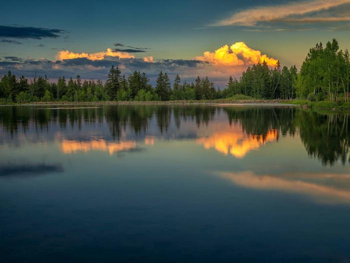
Dixie National Forest
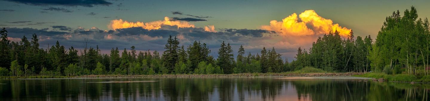
The Dixie National Forest offers a variety of recreation opportunities all year round. With almost 2 million acres to explore, there are endless opportunities for your enjoyment, and relaxation. You can experience the solitude of hiking in the Wilderness, enjoy camping in developed campgrounds, or in the backcountry. The forest is also a prime location for fishing, hunting, horseback riding, mountain biking, OHV opportunities, and winter activities such as cross-country and downhill skiing. There are hundreds of miles of forest roads that offer sightseeing opportunities and access to beautiful country.
Plan Your Visit To The Forest
RecAreaDirections
Open with Google Map
Misc
| Stay Limit | |
| Reservable | false |
| Keywords | |
| Map Link | |
| Contact Phone | |
| Contact Email |
Permits info
Facilities
KINGS CREEK Campground
List of CampsitesOverview
Kings Creek Campground is located on the west side of Tropic Reservoir, high on the Colorado Plateau at an elevation of 8,000 feet. Visitors enjoy boating, fishing and exploring local ATV trails.Recreation
Kings Creek is a favorite of ATV enthusiasts because of its easy access to a large network of trails. The Fremont ATV trail passes within 1/4 mile of the campground and the Great Western Trail is nearby.Hiking and mountain biking trails are plentiful as well, with access from various points within the campground.
Tropic Reservoir offers boating, canoeing and fishing for brook, rainbow, brown and cutthroat trout. A boat ramp is within 1/2-mile of the the campground. The East Fork Sevier River is nearby with good fishing opportunities.
Facilities
The campground offers two group sites, which can be reserved separately or together. The group area is isolated from the main campground and provides privacy for gatherings and events. All individual sites are managed on a first come, first served basis. A large covered pavilion with picnic tables is also included with the group site to provide shade and cover from the weather. Flush toilets and drinking water are provided. The campground and reservoir are reached via a well-maintained gravel road with good access for cars and RVs alike.Natural Features
Tropic Reservoir is situated at the foot of beautifully forested mountains in Southern Utah. The campground is nestled among towering pines on a hillside above the reservoir.Nearby Attractions
Bryce Canyon National Park is 12 miles from the campground, with breathtaking scenery and excellent hiking opportunities.Kodachrome Basin State Park is an hour away, with towering rock spires, a natural arch and great hiking trails.
PINE LAKE CAMPGROUND Campground
List of CampsitesOverview
Pine Lake Campground is located next to its scenic namesake lake high on the Colorado Plateau at an elevation of 8,100 feet. Visitors enjoy canoeing, fishing and exploring local hiking and off-road vehicle trails.Recreation
A short trail leads from the campground to Pine Lake, which offers excellent canoeing and kayaking, as well as fishing for rainbow, cutthroat and brook trout. Hiking and off-road vehicle trails are plentiful within the area, however off-road vehicles are not allowed in the campground.The Pine Lake OHV Trailhead is located adjacent to the campground. A loading ramp is provided.
Facilities
The campground offers four group sites and 17 family sites. Accessible vault toilets and drinking water are provided. A well-maintained gravel road leads to the campground, providing good access for cars and RVs alike.Natural Features
Pine Lake is situated at the foot of beautifully forested peaks banded with red and white layers of sandstone. The campground is nestled among a forest of spruce and towering ponderosa pines, and is adjacent to Pine Lake.Nearby Attractions
Bryce Canyon National Park is approximately 30 minutes from the campground, offering breathtaking scenery and excellent hiking opportunities. Kodachrome Basin State Park is an hour away, with towering rock spires, a natural arch and great hiking trails.POSEY LAKE CAMPGROUND Campground
List of CampsitesOverview
Posey Lake Campground is located next to its beautiful namesake lake high on the Colorado Plateau at an elevation of 8,800 feet. Visitors enjoy canoeing, fishing and exploring local trails.Recreation
Posey Lake offers rainbow and brook trout fishing, canoeing, kayaking and non-motorized boating. Two hiking trails begin at the campground. The Posey Overlook Trail is a mile long and leads to a beautiful overlook. The Posey Spur Trail connects the campground to the Great Western Trail, which provides excellent hiking and mountain biking.Facilities
The campground contains 21 single-family sites and one group site for up to 35 people. Drinking water is provided from Memorial Day through Labor Day.Facilities at this campground include accessible vault toilets, a fish cleaning station and two fishing docks. Roads and parking spurs are gravel.
Natural Features
The campground is situated on a hillside above Posey Lake. A scenic forest of towering ponderosa pines covers the area. Clusters of aspens dot the landscape and summer wildflowers are abundant.Nearby Attractions
Posey Lake offers a cool escape from the surrounding desert landscape and is often used as a base to explore the surrounding region. The Escalante area of southern Utah offers breathtaking scenery nearly everywhere you look.Sightseeing along Forest Road 153 (Hell's Backbone) and Utah Highway 12, a National All American Highway, is very popular. The Grand Staircase-Escalante National Monument, Anasazi State Park, and the Escalante Petrified Forest State Park are all located in the area.
CEDAR CANYON Campground
List of CampsitesOverview
Cedar Canyon Campground is located conveniently close to Cedar City, Utah, only 11 miles east. Visitors can enjoy hiking, biking and day-tripping to nearby Cedar Breaks National Monument.Recreation
Cedar Canyon is just 8 miles from Cedar Breaks National Monument, with hiking trails, guided tours and breathtaking scenery. Just outside Cedar Breaks is the Ashdown Gorge Wilderness Area, where hikers will find 10 miles of trails and the Twisted Forest, a stand of ancient bristlecone pine. The 34-mile Virgin River Rim Trail is located near the campground with a short drive for access and is open to hiking, mountain biking and horseback riding.Facilities
The campground offers a small group site and several family sites. Vault toilets and drinking water are provided but no showers are available. Roads and spurs are paved.
OHV/ATV's including street legal are not allowed in the campground.
Natural Features
Crow Creek flows alongside the campground, which is settled on the western edge of the Colorado Plateau at an elevation of 8,100 feet. A forest of fir and aspen covers the site, providing shade in most campsites.Nearby Attractions
Cedar Canyon is close to many areas with excellent recreational opportunities. Navajo Lake and Duck Lake are both within 20 minutes, offering boating, canoeing and fishing. The Markagunt ATV Trail System is easily accessed 5 miles to the east. OHV's are not allowed in the campground.DEER HAVEN Campground
List of CampsitesOverview
Deer Haven Campground is situated high on the western edge of the Colorado Plateau, close to Cedar City, Utah. Visitors enjoy hiking, biking and day-tripping to nearby Cedar Breaks National Monument.Recreation
The 34-mile Virgin River Rim Trail passes near the campground and is open to hiking, mountain biking and horseback riding.Deer Haven is just 11 miles from Cedar Breaks National Monument, with hiking trails, guided tours and breathtaking scenery.
Just outside Cedar Breaks is the Ashdown Gorge Wilderness Area, where hikers will find 10 miles of trails and the Twisted Forest, a stand of ancient bristlecone pine.
Facilities
This campground offers one large group area for family reunions, youth and church groups and other large organizations of up to 200 people. Ten single sites are available on a first-come, first-served basis.
Flush and vault toilets are provided. Drinking water is piped from a spring, but there is not an abundant supply. Campers area urged to conserve water in all activities.
OHV/ATV's are allowed in the campground for ingress and egress only. No joy riding is allowed in the campground.
Natural Features
Deer Haven is at an elevation of 8,900 feet. This peaceful and scenic campground is surrounded by a forest of aspen and pine trees. Summer wildflowers are abundant throughout the site.Nearby Attractions
Deer Haven is close to many areas with excellent recreational opportunities. Navajo Lake and Duck Lake are both within 30 minutes, offering boating, canoeing and fishing. The Duck Creek/Markagunt ATV Trail System begins nearby.DUCK CREEK Campground
List of CampsitesOverview
Duck Creek Campground is located 25 miles east of Cedar City, Utah. Visitors enjoy fishing in Duck Creek Pond and nearby Navajo Lake, exploring the Markagunt OHV Trail System and the many miles of non-motorized trails. Nearby sites to see are Cascade Falls, Cedar Breaks National Monument, the Ice Cave and Mammoth Caves. It is the perfect place to stay if your plans include visiting Bryce and Zions National Parks.Recreation
Duck Creek Pond offers great fishing for rainbow, brook, brown and cutthroat trout. The Markagunt ATV Trail System can be accessed from within the campground, offering about 300 miles of ATV/OHV routes and trails for riders of all skill levels. The Virgin River Rim Trail is a very popular 32 mile trail that skirts the Virgin River Rim with views of Zions National Park in the distance and the Virgin River Rim. The trail can be accessed in several locations and is within a few minute drive from the the campground. This trail is a non-motorized trail and enjoyed by bicyclist, horses and foot travel. There are many sites in the nearby area such as Cedar Breaks National Monument about a 15 minute drive from the campground and Bryce Canyon National Park approx 50 miles to the east. The Duck Creek Visitor Center is just across the road from the campground and will provide you with all the area information and local attractions such as Cascade Falls, Mammoth and Ice Caves, and excellent fishing at Navajo lake and Panguitch lake.Facilities
Duck Creek offers a variety of campsites for families and groups alike. Flush and vault toilets are provided, as is drinking water from Memorial Day through mid-September. An amphitheater with a covered stage and plentiful bench seating is located in the campground.
There is a OHV parking area that is located on the northeast corner in Loop D between campsites 89 and 90. OHV's including street legal are allowed to ride from your campsite to the trail located in the D loop and back to your campsite only. Joy riding is not allowed in the campground. OHV's are only allowed in the C, D and E Loops. A and B loops are closed to all OHV's including street legal.
The Duck Creek Visitor Center is just across the road from the campground with trail maps and information on the surrounding scenic area.
There is a dumpstation with potable and non-potable water, drinking water spigots are scattered through out the campground. There are no hook-ups to the water so please make sure you fill you trailer before you set up camp at the dumpstation located at the entrance of the campground.
Natural Features
The campground is situated in Aspen and Douglas Fir tree stands with several old growth Ponderosa Pines that are 200 to 500 years old, Which is adjacent to Duck Creek Pond that you can walk to from the campground at an elevation of 8,400 feet. The area is rich in volcanic rock fields that orginated from underground lava tubes.Nearby Attractions
Restaurants, cabin rentals, groceries, fuel are are available located in Duck Creek Village two miles east of the campground. Small aluminum fishing boat rentals, a boat dock, rustic cabin lodging are available at nearby Navajo Lake Lodge which is located on the northwest shore of Navajo Lake a short 6 miles from the campground.
Cedar Breaks National Monument is 10 miles away, with hiking trails, guided tours and breathtaking scenery.
Adjacent to Cedar Breaks National Monument is the Ashdown Gorge Wilderness Area, where hikers will find miles of trails including the Twisted Forest trail that has a stand of ancient bristlecone pine some of which can live up to 5,000 years.
Bryce Canyon National Park is a 35 minute drive to the east, Zions National Park is an hour drive to the south.
The Dixie National Forest offers endless trails both motorized and non-motorized along with high altitude fishing lakes and streams.
Come Stay and Play!
PANGUITCH LAKE Campground
List of CampsitesOverview
Panguitch Lake Campground is located 14 miles southwest of Panguitch, Utah. Some of the state's largest rainbow trout are fished from the lake each year, and aptly so; "Panguitch" comes from the Paiute word meaning "big fish." Visitors also enjoy canoeing and exploring the Panguitch Lake OHV Trail System.Recreation
Panguitch Lake offers great fishing for rainbow, brook, cutthroat and brown trout. Canoeing and kyacking are a popular activity. Two public boat ramps are located on the lake, one on the south shore and the other on the north shore at Wildlife Point. The Markagunt OHV trail system at Panguitch Lake offers 300 miles of routes and trails. Other activities include hiking, biking, horseback riding and hunting.Facilities
The campground is located on both the north side and the south side of the highway. The Panguitch lake north is the larger of the two, with single and double campsites and three group sites. The south side is strictly for tent camping (no reservations).
Amenities include flush toilets and drinking water. There are no hook-ups available so please fill your tanks at the dumpstation just east of the campground prior to setting up. A horshoe pit and a volleyball court are on-site, though campers must provide their own net and ball. An amphitheater near the Panguitch group site is available upon request. The campground road and parking spurs are paved.
Accessible sites area available on the north side of the campground.
No OHV access in or out of the campground including street legal, all OHV's must be trailered.
Natural Features
The lake is situated high on the Colorado Plateau at an elevation of 8,400 feet. A forest of ponderosa pines covers the campground, which lies on a hillside about a quarter-mile above the lake. Deer and elk are often seen in the area.Nearby Attractions
Panguitch Lake has two public boat landings and is less than 5 minutes from the campground. Great fishing from both a boat and the shore or just hanging out on the beach is enjoyed by many! Panguitch Lake Campground is just 14 miles from Cedar Breaks National Monument, with hiking trails, guided tours, wildflower walks, star gazing and awesome views of the Cedar Breaks Amphitheater. Just outside Cedar Breaks is the Ashdown Gorge Wilderness Area, where hikers will find 10 miles of trails and the Twisted Forest, a stand of ancient bristlecone pine. Bryce Canyon National Park is 30 minutes away, with breathtaking scenery and excellent hiking and horse ridng opportunities.TE-AH Campground
List of CampsitesOverview
Te-Ah Campground is located 28 miles east of Cedar City, Utah, in scenic Navajo Lake Basin. Touring bicycle groups commonly use Te-Ah as a stopover on their way through this beautiful corner of Utah. Fishing and canoeing on Navajo Lake are popular activities.Recreation
Navajo Lake offers great canoeing, kayaking and fishing. Hiking and biking are popular activities as well. The Cascade Falls Trailhead is located in the campground. This beautiful trail has abundant wildlife and vegetation.The 34-mile Virgin River Rim Trail passes near the campground and is open to hiking, mountain biking and horseback riding.
Facilities
Te-Ah offers 41 single sites with picnic tables and campfire rings. One group site (#33) is available for up to a group size of 20 people. The site provides tables, bicycle wash and parking racks and a workspace for self-contained kitchens.
Flush and vault toilets are provided and drinking water is piped from a spring. A newly paved road skirts the shoreline of Navajo Lake and leads to Te-ah on the lake's western edge, allowing good access for cars, trailers and bicycles.
OHV/ATV's including street legal are not allowed in the campground. Please trailer them in and out of the campground.
Natural Features
The campground is situated on the edge of a meadow high on the Colorado Plateau at an elevation of 9,200 feet. An aspen forest covers the campground. Navajo Lake can be viewed in the distance from several sites.
Nearby Attractions
Boat rentals, a boat ramp, lodging and supplies are available at nearby Navajo Lake Lodge. Also Duck Creek Pond is eight miles east great for fishing with the kids as well as the Duck Creek Visitor Center.
Cascade Falls, Ice Cave and Mammoth Cave are also near-by favorites!
Cedar Breaks National Monument is a short 20 minute drive, with hiking trails, guided tours and breathtaking scenery.
Just outside Cedar Breaks is the Ashdown Gorge Wilderness Area, where hikers will find 10 miles of trails and the Twisted Forest, a stand of ancient bristlecone pine.
WHITE BRIDGE Campground
List of CampsitesOverview
White Bridge Campground is located just 12 miles southwest of Panguitch, Utah and 55 miles northeast of Cedar City. Visitors enjoy fishing, canoeing on nearby Panguitch Lake and exploring local trails.Recreation
Campers enjoy fishing for rainbow trout in Panguitch Creek. Hiking and biking are popular activities around the campground. The Panguitch Lake ATV Trail System offers 100+ miles of trails and can be accessed nearby.Facilities
White Bridge offers several family campsites. The sites along the creek have natural shade, while the sites across the loop road are more open and equipped with picnic shelters for shade. Flush and vault toilets are provided, as is drinking water and a dump station.
OHV/ATV's including street legal are allowed in the campground for ingress and egress only (to and from your campsite to the road). Joy riding in the campground is not allowed.
Natural Features
The campground is situated high on the Colorado Plateau at an elevation of 7,900 feet. Panguitch Creek runs alongside the campground. Cottonwoods line the creek and aspens, pinion and juniper dot the sagebrush-covered landscape.Nearby Attractions
White Bridge is just 6 miles from Panguitch Lake. Some of the state's largest rainbow trout are fished from the lake each year, and aptly so; "Panguitch" comes from the Paiute word meaning "big fish."Anglers will also find brook, cutthroat and brown trout. Canoeing is a popular activity on this small body of water. Boat ramps are located on the south shore and at Wildlife Point.
Cedar Breaks National Monument, with hiking trails and guided tours, is 16 miles from White Bridge.
Just outside Cedar Breaks is the Ashdown Gorge Wilderness Area, where hikers will find 10 miles of trails and the Twisted Forest, a stand of ancient bristlecone pine.
Bryce Canyon National Park is just over an hour away, with breathtaking scenery and excellent hiking opportunities.
PINE VALLEY RECREATION AREA Campground
List of CampsitesOverview
Pine Valley Recreation Area is located in scenic Pine Valley, Utah at an elevation of 6,900 feet. The valley offers a great escape from the heat of the southern Utah desert. Visitors enjoy fishing at nearby Pine Valley Reservoir and exploring local trails.
Recreation
Hiking and horse trails are abundant in Pine Valley. Trails vary in length from 2 to 35 miles. Some trails allow mountain biking. Shoreline fishing for rainbow trout is a popular activity on the lake. Flotation devices - canoes, paddle boards, inner tubes, etc. -are not allowed on the lake. Pine Valley Mountain Wilderness is adjacent to the recreation area.
Facilities
Located within the Pine Valley Recreation Area are six overnight family campgrounds, two overnight group areas, four day-use group sites and an amphitheater. Dean Gardner, Equestrian, and Yellow Pine family campgrounds are available for reservations. Mitt Moody, Crackfoot and Ebenezer Bryce Campgrounds are available on a first-come basis. The family campgrounds offer several single and double-family sites, all of which contain picnic tables, fire rings with grills, utility tables, tent pads and concrete site pads.
All group sites, both overnight and day-use are available for reservations. The Effie Beckstrom area offers two overnight sites, accommodating 80 people each. Vault toilets and drinking water are provided. Thomas Forsyth day-use area offers four picnic areas for groups ranging in size from 35-150 people. This beautiful facility contains large picnic tables, grills and campfire circles.
Vault toilets and drinking water are provided. Volleyball courts and horseshoe pits are on-site. Large parking areas are paved.
OHV/ATV's including street legal are not allowed within the Pine Valley Recreation Area (they must be trailered at all times).
Natural Features
Pine Valley is situated in the Pine Valley Mountains. A beautiful forest of ponderosa pine and oak covers the area, offering partial shade. Mountain mahogany, juniper and sagebrush dot the landscape.Nearby Attractions
Zions National Park is a short 1 1/2 hour drive from Pine Valley with a 75 mile drive.BARKER RECREATION AREA Campground
List of CampsitesOverview
Barker Recreation Area is located high on the Colorado Plateau at an elevation of 9,300 feet. Visitors enjoy canoeing, fishing and exploring local trails.
Recreation
Upper Barker Reservoir provides canoeing, kayaking and fishing for rainbow and brook trout. Numerous hiking, biking and horse trails can be accessed from both the Upper and Lower Barker Reservoir trailheads. Trails, including the non-motorized Great Western Trail, lead to nine backcountry fishing lakes and beautiful mountain views. The area also has excellent stream fishing and spectacular fall colors.Facilities
This recreation area contains 13 single-family sites, three group campsites and a day-use area. Horses are permitted in the Porter group site.Drinking water is provided from Memorial Day through Labor Day. Amenities include accessible vault toilets and bear-proof food storage lockers. Fishing docks are located at Upper and Lower Barker Reservoirs. Roads and parking spurs are gravel.
Natural Features
A dense canopy of aspen and spruce trees forests Barker Recreation Area. Summer wildflowers are plentiful and a variety of wildlife frequents the area, including black bear, blue grouse, golden eagle, ducks and wild turkey.Nearby Attractions
Both the Grand Staircase-Escalante National Monument and Escalante Petrified Forest State Park are located approximately 45 minutes away. Sightseeing along Utah Highway 12, a National Scenic Byway, is very popular. Travelers visit from every corner of the world to see the stunning red rock canyons and desert landscapes.Bryce Canyon National Park, Kodachrome Basin State Park and Anasazi State Park are also located in the area.
COWPUNCHER GUARD STATION Campground
List of CampsitesOverview
Cowpuncher Guard Station is located in the Dixie National Forest, 20 miles northeast of the town of Escalante in southern Utah. The cabin is situated just off the Hells Backbone Road and is accessed by road during summer and fall. Roads are usually closed by snow 5.5 miles from the cabin from late November to mid-April. Check the ranger station for winter conditions.Recreation
The cabin is surrounded by trails, including the Great Western Trail which offer abundant opportunities for hiking, mountain biking and horseback riding. Horses may be kept in a corral just down the road. Pine Creek flows through the site offering excellent trout fishing. The scenic Hells Backbone Road is minutes away and is a popular scenic drive for both cars and OHVs.Facilities
The cabin is comfortably furnished with bunk beds and one full size bed, table and chairs, wood cook stove, propane stovetop, kitchen sink with cold running water (summer and early fall), battery operated lanterns, pots and pans, dishes and utensils. A covered porch extends the space outside with a picnic table and fire ring below. A vault toilet is located 150 ft. from the cabin and firewood is provided.Natural Features
Cowpuncher sits in a secluded meadow surrounded by pine and aspen groves next to a small trout stream. The elevation at the cabin is 8,000 feet and the adjacent pine and aspen covered slopes quickly rise up to 8,900 feet. Summer days are warm and nights are cool.Nearby Attractions
Cowpuncher offers a cool escape from the surrounding desert landscape and is often used as a base to explore the surrounding area. The Escalante area of southern Utah offers breathtaking scenery nearly everywhere you look. Sightseeing along Road 153, Hells Backbone Road, and Utah Highway 12, a National All American Highway, are very popular. The Grand Staircase-Escalante National Monument, Anasazi State Park, and the Escalante Petrified Forest State Park are all located in the area.
PODUNK GUARD STATION Campground
List of CampsitesOverview
Podunk Guard Station is located next to the East Fork Sevier River, in the Dixie National Forest in southern Utah. The cabin was constructed in 1928 and has been used by generations of Forest Service employees.Guests enjoy exploring local trails on foot, horseback, mountain bike and off-road vehicle. The river offers fishing and swimming opportunities.
Recreation
Recreational opportunities in the area include hiking, mountain biking, off-roading and fishing. The Paunsaugunt, Fremont and Great Western OHV Trail Systems can be accessed easily from the guard station.Facilities
The two-room cabin can sleep six people on two, twin-size bunk beds located in the bedroom, and a double-size futon in the living room. No linens or bedding are provided.
The kitchen is equipped with a propane cook top range and oven, a table and chairs. No pots, pans, dishes or utensils are available. Guests must bring their own cooking and eating euipment. A wood stove is provided for heat, firewood is not guaranteed. The cabin has seasonal water running water in the kitchen sink only (when temperatures are freezing the water will be turned off).
A vault toilet, picnic table and campfire ring are located outside.
Natural Features
The cabin sits in a narrow mountain valley just above the meandering East Fork Sevier River. The meadow is surrounded by mature spruce trees, and grasses and willow thickets line the riverbanks.Average summer temperatures range from 74 degrees during the day to 42 degrees at night. September temperatures range from 68 to 37 degrees; October temperatures range from 57 to 27 degrees.
Nearby Attractions
Tropic Reservoir is 8.5 miles north of the cabin. Boating, canoeing and fishing are popular activities. Anglers fish for brook, rainbow, brown and cutthroat trout. A boat ramp is located on the west side of the reservoir.JONES CORRAL GUARD STATION Campground
List of CampsitesOverview
Jones Corral Guard Station is located on the Dixie National Forest, 12 miles west of the small town of Antimony, in southern Utah. It was constructed in 1935 and has been used by generations of Forest Service employees working in the surrounding back country.The guard station provides a great base camp for hikers, hunters, bicyclists and horseback riders, as well as off-road vehicle enthusiasts.
Recreation
Recreational opportunities include hiking, mountain biking, horseback riding, hunting, wildlife viewing and exploring off-road vehicle trails. The Fremont OHV Trail can easily be accessed from the guard station. Mount Dutton is well-known for its trophy game animals.Facilities
The rustic cabin can sleep four people comfortably, but up to six guests are allowed. Two sets of twin-size bunk beds and a double futon are provided. Guests must bring their own linens.The kitchen is equipped with a propane stove and oven, a table and chairs. Pots, pans, dishes and utensils are not available and guests must bring their own. The cabin does not have running water.
Outside the cabin, guests will find a level parking area for RVs or trailers. A vault toilet, picnic table and campfire ring are provided.
Natural Features
The remote cabin sits on Mount Dutton at the edge of a beautiful meadow with scenic views. A forest of aspens and spruce trees surrounds the broad meadow. Average summer temperatures range from 74 degrees in the daytime, to 42 degrees at night. September temperatures range from 68 to 37 degrees and October temperatures range from 57 to 27 degrees.PINE VALLEY GUARD STATION Campground
List of CampsitesOverview
Pine Valley Guard Station is located in scenic Pine Valley Recreation Area, about 45 minutes from St. George, Utah. Built in 1935 by the Civilian Conservation Corps, the station was used to house a recreation guard during the summer months to assist the visiting public.The cabin is open year-round and is accessible by vehicle during good road conditions. Winter use of the cabin may require snowshoeing, hiking or cross-country skiing about 1.5 miles from the trailhead at the entrance to the Pine Valley Recreation Area.
Many modern amenities are offered, including electricity. Guests only need to bring a few of their own supplies to have a truly comfortable stay in this charming retreat within the Dixie National Forest.
Recreation
The cabin is centrally located within the Pine Valley Recreation Area, in close proximity to fishing at Pine Valley Reservoir. This small, quiet reservoir
offers a scenic location to fish for rainbow trout.
Numerous non-motorized trails provide access into the Pine Valley Mountain Wilderness.
The winter landscape provides opportunities for snowshoeing and cross-country skiing.
Facilities
The cabin retains historic qualities of the original building, with the added feature of electricity. Six people can sleep comfortably on one futon and one set of double/twin bunk beds with mattresses. A wood burning stove is provided for heat, along with firewood. The kitchen is equipped with an electric range, refrigerator, lights, cookware, dishes and utensils. Indoor plumbing is available in the summer months, offering guests access to a shower and flush toilet. During winter months (Nov-Apr) guests should be prepared to hike, snowshoe, or cross country ski into the cabin roughly 1.5 miles with all of their items due to seasonal gate closures.
Guests can enjoy outdoor cooking on the campfire ring with grill. An outhouse is provided for year-round use. Water is only available during the summer months. Guests will need to bring their own supply of water for drinking, cooking and washing during the winter.
Guests should pack sleeping bags, pillows, flashlights, matches, toilet paper, a first aid kit and garbage bags. All food and trash must be packed out, and guests are expected to use the provided cleaning supplies to clean the cabin before leaving.
Natural Features
The cabin is surrounded by ponderosa pine trees and offers scenic views of the Pine Valley Mountains. At an elevation of 6,800 feet, summer days are warm and nights are cool.The nearby Pine Valley Mountain Wilderness, described as a mountain island surrounded by desert, preserves numerous lush meadows and a beautiful forest of Engelmann spruce in the south, and spruce mixed with fir, pine and large stands of aspen in the north.
The Pine Valley Mountains rise through the entire center of the Pine Valley Wilderness, providing habitat for chipmunks, marmots, red squirrels, blue grouse and a large herd of deer in summer. Elevations rise to a high point at 10,365 feet on Signal Peak in the southern portion.
Hell's Backbone Road Facility
A scenic road that drives through the Escalante Ranger District from Escalante to Boulder. The road drives through desert slickrock, ponderosa pine forests, and aspens. It crosses over the narrow Hell's Backbone Bridge were there are beautiful views into the gorges of the Box-Death Hollow Wilderness. The drive is approximately 35 miles of gravel road and takes about 2 hours.
Joe Lay Reservoir Facility
A small fishing lake in the North Creek Lakes area. The Department of Wildlife Resourses of Utah (DWR) stocks this reservoir with Brook Trout. Other fishing lakes near Joe Lay Reservoir are Flat Lake, Yellow Lake, Blue Lake, Upper Barker Reservoir, Lower Barker Reservoir, and Dougherty Basin. To hike to these lakes see the Barker Lakes Loop.
Chriss Lake Facility
A small fishing lake on Boulder Mountain accessible by hikers, bikers and horse riders via the Chriss Lake Trail #016. There are several other fishing lakes in the area including Green Lake, Deer Creek Lake, and Mooseman Reservoir.
Pine Valley Ranger District Facility
The Pine Valley Ranger District is known for its distinctive vegetation, ranging from Pinyon/Juniper to Engelmann Spruce forests. It is also known for its most prominent feature, the Pine Valley laccolith. The laccolith, which is an intrusive rock outcrop, is the largest of its kind in the United States. The laccolith makes up the Pine Valley Mountains which are a federally designated wilderness area. The unique geologic features of the district provide for some great recreation opportunities.
xEast Ponderosa Picnic Area Facility
Group Picnic Area. The day use picnic areas are located about 1/2 mile from Pine Valley Reservoir, in a ponderosa pine setting. They offer great views of Pine Valley Mountain.
xLower Pines Picnic Area Facility
The day use picnic areas are located about 1/2 mile from Pine Valley Reservoir, in a ponderosa pine setting. They offer great views of Pine Valley Mountain. Recreation opportunities include hiking, fishing, sight-seeing, and wildlife viewing. ATV's cannot be ridden within the day use areas. No floating devices are permitted in the reservoir (such as float tubes, rafts, boats, etc.). Ask the concessionaire or the Interagency Office for maps showing ATV opportunities. There is a cafe in the town of Pine Valley.
xMiddle Ponderosa Picnic Area Facility
The day use picnic areas are located about 1/2 mile from Pine Valley Reservoir, in a ponderosa pine setting. They offer great views of Pine Valley Mountain.
xWest Ponderosa Picnic Area Facility
The day use picnic areas are located about 1/2 mile from Pine Valley Reservoir, in a ponderosa pine setting. They offer great views of Pine Valley Mountain.
Cedar City Ranger District Facility
The Cedar City Ranger District is located on the Markagunt Plateau, a gently sloping, eastward tilted earth block that has been modified by erosion, volcanism, and some glaciations. Bordered by the beautiful pink limestone of the Wasatch formation (the same formation that forms the spires and landscape of Bryce Canyon National Park and Cedar Breaks National Monument), the District has some of the more spectacular scenery in the west. This panoramic tapestry becomes even more spectacular during the splendor of autumn's colors.
 Yankee Meadows
Ashdown Gorge Wilderness Facility
Established in 1984, the Ashdown Gorge Wilderness encompasses..
Lava Flat Designated Dispersed Camping Area Facility
The Lava Flat dispersed camping area is located off of the Mammoth Road near Duck Creek, UT.
For information on dispersed camping click on the related link to the right.
Yankee Designated Dispersed Camping Area Facility
Yankee Meadows designated dispersed campground is situated in a beautiful valley near Yankee Meadows Reservoir.
For information on dispersed camping click on the related link to the right.
Navajo Lake Facility
Picturesque Navajo Lake was originally know to the piute Indians as Pa-cu-ay, meaining "Clound Lake." The lake came into being when a lava flow dammed the eastern end of the valley. Boating, swiming and fishing are popular activities at Navajo Lake. There are approximately 120 improved campsites near the lake. Boats, lodging, gasoline and limited supplies are available at private resorts on the south shore.
Fish Your National Forests: This site can be accessed by Passenger Car; Sport fish available; Types of fishing available include: Shore, Motorized boat, Float tube, Fly, Spin, Bait, Ice; Boat Launch available
Brian Head Peak Observation Facility
Located on the highest point of the Cedar City Ranger District on the Dixie National Forest the Brianhead Lookout was built in 1934-35 by the Civilian Conservation Corps Camp F-16 stationed at Duck Creek.
A road had to be built to the location during construction this road is still in place and accessible by sedan. This road was built using a small caterpillar and horse drawn equipment to build. Rock was taken from onsite and from a large quarry at the bottom of the curve near the present day toilet facility. A second building was built on the peak concurrently to serve as a toilet. The foundation is still evident at the end of a trail below the overlook to the east.
The overlook was restored in the 1990's by the Southwest Service group of the Sierra Club. They re-tucked the buildings masonry and re-laid and stabilized the patio surrounding the building. The roof was repainted in the interior and brave souls went on the roof to replace shingles blown off in storms.
The Forest was in the process of providing recreational areas for the local public to come onto the forest to enjoy the beauty and resources. It was determined that building the overlook would serve several purposes beneficial to the National Forest. The first, being as a recreational overlook from which the Forest could interpret the surrounding areas. Plaques were made and placed within the building for the public to read about the area they were looking at. The second use was as an occasional fire lookout.
From the summit of Brian Head Peak, one can look out at Nevada’s Wheeler and Highland peaks, Arizona’s Mount Trumbull and Navajo Mountain, Beaver County’s Tushar Range and the Paunsagunt, Table Cliffs, and Aquarius plateaus. Then, turning west, little-known ranges with mysterious names such as the Never Summer Mountains and the Wah Wahs become visible.
Escalante Ranger District Facility
The Escalante Ranger district is known for its high mountain lakes and large stands of aspen trees. The majority of the district is located on high timbered plateaus with rolling hills and open meadows.
 Lake along the East Boulder Creek Loop
Death Hollow Facility
Trail #34010
Blue Lake Facility
A small fishing lake in the North Creek Lakes area. The Department of Wildlife Resourses of Utah (DWR) stocks this lake with Brook Trout. Other fishing lakes near Blue Lake are Flat Lake, Yellow Lake, Joe Lay Reservoir, Upper Barker Reservoir, Lower Barker Reservoir, and Dougherty Basin. To hike to these lakes see the Barker Lakes Loop.
Markagunt OHV System Facility
The Markagunt OHV System is located on the Markagunt Plateau in southwestern Utah. The system is made up of roads and trails that travel through mixed conifer forests and wide open meadows. The landscape of the plateau is influenced by ancient volcanic activity with volcanic peaks and rough lava fields. Surrounded by several National Parks and Monuments, the roads and trails in the system offer oustanding views of the contrasting forested plateaus and the lower red rock canyons.
For information on how to purchase this detailed map of the Markagunt Plateau OHV system click here.
Brian Head Ski Resort Facility
With Utah's highest base elevation, Brian Head Resort offers consistently excellent snow conditions and the driest snow in North America, with an average moisture content of just 4%. The two adjacent and connected mountains comprising Brian Head Resort are Brian Head Peak, which tops out at 11,307 feet, and Navajo Peak, with an elevation of 10,300 feet. Nestled in the two mountains, the Resort features 71 ski trails and nearly 665 acres of available terrain. Each of the two mountains is anchored by a full service base lodge facility.
- The 2015–2016 winter season opens on November 20, 2015, and closes on April 10, 2016 (conditions permitting).
- Check out the Brian Head WEB CAM!
Strawberry Point Overlook Facility
.
Flat Lake Facility
A small fishing lake in the North Creek Lakes area. The Department of Wildlife Resourses of Utah (DWR) stocks this lake with Brook Trout. Other fishing lakes near Flat lake are Blue Lake, Yellow Lake, Joe Lay Reservoir, Upper Barker Reservoir, Lower Barker Reservoir, and Dougherty Basin. To hike to these lakes see the Barker Lakes Loop.
Yellow Lake Facility
A small fishing lake in the North Creek Lakes area. The Department of Wildlife Resourses of Utah (DWR) stocks this lake with Brook Trout. Other fishing lakes near Yellow lake are Flat Lake, Blue Lake, Joe Lay Reservoir, Upper Barker Reservoir, Lower Barker Reservoir, and Dougherty Basin. To hike to these lakes see the Barker Lakes Loop.
Upper Barker Reservoir Facility
A fishing lake in the North Creek Lakes area. The Department of Wildlife Resourses of Utah (DWR) stocks this lake with Brook Trout. Other fishing lakes near Upper Barker Reservoir are Flat Lake, Yellow Lake, Joe Lay Reservoir, Blue Lake, Lower Barker Reservoir, and Dougherty Basin. To hike to these lakes see the Barker Lakes Loop.
Lower Barker Reservoir Facility
A fishing lake in the North Creek Lakes area. The Department of Wildlife Resourses of Utah (DWR) stocks this lake with Brook Trout. Other fishing lakes near Lower Barker Reservoir are Flat Lake, Yellow Lake, Joe Lay Reservoir, Blue Lake, Upper Barker Reservoir, and Dougherty Basin. To hike to these lakes see the Barker Lakes Loop.
Dougherty Basin Facility
A fishing lake in the North Creek Lakes area. The Department of Wildlife Resourses of Utah (DWR) stocks this lake with Brook Trout. Other fishing lakes near Dougherty Basin are Flat Lake, Yellow Lake, Joe Lay Reservoir, Blue Lake, Lower Barker Reservoir, and Upper Barker Reservoir. To hike to these lakes see the Barker Lakes Loop.
Long Willow Bottom Facility
A fishing lake in the North Creek Lakes area. The Department of Wildlife Resourses of Utah (DWR) stocks this lake with Tiger Trout and Colorado River Cutthroat Trout. Other fishing lakes near Long Willow Bottom are Round Willow Bottom, Flat Lake, Yellow Lake, Joe Lay Reservoir, Blue Lake, Lower Barker Reservoir, and Dougherty Basin. To hike to these lakes see the Barker Lakes Loop.
Paunsaugunt Recreation Area Facility
We invite you to come and recreate on the Paunsaugunt Plateau! There are great hunting, fishing, OHV, boating and hiking opportunities. Come and visit and explore!
3 Birch Spring-Pass Creek Loop Facility
This trail is just under 20 miles long (not including spurs) and is a nice ride through some of the lower elevation areas of the district. It consists of mixed ponderosa, juniper and sagebrush country. The secondary routes off of this trail allow for numerous loop options to ride, providing some great vistas and outstanding scenery.
Spur routes contained in this trail include:
31 Haycock Mountain
This spur is over 8 miles long and takes off from the main trail to the northeast. Other spurs connect to this spur in the Haycock Mountain area which provide numerous loop options on the northern end of the Birch Springs—Pass Creek trail system.
32 Lower Haycock
This 3 mile long section of trail connects the Haycock Mountain spur back to Highway 143.
33 Sheep Hollow
This spur is 1.5 miles long and connects the Lower Haycock spur to the eastern boundary of the Cedar City Ranger District.
34 Little Coal Pit Loop
This spur is 8 miles long and wraps around the south side of Haycock Mountain, then turns north and connects to the Haycock Mountain Spur.
35 Cooper Loop
This spur is a little under 4 miles long and takes off to the south of the main trail, then turns east and reconnects with the main trail as it parallels Pass Creek.
36 Rock Canyon
This is a 4 mile long spur that takes off from the Cooper Loop Spur and crosses Rock Canyon before tying back in with the main trail east of Miller Knoll at a three way intersection connecting this spur with the Birch Spring Knoll spur and the main trail.
37 Birch Spring Knoll
This spur is a little under 5 miles long and takes off from the main trail in Cameron Wash. It wraps around the south side of Birch Spring Knoll and then ties back into the main trail east of Miller Knoll at a three-way intersection that connects the main trail, this spur, and the Rock Canyon spur.
38 Black Rock
This 3 mile spur connects the main trail to the Fish Hatchery Road about 7 miles southwest of the town of Hatch.
Panguitch Lake Facility
Panguitch Lake is situated at an elevation of 8,212 feet approximately 18 miles southwest of Panguitch, Utah. The lake is the source of Panguitch Creek and is fed by three small inlet streams: Blue Springs Creek, Clear Creek, and Ipson Creek. The lake is a popular fishing lake with rainbow, brook, cutthroat, and brown trout thriving in its cool waters. There are two public boat ramps and a fish cleaning station.
There are accomodations in the town of Panguitch Lake as well as 2 Forest Service operated campgrounds near the lake, Panguitch Lake South Campground and Panguitch Lake North Campground.
Fish Your National Forests: This site can be accessed by Passenger Car; Fish available include: Trout, Native Trout; Types of fishing available include: Shore, Motorized boat, Float tube, Fly, Spin, Bait, Ice; Boat Launch available
1 Markagunt Plateau Facility
This is the longest route on the district at almost 82 miles (not including spur routes). It travels south through Bear Valley, Horse Valley then along the shores of Panguitch Lake. Then this route turns west and ascends Clear Creek to the summit at which point the route turns to OHV-only trail (62”) for about 2 miles to Yankee Meadows. Then it turns south and climbs out of the basin and tops out at Sidney Valley. This provides a spectacular vista overlooking the great basin and the valleys to the west. After descending through Sidney Valley, it crosses Highway 143 into the Red Desert area. At this point, it travels through some high elevation meadows and the top of the Tommy Creek drainage. As the trail keeps heading south, it will travels through Tippets Valley and Dry Valley. After this, comes a portion of the trail that crosses a lava field. It gets a little rowdy and is nearly impassible to full size vehicles. Not far beyond this the trail passes through Duck Creek Village. From here the trailheads to the east and passes through the Uinta Flat area, crosses over Strawberry and Swains Creeks then crosses Highway 14 at Ike’s Valley. After crossing highway 14 and traveling south, the trail drops down into the Stout Canyon area of the District. The trail heads south for approximately four miles through the bottom of Stout Canyon and ends at the Forest boundary. It is about another mile to the Junction of Highway 89 just north of Orderville.
This trail contains a number of spur routes including:
11 Cottonwood
This spur is just under 6 miles in length and can be accessed about four miles in from the trail head off of Highway 20. The spur tracks back toward I-15.
12 Little Creek
This spur is about 9 miles in from the trailhead, and is a little under 2.5 miles in length. It connects the main trail to the Forest boundary about 4 miles northeast of the town of Paragonah as the crow flies.
13 Red Creek
This is a 4 mile spur that heads past Red Creek Reservoir and ends at the Forest boundary about 4 miles east of the town of Paragonah.
14 Second Left Hand
This is about a 5.5 mile spur that connects the main trail to the Forest boundary and essentially ties in to Highway 143 in Parowan Canyon.
15 Red Desert
This 4 mile spur trail is a bit more of direct route from red desert to spur trail 16 and sage valley. It traverses a long open meadow on the north end of this trail.
16 Sage Valley
This spur is an 11 mile section of trail that connects to Highway 14 near Long Valley Creek and continues on paralleling Highway 14 for a bit before it turns north toward Cedar Breaks National Monument. At the west end of this spur is a loop that circles back down to the south toward Highway 14 an then wraps around back to the east before tying back into itself about ½ mile north of Highway 14.
17 Turkey Track Loop
This 10 mile spur takes off from the main trail just east of Strawberry Creek and circles down to Swains Creek before tying back into the mail trail. It crosses the main trail and continues to parallel Swains Creek to the confluence of Strawberry Creek and Swains Creek drainages, at which point it circles back to the west and turns south paralleling Strawberry Creek until it once again ties into the main trail.
18 Ike’s Valley Overlook
This spur is just over 2.5 miles long. It starts out heading down through Ike’s Valley and then winds its way west and terminates on a point overlooking Swains Creek.
2 Sandy-Caddy Creek Loop Facility
This trail is located on the northern portion of the Cedar City Ranger District, includes over 22 miles of trail (not including spurs), and sees few visitors. The eastern side of the trail is located in the lower elevation sagebrush region and gains elevation as you head west up into the forest. This trail is pretty thin in spots making it nearly impassible to full sized vehicles. It follows three-mile Creek for a while then it climbs out of the canyon bottom, over the ridge top and descends to Sandy Creek. This trail passes the Bear Valley Guard Station and then ties into Trail 1.
This trail contains a number of spur routes, including:
21 Sandy Creek
This spur is about 3 miles long and connects the northern portion of the trail to the eastern boundary of the Cedar City Ranger District.
22 Three-Mile Creek
This is another approximately 3 mile segment that connects to the eastern boundary of the District. This spur route is about 4 ½ miles farther down the trail from the Sandy Creek junction.
23 Five-Mile Hollow
This 2 mile spur connects the main trail to the eastern boundary of the District about 3 miles due west of the town of Panguitch. This spur takes off the main trail about 2.5 miles down the trail from the Three-Mile Creek junction.
24 Panguitch Creek
This spur is just under 8 miles long and connects the Five-Mile Hollow spur to the Pole Hollow spur (Trail 25) of this trail system.
25 Pole Hollow
This is a 4 mile long spur that connects to the Panguitch Creek spur, and continues on farther south to connect to Highway 143 about 5 miles (as the crow files) northeast of Panguitch Lake.
Round Willow Bottom Facility
A fishing lake in the North Creek Lakes area. The Department of Wildlife Resourses of Utah (DWR) stocks this lake with Brook Trout. Other fishing lakes near Round Willow Bottom are Flat Lake, Yellow Lake, Joe Lay Reservoir, Blue Lake, Upper Barker Reservoir, Lower Barker Reservoir, and Dougherty Basin. To hike to these lakes see the Barker Lakes Loop.
Deer Creek Lake Facility
A small fishing lake on Boulder Mountain accessible by hikers, bikers and horse riders via the Deer Creek Lake Trail #015 and 048. There are several other fishing lakes in the area including Green Lake, Chriss Lake, and Mooseman Reservoir.
Coyote Hollow Loop Facility
This loop takes you over rolling hills comprised of beautiful ponderosa pine forest, sagebrush flats and grasslands.
Table Mountain Loop Facility
This loop starts near the town of Antimony next to the East Fork of the Sevier River then climbs quickly up to the top of the Sevier Plateau. In the spring the flowers cover the area and in the fall the aspens are a rich golden. The loop takes you past the historic Jones Corral Guard Station and the down to the base of the mountain again. Part of this trail is steep and rock covered.
Red Canyon Recreation Area Facility
Red Canyon Recreation Area offers many different opportunities in beautiful red rock setting. There is a wonderful Visitor Center there to answer any questions you may have about the Powell Ranger District and the surrounding area. The beautiful Red Canyon Campground is in the heart of the area offering hot showers and flushing toilets. There is a variety of recreational opportunities such as hiking, bicycling, horseback riding, off highway vehicle riding and more. Visit us and experience it for yourself!
Mt. Dutton Recreation Area Facility
We invite you to come and recreate on the Mt Dutton Recreation area! There is great hunting, OHV, and hiking opportunities. Come and visit and explore!
Horse Valley Peak Loop Facility
The Smith Canyon road travels through lush vegetation and follows the creek-bed several miles. The elevation gets higher and the views will become high alpine woods and meadows. As the loop turns and starts back, the OHV section becomes challenging and is recommended for experienced riders only. This section goes from juniper and pinyon forests to a wash area with high rock cliffs surrounding.
West Hunt Loop Facility
This loop takes you through several creek crossings and up through high aspen communities that are beautiful in the fall. There are views of Casto Bluff and Adams Head. The views around you are of high mountains meadows and forested areas. There is an excellent chance of viewing wildlife from this loop.
7 Stout Ridge Facility
This trail stretches over 11 miles (not including spurs) and heads south from Highway 14 near the eastern edge of the Cedar City Ranger District. It connects Highway 14 to the southern boundary of the Cedar City Ranger District and dead ends on the Virgin River Rim on top of the Pink Cliffs about a mile as the crow flies from Highway 89. It follows along the ridge that divides Highway 89 from Stout Canyon and offers views of the 89 corridor to the east and Stout, Dairy, Mile, and Shingle Mill Canyons to the west.
Trail spurs include:
71 Stout Canyon Collector
This is a 2 mile spur that connects the trail to a road system in Stout Canyon.
72 Upper School Wash Loop
This is a 4 mile spur that connects the main trail to Spur 73 Lower School Wash Loop.
73 Lower School Wash Loop
This is a 2.5 mile spur that forks off of the main trail and then reconnects to it a couple of miles farther south.
Pine Valley Reservoir Facility
reservoir
Enterprise Reservoir Facility
The Enterprise Reservoirs lies within a pinyon-juniper forest surrounded by large volcanic tuff rocks. The reservoir is popular for fishing, boating, kayaking and canoeing, and wildlife viewing. Nearby opportunities include OHV riding, hiking, biking, horseback riding, campground camping and dispersed camping.
6 Harris Rim Loop Facility
This 14 mile long trail (not including spurs) is located in a remote area with minimal use. This trail system provides many loop options. Contained in this trail section are some outstanding vistas and amazing trail riding opportunities.
Trail spurs include:
61 Strawberry Ridge:
This spur is just under 7 miles and connects the southernmost end of the main trail back to Highway 14.
62 Upper Road Canyon Loop:
This loop is just under 3.5 miles and can be accessed via Spur 63 Lower Road Canyon Loop
63 Lower Road Canyon Loop:
This spur is just over 2.5 miles long and serves to connect Spur 65 Swains Creek to Spur 62 Upper Road Canyon Loop.
64 Everett Hollow:
This spur is just over 5 miles long and splits off of Spur 65 Swains Creek, parallels it, and then ties back into it farther to the south.
65 Swains Creek:
This 8 mile long spur starts off of Highway 14 and parallels Swains Creek until it ties back in with the main trail near the Pink Cliffs.
66 Billingsley Creek:
This 2.5 mile spur connects the main trail to Spur 65 Swains Creek right near the Spur 65/Highway 14 intersection, northeast of the Swains Creek subdivision.
67 Swains-Rim Connector:
This 2 mile spur connects the main trail to Spur 65 Swains Creek just south of the Swains Creek subdivision.
68 Lydia’s Canyon Overlook:
This 2.5 mile spur meanders south from the southern end of the main trail and leads to a lookout point just above the Pink Cliffs of the Virgin River Rim immediately above Lydia’s Canyon. Views of Zion National Park and the surrounding areas can be seen from this location.
Box-Death Hollow Wilderness Facility
The Box-Death Hollow Wilderness is a wild and remote area located on the Escalante Ranger District. This rugged landscape of deep canyons, slickrock, and forest can be an intimidating area to travel. The Box #34009, the Roundy Trail #34012, and the Coleman Trail #34011 are the only maintained trails within the wilderness area. For experienced backcountry hikers the difficult backpacking route through Death Hollow offers a challenging wilderness experience. The Hell's Backbone Road offers many scenic views into the canyons of the Box-Death Hollow Wilderness.
Santa Clara River Facility
.
Courtney Amphitheater Facility
.
5 Strawberry Loop Facility
This 12½ mile trail and its spurs lead to some spectacular vistas. It starts near Aspen Mirror Lake near the town of Duck Creek and about a mile north of Highway 14. It heads south from the trail head and crosses Highway 14 near the east edge of Duck Lake. The trail then heads west and passes the Duck Creek Visitors Center. From the Visitors Center the trail turns south and passes the Ice Cave which provides a great place to climb into and “chill out”. Continuing south, you pass a couple of pull-outs that provide outstanding vistas to the south, overlooking Deep Creek and the Zion Canyon area. This trail then turns east and drops down Lars Fork and eventually ties into the Strawberry Valley where it turns north and ties back into Highway 14.
Spur trails include:
51 Cascade Falls
This 3 mile spur takes off near the intersection of Trail 5 and Highway 14 and heads west and then turns southwest near the Cow Lake and Dry Valley area. It continues southwest and crosses the Virgin River Rim non-motorized hiking and mountain biking trail, and ends at the edge of the Pink Cliffs overlooking Zion National Park and the surrounding areas. The trail head for the Cascade Falls Hiking Trail is located at the end of the OHV trail and leads to the Cascade Falls water fall/lava tube.
52 Duck Creek Village
This 5 mile long spur starts on Highway 14 and goes southwest through the Duck Creek Village Subdivision and continues onto National Forest until it ties in with the main trail below Duck Lake.
53 Willis Creek
This 6 mile long spur starts in Duck Creek Village and heads south. It then takes a turn and parallels the Duck Creek Village spur until it ties in with the main trail just north of Lars Fork and Broad Hollow.
54 Broad Hollow
This 5 mile long spur starts off the main trail near the Strawberry Valley Subdivision, heads west and ties in with the main trail just south of the intersection of the main trail and the Willis Creek Spur.
55 Lower Broad Hollow
This 4 mile long spur begins about a half a mile southwest of the Broad Hollow Spur and ties into the Broad Hollow Spur near its midpoint after winding its way first south and then back north to the junction.
56 Lars Fork Loop
This four and a half mile long spur dips to the south off of the main trail as it travels through Lars Fork, winds its way south and then back north, tying in to the main trail in again in the Lars Fork area.
57 Zion View Connector
This mile long spur forks off of the Lars Fork Loop spur and heads south, tying in to a road system on private land.
58 Strawberry Point
This 5 mile long spur continues southwest as the main trail turns west into Lars Fork. It winds around a bit and then dead ends at Strawberry Point, a place locally renowned for its panoramic views down into Zion National Park and surrounding areas from on top of the Virgin River rim.
59 Color Country
This spur is less than t3 miles long and ties the Duck Creek Village Spur into another area within Duck Creek Village.
4 Tommy Creek Loop Facility
This trail is just under 17 miles (not including spurs) and offers some spectacular scenery. Starting at the intersection of the Mammoth Creek Highway heading east, the primary trail ties in with Trail 1 and offers numerous loops on the secondary routes (43-49) which lead to destinations like Mammoth Cave (46), Asay Knoll Loop and Mammoth Creek to Hatch. On the west side of Mammoth Creek Highway, this trail leads to Henrie Knoll (42), Tommy Creek, Mammoth Springs (41), Jensen Sawmill (OHV only) and Dead Lake before it ties into Trail 1 at Red Desert.
Spur trails include:
40 Reeds Valley
This spur is just under two miles and connects the main trail to Reeds Valley.
41 Mammoth Spring
This spur is just under 3 miles and winds through Tommy Creek subdivision and wraps back around to the north and ends just past Mammoth Spring.
42 Henrie Knolls
This spur is just over 2 miles long and climbs up on top of northern most Henrie Knoll.
43 Ponderosa Connector
This spur is just under a mile long and connects the main trail to Spur 44 Ponderosa Loop.
44 Ponderosa Loop
This spur is about 5.5 miles long and begins about a mile and a half north of Ponderosa Village. From Ponderosa Village take Spur 46 (Mammoth Cave) for just under a half of a mile and take the left fork. From there the trail splits between the Strawberry Knolls, and then turns north. It continues north past the Ponderosa Connector Spur, the Uinta Loop Spur, and then turns east just south of Bowers Knoll. From there the trail passes another connection to the Uinta Loop Spur, and continues east to tie into the Mammoth Cave Spur again.
45 Uinta Loop
This 4 mile spur cuts west from the Mammoth Cave Spur at Uinta Flat and circles to the north before tying in with the Ponderosa Loop Spur.
46 Mammoth Cave
This six mile long spur starts at the intersection of Strawberry Creek and Highway 14 near Ponderosa Village. It heads in a northerly direction for six miles intersecting many spurs along the way and ends at Mammoth Cave.
47 Asay Creek Loop
This spur is just under 10 miles long and begins by bisecting the Asay Knoll Loop Spur (Spur 49) and wraps around the south and east sides of Asay knoll. It then meanders north past Buck Knoll before tying into the Lower Mammoth Creek spur near Wilson Spirng. This trail offer some outstanding scenery and travels through a colorful portion of the forest.
48 Lower Mammoth Creek
This 5 ½ mile long spur is part of a main route connecting the town of Hatch to the Mammoth Highway. It starts out near Wilson Spring, and ends at the Cedar City Ranger District’s boundary on the way to the town of Hatch.
49 Asay Knoll Loop
This spur is a loop totaling just under 6 miles in lenth, and is bisected by the Asay Creek Loop (Spur 47). It heads north off of Asay Creek Loop from the Uinta Flat area, then turns east and then wraps around to the south skirting the west side of Asay Knoll. It then crosses Spur 47 again and continues south and begins to meander west above Strawberry Creek before turning back to the north and tying into Spur 47 again.
Yankee Reservoir Facility
A scenic lake located in Yankee Meadows. Activities in the area include boating, fishing, camping, and hiking.
45 Uinta Loop Facility
Sorry! We have not entered information for this trail yet. A trail description and map will be coming soon. In the meantime, please contact the Cedar City Ranger District at (435) 865-3200 for information on this trail. Thank you.
For information on how to purchase this detailed map of the Markagunt Plateau OHV system click here.
Deer Hollow Non-Motorized Winter Recreation Area Facility
The Deer Valley Winter Recreation Area encompasses more than 1,300 acres of some of the most beautiful winter landscapes on the Dixie National Forest. Just a short halfhourfrom Cedar City, the area is ideal for cross-country skiing. Skiing season usually starts mid-December and wraps up mid to late March.
Whether you are experienced or new to crosscountryskiing, with nearly 37 kilometers (23miles) of groomed cross-country ski trails, there are loops designed for every level and type of skiier. From the relatively quick and easy A Loop, to the more arduous E Loop, there is something for everyone.
Deer Hollow Brochure: Loop Descriptions and Map (.PDF)
Griffin Spur - #34037 Facility
A scenic trail through mixed conifer, aspen, and open meadows. Connects to the Griffin Point Trail. Can be combined with other trails to make longer trips or a loop.
Powell Ranger District Facility
The Powell Ranger District encompasses nearly 400,000 acres of high plateau county, with distinctive vegetation and geological features. The Red Canyon area of the district offers many unique hiking experiences with spectacular views. The pink limestone Claon formations that characterize nearby Bryce Canyon National Park form the hoodoos and canyons here, giving it the nickname "Little Bryce". Most trailheads in the area are easily accessible from Utah Highway 12, a Scenic byway and All American Road.
We invite you to come and recreate on the Powell Ranger District area! There is great hunting, fishing, OHV, boating and hiking opportunities. Come and visit and explore!
 Rugged Peaks of the Powell District
Badger Creek Loop Facility
This loop goes past hoodoos and mixed conifer forests to reach the top of the Paunsaugunt plateau where you can overlook the community of Hatch. There will be birds-eye views of brilliantly colored cliffs and hoodoos. This loop includes a section for vehicles that are 50 inches or less.
Green Lake Facility
A small boulder rimmed lake near Deer Creek Lake. Hike the Deer Creek Lake Trail # 015 and 048 then follow the faint unmaintained trail that leads to Green lake from the north western end of Deer Creek Lake. Other lakes in the area include Chriss Lake and Mooseman Reservoir.
SPRUCES CAMPGROUND (DIXIE NF) Campground
List of CampsitesOverview
Spruces Campground sits on the south shore of Navajo Lake, it provides a spectacular setting for boating, canoeing, camping, fishing, wildlife viewing and photography. Take advantage of several outstanding hiking and biking trails or just relax and enjoy the cool, crisp mountain air. The popular Virgin Rim River Trail is located just a short 1/2 mile hike from the campground.Recreation
Navajo Lake offers canoeing, kayaking and fishing opportunitites. Hiking and biking are popular activities as well. Close to the nearby national parks such as Bryce Canyon, Zions and Cedar Breaks National Monument.Facilities
The campground offers 24 single sites, one double site, and three walk-in sites, all with picnic tables and fire rings. Flush toilets, drinking water and garbage receptacles are located in this campground.
OHV/ATV's including street legal are allowed in the campground for ingress and egress (to and from you campsite to the road and back) only. Joy riding is not allowed within the campground. OHV/ATV's are not allowed on the beach.
Natural Features
Nestled on the edge of Navajo Lake and nearby meadow, this campground offers views of the surrounding area and lake access.Nearby Attractions
Boat rentals, a boat ramp, rustic cabin lodging and supplies are available at nearby Navajo Lake Lodge. Duck Creek Pond is seven miles east with excellent fishing as well as a the Duck Creek visitor center.
Cedar Breaks National Monument is a short 20 minute drive, with hiking trails, guided tours and breathtaking scenery.
Just outside Cedar Breaks is the Ashdown Gorge Wilderness Area, where hikers will find miles of trails and the Twisted Forest trail, a stand of ancient bristlecone pine.
NAVAJO LAKE CAMPGROUND Campground
List of CampsitesOverview
Navajo Lake Campground, located on the south shore of Navajo Lake, it provides a spectacular setting for boating, camping, fishing, hiking, biking and photography. Boat rentals, launching, and cabin lodging are available at nearby Navajo Lake Lodge. The Virgin River Rim Trail is accessible from the campground; it offers panoramic views of Zion National Park, Virgin River Rim and the Kolob Plateau.Recreation
Navajo Lake offers great canoeing, kayaking and fishing. Hiking and biking are popular activities as well. The 32-mile Virgin River Rim Trail passes a short distance from the campground and is open to hiking, mountain biking, foot travel and horseback riding. The Navajo Lake loop trail is accessed from the campground on the Navajo Lake trail. The Navajo Lake Loop trail is very popular with cyclist and is an 11 mile loop.Facilities
Navajo Lake Campground features 15 single sites, one double site and 11 walk-in tent only sites. Each site has a fire ring and a picnic table. Drinking water is available through spigots, there are flush toilets and a accessible vault toilet. This is not a large campground but the coziness is what makes it a very special place as you see the sun come up over the lake. There is a primitive (dirt) boat landing located within the campground for smaller vessels.
OHV/ATVs including street legal are allowed for ingress and egress (to and from your campsite to the road) only. Joy riding is not allowed in the campground or on the beach.
