
Manti-La Sal National Forest
Do you love the outdoors? You can find something fun to do on The Manti-La Sal National Forest.
To find all the sites where you can enjoy your favorite activity, click on the list of activities on the left.
To find information about a specific site:
- Find the recreation area you want to visit on the colored maps at right.
- Click on the plus sign next to Areas & Activities Find an Area link.
- Click on the plus sign next to the area you wish to visit to open a list of recreation sites available in that area.
- Click on the link itself to open the information page on each recreation area or site.
- The Miller Flat/Joes Valley/ Huntington Canyon Recreation area is further divided into the Huntington Canyon Recreation Area and Joes Valley Recreation Area. Click on the plus sign next to them to see a list of sites in those areas.
RecAreaDirections
Open with Google Map
Misc
| Stay Limit | |
| Reservable | false |
| Keywords | |
| Map Link | |
| Contact Phone | |
| Contact Email |
Permits info
Facilities
FLAT CANYON Campground
List of CampsitesOverview
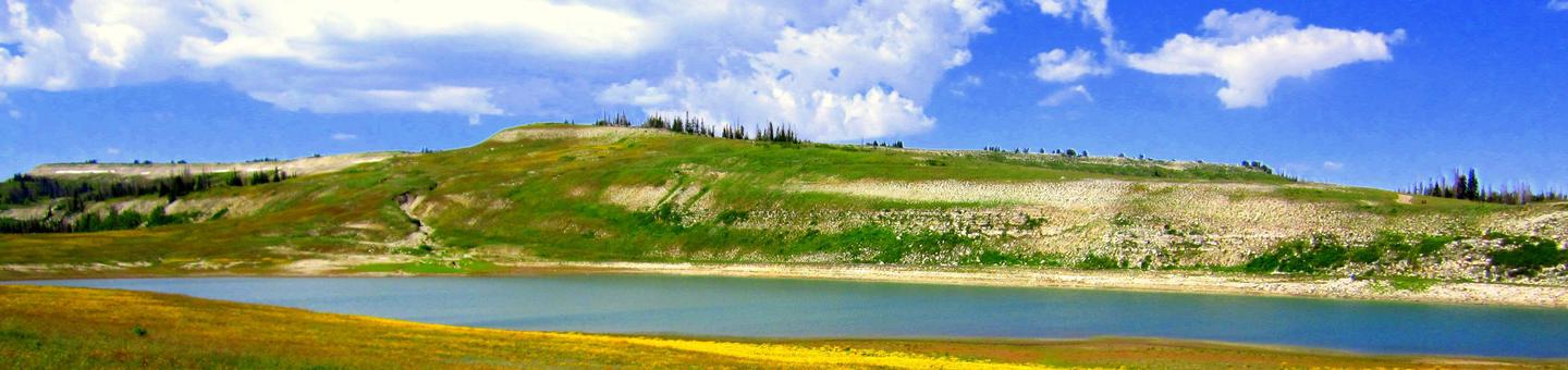
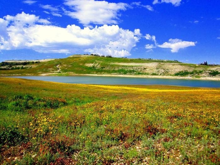
Flat Canyon Campground is located high on the Wasatch Plateau, at an elevation of 8,800 feet. The site is conveniently located near Electric Lake, where visitors enjoy boating and fishing.Recreation
A trail leads from the campground to small Boulger Reservoir, directly below the site. Electric Lake is approximately one mile away. Boating, fishing, hiking, biking and scenic driving are popular activities in the area.Facilities
The campground contains one group site that can accommodate up to 50 people. Several single-family campsites are available within the campground as well. Picnic tables and fire rings are provided, as are vault toilets.Natural Features
The campground is situated on a hillside above the highway. Hundreds of hazardous trees have been removed from the site, opening up the canopy and reducing shade to a minimum. Several large spruce trees remain, however, and grasses and summer wildflowers are abundant in the area.OLD FOLKS FLAT Campground
List of CampsitesOverview
Old Folks Flat Campground is nestled in beautiful Huntington Canyon along the Huntington Canyon National Scenic Byway on Utah Highway 31. It sits at an elevation of 8,600 feet. Many recreational activities are available, including hiking, biking and fishing. This small campground is accessible by paved road by all types of passenger vehicles.
Recreation
Popular activities include fishing, hunting, hiking, mountain biking, horseback riding, rock climbing and scenic driving. Nearby Huntington Creek is a Blue Ribbon fishery, offering high-quality fishing for brown, cutthroat and rainbow trout.The 4-mile Left Fork of the Huntington National Recreation Trail is nearby and open to hikers and horseback riders. The 10-mile Fish Creek Trail, for hiking, biking and horseback riding, is also close by.
Facilities
This campground is primarily devoted to group sites, but eight single-family campsites are also available. The five group sites can accommodate up to 20, 50 or 60 people and multiple vehicles in adjacent parking areas.Sites are equipped with tables and and a campfire rings with grills. The facility has recently been upgraded with flush toilets and drinking water spigots, but electricity and garbage collection service is not available. Roads and parking spurs within the campground are gravel.
Natural Features
Large spruce trees and aspens cover the campground, offering partial shade. The canyon area has numerous lakes and streams, vibrant summer wildflowers, colorful fall foliage and abundant wildlife. Located just across W State Road 31 is Huntington Creek.
Nearby Attractions
The Huntington Canyon National Scenic Byway is part of the 86-mile Energy Loop. It offers stunning mountain and lake views as it tops 10,000 feet in elevation.
The historic Stuart Guard Station Visitor Center is nearby, offering a glimpse of the 1930s life of a ranger and his family who once lived there. Exhibits of Civilian Conservation Corps projects and original equipment are also on display. Area information is available there as well.
The Bridges Campground, Little Rock Campground, and Huntington Creek are also close by.
JOES VALLEY RESERVOIR Campground
List of CampsitesOverview
Joe's Valley Reservoir Campground is located in a high mountain valley next to its namesake, at an elevation of 7,000 feet. Visitors enjoy boating, fishing and exploring the surrounding off-road vehicle trails. A paved road winds around the lake but quickly turns to dirt once the elevation begins to increase.
Recreation
The reservoir offers good fishing for cutthroat trout, rainbow trout, tiger muskie and trophy splake. Boating, water skiing and canoeing are popular on the lake. A boat ramp is located nearby on the eastern shoreline. Horseback riding, bouldering, hiking and mountain biking are popular in the area as well.Facilities
The campground contains several single and double-family campsites, all of which are accessible. Many sites have lake views and some sites are shaded. Vault toilets and drinking water are provided. Roads and parking spurs are paved. Boat ramps can be found nearby for easy lake access.
Natural Features
Joe's Valley is situated on the Wasatch Plateau in Central Utah. Juniper, pinyon pine and sagebrush cover the area, and aspens and pines dot the surrounding hillsides. Located on a reservoir, there is nearby access to Seely Creek, Littles Creek, North Dragon Creek, and Lowry Water.
Nearby Attractions
Renowned bouldering opportunities are located in nearby Straight and Cottonwood Canyons. Popular mountain fisheries at Grassy Lake, Pete's Hole, and Potters Ponds are all within 10 miles of the group site. The 370-mile Arapeen Off-Highway Vehicle Trail System can be accessed directly from the Reeder Trailhead, which includes 66 and 55-inch OHV trails. Attractions at Joe's Valley Reservoir include the Orange Olsen Guard Station cabin rentals, and Joe's Valley Group Pavilion.
DEVILS CANYON Campground
List of CampsitesOverview
Devils Canyon Campground sits in the Manti-LaSal National Forest of southeast Utah at the foot of the Abajo Mountains.
There is water available seasonally from June to September.
Recreation
Several miles of off-road vehicle trails crisscross the Abajo Mountains. The Camp Jackson/Wagon Wheel Trail can be accessed nearby.The Abajo Loop State Scenic Backway passes by the campground. It leads from the desert floor and red rock canyons to steep mountains over 10,000 feet high, with overlooks and panoramic views. The byway is suitable for passenger vehicles from late spring through fall but is not recommended for large RVs.
Facilities
The campground contains numerous single-family sites with picnic tables and fire rings. Vault toilets and drinking water (seasonal) are provided. Showers are available eight miles south in Blanding. Firewood is limited. Parking spurs are paved. Sites # 1-5 and 8-16 are accessible and have paved areas around the fire pit and picnic table. Sites # 6 & 7 have short trails from parking spur to paved camping area and are not considered accessible. There is a 14 day stay limit at this campground.
Natural Features
Ponderosa pines, pinyon pines and juniper cover the area, offering limited shade. The campground sits at an elevation of 7,400 feet, and summer temperatures are warm in the day and cool in the evening. Birds, squirrels, chipmunks, mule deer and black bear may be seen in the area.Nearby Attractions
Popular attractions in the area include Canyonlands, Arches and Mesa Verde National Parks, Dark Canyon Wilderness, Edge of the Cedars State Park, Lake Powell and numerous archaeological sites.Evening programs are provided at Edge of the Cedars Museum in Blanding. The San Juan County Fair is held annually in August in Monticello.
WARNER LAKE Campground
List of CampsitesOverview
Warner Lake Campground and Cabin are located high in the La Sal Mountains at an elevation of 9,400 feet, next to beautiful Warner Lake. Visitors enjoy fishing, canoeing, kayaking and exploring many local trails.
Recreation
The lake offers rainbow trout fishing, canoeing and kayaking. An extensive trail system is located around Warner Lake, encompassing the Trans-Mountain Trail, Miners Basin Trail, Warner Lake-Oowah Lake Trail, Burro Pass Trail and Dry Fork-Beaver Basin Trail. A trailhead is located in the campground, and many others are available in the surrounding area.Facilities
Warner Lake boasts a campground and a rustic cabin. The campground contains one group site that can accommodate up to 50 people; several single-family sites are also available. Picnic tables, campfire rings and utility tables are provided, as are vault toilets. Roads and parking spurs within the site are gravel.
The two-room cabin can sleep four people on two sets of bunk beds with mattresses. Linens and bedding are not provided.
The kitchen is equipped with a propane stove/oven, solar powered lighting, table and chairs. and patio furniture. While the cabin has basic kitchenware, guests are encouraged to bring their own cooking supplies including basic staples and water. A picnic table, campfire ring and vault toilet are located outside the cabin.
There is a 14 day stay limit at this campground.
Natural Features
A dense forest of aspens provides partial shade and spectacular autumn color. The lake and precipitous, 11,634' Haystack Mountain are visible from a few campsites and the front porch of the cabin. Short foot trails lead to the shore.Nearby Attractions
Arches and Canyonlands National Parks are close enough to Warner Lake for a day trip. Both parks contain breathtaking desert scenery, natural sandstone arches and numerous hiking trails.The town of Moab is less than 30 miles away, offering a range of dining and shopping options, galleries, grocery stores, gas stations, rafting outfitters and Jeep rentals. The drive to Moab, although 30 miles, takes about an hour to reach due to the mountainous, windy, gravel roads.
contact_info
For facility specific information, please call (435) 259-7155.NIZHONI Campground
List of CampsitesOverview
Nizhoni Campground sits in the Manti-LaSal National Forest in southeast Utah, at the foot of the Abajo Mountains.
Recreation
Popular activities include hiking, wildlife viewing and off-road vehicle riding. Several trailheads are nearby, including Shay Ridge, Aspen Flat and Red Ledges.The Abajo Loop State Scenic Backway passes by the campground. It leads from the desert floor and red rock canyons to steep mountains over 10,000 feet high, with overlooks and panoramic views. The byway is suitable for passenger vehicles from late spring through fall but is not recommended for large RVs.
Facilities
The campground contains two group sites that each accommodate up to 50 guests. Several single-family sites are available as well. Picnic tables and fire rings are provided, as are vault toilets and drinking water seasonally. Firewood may be collected in and around the campground. Roads and parking spurs are gravel. There is a 14 day stay limit at this campground.
Natural Features
Towering Ponderosa pines forest the site, offering partial shade. Gambel oaks and sagebrush dot the landscape. The campground sits at an elevation of 7,000 feet, and summer temperatures range from 80-90 degrees during the day and 55-65 degrees at night.Mule deer, wild turkeys, Abert's squirrels and the occasional black bear may be seen in the area.
Nearby Attractions
Other attractions in the area include Canyonlands, Arches and Mesa Verde National Parks, Dark Canyon Wilderness, Edge of the Cedars State Park, Lake Powell and numerous archaeological sites.BUCKBOARD Campground
List of CampsitesOverview
Buckboard Campground sits in the Manti-LaSal National Forest in southeast Utah at the foot of the Abajo Mountains. Visitors enjoy fishing and exploring local trails.Recreation
Popular activities include fishing, hiking and off-road vehicle riding. Several trailheads are nearby, including Robertson's Pasture Trail and Spring Creek Trail. The Abajo Loop State Scenic Backway passes by the campground. It leads from the desert floor and red rock canyons to steep mountains over 10,000 feet high, with overlooks and panoramic views. The byway is suitable for passenger vehicles from late spring through fall but is not recommended for large RVs.Facilities
The campground offers several single-family sites, as well as two group sites than can each accommodate up to 50 guests. Firewood may be collected in and around the campground. Forest Road 105 to the campground is paved, while parking spurs and the road within the campground are graveled. There are two vault toilets and the campground has water available (seasonally.) There is a 14 day stay limit at this campground.
Natural Features
Aspens and Gambel oaks surround the site, offering partial shade. The campground sits at an elevation of 8,900 feet, and summer temperatures range from 75-85 degrees during the day and 50-60 degrees at night. Mule deer, wild turkeys and black bears frequent the area.Nearby Attractions
Other attractions in the area include Canyonlands, Arches and Mesa Verde National Parks, Natural Bridges National Monument, Dark Canyon Wilderness, Edge of the Cedars State Park, Lake Powell and numerous archaeological sites.MANTI COMMUNITY Campground
List of CampsitesOverview
Manti Community Campground is just 7 miles east of Manti, Utah next to Yearns Reservoir at an elevation of 7,400 feet. Visitors enjoy fishing, canoeing and exploring local trails. Accessible by dirt road, no high clearance needed.
Recreation
Canoeing and fishing for rainbow and cutthroat trout are popular activities on the small but scenic man-made reservoir. A short, easy trail traverses around Yearns Reservoir with fishing access points on the north, west, and south sides of the lake. The trail includes a wooden bridge, two stream crossings, a set of wooden stairs, and both shaded and exposed areas. Hiking, mountain biking and horseback riding are also favorite activities in the area.
Facilities
The campground contains one group site that can accommodate up to 30 people and six vehicles. Single-family sites are available as well. Multiple vault toilets are provided, along with access footpaths leading down to Yearns Reservoir. Roads and parking spurs are gravel.
Natural Features
A mixed forest of spruce, pinyon, juniper, fir and aspen covers the area, offering partial shade. Wildlife and summer wildflowers are abundant. Situated on a hill above Yearns Reservoir with multiple access trails.
Nearby Attractions
The surrounding area is a haven for ATV enthusiasts. Several trails, primarily for 66-inch OHVs, crisscross the region, making up part of the 350-plus miles of the exciting Arapeen OHV Trail System. In the immediate area is the Burnt Hill Trail that connects with the Patton Trail, beginning at the Manti Loop Patton Trailhead. Milky Falls can also be found nearby.
GOOSEBERRY RESERVOIR Campground
List of CampsitesOverview
Gooseberry Reservoir Campground is located in a scenic mountain valley in an open meadow next to Gooseberry Reservoir. It is situated at an elevation of 8,400 feet. Visitors enjoy canoeing and fishing on the small reservoir and exploring area trails.Recreation
The reservoir offers good cutthroat and rainbow trout fishing, as well as canoeing. It is open to hand-powered watercraft only, and no boat ramp is available on the lake.
The Great Western Trail runs next to the campground, offering excellent opportunities for hiking, biking and off-road vehicle riding. Mammoth Guard Station is located just one mile south.
Facilities
The campground contains several standard RV sites with long parking spurs that easily accommodate large RVs. Vault toilets are provided, but no water or garbage service is available. A well-maintained dirt road leads to the campground, providing relatively easy access for cars and RVs alike.Natural Features
The surrounding mountains are dotted with aspens, fir trees and sagebrush, but the campground has no trees and no shade. Each site has a nice lake view. Grasses and summer wildflowers cover the valley.TWELVE MILE FLAT Campground
List of CampsitesOverview
Twelve Mile Flat Campground is located beneath the shadow of Mt. Baldy near the top of the Wasatch Plateau in an open, wildflower-filled meadow surrounded by spruce and pines.Recreation
ATV trails are abundant in the area, providing exciting riding for all skill levels. Skyline Drive passes just above the campground.A short, but steep drive over the ridge leads to Ferron Reservoir for canoeing and rainbow and cutthroat trout fishing.
Facilities
The campground contains two group sites that can accommodate up to 50 people and eight vehicles each. Additional single-family sites are also available. Vault toilets are provided, but no garbage service. Roads and parking spurs are gravel.Natural Features
The campground sits high on the Wasatch Plateau just below the ridgeline and west of Skyline Drive at an elevation of 10,120 feet. Mature spruce and pine trees dot the open landscape, providing partial shade in the campground. Wildlife and summer wildflowers are plentiful, and autumn leaves put on a spectacular show in the surrounding area.Nearby Attractions
Skyline Drive runs along the top of the Wasatch Plateau for 60 plus miles, rewarding visitors with beautiful mountain scenery, glacial cirques, spruce-fir forests, aspen forests and numerous lakes and reservoirs.LAKE HILL Campground
List of CampsitesOverview
Lake Hill Campground is situated next to pretty Lake Hill Reservoir just five miles from Ephraim, Utah at an elevation of 8,400 feet. Visitors enjoy fishing, canoeing and exploring local trails.Recreation
Canoeing and rainbow trout fishing are popular activities on the small but scenic man-made reservoir.Facilities
The campground contains two groups sites: GP1 is located on a hillside above the lake, but the lake is not visible; GP3 is next to the lake and offers scenic views. However, expect high volumes of traffic near GP3 Additional single-family sites are available as well, most of which are below the lake. Vault toilets and drinking water are provided. Roads and parking spurs are dirt.Natural Features
A mixed forest of spruce, fir and aspen covers the area, offering partial shade in most sites, with some more exposed than others. Summer wildflowers and wildlife are abundant.Nearby Attractions
Ephraim Canyon is a haven for ATV enthusiasts. Several trails crisscross the region, making up part of the 350 plus miles of the exciting Arapeen OHV Trail System. Jimmies Fork Trail and the Great Basin Experimental Trail begin nearby, offering hiking, mountain biking and horseback riding opportunities.The self-guided Great Basin Experimental Range Auto Tour runs along Ephraim Canyon, offering a glimpse into the history and workings of one of North America's oldest range research sites.
FORKS OF HUNTINGTON Campground
List of CampsitesOverview
Forks of Huntington Campground is located in beautiful Huntington Canyon, along the Huntington Canyon National Scenic Byway on Utah Highway 31. It is situated at an elevation of 7,600 feet. Many recreational activities are available, including hiking, biking and fishing.Recreation
The Left Fork of the Huntington is a Blue Ribbon fishery, offering high quality fishing for brown, cutthroat and rainbow trout. The creek joins the main Huntington Creek just below the campground.Popular activities enjoyed by visitors to the area include fishing, hunting, hiking, mountain biking, horseback riding, rock climbing and scenic driving.
The 4-mile Left Fork of the Huntington National Recreation Trail begins in the campground. It is open to hikers and horseback riders. The 10-mile Fish Creek Trail, for hiking, biking and horseback riding, also begins nearby.
Facilities
The campground offers two single-family campsites, as well as one large-group campsite that can accommodate up to 40 people. Vault toilets are located throughout the campground.
Garbage collection facilities are not provided, requiring visitors to carry out all trash. Roads and parking spurs within the campground are graveled.
Natural Features
Thick stands of pine trees within the campground offer plentiful shade, and the Left Fork of Huntington Creek runs through the campground. The canyon area has numerous lakes and streams, vibrant summer wildflowers, colorful fall foliage and abundant wildlife.Nearby Attractions
The Huntington Canyon National Scenic Byway is part of the 86-mile Energy Loop. It offers stunning mountain and lake views as it tops 10,000 feet in elevation.The historic Stuart Guard Station Visitor Center is nearby, offering a glimpse of the 1930s life of a ranger and his family who once lived there. Exhibits of Civilian Conservation Corps projects and original equipment are also on display. Area information is available as well.
MAPLE CANYON Campground
List of CampsitesOverview
Maple Canyon Campground is known for its unique cliffs, arches, and scenic views of the Sanpitch Mountains. It is a small campground nestled between towering conglomerate rock walls on either side of the canyon. A favorite among rock climbers, notably for a formation called The Pipe Dream, the campground is just 3 miles from Freedom, Utah.
Recreation
Rock climbing is the campground's main draw, attracting climbers from all over the world with its numerous routes for beginners and experts alike.Over 140 bolted routes are available with climbing grades from 5.4 to 5.14.
Facilities
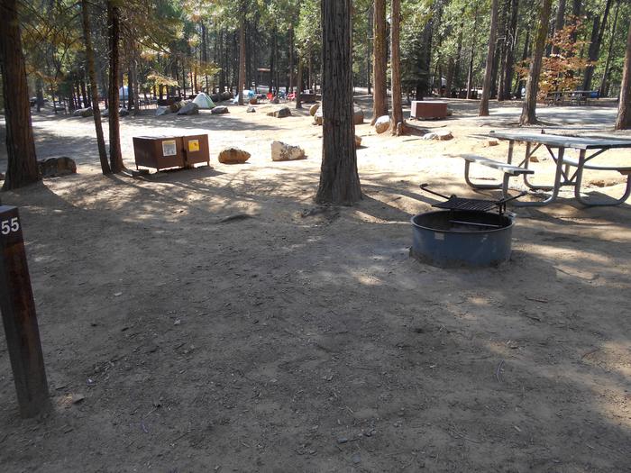
The campground contains one group site and several single-family sites. Sites 2, 3 and 4 are walk-to tent sites that must be accessed by carrying gear a short distance from the parking area. Vault toilets are provided but there is no water. Roads and parking spurs are dirt. Accessible by all passenger vehicles.
Natural Features
The campground is nestled among thick groves of maples below beautiful, towering conglomerate walls at an elevation of 6,700 feet. The canyon contains over 40 cliffs ranging in height from 30 to 300 feet. A variety of wildlife makes its home in the canyon.Nearby Attractions
The canyon offers some excellent hiking, biking and horseback riding opportunities. Three steep scenic loop trails (three to five-mile loops) provide access to many of the rock climbing sites in the canyon, such as the famous Pipe Dream tunnel. Panoramic views east into Sanpete Valley and beyond to the Wasatch Plateau reveal themselves near the tops of the trails and cliffs. The Sanpitch Recreation Area and Chicken Creek Campground can be found nearby.
FERRON RESERVOIR Campground
List of CampsitesOverview
Ferron Campground is located next to Ferron Reservoir, a premier alpine lake that is popular with fishermen. The area offers both developed single campsites and a developed group camp site. It sits just below the ridgeline of the Wasatch Plateau, at an elevation of 9,400 feet. It is located adjacent to the historical Indian Creek Guard Station. Visitors enjoy fishing, canoeing and exploring many local trails.
Recreation
Ferron Reservoir is adjacent to the campground, providing canoeing, boating (small craft only) and fishing for rainbow and cutthroat trout. Numerous off-road vehicle trails crisscross the area, offering exciting rides for all skill levels. These trails mainly consist of 66-inch and 50-inch OHV routes. Rush Pond and Willow Lake are a short drive east and Duck Fork Reservoir is just to the north, offering additional fishing, canoeing, and OHV opportunities.
Facilities
The campground contains one group campsite offering lake views, located on the northeast portion of the lake. It can accommodate up to 50 people and eight vehicles. Several single-family sites are also available within the campground, located to the south and west of the lake. Vault toilets and drinking water are provided, but there is no garbage service. Multiple self-pay fee stations are available. Roads and parking spurs are gravel.
Natural Features
The small reservoir sits in a scenic alpine basin. Spruce, fir and aspen trees dot the landscape, providing partial shade in the campground. Wildlife and summer wildflowers are abundant, and autumn leaves put on quite a show in the surrounding area.Nearby Attractions
Skyline Drive runs above the campground, along the top of the Wasatch Plateau for more than 60 miles, rewarding visitors with beautiful mountain scenery, glacial cirques, spruce-fir and aspen forests and numerous lakes and reservoirs.The expansive Arapeen OHV Trail System can be accessed nearby and has more than 350 miles of designated, maintained trails suitable for all riding levels.
INDIAN CREEK (UT) Campground
List of CampsitesOverview
Indian Creek Campground is located in a high mountain valley surrounded by beautiful peaks, at an elevation of 8,000 feet. Visitors enjoy exploring the area trails on foot, and by horse and on off-road vehicles.Recreation
Horseback riding, hiking and mountain biking are popular activities in the Indian Creek area. Many trails crisscross the surrounding valley and mountainsides.Facilities
The campground contains seven large, group-sized campsites that can accommodate from 30 to 70 people. Vault toilets and drinking water are provided, but no electricity or garbage service are available within the campground.Roads and spurs within the campground are dirt. It can be reached via the well-maintained dirt and gravel Cottonwood Creek Road, which providing relatively easy access for cars and RVs.
Natural Features
Indian Creek is situated in Upper Joe's Valley, on the Wasatch Plateau in Central Utah. A grove of aspens forests the site, offering only limited shade, but bright autumn color. Sagebrush and pines dot the landscape.Nearby Attractions
Potters Pond is nearby, offering great canoeing and rainbow trout fishing.The expansive Arapeen OHV Trail System can be accessed close by and has more than 350 miles of designated, well-maintained trails for off-road vehicles. Trails there are suitable for all riding levels.
Gooseberry Creek Campground Campground
List of CampsitesOverview
Gooseberry Group Campground is located on an aspen-covered hillside above Gooseberry Reservoir, at an elevation of 8,500 feet. Visitors enjoy fishing and canoeing on the small reservoir and exploring area trails.Recreation
Gooseberry Reservoir, which is visible from several sites, offers good cutthroat and rainbow trout fishing, as well as canoeing. The Great Western Trail runs near the campground, offering excellent opportunities for hiking, biking and off-road vehicle riding.Facilities
The campground offers group campsites equipped with picnic tables and fire rings. Vault toilets and drinking water are provided. Garbage collection facilities are not available, requiring visitors to pack out all trash.A well-maintained dirt road leads to the campground, providing relatively easy access for cars and RVs alike.
Natural Features
The campground lies within a grove of aspens that is dotted with mature fir trees, in a valley high on the Wasatch Plateau. Some campsites are sunny with little tree cover, while some have ample shade. Sagebrush, grasses and summer wildflowers fill the scenic valley.Nearby Attractions
JOES VALLEY PAVILION GROUP SITE A Campground
List of CampsitesOverview
Joes Valley Pavilion Group Site is located in a high mountain valley just above Joes Valley Reservoir, at an elevation of 7,000 feet. Visitors enjoy boating, fishing, and exploring surrounding off-road vehicle trails.Recreation
The reservoir offers good fishing for cutthroat trout, rainbow trout, tiger muskie and trophy splake. Boating, water skiing and canoeing are popular on the lake. A boat ramp is located nearby on the eastern shoreline. Horseback riding, bouldering, hiking and mountain biking are popular in the area as well.Facilities
The group campsite can accommodate up to 100 people. A large pavilion offers shade over the picnic tables only. Vault toilets and water are provided, but no electricity is available within the group site. A large gravel parking area provides ample space for vehicles, RVs, trailers and tents.Natural Features
Joes Valley is situated on the Wasatch Plateau in Central Utah. Sagebrush covers the area. A few cottonwoods line the lakeshore and aspens and pines dot the surrounding hillsides. There are no trees or natural shade in the immediate area of the campground.Nearby Attractions
Renowned bouldering opportunities are located in nearby Straight and Cottonwood Canyons. Popular mountain fisheries at Grassy Lake, Pete's Hole, and Potters Ponds are all within 10 miles of the group site. The 370-mile Arapeen Off-Highway Vehicle Trail System can be accessed directly from the Reeder Trailhead. Attractions at Joes Valley Reservoir include the Orange Olsen Guard Station rental, and Joes Valley Campground.INDIAN CREEK GUARD STATION Campground
List of CampsitesOverview
Indian Creek Guard Station is located next to Ferron Reservoir, just below the Wasatch Plateau on the Manti-La Sal National Forest in central Utah. The cabin was built by the Civilian Conservation Corps in the 1930s and was used by generations of forest rangers serving in the back country.Guests enjoy year-round recreational activities, including fishing, hiking, off-roading, snowmobiling and skiing.
Recreation
Ferron Reservoir is adjacent, providing canoeing, boating (small craft only) and fishing for rainbow and cutthroat trout. Skyline Drive passes above the campground on top of the plateau.The expansive Arapeen ATV Trail System can be accessed close by, and offers more than 350 miles of designated, maintained trails suitable for all riding levels.
In the winter, the surrounding area becomes a playground for snowmobile enthusiasts. Cross-country skiing, back country skiing and snowshoeing are also popular activities.
Facilities
The guard station complex can accommodate a maximum of 10 people, with six inside and four camped in tents outside of the facility. RVs are not allowed. The guard station contains single bunks with mattresses for four people. Guests must bring their own linens, bedding and pillows. The kitchen is equipped with a table and chairs, sink, wood stove, propane lighting and propane appliances, including a stove and oven and hot water heater. Limited utensils and cookware are available but guests are encouraged to bring their own supplies and matches. Drinking water and an indoor flush toilet and shower are available from July through mid-September. A vault toilet is available 50 feet from the cabin during the winter months.Natural Features
The guard station is situated facing Ferron Reservoir and the front porch offers partial lake views through the trees. Stands of Englemann spruce, fir and aspens cover the area.Skyline Drive runs along the top of the Wasatch Plateau for more than 60 miles, rewarding visitors with beautiful mountain scenery, glacial cirques, spruce-fir and aspen forests, numerous lakes and reservoirs. Wildlife and summer wildflowers are plentiful, and autumn leaves put on quite a show.
Due to the guard station's high elevation of 9,400 feet, guests should be prepared for all types of weather including snow or hail, especially after September.
Nearby Attractions
Ferron Campground is located less than a half-mile away from the guard station. Rush Pond and Willow Lake are a short drive east, both with additional fishing and scenic views.SEELY CREEK GUARD STATION Campground
List of CampsitesOverview
Seely Creek Guard Station is located near the top of the Wasatch Plateau, within the Manti-La Sal National Forest in central Utah. The cabin was built in late-1907 or early-1908 and is listed on the National Register of Historic Places. Guests enjoy year-round recreational activities, including hiking, off-roading, snowmobiling and skiing.Recreation
Skyline Drive passes along the ridge line just above the cabin, providing great trail opportunities for off-road vehicles, mountain biking and hiking. In the winter, the surrounding area becomes a playground for snowmobile enthusiasts. Cross-country skiing, back country skiing and snowshoeing are also popular activities.Horseback riding trails crisscross the area as well. A maximum of 20 horses is allowed at the guard station, though no horse facilities (corrals, hitching posts, etc) are present. The surrounding meadow can be used for picketing or hobbling.
Facilities
Seely Guard Station can accommodate a maximum of 30 people, with six inside and 24 camped outside in a maximum of six vehicles (truck and trailer combination counts as one vehicle). The rustic guard station is spacious inside, with four single bunks without mattresses. Guests must bring their own linens, bedding and pillows.The cabin is equipped with a table and chairs, a fireplace and wood stove. No water is available. A vault toilet is located approximately 50 feet behind the cabin and a campfire ring lies outside the fenced area on the north side.
Natural Features
The cabin is situated in a beautiful wildflower-filled meadow, at an elevation of approximately 10,000 feet. Seely Creek flows along the edge of the meadow.Skyline Drive runs along the top of the Wasatch Plateau for more than 60 miles, rewarding visitors with beautiful mountain scenery, glacial cirques, spruce-fir and aspen forests, numerous lakes and reservoirs. Wildlife and summer wildflowers are plentiful, and autumn leaves put on quite a show.
Due to the guard station's high elevation, guests should be prepared for all types of weather including snow or hail, especially after September.
Nearby Attractions
John August Lake is less than three miles from the guard station, with fishing and scenic high alpine views. Pete's Hole and Soup Bowl are less than eight miles away, offering fishing and a hiking trail.TWIN LAKE CAMPGROUND Campground
List of CampsitesOverview
Twin Lake Campground rests in a juniper tree belt between the lower river bottom of Twelve Mile Canyon and the upper sub-alpine top of Skyline Drive. Visitors enjoy exploring a wealth of off-road vehicle trails.Recreation
With an off-road vehicle learner loop in the campground and a central location between trails connecting to the Arapeen OHV Trail system and Skyline Drive, Twin Lake is the perfect staging area for exciting riding at any skill level.Facilities
The campground contains one group site available for online reservations. This site accommodates up to 40 people and six vehicles. An additional 21 single-family sites are available, two of which, Sites 11 and 13, are open for online reservations.Campfire rings are provided in each campsite and two vault toilets are regularly maintained and accessible within the campground. There is no trash collection so be prepared to pack out what you bring in.
Natural Features
The campground is located 7 miles up Twelve Mile Canyon from the town of Mayfield Utah, nestled among Flagstaff Limestone bluffs. At 7,000 feet above sea level, Twin Lake Campground allows early access in the spring and warmer temperatures in the fall.
Nearby Attractions
The Arapeen OHV Trail System offers extensive riding. Access to Skyline Drive rewards visitors with picturesque scenery and outdoor excitement.CHUTE GROUP Campground
List of CampsitesOverview
Chute Group Campground is located in beautiful Huntington Canyon, along the Huntington Canyon National Scenic Byway on Utah Highway 31. It is situated at an elevation of approximately 8,000 feet. Many recreational activities are available, including hiking, biking and fishing.Recreation
Popular activities enjoyed by visitors to the area include fishing, hunting, hiking, mountain biking, horseback riding, rock climbing and scenic driving. Huntington Creek is a Blue Ribbon fishery, providing high quality fishing for brown, cutthroat and rainbow trout.The 4-mile Left Fork of the Huntington National Recreation Trail is nearby and open to hikers and horseback riders. The 10-mile Fish Creek Trail, for hiking, biking and horseback riding is also close by.
Facilities
The campground offers one large group campsite that can accommodate up to 50 people. An accessible vault toilet is provided, but there is no drinking water, electricity, or garbage removal service. The large parking area within the campground is dirt. Grassy areas located throughout the site provide nice spots for tents.
Natural Features
Large spruce trees offer shade throughout the site. Grassy meadows and thick stands of willow trees line Huntington Creek, which flows next to the campground. The canyon area has numerous lakes and streams, vibrant summer wildflowers, colorful fall foliage, and abundant wildlife.
Nearby Attractions
The Huntington Canyon National Scenic Byway is part of the 86-mile Energy Loop. It offers stunning mountain and lake views as it tops 10,000 feet in elevation.The historic Stuart Guard Station Visitor Center is nearby, offering a glimpse of the 1930s life of a ranger and his family who once lived there. Exhibits of Civilian Conservation Corps projects and original equipment are on display. Area information is available there as well.
BIG ROCK GROUP Campground
List of CampsitesOverview
Big Rock Group Campground is located in beautiful Huntington Canyon, along the Huntington Canyon National Scenic Byway on Utah Highway 31. It is situated at an elevation of 7,600 feet. Many recreational activities are available, including hiking, biking and fishing.Recreation
Popular activities enjoyed by visitors to the area include fishing, hunting, hiking, mountain biking, horseback riding, rock climbing and scenic driving. Huntington Creek is a Blue Ribbon fishery, providing high quality brown, cutthroat and rainbow trout.
The 4-mile Left Fork of the Huntington National Recreation Trail is nearby and is open to hikers and horseback riders. The 10-mile Fish Creek Trail, used for hiking, biking and horseback riding, is also close by.
Facilities
The campground provides one large group campsite that can accommodate up to 50 people. A large gravel parking area provides ample room for RVs of any size. Accessible vault toilets are provided, but drinking water is not available at the campground. Visitors are asked to carry out all garbage as there are ano waste disposal services available.
Natural Features
Huntington Creek flows alongside the campground. Pine and fir trees line the edges surrounding the campground, but offer little shade within the site. The surrounding area has numerous lakes and streams, vibrant summer wildflowers, colorful fall foliage and abundant wildlife.Nearby Attractions
The Huntington Canyon National Scenic Byway is part of the 86-mile Energy Loop. It offers stunning mountain and lake views as it tops 10,000 feet in elevation.The historic Stuart Guard Station Visitor Center is nearby, offering a glimpse of the 1930s life of a ranger and his family who once lived there. Exhibits of Civilian Conservation Corps projects and original equipment are on display there. Area information is available as well.
LITTLE BEAR GROUP Campground
List of CampsitesOverview
Little Bear Group Campground is located in beautiful Huntington Canyon along the Huntington Canyon National Scenic Byway on Utah Highway 31. It sits at an elevation of approximately 6,500 feet. Many recreational activities are available, including hiking, biking and fishing.Recreation
Popular activities include fishing, hunting, hiking, mountain biking, horseback riding, rock climbing and scenic driving. Huntington Creek is a Blue Ribbon fishery, offering high quality fishing for brown, cutthroat and rainbow trout.The 4-mile Left Fork of the Huntington National Recreation Trail is nearby and open to hikers and horseback riders. The 10-mile Fish Creek Trail, for hiking, biking and horseback riding is also near the campground.
Facilities
Little Bear Group Campground is made up of two large-group campsites, for tent and RV camping. To reserve the entire campground, both sites (A and B) must be reserved at the same time. Each site can accommodate up to 50 people and 15 vehicles. Adjacent parking areas are dirt.The campsites are equipped with tables and campfire rings with grills. Vault toilets are provided. Utility hookups are not available. Drinking water and trash collection facilities are not available at the campground. Visitors should bring their own water and pack out all garbage.
Natural Features
Pines and junipers offer plentiful shade and Huntington Creek runs alongside the campground. The canyon area has numerous lakes and streams, vibrant summer wildflowers, colorful fall foliage and abundant wildlife.Nearby Attractions
The Huntington Canyon National Scenic Byway is part of the 86-mile Energy Loop. It offers stunning mountain and lake views as it tops 10,000 feet in elevation.The historic Stuart Guard Station Visitor Center is nearby, offering a glimpse of the 1930s life of a ranger and his family who once lived there. Exhibits of Civilian Conservation Corps projects and original equipment are also on display. Area information is available there as well.
BRIDGES CAMPGROUND Campground
List of CampsitesOverview
Bridges Campground is located in beautiful Huntington Canyon, along the Huntington Canyon National Scenic Byway on Utah Highway 31. It is situated at an elevation of approximately 8,700 feet. Many recreational activities are available, including hiking, biking, scenic driving, and fishing.
Recreation
Popular activities include fishing, hunting, hiking, mountain biking, horseback riding, rock climbing and scenic driving. Huntington Creek is a Blue Ribbon fishery, offering high quality fishing for brown, cutthroat and rainbow trout.The 4-mile Left Fork of the Huntington National Recreation Trail is nearby and open to hikers and horseback riders. The 10-mile Fish Creek Trail, for hiking, biking and horseback riding is also close by. Although horses are not allowed in the campground, two hitching racks are provided just across the highway.
Facilities
The campground offers one group campsite that can accommodate groups of up to 30 people. Four single-family campsites are also available. Vault toilets are provided, but there is no drinking water or electricity. There are no garbage services offered within the campground, so be prepared to "pack it in and pack it out". Roads and parking spurs are dirt.
Natural Features
Large spruce trees and aspens cover the campground, offering plentiful shade. Huntington Creek runs alongside the campground. The canyon area has numerous lakes and streams, vibrant summer wildflowers, colorful fall foliage and abundant wildlife.Nearby Attractions
The Huntington Canyon National Scenic Byway is part of the 86-mile Energy Loop. It offers stunning mountain and lake views as it tops 10,000 feet in elevation.The historic Stuart Guard Station Visitor Center is nearby, offering a glimpse of the 1930s life of a ranger and his family who once lived there. Exhibits of Civilian Conservation Corps projects and original equipment are on display. Area information is available as well.
POTTERS POND Campground
List of CampsitesOverview
Potters Pond Campground is located in a high mountain valley next to two scenic ponds, at an elevation of 8,900 feet. Visitors enjoy fishing, canoeing, horseback riding and exploring the surrounding off-road vehicle trails.Recreation
The ponds offer great canoeing and rainbow trout fishing. Horseback riding, hiking and mountain biking are popular in the area as well.The expansive Arapeen OHV Trail System can be accessed from the campground and has more than 350 miles of designated, well-maintained trails for off-road vehicles. The trails are suitable for all riding levels.
Facilities
This campground offers a variety of campsites, including single, double and equestrian sites. Some sites have views of the ponds and most sites are shaded.Sites are equipped with tables and campfire rings with grills. Vault toilets are provided, but there is no water, electricity or trash collection available within the campground. Visitors will need to bring their own water, as well as pack out all garbage.
Roads and parking spurs within the campground are dirt. The campground can be reached via the well-maintained dirt and gravel Miller Flat Road, which provides relatively easy access for cars and RVs.
Natural Features
Potters Pond lies in Upper Joe's Valley in Central Utah. Pine trees and wild grasses cover the area, while aspens dot the surrounding mountainsides.Charges & Cancellations
A $10.00 service fee will apply if you change or cancel your reservation. Late cancellations are subject to additional fees. For full details see NRRS Reservation Policy.WILLOW LAKE Campground
List of CampsitesOverview
WIllow Lake Campground is located on the east shore of Willow Lake, at an elevation of 9,640 feet. The small lake sits in an alpine basin high on the Wasatch Plateau. Spruce, fir and aspen trees dot the open landscape, providing partial shade in the campground. Wildlife and summer wildflowers are plentiful, and autumn leaves put on quite a show in the surrounding area. This campground contains 10 single-family sites with picnic tables and campfire rings. Most sites have lake views, though none have direct lake access. A footpath leads to the shore from the campground, and another trail with easy fishing access leads all the way around the lake. Vault toilets are provided, but there is no water or garbage service. Roads and parking spurs are gravel. Visitor enjoy fishing, canoeing, wildlife viewing, mountain biking, and hiking to explore many of the surrounding trails. In winter, the area becomes a playground for snowobile enthusiasts.
Recreation
Canoeing and fishing are popular activities on the lake. A trail leads to the lakeshore from the campground. Another recently developed footpath goes around the entire lake and features four stream crossings, two bridges, and fisherman access points on all sides of the lake.
The campground is a staging area for the expansive Arapeen OHV Trail System, with more than 350 miles of designated, maintained trails for all riding levels.
Facilities
The campground contains ten single-family campsites, most of which have lake views. Sites are equipped with picnic tables and campfire rings. Vault toilets are provided at this location. This campground does not have water or garbage service so visitors will need to plan to "pack it in and pack it out". The main parking area for day use and lake access is located right next to the main road by the information kiosk and there are two additional parking areas farther west on Ferron Canyon Road. Roads and parking spurs within the campground are gravel.
Natural Features
This small lake sits in an alpine basin high on the Wasatch Plateau. Spruce, fir and aspen trees dominate the landscape on the south and east sides of the lake, providing partial shade in the campground. The north and west sides of the lakeshore are covered in grasses and wildflowers, allowing easy access to fishing areas. Wildlife and summer flowers are plentiful, and autumn leaves put on quite a show in the surrounding area.
Nearby Attractions
Ferron Reservoir is a short drive west, offering additional fishing and canoeing opportunities. Other lakes in the area include Duck Fork Reservoir and Wrigley Reservoir.
Skyline Drive runs along the top of the Wasatch Plateau for more than 60 miles, rewarding visitors with beautiful mountain scenery, glacial cirques, spruce/fir/aspen forests, and access to numerous lakes and reservoirs.
LAKE CANYON REC AREA Campground
List of CampsitesOverview
Lake Canyon Recreation Area can be found along Utah's scenic Energy Loop, on top of the Wasatch Plateau. It is located just off Highway 31, approximately 18 miles east of the town of Fairview. The recreation area is situated between Huntington and Cleveland reservoirs, at an approximate elevation of 9,000 feet. The area is a paradise for anglers and off-road vehicle enthusiasts.Recreation
Huntington Reservoir has great tiger and cutthroat trout fishing, while Cleveland Reservoir offers great fishing for rainbow trout. Both reservoirs are perfect for canoeing and kayaking, however boat ramps are not available.The extensive Lake Canyon OHV Trail System offers many miles of exciting trails and three beginner loops, making the area accessible to riders of all skill levels. Horseback riding, hiking and mountain biking are popular as well.
Electric Lake is nearby, offering boating, water skiing and fishing for tiger and cutthroat trout. A boat ramp is on-site there.
Facilities
This expansive, yet primitive recreation area contains several campsites that can accommodate groups ranging in size from 20 to 150 people. Approximately 50 additional single-family campsites are dispersed throughout the area.Vault toilets are provided, but there is no water, electricity or garbage service available within the recreation area. Visitors should bring their own water and pack out all garbage.
Natural Features
The area is situated in a broad mountain valley, surrounded by the scenic peaks of the Wasatch Plateau. Stands of aspen and pine trees provide limited shade, and grasses, sagebrush and summer wildflowers fill the meadows.BUCKEYE RECREATION AREA (CO) Campground
List of CampsitesOverview
The Buckeye Recreation Area is located adjacent to Buckeye Reservoir in Montrose County, Colorado. The area is popular for camping, OHV/ATV trails, hunting and fishing.
Note: Some GPS or driving app directions are sending people on 4WD roads or to locked gates that are on private property. If you are unfamiliar with the area, please visit our "Facility Information - Getting Here" section for instructions on the best route to get to Buckeye Reservoir before reserving.
Recreation
Recreation in the area centers around the reservoir which provides excellent opportunities for fishing and canoeing. Forest roads in the area provide for off-highway vehicle touring and the nearby state lands provide motorized trails for Off-highway vehicles and motorcycles. The La Sal Mountains are nearby which provide many hiking and biking trails.Facilities
The Buckeye Recreation Area is located adjacent to Buckeye Reservoir. The Recreation Area is spread out around the reservoir and consists of the Pioneer Campground (30 single family reservable campsites), a boat ramp for small fishing boats (5 HP motor limit and wakeless speed), a reservable group site, a day-use picnic area and 18 less developed dispersed campsites scattered around the reservoir. Campsites in the Pioneer Campground include graveled parking spurs, concrete picnic tables, fire rings, a utility table and access to vault toilets. There is a 14 day stay limit at this campground.
Natural Features
The recreation area is located in a valley at 7,600 feet in elevation and is set amongst mature stands of Ponderosa Pines. The high peaks of the La Sal Mountains are visible from much of the area. The scenic Paradox Valley and the town of Paradox, Colorado are located approximately 10 miles to the southeast.contact_info
For facility specific information, please call (435) 259-7155.Nearby Attractions
The scenic La Sal Mountains are very close to the area and provide numerous opportunities for recreation. Canyonlands and Arches National Parks are about 1.5 hour drive away from the area as well as numerous recreation opportunities around the towns of Monticello and Moab, Utah.ORANGE OLSEN Campground
List of CampsitesOverview
Orange Olsen is located at 7,000 feet with a panoramic view of Joes Valley. The dwelling and cabin offer amenities including solar powered lighting, LP range and heated shower. The dwelling can accommodate six visitors while the cabin sleeps four. These cabins do not have electricity.
Recreation
Joes Valley Reservoir offers boating and fishing opportunities just minutes away. A boat ramp is available on the east and west shorelines. Joes Valley Campground is located immediately south of Orange Olsen, with Joes Valley Group Pavilion only a mile away.Facilities
The Orange Olsen Dwelling and Cabin come equipped with flush restrooms, showers, and solar powered lights. The kitchens are equipped with sinks, stove and simple cookware (pots/pans, silverware, utensils). These facilities are not equipped with refrigerators so visitors will need to plan on cooling their perishables in other ways.
The Orange Olsen Dwelling has two bedrooms. One bedroom has two single twin sized beds with mattresses and the second bedroom has two sets of bunk beds with mattresses. You are allowed to have a boat trailer or utility trailer on site, however, it may be a tight fit if other vehicles are present. No RV/Motorhomes/Travel Trailers are permitted at this site.
The Orange Olsen Cabin has one bedroom including two sets of bunk beds with mattresses. You are allowed to have a boat trailer or utility trailer on sites. No RV/Motorhomes/Travel Trailers are permitted at this site.
Natural Features
The dwelling and cabin are set in an open sagebrush meadow interspersed with pinyon-juniper and ponderosa pine trees. There is no shade available.Nearby Attractions
Renowned bouldering opportunities abound in nearby Straight and Cottonwood Canyons. Popular mountain fisheries at Grassy Lake, Pete's Hole, and Potters Ponds are all within 10 miles of Orange Olsen. The 370-mile Arapeen Off-Highway Vehicle Trail System can be accessed directly from the dwelling and cabin.MILLER FLAT RESERVOIR CAMPGROUND Campground
List of CampsitesOverview
Miller Flat Reservoir Campground is located in a high mountain valley near Miller Flat Reservoir, at an elevation of 8,500 feet. Visitors enjoy fishing, canoeing, horseback riding and exploring the surrounding off-road vehicle trails. The campground rest in a stand of aspen and spruce trees and sites the sites range from having partial to full shade throughout the day.
Visitors are allowed to configure their vehicles and trailers as they choose within the site. Group cooking facilities are provided including picnic tables, a fire ring, dutch oven fire pan and utility tables. A vault toilet facility is located about 50 feet from the site. There is no electricity, water, sewer or garbage services. If the group site is not reserved, it is available to visitors on a first-come, first-served basis for $5.00 per vehicle per night. To maintain priority for reservations, first-come, first-served customers may only pay for two nights at a time. The three double family sites in the campground are only available on a first-come, first-served basis for $5.00 per vehicle per night.
Nearby attractions include Miller Flat Reservoir, Potters Pond, Skyline Drive, and the expansive Arapeen OHV Trail System which has more than 350 miles of designated, maintained OHV trails.
Hiking trails near this campground include the Left Fork of Hunting National Recreation Trail which is 1.5 miles north of the campground and various hiking opportunities 2 miles south in Scad Valley.
Recreation
Lake Canyon Recreation Area is located just north of the campground as is the northern trailhead of the Left Fork of Huntington National Recreation Trail. Cleveland and Huntington Reservoirs are located just minutes north of the campground along U31. Each offers trout fishing opportunities, with a boat ramp available at Huntington Reservoir.Facilities
Visitors are allowed to configure their vehicles and trailers as they choose within the site. Group cooking facilities are provided including picnic tables, a fire ring, dutch oven fire pan and utility tables. A vault toilet facility is located about 50 feet from the site. There is no electricity, water, sewer or garbage services.If the group site is not reserved, it is available to visitors on a first-come, first-served basis for $5.00 per vehicle per night. To maintain priority for reservations, first-come, first-served customers may only pay for two nights at a time. The three double family sites in the campground are only available on a first-come, first-served basis for $5.00 per vehicle per night. They are not reservable.
Natural Features
The group site is set in an open meadow with aspen and fir trees bordering the northern perimeter.Nearby Attractions
Potters Ponds, a popular trout fishery is located approximately seven miles south of the campground. The 370-mile Arapeen Off-highway Vehicle Trail System can be accessed directly from the campground by riding north or south along the Miller Flat Road. Maps are available from hosts working in the area.Monticello Lake Fishing Site Facility
The Monticello Lake Fishing Site is located next to Monticello Lake, a 5 acre lake located about 0.2 miles off FH 49 Loop/Harts Draw down Forest Road #114. The Department of Wildlife Resources of Utah (DWR) stocks this reservoir with Rainbow and Tiger Trout.
The Hole Trailhead Facility
The Hole Trailhead (TH) marks the entrance to the Hole Trail, which is ~6.6 miles in length and provides a connection between Muddy Creek Road ,just north of Emery, Utah, and Sage Flat Road/Forest Road (FR) 0315. The trailhead is at ~6400' elevation.
Grassy Lake Fishing Site Facility
Grassy Lake is a 10.7 acre lake located 2.1 miles off of Ephraim/Orangeville Road in Littles Canyon. The Department of Wildlife Resources of Utah (DWR) stocks this lake with Rainbow, Albino, and Tiger Trout.
Horse Canyon Trailhead Facility
For a description of this site, please contact the Price Ranger District: 435-636-3500.
Patton Trailhead Facility
For a description of this site, please contact the Sanpete Ranger District: 435-636-3300.
North Skyline Winter Staging Snowpark Facility
For a description of this site, please contact the Price Ranger District: 435-636-3500.
Duck Fork Fishing Site Facility
Duck Fork Reservoir is a 51.2 acre reservoir located in upper Ferron Canyon. The Department of Wildlife Resources of Utah (DWR) stocks this reservoir with Cutthroat and Tiger Trout. Fishing and dispersed camping are allowed here.
Huntington Canyon Recreation Area Facility
Traveling over the Wasatch Plateau between the towns of Fairview and Huntington, the Huntington Canyon Scenic Byway makes up half of the Energy Loop, a National Scenic Byway. The byway passes through the Manti-Lasal National Forest and provides excellent views of the mountain tops and valleys below. Huntington Canyon is filled with the history of the region, especially evident is the history of the Mormon pioneers who settled the area. Don't pass up the opportunity to travel Huntington Canyon Scenic Byway.
Dark Canyon Wilderness Recreation Area Facility
The United States Congress designated the Dark Canyon Wilderness in 1984 . Great stone arches, old-growth ponderosa pine, aspen groves, meadows, hanging gardens and high country deserts are found at Dark Canyon. The only designated Wilderness in southeastern Utah, the 47,116-acre Dark Canyon Wilderness is located in a beautiful and remote section of the Colorado Plateau. Visitors are dwarfed by steep, sculpted and terraced sandstone walls that shade the canyon in morning and late afternoon -- hence the name. Ancestral Puebloan structures and rock art are tucked among the cliffs. (Please leave these treasures undisturbed for others to experience.)
General Trip Planning Information:
One of the biggest concerns with backpacking on the Colorado Plateau, including the Dark Canyon Wilderness is the lack of water.
Always treat water by filtering, boiling or chemical treatment before using any water in the backcountry.
Below are the general descriptions for water in the Wilderness and the lower canyon. Remember conditions change. This is wild country so always pack enough water to make it several days in case your next water source turns out to be dry.
Woodenshoe Canyon:
Four miles down the trail you will run into Cherry Canyon coming in from the right (looking down canyon). In the spring there is usually water coming out of Cherry Canyon and running for a mile or more downstream. In the fall it stops running down canyon, but I have never seen the spring in Cherry Canyon dry up completley, although I have seen it running pretty low and muddy. The next water source is approximatley 7 miles downstream (although in the spring it is not unusual to find water in other locations as well) at an area known as Wates Pond. There is a large pothole and spring that usually holds water year round. Approximatley 1 mile below Wates Pond you will come to the Hanging Garden Spring, that flows out of the canyon wall on the right and usually has a pool beneath it.
Dark Canyon:
If you are coming from the Notch Trailhead, you will usually run into water around the mouth of Drift Trail Canyon. There is also water coming out of the pipe near the Scorup Cabin at the mouth of Horse Pasture Canyon, although this water has a pretty bad taste. In the spring the water often flows from here to the junction with Dark Canyon and then all the way to Rig Canyon and beyond in good water years. In the fall most of this water dries up or gets fouled by livestock and the next possibility for water in Dark Canyon is approximatley 5.5 miles down stream near the junction with Trail Canyon. There are springs in the vicinity that usually run, however we have received reports in the fall of the Trail Canyon Springs being completely dry. Water has been found in Trail Canyon and Warren Canyon as well but don't count on it. Below there Dark Canyon is dry until about two miles down canyon of the Black Steer Canyon junction in the Dark Canyon Primtive Area (WSA) on BLM managed lands.
Peavine Canyon:
Peavine Canyon often runs with water in the spring but drys up pretty quick in the summer. The only water in Peavine Canyon later in the year is usually located in a cattle trough about 3.5 miles below the Peavine Canyon Trailhead.
Lower Canyon (Dark Canyon Primitive Area):
Usually about two miles below Black Steer Canyon the stream starts flowing year round.
We will try to update current conditions on this page or call the Monticello USFS office at 435-636-3340.
La Sal Loop - Moab Front Recreation Area Facility
The La Sal Loop - Moab Front Recreation Area is in southeastern Utah just outside of Moab. The La Sal Mtn. Loop Rd. starts south of Moab, climbs up into the mountains and traverses the western side of the mountains to come out in Castle Valley, UT. This area includes 3 campgrounds: Warner Lake, Oowah Lake, and Mason Draw. Perhaps one of the most photographed mountain ranges in Utah, the La Sal Mountains form a spectacular backdrop to the red rock features in the desert below.
This recreation area provides many opportunities for scenic drives, motorized activities such as motorcycle riding, ohv riding, and hiking, mountain and road biking, rock climbing, camping, peak-bagging, backcountry skiing, hunting, fishing, and snowmobiling. For winter recreation, the Geyser Pass trailhead, is one of the best places to go.
North Skyline/Fishcreek Trailhead Facility
For a description of this site, please contact the Price Ranger District: 435-636-3500.
Mammoth Cabin Facility
For a description of this site, please contact the Price Ranger District: 435-636-3500.
Joes Valley Bouldering Facility
Joe's Valley is one of the world's premier bouldering destinations. The sandstone boulders that line the hillsides are seemingly made for climbing: the rock is textured but skin-friendly, it's featured yet strong, and the landings are generally fantastic. Approaches are almost all 5 minutes or less. Workers have recently put in a bathroom, and worked on access trails and landing zones in both Straight Canyon and Cottonwood Canyon. Climbing Zones we have worked on include: Trent’s Mom, Big Joe, Eden Zone, Hillside/Hulk, and Riverside.
For an Overview of Joes Valley Bouldering visit mountainproject.com
MAMMOTH CABIN Campground
List of CampsitesOverview
The Mammoth Guard station is located at 8,600 feet in elevation. There are two cabins on the grounds. The Mammoth Cabin was built on site while the Lake Cabin was moved to the site from its original location in the 1980s. Both cabins were constructed in the 1930s serving as forest ranger and fire crew dwellings for many years. The cabins overlook a wide expanse of sagebrush valleys with timbered slopes and ridgelines. The grounds that cabins are located is also an active administrative site. Visitors can expect to see Forest Service personnel using the grounds adjacent to the cabins.
Travel Trailers and RVs are not permitted at this facility. If others are seeking to be close to your group during your reservation they should look at the nearby campgrounds at Gooseberry Group Campground and Gooseberry Reservoir.
Recreation
Gooseberry Reservoir is located approximately one and a half miles to the north of the cabins. Fishing is available from the shore, however, the only boating allowed on the reservoir is non-motorized. The reservoir also has several RV sites which can accommodate larger RVs in addition to pit toilets. Gooseberry Campground is approximately 3/4 mile to the south and has several campsites for tents and small to medium RVs, drinking water, and pit toilets are available. A fee is required at both of these sites.Within 10 miles of the cabins, there are several other lakes and reservoirs. Please check fishing and boating laws for the reservoirs. Access to the Arapeen OHV trail system is available within a few miles of the cabins.
Facilities
The Mammoth Cabin and Lake Cabin have water with a flush toilet and shower in the bathrooms; kitchens are equipped with sinks, stove, and simple cookware (pots/pans, silverware, utensils). A refrigeration unit is not available in the cabins so please plan accordingly. Basic cleaning supplies are provided along with toilet paper. The Mammoth Cabin has two sets of bunk beds with mattresses. The Lake Cabin has two sets of bunk beds with mattresses. The Mammoth Cabin and Lake Cabin can be reserved either individually or together. The Mammoth Cabin has a wood burning stove as an additional source of heat. Pets are not permitted inside the cabins.The garage is used by Forest Service personnel. Please do not block access to the garage.
