
Ouachita National Forest
So Much To Do & See
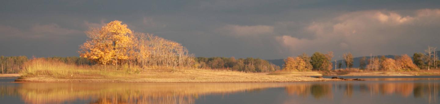
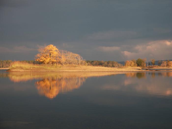
The Ouachita National Forest is located primarily in the Ouachita Mountains of Arkansas and Oklahoma. Outstanding mountain views coupled with picturesque streams, rivers, and lakes provide a unique and highly valued setting for outdoor recreation. The forest offers high quality nature related-sightseeing, scenic driving, hunting, fishing, and dispersed camping. Learn about the areas rich history at wayside exhibits along a scenic drive or experience unique botanical, mineral, and prehistoric resources featured in information and educational programs. An extensive trail system provides for all types of uses including hiking, mountain biking, horseback riding, and off-highway vehicles (OHV) riding. A variety of services can be found at developed campgrounds ranging from rustic tent pads to full-service RV hookups. Enjoy exceptional water-based recreation opportunities including fishing, non-motorized boating, and passive enjoyment of streams, rivers and lakes.
2019 recreation fees and schedule
To view a recreation area on the Recreation Map below:
- Click on the district office Forest Service emblem in your area of interest, or
- Click on "Find An Area" at right.
When viewing an area, use "+" and "-" to size map, and "Map" drop-down menu to choose style of map.
RecAreaDirections
Open with Google Map
Misc
| Stay Limit | |
| Reservable | false |
| Keywords | |
| Map Link | |
| Contact Phone | |
| Contact Email |
Permits info
Facilities
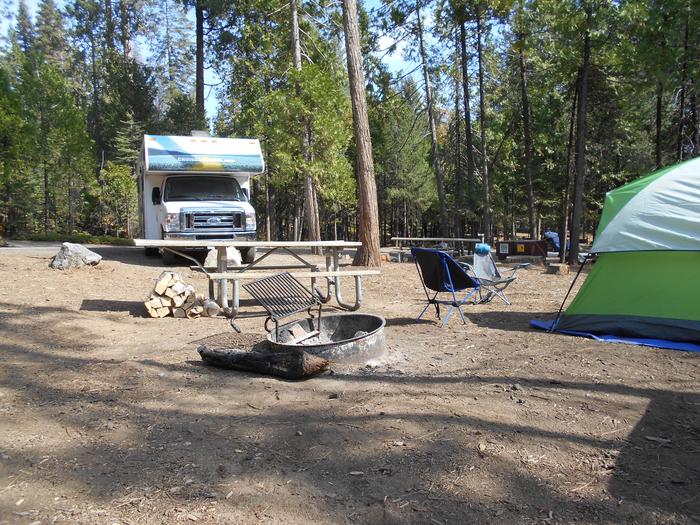
Charlton Recreation Area Campground
List of CampsitesOverview
Charlton Campground is located 17-miles west of Hot Springs National Park along Highway 270-West. This historic campground constructed by the Civilian Conservation Corps (CCC) in the 1930's has been upgraded with modern amenities. Known as one of the coldest swimming sites in the State of Arkansas, the cool water temperatures can be enjoyed through-out the summer months.
Recreation
Charlton Recreation Area offers a developed day use with swimming and picnicking facilities. A large pavilion is located in the day use area. The swimming area is known by area residents as being some of the coldest water through-out the summer months. Walnut Creek, a spring-fed stream provides refreshing water in the swim site. Hiking trails are located in and around the campground. An amphitheater is located in the day use area for group gatherings. Campsites are available from a basic campsite to more developed with additional amenities, to include 30-50 amp electrical service, water connections and some sites offering sewer connections. A dump station is located at the campground. Walnut Creek runs through the campground and access is available for wading and fishing in the creek.
Facilities
A-Loop campsites do not offer electric or water services available at the campsites. Community water spigots are available through-out the loop. B-Loop RV/Tent campsites offer 30-50 amp electrical service and water connections at the sites. C-Loop campsites offer 30-amp electrical service, water connections and some sites offering sewer connections. Warm water showers and flush toilets. Paved roadways and campsites with gravel tent pads for setting up tents. Two Group Use Sites offering areas for large groups to set up tents, tents are only allowed at the Group Use Sites. Swimming and picnicking in the Charlton Day Use Area is included as part of the campsite fees. Two trail systems, one 1 mile interpretative trail system and a connector trail to the Lake Ouachita Vista Trail (LOViT) lead out from the Charlton Day Use Area.
Natural Features
Located in the valley between two tree covered mountains, the campsites through-out the campground are well shaded. The campground constructed along Walnut Creek, a natural spring-fed stream, temperatures are cool, even through the summer months.
Nearby Attractions
Lake Ouachita Vista - Hickory Nut Mountain
Lake Ouachita Vista Trail (LOViT)
Lake Ouachita
Hot Springs National Park
Historic Hot Springs
Quartz Crystal Mines
CEDAR LAKE (OKLAHOMA) Campground
List of CampsitesOverview
Cedar Lake is located in southeast Oklahoma, in the pine and hardwood-forested mountains of the Ouachita National Forest. The campground is situated on the shores of the scenic lake, a popular destination for boating, fishing, horseback riding and hiking.Recreation
The campground is a popular starting point for the Winding Stair Mountain Equestrian Trails, a system of over 70 miles of marked horseback riding trails.
Hiking, swimming, boating and fishing on Cedar Lake are popular activities. A swimming area, boat ramp and fishing piers are available within the recreation area.
A hiking trail traverses around the the perimeter of Cedar Lake offering varied views of the lake and its tributaries.
The Talimena Scenic Byway is located within 10 miles of the campground, offering mountain top views of the valleys around Cedar Lake and historic sites along the way.
The Talihina State Park, the western terminus of the Ouachita National Recreation Trail (OT), is located 21 miles from the Cedar Lake Campground. The OT extends across the Forest for 192 miles, the longest continuous trail system on the Forest.
Kelly Branch Rifle Range is located 10 miles from the recreation area.
Facilities
The campground offers a variety of sites, including equestrian, group and family sites. Shady Lane (SHRV) sites have electric, sewer and water hookups; Sandy Beach sites have electric hookups only; North Shore family sites are primitive without hookups. Most equestrian sites have electric hookups.
Picnic tables, grills, campfire rings and lantern posts are provided, as are flush toilets, warm showers and drinking water. Picnic pavilions are on-site. Horse corrals are located within the equestrian area.
Natural Features
Cedar Lake covers 86 acres and is situated at an elevation of 900 feet. Fall foliage season usually occurs from the last two weeks in October to the first two weeks in November.The Ouachita National Forest covers 1.8 million acres in central Arkansas and southeastern Oklahoma. The forest encompasses 700 miles of trails, 43 vistas, six wilderness areas and the highest elevations between the Blue Ridge Mountains and the Rockies.
Nearby Attractions
Talimena National Scenic Byway is located 10 miles from the campground.
Ouachita National Recreation Trail (OT), western terminus trailhead is located at the Talihina State Park, 21 miles from the campground.
Heavener, Oklahoma, Heavener Runestone Park is located 14 miles from the campground.
Fulton Branch Day Use Facility
River access on Ouachita River.
Caddo/Womble Ranger District Facility
Caddo/Womble Office
1523 Hwy 270E
Mount Ida, AR 71957
(870)867-2101
The Caddo-Womble Ranger District consists of approximately 310,000 acres located in the Ouachita Mountains. The district has very diverse natural resource and recreational programs. Annually, there are timber sales of 18 to 20 MMBF (million board feet), prescribed burns of 25,000 – 30,000 acres, diverse wildlife and fisheries programs, and a unique quartz minerals program. The district office is located in Mount Ida, a small rural community of 900 people surrounded by national forest, Corps of Engineers managed lands, and Lake Ouachita. Lake Ouachita, at 40,000 acres, is one of the largest, cleanest, and most beautiful lakes in the Southern Region of the USDA Forest Service. Hiking, camping, fishing, hunting, canoeing, and water sports such as swimming, scuba diving, and boating attract people from all over the south and midwest to the district. Come visit the Caddo-Womble District to experience our beautiful scenery, vast natural resources, and developed and dispersed recreation programs!
Recreation sites within the Caddo/Womble Ranger District.
Lake Ouachita Vista Overlook Facility
Scenic view of Lake Ouachita. It's also one of the many points of interest along the Lake Ouachita Vista Trail.
Other recreation sites in the Caddo/Womble Ranger District.
Eagle Rock Loop Facility
This trail offers the longest loop trail in Arkansas. A combination of the Little Missouri, the Athens-Big Fork and part of the Viles Branch Horse Trail, this trail travels through the southwestern portion of the Ouachita National Forest. Trail difficulty ranges from easy to most difficult. The trail has nine river/stream crossings and travels over nine mountains. There are also numerous creek crossings.
Recreation Guide - Detailed
Recreation Guide - General
Poteau/Cold Springs Ranger District Facility
Cold Springs Office (479)675-3256
PO Box 417
2190 E Main St
Booneville AR 72927
Poteau Office (479) 637-4174
PO Box 2255
Jct Hwy 71 & 248
Waldron, AR 72958
Poteau-Cold Springs Ranger District is a 334,000 acre unit with a complex mix of natural resource management programs and public use opportunities. Caring for the land is its hallmark, 120,000 acres are dedicated to a unique, nationally recognized project designed to restore the fire-dependent Shortleaf pine/Bluestem grass ecosystem and help restore the endangered red-cockaded woodpecker. The area has also been recognized as Arkansas first “Birding Area”, designated a neo-tropical migratory bird viewing area.
If you enjoy scenic driving check out Forest Road 158, along the crest of Poteau Mountain, just a short distance from the Poteau Mountain Multi Use trail. This route traverses the mountain top and is designated as the Poteau Mountain Rustic Road Auto Tour. This 22 mile auto tour displays spectacular vistas, both pull-in and window vistas while traveling. There are two picnic tables with fire rings designed for day use, although camping is not restricted. Along this route is wildlife viewing opportunities, a historic stage coach crossing, a historic house place with a large natural spring/food cellar, and access to the Poteau Mountain Multi Use Trail.
Access to the tallest waterfall in the Ouachitas is off Poteau Mountain Rustic Road Auto Tour, the trail is approximately 4.6 miles round trip and is considered a moderate hike. Along the route is the rugged and remote 10,884 acre Poteau Mountain Wilderness Area. Located on the north side of the mountain, it includes Slate Falls and Ruggles Cascade and it offers full wildlife hunting and viewing, hiking, and camping opportunities. Vehicles are prohibited.
Approximately 40 miles to the east is the district’s second wilderness area, the 6,000 acre remote and rugged Dry Creek area. Outside the boundary but adjacent to the northwest portion of Dry Creek Wilderness Area is Lake Vista Overlook. Enjoy a panoramic view to the north, east and west overlooking the Petit Jean River Valley and come almost eye-level with the tallest mountain in Arkansas, Mt. Magazine.
More spectacular adventure awaits you back on the south side of the district. Along the crest of Fourche Mountain lies the Ouachita National Recreation Trail. The total trail extends from eastern Oklahoma to almost central Arkansas. Approximately 22 miles of this National Recreation Trail are on the Poteau-Cold Springs District. Use of this trail is designated for foot travel and mountain bike enthusiasts only. Primitive camping is allowed anywhere along the trail, outside of riparian areas along drains where sensitive species of plants could exist.
To add more outdoor recreation opportunities the district supports two pistol, rifle and/or shotgun shooting ranges, Buck Ridge and Brushy Hollow Memorial Shooting Range. Both facilities, as most of our services, are free. Like turkey, deer, bear, squirrel, quail or rabbit hunting? This 334,000 acre unit offers some of the finest. The entire 334,000 acres of the Poteau/Cold Springs are open to the public for free hunting. The only areas where hunting is not allowed are developed recreation areas.
Poteau-Cold Springs Offices located in Booneville (479-675-3233) and Waldron (479-637-4174) are just a phone call or a visit away for more information on district opportunities.
Sugar Creek Hiking Facility
The trail, connecting Knoppers Ford Recreation Area to Jack Creek Recreation area, covers challenging terrain offering excellent views of the Sugar, Middle and Jack Creek drainages and surrounding countryside. A short day hike on this trail allows visitors to view abundant wildlife, interesting geologic formations and pine/hardwood forests.
Sugar Creek Multiuse Facility
The Sugar Creek Multi-Use Trail is a network of looping trails that winds over various types of terrain and through a variety of tree types. Connecting loops offer users an opportunity to explore exciting outdoor opportunities. The Sugar Creek Multi Use Recreation Trail offers motorcycle, 4-wheeler, utility vehicle, horse, bicycle, and foot travel enthusiasts approximately 30 miles of rustic, scenic, historic and picturesque travel ways. The difficulty level ranges from easy to more difficult, with most of the trail being easy to moderate difficulty.
Oklahoma Ranger District Facility
The Oklahoma Ranger District consists of about 363,000 acres located on the west side of the Ouachita Mountains in southeastern Oklahoma. The district is split into three areas: the northern unit is within LeFlore County and has many hiking trails and camp grounds, natural areas and a national recreation area; the central unit contains the large and beautiful Broken Bow Lake that provides thousands of people great fishing and water sports opportunities; the southern unit is more coastal plains with good timber production and a large wildlife area called Red Slough. Annually we have timber sales of about 15 MMBF (million board feet), prescribed burns of 25,000 – 30,000 acres, diverse wildlife and fisheries programs, and many OHV trails/roads. The district has two offices: Hodgen and the main office in Hochatown. Hiking, camping, fishing, hunting, canoeing, and water sports such as swimming, scuba diving, and boating attract people from all over the south and midwest to the district. Come on down and enjoy the beautiful vistas on the Talimena Scenic Drive, fish, camp, hike, drive, or hunt in southeastern Oklahoma.
Boardstand /Military Road Facility
The Old Military Trail starts along Holson Valley Road and connects with the Ouachita National Recreation Trail on the south side of Winding Stair Mountain. These two trails, along with Boardstand Trail, can be combined to form a looped hike of about 23 miles. The trails travel through the western end of Holson Valley and the Indian Nations Scenic and Wildlife Area.
Jessieville Winona Fourche Ranger District Facility
Jessieville/Winona/Fourche Office
8607 N Hwy 7
PO Box 189
Jessieville AR 71949
(501) 984-5313
Jessieville-Winona-Fourche Ranger District covers approximately 406 thousand acres on the north and east end of the Ouachita National Forest. The district is blessed with 11 lakes and numerous creeks and rivers for public fishing and water activities. Recreation opportunities abound. This district has a portion of the Scenic 7 Byway running through it with three Civilian Conservation Corp Camp interpretive sites. It has Richardson Bottoms Wildlife Viewing Area, Winona Scenic Drive, the 9,507 acre Flatside Wilderness area, three walk- in-turkey hunting areas, three designated scenic areas, three developed campgrounds including Lake Sylvia, two public rifle ranges, and 183 miles of trail for hiking, biking, and horseback riding. The Ouachita National Recreation Trail spans 71 miles across the district and has nine trail shelters dispersed along its length for hiker use. The district is also home to Camp Ouachita, a historic Girl Scouts Inc. camp built between 1936 and 1940 by the Works Progress Administration (WPA) and the Civilian Conservation Corp (CCC). The camp is listed on the National Register of Historic Places and is the only surviving WPA and CCC constructed Girl Scouts Inc. camp in the United States.
Mena/Oden Ranger District Facility
Mena/Oden Office
1603 Hwy 71 North
Mena, AR 71953
(479) 394-2382
Mena-Oden Ranger District is a fast paced, complex, multiple use district consisting of approximately 43 permanent employees, several seasonal employees and a large volunteer program We manage approximately 400,000 acres including five recreation areas, two Wilderness areas, two ATV Multi-use Trail Complexes and Historical Tower Sites. Come experience Shady Lake, Bard Springs, Dragover River access, Big Brushy, Shirley Creek Access, Caney Creek Wilderness, Black Fork Mountain Wilderness ,Wolf Pen Gap Trails, Fouche Mountain Trails, Bee Mountain, Rich Mountain and Tall Peak Tower.
The City of Mena sits at the base of Rich Mountain and home of Queen Wilhelmena State Park and Talimena National Scenic Byway. The District has two Visitor Information Stations. One is located at the Mena Ranger Station and another along the Scenic Drive.
Scenic 7 Byway Facility
Distinctive mountain scenery continuously surrounds you on this national forest scenic byway located on the Ouachita and Ozark National Forests. The byway is especially noted for its exquisite fall colors. Special landmarks along the portion of the byway on the Ouachita National Forest include: Nimrod Reservoir, Flatside Wilderness, the Ouachita National Recreation Trail, Jessieville Civilian Conservation Camp, Hollis Civilian Conservation Camp and many stream crossings including the Fourche LaFave River.
Talimena National Scenic Byway Facility
This road offers breathtaking panoramas of the east-west ranges of the Ouachita Mountains. This curving drive winds 54 miles west along the spine of Rich Mountain and Winding Stair Mountain. Between Mena, AR, and Talihina, OK, the drive offers scenic vistas, historical sites, camping, picnicking, hiking, Queen Wilhelmina State Park, Visitor Information Stations, and Robert S. Kerr Memorial Arboretum and Nature Center and Botanical Area.
Red Slough Wildlife Management Area Facility
The Red Slough Wildlife Management Area is a 5,814 acre wetland project designed to restore hydrology and re-establish bottomland hardwoods. It is cooperatively managed by the U.S.D.A. Forest Service, Natural Resources Conservation Service, and Oklahoma Department of Wildlife Conservation. Project goals and objectives are to maximize diversity and offer outstanding recreational opportunities. Red Slough is a very popular recreational destination located in southeastern Oklahoma and is a premier birdwatching and waterfowl hunting area. For photo galleries and links to other information, http://www.fs.usda.gov/detail/ouachita/landmanagement/?cid=STELPRDB5090471.
For information about the history of the Red Slough Wildlife Management Area, recreation opportunities, rules and regulations, and directions to the site, click here.
