
Ozark-St. Francis National Forests
So Much To Do & See
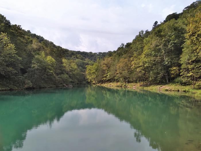
The 1.2-million acre Ozark-St. Francis National Forests offer endless opportunities for adventure. As one of America's most scenic and picturesque areas, the Ozark-St. Francis provides a lot of the "natural" in the Natural State of Arkansas.
A variety of developed and dispersed recreation opportunities await you on the forests. Hiking, horseback riding, mountain biking, floating, kayaking, boating, camping, picnicking, swimming, hunting, fishing, four-wheeler riding and taking pictures are just some of the activities people enjoy while visiting the forests. Each of the recreation areas, trails, wilderness areas or wild and scenic rivers provides unique opportunities to observe nature and enjoy your favorite outdoor activities from cavern tours to hunting black bear and white-tail deer. The Ozark-St. Francis National Forests have something for everyone and are on the way to almost everywhere in Arkansas!
RecAreaDirections
Open with Google Map
Misc
| Stay Limit | |
| Reservable | false |
| Keywords | |
| Map Link | |
| Contact Phone | |
| Contact Email |
Permits info
Facilities
Barkshed Campground Campground
List of CampsitesOverview
This location is available on a first-come, first-served basis only. Visitors are required to physically arrive at the campground to purchase and claim a site. Once on-site, you may be able to pay for your campsite(s) by scanning a QR code using the Recreation.gov mobile app, and the Scan and Pay feature.
If this option is available, you will need to first download the free Recreation.gov mobile app https://www.recreation.gov/mobile-app prior to your arrival as some remote areas have limited or no cellular service.
Gunner Pool Campground Campground
List of CampsitesOverview
This location is available on a first-come, first-served basis only. Visitors are required to physically arrive at the campground to purchase and claim a site. Once on-site, you may be able to pay for your campsite(s) by scanning a QR code using the Recreation.gov mobile app, and the Scan and Pay feature.
If this option is available, you will need to first download the free Recreation.gov mobile app https://www.recreation.gov/mobile-app prior to your arrival as some remote areas have limited or no cellular service.
Horsehead Lake Recreation Area Campground
List of CampsitesOverview
This location is available on a first-come, first-served basis only. Visitors are required to physically arrive at the campground to purchase and claim a site. Once on-site, you may be able to pay for your campsite(s) by scanning a QR code using the Recreation.gov mobile app, and the Scan and Pay feature.
If this option is available, you will need to first download the free Recreation.gov mobile app https://www.recreation.gov/mobile-app prior to your arrival as some remote areas have limited or no cellular service.
Long Pool Recreation Area Campground
List of CampsitesOverview
This location is available on a first-come, first-served basis only. Visitors are required to physically arrive at the campground to purchase and claim a site. Once on-site, you may be able to pay for your campsite(s) by scanning a QR code using the Recreation.gov mobile app, and the Scan and Pay feature.
If this option is available, you will need to first download the free Recreation.gov mobile app https://www.recreation.gov/mobile-app prior to your arrival as some remote areas have limited or no cellular service.
Moccasin Gap Campground
List of CampsitesOverview
This location is available on a first-come, first-served basis only. Visitors are required to physically arrive at the campground to purchase and claim a site. Once on-site, you may be able to pay for your campsite(s) by scanning a QR code using the Recreation.gov mobile app, and the Scan and Pay feature.
If this option is available, you will need to first download the free Recreation.gov mobile app https://www.recreation.gov/mobile-app prior to your arrival as some remote areas have limited or no cellular service.
Ozone Campground Campground
List of CampsitesOverview
This location is available on a first-come, first-served basis only. Visitors are required to physically arrive at the campground to purchase and claim a site. Once on-site, you may be able to pay for your campsite(s) by scanning a QR code using the Recreation.gov mobile app, and the Scan and Pay feature.
If this option is available, you will need to first download the free Recreation.gov mobile app https://www.recreation.gov/mobile-app prior to your arrival as some remote areas have limited or no cellular service.
Redding Campground Campground
List of CampsitesOverview
This location is available on a first-come, first-served basis only. Visitors are required to physically arrive at the campground to purchase and claim a site. Once on-site, you may be able to pay for your campsite(s) by scanning a QR code using the Recreation.gov mobile app, and the Scan and Pay feature.
If this option is available, you will need to first download the free Recreation.gov mobile app https://www.recreation.gov/mobile-app prior to your arrival as some remote areas have limited or no cellular service.
Richland Creek Campground Campground
List of CampsitesOverview
This location is available on a first-come, first-served basis only. Visitors are required to physically arrive at the campground to purchase and claim a site. Once on-site, you may be able to pay for your campsite(s) by scanning a QR code using the Recreation.gov mobile app, and the Scan and Pay feature.
If this option is available, you will need to first download the free Recreation.gov mobile app https://www.recreation.gov/mobile-app prior to your arrival as some remote areas have limited or no cellular service.
Shores Lake Recreation Area Campground
List of CampsitesOverview
This location is available on a first-come, first-served basis only. Visitors are required to physically arrive at the campground to purchase and claim a site. Once on-site, you may be able to pay for your campsite(s) by scanning a QR code using the Recreation.gov mobile app, and the Scan and Pay feature.
If this option is available, you will need to first download the free Recreation.gov mobile app https://www.recreation.gov/mobile-app prior to your arrival as some remote areas have limited or no cellular service.
Sorghum Hollow Campground
List of CampsitesOverview
This location is available on a first-come, first-served basis only. Visitors are required to physically arrive at the campground to purchase and claim a site. Once on-site, you may be able to pay for your campsite(s) by scanning a QR code using the Recreation.gov mobile app, and the Scan and Pay feature.
If this option is available, you will need to first download the free Recreation.gov mobile app https://www.recreation.gov/mobile-app prior to your arrival as some remote areas have limited or no cellular service.
Spring Lake Recreation Area Campground
List of CampsitesOverview
This location is available on a first-come, first-served basis only. Visitors are required to physically arrive at the campground to purchase and claim a site. Once on-site, you may be able to pay for your campsite(s) by scanning a QR code using the Recreation.gov mobile app, and the Scan and Pay feature.
If this option is available, you will need to first download the free Recreation.gov mobile app https://www.recreation.gov/mobile-app prior to your arrival as some remote areas have limited or no cellular service.
Wolf Pen Campground Campground
List of CampsitesOverview
This location is available on a first-come, first-served basis only. Visitors are required to physically arrive at the campground to purchase and claim a site. Once on-site, you may be able to pay for your campsite(s) by scanning a QR code using the Recreation.gov mobile app, and the Scan and Pay feature.
If this option is available, you will need to first download the free Recreation.gov mobile app https://www.recreation.gov/mobile-app prior to your arrival as some remote areas have limited or no cellular service.
BLANCHARD SPRINGS CAVERNS Ticket Facility
Overview:
Blanchard Springs Caverns is one of the most spectacular and carefully developed caves found anywhere in the world. It is located in the Ozark National Forest and is believed to have been formed, and continually changed, by an ongoing mountain spring that pours into a glassy-surfaced trout pond below the cave, called Mirror Lake.Before entering the cavern, visitors will have an opportunity to view a short movie, introducing the wonders of the underground world they are about to discover. A variety of tours throughout the year provide visitors with different views of the cavern, as well as varying difficulty levels.
The active cave, with its glistening formations, stalactites, stalagmites and flowstones is constantly changing, providing return visitors something new to see each time. Beautifully lighted rooms, that accentuate the cave's features, are equipped with handrails and paved trails for comfortable walking. An undeveloped section of the cavern allows visitors an opportunity to climb over rocks, crawl through tight spaces and slide on red clay mudslides.
Prices to view the cavern vary, depending on age and time of year. Group rates are available. The site's Visitor Center is equipped with a gift shop, exhibit hall, displays and accessible toilets, as well as information about the surrounding area.
Summary of Fees - BLANCHARD SPRINGS CAVERNS
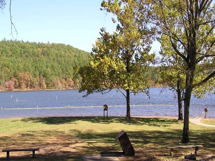
COVE LAKE RECREATION AREA Campground
List of CampsitesOverview
The Cove Lake Recreation Area is a perfect summer getaway and an ideal place to camp, picnic or recreate. It envelops the shores of a 160-acre mountain lake near the 2,700-foot-tall Mount Magazine, the highest point in the state of Arkansas.Recreation
Popular activities include swimming, fishing, hiking, water skiing and scenic drives. A boat ramp is available and an on-site concessionaire provides boat rentals and other equipment available for purchase.The lake is home to catfish, large mouth bass, bluegill, sunfish, crappie and perch. It is stocked every other year, although a small amount of catfish are stocked annually and just prior to a yearly kids' fishing derby hosted at the lake.
Facilities
The recreation area provides picnic areas, campsites and a group shelter, as well as multiple activities, including miniature golf, canoe and paddleboat rentals. The campground offers multiple single-family sites for tent or RV camping.Each site is equipped with tables and campfire rings with grills. Accessible flush toilets, hot showers and drinking water are also provided. Multiple picnic areas are available on the lake shore, including a picnic shelter that has electricity.
Natural Features
The recreation area is situated in a mixed forest of mature trees and is located in the Arkansas River Valley in the Ozark National Forest.Nearby Attractions
The recreation area is about 15 miles south of the town of Paris, in Logan County, Arkansas. A scenic route to the top of Mount Magazine is a beautiful 10 mile drive north from Havana, Arkansas.LAKE WEDINGTON Campground
List of CampsitesOverview
Lake Wedington beckons visitors of many types, those who come to relax and fish all day, those who come to speed along on bike paths or cruise on a boat, and those who want to stay in a cabin as a lakeside home-away-from-home. The recreation area also offers convenient access, as it is located just 13 miles west of Fayetteville, and 13 miles east of Siloam Springs.
The facility offers several rental cabins, campsites and picnic sites alongside its the lake. Each offers access to a variety of outdoor recreation opportunities. The area can be accessed by vehicle and a parking space should be available. Guests are responsible for their own travel arrangements and safety, and must bring several of their own amenities.
Recreation
Visitors can enjoy a variety of recreational activities at Lake Wedington. Those who enjoy water activities can go boating (with a motor that is 10hp or less), kayaking and canoeing, as well as fishing on the lake. Anglers can seek out Bluegill, Largemouth and Spotted Bass, Bream, and Channel Catfish, and several other species. Anglers who like a challenge can attempt to fish for one of the few large Grass Carp that occupy the lake. A former world-record Grass Carp was caught out of Lake Wedington, weighing a total of 80 pounds.
Lake Wedington also has a dedicated area for those who want to go swimming, picnic, play a round of Volleyball or Horseshoes, and a variety of playground equipment. Surrounding the park, you’ll find trails that accommodate hikers and mountain bikers. The Lakeshore Hiking Trail circles a large portion of the lake. The North Twin hiking and mountain biking trial extends for sixteen miles from the facility.
Hunting is not permitted within the recreation grounds of Lake Wedington, but there are sites surrounding the recreation area that are open to seasonal hunting. Please contact staff or Arkansas Game and Fish for further information on hunting regulations within this unit.
Facilities
In the 1930s, the lake and recreation area were built under the guidance of the Soil Conservation Service. The Forest Service acquired the land in 1954, and with the help of volunteer groups, restored the buildings. The location is now listed on the National Register of Historic Places. Guests who rent one of the six cabins will get the opportunity to stay in a historic structure from the 1930s, while still enjoying the luxuries of a cozy bed and a coffee maker.
Main Area
In the main recreation area of Lake Wedington, visitors will find the historical cabins, bathhouse, lodge, and boathouse. The main area also contains additional bathrooms, drinking fountains, group pavilion, picnic ground, the gatehouse, a group campsite, and the main park office. The lodge, cabins, group pavilion, and group campsite must be reserved, please contact park staff for further details on reservations.
The picnic pavilion and lodge are available for day-use only. The picnic pavilion can accommodate up to 75 guests and the lodge can hold up to 200 people.
The six historic cabins are equipped with electricity, including heating and air conditioning. A kitchen area in each of the buildings is equipped with a stove, refrigerator, coffee maker, toaster, cooking pots and pans and basic tableware. Linens, towels and bedding are not provided. Guests should pack food, towels, blankets and/or sleeping bags, pillows, and other basic overnight supplies.
Campgrounds
In the campgrounds area of Lake Wedington, visitors will find the boat launch ramp and just beyond that, 18 standard campsites (no hookups available), a dump station, and two smaller bathhouses to accommodate the campers in the campgrounds. Each campsite offers a parking space, tent pad, picnic table, designated fire pit, and a charcoal grill.
Some campsites can accommodate camping trailers and smaller RVs, but no hookups are available (each site will list what it can accommodate on the reservation page). If the site isn’t reserved already, they are open to first-come, first-serve, but we do encourage reserving them in advance. Please contact staff or call the recreation.gov help line for reservation assistance, if needed.
Natural Features
Visitors will find a variety of wildlife, trees, ferns, and wildflowers surrounding the 102-acre Lake. Wildlife in the area includes rabbits, deer, songbirds, and wild turkeys as well as an array of migratory waterfowl. In winter, eagles may be sighted flying around the park.
Fall leaves put on quite a show, often attracting photographers. Sloping hills in the area offer great vantage points to take photos of the lake, especially from the Gazebo located just off of Lakeshore Trail. When the lake is high, hikers are presented with a cascading waterfall that can also be found when walking along the Lakeshore Trail. There are many natural features that can be spotted throughout the area to those who keep a keen eye out for them.
Nearby Attractions
With Fayetteville approximately 15 miles East, Siloam Springs 14 miles West, and Lincoln/Prairie Grove within 15 miles South of Lake Wedington, there are many attractions to choose from. A variety of restaurants and food venues can be found in and around all cities and towns.
In Fayetteville you will find a large variety of event venues, museums, shops, golf clubs, and theaters.
In Siloam Springs you can find a variety of shops, group activity venues, and the Kayak Park.
Around Lincoln you will find a few shops, restaurants, and event/activity venues.
In Prairie Grove you will also find a variety of shops, restaurants, and parks.
There are many attractions available at, and surrounding, Lake Wedington. So, guests will find a variety of options available for them to choose from in addition to enjoying the Lake Wedington Recreation Area.
Bear Creek Lake Recreation Area Facility
The 625-acre Bear Creek Lake Recreation Area has 30 miles of shore line and offers the following recreational opportunities: camping, picnicking, swimming, canoeing, fishing and hiking. Sitting atop Crowley’s Ridge, the recreation area offers three campgrounds, two picnic areas, a mile-long nature trail, a swim beach and a handicap-accessible fishing pier which all provide visitors a variety of recreational experiences. Bear Creek Nature Trail provides a one-mile loop winding through a forested area. There are excellent scenic views of the lake shoreline, including Beech Point, and interpretive posts that highlight ecology in action. Trophy Largemouth Bass, Red-eyed Bream and Channel Catfish are just a few of the many species of fish that you’ll find in the lakes and streams in the area.
Fish Your National Forests: This site can be accessed by Passenger Car; Fish available include: Bass, Panfish; Types of fishing available include: Shore, Motorized boat, Float tube, Fly, Spin, Bait; ADA Accessible fishing access with fishing pier and boat launch
The Bear Creek Lake Recreation Area is managed by the Mississippi River State Park. Please call the Mississippi River State Park - Marianna Office for any questions at 870-295-4040.
Gunner Pool Recreation Area Facility
The Gunner Pool Recreation Area offers a campground stretching along the scenic North Sylamore Creek. Campsites are shady and private, but have no electrical or water hook-ups. This recreation area is located within the Sylamore Wildlife Management Area. Hunting is permitted anywhere except within developed recreation areas or where otherwise posted. This management area provides hunting for whitetail deer, wild turkey, black bear, squirrel and other game in season. Visitors can access the Sylamore Hiking Trail via a trailhead located within the Gunner Pool campground. Blanchard Springs Caverns is located just minutes away from this recreation area. The White and Buffalo Rivers border the east and west sides of the district, where visitors can enjoy float fishing and canoeing. Camping- 27 campsites with grills, tables, lantern poles and tent pads. Access is by a steep, winding, dirt road, not recommended for large recreation vehicles.
Gunner Pool Recreation Area Guide
Campground and Day-Use Area Rules
Huckleberry Walk-in Turkey Hunting Area Facility
The Huckleberry Mountain Walk-In Turkey Hunting Area, located in Logan and Yell Counties, is 8,069 acres in size and located south of Sorghum Hollow Road, east of Eickleberry Road, north and west of Spring Lake Road on the Mt. Magazine Ranger District of the Ozark-St.Francis National Forests.
Richland Creek Wilderness Facility
The Richland Creek Wilderness was created by the 1984 Arkansas Wilderness Act and contains 11,801 acres in the middle of the Boston Mountains. One of three wildernesses on the Buffalo Ranger District, it takes its name from the main creek running through the area with the rich, fertile soil along the lower creek portion near the Buffalo River. An unusual feature of the Ozark Mountains is that the “mountains” are actually plateaus, uplifted as a unit with few folds or faults. The ruggedness of these mountains is due to erosion of the plateaus caused by swift rivers flowing between them. Topography within 1/4 mile on either side of Richland and Long Devil’s Fork Creeks is quite rugged and scenic. Rock bluffs over 100 feet high and extending over a mile along each side of Richland Creek graphically reveal the earth’s development. The forest cover is mostly second and third growth oak-hickory. Some scattered stands of shortleaf pine in old fields exist from when the Forest Service purchased the land in the 1930s and 1940s. There are no developed trails located in the wilderness. There is a system of old logging roads that run throughout the area and receive sporadic use. Kayakers float Richland Creek after rains have raised the creek water level. The wilderness area is known for its crystal clear creeks and waterfalls. Remember to take drinking water or a filtration device with you for your safety.
Wolf Pen Recreation Area Facility
This campground, located next to the Mulberry River, offers scenic rock bluffs in the northwestern portion of the state. Activities include canoeing on the Mulberry River (very popular with the canoeists) within view of the scenic rock bluffs, fishing, hiking and river access. Camping consists of 6 primitive units, available space for small camping trailers, and the picnicking area is designed for 5 family units. The area is also equipped with vault toilets but there is no drinking water. Good fishing and hunting is available nearby when in season.
Campground and Day-Use Area Rules
Ozark National Forest Scenic Byway Facility
SCENIC 7 BYWAY includes 60.6 miles of Highway 7 that connects Louisiana to Missouri through Arkansas. It crosses the Piedmont area of Arkansas through the Ouachita Mountains, then drops into the Arkansas River Valley near Russellville before once more climbing into the Ozark Highlands. Scenic 7 takes the traveler through two national forests and a national park, over a national river, and by several state parks.
Kapark Trailhead Facility
Provides access to the Upper Buffalo Wilderness.
Driving directions: From Fallsville, take AR Hwy 21 east for about 1.25 miles to Forest Road 1463; turn north on Forest Service Rd 1463 and travel 6 miles, crossing the Buffalo River, (once across the River, the road changes designation to FS Rd 1410). Just before the river crossing is a small parking area and dispersed camping location known as Dixon Ford.
Dahl Memorial Trailhead Facility
Provides access to Upper Buffalo Wilderness
Driving Directions: From Fallsville, take AR Hwy 21 east for 1.25 miles to FS Rd 1463. Turn north on FS Rd 1463. Go 2 miles to FS Rd 92285A. Turn right and follow FS Rd 92285A for 0.10 mile to the small parking area.
Dixon Ridge Trailhead Facility
Provides access to the Upper Buffalo Wilderness
Whitaker Point Trailhead Facility
Provides access to the Upper Buffalo Wilderness
Zing Trailhead Facility
The Zing Trailhead provides access to Brock Creek Multi-Use Trail System.
Boen Gulf Trailhead Facility
Provides access to the Upper Buffalo Wilderness.
Driving directions: From Deer, take AR Hwy 16 west to the junction of AR Hwy 21. Take AR Hwy 21 north for 2 miles to FS Rd 1462 (Newton County Rd 6). Turn east on FS Rd 1462. Go 0.25 miles to the parking area located on the north side of the road, off a short spur.
BLANCHARD SPRINGS RECREATION AREA Campground
List of CampsitesOverview
Blanchard Springs Recreation Area is located in the scenic Ozark National Forest. The Ozark Mountains are known for beautiful "rolling" hills, hidden caverns, waterfalls and clear flowing streams. Examples of early Ozark culture and music can be found throughout the region. Blanchard recreation area is a great starting point for an Ozark adventure.Recreation
Trout fishing is available on nearby Mirror Lake.Other popular activities in the Blanchard area include mountain biking, hiking and swimming.
Facilities
The campgrounds offer a variety of campsites to accommodate all types of visitors, including group and single campsites. All sites are equipped with tables, grills and campfire rings. Individual sites are on a first come, first served basis. The individual sites are open except when there is high water. To check campground status, call 870 757 2211. The picnic shelters have grills and ample picnic tables for groups. Flush toilets and drinking water are provided.Natural Features
The facilities are near picturesque rock bluffs and crystal clear streams. Sites are well shaded by stately yellow pine trees.Nearby Attractions
Blanchard Springs Caverns offers tours, exhibits and family activities. North Sylamore hiking trail follows the scenic Sylamore creek for 25 miles and connects to the Ozark Highland trail. Mountain biking is available on 50 miles of the Syllamo Mountain Bike Trail.Blanchard Springs Campgrounds Campground
List of CampsitesSeventeen individual campsites and two group sites available. Water available. Sewage dump station available. Sites suitable for smaller RV's and tents. No electricity or other hook ups.
Blanchard Springs Recreation Area Guide
Campground and Day-Use Area Rules
Blanchard Springs Recreation Area Guide - Spanish
WHITE ROCK MOUNTAIN RECREATION AREA Campground
List of CampsitesOverview
Experience nature and adventure at historic White Rock Mountain! This National Forest Recreation Area features three unique and rustic natural stone cabins and a large natural stone lodge built in the 1930s by the Civilian Conservation Corps (CCC). Each features a stone fireplace new, antique, and original wood furniture handcrafted by the CCC. Wind, rain and natural elements had caused the deterioration of the buildings over the years. In 1987 a volunteer group, Friends of White Rock, began a project to renovate the historic structures. With a lot of commitment and hard work, the lodge and cabins were restored to their original state in 1991. White Rock Mountain also offers nine primitive family camping sites. These easily accessible shaded campsites include tents pads, fire rings, grills, picnic tables and access to restrooms and water. Small RVs or pop-up campers can be accommodated at a few sites.Recreation
White Rock Mountain is the hub of several national forest hiking trail systems including the easy 2 mile trail around the mountain top rim, the 17 mile Shores Lake/White Rock loop trail, and the renowned 170 mile Ozark Highlands Trail. Other recreational activities include swimming, boating (non-motorized) or fishing at Shores Lake Recreation Area; swimming, floating or fishing the National Scenic Mulberry River; Mill Creek and other National Forest ATV trails; mountain biking, hunting and more.Facilities
The grounds at White Rock Mountain are open year-round. There is a gravel parking area, clean vault toilets, and eight family picnic units with grills and tables. The facility features four CCC crafted shelters along the White Rock Rim Trail that offer spectacular views. Overnight parking for the Ozark Highlands Trail access is available onsite.
The lodge and three cabins are available for rent at White Rock Mountain. The lodge and cabins have electricity and running water. All units are equipped with bathrooms and a full kitchen. Each kitchen includes a stove, refrigerator, microwave, coffee pot, crock pot, dishes, cooking utensils, and cooking pots and pans. The furnishings feature new, antique, and original CCC furnishings. Each building has a large private patio with a charcoal grill and fire pit. There is no air conditioning; the stone lodge and cabins stay cool in the summer months. Heat is provided by wood burning stoves during the winter and firewood is provided. Linens, towels and bedding are not provided. Guests should pack food, towels, pillows, blankets or sleeping bags, and all other necessary overnight supplies.
There are nine family campsites at White Rock. The sites do not have electric or water hookups. Sites are equipped with tent pads, picnic tables, fire rings, grills and lantern poles. There is access to drinking water and an accessible vault toilet within close proximity to all sites. Firewood is available for purchase onsite.
Visit the onsite General Store for information, souvenirs, snacks, pizza, beverages, maps, firewood and other backcountry supplies.
Natural Features
White Rock Mountain is 2,309 feet above sea level and received its name from the appearance of the lichen on the sheer bluffs that appear white from a distance. Guests at White Rock can enjoy incredible scenic views from the lodge, cabins, campground and bluffs. The forest is home to a large variety of wildlife including deer, bear, bald eagles, turkey and more. In the fall season White Rock Mountain offers unrivaled opportunities for taking in the bright red, orange and yellow autumn foliage that sweeps across the Ozark National Forest. The forest around White Rock is also a waterfall hunter's paradise featuring several great falls located in the surrounding area.Nearby Attractions
Ozark Highlands Trail, Shores Lake Recreation Area, National Scenic Mulberry River, Mill Creek and other ATV Trails, Waterfalls, Scenic Drives, Mountain Biking, Wineries (Altus, AR) and more.Charges & Cancellations
Rules & Reservation Policies As you make travel plans that include reservations on Recreation.gov, there are standard policies that apply to most locations of which you should be aware. Do keep in mind, however, that there are many exceptions, so it is best to review reservation information listed on individual facility pages for those policies and procedures that pertain to your specific locations. Booking Window For most locations, you can reserve six months in advance of your stay for individual sites and 12 months in advance for group sites. There are some exceptions, so it is best to check with each facility. Change and Cancellation Policies and Fees Overnight and Day Use Facilities: To ensure fairness, reservation arrival or departure dates may not be changed beyond the booking window until 18 days after booking the reservation. Camping / Day Use: A $10.00 service fee will apply if you change or cancel your reservation (including campsites, cabins, lookouts, group facilities, etc.). The $10.00 service fee will be deducted from the refund amount. You can cancel or change reservations through Recreation.gov or by calling 1-877-444-6777. Late Cancellations Overnight and Day Use Facilities: Late cancellations are those cancelled between 12:01 a.m. (Eastern) on the day before arrival and check out time on the day after arrival. Individual Campsites: If a customer cancels a reservation the day before or on the day of arrival they will be charged a $10.00 service fee and will also forfeit the first night's use fee (not to exceed the total paid for the original reservation). Cancellations for a single night's reservation will forfeit the entire use fee but no cancellation fee will apply. Cabins / Lookouts: Customers will be charged a $10.00 cancellation fee and forfeit the first night's use fee if a cabin or lookout reservation is cancelled within 14 days of the scheduled arrival date. Cancellations for a single night's use will not be assessed a service fee. Group Facility: If a customer cancels a group overnight facility reservation within 14 days of the scheduled arrival date they will be charged the $10.00 service fee and forfeit the first night's use fee. Cancellations for a single night's use will not be assessed a service fee. Group Day Use Area: If a customer cancels a group day use facility reservation within 14 days of the scheduled arrival date, they will forfeit the total day use fee with no service fee charge. No-Shows Camping / Day Use: A camping no-show customer is one who does not arrive at a campground and does not cancel the reservation by check-out time on the day after the scheduled arrival date. Reserved campsites and group overnight facilities will be held until check-out time on the day following your scheduled arrival. Group day-use facilities will be held until check-in time on your scheduled arrival date. If a customer does not arrive at the campground or group facility by check-out time the day after arrival or does not cancel the reservation by the times listed under "Late Cancellations" above, the customer may be assessed a $20.00 service fee and forfeit use fees.Sams Throne Recreation Area Facility
Primarily well known as a rock climbing site, Sam's Throne, near Mt. Judea, is also a popular hiking, camping and photography destination. Located up on Judea Mountain and overlooking the Big Creek valley below, the scenic views will show you why this is such a popular place.
Campground and Day-Use Area Rules
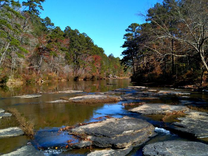
Big Piney Creek Facility
The Big Piney Creek is designated as a National Wild & Scenic River that begins near the community of Fallsville and flows east and south for 57 miles to its junction with the Arkansas River. The river's outstandingly remarkable values include scenery, recreation, fish, botany and geology.
The distinctive scenery of Big Piney Creek is characterized by its sandstone bluffs, waterfalls, still pools and stands of oak, hickory and pine. Principal recreation activities in the corridor include canoeing, camping, swimming and fishing. The river is very popular for canoeing, with Class I to III rapids. It is considered by the Arkansas Game and Fish Commission to be an outstanding sportfishing river, with smallmouth bass and spotted bass the most sought-after species.
Big Piney supports plant species considered by the Arkansas Heritage Commission to be sensitive. One species, Alabama snow-wreath, is currently under study for listing as a federal threatened and endangered species and is already listed as threatened by the state of Arkansas. The corridor also includes the Waldo Mountain-Wainscott Bottoms Special Interest Area, which contains diverse plant communities and plant species.
The Mississippian and lowermost Pennsylvanian rock exposed near the town of Limestone are very important to understanding the history of the southern margin of the Ozark platform. The youngest Mississippian-age rocks in North America, as well as the southernmost exposure of Morrowan-type rocks, are located in this area. These exposures create a structural window important in developing an understanding of the upper Mississippian and the basal Morrowan sequence. Many of these features are exposed along Big Piney and are of unique scenic and geologic value.
Float map of the Big Piney Creek
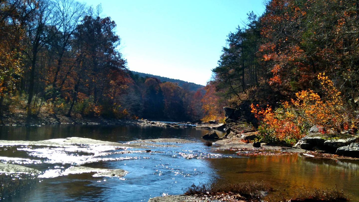
Mulberry River Facility
The Mulberry River is located in Newton, Johnson and Franklin Counties, Arkansas and is designated as a National Wild and Scenic River. The river has also been recognized by Arkansas Game and Fish Commission as one of the premier smallmouth and spotted bass fisheries in Arkansas. The Mulberry is also popular for canoeing, camping and swimming, offering Class I to II rapids.
Visitors to the Mulberry can expect basic Ozark Mountain scenery--narrow canyons, tree-lined bluffs, and dense woods. A good assortment of wildlife is found in the immediate area, including one of the state's largest concentrations of black bears. The stream itself is clear, cool, and challenging.
Traditional floating months are late fall to June, but conditions can vary according to local rainfall. Readings between 2.0 and 4.0 are ideal, while 4.5 and beyond are considered dangerous. Canoeists should also make a point of checking into local weather forecasts. A heavy rain can quickly transform the Mulberry into a rampaging torrent. Because of the chance for these sudden rises, visitors are advised that camping is recommended to be at least 100 feet from the river.
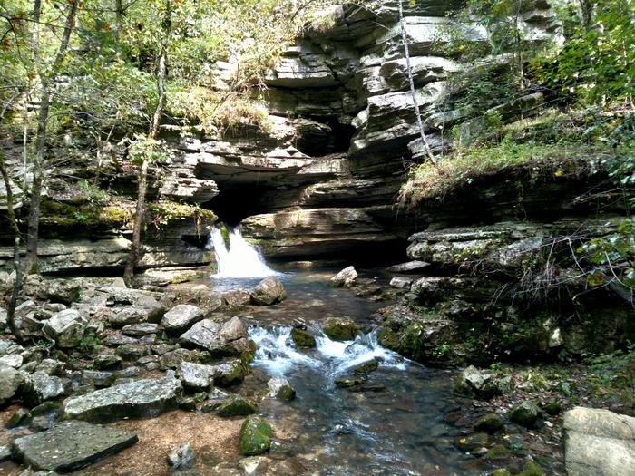
Blanchard Springs Caverns Facility
Blanchard Springs Caverns is one of the most spectacular and carefully developed caves found anywhere. Visitors enter a "living" cave where glistening formations like stalactites, stalagmites, columns, and flowstones are still changing. These crystalline formations are the result of minerals deposited by dripping water. Forest Service interpreters guide all tours. For more information about this natural wonder, check out the Blanchard Springs Caverns website.
