
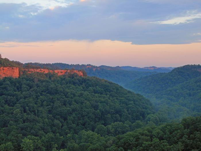
Daniel Boone National Forest
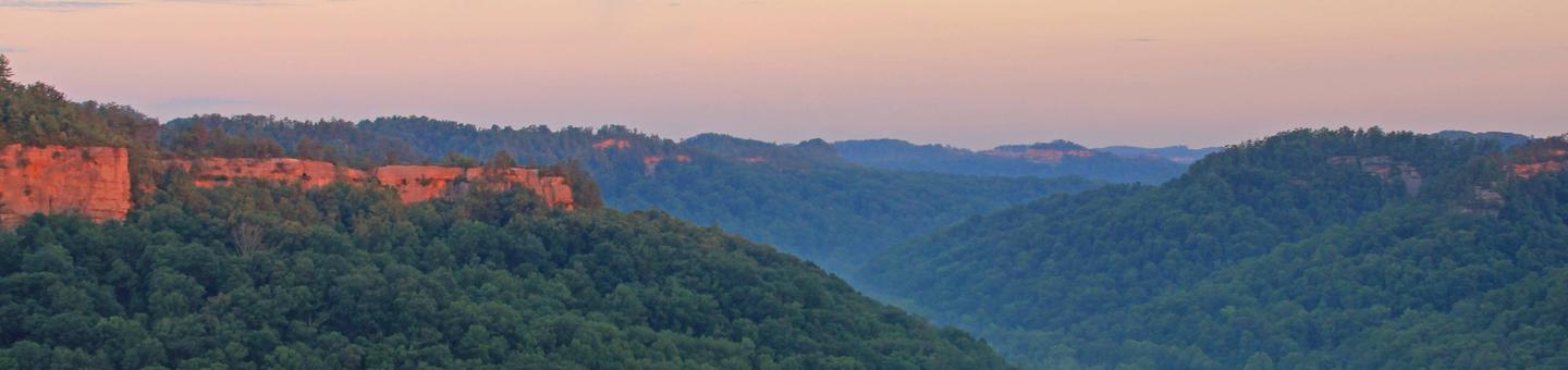
The Daniel Boone National Forest offers an abundance of outdoor recreation opportunities. Camping, hiking and fishing are just a few of the attractions that draw more than one million visitors to the forest each year.
Fees are required at some areas, such as boat ramps and campgrounds. However, most recreation opportunities are free for your use and enjoyment. Commercial outfitters, guides and groups of 75 people or more must obtain a Special Use Permit prior to hosting an event.
RecAreaDirections
n/a
Open with Google MapMisc
| Stay Limit | |
| Reservable | false |
| Keywords | |
| Map Link | |
| Contact Phone | |
| Contact Email |
Permits info
Facilities
CRAIGS CREEK GROUP AREA Campground
List of CampsitesOverview
Craigs Creek Group Area is perched near Laurel River Lake in the Daniel Boone National Forest. Here, group campers find hours of fun playing on the sports field, firing up the grills and exploring the beautiful lake.Daniel Boone National Forest protects 23 species listed as federally threatened or endangered. Species range from the magnificent bald eagle to the small Indiana bat and the Cumberland Sandwort.
Recreation
The hiking and biking trail at Craig's Creek is an easy, half-mile path that features several views of the lake.Picnicking, boating and fishing are popular pastimes for visitors. Fish species include crappie, catfish, small and largemouth bass and rainbow trout.
A spacious sports field with a volleyball net and horseshoe pits lies near the picnic shelter.
Facilities
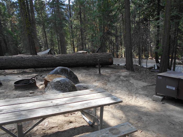
Group sites are for tent camping only and do not have electricity. The day-use picnic shelter fits 60 guests, and the group campsites fit up to 30 and 60 guests, depending on the location.Each group camp area comes with a campfire circle, large grill, picnic tables and a lantern pole. Modern vault toilets and a shower house are available.
Natural Features
The campground sits on Craig's Creek, which flows into an arm of Laurel River Lake across from Holly Bay Campground. The group site lies in a somewhat open space surrounded by woods.Set in the Appalachian foothills, plenty of hills and valleys create a beautiful backdrop for the lake area.
GROVE Campground
List of CampsitesOverview
Grove Campground is perched on a forested ridge above Laurel River Lake in Kentucky's Daniel Boone National Forest. The lake, fed by the Laurel River, is considered one of the most scenic lakes in the state. Boating, fishing, hiking and biking are greatly enjoyed by campers.Recreation
Hikers, horseback riders and mountain bikers can trek more than 600 miles of road and trail in Daniel Boone National Forest. Duff Branch, Oak Branch, Fishing Point and Singing Hills Trails can all be accessed in the immediate area.Anglers find prized catches of walleye, crappie, brown trout and rainbow trout at Laurel River Lake. Boating and swimming are also popular activities. A boat ramp is located nearby at Grove Marina.
Facilities
The campground offers single and double family campsites, which have 20 and 30-amp electric hookups. Each site is equipped with a picnic table and campfire ring.Flush toilets, drinking water and showers are provided. Ice and firewood are sold on-site. Limited groceries can be found at Grove Marina.
Natural Features
The campground overlooks the lake and is less than a mile from the shoreline. Laurel River Lake boasts 5,600 acres of deep, clear water and 192 miles of cliff-lined shores. Bountiful hills and valleys create a beautiful backdrop for the lake area.The forest was named after Daniel Boone, a famous frontiersman and explorer who settled in Kentucky in the late 18th century.
HOLLY BAY Campground
List of CampsitesOverview
Holly Bay, located two miles north of the Laurel River Dam, sits on the west side of Laurel River Lake. Visitors enjoy the campground for its proximity to the water and beautifully forested location. Plus, Holly Bay is ideal for activities like power boating, canoeing and fishing.The forest was named after Daniel Boone, a famous frontiersman and explorer who settled in Kentucky in the late 18th century.
Recreation
Boating and water skiing are a big hit. A boat ramp and fish cleaning station are located a short distance from the campground.Hikers take pleasure in the 4.2-mile Sheltowee Trace Trail that leads from the campground to the dam.
Facilities
The campground offers single and double-family campsites, some of which have 20, 30 or 50-amp electric hookups. Some campsites overlook the lake.
Flush toilets (one is accessible), two shower houses, drinking water and a dump station are provided. Firewood and ice are available for purchase. Educational programs are held during the summer.
Natural Features
Most campsites are surrounded by a mixture of hardwood trees that provide picture-perfect colors in autumn. Laurel River Lake spans 5,600 acres of deep, clear water and 192 miles of cliff-lined shore. Bountiful hills from the Appalachian foothills create a backdrop for the lake area.Nearby Attractions
Head to the Cumberland Falls Trail that begins at Cumberland Falls and ends at the mouth of the Laurel River. This trail is a 30-45 minute drive from the campground.ZILPO - DANIEL BOONE NAT. FOR. Campground
List of CampsitesOverview
Zilpo, a large, fun-filled campground on Cave Run Lake, is a prime destination for families. The scenic campground offers a cabin rental, tent camping, RV sites with electric hookups and a selection of lakefront sites.Views of the lake are enjoyed by those who relax on the sandy beach. Tater Knob, a fire tower open to the public, is nearby, offering outstanding views of the area.
Recreation
Water skiing and swimming are wonderful ways to enjoy the lake. Muskie, large and smallmouth bass, bluegill, crappie and catfish attract avid anglers. Hikers are fans of the Zilpo Mountain Loop Trail that extends for 2.25 miles, connecting to a network of other trails around the lake.Nature programs are regularly scheduled during peak season and wildlife watching is rewarding.
Facilities
Electric hookups are provided at some campsites. Drinking water is located centrally within the loops. Flush toilets and showers are spread throughout the campground as well. Each site has a picnic table and campfire ring. A dump station and concrete boat ramp are also included.Each of the 12 cabins can accommodate up to six guests. They each have a table, two chairs and a sleeping area with two sets of bunk beds (4 beds). A picnic table, lantern post and campfire ring are provided outside. Pets may reside only in cabins 41,120,121 and 123. Cabins 109, 123 and 136 have ramps that can accommodate wheel chairs.
A campground store with ice, firewood, camping gear and food is on-site. Roads are paved and level tent pads are gravel.
Natural Features
Zilpo sits on a peninsula in the middle portion of Cave Run Lake at an elevation of 800 feet. The lake spans 8,270 acres with soft, sandy beaches. The campground is shaded by a stand of mixed hardwoods, and campsites have good privacy.Nearby Attractions
The nearest community is 12 miles away.TWIN KNOBS CAMPGROUND Campground
List of CampsitesOverview
Nestled on the shores of Cave Run Lake, this camp is part of the larger Twin Knobs Recreation Area. There are more than 200 sites spread out over 10 loops under a dense forest of mixed conifer and deciduous trees.The recreation area includes two reservable group picnic areas. Group camping is also available.
Recreation
Summer amphitheater programs and scheduled campground activities provide family fun and entertainment. The campground also has volleyball courts, basketball hoops and horseshoe pits.There is a boat ramp and beach. Popular lake activities include fishing, swimming, motor boating, windsurfing, sailing and water skiing.
Scenic foot trails include the 2.5-mile Twin Knobs Shoreline Trail and the 1.5-mile Knob Overlook Trail.
Facilities
There is a variety of different camp sites that include paved spurs that can accommodate any size RV, picnic tables, fire rings and grills. Some sites have electric hookups.Facilities include bathhouses with showers, drinking water and flush toilets. The bathhouses and some picnic areas are accessible.
Natural Features
The Daniel Boone National Forest embraces some of the most rugged terrain west of the Appalachian Mountains. The forest lies within the Cumberland Plateau, where steep forested slopes, sandstone cliffs and narrow ravines characterize the land in this region.Cave Run Lake is in the Cumberland District in the northernmost part of the forest. The lake is surrounded by the rolling hills of northeastern Kentucky.
Nearby Attractions
The Morehead Office Visitor Center offers information about the Daniel Boone National Forest in addition to interpretive exhibits. A popular attraction within the Daniel Boone National Forest is the Red River Gorge Geological Area, which features more than 100 natural sandstone arches.Redbird Wildlife Management Area Facility
Redbird Wildlife Management Area was created through a cooperative effort between the Commonwealth of Kentucky and the USDA Forest Service.
Make this page look nicer by submitting photos of your visit to the Redbird Wildlife Management Area. Learn more...
View Map and Learn More about this Wildlife Management Area.
Mill Creek Wildlife Management Area Facility

Mill Creek Wildlife Management Area is cooperatively managed with the Kentucky Department of Fish and Wildlife Resources to promote and sustain native wildlife populations. The terrain is mostly hilly with steep slopes and long, narrow ridges. Some flat areas occur in the bottoms and on the tops of ridges. The area is mostly wooded with nearly 30 acres maintained as wildlife openings. The area has no developed facilities.
Make this page look nicer by submitting photos of your visit to Mill Creek Wildlife Management Area. Learn more...
Mill Creek is located in Jackson County, Kentucky, just two miles south of McKee on the London Ranger District. Call 606-864-4163 for more information.
Public Hunting Area users must abide by the Kentucky hunting, trapping, and fishing regulations. Persons using Public Hunting Areas should become familiar with these regulations. Kentucky Department of Fish & Wildlife Resources provides these regulations at fw.ky.gov or by calling 1-800-858-1549.
Rock Creek Facility
Rock Creek is a beautiful stream, with magnificent boulders, riffles, glides, and pools. Flowing through southeastern Kentucky on Stearns Ranger District, it is both a Blue Ribbon trout fishery and a Kentucky Wild River. However, highly acidic water flowing from abandoned mine lands left the stream virtually dead from White Oak Junction to the Big South Fork of the Cumberland River. The acid mine drainage had killed most of the vegetation and aquatic life in the stream.
The Rock Creek Task Force was formed with the cooperation of ten state and federal agencies and Trout Unlimited to tend to the needs of the Rock Creek watershed. Restoration work began in 2000 to improve water quality, sustain aquatic life, and bring back the beauty of the steam.
Innovative wetlands were constructed to treat the mine flow heading into the stream. Limestone sand was placed in Rock Creek to neutralize the acidic water coming from the mines. Tons of coal refuse material was removed, treated, and relocated to designated storage locations. Limestone rock was placed along the channels as they enter Rock Creek to boost alkalinity.
Make this page look nicer by submitting photos of your visit to Rock Creek. Learn more...
These efforts are continuing. Learn more at Rock Creek Acid Mine Remediation.
Cumberland River - London Facility
The Cumberland River flows through the heart of the Daniel Boone National Forest and offers great canoeing and rafting opportunities. The river is known for Cumberland Falls, which divides the river into two distinct segments.
The 16.1-mile section from Summer Shoals to the backwaters of Lake Cumberland is designated a Kentucky Wild River.
Make this page look nicer by submitting photos of your trip on the Cumberland River. Learn more...
Upper Cumberland River
KY 204 at Redbird Bridge to KY 90 at Cumberland Falls State Resort Park
The canoe take-out for this section of river is 200 yards above Cumberland Falls. Paddlers failing to take out here could potentially be carried over the falls. After passing through the right arch of the bridge, take out immediately. Do not attempt this section when the river is high. Most of this section is rated Class I with Class II rapids at Pitch Rapids and the KY 90 bridge. This 17-mile trip is often done in two days. Camping is allowed on national forest land if 300 feet from the water. Campers should make sure they are on national forest land, since some private land occurs along this section of river.
The Cumberland River is a designated State Wild River from Summer Shoals downstream to Lake Cumberland. The take-out location is at Cumberland Falls State Resort Park.
Class: I, II
Miles: 17
Hours: 24
Season: November - June
Skill Level: Advanced Beginners
Put-in: KY 204 at Redbird Bridge
Take-out: Cumberland Falls
Lower Cumberland River
Cumberland Falls to Mouth of Laurel
The river below the falls is one of the few whitewater runs that can be made year round. This section is rated as a Class III with several difficult rapids that should be attempted only by intermediate and advanced paddlers. It is 11.6 miles from the put-in at the state park beach below Cumberland Falls to the Mouth of Laurel Boat Ramp within the national forest. The last several miles are flat water. Plan on 4-6 hours for the trip. A private concessionaire also runs guided raft trips on this section of river. For more information on guided raft trips, contact Cumberland Falls State Resort Park.
Class: III
Miles: 11.6
Hours 4-6
Season: All
Skill Level: Intermediate, Advanced
Put In: Below Cumberland Falls
Take Out: Mouth of Laurel Boat Ramp
River Class Ratings
USGS Streamflow Information
Clifty Wilderness Facility
Clifty Wilderness offers natural beauty and quiet solitude. This 12,646-acre area has more than 20 miles of trail that take hikers through stream valleys with dense hemlock forest and across ridges with spectacular landscape views. The terrain is rugged and steep, offering plenty of physical challenge and adventure.
Clifty Wilderness supports an unusual array of flora with 750 flowering plants and 170 species of moss that thrive in the area. This diversity is attributed to geographic location, topography and glacial history. Some plant and animal species in this area are listed as endangered, threatened, sensitive or rare.
Leave No Trace of your visit so others can enjoy the same wilderness experience.
Make this page look nicer by submitting photos of your hike in this area. Learn more...
Safety note: The cliffs in Clifty Wilderness are beautiful, but they can be dangerous if you step too close to the edge. Each year, someone is seriously injured or killed from falling off a cliff in the Red River Gorge. Please exercise caution and avoid getting near cliff edges.
Clifty Wilderness is located in the Red River Gorge on Cumberland Ranger District.
Learn more about Wilderness areas...
Red River Facility
The Red River, located in the Red River Gorge, tumbles through huge boulders in a narrow, twisting and largely inaccessible hemlock gorge. Originating in Wolfe County, the Red River runs through Powell County and empties into the Kentucky River south of Winchester.
The 9.1-mile segment from the KY 746 bridge to the mouth of Swift Camp Creek is designated as a Kentucky Wild River and features some of the most spectacular canoeing water in the eastern United States. The 19.4-mile segment from KY 746 to the ford below Schoolhouse Branch was designated a National Wild and Scenic River in 1993.
Make this page look nicer by submitting photos of your adventures on this river. Learn more...
Learn more about the Red River.
River Class Ratings
London Ranger District Facility
The London Ranger District provides some of Kentucky's best outdoor recreation opportunities. Laurel River Lake is among favorite attractions.
Visitors enjoy trails, campgrounds and picnic areas in a scenic forest setting. Two state-designated Kentucky Wild Rivers - the Cumberland River and Rockcastle River - flow through the area below rugged, cliff-lined slopes.
Goodwater OHV Route #504 Facility
Goodwater OHV Route #540 is suitable for all-terrain vehicles less than 50" in width. This loop trail, located on London Ranger District, is for intermediate drivers experienced in sharp turns, hills, and uneven terrain.
Riders must wear a helmet when riding on national forest land. Motorized vehicles must stay on the officially designated trail system. Cross-country travel and off-the-trail hill climbs are prohibited. Unlicensed vehicles are prohibited on public roads and highways.
Trailhead: KY 1675
Latitude: 37.108400
Longitude: -84.369600
Goodwater OHV Route Guide and Map (pdf)
Whitman Branch Shooting Range Facility
Whitman Branch Shooting Range is located on London Ranger District. It features has 5 shooting benches with 2 lanes at 100 yards, 1 lane at 50 yards, and 2 lanes at 25 yards. Blocks for hanging targets at the end of each lane. This range is located just south of Laurel River Lake dam off of KY 1193.
Please pack out all target trash including shotgun shells, fragmented clay pigeons, or any targets. Do not shoot household appliances and other objects dumped in shooting areas.
Rules and Regulations
- Skeet, trap and sporting clays are prohibited.
- Paper targets only. Pack out your targets.
- Fully automatic weapons are prohibited.
- Do not enter or use the area for any purpose other than target shooting.
- Do not fire while persons are down range.
- Do not enter the area behind the backstop, which has been designated as a safety zone by the placement of “Entry Prohibited” signs.
Safety Tips
- ALWAYS keep the gun pointed in a safe direction.
- ALWAYS keep your finger off the trigger until ready to shoot.
- ALWAYS keep the gun unloaded until ready to use.
Bell Farm Horse Camp Facility
Bell Farm Horse Camp, located on Stearns District of the Daniel Boone National Forest, is a popular place for wagontrain riders who come to "rest a spell." The nearest hiking and horse trails in the Big South Fork National River and Recreation Area.
Rock Creek, a State Wild River, runs along the camp. Rock Creek is stocked with rainbow trout year March - June and September - December. A Kentucky fishing license is required. Kentucky Department of Fish and Wildlife Resources
In the early 1900s this area was a logging and mining town. During the 1930s, a Civilian Conservation Corps camp was located here. The walnut trees you see here today were planted in 1953.
Keno Shooting Range Facility

Keno Shooting Range, located on Stearns District of the Daniel Boone National Forest, features a 25-yard pistol range and a 50-yard and 100-yard rifle range. The range is fully accessible with shooting shelters, benches, target holders and safety berms.
The range was recently reconstructed. With the new construction, the firing line direction was reoriented by 180 degrees. The reconstruction was made possible primarily with Recreation Enhancement Act funds, recreation use fees, and a grant from the National Wild Turkey Federation. The Pine Knot Corps Center also partnered with the Stearns District to provide labor during the reconstruction.
Keno Shooting Range is open to the public during daylight hours only.
Redbird District Facility
The Redbird Ranger District has many recreational opportunities from hiking, fishing, picnicking, backpacking, horseriding, and OHV trail riding.
Left Fork of Elisha Creek #803 Facility
Left Fork of Elisha Creek #803 is part of the Redbird Crest OHV Trail System.
The Redbird Crest Trail is developed for off-highway vehicle riders, hikers, horseback riders and mountain bikers to enjoy year round. The trail makes a loop that begins and ends near the Redbird District office. Two inner loops and a connector trail to a private off-highway vehicle campground add to the recreational experience.
The trail has three developed trailheads with vehicle parking. Signs at each trailhead indicate the type of use permitted along each section of trail.
Make this page look nicer by submitting photos of your ride on the Left Fork of Elisha Creek #803. Learn more...
Trail Connections:
Redbird Crest Trail #801 (69 miles)
Gilbert Creek/ Elisha Creek Loop #802 (14 miles)
Closest Trailhead:
Sugar Creek OHV Trailhead
Latitude: 37.12639657 Longitude -83.48399937
Beaver Creek Wilderness Facility

Towering sandstone cliffs, natural arches and rippling streams are some of the special features that led to the designation of this 4,877-acre area as a wilderness in 1975. It is located on Stearns District of the Daniel Boone National Forest.
The wilderness provides visitors a place where they are free to explore nature's solitude and scenic beauty. No motorized or mechanized equipment is allowed.
The wilderness is remote and the terrain is rugged. Several trails occur throughout the area, but be prepared for strenuous hikes. Much of the area is nestled below spectacular sandstone cliffs.
In keeping with the wilderness concept, signage is kept to a minimum. You should not expect trail signs or markers to guide you.
Primitive camping is permitted in the Beaver Creek Wilderness as long as you remain 300 feet away from any road or stream and out of site from any trail.
Before becoming a wilderness, this area was settled as a small coal mining town during the early 1900s. Signs of the past remain visible with old roads, stone fencing, exotic shrubs and grave sites scattered throughout the area. Over time, nature is slowly erasing some of these signs that man left behind.
Note: Cell phone communications and emergency rescue services may be limited in the wilderness.
Laurel River Lake Facility
Laurel River Lake is located on London Ranger District and features 5,600 acres of clear, deep water and nearly 200 miles of tree-lined shore. The quiet coves and cliff-lined shores offer relaxation and quiet reflection, as well as boating, fishing, skiing and scuba diving in one of the deepest and cleanest lakes in Kentucky. Fishing for black bass, rainbow trout, walleye, crappie, blue gill and catfish is excellent. Night fishing for trout is also popular during the summer months.
The U.S. Forest Service administers the lake and surrounding shoreline. The U.S. Army Corps of Engineers oversees the operation of the lake's dam and nearby recreation facilities, including a picnic area and a swimming beach at the spillway.
Make this page look nicer by submitting photos of your visit to Laurel River Lake. Learn more...
Campgrounds nearby:
- Drive-in Campgrounds - Holly Bay and Grove
- Boat-in Campgrounds - Grove and White Oak
- Group Campground: Craigs Creek Group Campground
Boat Ramps nearby:
- Craigs Creek Boat Ramp
- Flatwoods Boat Ramp
- Grove Boat Ramp
- Hightop Boat Ramp
- Holly Bay Boat Ramp
- Laurel Bridge Boat Ramp
- Marsh Branch Boat Ramp
Marinas:
Long Bend Fishing Site Facility
Long Bend is a fishing site located on Laurel River Lake. Laurel River Lake is located on London Ranger District and features 5,600 acres of clear, deep water and nearly 200 miles of tree-lined shore. The quiet coves and cliff-lined shores offer relaxation and quiet reflection, as well as boating, fishing, skiing and scuba diving in one of the deepest and cleanest lakes in Kentucky. Fishing for black bass, rainbow trout, walleye, crappie, blue gill and catfish is excellent. Night fishing for trout is also popular during the summer months.
Bee Rock Boat Ramp Facility
In March 2019 a record flood devastated the campground, boat ramp, and trails in this area. This ramp and Bee Rock Campground will remain closed until recreation facilities are safely restored. View Bee Rock Closure Order.
Bee Rock Boat Ramp is located along the Rockcastle River on the east side of Bee Rock Campground on London Ranger District.
Make this page look nicer by submitting photos of your visit to Bee Rock Boat Ramp. Learn more...
The Rockcastle River, whose flow forms the border of Rockcastle and Laurel counties, is one of Kentucky’s best whitewater streams. The river also holds good populations of smallmouth bass and rock bass. It offers something for everyone, whether it’s mild water for anglers and family trips, or challenging whitewater for the kayaker.
The last section of the Rockcastle begins at Bee Rock Boat Ramp and ends at the Rockcastle Campground at the mouth of the river. Lake Cumberland inundates most of this section of the Rockcastle and this 7-mile flat water float is perfect for beginners and families.
The name Bee Rock comes from a local legend which states that a large number of wild honeybees used to live in this area, using a hollow area under this cliff as their hive. Tired of the wild honeybees invading their hives, local beekeepers dynamited the rock, destroying the hive and causing honey to flow down the cliff into the Rockcastle River.
Nearby Facilities: Bee Rock Campground

Non-native plants and animals are invading our lakes and streams. These aquatic hitchhikers:
- Ruin boat engines and jam equipment;
- Harm game fish and native species;
- Raise operating costs of water and power plants.
Learn how to stop the spread...
Fishing Point Facility
Fishing Point is a popular fishing area is located off of Forest Service Road 611B near the Laurel River Lake dam. A paved trail along the lake provides anglers an opportunity to fish from the shore.
Make this page look nicer by submitting photos of your visit to Fishing Point. Learn more...
Lake Cumberland - Stearns Facility
The Cumberland River, which creates Lake Cumberland, flows through the Daniel Boone National Forest. The lake is a long serpentine body of water that covers nearly 65,000 acres at full pool.
Make this page look nicer by submitting photos of your visit to Lake Cumberland. Learn more...
Lake Cumberland is located in Wayne, Russell, Pulaski, Clinton, McCreary, Laurel and Whitney counties in Kentucky on the Cumberland River. The dam site is at river mile 460.9 or about 10 miles southwest of Jamestown, Kentucky. The Wolf Creek project was authorized by the Flood Control Act of 1938 and the River and Arbor Act of 1964.
Operation of the lake is for the primary purpose of flood control and production of hydroelectric power. Wolf Creek Dam, powerhouse, and the lake are operated and supervised by the U.S. Army Corps of Engineers.
Forest Service facilities along Cumberland River include boat ramps, campgrounds, picnic areas and trails.
Cumberland River - Stearns Facility
The Cumberland River flows through the Daniel Boone National Forest and offers great canoeing and rafting opportunities. The river is well-known for Cumberland Falls, which divides the river into two distinct segments. The 16-mile section from Summer Shoals to the backwaters of Lake Cumberland is designated a Kentucky Wild River.
Upper Cumberland River
Ky 204 at Redbird Bridge to KY 90 at Cumberland Falls State Park
The take out for this section of river is 200 yards above Cumberland Falls on the right side of the river. Paddlers failing to take out here may be carried over a 68 foot high waterfall. After passing through the right arch of the bridge take out immediately. Do not attempt this section when the river is high.
Most of this section is rated Class I with Class II rapids at Pitch Rapids and the KY 90 bridge. It is a 17 mile trip and is usually done in two days. Camping is allowed in the National Forest, 300 feet from the water. There are several areas of private land along this section of river. Campers should make sure that they are on national forest land before making camp. The Cumberland is a designated State Wild River from Summer Shoals downstream to Lake Cumberland. Take out is at Cumberland Falls State Resort Park.
Class: I, II
Miles: 17
Hours: 24
Season: Nov. - June
Skill Level: Advanced Beginners
Put In: KY 204 at Redbird Bridge
Take out: Cumberland Falls
Lower Cumberland River
Cumberland Falls to Mouth of Laurel
The river "below the falls" is one of the few white water runs that can be made year round. It is rated a Class III with several difficult rapids that should be attempted only by intermediate and advanced paddlers. It is 11.6 miles from the put in at the state park beach below Cumberland Falls to the Mouth of Laurel Boat Ramp which is within the national forest. The last several miles are flat water. Plan on 4 to 6 hours for the trip. A private concessionaire also runs guided raft trips on this section of river. For more information on guided raft trips, contact Cumberland Falls State Resort Park.
Class: III
Miles: 11.6
Hours 4-6
Season: All
Skill Level: Intermediate, Advanced
Put In: Below Cumberland Falls
Take Out: Mouth of Laurel Boat Ramp
River Class Ratings
USGS Streamflow Information
Limestone Connector #109A Facility
Limestone Connector #109A, near Cave Run Lake on Cumberland Ranger District, begins at US 60 and travels south, crossing a swinging bridge over Triplett Creek, then ends at the Sheltowee Trace on Limestone Ridge.
Trail difficulty level: Easiest.
Hiking and mountain biking are permitted on this trail. Horse and motorized use are not permitted.
Trailhead: US 60
Trail Connections: Sheltowee Trace National Recreation Trail #100 Section 7 (3 miles) and Section 8 (3 miles)
BOAT GUNNEL GROUP CAMPGROUND Campground
List of CampsitesOverview
Boat Gunnel Group Campground is located in the Daniel Boone National Forest on Cave Run Lake. Widely known for its scenic beauty and varied outdoor recreation opportunities, Cave Run Lake is home to Kentucky's state record Muskie. This 8,270-acre lake is jointly operated and managed by the U.S. Army Corps of Engineers and the U.S. Forest Service.Recreation
Nearby Twin Knobs Campground offers a boat ramp and beach.Scenic foot trails in the area include the Boat Gunnel Shoreline Trail, the Oak Ridge Trail and the Wildlife Trail.
Facilities
Boat Gunnel Group Campground offers a bathhouse with flush toilets and showers, picnic shelter, horseshoe pit and drinking water. The camping area accommodates large groups and is available by reservation only. The picnic shelter is equipped with a grill, serving table and electricity.Natural Features
The Daniel Boone National Forest embraces some of the most rugged terrain west of the Appalachian Mountains. The forest lies within the Cumberland Plateau, where steep forested slopes, sandstone cliffs and narrow ravines characterize the land in this region.Cave Run Lake is in the Cumberland District in the northernmost part of the forest. The lake is surrounded by the rolling hills of northeastern Kentucky.
Nearby Attractions
The Morehead Office Visitor Center offers information about the Daniel Boone National Forest in addition to interpretive exhibits. A popular attraction within the Daniel Boone National Forest is the Red River Gorge Geological Area, which features more than 100 natural sandstone arches.Cumberland District Facility
As the northernmost district of the Daniel Boone National Forest, the Cumberland Ranger District includes the scenic Cave Run Lake and Red River Gorge Geological Area. Whether looking for outdoor adventure or a quiet place to relax, this district provides visitors plenty of options.
Cave Run Lake offers 8,270 acres of water surface for boating, fishing and other water sport activities. Other recreation facilities around the lake include campgrounds, swimming beaches, picnic areas, trails and historic sites.
The Red River Gorge is a primary recreation destination for hiking, camping, canoeing, rock climbing, hunting, fishing and sightseeing.
The Cumberland Ranger District includes nearly 183,000 acres of national forest lands spread across several eastern Kentucky counties.
Check out the Cumberland Ranger District Habitat map showing Pioneer Weapons WMA, Wildfire Activity Since 2010, Wildlife Openings, Timber Harvests Since 2010 and Constructed Wildlife Wetlands.
View map at:
https://usfs.maps.arcgis.com/apps/webappviewer/index.html?id=c58fc9969c96499a9be878aa79aba0e2
Cave Run Lake area map 16x18 pdf)
