
Cherokee National Forest
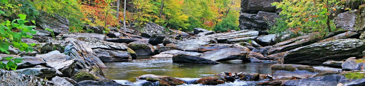

From Big Frog Mountain to Watauga Lake, fifteen different areas offer unique opportunities, activities and experiences across the Cherokee National Forest.
Choose an activity of interest in the left menu under “Recreation” or begin exploring the Recreation Map below. Click on the symbols to view recreation opportunities featured throughout the National Forest.
Enjoy your visit to the Cherokee National Forest.
RecAreaDirections
Open with Google Map
Misc
| Stay Limit | |
| Reservable | false |
| Keywords | |
| Map Link | |
| Contact Phone | |
| Contact Email |
Permits info
Facilities
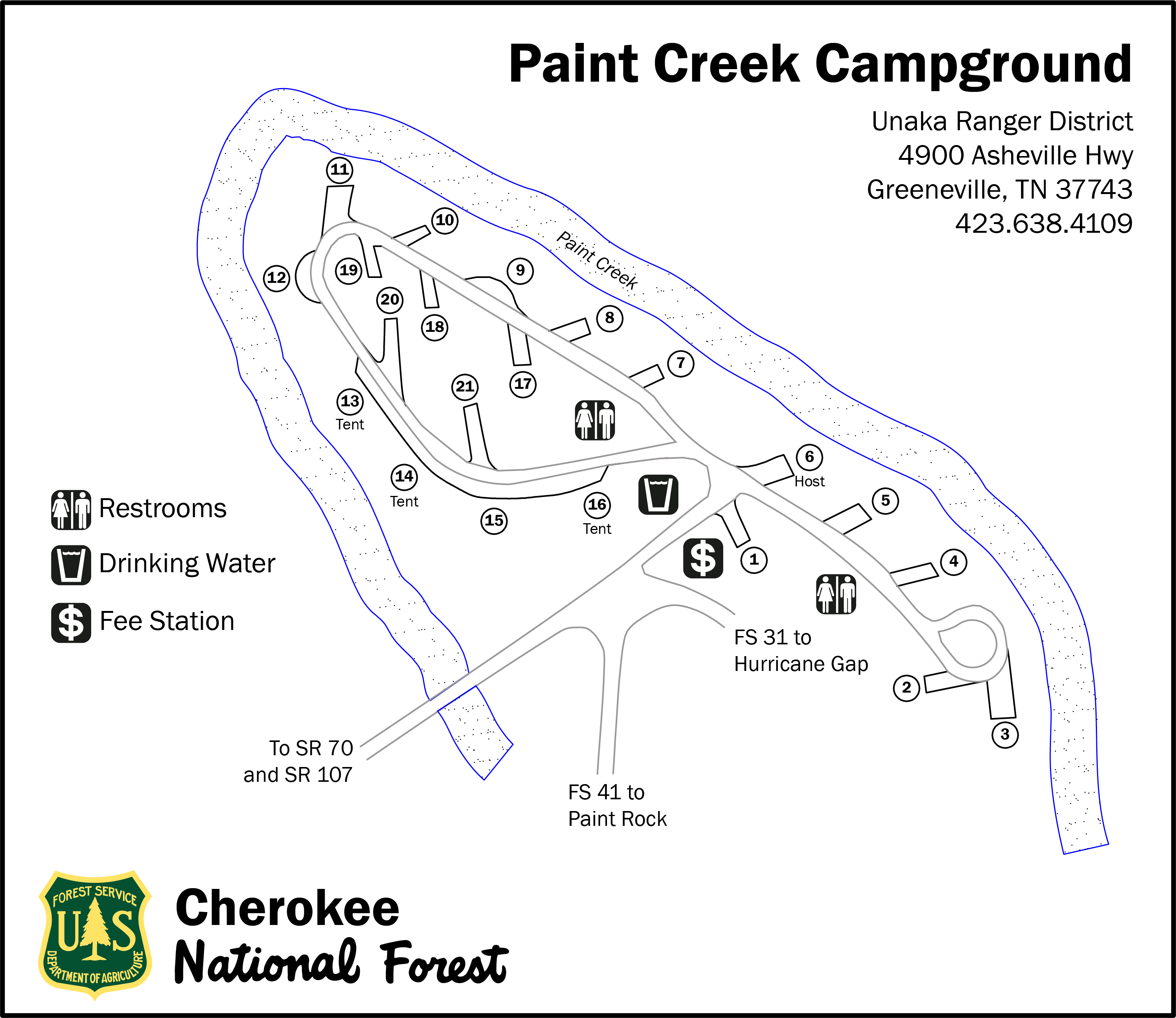
Paint Creek Campground Campground
List of CampsitesOverview
Paint Creek Recreation Area (elevation 1760 feet) is located in Greene County in a mountain cove along Paint Creek. A majority of the widely-spaced campsites have streamside views and are screened by a variety of native plants, including rhododendron, hemlock and laurel.
Recreation
Recreation opportunities abound along the Paint Creek corridor. Paint Creek is a popular stream for swimming, wading and fly fishing. TWRA stocks Paint Creek with Rainbow trout throughout the summer. Warm water fishing is a short drive away at Paint Creek Pond. Two hiking trails begin within walking distance of the campground: Paint Mountain Trail (#7) and Paint Creek Trail (#10). Bike riding along the Paint Creek corridor to Hot Springs, NC is becoming a favorite pastime. Several scenic auto loops can begin at Paint Creek campground.
Facilities
- 20 total campsites
- All single occupancy
- 3 sites (13, 14, and 16) are tent-only
- 2 vault toilets, one in each loop
- Drinking water available at the center of the campground
- Paint Creek Campground Map
Natural Features
- Waterfalls: Kelly, Dudley and Ricker Falls can be seen from Forest Road 41 along Paint Creek. Cascades: 15 feet each.
- Paint Creek Pond: Among the cattails and other aquatic plants, watch for beavers and listen for frog calls. In the early morning, watch mist rise from the placid surface of the pond. The pond is an easy drive or bicycle ride from Paint Creek Campground.
contact_info
Nearby Attractions
- French Broad River: Class I-III rapids. A popular commercial section runs 13 miles from Hot Springs, North Carolina, to Del Rio, Tennessee, with local rafting services.
- Scenic drives along Paint Creek Corridor with Hot Springs Loops - Meander along 5-mile Paint Creek Corridor to historic Paint Rock. Stop for a picnic, check out scenic waterfalls or splash in the ripples along the way. Extend your trip by travelling along French Broad River via River Road to the community of Hot Springs, North Carolina. Two overmountain routes will bring you back to Paint Creek:
- From Hot Springs, take US 25/70 west to TN 107 to Forest Road 54. Catch scenic mountain vistas along this winding gravel road that intersects Forest Road 41 near Paint Rock.
- From Hot Springs, take US 25/70 east to Forest Road 467 and wind through Pisgah National Forest to Hurricane Gap. Forest Road 31 brings you back to Paint Creek at Moses Turn trailhead. Take a side trip at Hurricane Gap to Pisgah National Forest’s Rich Mountain Firetower or catch the Appalachian National Scenic Trail #1.
Jacobs Creek Campground (TN) Campground
List of CampsitesOverview
Jacobs Creek Campground has closed for the season. Jacobs Creek Campground is situated along the shores of beautiful South Holston Lake in Sullivan County, Tennessee, at an elevation of 1,730 ft. With a view of miles of undeveloped shoreline and the water, the campsites at Jacobs Creek Campground are a relaxing way to spend your vacation. There are 27 available campsites, 23 of which are reservable, including warm showers in the campground. Campground hosts are available on site to answer your questions. There is a Day-Use area adjacent to the Campground with a designated beach area.
Recreation
Fishing is a popular activity for campers at Jacobs Creek. There is a boat launch a few miles down the road along Hwy 421. A few campsites have easy access to the lake shore. Children and adults enjoy riding their bikes on the roads between camping loops. There is also a day-use area adjacent to the campground for swimming and picnicking. There is an array of wildflowers to enjoy throughout the season, as well as resident deer and turkey and other natural wonders for the naturalist in your group. Jacobs Creek Shooting Range is about 1 mile outside the campground.
Facilities
There are a total of 29 campsites, 27 of which are available, within three loops. Some sites are right along the water, and some sites are away from the water. The campground has flush toilets and showers. Each site is non-electric, and contains a table, fire ring and lantern holder. Some sites can accommodate a travel trailer, while some sites are tent only. There is a boat launch a few miles down the road along Hwy 421.
Jacobs Creek Recreation Area Map
Natural Features
South Holston Lake is a 7,580-acre hydroelectric reservoir managed by the Tennessee Valley Authority and surrounded by the Cherokee National Forest. Holston Mountain and nearby Iron Mountain provide habitat for an array of wildlife including a healthy population of black bear.
Nearby Attractions
Jacobs Creek Campground is within 30 minutes of Bristol, Tennessee, and nearby Bristol Motor Speedway. Backbone Rock Recreation Area is approximately 30 minutes away up beautiful Shady Valley, and just five minutes past Backbone Rock is Damascus, Virginia. Little Oak Campground is 25 minutes away for another campground option along South Holston Lake.
Big Oak Cove Campground Campground
List of CampsitesOverview
This location is available on a first-come, first-served basis only. Visitors are required to physically arrive at the campground to purchase and claim a site. Once on-site, you may be able to pay for your campsite(s) by scanning a QR code using the Recreation.gov mobile app, and the Scan and Pay feature.
If this option is available, you will need to first download the free Recreation.gov mobile app https://www.recreation.gov/mobile-app prior to your arrival as some remote areas have limited or no cellular service.
Birch Branch Campground Campground
List of CampsitesOverview
This location is available on a first-come, first-served basis only. Visitors are required to physically arrive at the campground to purchase and claim a site. Once on-site, you may be able to pay for your campsite(s) by scanning a QR code using the Recreation.gov mobile app, and the Scan and Pay feature.
If this option is available, you will need to first download the free Recreation.gov mobile app https://www.recreation.gov/mobile-app prior to your arrival as some remote areas have limited or no cellular service.
Davis Branch Campground Campground
List of CampsitesOverview
This location is available on a first-come, first-served basis only. Visitors are required to physically arrive at the campground to purchase and claim a site. Once on-site, you may be able to pay for your campsite(s) by scanning a QR code using the Recreation.gov mobile app, and the Scan and Pay feature.
If this option is available, you will need to first download the free Recreation.gov mobile app https://www.recreation.gov/mobile-app prior to your arrival as some remote areas have limited or no cellular service.
Holder Cove Campground Campground
List of CampsitesOverview
This location is available on a first-come, first-served basis only. Visitors are required to physically arrive at the campground to purchase and claim a site. Once on-site, you may be able to pay for your campsite(s) by scanning a QR code using the Recreation.gov mobile app, and the Scan and Pay feature.
If this option is available, you will need to first download the free Recreation.gov mobile app https://www.recreation.gov/mobile-app prior to your arrival as some remote areas have limited or no cellular service.
Holly Flats Campground Campground
List of CampsitesOverview
This location is available on a first-come, first-served basis only. Visitors are required to physically arrive at the campground to purchase and claim a site. Once on-site, you may be able to pay for your campsite(s) by scanning a QR code using the Recreation.gov mobile app, and the Scan and Pay feature.
If this option is available, you will need to first download the free Recreation.gov mobile app https://www.recreation.gov/mobile-app prior to your arrival as some remote areas have limited or no cellular service.
Horse Creek Recreation Area Campground
List of CampsitesOverview
This location is available on a first-come, first-served basis only. Visitors are required to physically arrive at the campground to purchase and claim a site. Once on-site, you may be able to pay for your campsite(s) by scanning a QR code using the Recreation.gov mobile app, and the Scan and Pay feature.
If this option is available, you will need to first download the free Recreation.gov mobile app https://www.recreation.gov/mobile-app prior to your arrival as some remote areas have limited or no cellular service.
Jake Best Campground Campground
List of CampsitesOverview
This location is available on a first-come, first-served basis only. Visitors are required to physically arrive at the campground to purchase and claim a site. Once on-site, you may be able to pay for your campsite(s) by scanning a QR code using the Recreation.gov mobile app, and the Scan and Pay feature.
If this option is available, you will need to first download the free Recreation.gov mobile app https://www.recreation.gov/mobile-app prior to your arrival as some remote areas have limited or no cellular service.
Lost Corral Horse Camp Campground
List of CampsitesOverview
This location is available on a first-come, first-served basis only. Visitors are required to physically arrive at the campground to purchase and claim a site. Once on-site, you may be able to pay for your campsite(s) by scanning a QR code using the Recreation.gov mobile app, and the Scan and Pay feature.
If this option is available, you will need to first download the free Recreation.gov mobile app https://www.recreation.gov/mobile-app prior to your arrival as some remote areas have limited or no cellular service.
North River Campground Campground
List of CampsitesOverview
This location is available on a first-come, first-served basis only. Visitors are required to physically arrive at the campground to purchase and claim a site. Once on-site, you may be able to pay for your campsite(s) by scanning a QR code using the Recreation.gov mobile app, and the Scan and Pay feature.
If this option is available, you will need to first download the free Recreation.gov mobile app https://www.recreation.gov/mobile-app prior to your arrival as some remote areas have limited or no cellular service.
Old Forge Campground Campground
List of CampsitesRough Ridge Campground Campground
List of CampsitesOverview
This location is available on a first-come, first-served basis only. Visitors are required to physically arrive at the campground to purchase and claim a site. Once on-site, you may be able to pay for your campsite(s) by scanning a QR code using the Recreation.gov mobile app, and the Scan and Pay feature.
If this option is available, you will need to first download the free Recreation.gov mobile app https://www.recreation.gov/mobile-app prior to your arrival as some remote areas have limited or no cellular service.
Round Mountain Campground Campground
List of CampsitesOverview
This location is available on a first-come, first-served basis only. Visitors are required to physically arrive at the campground to purchase and claim a site. Once on-site, you may be able to pay for your campsite(s) by scanning a QR code using the Recreation.gov mobile app, and the Scan and Pay feature.
If this option is available, you will need to first download the free Recreation.gov mobile app https://www.recreation.gov/mobile-app prior to your arrival as some remote areas have limited or no cellular service.
Spivey Cove Campground Campground
List of CampsitesOverview
This location is available on a first-come, first-served basis only. Visitors are required to physically arrive at the campground to purchase and claim a site. Once on-site, you may be able to pay for your campsite(s) by scanning a QR code using the Recreation.gov mobile app, and the Scan and Pay feature.
If this option is available, you will need to first download the free Recreation.gov mobile app https://www.recreation.gov/mobile-app prior to your arrival as some remote areas have limited or no cellular service.
State Line Campground Campground
List of CampsitesOverview
This location is available on a first-come, first-served basis only. Visitors are required to physically arrive at the campground to purchase and claim a site. Once on-site, you may be able to pay for your campsite(s) by scanning a QR code using the Recreation.gov mobile app, and the Scan and Pay feature.
If this option is available, you will need to first download the free Recreation.gov mobile app https://www.recreation.gov/mobile-app prior to your arrival as some remote areas have limited or no cellular service.
BACKBONE ROCK RECREATION AREA PAVILIONS Campground
List of CampsitesOverview
The pavilion at Backbone Rock Recreation Area is a popular location for family reunions and other types of group gatherings. The pavilion is large and adjacent to an expansive field, Beaverdam Creek, and a large parking area. The area includes accessible grills, picnic tables, dumpsters, and vault toilets.
Recreation
There is a trail that will take you to the top of Backbone Rock, following a stone-step wooded path. The trail crosses the rock and leads to Beaverdam Creek or Backbone Rock Falls. The Appalachian National Scenic Trail adjoins Backbone Rock Trail. Beaverdam Creek is known for its excellent fishing.Facilities
There is a Civilian Conservation Corps (CCC) -era pavilion, picnic tables and grills. The pavilion includes a stone fireplace and several large picnic tables with additional tables and grills nearby. Vault toilets are located within the parking area, and are open for the 2022 season.
Natural Features
Backbone Rock Recreation Area is located along Beaverdam Creek in northern Johnson County. Backbone Rock gets its name from a spur ridge on Holston Mountain that ends abruptly at a bend in Beaverdam Creek. A tunnel was drilled through the rock in 1901 to allow railroad access between Shady Valley, TN and Damascus, VA. Motorists pass through what is locally known as "The shortest tunnel in the world" as they travel along TN 133.
Nearby Attractions
Damascus, Virginia is five miles North of Backbone Rock for any in-town needs.
THE LAURELS PICNIC AREA PAVILIONS Campground
List of CampsitesOverview
The Laurels Picnic Area Pavilions has closed for the season. The Laurels has been a popular area since the early days in East Tennessee. It was a common evening stopover for farmers from North Carolina taking produce to markets in Johnson City. The site is named for the native Rhododendron that thrives in the area, locally called "laurel." The Civilian Conservation Corps helped construct the current facilities in the early 1930's. Today, it is a popular day-use area, providing a nice shady place for family picnics and group gatherings.
Recreation
The Laurels has two pavilions, each with picnic tables and grills. An old foot path meanders through the nearby woods.Facilities
The Laurels includes two picnic pavilions, numerous tables, grills, a bear-proof dumpster, and connected by foot paths. There is a vault toilet on site. There is no potable water.
Natural Features
Honeycomb Creek flows through the picnic area and is enjoyed by kids of all ages on warm summer days.
WATAUGA POINT RECREATION AREA Campground
List of CampsitesOverview
Watauga Point Recreation Area is located on the southern shore of Watauga Lake in Carter County. Large shade trees scattered throughout grassy areas provide a park setting for picnicking and sunbathing. In addition to picnic facilities, there is a lake and a gravel trail that loops through the nearby forest. Flush toilets, sinks, and drinking fountain are all closed and winterized for the season.
Recreation
Boaters, anglers, and picnickers all enjoy Watauga Point. There is a wooded trail on site as well.
Facilities
Watauga Point Recreation Area has one pavilion with electricity, a shady area, accessible flush toilets, and several other picnic tables and pedestal grills spread throughout. There are six picnic tables and two large grills at the pavilion. The shady area has five picnic tables and two grills. The pavilion and shady area are both reservable. Please make sure you are reserving the right thing (either the pavilion or the shady area) when making your reservation.
Natural Features
At more than 1,900 feet in elevation, Watauga is the highest reservoir in Tennessee. This scenic 6,400-acre reservoir is managed for flood management, power generation, aquatic ecology and recreation. Watauga Point overlooks the reservoir and the Big Laurel Branch Wilderness Area on the opposite shore.
Nearby Attractions
Both water-based and land-based recreation activities abound near Watauga Point Recreation Area. Forest Service facilities within three miles include Cardens Bluff Campground, Rat Branch Boat Ramp, and Pond Mountain Shooting Range.LITTLE OAK CAMPGROUND Campground
List of CampsitesOverview
Lone Pine and Poplar loops have closed for the season. Hemlock and Big Oak loops are open until 11/7/22. Please note the showerhouse, water hydrants, and dumpstation may be winterized at any time on or after 10/11/22. Little Oak Campground hugs the shores and inlets of beautiful South Holston Lake in Sullivan County, Tennessee. With a view of the Holston Mountain ridgeline and lake islands, Little Oak campsites are a relaxing setting for your vacation. There are 69 universally accessible campsites improved in 2012 including warm showers and a paved access road. Campground hosts are available on site to answer your questions.
Recreation
Fishing is a popular activity for campers at Little Oak, with a concrete boat launch within the campground. Numerous campsites have easy access to the lake shore for tying off your boat. There are nearby trails for hiking and horseback riding. Children and adults enjoy riding their bikes on the roads between camping loops. There is also a lakeside grassy area popular for swimming and picnicking. There is an array of wildflowers to enjoy throughout the season, resident deer and turkey and other natural wonders for the naturalist in your group.Facilities
There are 69 universally accessible campsites for tents or RVs within four loops at Little Oak Campground. Each loop has a pair of vault toilets. In addition, there is an accessible shower house with 8 showers for the campground. There is a boat launch within the campground with an additional single vault toilet. The boat launch is for use by registered campers and their guests only.
Natural Features
South Holston Lake is a 7,580-acre hydroelectric reservoir managed by the Tennessee Valley Authority and surrounded by the Cherokee National Forest. Holston Mountain and nearby Iron Mountain provide habitat for an array of wildlife including a healthy population of black bear.Nearby Attractions
Little Oak Campground is within 30 minutes of Bristol, Tennessee, and nearby Bristol Motor Speedway. Backbone Rock Recreation Area is approximately 30 minutes away up beautiful Shadey Valley, and just five minutes past Backbone Rock is Damascus, Virginia. Jacobs Creek Campground and Swim Area is 25 minutes away for another view of South Holston Lake.
CARDENS BLUFF CAMPGROUND Campground
List of CampsitesOverview
Cardens Bluff Campground has closed for the season. At nearly 2,000 feet elevation, Cardens Bluff Campground is located on a peninsula overlooking the 6,430-acre Watauga Lake in Carter County, TN. There are 43 sites, primarily for tent camping. There is a bathhouse with showers and flush toilets. No electrical hookups are provided. Day use areas are located nearby for those wanting to take advantage of swimming, boating, and fishing opportunities. Campground Hosts are on site to answer questions and assist with your visit.
Recreation
Boating is popular for visitors to Cardens Bluff. Numerous campsites provide easy water access for kayaks, canoes and motorized boats. Swimming and fishing are also very popular activities at Cardens Bluff. Watauga Lake provides notably clean water for recreating.
Facilities
There are 43 campsites within Cardens Bluff Campground. Each section of the campground has flush toilets. In addition, there is an accessible shower house with eight showers for use by registed campers only.
Natural Features
Watauga Lake is a 6,430-acre hydroelectric reservoir managed by the Tennessee Valley Authority and surrounded by the Cherokee National Forest. Directly across the lake from the campground is the Big Laurel Branch Wilderness area, a rugged, undeveloped mountain range with only the Appalachian National Scenic Trail within its boundaries.Nearby Attractions
The nearby Rat Branch Boat Launch is an easy quick drive from the campground for campers with motor boats. Shook Branch Swim Area is also nearby on the shores of Watauga Lake. Big Laurel Branch and Pond Mountain Wilderness areas are located north and south of the campground for more rugged, backcountry hiking.
KATY BRANCH Campground
List of CampsitesOverview
Katy Branch, a former Youth Conservation Corp Camp, is a private outdoor pavilion surrounded by beautiful Tennessee woodlands in the Cherokee National Forest.Recreation
Forested land is available for hiking and exploration and an open area is available for group activities.Facilities
Rental facilities include an open pavilion with fireplace and three large picnic tables. The pavilion is attached to a building that contains two accessible restrooms and a "kitchen" area with stainless steel sink, microwave and refrigerator. A large outdoor charcoal grill and five folding tables and 80 folding chairs are also available with the rental. The pavilion is located about .5 miles on a gravel road, closed to the public.Natural Features
Katy Branch is located in open woodland. A more heavily forested area and an open area, part of which is used for parking, is adjacent to the pavilion area.Nearby Attractions
Katy Branch is located about half-way between the towns of Greeneville and Erwin. Though it is not located on the Nolichucky River, the river is only about .5 miles away.HOUSTON VALLEY Campground
List of CampsitesOverview
Houston Valley Recreation Area (elevation 1,800 feet) is centrally located to both Paint Creek and Weaver Bend. It is located directly off Tennessee (TN) Scenic Highway 107.Recreation
Equestrian trails and hiking trails are located close to the recreation area. An open grass area is available for games.Facilities
Houston Valley Recreation Area has eight picnic sites and two group picnic areas in addition to the pavilion. A green-space restroom and trash cans are located a short distance from the pavilion. The pavilion itself contains three large picnic tables and is located adjacent to two single tables with grills.Natural Features
The recreation area is nestled along the edge of a hardwood forest. Fall colors are spectacular along this stretch of TN Scenic Highway 107.Nearby Attractions
Meadow Creek, a Fire Tower that has recently been renovated as a lookout platform, is a short drive or hike away. Burnette Gap Trailhead is a short distance away. Bubbling Springs Rifle Range is located off TN Scenic Highway 107. Another scenic drive along Brush Creek Road (#209) leads to Weaver Bend and Allen Branch Pond. An accessible .2 mile trail rings Allen Branch Pond and Weaver Bend Road (#209C) parallels the French Broad River.Horse Creek Pavilion DAY USE Campground
List of CampsitesOverview
Horse Creek Pavilion is located eight miles from Greeneville, Tennessee. It is nestled into a hardwood cove beside its namesake, Horse Creek. The Civilian Conservation Corps (CCC) constructed the pavilion during the 1930s.Recreation
Hiking, water-play and fishing are popular activities. Scarlet Oak Trail (#181) is a .2 mile leg-stretcher through the forest bordering the recreation area. A more primitive hiking experience is available on three trails located in the nearby Sampson Mountain Wilderness. A small campground and more picnic sites are located in Horse Creek Recreation Area.Facilities
The picnic pavilion has three tables and a paved parking area nearby. A large grill and water source is located at the pavilion. Additional tables are located nearby, as are trash containers and a pit toilet. The walkways and many of the sites are accessible; however the restroom has limited accessibility.Natural Features
Horse Creek Pavilion is located close to Horse Creek and adjacent to Sampson Mountain Wilderness. It is located at the base of the Bald Mountains at an elevation of 1,720 feet.Nearby Attractions
Horse Creek is located near historic Greeneville, Tennessee, home of Andrew Johnson, 17th President of the U.S. Tusculum College is located nearby. Founded in 1794, it is the oldest College in Tennessee. The Andrew Johnson Homestead and several museums are located in Greeneville/Tusculum. Hotels, restaurants, grocery stores and gas stations are nearby.INDIAN BOUNDARY Campground
List of CampsitesOverview
Indian Boundary Recreation Area is the crown jewel of the South Zone of the Cherokee National Forest on the Tellico Ranger District. This family-oriented campground offers a swim beach and picnic area with grills and an accessible picnic pavilion, as well as a fantastic, 3.2-mile hiking and biking trail around the lake. Spectacular mountain views, glimpses of wildlife, and a peaceful setting await visitors who come to Indian Boundary.Recreation
Opportunities abound for fishing, swimming, boating, wildlife viewing and scenic driving. Other popular activities include hiking and biking the trail around Indian Boundary Lake.The recreation area contains a swim beach, boat ramp, fishing pier, picnic area and volleyball court.
Facilities
The 87-site campground has electric hookups, water faucets throughout the campground, grills, picnic tables and lantern posts. Modern restrooms add to the comfort of visitors in this natural setting.
An on-site campground store sells bread, ice, milk, ice cream and other camping supplies.
Indian Boundary Recreation Area Map
Natural Features
Indian Boundary Lake covers 96 acres at an elevation of 1,560 feet, and sits among hardwoods and pines. At the lake, visitors enjoy watching beaver that inhabit an adjacent pond, identifying several species of ducks and other waterfowl and trying their luck at catching bass, sunfish and catfish.The Cherokee National Forest is located in eastern Tennessee and stretches from Chattanooga to Bristol along the North Carolina border. The 650,000-acre swath of land is Tennessee's only national forest. It lies in the heart of the Southern Appalachians and is home to more than 20,000 species of plants and animals, as well as many rivers, creeks and lakes. Elevations range from 750 to 5,500 feet.
Nearby Attractions
The campground is two miles off the Cherohala Skyway, a 43-mile National Scenic Byway that stretches from Tellico Plains, Tennessee, to Robbinsville, North Carolina. Bald River Falls on Tellico River Road 210 is a popular destination. The Pheasant Fields Fish Hatchery also on Tellico River is operated by the Tennessee Wildlife Resources Agency and is the rearing pools for the fish stocking program on Tellico River, Citico Creek, and the Green Cove Pond.MCNABB CREEK GROUP Campground
List of CampsitesOverview
McNabb Creek Group Campground is located on the North River in the Tellico River area. Fishing, swimming, hiking and hunting are popular activities.Recreation
The North River offers plenty of fishing and swimming opportunities. Visitors also enjoy hiking local trails and seasonal hunting.Facilities
The campground offers one group site that can accommodate from 10 to 60 people. It is equipped with picnic tables, grills and portable toilets.Natural Features
The campground sits along the North River, a major tributary of the Tellico River, in the Smokey Mountains of the Cherokee National Forest in eastern Tennessee.Cherokee is Tennessee's only national forest, covering 650,000 acres from Chattanooga to Bristol along the North Carolina border. The forest is in the heart of the Southern Appalachians and is home to more than 20,000 species of plants and animals, as well as many rivers, creeks and lakes. Elevations range from 750 to 5,500 feet.
Nearby Attractions
The mountain town of Tellico Plains, less than 20 miles away, is known for its arts and crafts.The campground is 18 miles off the Cherohala Skyway, a 43-mile National Scenic Byway stretching from Tellico Plains, Tennessee, to Robbinsville, North Carolina.
DONLEY CABIN Campground
List of CampsitesOverview
Donley Cabin is a primitive and historic structure in the heart of the Cherokee National Forest, offering visitors a glimpse of the past. The cabin does not have electricity, running water or locks on the door. Guests should be aware that visitors often frequent the cabin during tours of the area. It predates the Civil War and is among the oldest cabins available for rental in the Forest Service system. The cabin offers access to a variety of recreational activities, including numerous trails and streams. Visitors must walk a quarter-mile from the parking area, along a slight grade and over a bridge on the North River, to the cabin. All equipment must be carried in. Guests are responsible for their own travel arrangements and safety, and must bring many of their own amenities. No pets are allowed except for service animals. The cabin is available by RESERVATION ONLY. Walk-ins are not allowed.Recreation
The one-room cabin contains a full-size metal bed and two bunk beds that can accommodate up to six people. All beds have bed frames but NO mattresses. There are hiking trails and fishing streams in close proximity to the cabin. The nearby Sycamore Creek Trail is a short drive north on Tellico River Road. The 2-mile trail starts near a picnic area and a fish hatchery and follows an old logging road and railroad bed along Sycamore Creek. Big Cove Branch, a tributary to the North River that contains two distinctive waterfalls and trout-fishing opportunities, is also not far from the cabin. Hunting is also a popular activity enjoyed by visitors to the area from September through December. Hunters and their dogs may frequent the nearby trails during that time.Facilities
The one-room cabin contains a full-size metal bed and two bunk beds that can accommodate up to six people. There is a rustic fireplace, kitchen table and chairs as well as rocking chairs available to sit on the cabin's front porch. An outhouse with a vault toilet, campfire ring and grill are available outside the cabin.Guests must bring their own water for drinking, cooking and cleaning purposes, as well as lanterns or flashlights, bedding, towels, cooking and eating gear, food, garbage bags, toilet paper and other necessities. Firewood that is dead and down may be obtained from the surrounding forest.
Natural Features
The restored cabin sits in a wooded area of the forest's Tellico River area, at an elevation of 2,000 feet. This part of the forest is known for its three rivers, their tributaries and waterfalls. The cabin is several miles north the 90-foot Bald River Falls. A variety of wildlife make its home in the area. The area is also known for its abundant brown, rainbow and book trout. Snakes and mice can be seen in the area as well. The surrounding foliage is beautiful in the fall.Nearby Attractions
Driving in or out, guests can visit the mountain town of Tellico Plains, which is known for its arts and crafts. Guest can also enjoy the Cherohala Skyway, the 43-mile National Scenic Byway that stretches from Tellico Plains, Tennessee, to Robbinsville, North Carolina.Big Bend Facility
Big Bend offers plentiful parking for those who are looking to fish the Hiwassee River.
Tellico River Corridor Facility
The Tellico River Corridor provides ample opportunities for day use.
Hiwassee River Facility
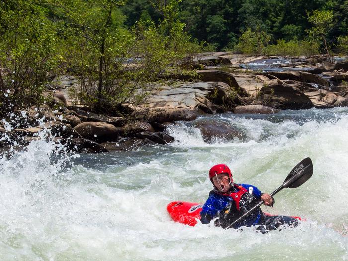
The Hiwassee River offers Class I-III rapids, and is a popular destination for fishing, kayaking, and tubing.
Local outfitters rent rafts and tubes, for a list of Outfitter and Guides, click HERE.
Additional information or release scedules for other locations can be found here: www.tva.org/
Bald Mountains Facility

Most of the area is remote backcountry, including Bald Mountain Ridge Scenic Area and Sampson Mountain Wilderness. Roads are limited, but forty-plus miles of trail access the forest.
The area is known for its diverse populations of wildflowers and a number of waterfalls, including 60-foot fan-shaped Margarette Falls and Sill Branch Falls. Try fishing Nolichucky River, Horse Creek, Dry Creek and Clark Creek. Horse Creek and Old Forge Recreation areas offer picnicking, water play and camping.
Dillard Place Facility
Grassy meadows and wooded hillsides surround a string of four small ponds, fed by the cold waters of Paint Creek. Just off Upper Paint Creek Road, this area is a great place for the whole family to explore.
Katy Branch Facility
This former YACC (Young Adult Conservation Camp) is available to rent for dinners, gatherings, weddings, etc. The facilities include an outdoor pavilion with a fireplace, a large charcoal grill, an attached "kitchen" and two restrooms. The "kitchen" contains a food prep area and a sink for washing dishes, there is no oven. Folding chairs and tables are available on-site.
The private camp is located behind a closed gate and can be rented for $75.00 per day. Reservations can be made on-line through Recreation.gov or call 1-877-444-6777.
French Broad River Area Facility

This area’s wooded mountainsides and creek gorges are linked by an extensive road and trail system. Activities include fishing, hiking, horseback riding, creek play and camping.
At Paint Creek, camping, fishing, swimming and picnicking are popular activities. Other water-based opportunities include driving along scenic Brush Creek or exploring warm-water Allen Branch or Paint Creek ponds. Enjoy the scenery from horseback on 35 miles of multi-use trails, also open to mountain bikers and hikers. The Appalachian Scenic Trail lies along the eastern edge of this area.
Brush Creek Mountain Driving Loop Facility
Travel along TN 107, Forest Road 209 (some portions are gravel) and US 25/70. FR 209 meanders through a narrow canyon with rhododendron-covered sandstone bluffs. Stretch and enjoy the short, accessible trail at Allen Branch Pond. French Broad Boat Launch offers access to the river. Stop for a picnic at Houston Valley Recreation Area off TN 107.
French Broad River Facility
The French Broad River has the distinction of being the third oldest river in the world and is one of the original rivers included in the Tennessee Scenic Rivers Act of 1968. Whether you're a history buff, a boater, an angler or a nature lover looking to catch a glimpse of a Blue Heron in flight, the French Broad River will not let you down.
Commercial rafting operations run 13 miles from Hot Springs, NC to Del Rio, TN with rapids ranging from class I - III. River access is available at Weaver's Bend and at the French Broad boat launch near Wolf Creek. The river itself supports a variety of warm and cool water fish including large and smallmouth bass, rock bass, catfish, crappie, bluegill, carp and sauger. Many of the tributaries of the French Broad River support trout as well. Opportunites for viewing nature and wildlife are available all along the river including Weaver's Bend and French Broad Fields.
The Cocke County Tennessee Chamber of Commerce websiteh as a list of local outfitter and guides for the French Broad River.
Paint Creek Corridor with Hot Springs Loops Facility
Meander along 5-mile Paint Creek Corridor to historic Paint Rock. Stop for a picnic, check out scenic waterfalls or splash in the ripples along the way. Extend your trip by travelling along French Broad River via River Road to the community of Hot Springs, NC.
Holston Mountain Area Facility

Holston Mountain provides a scenic backdrop for South Holston Lake and is a venue for boating, water skiing, swimming, fishing and horseback riding.
A horse trail complex winds for more than 30 miles along both sides of Holston Mountain. Visit the scenic Blue Hole waterfall located off TN Highway 91.
Camp on the lakeshore at Jacob’s Creek and Little Oak Recreation Areas.
Osborne Farm Facility

South Holston Lake Facility
Boat, kayak, water-ski and fish the meandering shoreline of this TVA lake. Launch your watercraft from Tennessee Wildlife Resources Agency’s ramp on US 421 or from Little Oak Campground off Forest Road #87. You can camp near the water at Little Oak and Jacobs Creek Campgrounds.Observation Knob at TVA’s South Holston Dam is a great place to view the lake against thebackdrop of Holston Mountain. Look for bald eagles, reintroduced in the 1990s. Loons, buffleheads, mallards and ring-billed gulls are among the area’s waterfowl species.
Iron Mountains Facility

Rugged mountain solitude can be experienced throughout this area. Long distance backpacking, trout fishing and the shortest tunnel in the world are a few features you can find here.
The Osborne Farm offers a panoramic view of the surrounding mountains from the Appalachian National Scenic Trail (A.T.). From there, take a multi-day backpack trip along the A.T. and Iron Mountain Trail. Try your hand at trout fishing in Beaverdam and Laurel Creeks. Camp at Backbone Rock Recreation Area and explore what is known locally as the shortest tunnel in the world.
TN 91 Scenic Drive Facility
Wind along Stony Creek through farmlands framed by Holston and Iron Mountains to the top of Cross Mountain. Cross Mountain Trailhead offers area information, as well as parking for Appalachian National Scenic Trail #1 and the Osborne Farm. TN 91 drops spectacularly into Shady Valley, a rural farming community known for its extant cranberry bogs. North of Shady Valley, TN 133 follows portions of an old rail line along Beaverdam Creek through the Shortest Tunnel in the World at Backbone Rock Recreation Area.
Pigeon River Area Facility

Favorite activities in this remote area include whitewater rafting, hiking and camping.
Located between the French Broad and Pigeon Rivers, this area offers pockets of backcountry nestled among the rural communities of Cocke County, TN. This area is home to Catherine Marshalls’s novel Christy and the historic Wasp Community. Hike a section of the Appalachian Trail and other forest trails. Camp at Round Mountain, rated as the number one tent campground in Tennessee. Explore Martha Sundquist State Forest and contact local outfitters to help guide your whitewater adventure.
Max Patch Facility

Pigeon River Facility
Named for the extinct passenger pigeon whose migration routes traversed this area, the Pigeon River is now a popular recreation destination for fisherman and river rafters alike.
Fisherman can catch smallmouth bass on the river all year long. If rafting is more appealing to you, this dam controlled river is divided into two sections (upper & lower). The upper section runs from just below the Walters power plant at Waterville, NC five miles through class III & III+ rapids to the takeout at Hartford ,TN. The lower section, almost five additional miles, starts in Hartford and runs through class II & III rapids to the lower takeout, just before Denton, TN. Contact any of the local guides and outfitters for additional information.
The Cocke County Tennessee Chamber of Commerce website contains a list of local outfitter and guides for the French Broad River.
Roan Highlands Facility

This area's steep rugged mountainsides, high-elevation balds and hollows are richly diverse, home to unique and rare plants and animals.
Look for rock outcrops, lush wildflower displays and high-elevation mountain balds and spruce-fir forests. In June, experience some of the most prolific Rhododendron bloom in the region. Hike for one day or several on the Appalachian National Scenic Trail.
Unaka Mountains Facility

Backcountry trails, scenic driving and the Nolichucky River provide opportunities for outdoor adventure. High elevation balds along the Unaka Mountain Range offer spectacular views.
Look for Pinnacle Mountain Fire Tower located on the crest of Buffalo Mountain. The zone is rich with Civilian Conservation Corps history: view their legacy at Laurels, Rock Creek and Unaka Mountain Road. Enjoy picnicking at Laurels, Limestone Cove, Rock Creek and Chestoa or camp at Rock Creek Recreation Area.
Nolichucky River Facility
Class II-V rapids through remote backcountry in the Pisgah and Cherokee national forests and Class I-II rapids between Erwin, Tennessee, and Davy Crockett Lake near Greeneville, Tenn. Commercial rafting is available on the challenging 8.5-mile section between Poplar, N.C. and Erwin.
The Unicoi County Chamber of Commerce website contains a list of outfitter and guides for the Nolichucky River.
Unaka Mountain Scenic Drive Facility

From Erwin, this drive makes a circle connecting TN 395, graveled Forest Road 230 and TN 107, a state scenic parkway, past Limestone Cove.
The route winds from the valley floor of Unicoi County to high-elevation spruce forests and balds atop Unaka Mountain. Rock Creek Recreation Area, with facilities for day and overnight use, and Limestone Cove Picnic Area are along the way. High-clearance 4WD vehicles are recommended on Forest Road 230, closed between mid-December to mid-March.
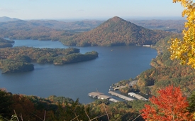
Watauga Lake Area Facility

Water recreation is abundant in this area, featuring Watauga Lake; the Doe, Elk and Watauga rivers; several streams and seven waterfalls.
Highly developed recreation areas along Watauga Lake provide facilities for fishing, picnicking, swimming and boat launching. The Appalachian National Scenic Trail runs through the area's backcountry. Camp on the lakeshore at Cardens Bluff or in the backcountry along Laurel Fork Creek at Dennis Cove.
US 321/TN 67 Scenic Drive Facility
These state scenic parkways follow the shoreline of Watauga Lake, accessing several national forest recreation areas and providing scenic views of the lake and forest lands on Iron Mountain. The highways split east of the lake, where both individual routes pass through farmlands, rural communities and scenic mountain views toward Boone, NC and Mountain City, TN.
Watauga Lake Facility
In 1942, TVA impounded Elk River, Roan Creek and Watauga River to create this 6,430-acre lake. Nestled between Big Laurel and Pond Mountain wildernesses, the deep blue waters and beautiful mountain vistas set the stage for fishing, boating and water skiing. A network of developed sites including boat launches, picnic areas and a campground are provided by the Forest Service. Hike the Appalachian National Scenic Trail #1 to follow the west and north sides of the lake. In late spring, listen for yellow-throated warblers and vireos at Rat Branch Boat Launch and Watauga Point Picnic Area.
Watauga River Facility
No information available at this time.
Big Frog Area Facility

This area is known for solitude and backcountry adventure, with Big Frog Wilderness being a destination for backpacking, day-hiking and hunting.
The area offers about 35 miles of backcountry trails, some of which climb to over 4,000 feet. In addition to the backcountry hiking opportunities, the area is also managed as a Black Bear reserve. Try snorkeling at Conasauga River, renowned for remarkable fish viewing. Pitch a tent at Tumbling Creek or Sylco Campgrounds.
Falls Branch Falls Hike Facility

Celebrate the 50th Anniversary of the Wilderness Act by taking a day hike to Falls Branch Falls located in the Citico Creek Wilderness.
To help visitors plan their adventure and enjoy this featured day hike, Johnny Molloy, Outdoor Writer & Board Member of Partners of the Cherokee National Forest, has provided an excerpt from his book, Waterfall Hiking Tennessee, Falls Branch Falls Hike.
The Falls Branch Trail #87 is a 1.3-mile trail (2.6-mile round trip) that leads to Falls Branch Falls, a 70-foot waterfall. Please note that this trail is located within congressionally designated Wilderness, a primitive area where trail signing and blazing are minimal.
The majority of the trail follows an old roadbed, but it eventually leaves the roadbed and becomes narrow, steep, and rocky closer to the waterfall.
Citico Creek Area Facility

This area provides opportunities for solitude and backcountry experiences. You will find ample opportunities for fishing, horseback riding, camping, and hiking.
With more than 20,000 acres of Wilderness in Citico Creek and Joyce Kilmer-Slickrock, this area provides ample opportunities for solitude and backcountry experiences. Catch both native and stocked trout in Citico Creek and its rugged tributaries, and fish for small-mouth bass and catfish in the creek’s lower reaches.
Coker Creek Area Facility

Heritage and culture experiences are the primary emphasis in this area. It is home to the nationally recognized Millennium Trail, The Unicoi Turnpike and gold panning opportunities.
Looking for a cultural heritage excursion? Pan for gold in the community of Coker Creek. Hike a portion of the Unicoi Turnpike, an ancient travel route once part of the Trail of Tears and now a nationally designated Flagship Millennium Trail. Visit the waterfalls in Coker Creek Scenic Area and drive along Hiwassee Scenic River on TN 68.
Hiwassee River Area Facility

Forested hillsides and pastoral river bottoms complement the beauty of Hiwassee River Gorge. Fishing, rafting, canoeing and hiking are popular activities.
The 21-mile John Muir National Recreation Trail , a section of the longer distance Benton MacKaye Trail, meanders along the river. Camp at the nearby state campground at Gee Creek.
Fish Your National Forests: This site can be accessed by Passenger Car; Fish available include: Trout; Types of fishing available include: Wade, Shore, Motorized boat, Fly; Boat Launch available
Hiwassee River Picnic Area Facility

Located on the Hiwassee River just off State Highway 30, this beautiful picnic area has well spaced sites situated among large oaks, hickories and beeches.
Visitors can explore several trails in the area. The Fisherman's Trail offers the angler opportunites to cast his line at one of the many popluar fishing spots. Spanking Stump Trail is a short interpretive hike and Oswald Dome Trail takes hikers to the top of Oswald Dome (elevation 3,000 ft.). Wildlife openings and abundant wildflowers in the spring are combined with several vistas of the Hiwassee River.
Ocoee River Area Facility
World class whitewater, mountain biking trail systems, environmental education programs, highly developed camping, and scenic byways are a few activities featured in the Ocoee River area.
Local outfitters offer rafting excursions in the Ocoee River’s world-class whitewater. The Ocoee Whitewater Center is a hub for outdoor adventure and offers regional information, environmental education, trails and picnic sites. Bike the 30-mile Tanasi Trail complex and trails at Chilhowee Recreation Area or take a scenic drive along the Ocoee Scenic Byway (US 64 and Forest Road 77). Popular camping areas include Parksville and Thunder Rock Campgrounds, as well as Chilhowee Recreation Area.
Clemmer Trailhead Facility
The Clemmer Trailhead is a primary access point to the Chilhowee Trails System, and is easily accessed off of Highway 64.
McKamy Lake Facility
Visitors to Chilhowee Recreation Area are drawn to McKamy Lake for swimming, fishing picnicking, sunbathing and canoeing. The seven-acre lake was built in the late 1930s to early 1940s by the Civilian Conservation Corps. Chilhowee Lake Trail skirts the banks of the lake and connects to picnic, bathhouse and campground facilities.
Ocoee River Facility
A thrill a minute Class III-IV rapids make the Ocoee one of the best whitewater rivers in the south. With two distinct sections available for rafting/canoe/kayaking, you can spend anywhere from 3 hours to all day on the river. The Ocoee was home of the 1996 Olympic canoe and kayak slalom events and that venue can be visited at the Ocoee Whitewater Center. Outfitters provide rafting services on both the upper and lower sections.
For a list of Outfitter and Guides on the Ocoee River, please click HERE.
Ocoee River Water Release Schedules:
Ocoee #3 - Upper River Section (Includes Ocoee Whitewater Center 1996 Olympic Course)
Ocoee #2 - Middle River Section
Additional information or release scedules for other locations can be found here: www.tva.com
Ocoee Scenic Byway Facility

The first designated national forest scenic byway in the nation includes 26 miles of US 64 and Forest Road 77.
The two-lane route winds past Parksville Lake, through the scenic rocky bluffs of Ocoee River Gorge and past the Ocoee Whitewater Center. Take a side trip up the 7-mile Chilhowee Scenic Spur, Forest Road 77, to Chilhowee Recreation Area. Take in long-range views of the Tennessee Valley, Cumberland Mountains and into the mountains of Georgia. From several overlooks you can spread a picnic or take a short hike.
Starr Mountain Area Facility

Starr Mountain is a popular area of the national forest for horse riding & camping with nearly 20 miles of trails and a number of roads available for riding. Lost Corral Campground & Trailhead provides the easiest access to the area.
This zone also features Gee Creek Wilderness and the Gee Creek Trail #191 trail that only gets more challenging the further you hike. Access is located off US Highway 411 near the Hiwassee River and state managed Gee Creek Campground.
Spring Creek Shooting Range Facility
A nice covered facility with both rifle and pistol ranges. Three target holders are available for practice shooting. Each target holder has a trail lead into the target holder. Please use caution in shooting range area and pick up your spent casings and trash before you leave. Camping is available at Gee Creek Campground or along Spring Creek. Picnic Areas and river opportunities are available on the Hiwassee River.
Gee Creek Falls Hike Facility

This trail lies almost entirely inside the Congressionally designated Gee Creek Wilderness. Trail length to the falls is approximately 1.3-miles from the trailhead, making it a 2.6-mile roundtrip hike.
To help visitors plan their adventure and enjoy this featured day hike, Johnny Molloy, Outdoor Writer & Board Member of Partners of the Cherokee National Forest, has provided an excerpt from his book, Five Star Trails: Chattanooga, Gee Creek Falls Hike.
Point of Interest: Remnants of Mining in Wetmore
Look for the concrete water diverter in Gee Creek that was used to wash mined silica, which provided flux for furnaces processing copper. The mining occurred around the 1890s when the railroad provided a new option to access the Copper Basin in addition to the Copper Road (now US Highway 64).
Bald River Falls Facility

The 90 foot high Bald River Falls is recognized as one of the most spectacular waterfalls in the region. It is easily accessed from Tellico River Road (NFRS 210), and provides outstanding photographic opportunities. Parking is limited, and visitor use is high on weekends and holidays. If possible, plan your visit during weekdays.
Big Oak Cove Campground Campground
List of CampsitesLooking to camp where you can wake at the crack of dawn and start fishing? The cool waters of the Tellico River just feet away will ease you to sleep each night. This is one of several small campgrounds on Tellico River Road (FS Rd 210). This campground offers 11 campsites with a picnic table, fire ring, and lantern post.
Cherohala Skyway Facility

View some of the best mountain scenery in the world from this 43-mile National Scenic Byway through the Cherokee and Nantahala national forests.
Drive along the sparkling rush of the Tellico River, stop at overlooks to take in expansive views of the Tennessee Valley and waves of mountain peaks, hike to high elevation mountain balds or nearby Joyce Kilmer Memorial Forest. Stop for a picnic at Indian Boundary Recreation Area.
For addtional information on the Cherohala Skyway, visit the official website HERE.
Tellico River Area Facility
This area provides outstanding opportunities for fishing, camping, hiking, and scenic driving. It is also home to the popular Indian Boundary Recreation Area and the Cherohala Skyway.
Nearly 30,000 acres of remote backcountry surround three rivers and their tributaries, where fishing for brown, rainbow and brook trout is excellent. Cherohala Skyway (TN 165/NC143), a 43-mile National Scenic Byway, winds between Tellico Plains, Tenn. and Robbinsville, N.C. Tellico River Road (FR 210) offers intimate views of the river and 90-foot Bald River Falls.
Spend the night at the historic Donley Cabin and check out CCC structures at Tellico Ranger Station and Dam Creek Picnic Area. Hike across the area on the Benton MacKaye Trail. Camp at sites along Tellico River or in Indian Boundary Recreation Area just off Cherohala Skyway.
Indian Boundary Lake Facility
This 96-acre lake provides a scenic backdrop for camping, fishing, picnicking and boating from the hub at Indian Boundary Recreation Area. The lake features a sandy swim beach, boat launch and accessible fishing pier. From the 3.6-mile lakeshore trail, you can watch beaver that inhabit a pond above the lake, identify several species of ducks and other waterfowl or try your luck at catching bass, catfish and bluegill.
Pheasant Fields and TWRA Tellico Fish Hatchery Facility
Pheasant Fields offers picnicking and access to Tellico River for waterplay.

To learn more about the Tellico Trout Hatchery, click HERE.
Tellico River Facility
Tellico River is primarily known for its incredible fishing opportunites. Fishing rules and regulations on the Tellico River are managed through the Tennessee Wildlife Resources Agency. For a full list of these rules and regulations, please visit TWRA's website HERE.
With its Class II-IV rapids, it is also known for its whitewater opportunities. It is best paddled in the spring or during times of the year when there is adequate rainfall. For more information abuot whitewater on the Tellico River, visit www.americanwhitewater.org.
Tellico River Road Facility
Take TN 165 from Tellico Plains to Forest Road 210. The route follows Tellico River past Bald River Falls, where you can pull off to view the magnificent falls. A few miles farther, stop to view pools of teeming trout at historic Pheasant Fields Fish Rearing Pools. Small campgrounds, picnic areas and trailheads flank this scenic route.
Ocoee Ranger Station Facility
The Ocoee Ranger Station can provide additional visitor information, and has an outlet that sells maps, books, passes, and permits.
Dam Creek Walk-In Campground and Picnic Area Campground
List of CampsitesThis Civilian Conservation Corps (CCC) site offers a quiet retreat for picnicking and camping.
Apalachia Powerhouse Launch Facility
This is a popular launch ramp for the Hiwassee River Gorge.
Towee Creek Launch Facility
The Towee Creek Launch serves a popular launch point, a picnic area, and a trailhead for the John Muir Trail.
Walnut Grove Picnic Area Facility
This small, shaded picnic area is offers an alternative picnic area for those who want to get away from the summer heat.
Baby Falls Day Use Site Facility

The Baby Falls Day Use Site, offers picnicking and water play nearby the popular Bald River Falls.
Green Cove Pond Facility
The Green Cove Pond is managed by the Tennessee Wildlife Resources Agency (TWRA). It offers fishing limited to handicapped individuals, children 12 years of age and under, and adults over 65 years of age. Consult TWRA Fishing Regulations for more information
Chestoa Overlook Facility
This is a 1.8 mile hike (one-way) along the Appalachian National Scenic Trail to vista points overlooking the Nolichucky River Gorge.
Dudley Falls Facility
Swim area and fishing access.
Unaka Ranger Station Facility
The Unaka Ranger Station can provide additional visitor information, and has an outlet that sells maps, books, passes, and permits.
Hood Mountain Overlook Facility
This picnic area offers views of the Hiwassee River Gorge.
Childers Creek Trailhead Facility
Childers Creek is a parking area for those to access the Hiwassee River and the John Muir Trail.
Moses Turn Facility
Parking for fishing and trail access.
Paint Creek Picnic Area Facility

Picnic area along Paint Creek. A short accessible trail along Paint Creek can be used to access these sites.
Watauga Ranger Station Facility
The Watauga Ranger Station can provide additional visitor information, and has an outlet that sells maps, books, passes, and permits.
Carver's Gap Facility
Explore the high mountain balds from this gap at Roan Mountain. Step onto the Appalachian National Scenic Trail from this site or continue a few short yards up the mountain and across the state line into North Carolina and the Rhododendron Gardens area.
Bald River Gorge Day Hike Facility

To help visitors plan their adventure and enjoy this featured day hike, Johnny Molloy, Outdoor Writer & Board Member of Partners of the Cherokee National Forest, has provided an excerpt from his book, Waterfall Hiking Tennessee, Bald River Falls and Middle Bald River Falls Hike.
Trail #88, Bald River is approximately 5.6-miles one way. It generally follows Bald River through the gorge from a parking area at Bald River Falls located on Forest Road 210 (Tellico River Road) to Forest Road #126 (Bald River Road) near Holly Flats Campground.
From Bald River Falls parking area, the trail follows a railroad grade constructed during historic logging operations. The first part of the trail is delineated by narrow gauge railroad track posts connected by logging chains to encourage visitors to stay on the trail. Vistors can hike out and back or make plans to be transported from the trail's terminus at Forest Road 126.
CHILHOWEE GROUP CAMP Campground
List of CampsitesOverview
Located in the Chilhowee Recreation Area, Chilhowee Group Camp offers camping for up to 75 individuals. Nearby McKamy Lake offers a swim area with a sandy beach and fishing from the bank. On the drive up to the campground, stop at one of the many observation overlooks to enjoy the beautiful mountains. Wildlife is abundant in this area, so have your camera ready and tread lightly.Recreation
Within the recreation area are approximately 25 miles of hiking and biking trails including the Chilhowee Trails System. Chilhowee Group camp is an excellent location for wildlife viewing and accessing a nearby scenic waterfall. Fishing is available on the seven-acre McKamy Lake. Boats are allowed, but gasoline motors are not.Facilities
The group camp includes a large open area with picnic tables and a grill as well as an RV site with electric hook up. Camp sites are scattered through the trees surrounding the RV site. Within the group site itself, a waterless vault toilet is available year-round. During the warmer months, (typically April-October), a bathhouse with flushing toilets and showers is available nearby.Both the beach and many trails are located within a short walking distance of the site.
Drinking water is available near the entrance to the group site.
Natural Features
The campground is located near the top of Chilhowee Mountain at an elevation of 2,000 feet. It is in a mixed hardwood and pine forest and the lake is a short walk from the group camp.Nearby Attractions
In addition to the immediate local activities, world class whitewater rafting opportunities are nearby on the Ocoee and Hiwassee Rivers.Charges & Cancellations
Goup areas must be cancelled more than 14 days from reservation date to get refund. The $8.00 service fee will still be charged for the reservation
QUINN SPRINGS PAVILION Campground
List of CampsitesOverview
The Quinn Springs Pavilion offers a covered picnic shelter for up to 50 people -- the perfect location for family reunions and church picnics.Recreation
The Hiwassee River is a popular fishing destination and is located across the highway from Quinn Springs Pavilion. Nearby outfitters offer equipment rentals for rafting or kayaking and there is access to three hiking trails nearby.Facilities
The pavilion is covered and seats about 50 people. The site offers a large and small charcoal grill and other picnic sites are nearby if needed. There is a waterless, vault toilet. Come prepared with water as there is no potable water on site. Visitors may park in the graveled parking area.Natural Features
Named for the seeping spring just above it on the mountain side and nestled across the road from the Hiwassee State Scenic River, this covered pavilion is surrounded by a grove of large white oaks, hickories, and yellow poplars.Nearby Attractions
Hiwassee State Scenic River, Oswald Dome Trail, Fisherman's Trail and Lowery Falls Trail are all nearby. Reliance Historic District is only a short drive away.PARKSVILLE LAKE RV CAMPGROUND Campground
List of CampsitesOverview
Located near Parksville Lake, Parksville Lake RV Campground offers well-shaded and nicely spaced campsites accommodating larger RVs. Several sites offer the opportunity for two RVs to camp close together and several are located along a small stream.Recreation
Parksville Lake RV Campground is central location for day trips to the many inviting outdoor recreation opportunities in the area. Visitors to nearby Parksville Lake will enjoy beaches for swimming and boat ramps for water access. The area boasts many miles of mountain bike and hiking trails. Whitewater rafting enthusiasts will want to check out the Ocoee Whitewater Center.Facilities
Picnic tables, grills, and lantern posts are located at each site. A bath house providing flush toilets and warm showers is centrally located in the middle of the loop. Water hydrants are located throughout the campground. An RV dump station is located near the entrance/exit.
Parksville Lake Campground Map and Guide
Natural Features
The Cherokee National Forest is located in eastern Tennessee and stretches from Chattanooga to Bristol along the North Carolina border. The 650,000-acre swath of land is Tennessee's only national forest. It lies in the heart of the Southern Appalachians and is home to more than 20,000 species of plants and animals, as well as many rivers, creeks and lakes.Nearby Attractions
The campground is conveniently located near the Ocoee River and the Ocoee Whitewater Center (site of the 1996 Olympic Kayak events).
CHILHOWEE CAMPGROUND Campground
List of CampsitesOverview
Located in the Chilhowee Recreation Area, Chilhowee Campground offers a multitude of camping opportunities for both RV and tent sites, many with electric hookups. The day-use area includes McKamy Lake, a swim area with sand beach, picnic sites, a group picnic area, and a bathhouse.
Be Aware; Do not use GPS directions: GPS coordinates will direct you up Benton Springs Rd. This route is not recommended. We recommend using Forest Service Road 77 to reach the recreation area. It's important to note, this facility requires driving 7 miles up to Chilhowee Campground on a narrow, winding road. Do not use the Benton Springs Access Road to the campground as this is an unpaved and dangerous road for RVs. Inexperienced RV drivers may have difficulties getting to and around the site.
Recreation
Chilhowee Recreation Area is an excellent hub for hiking and mountain biking in the Chilhowee Trails System, fishing in McKamy Lake, and wildlife viewing without having to get in your car. The 7-acre McKamy Lake offers a swim area with a sand beach, and fishing from the bank. Boats are allowed, but gasoline motors are not. Within the recreation area are approximately 25 miles of hiking and biking trails, and a scenic waterfall. The views and lake are beautiful, especially hiking to Benton Falls via a 1.5 mile in and out moderate trail. On the drive up to the campground, stop at one of the many observation overlooks to see beautiful mountain settings. Wildlife is abundant in this area, so have your camera ready and tread lightly.
Chilhowee Recreation Area Map and Guide
Facilities
Picnic tables, grills, and lantern posts are located at each site. Bathhouses providing flush toilets and warm showers are available in each loop, as well as in the day use area. Water hydrants are located throughout the campground. An RV dump station is located at the end of E Loop. Loops A and B offer walk-in tent sites with electricity.
Be Aware; Do not use GPS directions: GPS coordinates will direct you up Benton Springs Rd. This route is not recommended. We recommend using Forest Service Road 77 to reach the recreation area. It's important to note, this facility requires driving 7 miles up to Chilhowee Campground on a narrow, winding road. Do not use the Benton Springs Access Road to the campground as this is an unpaved and dangerous road for RVs. Inexperienced RV drivers may have difficulties getting to and around the site.
Natural Features
The Cherokee National Forest is located in eastern Tennessee and stretches from Chattanooga to Bristol along the North Carolina border. The 650,000-acre swath of land is Tennessee's only national forest. It lies in the heart of the Southern Appalachians and is home to more than 20,000 species of plants and animals, as well as many rivers, creeks and lakes.
Nearby Attractions
In addition to the immediate local activities, world class whitewater rafting opportunities are nearby on the Ocoee and Hiwassee Rivers.DENNIS COVE CAMPGROUND Campground
List of CampsitesOverview
Dennis Cove Campground has closed for the season. Dennis Cove Campground is a secluded campground along Laurel Fork Creek at an elevation of 2,650 feet in Carter County. This remote developed campground is popular with those seeking a rustic experience. The altitude, creek side location and lush forest surroundings make Dennis Cove particularly desirable during hot summer months. With 15 campsites, Dennis Cove is a great option for family camping.
Recreation
Along with camping, Laurel Fork Creek is stocked with rainbow trout below the campground. Above the campground, the creek and its tributaries are managed as wild trout streams for brown, rainbow and brook trout. Laurel Fork Trail (#39) follows the creek upstream for 8.0 miles with twenty-six stream crossings. The Appalachian National Scenic Trail is accessed one mile west of the campground along Dennis Cove Rd, or at the top of the nearby Coon Den Falls Trail (#37).
Facilities
There are 15 single campsites, including two double sites within Dennis Cove Campground. The campground has flush toilets. Each site contains a table, fire ring and lantern holder.
Natural Features
Dennis Cove Campground is located along the beautiful Laurel Fork Creek nestled in the mountains of the Southern Appalachians.Nearby Attractions
The trailhead for Coon Den Falls Trail (#37) is next to Dennis Cove Campground, and the trailhead for the Appalachian National Scenic Trail (#1) is approximately one mile west of the campground on Dennis Cove Rd. Watauga Lake is approximately 25 minutes away.
BACKBONE ROCK CAMPGROUND Campground
List of CampsitesOverview
Backbone Rock Campground has closed for the season. Backbone Rock Campground is a small campground situated along the beautiful Beaverdam Creek at an elevation of 2,100 feet in northern Johnson County. This developed campground is popular with those visiting the nearby Backbone Rock, a tunnel originally blasted through the rock ridge for the railway. The creek side location with popular swim area and lush forest surroundings make Backbone Rock Campground particularly desirable during hot summer months. With 10 campsites and an adjacent large Civilian Conservation Corps- built reservable pavilion with lawn, Backbone Rock is a great option for a group to reserve the whole campground for retreats and other events.
Recreation
Along with camping, Beaverdam Creek is stocked with trout. The Appalachian National Scenic Trail is accessed via the Backbone Rock Trail (#53).
Facilities
There are 10 single campsites, including two double sites within Backbone Rock Campground. The campground has flush toilets. Each site contains a table, fire ring and lantern holder.Natural Features
Backbone Rock Campground is located along the beautiful Beaverdam Creek nestled in the mountains of the Southern Appalachians.Nearby Attractions
The trailhead for the Backbone Rock Trail (#53) is approximately a quarter mile South of the campground on TN Highway 133. This trail is 4 miles and at the end of the trail is where it joins into the Appalachian National Scenic Trail (#1) Damascus, VA is approximately 5 minutes North of the campground. The Backbone Falls Trail (#198) is approximately a third of a mile South of the campground. This 0.4 mile loop trail takes you to the top of Backbone Falls.
Little Milligan Boat Launch Facility
Little Milligan Boat Launch is located on the Eastern half of Watauga Lake off US 321 and Moody Road.
Rat Branch Boat Launch Facility
Located just east of the town of Hampton, Tennessee, Rat Branch Boat Launch is a popular location for boaters of all sorts. There is a fishing pier on site.
Sink Mountain Boat Ramp Facility
Sink Mountain Boat Ramp is located at the end of the paved Forest Road 298 off TN Hwy 167.
THUNDER ROCK CAMPGROUND Campground
List of CampsitesOverview
Thunder Rock Campground is located 1.8 miles northwest of the Ocoee Whitewater Center, just behind TVA Ocoee Powerhouse Number 3. Nestled alongside the Ocoee River, this facility provides 37 regular campsites for popups and RVs less than 20 feet with no elctricity , ONLY site 9 is an electric site for less than 20 feet at 30 amp, and one group campsite. Thunder Rock is a popular destination for both whitewater and trail enthusiasts.
Recreation
Trailhead parking is available for the nearby Tanasi trail system, which includes approximately 30 miles of hiking and mountain biking trails. This system can be reached via Thunder Rock Express, Dry Pond Lead, or the Rhododendron Trail. Thunder Rock also provides access to the Benton-McKaye Trail.Facilities
Picnic tables, grills, and lantern posts are located at each campsite. Water hydrants are located throughout the campground. Bathhouses provide flush toilets and warm showers. The campground host is located at the campground entrance next to the main bathhouse.
Thunder Rock Campground Map and Guide
Natural Features
The Cherokee National Forest is located in eastern Tennessee and stretches from Chattanooga to Bristol along the North Carolina border. The 650,000-acre swath of land is Tennessee's only national forest. It lies in the heart of the Southern Appalachians and is home to more than 20,000 species of plants and animals, as well as many rivers, creeks and lakes.Nearby Attractions
The nearby Ocoee River put-in and Ocoee Whitewater Center, home of the 1996 Olympic Canoe/Kayak-Slalom Competition, makes this an ideal location for rafters and kayakers alike.
Charges & Cancellations
All sites have a $18.00 cancellation and reservation fee.
Rock Creek Recreation Area (Cherokee National Forest, TN) Campground
List of CampsitesOverview
Rock Creek Recreation Area is named for the small creek that runs alongside this recreation site. The facilities, creek-fed concrete pond and bathhouse were originally built by the Civilian Conservation Corps in the early 1930s. It is located just outside the town of Erwin, TN at an elevation of 2,300 feet - a welcome respite from the summer heat.Recreation
Hike on one (or all) of the trails adjacent to Rock Creek Recreation Area. Visitors can enjoy cooling off in the creek-fed concrete pond. Younger children can enjoy the playground located in the day use area of the recreation area. Campground programs are offered every Friday night in July at the amphitheater.Facilities
There are 27 fully accessible single and five double campsites in Rock Creek Recreation Area; all with electric hook-ups. In addition, there are five walk-in tent sites without electric hookups, which are available first-come, first served only. Three bathhouses are located within the recreation area; one in Loop A, one in Loop C, and one located by the concrete pond - it is a Civilian Conservation Corps-era bathhouse adapted for modern use. Each bathhouse has flush toilets and shower facilities. A dump station is located on site. An on-site host is located in the campground.
Rock Creek Recreation Area Map
Natural Features
Campsites are nestled in a cove hardwood forest. Adjacent to the campground is Unaka Mountain Wilderness area, a rugged and undeveloped area.Nearby Attractions
The Appalachian Trail crosses TN 395 at Indian Grave Gap, 3.1 miles east of Rock Creek. Mountain Balds, Beauty Spot and Unaka Mountain Overlook are located nearby along Forest Service Road #230. Whitewater rafting on the Nolichucky River is provided by private companies located in Erwin, TN.TN 143 Scenic Drive Facility
This state scenic parkway climbs through Roan Mountain State Park to Carvers Gap, with numerous long-distance mountain vistas, picnic spots, rhododendrons and spruce-fir forests.
Pinnacle Tower Hike Facility

Located atop Buffalo Mountain at 3,520 feet above sea level, Pinnacle Mountain Fire Tower has served as sentinel for forested lands in Unicoi and Washington counties for the past 75 years.
The tower stands sentry over “The Valley Beautiful,” conspicuous along a ten-mile stretch of Interstate 26 between Erwin and Johnson City, and visible from various locations in Johnson City, Limestone Cove, Unicoi and from TN 81 near the Nolichucky River. The fire tower is one of only four remaining in Cherokee National Forest.
In 2011 Pinnacle Fire Tower was adapted from a wood and metal structure to an all-metal covered viewing platform. The structure utilized the 40-foot tower structure and replaced the cab with a covered platform the same size, shape and configuration as the old catwalk and cab.
The platform offers views of the region’s highest peaks, including Unaka Mountain and Roan Mountain, as well as views into the towns of Johnson City, Unicoi and Erwin.
The 4.9 hike/bike Pinnacle Mountain Trail serves as a destination trail to the rehabilitated fire tower. The trailhead, at the foot of Buffalo Mountain, provides convenient trail access from Interstate 26, Exit 32 in the Town of Unicoi. From this trailhead vantage point, Pinnacle Mountain Trail #25 winds its way up the mountain at grades the whole family can enjoy. As a result, the trail has quickly become one of Unicoi County's most popular.
