
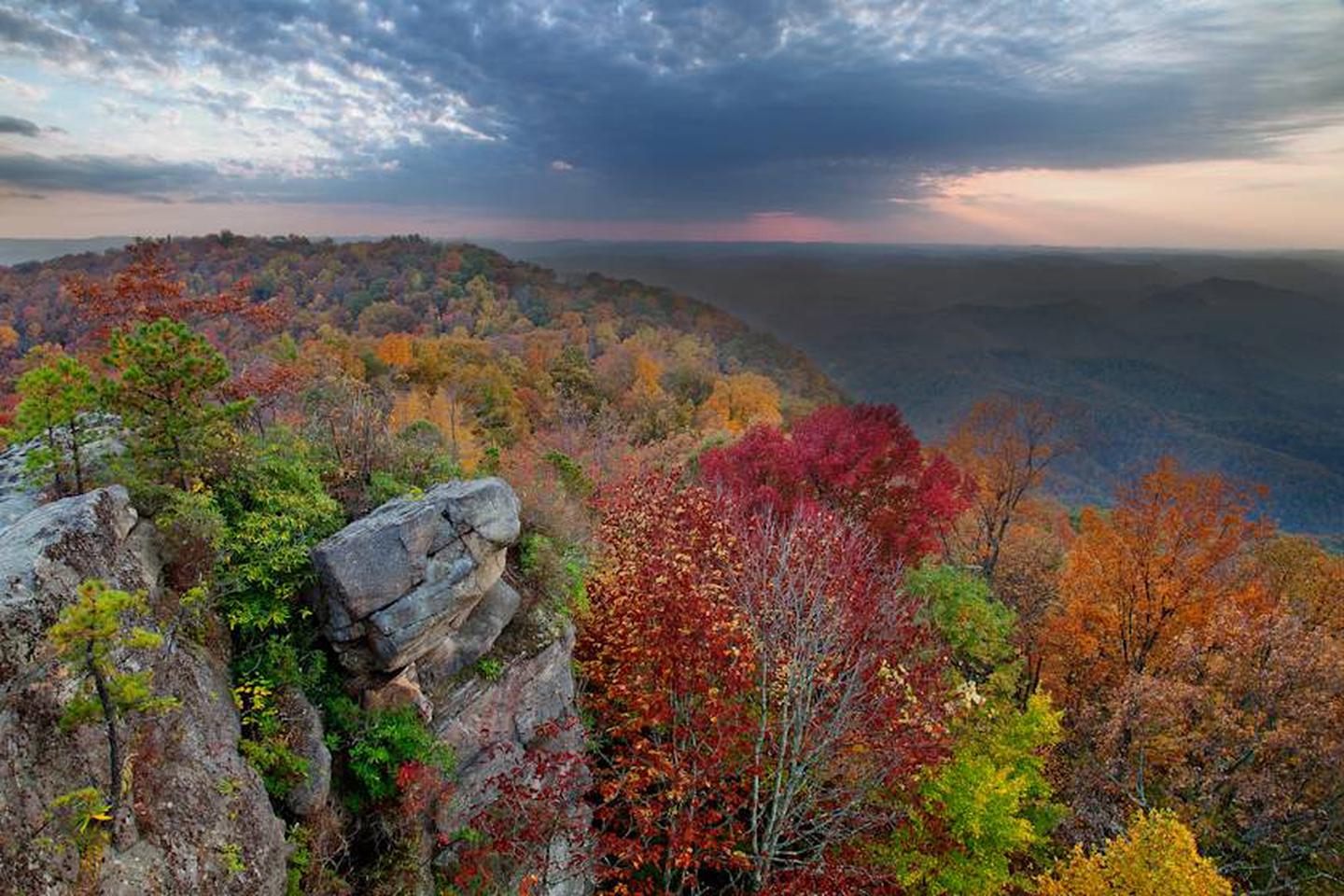
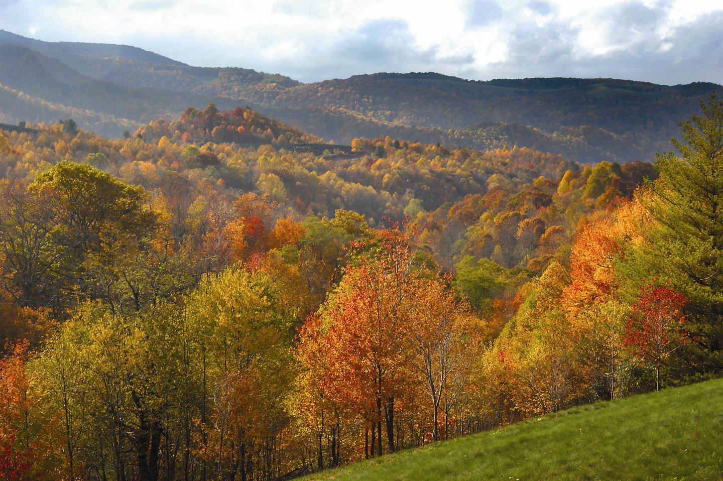
George Washington & Jefferson National Forest


The George Washington and Jefferson National Forests afford virtually every type of outdoor recreation activity you can imagine. Hiking, mountain biking, camping, and fishing are the most popular activities; but don’t forget bird watching, horseback riding, photography, orienteering, and cross-country skiing. Or just spend a lazy day sunning yourself on a beach or warm rock. If you have questions or need suggestions for places to explore, just ask us. We’re here to help make your visit an enjoyable one!

RecAreaDirections
Open with Google Map
Misc
| Stay Limit | |
| Reservable | false |
| Keywords | |
| Map Link | |
| Contact Phone | |
| Contact Email |
Permits info
Facilities
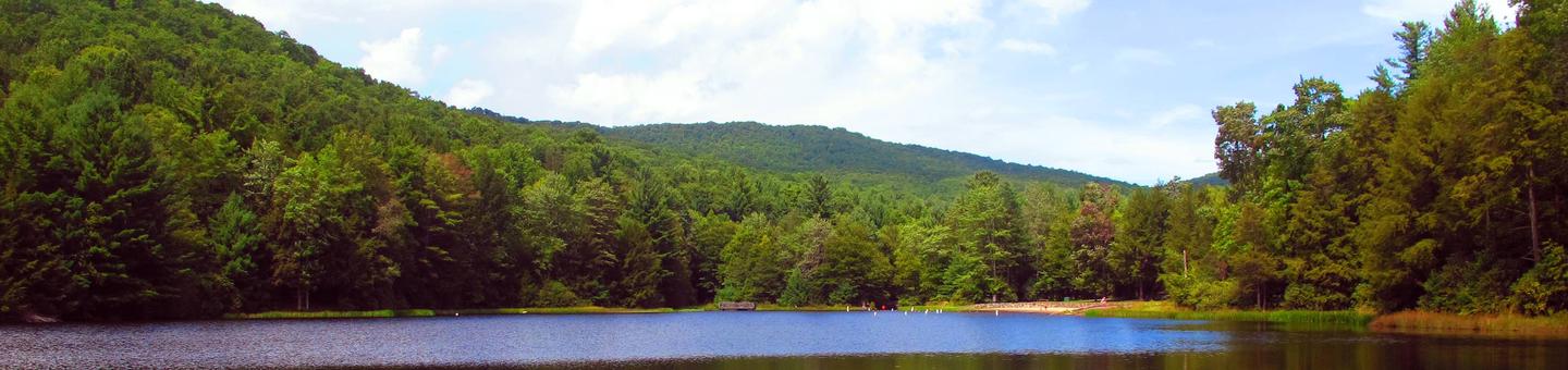
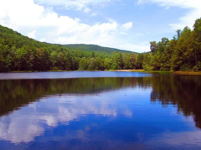
Fenwick Mines Pavilion Campground
List of CampsitesOverview
With ample parking, plenty of picnic tables and three barbcue grills, the Fenwick Mines Pavilion is a great option to host your next outdoor get togther. The pavilion is part of the larger Fenwick Mines Day-Use Area which includes one-mile of trail, picnic areas, and small fishing pond.
Recreation
- Access to the overlook on Bald Mountain and access to the gated Mill Creek Road, a popular 'trail' by mountain bikers and horses (closed to motor vehicles).
- Horseshoe pits
- Fishing pond
- 3/4 mile long Wetlands Trail and 1/4 mile long Nature Trail
Facilities
- Vault Toilets
- Picnic Tables
- Three large barbecue grills
- Horseshoe Pits
Natural Features
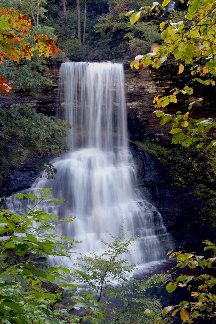
Located at the base of Bald Mountain and adjacent to Mill Creek in Craig County, Fenwick is surrounded by natural beauty that invites further exploration. A one-mile stroll through the forest and large wetlands area will take you to the falls at Fenwick, a picturesque, small multi-tiered waterfall.
Bark Camp Campground
List of CampsitesOverview
This location is available on a first-come, first-served basis only. Visitors are required to physically arrive at the campground to purchase and claim a site. Once on-site, you may be able to pay for your campsite(s) by scanning a QR code using the Recreation.gov mobile app, and the Scan and Pay feature.
If this option is available, you will need to first download the free Recreation.gov mobile app https://www.recreation.gov/mobile-app prior to your arrival as some remote areas have limited or no cellular service.
Blowing Springs Campground
List of CampsitesOverview
This location is available on a first-come, first-served basis only. Visitors are required to physically arrive at the campground to purchase and claim a site. Once on-site, you may be able to pay for your campsite(s) by scanning a QR code using the Recreation.gov mobile app, and the Scan and Pay feature.
If this option is available, you will need to first download the free Recreation.gov mobile app https://www.recreation.gov/mobile-app prior to your arrival as some remote areas have limited or no cellular service.
Brandywine Campground Campground
List of CampsitesOverview
This location is available on a first-come, first-served basis only. Visitors are required to physically arrive at the campground to purchase and claim a site. Once on-site, you may be able to pay for your campsite(s) by scanning a QR code using the Recreation.gov mobile app, and the Scan and Pay feature.
If this option is available, you will need to first download the free Recreation.gov mobile app https://www.recreation.gov/mobile-app prior to your arrival as some remote areas have limited or no cellular service.
Camp Roosevelt Campground
List of CampsitesOverview
This location is available on a first-come, first-served basis only. Visitors are required to physically arrive at the campground to purchase and claim a site. Once on-site, you may be able to pay for your campsite(s) by scanning a QR code using the Recreation.gov mobile app, and the Scan and Pay feature.
If this option is available, you will need to first download the free Recreation.gov mobile app https://www.recreation.gov/mobile-app prior to your arrival as some remote areas have limited or no cellular service.
Cane Patch Campground
List of CampsitesOverview
This location is available on a first-come, first-served basis only. Visitors are required to physically arrive at the campground to purchase and claim a site. Once on-site, you may be able to pay for your campsite(s) by scanning a QR code using the Recreation.gov mobile app, and the Scan and Pay feature.
If this option is available, you will need to first download the free Recreation.gov mobile app https://www.recreation.gov/mobile-app prior to your arrival as some remote areas have limited or no cellular service.
Cave Springs (VA) Campground
List of CampsitesOverview
This location is available on a first-come, first-served basis only. Visitors are required to physically arrive at the campground to purchase and claim a site. Once on-site, you may be able to pay for your campsite(s) by scanning a QR code using the Recreation.gov mobile app, and the Scan and Pay feature.
If this option is available, you will need to first download the free Recreation.gov mobile app https://www.recreation.gov/mobile-app prior to your arrival as some remote areas have limited or no cellular service.
Elizabeth Furnace Campground
List of CampsitesOverview
This location is available on a first-come, first-served basis only. Visitors are required to physically arrive at the campground to purchase and claim a site. Once on-site, you may be able to pay for your campsite(s) by scanning a QR code using the Recreation.gov mobile app, and the Scan and Pay feature.
If this option is available, you will need to first download the free Recreation.gov mobile app https://www.recreation.gov/mobile-app prior to your arrival as some remote areas have limited or no cellular service.
Hidden Valley Campground Campground
List of CampsitesOverview
This location is available on a first-come, first-served basis only. Visitors are required to physically arrive at the campground to purchase and claim a site. Once on-site, you may be able to pay for your campsite(s) by scanning a QR code using the Recreation.gov mobile app, and the Scan and Pay feature.
If this option is available, you will need to first download the free Recreation.gov mobile app https://www.recreation.gov/mobile-app prior to your arrival as some remote areas have limited or no cellular service.
High Knob Campground Campground
List of CampsitesOverview
This location is available on a first-come, first-served basis only. Visitors are required to physically arrive at the campground to purchase and claim a site. Once on-site, you may be able to pay for your campsite(s) by scanning a QR code using the Recreation.gov mobile app, and the Scan and Pay feature.
If this option is available, you will need to first download the free Recreation.gov mobile app https://www.recreation.gov/mobile-app prior to your arrival as some remote areas have limited or no cellular service.
Hone Quarry Campground Campground
List of CampsitesOverview
This location is available on a first-come, first-served basis only. Visitors are required to physically arrive at the campground to purchase and claim a site. Once on-site, you may be able to pay for your campsite(s) by scanning a QR code using the Recreation.gov mobile app, and the Scan and Pay feature.
If this option is available, you will need to first download the free Recreation.gov mobile app https://www.recreation.gov/mobile-app prior to your arrival as some remote areas have limited or no cellular service.
Hussy Mountain Horse Camp Campground
List of CampsitesOverview
This location is available on a first-come, first-served basis only. Visitors are required to physically arrive at the campground to purchase and claim a site. Once on-site, you may be able to pay for your campsite(s) by scanning a QR code using the Recreation.gov mobile app, and the Scan and Pay feature.
If this option is available, you will need to first download the free Recreation.gov mobile app https://www.recreation.gov/mobile-app prior to your arrival as some remote areas have limited or no cellular service.
Little Fort Campground
List of CampsitesOverview
This location is available on a first-come, first-served basis only. Visitors are required to physically arrive at the campground to purchase and claim a site. Once on-site, you may be able to pay for your campsite(s) by scanning a QR code using the Recreation.gov mobile app, and the Scan and Pay feature.
If this option is available, you will need to first download the free Recreation.gov mobile app https://www.recreation.gov/mobile-app prior to your arrival as some remote areas have limited or no cellular service.
North Creek Campground
List of CampsitesOverview
This location is available on a first-come, first-served basis only. Visitors are required to physically arrive at the campground to purchase and claim a site. Once on-site, you may be able to pay for your campsite(s) by scanning a QR code using the Recreation.gov mobile app, and the Scan and Pay feature.
If this option is available, you will need to first download the free Recreation.gov mobile app https://www.recreation.gov/mobile-app prior to your arrival as some remote areas have limited or no cellular service.
Todd Lake Campground Campground
List of CampsitesOverview
This location is available on a first-come, first-served basis only. Visitors are required to physically arrive at the campground to purchase and claim a site. Once on-site, you may be able to pay for your campsite(s) by scanning a QR code using the Recreation.gov mobile app, and the Scan and Pay feature.
If this option is available, you will need to first download the free Recreation.gov mobile app https://www.recreation.gov/mobile-app prior to your arrival as some remote areas have limited or no cellular service.
Wolf Gap Campground
List of CampsitesOverview
This location is available on a first-come, first-served basis only. Visitors are required to physically arrive at the campground to purchase and claim a site. Once on-site, you may be able to pay for your campsite(s) by scanning a QR code using the Recreation.gov mobile app, and the Scan and Pay feature.
If this option is available, you will need to first download the free Recreation.gov mobile app https://www.recreation.gov/mobile-app prior to your arrival as some remote areas have limited or no cellular service.
BOLEY FIELD GROUP CAMPGROUND Campground
List of CampsitesOverview
Boley Field Group Campground provides old-fashioned, rustic group camping for those that require few amenities. The large open field is great for groups that wish to picnic and tent camp together.Recreation
Poverty Creek is adjacent to the picnic area where visitors can enjoy splashing in its cool waters. Poverty Creek is also stocked with trout, providing good fishing opportunites for anglers. Hikers and mountain bikers can easily access the 17-mile Poverty Creek Trail System from the site.Facilities
Boley Field is available for groups of 50 or less. The field has an entrance gate and contains a group fire ring, picnic tables, standing grill and vault toilet. There is no potable water, no hookups and no trash collection. Please pack out everything you bring!Natural Features
The campground is located at the base of Brush Mountain in a narrow valley along Poverty Creek. The surrounding forest provides shade. The road to the camping area is unpaved and vehicles towing a trailer will hit the ground at the creek crossing.Nearby Attractions
Boley Field is located 20 minutes from Blacksburg, VA, home of the Virginia Tech Hokies. The New River is minutes away which offers a 'big' river experience.CALDWELL FIELDS GROUP CAMPGROUND Campground
List of CampsitesOverview
Caldwell Fields Group Campground is actually two separate fields adjacent to each other. George and Milton, each provide group camping and can be reserved together or separately. They are great for groups who prefer old-fashioned, rustic camping who require few amenities.Recreation
Craig Creek meanders along the edge of the fields where visitors can enjoy splashing and relaxing in its cool waters. The creek is also stocked with trout, providing good fishing opportunities for visitors.Facilities
Caldwell Fields provides two fields that may be rented separately or together. Each field can accommodate a group of 50 or less people with space for up to 20 vehicles. Groups may choose to rent them together accommodating a group of up to 100 people and 40 vehicles total. Each field has an entrance gate, and they share a vault toilet. There is no potable water, no hookups and no trash collection. State Highway 621 to Caldwell Fields is unpaved.Natural Features
Located in a narrow valley and flanked by National Forest lands, the two large grassy fields are bordered by large shade trees.Nearby Attractions
Caldwell Fields is located 20 minutes from Blacksburg, VA, home of the Virginia Tech Hokies.MORRIS HILL CAMPGROUND Campground
List of CampsitesOverview
Morris Hill is a peaceful, rustic campground for groups of family and friends. The family campground is a family-friendly destination perched on a ridge above Lake Moomaw. Kids can have fun at the playground while older generations sit back and relax in the shade. The group sites accommodate up the 25 guests with space for up to eight tents. Campers can enjoy the wonders of camping with simple pleasures like s'mores on the campfire, berry picking in the woods, and watching for waterfowl and wildlife like deer. The convenient location near Lake Moomaw and sandy swim beaches, a fishing pier, boat ramp, and hiking and biking trails makes Morris Hill a popular spot.Recreation
An inviting swimming beach at Coles Point attracts many visitors. About less than a mile from the campground is a fishing pier where anglers seek brown and rainbow trout, bass and crappie. Back Creek is also nice for trout fishing. Hikers enjoy the Morris Hill Bike Trail and Fortney Loop Trail.Facilities
Family Campground: Most sites will fit any size RV. Campsite amenities include flush toilets, hot showers, a playground and drinking water. Group Sites: There is no water or electricity. Two fully accessible vault toilets, picnic tables and a group grill are on each group site. Coles Point Boat Ramp, the nearest boat ramp to Morris, is less than two miles away.Natural Features
The campground sits on a ridge overlooking Lake Moomaw. It is about a half-mile from the south end of the lake. Lake Moomaw, which flows from the Jackson River, is a cold-water 2,530-acre lake with an inviting swimming beach.Morris Hill is part of the George Washington and Jefferson National Forests which spans across Virginia and parts of West Virginia and Kentucky. These forests protect 40 species of trees that are mostly Appalachian hardwood and mixed pine-hardwood forests, 60 species of mammals and 200 species of birds.
Nearby Attractions
Head downstream of the Jackson River for fly fishing, canoeing, rafting and kayaking. A half hour east of the lake is Hot Springs, Virginia, a quaint village known as a rural resort town.Charges & Cancellations
Due to Covid-19 restrictions group camping will not be open this season. We apologize for any inconvenience. Please visit www.cdc.gov for the latest information on the virus.
Trout Pond Recreation Area Campground
List of CampsitesOverview
Trout Pond Recreation Area boasts two bodies of water, Rock Cliff Lake and Trout Pond. Relax on a sandy mountain beach or fish for stocked trout while relaxing along the cool waters of Rock Cliff Lake.Trout Pond, home to native Brook trout, is the only natural lake in West Virginia. A designated swimming area, easy lakeside trails, and a children's playground make this a perfect family destination.
Recreation
A trail surrounding the entire lake provides bank fishing access at Rock Cliff Lake. All types of boating from motor to sailboats are welcome.Hike the Trout Pond Loop trail, an easy 4-mile excursion, with an optional 2-mile side route, to an overlook of Rockcliff Lake. For a more challenging hike, a connecting trail provides a steep climb up Long and Devil's Hole Mountains.
Facilities
Campsites come with a campfire ring and picnic table, and some of have electric hookups. Hot showers and flush toilets are an easy walk away from each site.The day-use area includes a white-sand swim beach, boat ramp, showers, playground and 30 picnic sites.
Natural Features
Rock Cliff Lake is a 17-acre man-made lake with a maximum depth of 36 feet and an average depth of 12 feet. Trout Pond, the naturally formed lake, was created by a sinkhole that filled with mountain stream water and run-off from Long Mountain.Charges & Cancellations
group shelter nonelectric 1-50 people $65, 51-100 people $100, standard non electric is $19.00 per nightGRINDSTONE Campground
List of CampsitesOverview
Grindstone Campground is tucked in the Fairwood Valley among pastures and wooded hillsides. The surrounding Mount Rogers National Recreation Area provides endless opportunities for fun and relaxation in the nature setting. The Campground will be closed until further notice due to facility repair needs. Opossum Loop will be open for tent campers. There will be no available water. No Dump Station available.
Recreation
The area offers excellent hiking, mountain biking, horseback riding and hunting. Recommended hiking trails include the Mount Rogers Trail at 7.5 miles and the Whispering Waters Nature Trail at 0.6 miles.Several streams pass by just beyond the campground, with trout fishing available in abundance.
The campground boasts a water play area in the creek, an amphitheater, a playground and volleyball courts to entertain families.
Facilities
All sites have a fire ring with a cooking grate, lantern post, picnic table, and tent pad. Domestic pets are allowed as long as they are attended and kept on a leash no longer than six feet. Standard electric sites have 30 amp service and a water hook-up. PLEASE NOTE ALL CAMPSITES IN COTTONTAIL AND GROUNDHOG DEN WILL BE CLOSED UNTIL FURTHER NOTICE. NO AVAILABLE WATER IN OPOSSUM, COTTONTAIL, AND GROUNDHOG DEN LOOPS.
Natural Features
At 3,800 feet, Grindstone is surrounded by mixed hardwoods, hemlock and rhododendrons. The Mount Rogers National Recreation Area spans 200,000 acres of National Forest, with four wildlife-rich wilderness areas.Nearby Attractions
The Mount Rogers Scenic Byway, which traverses more than 50 miles with views of forestland and open rural countryside, is accessible nearby.BEARTREE Campground
List of CampsitesOverview
Beartree offers a relaxing, family-friendly atmosphere and a variety of recreational activities. Located in the Mount Rogers National Recreation Area, the campground boasts a sprawling layout with both group and individual campsites. A small creek flows through the campground, offering a refreshing spot to wade and fish.
Beartree Lake is also located within the recreation area, providing an ideal spot for fishing.
Recreation
The campground offers a 14-acre lake with two fishing piers. Smallmouth bass, sunfish, rainbow and brown trout are all possible catches.
Self-propelled or electric trolling-motor boats only.
State fishing and boating regulations and licensing requirements apply.
The Beartree Lake Trail, which circles the lake, is excellent for hiking. Half of the trail is paved for an easier walk.
Facilities
Tent and RV campers are welcome. Drinking water is provided. A dump station (no water) is located on the left side of the road before the contact station as you enter the campground. Each site has a grill and picnic table, and most are secluded from other sites. Group sites can accommodate up to 24 guests.
Natural Features
The campground is located in diverse vegetation, and Beartree Lake is surrounded by dense trees that meet the shoreline.The Mount Rogers Scenic Byway passes near the campground, highlighting the impressive valleys, mountains, forests and rural countrysides of western Virginia.
Nearby Attractions
Hike the Appalachian Trail, which extends more than 2,175 miles throughout the Appalachian Mountains across 14 states. The trail was designated as the first National Scenic Trail. The Virginia Creeper Trail, Hungry Mother State Park and Grayson Highlands State Park are nearby.
contact_info
For facility specific information, please call (800) 628-7202.SHERANDO LAKE GROUP CAMP Campground
List of CampsitesOverview
Sherando Lake Group Camp is a part of the Sherando Lake Recreation Area and is popular with family groups, Boy and Girl Scouts, church groups and other local organizations. The recreation area is situated in the Blue Ridge Mountains and is known locally as the jewel of the Blue Ridge Mountains, where visitors enjoy hiking, fishing, swimming and relaxing.Recreation
The 25 acre Lower Lake offers opportunities for swimming in a designated area with a sand beach, accessible ramp to the water's edge, and a beach bathhouse with changing and shower facilities. Fishing and boating are also available outside the designated swimming area in the lake. Fishing is in stocked waters during the spring and fall seasons. Visitors will need to have the appropriate Virginia fishing license, National Forest stamp and trout stamp. Boats with gasoline motors are not permitted on the lower lake - electric troll motors, canoes, kayaks, or similar boats only. A hand-carry ramp is available for access to the lake adjacent to the parking area. Fishing only is available at the 7 acre Upper Lake. This lake is also stocked during the spring and fall seasons and the appropriate licenses are required. Boats are allowed, but there is no launch access - hand carry only. Parking is available at a small area below the group camp area and a walking trail will lead you to the lake. Swimming is not allowed in the upper lake. Hiking trails surround the area offering everything from a short walk around the lake on the Lakeside and Cliff Trails to a day hike up the mountain on the White Rock Gap Trail and the Blue Ridge Parkway. For the more adventurous hiker, more challenging day hikes and backpacking trips are available by heading up the Blue Loop Trail to the Torry Ridge Trail to Bald Mountain and beyond.Facilities
The five tent-only group campsites are located around the outside of the looping road. Each site can accommodate a maximum of 15 guests, or a large group can reserve all 5 sites to fit no more than 75 guests. Each site is delineated with fencing and is equipped with picnic tables, a grill, lantern posts, and a serving table. A bathhouse with flush toilets and showers is located at the upper end of the loop and a vault toilet is located at the lower end of the loop. The bathhouse was replaced during the 2019 season. Drinking water is available at each site. Food storage lockers are currently not available, but all food must be secured in a locked vehicle. Violators are subject to a fine.
Natural Features
The group camp is located at the upper end of the Sherando Lake Recreation Area near the 7 acre upper lake. The group campsites are located around the outer portion of the loop with a large grass field on the interior of the loop for activities and games. The open grassy field provides an excellent opportunity for night time star gazing.Nearby Attractions
There are opportunities for gas, groceries, and firewood at convenience stores and local vendors along the state road to Sherando Lake. Ice can be purchased at the Sherando Lake Visitor Center during operating hours, which vary seasonally. Additional supplies can be obtained in Stuarts Draft, about a 15 minute drive away. The Blue Ridge Parkway with its scenic overlooks and ridgetop views is a short 3 mile drive up State Route 664 from the Sherando Lake entrance. The Wintergreen Resort offers a golf course and ski area within 10 miles of Sherando Lake.CAVE MOUNTAIN LAKE GROUP CAMP Campground
List of CampsitesOverview
Cave Mountain Lake Group Camp is nestled in the Blue Ridge Mountains of Virginia, and welcomes visitors to enjoy the rustic beauty and peacefulness of the area. Easy access from the interstate and close proximity to historic Lexington and Natural Bridge State Park make Cave Mountain Lake an ideal destination. Cave Mountain Lake covers seven acres and was built in the late 1930's by the Civilian Conservation Corps, using existing natural rock buttresses to form the 35-foot dam. A grassy field extends from the lake's sandy beach to forested hills that paint a scenic backdrop.
Recreation
The 7 acre lake offers opportunities for swimming in a designated area which includes a sand beach. Fishing for youth only (ages 15 and under) is open from April 1st through June 15th, then fishing is open to anglers of all ages with a valid Virginia fishing license for the remainder of the season. There are several piers around the lake for better fishing access. A number of opportunities for photography, birding, and wildlife viewing are available along the trails and water's edge. Hiking trails surround the area, offering everything from a short walk around the lake to an all-day hike along the nearby ridges. The Panther Knob Trail starts beside the group picnic shelter and skirts the edge of the lake to the dam. Visitors may also enjoy a day hike or backpacking trip on the Appalachian National Scenic Trail, the James River Face Wilderness, or the Thunder Ridge Wilderness.Facilities
The group camp area allows tent-camping only and can accommodate up to 30 guests. Facilities include six picnic tables which can be moved around within the group area, two fire rings with grills, one double pedestal grill, lantern posts, serving tables, a group campfire circle and a drinking water spigot. Flush toilets are across the road behind the workcenter building and showers are available at the beach bathhouse. Food storage lockers are not currently available, so all food must be secured in a locked vehicle. Violators are subject to a fine.Natural Features
Cave Mountain Lake covers seven acres and was built in the late 1930's by the Civilian Conservation Corps, using existing natural rock buttresses to form the 35-foot dam. A grassy field extends from the lake's sandy beach to forested hills that paint a scenic backdrop.contact_info
This location is unstaffed. To speak with our main office for general information, please call: (540) 291-2188.Nearby Attractions
Lexington, Virginia, just 20 minutes away, is home to several historic sites including the Stonewall Jackson House, George C. Marshall Museum, and the Virgnia Military Institute Museum. It's a charming town with horse drawn carriage rides through the streets. Ice and other sundries can be found at small stores along State Route 759 as you drive to Cave Mountain Lake Recreation Area. Natural Bridge State Park is a short 8 mile drive away and offers visitors views of the 215 foot tall Natural Bridge and limestone gorge, 6 miles of hiking trails, a Monacan Indian village, and the 30 foot cascade of Lace Falls.HOPPER CREEK GROUP CAMP Campground
List of CampsitesOverview
Hopper Creek Group Camp offers a rustic atmosphere under the trees for group camping. Nestled in the Blue Ridge Mountains, the area welcomes visitors to enjoy the natural beauty and relaxing atmosphere.Recreation
A mowed, grassy area is available for games and organized activities. Hiking trails surround the area offering everything from short walks in and around Cave Mountain Lake to a full day hike along the nearby ridges. Backpacking opportunities are also available on the nearby Appalachian National Scenic Trail, in the James River Face Wilderness or in the Thunder Ridge Wilderness.Facilities
The group camp can accommodate up to 50 people. It is designated for tent camping only, and tent pads are provided. The site is equipped with 12 picnic tables, a pedestal double grill, a large campfire circle and a vault toilet. Drinking water is not provided; campers must bring their own supply. Showers are available at nearby Cave Mountain Lake Recreation Area at the beach bathhouse. The day use fee for Cave Mountain Lake would be applicable.Natural Features
A small stream gurgles past the camping area flowing downstream into Hopper Creek on its way to the James River. The campground sits at an approximate elevation of 1,100 feet at the base of Thunder Ridge.Nearby Attractions
Hopper Creek is 3 miles from Cave Mountain Lake, which offers a day use area with sandy beach, designated swimming area and covered picnic shelter. Natural Bridge State Park is within an 8 mile drive and offers visitors views of the 215 foot tall Natural Bridge and limestone gorge, 6 miles of hiking trails, a Monacan Indian village and the 30 foot cascades of Lace Falls. Canoeing, kayaking and fishing are available in the nearby James River.ELIZABETH FURNACE GROUP CAMP Campground
List of CampsitesOverview
Elizabeth Furnace Recreation Area offers forested trails, campsites and open grassy picnic areas along the tranquil Passage Creek. Enjoy hiking the Pig Iron and Charcoal trail and learn how iron was historically mined and smelted. Spend the day fishing from a stocked trout stream, grilling out at a picnic spot, or taking a stroll across the swinging bridge to view the historic cabin.
Recreation
Enjoy hiking the Pig Iron and Charcoal Trail to learn how iron was made in the area. Another great hike heads up to Buzzard Rock.Passage Creek is seasonally stocked with trout to keep anglers entertained.
Facilities
Hand pump available year round in the family campground. No water at group campground.
Vault toilets available year-round; Flush toilets and warm water showers: late May-September
Natural Features
The charming group campground sits in the Shenandoah Valley along Passage Creek, a tributary of the North Fork Shenandoah River. The area is part of the George Washington and Jefferson National Forests which spans across Virginia and parts of West Virginia and Kentucky. These forests protect 40 species of trees that are mostly Appalachian hardwood and mixed pine-hardwood forests, 60 species of mammals and 200 species of birds.COLES POINT Campground
List of CampsitesOverview
Coles Point Picnic Shelters are tucked in a small opening surrounded by a hardwood forest. Opportunities abound for hiking, photography, nature study, birding and viewing wildlife. Best of all, Coles Point is perched along Moomaw Lake, providing convenient access to boating, fishing, swimming and relaxing on the beach.Recreation
An inviting swimming beach within the recreation area lures crowds, and the picnic area has an open field for games like Frisbee and soccer.The park offers boating and fishing for large and smallmouth bass, brown trout, bluegill, crappie, shad, catfish, sunfish and chain pickerel. Two fishing docks, two boat ramps and a swimming beach with a bathhouse are located on-site. Back Creek is nearby, also a nice stream for trout fishing.
The 1-mile Morris Hill Bike Trail is popular among hikers and bikers. The 3-mile Fortney Loop Trail is open to hiking along a path with several switchbacks.
Facilities
Each shelter can accommodate up to 50 people and 20 vehicles. Eight picnic tables sit on a concrete pad, and several additional tables are scattered around the shelter. Each shelter is also equipped with two large barbecue grills, one electrical outlet, drinking water and flush toilets.Natural Features
The shelters are situated on a wooded peninsula on the south end of Lake Moomaw in Alleghany County. The manmade lake, at 2,530 acres, sits on the Jackson River and has 43 miles of wooded shoreline.Coles Point is part of the George Washington and Jefferson National Forests which span across Virginia and parts of West Virginia and Kentucky. These forests protect 40 species within mostly Appalachian hardwood and mixed pine-hardwood forests, 60 species of mammals and 200 species of birds.
Nearby Attractions
Head downstream on the Jackson River for fly-fishing, canoeing, rafting and kayaking. A half-hour east of the lake is Hot Springs, Virginia, a quaint and small rural resort town.The nearest groceries and gas are located in Covington, Virginia about 30 minutes from the lake. A pay phone is located at the nearby Morris Hill Campground.
SHERANDO LAKE GROUP PICNIC SHELTER Campground
List of CampsitesOverview
Sherando Lake Group Picnic Shelter, also known as the Williams Branch Group Picnic Shelter is a part of the Sherando Lake Recreation Area. The recreation area is often referred to as the jewel of the Blue Ridge Mountains and is a very popular destination where families enjoy picnicking in the shade and relaxing on the sandy beach.Recreation
The 25 acre Lower Lake offers opportunities for swimming in a designated areas with a sand beach, accessible ramp to the water's edge and a beach bathhouse with changing and shower facilities. Fishing and boating are also available outside the designated swimming area in the lake. Fishing is in stocked trout waters during the spring and fall seasons. Visitors will need to have the appropriate Virginia Fishing license, National Forest stamp and trout stamp. Boats with gasoline motors are not permitted on the lower lake - electric troll motors, canoes, kayaks, or similar boats only. A hand-carry ramp is available for access to the lake adjacent to the parking area. Fishing only is available at the 7 acre Upper Lake. This lake is also stocked during the spring and fall seasons and the appropriate licenses are required. Boats are allowed, but there is no launch access - hand carry only. Parking is available at a small area below the group camp area and a walking trail will lead you to the lake. Swimming is not allowed in the upper lake. Hiking trails surround the area offering everything from a short walk around the lake on the Lakeside and Cliff Trails to a day hike up the mountain on the White Rock Trail and the Blue Ridge Parkway. For the more adventurous hiker, more challenging day hikes and backpacking trips are available by heading up the Blue Loop Trail to the Torry Ridge Trail to Bald Mountain and beyond. Bald Mountain used to be the location of a fire lookout tower.Facilities
The Group Picnic Shelter (also called Williams Branch Picnic Shelter) was constructed by the Civilian Conservation Corps (CCC) in 1936. Several tables and benches were also constructed by the CCC and are still in use under the shelter. The area can accommondate up to 25 people, to meet the Governor's COVID restrictions. Amenities at the site include a covered shelter with 4 picnic tables, a double pedestal grill, a fireplace under the shelter, additional picnic tables surrounding the shelter, and a bathroom with flush toilets nearby. The shelter can be accessed by vehicle using a short service road and there is parking for 40 cars immediately adjacent to the shelter. The day use area closes at 9 pm or dusk, whichever comes first and the main gate at the state road closes at 10 pm. Visitors not staying overnight in the campground need to exit before the main gate closes at 10 pm.
Natural Features
The group picnic shelter is located a short walking distance from the 25 acre lower lake with a sand beach, shaded grassy area and beach bathhouse. The lake is spring and stream-fed by Back Creek, so the water stays refreshingly cool all summer long.Nearby Attractions
There are opportunities for gas, groceries, and firewood at convenience stores and local vendors along the state road to Sherando Lake. Ice can be purchased at the Sherando Lake Visitor Center during operating hours. Additional supplies can be obtained in Stuarts Draft, about a 15 minute drive away. The Blue Ridge Pakrway with its scenic overlooks and ridgetop views is a short 3 mile drive up State Route 664 from the Sherando Lake entrance. The Wintergreen Resort offers a golf course and ski area within 10 miles of Sherando Lake.CAVE MOUNTAIN LAKE GROUP PICNIC SHELTER Campground
List of CampsitesOverview
Cave Mountain Lake Group Picnic Shelter is nestled in the Blue Ridge Mountains of Virginia, and welcomes visitors to enjoy the rustic beauty and peacefulness of the area. Easy access from the interstate and close proximity to historic Lexington and Natural Bridge State Park make Cave Mountain Lake an ideal destination.Recreation
The 7 acre lake offers opportunities for swimming in a designated area which includes a sand beach. Fishing for youth only (ages 15 and under) is open April 1st through June 15th, then fishing is open to anglers of all ages with a valid Virginia fishing license for the remainder of the season. There are several piers around the lake for better fishing access. A number of opportunities for photography, birding and wildlife viewing are available along the trails and water's edge. Hiking trails surround the area, offering everything from a short walk around the lake to an all-day hike along the nearby ridges. The Panther Knob Trail starts beside the group picnic shelter and skirts the edge of the lake to the dam. Visitors may also enjoy a day hike or backpacking trip on the Appalachian National Scenic Trail, the James River Face Wilderness or the Thunder Ridge Wilderness.Facilities
The picnic shelter is a historic structure that does not support accessibility standards. Parking is available in the day-use parking area and the shelter is reached via a foot bridge and along a gravel path. The shelter can accommodate up to 50 people. Amenities include electricity for lights and small appliances, a fireplace, eight picnic tables under the shelter with more nearby, a double pedestal grill, trash cans and a drinking fountain with a spigot. Flush toilets and showers are available at the beach bathhouse which include showers and changing areas. The beach area is within walking distance of the group picnic shelter. The day use area, including the picnic shelter, closes at 9 pm or dark, whichever comes first. The main gate on State Route 781 closes at 10 pm and visitors not camping need to exit the area before the gate closes. Guests attending events scheduled for the group picnic shelter are still responsible for the appropriate day use fee.Natural Features
Cave Mountain Lake covers seven acres and was built in the late 1930s by the Civilian Conservation Corps, using existing natural rock buttresses to form the 35-foot dam. A grassy field extends from the lake's sandy beach to forested hills that paint a scenic backdrop.Nearby Attractions
Lexington, Virginia, just 20 minutes away, is home to several historic sites including the Stonewall Jackson House, George C. Marshall Museum and the Virignia Military Institute Museum. It's a charming town with horse drawn carriage rides through the streets. Ice and other sundries can be found at small stores along State Route 759. Natural Bridge State Park is a short 8 mile drive and offers visitors views of a 215 foot tall Natural Bridge and limestone gorge, 6 miles of hiking trails, a Monacan Indian village, and the 30 foot cascade of Lace Falls.contact_info
This location is unstaffed. To speak with our main office for general information, please call: (540) 291-2188.HURRICANE CAMPGROUND Campground
List of CampsitesOverview
Hurricane Campground is one of the best kept secrets in southwest Virginia. Located along a rushing mountain stream under the shade of hemlock and rhododendron, this campground offers a peaceful setting for those looking to relax as well as visitors looking for outdoor adventure.From the campsite, hikers can access many trails including the Appalachian Trail. This well-known trail extends more than 2,189 miles throughout the Appalachian Mountains across 14 states. It is a protected greenway and owns the title as the first National Scenic Trail.
Recreation
Visitors frequently explore the Hurricane Knob Trail. The loop trail, at 1.1 miles, parallels Hurricane Creek for about half a mile, crosses two wooden bridges and ascends to the picturesque Hurricane Knob. The creeks are stocked with trout for a relaxing day of fishing.Facilities
Hurricane has drinking water, flush toilets, hot showers and a playing field. Large RVs are not recommended. Each site comes with a lantern pole, picnic table and campfire ring.Natural Features
The campground is perched along Hurricane Branch and Comers Creek, among colorful rhododendron. Several groomed, grassy fields unfold at the campground, but the campsites are nicely shaded by mixed woods of oak and hemlock. Hurricane Knob is nearby with an elevation from 2800 to 3050 feet.Nearby Attractions
Hurricane and Comers creeks run through the campground and surrounding areas for wading and trout fishing. Additional fishing options and excellent hunting opportunities are available near the campground. State fishing and hunting regulations and licensing requirements apply. Hurricane Knob Nature Trail offers a brisk 1-mile loop hike and there is easy access to the Appalachian Trail within ½ mile. The entire campground has a relaxing, rustic atmosphere and an open field allows for games and family fun.
CAVE MOUNTAIN LAKE FAMILY CAMP Campground
List of CampsitesOverview
Cave Mountain Lake Family Camp is nestled in the Blue Ridge Mountains of Virginia, and welcomes visitors to enjoy the rustic and peaceful getaway. Easy access from the interstate and close proximity to historic Lexington and the Natural Bridge State Park make Cave Mountain Lake an ideal destination.Recreation
The 7 acre lake offers opportunities for swimming in a designated area which includes a sand beach. Fishing for youth only (ages 15 and under) is open from April 1st through June 15th, then fishing is open to anglers of all ages with a valid Virginia fishing license, trout stamp and National Forest stamp for the remainder of the season. There are several piers around the lake for better fishing access. A number of opportunities for photography, birding, and wildlife viewing are available along the trails and water's edge. Hiking trails surround the area, offering everything from a short walk around the lake to an all-day hike along the nearby ridges. The Panther Knob Trail starts beside the group picnic shelter and skirts the edge of the lake to the dam. The Wildcat Trail starts above campsites #41-42, climbs the mountain, then loops back to the campground above the volunteer host site in the upper camping loop. Visitors may also enjoy a day hike or backpacking trip on the Appalachian National Scenic Trail, in the James River Face Wilderness, or in the Thunder Ridge Wilderness.Facilities
Cave Mountain Lake offers 41 reservable campsites at this time. Amenities at each campsite include a picnic table, lantern post and campfire ring with grill. Flush toilets and water spigots are located throughout the campground. There is a bathhouse with warm water showers located across the road from Campsite #20. Each campsite can accommodate up to 8 people per site. Campsite #41-42 is considered a double campsite with space to accommodate up to 12 people. All camping requires a reservation prior to arriving. Campsites can be reserved via Recreation.gov or 1-877-444-6777. No first-come, first-serve sites.
Natural Features
Cave Mountain Lake covers seven acres and was built in the late 1930's by the Civilian Conservation Corps, using existing buttresses of natural rock to form a 35-foot dam. A grassy field extends from the lake's sandy beach to forested hills that paint a scenic backdrop.contact_info
This location has limited staffing. Please call (540) 291-2188 for general information.Nearby Attractions
Lexington, Virginia, just 20 minutes away, is home to several historic sites including the Stonewall Jackson House, George C. Marshall Museum and the Virginia Military Institute Museum. It's a charming town with horse drawn carriage rides through the streets. Ice and other sundries can be found at small stores along State Route 759 as you drive to Cave Mountain Lake Recreation Area. Natural Bridge State Park is a short 8 mile drive away and offers visitors views of the 215 foot tall Natural Bridge and limestone gorge, 6 miles of hiking trails, a Monacan Indian Village, and the 30 foot cascade of Lace Falls.OLD VIRGINIA GROUP HORSE CAMP Campground
List of CampsitesOverview
Old Virginia Group Horse Camp provides group equestrian camping just minutes from a large network of horse trails in the Mount Rogers National Recreation Area. Old Virginia is a secluded, picturesque campground that can accommodate up to 25 guests and 25 horses. The picturesque views of the mountains and the trickling sounds of the stream create a relaxing, serene vibe for visitors at the primitive camping site.Recreation
Old Virginia offers easy access to the Virginia Highlands Horse Trail, which connects to the Iron Mountain Trail. From the Iron Mountain Trail, riders can also access the Virginia Creeper Trail to the west or the New River Trail to the east. The Virginia Creeper Trail boasts 33.4 miles of scenery with about 100 trestles and bridges.Facilities
No drinking water is provided. Please bring plenty of water and tools for manure removal. The campground is easily accessed from a paved road and two portable toilets are provided.
Horses may drink from the stream.
Natural Features
The campground sits in the Fairwood Valley along a stream that flows into Fox Creek. The valley is part of the George Washington and Jefferson National Forests in western Virginia. The forests span 1.8 million acres of rugged Appalachians through Virginia and parts of West Virginia and Kentucky.Nearby Attractions
Mount Rogers National Recreation Area high country trails, Virginia Creeper Trail, Grayson Highlands State Park, Hungry Mother State ParkBLUE SPRINGS GAP CABIN Campground
List of CampsitesOverview
Blue Springs Gap Cabin is located high on a mountaintop near Camp, Virginia, giving visitors the feeling of being on top of the world. The space has three comfortable bedrooms, a kitchen and a living room with a large stone fireplace. Electricity and flush toilet add modern comfort to this rustic mountain setting.Accessible hiking and biking trails pass near the cabin and Hale Lake is just 2 miles away, providing combined opportunities for bird watching, hiking, biking, fishing and picnicking.
Recreation
The Mount Rogers National Recreation Area features four Congressionally designated wilderness areas; the Virginia Creeper Trail; the Mount Rogers Scenic Byway; the 5,000 acre Crest Zone, featuring elevations over 4,000 feet, large rock formations and a herd of wild, free-ranging ponies; and last but not least, the highest elevated road in the state of Virginia leading to the summit of Whitetop Mountain.The Blue Springs Trout Fishing stream is just over a mile from the cabin and Hale Lake is about 2 miles away. Hale Lake is popular among anglers who come to these quiet mountainside waters in search of a good day of fishing.
The Hale Lake Trail, 0.58-mile loop trail is an easy hike around that lake, occasionally veering away from the shoreline and into the surrounding hardwood forests. Birders will probably find this site most productive during migration.
In spring, it should be easy to spot several species of warblers and flycatchers. In fall, the lake is likely to invite migrating waterfowl and shorebirds. Wood duck breed in the area and can occasionally be seen on the lake. White-tailed deer and wild turkey roam through the surrounding woodlands, and might be found approaching the lake to quench a thirst.
Facilities
The cabin and grounds can fit a maximum of eight people. The single-story cabin comes with three bedrooms, a kitchen, bathroom and living room. One bedroom has a queen bed, the other has a full sized bunk bed, and the third has a twin bunk bed.
The large stone fireplace provides heat, but there is no other heat source, and no air conditioning either. Electricity is available from April 1 to November 29. Flush toilet is available from April 1-October 31, and a portable toilet is used from November 1 to November 29.
Outside there is a porch with a porch swing, a grill and picnic table. No linens, blankets or pillows are provided, so campers are recommended to bring their own to ensure a comfortable stay. There is a fully stocked kitchen with a refrigerator and microwave available for your use.
Most importantly, there is no water available at the cabin. Visitors must bring plenty of their own for drinking, washing and cooking. Garbage bags, firewood, a flashlight and a first aid kit are also recommended.
Natural Features
Blue Springs Gap is situated in a grassy clearing atop a mountain peak in southwest Virginia. From the cabin's front porch campers have views of the impressive Appalachian peaks and valleys. Beyond the clearing is a dense stand of mixed hardwoods and pines.The cabin is located in the Mount Rogers National Recreation Area, a 200,000-acre stretch of land that includes two lakes, 50 miles of streams and multiple historic sites. During the fall months, visitors are treated to an incredible showing of autumn colors, as the foliage display in the area is known as some of the best in the region.
Nearby Attractions
The nearest access to drinking water is 4 miles east at Comers Rock Campground. The nearest phone is 12 miles in Speedwell, Virginia.STONY FORK CABIN Campground
List of CampsitesOverview
Stony Fork Cabin is a cozy one-bedroom hideaway with most of the comforts of home. Visitors can hike, mountain bike, explore the many nearby creeks, or simply relax on the cabin's private patio.The cabin is located within the Stony Fork Campground along the Big Walker Mountain Scenic Byway. The Appalachian Trail, Seven Sisters Trail, and stocked fishing streams are all within a close proximity, and the site is easily accessed from I-77.
Recreation
The Big Walker Mountain Scenic Byway is an incredible drive for viewing the blooms of rhododendron, azalea and mountain laurel in spring, and fiery red and gold foliage in fall. Scenic overlooks highlights include views of Mount Rogers and the many ridges and valleys.Experienced hikers love the Seven Sisters Trail, which leads from the campground to the top of Little Walker Mountain, then onto the Scenic Byway. The creek offers trout fishing for campers.
Facilities
The 900 square foot log cabin has oak hardwood floors, a kitchen, full bathroom, and a living and dining area. It sleeps up to four guests with two twin beds and a sleeper sofa.
Cabin amenities include a private patio, cookware and utensils, a toaster, oven, refrigerator, microwave and coffee maker. Behind the cabin is a picnic table and campfire ring with grate.
Electricity and drinking water is included, but the cabin does not have air conditioning. Campers are asked to bring a flashlight, pillows, sheets, blankets, food, trash bags, bath towels, dishwasher detergent, firewood, a first aid kit and charcoal for the grill.
Natural Features
Stony Fork Cabin sits at the foot of Big Walker Mountain at an elevation of 2,400 feet. Its creekside setting provides a peaceful soundtrack of running water. In springtime, wildflowers and rhododendron dot the region with spectacular colors, and fall is reliably scenic with its red and yellow foliage.Nearby Attractions
Located within 10 miles of the cabin, the legendary Appalachian Trail extends for more than 2,175 miles through the Appalachian Mountains across 14 states. It was the first trail to be designated as a National Scenic Trail.
SUNRISE CABIN Campground
List of CampsitesOverview
Visitors at Sunrise Cabin enjoy outstanding views from the front porch and warm, cozy evenings beside the stone fireplace. Sunrise cabin provides visitors with unique opportunity to enjoy the natural features of the George Washington & Jefferson National Forests while still having many of the conveniences of home.The cabin was constructed in 1980 and offers many modern amenities such as electricity, kitchen appliances and showers. The property was acquired in an effort to help preserve the land around the beloved Virginia Highlands Horse Trail in southwest Virginia.
Recreation
Recreation opportunities abound, with easy access to hiking, fishing, biking and canoeing. The cabin is right across from the Virginia Highlands Horse Trail, a 68-mile trail through mountains and valleys of the Appalachians.The New River Trail State Park has been designated an official National Recreation Trail by the U. S. Department of the Interior. It is located less than 5 miles from the cabin and parallels 39 miles of the New River, which is one of the world's oldest rivers and among a handful of rivers flowing north.
In addition to hiking, biking and horseback riding, the park offers opportunities for anglers to fish for just about every major freshwater game fish in the state. While there are no designated swimming locations, tubing, canoeing and kayaking are all popular ways for visitors to get in and enjoy the river.
Facilities
The modern, two-story house can accommodate up to eight people. It has four furnished bedrooms including one full bed and six twin beds, two bathrooms with bathtubs, a living room, dining room, and a fully equipped kitchen. There is a front porch and back patio with a built-in fireplace and picnic table. Limited dishes, pots and pans are included.
Electricity and hot water are provided, but the unit does not have a washer or dryer, air conditioning, a phone or television. Campers are expected to bring their own bed linens, pillows, towels, flashlight, food, dish detergent, a first aid kit and trash bags. For outside enjoyment, visitors can bring lawn furniture, firewood for the fireplace and charcoal for the grill.
This cabin is not professionally cleaned between each renter. Renters are asked to bring basic cleaning and paper products (broom, mop, dust pan provided) and leave the cabin in good order for the next renter.
Natural Features
The cabin features a large grassy lawn that meets a dense stand of pine and hardwoods. At an elevation of 2,500 feet, the front deck provides scenic mountain views of the Blue Ridge Highlands Region.The cabin is located in the Mount Rogers National Recreation Area, a 200,000-acre stretch of land with two lakes, 50 miles of streams and multiple historic sites.
Nearby Attractions
New River Trail State Park, Virginia Highlands Horse TrailBOLAR MOUNTAIN RECREATION AREA Campground
List of CampsitesOverview
Bolar Mountain Recreation Area is a great destination for visitors looking for a fun getaway on Lake Moomaw. The area provides plenty of outdoor activities, including boating, fishing, camping and hiking. There is little to no cell service, so be ready to disconnect!
Recreation
Boating, canoeing, water skiing and relaxing on the beach are popular activities at the lake. Anglers fish for brown and rainbow trout, bass and crappie. A boat ramp is located at the Bolar Flat Marina, which has a modern dock with boat slips. Bolar Mountain boasts 11 miles of hiking trails that lead to two impressive scenic overlooks: Islands Overlook Spur and Grouse Point Overlook. Looking for a more primitive experience? Hike or boat to Greenwood Point for dispersed camp sites.
Facilities
We have four campgrounds here at Bolar Mountain Recreation area; Sugar Ridge, Campground 1, Campground 2 & Campground 3 respectively. Each campground has "Prime" sites which have a view and/or direct access to the lake, those seeking electric sites will find most of their options at Campground 1 followed by 2 & 3. Potable water taps can be found throughout each camp along with flush toilets and showers. Individual camp sites have a picnic table, lantern post, a fire ring and a Camp Host to answer any questions/concerns you may encounter.
Campers can empty their waste tanks at one of the two dump stations at Campground 1 or Campground 2.
Natural Features
The campground sits on the northern end of Lake Moomaw, a manmade lake covering 2,530 acres along the Jackson River. The lake is held by Gathright Dam, constructed in the 1980's by the Army Corps of Engineers for flood control. The lake's average depth is 80 feet and it has 43 miles of wooded shoreline making it the second largest impoudment in western virginia.
Bolar Mountain is part of the George Washington and Jefferson National Forest which span 1.8 million acres across Virginia and parts of West Virginia and Kentucky. The forest protects 40 tree species within mostly Appalachian hardwood and mixed pine-hardwood forests, 60 species of mammals and 200 species of birds.
Nearby Attractions
Hidden Valley is a short drive from the lake and has ample opportunities for outdoor enthusiast: Hike or ride your horse along the Jackson River, all the way to Poor Farm, cast a line for trout, and stay at the Hidden Valley Campground or even better the historic bed and breakfast. Warm Springs has restaurants, shopping and a Historical Society for Bath County in addition to other typical amenities.
MCCLINTIC POINT Campground
List of CampsitesOverview
Enjoy the easygoing, peaceful vibe of McClintic Point's rustic campground set among scattered trees and open fields. This angler's paradise provides plentiful shoreline fishing and some lakefront campsites.Recreation
Boating, canoeing, water skiing and and fishing are popular activities on the lake. Brown and rainbow trout, bass and crappie are some of the popular species anglers catch. The campground's open spaces are also handy for running around of stretching out on the grass.Facilities
Amenities include vault toilets and seasonal drinking water, which is available April through October. The three group campsites range in capacity from 20 to 35 guests.Natural Features
The campground sits on the northern end of Lake Moomaw. The lake boasts 2,530 surface acres with 43.5 miles of shore line and a maximum depth of 150 feet.Nearby Attractions
Head to the quaint town of Warm Springs for restaurants or to visit the Bath County Historical Society.RACCOON BRANCH CAMPGROUND Campground
List of CampsitesOverview
Raccoon Branch Campground, nestled at the base of Dickey Knob, offers scenic mountain views, hiking trail access from campsites and cool mountain streams. Campers can access Dickey Creek and the Raccoon Branch from the campground. The most notable time to visit is fall, when the trees boast gorgeous fall foliage.With a location just 11 miles from Interstate 81, the beautiful campground is easily reached by drivers heading out from one of the surrounding cities.
Recreation
The beautiful Dickey Knob Trail takes hikers through a Wilderness to the top of Dickey Knob for spectacular views of Sugar Grove and Rye Valley. The creek provides a setting for wading and fishing.Facilities
Every site accommodates RV or tent camping and five campsites have electric hookups. Perks of the campground include flush toilets, drinking water, paved roads and spurs and a dump station. There are no showers. A volunteer host is onsite to welcome visitors and offer advice on the region.
Natural Features
The campground is at an elevation of 2,880 ft., along a large grassy area, surrounded by pines, hardwoods and rhododendrons. Perched in the Appalachian Mountains, Raccoon Branch is part of the Mount Rogers National Recreation Area, a 200,000-acre stretch of designated wilderness areas.Nearby Attractions
Hike the Appalachian Trail, which extends more than 2,175 miles throughout the Appalachian Mountains across 14 states. The trail was designated as the first National Scenic Trail. The Virginia Creeper Trail, Hungry Mother State Park and Grayson Highlands State Park are nearby.STONY FORK CAMPGROUND Campground
List of CampsitesOverview
Stony Fork, tucked in a dense forest setting, is located at the foot of Big Walker Mountain beside the Big Walker Mountain Scenic Byway. The East Fork of Stony Fork Creek winds through the campground, providing a serene setting for trout fishing and water play for visitors at the welcoming campground.The 1 mile Stony Fork Nature Trail takes campers through groves of pine and hardwoods, and the campground loop road makes for a scenic walk, too.
Recreation
The Big Walker Mountain Scenic Byway is an incredible drive for viewing blooms of rhododendron, azalea and mountain laurel in spring, and fiery red and gold foliage in fall. Scenic overlooks highlight views of Mount Rogers and many ridges and valleys. A horseshoe pit at the campground provides hours of fun for families. Experienced hikers love the Seven Sisters Trail, approximately 5 miles, which leads from the campground to the top of Little Walker Mountain, then onto the Scenic Byway.Facilities
Volunteer hosts are on hand to answer questions and make campers feel welcome. Campsites are ideal for both RV and tent camping. Warm showers and flush toilets are available, plus parking aprons are paved. Most sites come with electric hookups.Natural Features
Stony Fork sits in a valley of the Appalachians at a 2,400 foot elevation. Its creekside setting provides a peaceful soundtrack of running water. In springtime, wildflowers and rhododendron dot the region with spectacular colors, and fall is reliably scenic with its red and yellow foliage.Nearby Attractions
Within 10 miles of the campground, hike the popular Appalachian Trail, which extends more than 2,175 miles throughout the Appalachian Mountains across 14 states. It is the first trail designated as a National Scenic Trail. There is an outdoor shooting range a few miles from the campground.
SHERANDO LAKE RECREATION AREA FAMILY CAMPING Campground
List of CampsitesOverview
Sherando Lake Recreation Area's Family Campground provides an ideal camping destination. It is situated in the Blue Ridge Mountains and is known locally as the jewel of the Blue Ridge Mountains, where visitors enjoy hiking, picnicking in the shade, fishing in the lakes, or swimming and relaxing on the sandy beach.Recreation
The 25 acre Lower Lake offers opportunities for swimming in a designated area with a sand beach, accessible ramp to the water's edge, and a beach bathhouse with changing and shower facilities. Fishing and boating are also available outside the designated swimming area of the lake. Fishing is in stocked trout waters during the spring and fall seasons. Visitors will need to have the appropriate Virginia fishing license, National Forest stamp, and trout stamp. Boats with gasoline motors are not permitted on the lower lake - electric troll motors, canoes, kayaks, or similar boats only. A hand-carry ramp is available for access to the lake adjacent to the parking area. Fishing only is available at the 7 acre Upper Lake. This lake is also stocked during the spring and fall seasons and the appropriate licenses are required. Boats are allowed, but there is no launch access - hand carry only. Parking is available at a small area below the group camp area and a walking trail will lead you to the lake. Swimming is not allowed in the upper lake. Hiking trails surround the area offering everything from a short walk around the lake on the Lakeside and Cliff Trails to a day hike up the mountain on the White Rock Trail and the Blue Ridge Parkway. For the more adventurous hiker, more challenging day hikes and backpacking trips are available by heading up the Blue Loop Trail to the Torry Ridge Trail to Bald Mountain and beyond.Facilities
The campground is divided into three loops: Meadow Loop (Loop C) and River Bend Loop (Loop B) have campsites with electric hookups which are suitable for larger camping units and RV's; White Oak Loop (Loop A) has non-electric campsites, suitable for tents and camping units less than 20 feet in length. All camping requires a reservation prior to arriving. Campsites can be reserved via Recreation.gov or 1-877-444-6777. No first-come, first-serve sites.
Each campsite is equipped with a picnic table, serving table, lantern post, and campfire ring with grill. The designated tent pads are covered with a fine brown sandy gravel. Showers, flush toilets and drinking water hydrants are located in each loop. The water hydrants are not threaded for hose hook-ups. Most campsites are equipped with a food storage locker for securing your food due to bear activity. It is mandatory that all food be either stored in a food storage locker or secured in a locked vehicle. Violators are subject to a fine. You are camping in the mountains with unlevel ground. Please be prepared.
A trailer dump station is located along the main road between the entrance station and the road to the lower lake parking. A potable water station with threaded hose (to fill RV tanks) is located within the campground, opposite of the Day-Use parking area near the Williams Branch picnic area bathroom. Both the dump station and fill station are signed.
Natural Features
The campground sits between Lower Sherando Lake and Upper Sherando Lake at an elevation of about 1,800 feet in the shadows of Torry Ridge. The Upper Lake is 7 acres and is fed by the waters of the North Fork of Back Creek. The Lower Lake is 25 acres and is fed by springs, the North Fork of Back Creek, and Williams Branch, so the water stays refreshingly cool all summer long.Nearby Attractions
There are opportunities for gas, groceries, and firewood at convenience stores and local vendors along the state road to Sherando Lake. Ice can be purchased at the Sherando Lake Visitor Center during operating hours, which vary seasonally. Additional supplies can be obtained in Stuarts Draft, about a 15 minute drive away.
The Blue Ridge Parkway, with its scenic overlooks and ridgetop views, is a short 3 mile drive up State Route 664 from the Sherando Lake entrance. The Wintergreen Resort offers a golf course and ski area within 10 miles of Sherando Lake. Cabin rentals are available near Sherando Lake from local private vendors.
Lee Ranger District Facility
Recreational opportunities in the Lee Ranger District.
Glenwood-Pedlar Ranger District Facility
Explore recreational opportunities in the Glenwood-Pedlar Ranger District of the National Forest by activity type below.
Also check out adventures specific to Rockbridge county at our partner's website: Rockbridgeoutdoors.com
Pandapas Pond Day Use Area Facility
Pandapas Pond is a pastoral, 8 acre pond located just outside the town of Blacksburg. It sits on the Eastern Continental Divide and is surrounded by a forest of hardwoods and rhododendron. Visitors will enjoy strolling the one-mile wheelchair accessible trail that encircles the pond. A wooden boardwalk separates the pond from a small wetland area that is abundant with dragonflies, turtles, songbirds, and waterfowl. Horses and bicycles are not permitted on the trail around the pond; however they may use the 17-mile Poverty Creek Trail system that can be accessed from the upper parking lot.
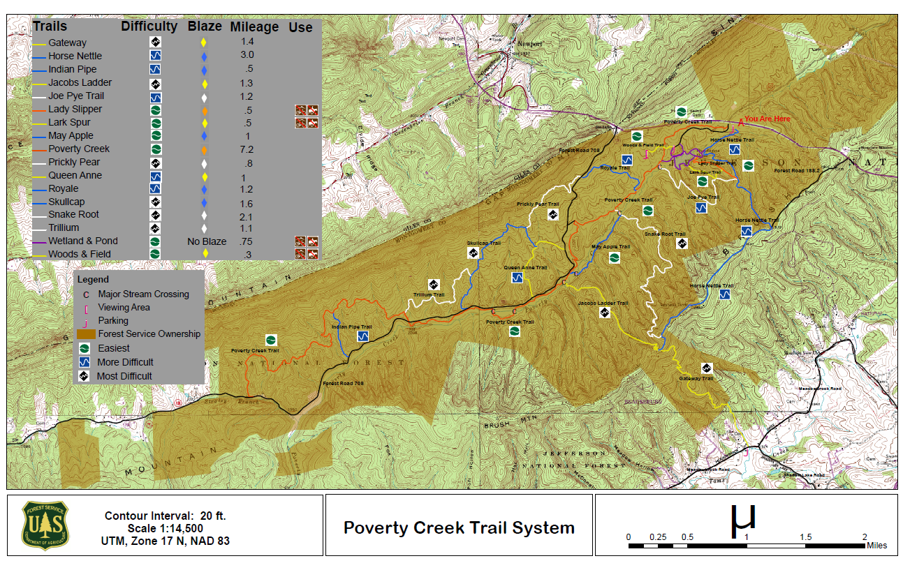
Poverty Creek Trail System Map
Moody Boat Launch Facility
Surrounded by a spectacular nature setting, sits the secluded Moody Boat Launch. Find pleasure in the convenient facility that allows one easy access to the South Fork of the Shenandoah River. Relish the fishing opportunities or soak up some sun on a lazy canoe ride. You might catch a glimpse of a Bald Eagle, the symbol of our nation, sitting proudly in the trees above or diving into the water after a meal.
Interior Whistle Stop Day Use Area Facility
The Whistle Stop is a spacious, family friendly place to spend an afternoon. Bring your hotdogs to cook on the grill while the kids splash in the creek, catch crawdads, or play on the child-sized wooden train. Big Stony Creek, a stocked trout stream, runs adjacent to Whistle Stop creating several great places to fish. Large white pine trees provide shade.
Blacksburg Shooting Range Facility
Located just outside Blacksburg, this site offers a rifle and pistol range as well as a shotgun and archery range. The rifle and pistol range is designed for firing at stationary paper targets up to 100 meters away. The lanes are sheltered from the sun and each one has a shooting bench that accommodates left and right-handed shooters. Shooters must bring their own targets; cardboard boxes or commercial paper targets work well. The shotgun range is designed for shooting clay targets, which must be provided by shooters. Archery is also permitted at the shotgun range.
White Cedar Horse Camp Facility
Built in 2006, this campground is located on top of Flat Top Mountain. It is perfect for camping with horses; there is plenty of shade and every site has a metal pipe corral. White Cedar’s main attraction is its proximity to a 20 mile system of intersecting trails of varied lengths and levels. You can ride directly from your campsite to the Flat Top Trailhead.
James River Ranger District Facility
Recreational opportunities in the James River Ranger District.
Poor Farm Dispersed Recreation Area Facility
Hiking and fishing opportunities are abundant at Poor Farm Dispersed Recreation Area. Enjoy hiking trails that meander along the Jackson River, or break out that rod and reel as the trout stocked waters are popular amongst fly and traditional fishermen alike.
Batzell Boat Launch Facility
Batzell Boat Launch sits perched on the riverbank. Stunningly clear water laps down the river and the beneficial facility allows easy access to the South Fork of the Shenandoah River. Relish the fishing opportunities or soak up some sun on a lazy canoe ride. Watch closely as you don’t want to miss an opportunity to spot the Otters frolicking alongside the riverbanks.
Hanging Rock Raptor Observatory Facility
A one-mile hike from the Hanging Rock parking area will take you to the raptor observatory, sitting high atop Peters Mountain on the Eastern Continental Divide. From this vantage point, visitors have a 360 degree view of the surrounding areas and an eye-level view of migrating raptors. The site is situated along a popular, southern migration path so raptor viewing is best in the autumn, but the hike and the view are great all year long.
Locher Tract (Glenwood & Pedlar) Facility
The Locher Tract is a 378 acre area that was once the Locher family’s farm and where they mined shale to sell to the brick-making plant across the river in Glasgow. Birdwatchers will enjoy a variety of common and unusual species including Pileated Woodpecker, American Goldfinch, Prothonatary and Prairie Warbler. Deer, turkey, rabbits, and other small game thrive in the woods and grassy areas, while the pond is home to waterfowl and beaver.
Whitetop Station Visitor Center Facility
Whitetop Station is a great starting point for an exciting bike ride down the Virginia Creeper Trail. Whitetop Station is a visitor center that shares the story of the local train history and mountain community through displays of historic photos and memorabilia. The current building, constructed in 2000, replaces the original train station that sat atop the highest point on the Abingdon Branch of the Norfolk and Western Rail Lines until it was abandoned in 1977.
BEARDS MOUNTAIN (FT #459) - WSRD Facility
This trail climbs to the top of Beards Mountain, and provides spectacular views of Warm Springs Mountain and the Cowpasture River Valley. The south end of the trail ends on the boundary line between the Forest Service and Douthat State Park, and offers a view of Douthat Lake. The Gillam Run Trail, also located on Forest Road 361 (Hickman Draft) and ending on the Beards Mountain Trail, provides another access point.
Trail Open To:


Comers Rock Recreation Area Facility
Located on top of Iron Mountain at 3800 feet, a small primitive campground and historic picnic area await the true outdoor enthusiast. The log picnic shelter with large stone fireplace was built by the Civilian Conservation Corp. Within walking distance of the campground are long distance hikes in Dry Run Wilderness, 360 degree views from Comers Rock Overlook and former fire tower, and the Unaka Nature Trail. Less than 2 miles away is Hale Lake for fishing, hiking, and canoeing.
Cascades Day Use Area Facility
Cascades Day Use Area is one of the most popular outdoor recreation spots in southwest Virginia. It features shady picnic spots, a native trout stream, and a 4-mile scenic loop trail. The main attraction is the scenic 66 foot Cascade Falls, a dramatic waterfall located two miles from the parking area.
Elizabeth Furnace Recreation Area Facility
Elizabeth Furnace Recreation Area offers forested trails, campsites and open grassy picnic areas along the tranquil Passage Creek. Enjoy hiking the Pig Iron and Charcoal trail and learn how iron was historically mined and smelted. Spend the day fishing from a stocked trout stream, grilling out at a picnic spot, or taking a stroll across the swinging bridge to view the historic cabin.
North River Ranger District Facility
Recreational opportunities in the North River Ranger District.
Camp Roosevelt Recreation Area Facility
Camp Roosevelt Campground is the site of the first Civilian Conservation Corps Camp in the Nation. Follow the path through the CCC camp and view the foundations where the actual buildings once stood. Proud and lofty oak trees create the perfect atmosphere for enjoying a simple picnic or camping out with friends or family.
Eastern Divide Ranger District Facility
Recreational areas and opportunities within the Eastern Divide Ranger District.
Wise Boat Launch Facility
The Wise Boat Launch, located on the North Fork of Pound Lake near Cane Patch Campground, serves as an easy access point for boaters and anglers.
Hawk Recreation Area Facility
Hawk Campground sits nestled in the Alleghany Mountains surround by a spectacular nature setting. Experience an exciting hiking experience with easy access to the Tuscarora Trail right from the campground. In the fall, this inviting location offers hunters a secluded environment to stay overnight. Fall asleep to the mellow sounds of the trees gently swaying overhead and the simple harmony of nearby crickets.
Seekford Boat Launch Facility
Under the deep blue skies, in a clear tranquil area, lies the secluded Seekford Boat Launch. Find pleasure in the facility that allows easy access to the South Fork of the Shenandoah River. Relish the fishing opportunities or soak up some sun on a lazy canoe ride. Tread lightly as you don’t want to scare away the cautious wild turkeys that have been seen foraging the woodlands nearby.
Pat Jennings Visitor Center Facility
The Pat Jennings Visitor Center serves as the headquarters and gateway to the Mount Rogers National Recreation Area. Located only 6 miles from I-81, the visitor center is in a peaceful mountain setting and adjacent to the Appalachian Trail. The center is a great place to learn more about the area and pick up maps, natures guides, and memorabilia. Clean restrooms, picnic tables, and the Two Ponds Nature Trail make this an ideal stop for visitors.
Walter Robinson Canoe Access Point Facility
Spend the day canoeing on the clean waters of the highly regarded Cowpasture River. This access point travels past the National Champion Yellow Buckeye, whose diameter is nearly 25 feet!
Wolf Gap Recreation Area Facility
Wolf Gap Recreation Area was once the site of a 1930’s African American Civilian Conservation Corps Camp. This recreation area has many hiking opportunities nearby. From here begin your hike to the popular Big Schloss Overlook with scenic views of Virginia and West Virginia mountains. Stay at one of our charming campsites and enjoy falling asleep to the peaceful symphony of nearby crickets.
Potts Slope Shooting Range Facility
This range is for rifle and pistol practice only. The lanes are sheltered from the sun and each one has a shooting bench that accommodates left and right-handed shooters. This range is designed for firing at stationary targets at 25, 50 & 100 yards. Shooters must bring their own paper targets to affix to the wire mesh fence.
BRUSHY RIDGE (FT#456) - WSRD Facility
Follow this trail across a stream and through mixed Appalachian hardwood forest as you climb Beards Mountain. Large rocks along the trail provide an intriguing setting and place for a good rest stop. If hiking in the summer remember to bring a container to pick the abundant blueberries and huckleberries. The trail ends on Nature Conservancy land at Trappers Lodge.
Trail Open To:
Clinch Ranger District Facility
Recreational opportunities in the Clinch Ranger District.
Birch Knob Observation Site Facility
Visitors to the Birch Knob Observation Tower enjoy views stretching from Virginia, to Kentucky, West Virginia, North Carolina, and Tennessee. Hikers are challenged by the Pine Mountain Trail that meanders along the ridge top between Kentucky and Virginia.
Fenwick Mines Day Use Area Facility
Visitors to Fenwick Mines will find trails to hike, ponds to fish, and a picnic shelter (complete with horseshoe pit) that’s perfect for spending a great Sunday afternoon with friends and family. A one mile, wheelchair accessible trail will lead you through wetland, stream, and forest habitats providing lots of opportunities to see wildlife.
MUD POND GAP (FT #544) - NRRD Facility
This trail is an old road that leads to Mud Pond, a vernal pool with a diverse habitat for amphibians.
Trail Open To:
FLATWOODS GROUP PICNIC AREA Campground
List of CampsitesOverview
Flatwoods Group Picnic area is a secluded site surrounded by forest. It is a great facility for family reunions, organization activities and other group events.Recreation
Open lawn areas are adjacent to the picnic area which can be used for activities such as horseshoes, sports and games (bring your own game and sports equipment). Hiking trails are available within easy driving distance (Guest River Gorge, Chief Benges Scout, and Little Stony Falls Trails).Facilities
A paved parking lot is close to the picnic shelter and restroom facilities. The picnic shelter has sinks with running water and a large built-in charcoal grill. The shelter also has electrical outlets where crockpots and other small appliances can be used. The picnic shelter is designed to be used for food preparation and as a serving area. Dining areas (picnic tables) are adjacent to the shelter but are outside and exposed to the weather. Men's and women's flush toilets are nearby.Natural Features
The nearby Guest River Gorge is full of scenic beauty, native flora and fauna, as well as historic features. The Guest River Gorge can easily be explored by hiking or biking a 5.8-mile trail built upon an old railroad grade. The trail follows the Guest River as it meanders through 8 branches and creeks and terminates at the Guest River's confluence with the Clinch River. The first 0.3-miles is handicap accessible. This scenic trail passes through riparian forest, 300-million year old cliff lines and sandstone outcrops, and remnants of the railway that once ran through this region to haul locally-mined coal and saltpeter. An abundance of wildlife is easily viewable along this trail. Migratory birds such as flycatchers, several species of warblers and tanagers can be found during the summer. The Guest River Gorge is an easy way to explore the rugged beauty of this mountainous area. Little Stony Creek flows through a 400-ft deep and 1,700-ft wide gorge. Large rock outcrops, ledges, and boulders add to the scenery along the creek. Hardwood and hemlock forest cover much of this area. Mountain laurel and rhododendron thickets lace the edges of these trails in many areas, as well. A popular destination on the district is Little Stony Falls, a 24-foot waterfall, along with two smaller waterfalls. The falls can be seen from walking the Little Stony National Recreation Trail. The trail is a 2.8-mile trail which goes from an upper trailhead (near the falls) and a lower trailhead at Hanging Rock Picnic Area. In some areas of the trail, hikers will need to climb around/over boulders and large rocks to remain on the trail. Sightseers, hikers and birdwatchers will all equally enjoy a visit to this area. Be sure to check with the local Ranger Station for trail conditions. Storm events and hazards may result in trails being closed.Nearby Attractions
The Guest River Gorge and Little Stony Falls are within easy driving distance.PHILLIP'S CREEK GROUP PICNIC AREA Campground
List of CampsitesOverview
Phillips's Creek Group Picnic area is a secluded site surrounded by forest. It is a great facility for family reunions, organization activities and other group events.Recreation
Open lawn areas are adjacent to the picnic area can be used for activities such as horseshoes, sports and games (bring your own game and sports equipment). Hiking trails are available within easy driving distance and include Pine Mountain and Red Fox Trails. The Phillip's Creek Trail is near the picnic area.Facilities
Parking is adjacent to the picnic shelters and restroom facilities. The restrooms are pit toilets. The toilets are adjacent to shelter #1 but are a short walk (850 feet) from shelter #2. A large charcoal grill is available at both shelters. Picnic tables are located inside the shelters. There is no electricity or drinking water available.Natural Features
The picnic area is surrounded by forest. The North Fork of Pound Reservoir is nearby and is a popular boating and fishing destination.Nearby Attractions
The Pine Mountain and Red Fox Trails are within easy driving distance.FOX CREEK HORSE CAMP Campground
List of CampsitesOverview
Fox Creek Horse Camp is a premiere destination for riding enthusiasts who are looking for the rare opportunity to ride from their campsite onto hundreds of miles of trails in the spectacular Mount Rogers National Recreation Area. Located at almost 4,000 feet, it serves as a welcome retreat for summer camping and horseback riding.Recreation
While hiking and horseback riding are the primary attractions near the campground, there are also ample native trout streams, the Mount Rogers Scenic Byway, local festivals and music, the Appalachian Trail and the Virginia Creeper National Recreation Trail.Facilities
This campground offers the basic amenities including pit toilets, garbage and manure collection, and visitor information.
