
Arapaho & Roosevelt National Forests Pawnee NG
The Arapaho National Forest was established by Theodore Roosevelt on July 1, 1908. The Roosevelt National Forest, originally part of the Medicine Bow Forest Reserve, was first named the Colorado National Forest in 1910 and was renamed by President Herbert Hoover to honor President Theodore Roosevelt in 1932. The Pawnee National Grassland was transferred to the Forest Service from the Soil Conservation Service in 1954. It was designated a national grassland in 1960.
RecAreaDirections
From Interstate 25 to the Supervisor's Office:
Take the Prospect Road exit and travel approximately four and one-half miles west. Turn left onto Centre Avenue (south). Our building is located at the third entrance (top of the hill) into the Natural Resources Research Center.
The Canyon Lakes District Office and Visitor Center (1st floor) and Arapaho and Roosevelt National Forests and Pawnee National Grasslands Headquarters (2nd floor) are co-located at:
2150 Centre Avenue, Building E Fort Collins, CO 80526
Open with Google MapMisc
| Stay Limit | |
| Reservable | false |
| Keywords | |
| Map Link | |
| Contact Phone | |
| Contact Email |
Permits info
Facilities
AA Bar Ranch (AA Barn) Group Picnic Site Campground
List of CampsitesOverview
Reservable, day-use site for group picnics and other gatherings next to the Colorado River, Rocky Mountain National Park, and a historic barn that is available for indoor activities. Site not shaded. Motorized access to site and use of barn facilities are by reservation only. Visitors may access on foot the river and Rocky Mountain Natinal Park trails located adjacent to the AA Barn Site. Dogs must be kept on a leash at all times at the AA Barn Site and adjacent Forest Service are, but dogs are prohibited in the Rocky Mountain National Park. Maximum number of people is 100 per day. The suggested vehicle limit is 20. Vehicles cannot be driven off the gravel areas. Do Not alter any features of the site, leave it as you find it. And, please pick up all trash and take it with you! Enjoy Your Stay.
Recreation
This barn is adjacent to a hiking entry point to Rocky Moutain National Park and has great fishing opportunities.
Facilities
The AA Barn is an enclosed space and has two floors. The upper floor is not available for use. The lower floor has electricity. The barn can be very cold late into the summer season due to the lack of sunlight and lack of heater. The barn can also get very hot during warm summer afternoons. The outside corrals are not suitable for livestock but do make beautiful photography backgrounds. Outside of the barn, there may be temporary, portable toilets. The barn is at the end of a gated, drivable road. The public has access to walk on the road but does not have access to drive down the driveway. Tables and chairs are provided. This includes; 10 banquet style tables, 90 folding chairs and 13 picnic tables.
Natural Features
The mountains in this area of Colorado are beautiful but the lodgepole pine beetle killed trees can be a challenge when it comes to photographs. The AA Barn used to be a working ranch and old corrals can be found on site. The Colorado River headwaters are adjacent to this barn and it is just below the Shadow Mountain Reservoir dam.
Nearby Attractions
- Green Ridge Campground
- Arapaho National Recreation Area
- Rocky Mountain National Park
- Grand Lake, Colorado
- Shadow Mountain Reservoir
- Lake Granby
contact_info
This location has limited staffing. Please call (970) 295-6600 for general information.Mount Evans Recreation Area Timed Tickets Timed Entry
Welcome to Mount Evans, the 14th tallest 14er in Colorado at 14,264 feet. It also happens to be the highest paved road in North America! On the 14-mile one-way drive, you can stop at Mount Goliath Nature Center, Summit Lake Park and the Summit Interpretive area of Mount Evans.
When you drive up the road and get above tree-line, you will be entering an alpine environment where the Mountain Goats, Marmots, and Bighorn Sheep call this place home year-round. You can also walk amongst the alpine wildflowers as well. It’s a harsh environment, but the plants and wildlife are well adapted to live on Mount Evans. The different environments on Mount Evans are one of a kind, and we want to keep them sustainable and be able to be visited for years to come. To help protect the purity and uniqueness of the area, we ask that you learn and practice ‘’Leave No Trace’’ ethics.
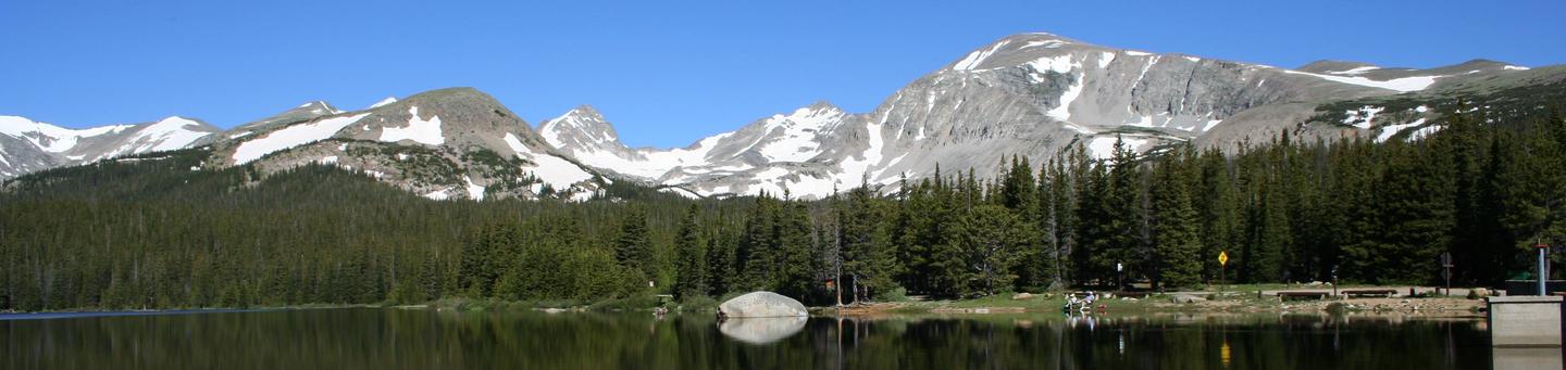
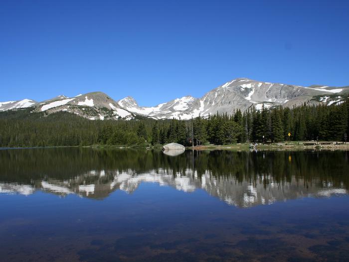
Brainard Lake Recreation Area Timed Tickets Timed Entry
The Brainard Lake Recreation Area is uniquely set in a glacially carved valley offering visitors spectacular panoramic views of Brainard Lake, surrounding subalpine forest, and high peaks along the Continental Divide. This is arguably the most popular destination on the Boulder Ranger District.
The Area serves as a key gateway to the Indian Peaks Wilderness, the most-accessible Wilderness area from the Denver metro area. Only two hours from Denver via I-70 and the Peak-to-Peak Scenic Byway, the trailheads for Wilderness camping or popular day hikes as well as fishing, camping, picnicking, hiking, snowshoeing, cross-country skiing, and other dispersed recreation opportunities both in and outside the Indian Peaks Wilderness all begin in Brainard Lake Recreation Area.
This area uses a timed ticket reservation system to protect it from excessive human impacts, help meet local health department requirements, and facilitate a positive recreation experience.
Arapaho and Roosevelt National Forests Christmas Tree Permit Tree Permit
MOUNTAIN PARK Campground
List of CampsitesOverview
Mountain Park Campground is located on the Cache la Poudre River, 40 miles northwest of Fort Collins, Colo., along Highway 14. Visitors enjoy the area for its great rafting, fishing and hiking opportunities.Recreation
The Cache La Poudre River offers whitewater rafting and fishing. Anglers cast for brown, cutthroat and rainbow trout.Hiking, biking and horseback riding trails are in the surrounding area, including the Mt. McConnel Trail, William R. Kreutzer National Recreation Trail and Young Gulch Trail.
Volleyball and basketball courts, a playground and horseshoe pits are located in the campground. Other popular activities include birding and wildlife viewing.
Facilities
The campground offers accessible single- and double-family sites, and a group site that can accommodate up to 75 people. Sites 1 through 32 have electric hookups. Sites 33 through 54 do not have hookups.Picnic tables, 12x15' tent pads, campfire rings and grills are provided, as are vault toilets and drinking water. Coin showers are located on-site. Dead and downed firewood may be gathered in the forest or purchased from the host.
Natural Features
The canyon's vegetation varies from dense forests to open meadows, surrounded by steep mountains. A forest of ponderosa pine trees covers the campground, which is situated on the banks of the Cache la Poudre River, Colorado's first National Wild and Scenic River.CHAMBERS LAKE Campground
List of CampsitesOverview
Chambers Lake Campground is located approximately 60 miles north of Fort Collins, Colo., on beautiful Chambers Lake. Visitors enjoy the area for its great fishing and canoeing, as well as abundant trail opportunities and wilderness access.Recreation
Popular activities included fishing, canoeing and boating on Chambers Lake, which is a no-wake lake. Anglers cast for rainbow, cutthroat and lake trout. A boat ramp is located within the campground. Please note the boat ramp may be unusable in late summer due to low water levels. The lake is a storage reservoir for irrigation water and is drawn down over the course of the summer.
The Blue Lake Trail No. 959 begins nearby. The 7.2-mile trail provides access to the Rawah Wilderness. Several additional hiking and biking trails can be found in the surrounding area.
Facilities
The campground offers single and double family campsites, many of which are accessible. Each site contains a picnic table and campfire ring. Vault toilets and drinking water are provided. A playground area is located within the campground.Natural Features
The campground is situated in a rustic, mountainous area, at an elevation of 9,200 feet. Some sites have reduced shade because many hazardous lodgepole pine trees have been removed due to the mountain pine beetle epidemic.Nearby Attractions
Many hiking and horseback riding trails in the area provide access to the Neota and Comanche Peak wilderness areas, which are located nearby.contact_info
For facility specific information, please call (801) 226-3564.DOWDY LAKE Campground
List of CampsitesOverview
Dowdy Lake Campground is located 48 miles northwest of Fort Collins, Colo., near the village of Red Feather Lakes. Visitors enjoy the area for its canoeing, fishing and trail opportunities.Recreation
Canoeing and fishing are popular activities on the 115-acre, no-wake Dowdy Lake. Motorized boats are allowed on the lake, but a 10 mph speed limit is enforced. Anglers cast for brown, brook, cutthroat and lake trout. Several additional lakes are in the vicinity.Many hiking, biking and horseback riding trails are in the surrounding area, including the 4-mile Mount Margaret Trail. Several off-road vehicle trails are located within five miles of the campground.
Other popular activities include viewing wildlife and visiting the nearby Redfeather Visitor Center.
Facilities
The campground offers 60 accessible single and double family campsites with electric hookups. Ten sites are designated for tent camping only and do not have hookups. Each site contains a tent pad, picnic table and campfire ring with grill.Vault toilets, drinking water and trash collection are provided. Dead and downed firewood may be gathered in the forest or purchased in bundles from the campground host.
Natural Features
The campground is situated in a ponderosa pine forest on the shore of Dowdy Lake, at an elevation of 8,200 feet. Afternoon thunderstorms can be expected during spring and summer months.Due to the mountain pine beetle infestation and removal of hazardous trees, some sites have reduced shade.
Nearby Attractions
The small village of Red Feather Lakes is nearby, offering limited dining options, gift shops, general stores, a library, post office and a golf course.WEST LAKE Campground
List of CampsitesOverview
West Lake Campground is located 48 miles northwest of Fort Collins, in north central Colorado, near the village of Red Feather Lakes. Visitors enjoy the area for its canoeing, fishing and trail opportunities.Recreation
Canoeing and fishing are popular activities on the 25-acre, no-wake West Lake. Anglers cast for rainbow and lake trout. Several additional lakes are in the vicinity.Many hiking, biking and horseback riding trails are in the surrounding area, including the 1.5-mile West Lake Trail and 4-mile Mount Margaret Trail. Several off-road vehicle trails are located within five miles of the campground.
Other popular activities include viewing wildlife and visiting nearby Redfeather Visitor Center.
Facilities
The campground offers 31 accessible single- and double-family campsites, with electric hookups. Five additional sites are designated for tent camping only and do not have hookups. Each site contains a tent pad, picnic table and campfire ring with grill.Vault toilets and drinking water are provided. Firewood may be gathered in the forest or purchased from the campground host.
Natural Features
The campground is situated in a ponderosa pine forest, on the shore of West Lake, at an elevation of 8,200 feet. Afternoon thunderstorms can be expected during spring and summer months.Due to the mountain pine beetle infestation and removal of hazardous trees, some sites have reduced shade.
Nearby Attractions
The small village of Red Feather Lakes is nearby, offering limited dining options, gift shops, general stores, a library, post office and golf course.Cold Springs - Arapaho Roosevelt NF (CO) Campground
List of CampsitesOverview
Cold Springs Campground is located on the Arapaho Roosevelt National Forest, north of Blackhawk on the Peak to Peak Scenic Byway/Highway 119, in north central Colorado. Visitors enjoy the area for its scenic and off-road driving, and nearby hiking and fishing opportunities.Recreation
The surrounding area has many great hiking trails. There is an easy hiking trail out of the campground for families with small children. In addition, the short, but steep Vista Trail climbs just a quarter-mile but rewards hikers with spectacular views of the vast Mount Evans Wilderness Area and valley below.Scenic driving is available along Highways 119 and 72, known as the Peak to Peak Scenic Byway. Numerous creeks, rivers and lakes in the area provide fishing opportunities. Off-road enthusiasts will find many jeep roads in the vicinity.
Facilities
There are 38 sites in the campground. Sites 1 through 5 are pull-over's with wooden retaining walls. You climb several steps to reach the picnic tables, fire rings and tent pads. These sites are not suitable for RVs with slide-outs. Sites 9 & 11 are pull-over's which also will not accommodate large RVs or slide-outs.Each site has a picnic table and fire ring or grate. The maximum vehicle length that can be accommodated is 40 feet. Most sites are shaded and the interior roads are gravel. Water hydrants, tent pads, vault toilets and trash service are provided. There is a playground for small children.
Natural Features
The campground is located in a mountainside aspen and lodgepole pine forest, at an elevation of 9,200 feet.Nearby Attractions
The historic mining town of Central City is nearby. Popular events held in the town include Lou Bunch Day and the Central City Opera and Jazz festivals.Golden Gate Canyon State Park is just seven miles away. The scenic park offers over 35 miles of hiking trails. Mountain biking and horseback riding are allowed on some trails. Every stream and pond in the park is open to fishing.
ECHO LAKE Campground
List of CampsitesOverview
Echo Lake Campground is located on the Arapaho and Roosevelt National Forests in central Colorado near its namesake lake at the base of Mount Evans along Hwy 103. Visitors enjoy hiking, fishing and taking scenic drives along Mount Evans Road.Recreation
Activities in the area include hiking in the Mount Evans Wilderness, fishing, scenic driving and wildlife viewing. Several trails leave directly from the campground.Facilities
The campground offers 11 sites more suited to RV camping and seven sites designated for tent camping only. Each site is equipped with a picnic table and campfire ring. Also, there are vault toilets, hand pumps with potable water and trash service.Natural Features
Echo Lake sits in a spruce forest near the shores of Echo Lake. The campground's 10,600' elevation creates cool to chilly nights, even in summer, and its location on a mountain pass makes for windy conditions year-round.The Arapaho and Roosevelt National Forests and Pawnee National Grassland on the foothills and slopes of the Rocky Mountains in Colorado. The forests and grassland cover 1.5 million acres and extend north to the Wyoming border, south to Mount Evans and west across the Continental Divide.
The area encompasses mountains, lakes and five scenic byways, designated by Congress for their scenery, wildlife or history, including the highest road in North America. Mount Evans Road, also known as Colorado Highway 5, allows visitors to drive from 10,500' to 14,130' above sea level in just 14 miles.
Nearby Attractions
Nearby Idaho Springs, a former mining town, makes for a nice outing. History buffs will appreciate the Argo Gold Mine and Mill Museum. The City and County of Denver Mountain Park, Echo Lake and Echo Lake Lodge are located adjacent to the campground.PICKLE GULCH Campground
List of CampsitesOverview
Pickle Gulch is a group picnic and camping facility located just off the Peak to Peak Scenic Byway/Highway 119. Visitors enjoy the area for its scenic and off-road driving, and nearby hiking and fishing opportunities.Recreation
Many hiking and biking trails are found nearby. Scenic driving is available along Highways 119 and 72, which is also known as the Peak to Peak Scenic Byway. Numerous creeks, rivers and lakes in the area provide fishing opportunities. Off-road enthusiasts will find many jeep roads in the vicinity.Facilities
Pickle Gulch is an area that offers day-use picnic sites and six campsites to accommodate large groups. The picnic site can accommodate up to 150 people and is equipped with picnic tables and campfire circles. A parking area, vault toilets and a playground are provided.The group campsites are all walk-to sites for tent camping only. The on-site host has wheelbarrows available for campers, to haul equipment from the parking area. Each campsite is equipped with picnic tables, a campfire circle and tent pads. Vault toilets and drinking water spigots are shared between sites.
A separate day-use area contains two volleyball courts, horseshoe pits, picnic tables and a vault toilet.
Firewood may be gathered from the surrounding forest, if available, or purchased from the host.
Natural Features
The site offers many scenic views of the surrounding area. It is set among a fairly level forest of lodgepole pine trees, dotted with aspens.Due to the mountain pine beetle infestation and removal of hazardous trees, there may be little to no shade at these sites.
Nearby Attractions
The historic mining town of Central City is nearby. The town hosts various popular events, including Lou Bunch Day and the Central City Opera and Jazz festivals.Golden Gate Canyon State Park is a short drive from the campground. This scenic park offers more than 35 miles of hiking trails. Mountain biking and horseback riding are also allowed on some trails. Every stream and pond within the park is open to fishing.
WEST CHICAGO CREEK Campground
List of CampsitesOverview
West Chicago Creek Campground sits along its namesake creek at the base of Mount Evans and is located off Highway 103 on the Arapaho and Roosevelt National Forests in central Colorado. It is a popular facility for hiking and fishing enthusiasts.Recreation
The area provides easy access to many hiking trails that lead into the Mount Evans Wilderness. West Chicago Creek offers good fishing for rainbow, brown and brook trout.Facilities
There are 15 sites available all suitable for RV and tent camping. Each site contains a tent pad, picnic table, charcoal grill and fire ring. Other amenities include a vault toilet, water spigot and trash dumpster. There are no RV hook-ups. Firewood is available for sale during peak season at the campground.Natural Features
The campground sits at an elevation of 9,600 feet in an aspen and lodgepole pine forest.The Arapaho and Roosevelt National Forests and Pawnee National Grassland are located in the foothills and slopes of the Rocky Mountains in Colorado. The forests and grassland cover 1.5 million acres and extend north to the Wyoming border, south to Mount Evans and west across the Continental Divide.
The area encompasses mountains, lakes and five scenic byways, designated by Congress for their scenery, wildlife or history, including the highest road in North America. Mount Evans Road, also known as Colorado Highway 5, allows visitors to drive from 10,500' to 14,130' above sea level in just 14 miles.
Nearby Attractions
Nearby Idaho Springs, a former mining town, makes for a nice outing. History buffs will appreciate the Argo Gold Mine and Mill Museum.ARAPAHO BAY Campground
List of CampsitesOverview
Arapaho Bay Campground is located on Lake Granby, southeast of Grand Lake, in north central Colorado. Visitors enjoy the area for its great boating, fishing and hiking opportunities.Recreation
Lake Granby is part of the Arapaho National Recreation Area. It offers boating, sailing, swimming and fishing. Anglers cast for kokanee salmon and a variety of trout, including rainbow, brown, mackinaw and cutthroat. National Fishing Week is held the first week of June each year.
Numerous hiking and horseback riding trails are located within the Arapaho National Recreation Area, including the Roaring Fork Trail, Monarch Lake Trail and the East Shore Trail (which is part of the Continental Divide National Scenic Trail).
Facilities
The campground offers three loops of single- and double-family sites, a few of which are accessible. Each site is equipped with a picnic table, campfire ring and tent pad. Vault toilets, drinking water and trash collection are provided.Natural Features
The campground is situated on Arapaho Bay, on the eastern tip of Lake Granby, at an elevation of 8,300 feet. Afternoon thunder showers should be expected during the summer months.Due to the mountain pine beetle infestation and consequent hazardous tree removal, the campground offers little to no shade.
Nearby Attractions
Rocky Mountain National Park's west entrance is just north of Grand Lake. With lush valleys and craggy peaks reaching elevations over 14,000 feet, visitors are provided opportunities for countless breathtaking experiences and adventures. Scenic driving, hiking, backpacking, fishing, horseback riding and wildlife viewing are popular activities in the park.GREEN RIDGE Campground
List of CampsitesOverview
Green Ridge Campground is located on beautiful Shadow Mountain Reservoir, southwest of Grand Lake in north central Colorado. Visitors enjoy the area for its great boating, fishing and hiking opportunities.Recreation
Shadow Mountain Lake is part of the Arapaho National Recreation Area. It offers boating, swimming and fishing. Anglers cast for kokanee salmon, as well as rainbow, brown, mackinaw and cutthroat trout. A boat ramp and dock are located within the campground. The Colorado River can also be accessed from the campground. National Fishing Week is held annually the first week of June.Numerous hiking and horseback riding trails are in the vicinity, including the East Shore Trail (which is part of the Continental Divide National Scenic Trail), Roaring Fork Trail and Monarch Lake Trail.
Facilities
The campground offers several single-family sites, as well as one double and one triple capacity campsite. Picnic tables, campfire rings and tent pads are provided, as are flush and vault toilets and drinking water. Firewood may be gathered in the forest or purchased from the host.Natural Features
The campground is situated between the southern shore of Shadow Mountain Lake and the banks of the Colorado River, at an elevation of approximately 8,300 feet. Afternoon thunderstorms should be expected during the summer months.Due to the mountain pine beetle infestation and consequent removal of hazardous trees, there is little to no shade available in the campground. Since 2008, 3,000 pine seedlings have been planted to remedy the problem in the future.
Nearby Attractions
Rocky Mountain National Park's west entrance is located north of Grand Lake. With lush valleys and craggy peaks reaching elevations higher than 14,000 feet, visitors are provided opportunities for countless breathtaking experiences and adventures. Scenic driving, hiking, backpacking, fishing, horseback riding and wildlife viewing are popular activities in the park.STILLWATER (COLORADO) Campground
List of CampsitesOverview
Stillwater Campground is located on Lake Granby, six miles southeast of Grand Lake, in north central Colorado. Visitors enjoy the area for its great boating, fishing and hiking opportunities. The necessary Arapaho National Recreation Area pass can now be purchased online (Interagency Age and Access passes are also valid)!
Recreation
Lake Granby is part of the Arapaho National Recreation Area. It offers boating, sailing, swimming and fishing. Anglers cast for kokanee salmon and rainbow, brown, mackinaw and cutthroat trout. A boat ramp and dock are located on-site. National Fishing Week is held annually the first week of June. Numerous hiking and horseback riding trails are located within the Arapaho National Recreation Area, including the East Shore Trail (which is part of the Continental Divide National Scenic Trail), Roaring Fork Trail and Monarch Lake Trail.Facilities
This campground is the largest one available on the Arapaho and Roosevelt National Forest. It offers 129 sites, 21 of which have electric hookups. Single- and double-family campsites are available and some are accessible. Each site is equipped with a picnic table, campfire ring and tent pad. Parking can accommodate RVs of many sizes; spurs range from 25 to 40 feet in length.Flush and vault toilets, showers, drinking water and a dump station are provided.
Natural Features
The campground is situated on the northern shore of Lake Granby, at an elevation of 8,300 feet. Afternoon thunderstorms should be expected during the summer months. Due to the mountain pine beetle infestation and consequent removal of hazardous trees, the campground has little to no shade.Nearby Attractions
Rocky Mountain National Park's West Entrance is located north of Grand Lake. With lush valleys and craggy peaks reaching elevations higher than 14,000 feet, visitors are provided opportunities for countless breathtaking experiences and adventures. Scenic driving, hiking, backpacking, fishing, horseback riding and wildlife viewing are popular activities enjoyed by visitors to the park.KELLY DAHL Campground
List of CampsitesOverview
Kelly Dahl Campground is located adjacent to the Peak-to-Peak Scenic Byway, near the historic mining towns of Nederland, Rollinsville, Central City and Black Hawk.Recreation
Although no formal trails exist in the campground, a few closed roads offer campers the opportunity to explore the surrounding area. West Magnolia and East Portal Trailheads offer trails within a short drive. The Rollins Pass Road (Moffat Road) and other off-road routes can be found in the vicinity.The lakes across the highway are on private property and access is prohibited.
Facilities
The campground offers 46 single-family sites that will accommodate tents, trailers or RVs. Campsites #1 through #20 are first-come, first-served. Each site is equipped with a picnic table and campfire ring with grill. There is a maximum of eight people per site. Vault toilets, drinking water, and trash collection are provided throughout the campground. Firewood is for sale in campground. The road through the campground is gravel/dirt.A playground suitable for small children is located within the campground.
Natural Features
The campground is situated among ponderosa pines, on a gentle slope, at an approximate elevation of 8,600 feet.Due to the mountain pine beetle infestation and consequent hazardous tree removal, the campground offers little to no shade.
contact_info
For facility specific information, please call (801) 226-3564.Nearby Attractions
The town of Nederland, which is four miles north of the campground, offers grocery and hardware stores, restaurants, gas, a post office, bank and Barker Reservoir.OLIVE RIDGE Campground
List of CampsitesOverview
The Olive Ridge Campground is located within the Roosevelt National Forest, situated near the southeastern corner of Rocky Mountain National Park at an elevation of 8,350 feet.Recreation
Olive Ridge is close to the Wild Basin area of the Rocky Mountain National Park. Several trailheads are in the area, including Wild Basin, Finch Lake and Sandbeach Lake trails. Popular activities include fishing, hiking and mountain climbing.Facilities
There are 56 sites in the campground. Twenty six are suitable for RV camping and 30 are more suitable for tents. Tents must be confined to the provided tent pads (14'x16'). There is a maximum of eight people per single site. Sites #26 and #39 are oversized and will accommodate 10 people at an additional fee. Each site has a picnic table and fire ring or grill. Vault toilets, andd trash services are provided. Firewood is for sale in the campground.Natural Features
This peaceful campground is heavily wooded with a mixture of ponderosa pine and aspen trees. The interior roads are gravel/dirt.Afternoon thunderstorms should be expected during the summer months.
Nearby Attractions
Rocky Mountain National Park's main entrance is 14 miles north of the campground, in Estes Park. With lush valleys and craggy peaks reaching elevations higher than 14,000 feet, visitors are provided opportunities for countless breathtaking experiences and adventures. Scenic driving, hiking, backpacking, fishing, horseback riding and wildlife viewing are popular activities in the park.Estes Park is a full-service community 15 miles from the campground. Dining, shopping, rafting, fly fishing, horseback riding and golfing opportunities await. Lake Estes offers boating, sailboarding and fishing.
contact_info
For facility specific information, please call (801) 226-3564.PAWNEE Campground
List of CampsitesOverview
Pawnee Campground is located in the Brainard Lake Recreation Area, off the Peak to Peak Scenic Byway, 35 miles south of Estes Park and the main entrance to the Rocky Mountain National Park. Visitors enjoy the area for its fishing, canoeing and hiking opportunities.Recreation
Brainard Lake is a popular destination for canoeing, kayaking and fishing. Anglers cast for rainbow, brown and cutthroat trout. Long Lake, Red Rock Lake and Left Hand Reservoir are nearby.Several trails in the area provide access to the adjacent Indian Peaks Wilderness Area. Hiking is allowed on all trails; mountain biking is allowed outside the wilderness area. Rock climbing, snowshoeing and cross country skiing are often available, weather permitting.
Facilities
The campground offers several single-family campsites, each equipped with a picnic table and campfire ring. Vault toilets and drinking water are provided.Natural Features
The campground lies at the foot of the Continental Divide, next to 25-acre Brainard Lake and the Indian Peaks Wilderness Area at an elevation of 10,350 feet. A scenic forest of spruce and fir trees covers the area. Summertime temperatures are warm in the day and cool at night. Afternoon thunderstorms are common.Nearby Attractions
The town of Nederland is 14 miles south of the campground, offering grocery and hardware stores, restaurants, gas, a bank and a post office.Rocky Mountain National Park's main entrance is 35 miles north in Estes Park. With lush valleys and craggy peaks reaching elevations higher than 14,000 feet, visitors are provided opportunities for countless breathtaking experiences and adventures. Scenic driving, hiking, backpacking, fishing, horseback riding and wildlife viewing are popular activities in the park.
Estes Park is a full-service community. Dining, shopping, rafting, fly-fishing, horseback riding and golfing opportunities are available there. Lake Estes offers boating, sailboarding and fishing.
contact_info
For facility specific information, please call (801) 226-3564.GUANELLA PASS Campground
List of CampsitesOverview
Guanella Pass Campground is located about 7 miles south of Georgetown on the South Fork of Clear Creek on the Guanella Pass Scenic Byway. Located at an elevation of 10,900 feet on the Arapaho Roosevelt National Forest, visitors to the campground can also enjoy hiking and fishing in the area.The Guanella Pass Scenic and Historic Byway follows an old wagon route that linked the mining towns of Georgetown and Grant, Colorado.
Recreation
Visitors can go trout fishing on the South Fork of Clear Creek. Silver Dollar Lake is nearby, but cannot be reached by car. Instead, the Silver Dollar Lake Trail leads hikers above treeline to the scenic lake.Facilities
The campground is split into two loops by the county road and South Clear Creek. There are 18 sites in the campground. Eleven are suitable for RV camping and seven are more suitable for tents. Large RVs are not recommended on the byway. Most of the sites are in the open with some tent sites located among some spruce trees. Each site has a tent pad, picnic table, fire ring and charcoal grill. The roads through the campground are gravel. This facility provides hand pumps with potable water, vault toilets and trash dumpsters.Natural Features
The Arapaho and Roosevelt National Forests and Pawnee National Grassland sit along the foothills and Rockies of Colorado. The forests and grassland cover 1.5 million acres and extend north to the Wyoming border, south to Mount Evans and west across the Continental Divide.The area includes mountains, lakes and five scenic byways, designated by Congress for their scenery, wildlife or history, including the highest road in North America. Mount Evans Road, also known as Colorado Highway 5, allows visitors to drive from 10,500' to 14,130' above sea level in just 14 miles.
Nearby Attractions
Visitors enjoy touring historic Georgetown, a former mining town of about 1,000 residents. Additional ghost towns dot the region.PEACEFUL VALLEY Campground
List of CampsitesOverview
Peaceful Valley Campground is situated in a glacial valley, on the banks of the Middle Saint Vrain Creek at an elevation of 8,500 feet in northern Colorado. The campground has some conifer trees with open grassy areas.Recreation
The Middle Saint Vrain Creek is a good fly-fishing stream where anglers cast for rainbow, brown and cutthroat trout.Many trails in the vicinity are open to hiking and biking, including Sourdough and Buchanan Pass Trails. Mountain biking is allowed on the first five miles of Buchanan Pass Trail.
The Bunce School Roads are popular among off-road enthusiasts.
Facilities
There are 17 sites in the campground. Nine are suitable for RV camping and eight are more suitable for tents. Each site has a picnic table, fire ring and grill. The maximum vehicle length that can be accommodated is 45 feet, although no utility hookups are available. There is a maximum of eight people per site; site #17 is oversized and will accommodate ten people. The roads in the campground are paved. There is one hand pump with potable water, trash dumpsters, vault toilets and firewood is for sale.Natural Features
The campground is situated on the banks of the Middle Saint Vrain Creek in the mostly flat, glacial Peaceful Valley. A mixed conifer and aspen forest covers the area.contact_info
For facility specific information, please call (801) 226-3564.Nearby Attractions
Rocky Mountain National Parkâ??s main entrance is 24 miles north in Estes Park. Estes Park is a full-service community.CAMP DICK Campground
List of CampsitesOverview
Camp Dick is the site of a Civilian Conservation Corps camp that was established in the 1930s. It is located just off the Peak to Peak Scenic Byway, on the Middle Saint Vrain Creek.Recreation
The Middle Saint Vrain Creek is a good fly-fishing stream where anglers cast for rainbow, brown and cutthroat trout.Many trails in the vicinity are open to hiking and biking, including Sourdough and Buchanan Pass trails. The Indian Peaks Wilderness boundary is four miles from the west end of the campground.
Mountain biking is allowed on the first five miles of Buchanan Pass Trail. Bikers can ride a loop from Peaceful Valley or Camp Dick, via Buchanan Pass Trail and Middle Saint Vrain Road, or Coney Cutoff and Coney Creek Roads and Sourdough Trail.
The Middle Saint Vrain and Bunce School roads are popular among off-road vehicle enthusiasts.
Guided horseback riding is available at Peaceful Valley Lodge, which is just over a mile away.
Facilities
Campsites will accommodate tents and RVs. Sites includes picnic tables and campfire ring with grill. Water spigots, vault toilets, and trash services are provided at the campground. Firewood may be purchased during the peak season. There are no electrical hook-ups, dump stations, or showers. Tents must remain on tent pads.Natural Features
The campground is situated on the banks of the Middle Saint Vrain Creek in a glacial valley surrounded by mixed conifer and aspen forests and an open meadow.contact_info
For facility specific information, please call (801) 226-3564.Nearby Attractions
The town of Allenspark is less than 10 miles north of the campground, and has a restaurant and a grocery store.Rocky Mountain National Park's main entrance is 25 miles north of the campground, in Estes Park. With lush valleys and craggy peaks reaching elevations higher than 14,000 feet, visitors are provided opportunities for countless breathtaking experiences and adventures. Scenic driving, hiking, backpacking, fishing, horseback riding and wildlife viewing are popular activities available within the park.
Estes Park is a full-service community. Dining, shopping, rafting, fly fishing, horseback riding and golfing opportunities are available there. Lake Estes offers boating, sailboarding and fishing.
COLUMBINE CAMPGROUND Campground
List of CampsitesOverview
Columbine Campground is located just off the Peak to Peak Scenic Byway/Highway 119, west of Denver, in north central Colorado. This campground is popular with off-road enthusiasts and many jeep roads can be reached from the campground.Recreation
Many hiking and biking trails are found nearby. Scenic driving is available along Highways 119 and 72, which is also known as the Peak to Peak Scenic Byway. Numerous creeks, rivers and lakes in the area provide fishing opportunities. Off-road enthusiasts will find many jeep roads in the vicinity.Facilities
This campground has 46 sites on two loops. Five of these sites are suitable for tents only; the others are suitable for both RV and/or tents. Each site has a picnic table, campfire ring and grill. Other amenities include: vault toilets, water spigots and trash service. Bundled firewood is for sale by the onsite campground manager. RV units are not permitted to fill tanks from the water spigots. All of the sites are non-electric.Natural Features
The campground's two loops are situated in a grove of aspen and lodgepole pine, at an elevation of 9,200 feet.Highway 279 is gravel to the campground and the interior campground road is dirt.
Due to the mountain pine beetle infestation and removal of hazardous trees, there may be little to no shade available in the campground.
Nearby Attractions
The historic mining town of Central City is nearby. Popular events there include Lou Bunch Day and the Central City Opera and Jazz festivals.Golden Gate Canyon State Park is a short drive from the campground. This scenic park offers over 35 miles of hiking trails. Mountain biking and horseback riding are allowed on some trails. Every stream and pond in the park is open to fishing.
Charges & Cancellations
A $10.00 service fee will apply if you change or cancel your reservation. Late cancellations are subject to additional fees. For full details see NRRS Reservation Policy.BELLAIRE LAKE CAMPGROUND Campground
List of CampsitesOverview
Bellaire Campground is located 47 miles northwest of Fort Collins, Colo., near the Red Feather Lakes village. Visitors enjoy the area for its canoeing, fishing and trail opportunities.Recreation
Canoeing and fishing are popular activities on 10-acre, no-wake Bellaire Lake. Anglers cast for rainbow and brook trout, among other species. The campground is within walking distance of the lake via an accessible boardwalk. Several additional lakes are in the vicinity.Many hiking, biking and horseback riding trails are in the surrounding area, including the 1.25-mile Molly Lake Trail and 4-mile Mount Margaret Trail. Several off-road vehicle trails are located within five miles of the campground.
Other popular activities include viewing wildlife and visiting nearby Redfeather Visitor Center.
Facilities
The campground offers accessible single, double and triple family sites with electric hookups. Five additional sites are designated for tent camping and do not have hookups. Each site contains a tent pad, picnic table and campfire ring with grill.Flush toilets, vault toilets and drinking water are provided. Dead and downed firewood may be gathered in the forest or purchased from the campground host.
Natural Features
The campground is comprised of rolling hills, pine forests and unique rock formations. It sits near Bellaire Lake at an elevation of 8,600 feet. Afternoon thunderstorms can be expected during spring and summer months.Due to the mountain pine beetle infestation and the removal of hazardous trees, there may be little to no shade in the campground.
Nearby Attractions
The small village of Red Feather Lakes is nearby, offering limited dining options, gift shops, general stores, a library, post office and a golf course.Charges & Cancellations
A $10.00 service fee will apply if you change or cancel your reservation. Late cancellations are subject to additional fees. For full details see NRRS Reservation Policy.STUB CREEK CABIN Campground
List of CampsitesOverview
Stub Creek Cabin is located on the north end of the Laramie River Valley in north-central Colorado. It is a well-equipped cabin that provides guests with a comfortable stay and many modern amenities, as well as access to a variety of recreational opportunities. Visitors to the area enjoy hiking and horseback riding, as well as hunting and viewing wildlife. The cabin was built by the Civilian Conservation Corps in 1936 and was originally used as lodging for the district ranger's family and Forest Service employees. It can be accessed by vehicle. Guests are responsible for their own travel arrangements and safety, and must bring several of their own amenities.Recreation
Visitors to the area enjoy a variety of recreational activities, including hiking, horseback riding and backpacking along many trails within the surrounding forest. Off-highway vehicles (OHV) are permitted on nearby designated roads. There are no OHV routes on site at the Stub Creek cabin site.
Hunting and fishing are also available in the area and visitors are responsible for knowing the various rules and regulations. Wildlife viewing is also popular.
Facilities
The cabin is fully furnished with indoor plumbing and electricity. It can accommodate up to five people and has two single beds with mattresses in each of the two bedrooms and a futon couch in the living room. The cabin is also equipped with a fireplace. The kitchen is equipped with running water, a stove and oven, refrigerator, microwave, coffee maker and toaster. Cooking pots and utensils, a table and chairs, as well as dishes and eating utensils are provided. A picnic table is available outdoors and the facility provides firewood and garbage collection services. Guests will need to bring their own bedding, including pillows, blankets and/or sleeping bags, as well as towels, toiletry items and food and beverages, and any other necessary personal items.Natural Features
The cabin is about 75 miles from Fort Collins, in the Arapaho and Roosevelt National Forests and Pawnee National Grassland. It sits in an open area, at an elevation of 8,400 feet. The facility is surrounded by spruce, fir and lodgepole pine trees. Stub Creek passes through the area and is a short walk from the cabin.
Abundant wildlife, including moose, deer, elk, bear, and many bird species, make their home in the area.
Nearby Attractions
The town of Walden (pop. 600) is one hour southwest of Stub Creek cabin by car. It was named Colorado's moose viewing capital in 1995. Basic services are available there. Laramie, Wyoming (pop. 33,000) is a full-service town located a little over an hour's drive northwest of Stub Creek cabin.JACKS GULCH Campground
List of CampsitesOverview
Jacks Gulch Recreation Area is located 48 miles northwest of Fort Collins, in northern Colorado. Visitors enjoy the area for its great hiking, biking and horseback riding opportunities.Recreation
Popular activities include hiking, biking, horseback riding, birding and viewing wildlife. A nature trail circles the entire area of Jacks Gulch, with one section providing stunning views of the Mummy Range.Facilities
The campground offers an accessible group site with electric hookups, and five equestrian campsites without hookups. Additional single-family campsites are available on a first-come, first-served basis.The group site accommodates up to 60 people, several cars and up to nine RVs with hookups. Ten 14-by-17 tent pads are scattered throughout the site. A picnic shelter is provided. Two central cooking and picnic areas are on-site, each with four picnic tables, a charcoal grill and campfire ring.
The two equestrian sites have four horse stalls each. Picnic tables, campfire rings and tent pads are provided. Each site can accommodate a horse trailer.
Vault toilets, drinking water and trash collection are provided. Firewood, dead and down, may be gathered in the forest or purchased from the host.
Natural Features
The campground is situated in a ponderosa pine forest, dotted with aspens. Grassy meadows are scattered throughout the area.CROW VALLEY Campground
List of CampsitesOverview
Crow Valley Recreation Area is set in the Pawnee National Grassland, a very popular site with bird enthusiasts. Over 200 species can be found in the area. Hiking and star gazing are favorite activities in this remotely located campground.Recreation
Birding, exploring nature trails, viewing wildlife and star gazing are popular activities at Crow Valley. A volleyball court, horseshoe pit and ball field are available.The Lee and Dorothy Rhoads Farm Implement Museum is located within the recreation area. The collection of tools, donated by the descendants of homesteaders, can help one imagine what life was like in pioneer days.
Facilities
Crow Valley Recreation Area contains four types of sites: a family campground, group overnight sites (Hawk, Plover and Lark), a group picnic area and an educational site (EDU). Vault toilets and drinking water are provided.Each family site is equipped with a picnic table and campfire ring.
The group overnight sites can be reserved separately or together. Picnic tables and a campfire circle form a common area at each site. Tent pads are arranged around each common area. Parking is adjacent to each site. These sites have very little shade.
The group picnic area can accommodate up to 200 people for day-use. It includes a lighted, covered shelter with several electrical outlets, 31 tables and a large barbeque grill.
The Steward J. Adams Educational Site is accessible and can accommodate up to 100 people for overnight or day-use. It includes a three-sided covered shelter with electrical outlets and tables.
Natural Features
Crow Valley sits at an elevation of 4,800 feet. Cottonwood and elm trees dot the landscape, providing pleasant shade in the family campground. However, the group campsites have little to no shade. Short grass prairie surrounds the recreation area.
The Pawnee National Grassland sits east of the Rocky Mountains in Colorado. Eroding creek drainages crisscross the area. Elevations range from 4,375 feet on the prairie to 5,685 feet.
Nearby Attractions
The campground is within driving distance from both the east and west units of Pawnee National Grassland and the Pawnee Pioneer Trails Scenic Byway, a 128-mile route through wide-open terrain studded by the towering Pawnee Buttes.CUTTHROAT BAY GROUP Campground
List of CampsitesOverview
Cutthroat Bay Group Campground is located on Lake Granby, six miles southeast of Grand Lake in north central Colorado. Visitors enjoy the area for its great boating, fishing and hiking opportunities.Recreation
Lake Granby is part of the Arapaho National Recreation Area. It offers boating, sailing, swimming and fishing. Anglers cast for kokanee salmon and rainbow, brown, mackinaw and cutthroat trout. A boat ramp and dock are located nearby. National Fishing Week is held annually the first week of June.Numerous hiking, biking and horseback riding trails are located within the Arapaho National Recreation Area, including the East Shore Trail (which is part of the Continental Divide National Scenic Trail), AA Barn Loop Trail, Roaring Fork Trail and Monarch Lake Trail.
Facilities
The campground offers two accessible group campsites that accommodate up to 30 people each. Each site is equipped with a picnic shelter, tables, a campfire circle and 12 tent pads.Vault toilets and drinking water are provided. A volleyball court and horseshoe pits are also available at the campground.
Natural Features
The campground is situated on the northern shore of Lake Granby, at an elevation of 8,300 feet. Afternoon thunderstorms should be expected during the summer months.Due to the mountain pine beetle infestation and consequent removal of hazardous trees, the campground provides no natural shade.
Nearby Attractions
Rocky Mountain National Park's west entrance is located north of Grand Lake. With lush valleys and craggy peaks reaching elevations higher than 14,000 feet, visitors are provided opportunities for countless breathtaking experiences and adventures. Scenic driving, hiking, backpacking, fishing, horseback riding and wildlife viewing are popular activities enjoyed at the park.WILLOW CREEK GROUP Campground
List of CampsitesOverview
Willow Creek Group Campground is located on Lake Granby, six miles north of Granby, in north central Colorado. Visitors enjoy the area for its great canoeing, kayaking, fishing and hiking opportunities.Recreation
Willow Creek Reservoir is a 300-acre, no-wake lake. It is open to canoes, kayaks and other non-motorized boats. Anglers fish for rainbow, brown and brook trout. Willow Creek can be accessed nearby. National Fishing Week is held annually the first week in June.Numerous hiking and horseback riding trails are located within the Arapaho National Recreation Area, including the East Shore Trail (which is part of the Continental Divide National Scenic Trail), Roaring Fork Trail and Monarch Lake Trail.
Facilities
The campground offers one tent-only campsite that accommodates up to 20 people. Single-family campsites are available at the campground on a first-come, first-served basis. Picnic tables, campfire rings, grills and tent pads are provided, as are vault toilets and drinking water.Natural Features
The campground is situated on the southern shore of Willow Creek Reservoir, at an elevation of 8,130 feet. Afternoon thunderstorms should be expected during the summer months.Due to the mountain pine beetle infestation and consequent removal of hazardous trees, there is no shade within the campground.
Nearby Attractions
Lake Granby, Shadow Mountain Lake and Grand Lake are all nearby. Boating, sailing, fishing and hiking are popular activities.The west entrance of Rocky Mountain National Park's is just north of Grand Lake. With lush valleys and craggy peaks reaching elevations higher than 14,000 feet, visitors are provided opportunities for countless breathtaking experiences and adventures. Scenic driving, hiking, backpacking, fishing, horseback riding and wildlife viewing are popular activities in the park.
South Fork Group Site - Arapaho NF (CO) Campground
List of CampsitesOverview
South Fork Group Campground is located in north central Colorado in the Williams Fork Valley next to South Fork Creek. Many mountain streams and creeks nearby offer good fishing opportunities. South Fork is the only facility in the area designated for horse camping.Recreation
The South Fork Trail begins at the campground and is one of the most popular trails in the valley. The 26-mile loop trail is open to hiking and horseback riding, and provides access to other trails in the area, including Ptarmigan Pass, Ute Peak and Jones Pass Trails. Mountain biking opportunities also exist in the valley. The Byers Peak Wilderness can be accessed nearby.Anglers enjoy trout fishing on the South Fork Creek and numerous additional streams and creeks in the surrounding area. Wildlife viewing opportunities abound.
Facilities
The campground offers one reservable, accessible group site that can accommodate up to 25 people. Individual sites are available on a first-come, first-served basis. Picnic tables, campfire rings and tents pads are provided, as are flush and pit toilets and drinking water. A small corral, for one or two horses, is located in the campground.Natural Features
The campground is located in the Williams Fork Valley next to South Fork Creek at an elevation of 8,962 feet. A cool mountain climate with frequent afternoon thunderstorms should be expected.Due to the pine beetle infestation and hazardous tree removal, shade has been reduced throughout the campground.
The Arapaho and Roosevelt National Forests and Pawnee National Grassland sit on the foothills and peaks of the Rocky Mountains in Colorado. The forests and grassland cover 1.5 million acres and extend north to the Wyoming border, south to Mount Evans and west across the Continental Divide.
STOVE PRAIRIE Campground
List of CampsitesOverview
Stove Prairie Campground is located on the Cache la Poudre River, 26 miles northwest of Fort Collins, in north central Colorado. Visitors enjoy the area for its great rafting, fishing and hiking opportunities.Recreation
The Cache la Poudre River offers whitewater rafting and fishing. Anglers cast for brown, cutthroat and rainbow trout.Hiking, biking and horseback riding trails are in the surrounding area, including the Mt. McConnel Trail, William R. Kreutzer National Recreation Trail and Young Gulch Trail.
Other popular activities include birding and wildlife viewing.
Facilities
The campground offers eight accessible, single-family campsites. Four sites are walk-to tent sites. Each site is equipped with a 12-by-15 tent pad, table and campfire ring with grill.Accessible vault toilets are provided. Dead and downed firewood may be gathered in the surrounding forest, or purchased from the campground host.
Natural Features
The canyon's vegetation varies from dense forests to open meadows, surrounded by steep mountains. The campground is situated among ponderosa pine and aspen trees on the banks of the Cache la Poudre River, Colorado's first National Wild and Scenic River.NARROWS (CO) Campground
List of CampsitesOverview
Narrows Campground is located on the Cache la Poudre River, 32 miles northwest of Fort Collins, Colorado, along Highway 14. Visitors enjoy the area for its great rafting, fishing and hiking opportunities.Recreation
The Cache la Poudre River offers whitewater rafting and fishing. Anglers cast for brown, cutthroat and rainbow trout.Hiking, biking and horseback riding trails are in the surrounding area, including the Mt. McConnel Trail, William R. Kreutzer National Recreation Trail and Young Gulch Trail.
Other popular activities include birding and wildlife viewing.
Facilities
The campground offers accessible single-family sites, including eight walk-to tent sites. Each site is equipped with a 12x15' tent pad, a picnic table and a campfire ring with grill.Vault toilets and drinking water are provided. Dead and downed firewood may be gathered in the forest or purchased from the host.
Natural Features
The canyon's vegetation varies from dense forests to open meadows, surrounded by steep mountains. The campground is situated among ponderosa pine and aspen trees on the banks of the Cache la Poudre River, Colorado's first National Wild and Scenic River. The lower loop drops off steeply to the river.ANSEL WATROUS Campground
List of CampsitesOverview
Ansel Watrous Campground is located on the Cache la Poudre River, 22 miles northwest of Fort Collins, Colo., along Highway 14. Visitors enjoy the area for its great rafting, fishing and hiking opportunities.Recreation
The Cache la Poudre River offers whitewater rafting and fishing. Anglers cast for brown, cutthroat and rainbow trout, among other species of fish.Hiking, biking and horseback riding trails are in the surrounding area, including the 4-mile Young Gulch Trail.
Other popular activities enjoyed by visitors to the campground include birding and wildlife viewing.
Facilities
The campground offers accessible single-family sites, each equipped with a 12-by-15 tent pad, a picnic table and a campfire ring with grill.Vault toilets and drinking water are provided. Dead and downed firewood may be gathered in the forest or purchased from the campground host.
Natural Features
The canyon's vegetation varies from dense forests to open meadows and the campground is surrounded by steep mountains. The campground is situated among Ponderosa pines on the banks of the Cache la Poudre River, Colorado's first river designated as a National Wild and Scenic River.contact_info
For facility specific information, please call (801) 226-3564.Charges & Cancellations
A $10.00 service fee will apply if you change or cancel your reservation. Late cancellations are subject to additional fees. For full details see NRRS Reservation Policy.Mestaa’ėhehe Mountain Fire Lookout Campground
List of CampsitesOverview
The Mestaa’ėhehe (pronounced mess-taw-HAY) Mountain Fire Lookout is located directly off of Colorado Highway 103 west of Bergen Park and sits at the summit of Mestaa’ėhehe Mountain, which is an active communication tower site in Clear Creek County. In addition to being an active communication site, the area is a popular dispersed recreation use area with hiking, recreational shooting, cross country skiing, snowshoeing, and camping. The lookout is a unique structure constructed of native granite which is situated at over 11,000 feet elevation and was built in the 1940s by the Civilian Conservation Corps. The cab measures 14 feet by 14 feet and is completely lined by windows on each side and surrounded by a catwalk, all of which sit on top of a one story stone base.
The Fire Lookout is open for reservations. We are excited to open the lookout, but wanted to share the following updates with renters:
-There will not be staff cleaning in between visitors to the lookout, all renters must thoroughly disinfect and clean before they leave.
-Pack out all trash and anything brought up during your stay, please do not leave food, supplies or other items behind.
-We will offer disposable items for eating. However, renters are encouraged to bring their own supplies. Reusable utensils/cups will not be provided.
-Follow instructions for the incinerating toilet and do not burn disposable wipes or other cleaning items.
-If you are sick or have been exposed to COVID 19, please stay home, cancel your reservation and a refund will be provided.
Recreation
Hiking, wildlife viewing, scenic driving, picnicking, snowshoeing, and cross-country skiing are all easily accessible while staying at the lookout.Facilities
The lookout contains an electric stove, refrigerator, and heat; beds; table and chairs; cookware and dishes; and an exterior incinerating toilet. Please be aware that visitors are expected to clean and maintain the incinerating toilet to ensure proper operation of the unit. The lookout can accommodate four people per night. Guests will need to bring their own water for drinking, cooking and cleaning purposes, as well as their own sleeping bags/bedding. This is a pack it in, pack it out facility; guests will need to carry out all trash and clean the facility prior to leaving.
During the winter months, the facilities will be cold. In the lookout, there are two small wall heaters, and one space heater. However, with the weather conditions, it’s not always possible for them to keep the place consistently warm. At 11,000 feet it can also be extremely windy. Please come prepared for the extreme winter weather conditions that can happen during your stay.
Natural Features
Besides offering the unique experience of staying in a fire lookout, Mestaa’ėhehe Mountain Lookout will provide visitors outstanding panoramic views of the Great Plains, Denver, Mount Evans, Pikes Peak, Longs Peak and other snow-capped peaks.
contact_info
For facility specific information, please call (303) 567-3000.Nearby Attractions
Mount Evans Recreation Area, Mount Evans Wilderness AreaDunraven Trailhead Facility
This trailhead gives acces to the North Fork Trail (#929) and Bulwark Ridge Trail to Signal Mountain (#928-1). You will find room for 23 vehicles and a vault toilet at the trailhead.
Jacks Gulch Trailhead Facility
Jacks Gulch trailhead accommodates approximately approximately 12 vehicles
Long Draw Parking (Winter) Trailhead Facility
In snowy months, Long Draw Road is closed. But, this is a popular area for snowmobiles. Be aware that other winter activities take place here, including cross country skiing and snowshoeing.
Signal Mountain (Bulwark Ridge) Trailhead Facility
Signal Mountain (Bulwark Ridge) Trailhead
Bellaire Lake Picnic Site Facility
The Bellaire Lake Day Use Area provides parking and picnic opportunities adjacent to Bellaire Lake. A fee is required to use this area. There are nine picnic sites available and each has a table and pedestal grill. There is a restroom and drinking water available.
The primary use of this area is picnicking and fishing. There is a wheel-chair accessible trail to the lake and a fishing point. Please contact the Colorado Parks and Wildlife for fishing regulations and licensing.
Bennett Creek Picnic Site Facility
This picnic area is situated next to County Road 63E (Pingree Park Road) where it crosses Bennett Creek. It is in an open coniferous forest with steep mountainous topography. There is a parking area, two picnic sites, with a table and fire grate, and a restroom available. There is no drinking water. Primary use of this area is picnicking and fishing in Bennett creek.
Big Thompson River Fishing Site Facility
Due to the 2013 flood damage, the remains of this site were removed for safety. Reconstruction of the fishing pier is expected to take place in 2018.
Bridges River Access Point (Put-In) Facility
Bridges River Access Point (Put-In)
Bridges River Access Point (Take-Out #2) Facility
Bridges River Access Point (Take-Out #2)
Bridges River Access Point (Take-Out) Facility
Bridges River Access Point (Take-Out)
Cameron Pass Picnic Site Facility
This picnic site is located on the crest of Cameron Pass along Colorado Highway 14 in a subalpine forest setting with scenic views. There is parking and four picnic sites with tables and fire grates. A restroom is available but no drinking water. There are hiking, scenic viewing, and fishing opportunities nearby.
Creedmore Lake Fishing Site Facility
These lakes are located north of Red Feather Lakes.
Filter Plant River Access Point (Put-In) Facility
Filter Plant River Access Point (Put-In)
Fish Creek Picnic Site Facility
The Fish Creek picnic area has seven sites, each with a picnic table. The site is on the Pingree Park Road (63E) and is south of the Fish Creek Trailhead.
Freewater Bridge Fishing Site Facility
Freewater Bridge Fishing Site
Grandview Campground Campground
List of CampsitesGrandview Campground is a small, tents-only facility with nine campsites. It is located near the west end of Long Draw Reservoir with views of the reservoir and Rocky Mountain National Park. There is a common parking area for all the sites with paths to the individual walk-in campsites. Vegetation varies from open grass to conifers. Each site has a tent pad, picnic table and fire grate. The most popular activity in the area is fishing but it also provides access to hiking opportunities in the nearby Neota Wilderness and National Park.
Home Moraine Geological Interpretive Site Facility
This kiosk is located in the Poudre Canyon along Highway 14.
Indian Meadows Fishing Site Facility
Indian Meadows Fishing Site
Kelly Flats Campground Campground
List of CampsitesKelly Flats is a first-come, first-served campground located adjacent to Colorado Highway 14 and the Cache La Poudre River. There are 29 sites available including four walk-in tent sites. This is primarily an open conifer forest setting but there is a variety of vegetation found along the riparian zone of the river. Each site contains a tent pad, fire grate and picnic table. The primary activities in this area include stream fishing and enjoying the ambience of the river as it flows through the campground.
Long Draw #1 Fishing site Facility
Long Draw #1 Fishing site
Long Draw #2 Fishing Site Facility
Long Draw #2 Fishing Site
Long Draw #3 Fishing Site Facility
Long Draw #3 Fishing Site
Long Draw Campground Campground
List of CampsitesLong Draw Campground is situated near Long Draw Reservoir. Long Draw has 25 sites including three double sites. Each site has a picnic table and fire grate. Popular activities in the area include reservoir and stream fishing and hiking.
North Fork Poudre Campground Campground
List of CampsitesThe North Fork Poudre Campground is located along the Deadman Road west of Red Feather Lakes, near the banks of the North Fork Cache la Poudre River in a dense lodgepole pine forest. This is an older facility with short parking spurs that will not accommodate larger RVs. Each of the nine sites have a picnic table, tent pad and fire grate. Recreational activities in the area include hiking, stream fishing and four-wheel driving.
Pineview River Access Point (Put-In, Take-Out) Facility
Pineview River Access Point (Put-In, Take-Out)
Sleeping Elephant Campground Campground
List of CampsitesThis campground is located adjacent to Highway 14 in an open ponderosa pine setting near its namesake, Sleeping Elephant Mountain. The mountain and the inherent sleeping elephant is visible from the campground. The Cache la Poudre River is nearby but it is mostly on private land within the immediate vicinity. There are 15 sites each with a picnic table and fire pit. This is an older facility and will not accommodate larger RVs. Popular activities in the area include fishing, hiking and scenic driving.
West Lake Day Use Area Facility
This is a day use fee area that provides parking and access to West Lake. There are seven picnic sites at this facility, each with a table and fire pit or grill.
Fishing is the most popular activity at this area. A fee is required. Please contact the Colorado Department of Parks & Wildlife for fishing regulations and licensing.
Lee and Dorothy Rhodes Farm Implement Museum Facility
Mid-19th century pioneers settled on the short-grass prairie, in northeastern Colorado, and tried their hand at farming. A Pawnee chief once said, “Grass no good upside down." During the Great Depression and Dust Bowl of the 1930s, farmers experienced the wisdom of that comment in this arid, windy region. Those who stayed learned many lessons, and adjusted their ways and their tools. Today, historic farming equipment is on display at the Lee and Dorothy Rhodes Farm Implement Museum, within Crow Valley Recreation Area. This collection of equipment, donated by the descendants of homesteaders, can help one imagine what life was like in pioneer days.
Pawnee Buttes Trailhead Facility
The Pawnee Buttes are located in the northeast corner of Weld County, Colorado, approximately 13 miles south of the Wyoming border. A predominant geologic feature within the Pawnee National Grassland, the Buttes rise 300 feet above the prairie.
A 1.5 mile trail leads hikers to the first Butte. The second Butte is on private land. If there is a gate, leave it the same way you found it. As the rock is crumbling sandstone, climbing on the Buttes is not recommended.
Take a hat, sunscreen, and plenty of water, as temperatures may top one hundred degrees in July and August.
Please do not disturb any hawks and falcons nesting in the rocky cliffs. The Pawnee Buttes trail is open year round; however, there is a nearby closure annually from March 1 – June 30 to protect any nesting raptors. To clearly understand what is closed, check this map. Please stay on the main trail during this time as adults may desert their eggs or young birds if disturbed.
Pawnee Bird Tour Facility
May 29, 2018 Update: Recent rains have flooded some areas and made others muddy. County Road 96 on the east side of the bird tour is experiencing some flooding. Use caution.
The Pawnee National Grassland Bird Tour (click here for pamphlet) is 21 miles long and passes through a variety of bird habitats. The kinds of birds present will depend upon the season of the year, weather conditions, and time of day (early morning and late afternoon are best). The tour begins in the Crow Valley Recreation Area and follows county roads, mostly unpaved and gravel, through a variety of landscapes and ending at Highway 14 and County Road 61.
A leisurely tour would take from up to 3 to 4 hours to complete by motor vehicle. The tour is also suitable for mountain bikes with heavy duty tires. To follow the tour, please call or come by our office in Greeley to pick up a brochure and map, or click here for a downloadable version. A more complete list of bird species found on the Pawnee National Grassland is available by clicking here. Pay close attention to the map and your odometer. Wet weather can make some of the roads impassable. You may want to inquire at the office for the latest conditions before you start the tour.
If you are interested in exploring more of the Pawnee National Grassland, a Motor Vehicle Use Map will indicate where public and private lands are located, and which roads for accessible for public use. A free pamphlet on “Pawnee Pioneer Trails: Scenic & Historic Byway” is also available from our office and may be of interest.
There is no water available in this area, and the nearest gas station may not be in close proximity. Check your fuel and take plenty of water, especially on hot summer days.
Learn more from Discover Weld's video.
Crow Valley Recreation Area Facility
Crow Valley Recreation Area is set in the Pawnee National Grassland, a very popular site with bird enthusiasts. Over 200 species can be found in the area. This oasis on the prairie has cottonwoods which provide some shade and small meadows, and is surrounded by northeastern Colorado's short-grass prairie. There are ample opportunities for sports and recreation for the whole family.
Crow Valley sits at an elevation of 4,800 feet. Cottonwood and elm trees dot the landscape, providing pleasant shade in the family campground. However, the group campsites have little to no shade. Short grass prairie surrounds the recreation area. The Pawnee National Grassland sits east of the Rocky Mountains in Colorado. Eroding creek drainages crisscross the area. Elevations range from 4,900 feet on the prairie to 9,500 feet at the summit of the Pawnee Buttes.
Birding, exploring nature trails, viewing wildlife and star gazing are popular activities at Crow Valley. A volleyball court, horseshoe pit and ball field are available. The Lee and Dorothy Rhoads Farm Implement Museum is located within the recreation area. The collection of tools, donated by the descendants of homesteaders, can help one imagine what life was like in pioneer days.
Bright Extension Trailhead Facility
Located 2.2 miles east of County Road 82E on the south side of Johnny Park Road (National Forest System Road 118), the trailhead is marked with a small sign near a minor saddle. This trailhead provides access to the Bright Extension Trail.
Acccess to the trailhead is seasonal. For current information on road openings and closures, check the Road Status Table.
View an area map here.
Meeker Park Overflow Campground Campground
List of CampsitesThere are 29 first-come, first-served campsites that allow tents, campers, trailers, and RVs. Sites are best for tent camping due to unpaved roads, steep hills and short pull-ins. Picnic tables, fire rings, and portable toilets are provided. 14-day stay limit. There is no drinking water, electricity, hook-ups, dump stations, nor showers. A maximum of eight people are allowed per site.
Although not a full-service campground, Meeker Park Overflow Campground tends to fill to capacity on weekends due to its proximity to Estes Park and Rocky Mountain National Park. Longs Peak Trailhead is approximately two miles north of the campground, and the Wild Basin Trailhead is about two miles to the south.
Click here for a map of this campground.
Rainbow Lakes Campground Campground
List of CampsitesThis campground is open mid-June through mid-September and located at 10000 feet at the end of the Rainbow Lakes Road and adjacent to the Indian Peaks Wilderness. This road is closed for winter and typically reopens in June. Before traveling to this area, check the Road Status Table.
There are 18 first-come, first-served campsites that accommodate tents (on 14X16 foot tent pads) and small trailers. A maximum of eight people are allowed per site. Campsite 8 is oversized and accomodates up to 15 people. Campsites 15 - 18 are walk in sites for tents. Picnic tables, fire grates, vault toilets and trash services are provided at each campsite. 14-day stay limit. This campground does not feature drinking water, electricity, hook-ups, dump stations, nor showers. Please remember to bring water.
Rainbow Lakes Campground is normally full for the weekend by Friday morning so plan to arrive early. No reservations are accepted.
Click here for a map of this campground.
South Saint Vrain Trailhead Facility
The South Saint Vrain Trailhead is the trailhead for the east end of the South Saint Vrain Trail (#909). Parking is very limited, allowing room for only two or three vehicles.
View an area map here.
Clear Creek Picnic Site Facility
The Clear Creek Picnic Site is located along Highway 40 in a spruce and fir forest setting with scenic views.
Facilities: There are 13 sites with picnic tables and fire grates. A restroom is available, but there is no drinking water.
Recreation: There are hiking, scenic viewing, camping, and fishing opportunities nearby.
View a COTREX map here.
Clear Lake Picnic Site Facility
The Clear Lake Picnic Site is located along the Guanella Pass Road.
Facilities: Each site is equipped with a picnic table and fire grate. A restroom is available, but there is no drinking water.
Recreation: There are several hiking, scenic viewing, camping and fishing opportunities nearby.
View a COTREX map here.
Loveland Pass Trailhead Facility
The Loveland Pass Trailhead is located just south of I-70 and provides summer and winter recreation opportunities.
Loveland Ski Area is located at the eastern end of the pass, and Arapahoe Basin is located on the west side. The pass itself is a popular destination for backcountry skiers.
There are no facilities at this trailhead.
View a COTREX map here.
Mount Evans Summit / Interpretive Site Facility
Drive the highest paved road in North America. Whether it is for the views, wildlife or history, “The Top” offers something for everyone. To the east, look out at the plains of Colorado and the Denver area. To the west, take in views of the continental divide, including Grays and Torreys peaks, the only 14,000 foot mountains on the Continental Divide. Longs Peak in Rocky Mountain National Park is visible to the north. Pikes Peak, South Park and New Mexico's Sangre de Cristo Mountain's can be seen to the south. There are three significant structures at “The Top,” two of which are historic: the ruins of the Crest House, the High Altitude Lab and the Meyer-Womble Observatory. The Crest House was first open to the public in 1942, serving as a restaurant and souvenir shop. In 1979, the Crest house burned in a propane fire. The oldest structure up there is The High Altitude Lab. A wooden double A-frame building that was constructed by the University of Denver in 1935 to support cosmic ray research. In 1979, the University of Denver added a telescope, which in 1997, was expanded into an observatory. Take advantage of interpretive signs onsite that tell the story of these structures in great detail.
Summit Lake Trailhead Facility
1
Bill Moore Lake/Empire Loop Facility
The Bill Moore/North Empire Loop is a network of roads for OHV opportunities located north of Empire.
This road is very rocky and steep, especially to Bill Moore Lake. A 4-wheel drive, high-clearance vehicle is highly recommended.
Refer to the Clear Creek Ranger District's Motor Vehicle Use Map for more information about OHV opportunities in the area.
Note: Due to high elevation, the area is not generally snow-free until late June or even July in some years. Best late spring through fall.
View a COTREX map here.
Saxon Mountain Facility
Saxon Mountain road north of Georgetown is a steep shelf road with many switchbacks. Good view of Georgetown and surrounding mining history. The road is wide most of the way but very narrow in a few places. Rock falls are a common occurrence with the possibility that a large boulder could block the road at any time. A high-clearance/4-wheel drive vehicle is recommended. Refer to the Ranger District's motor vehicle use map (MVUM) for more information on roads in this area. Click here for more information about dispersed camping near Idaho Springs and Georgetown.
Alpine Gardens Loop (#49) Facility
Length: .25 miles ONE-WAY
Elevation: 12,113 feet - 12,209 feet
Trail Description: Begin at the Upper Goliath Trailhead. This is a wonderful wildflower hike. The best time for wildflowers is late June to mid-August. For a longer hiker, hike the M. Walter Pesman Trail (#50) down 1.5 miles to the Mount Goliath Natural Area.
Note: Due to high elevation, the trails in some years are not generally snow-free until late June or mid-July.
View a COTREX trail map here.
Sulphur Ranger District, near Winter Park & Granby Facility
Recreational opportunities abound in this haven located high up in the Rocky Mountains. The Sulphur Ranger District is over 442,000 acres in Grand County, Colorado. Being surrounded by mountain peaks, meadows and lakes, you are in for a truly majestic experience in this forest.
Summers are filled with mountain biking near the towns of Winter Park and Fraser, hiking or backpacking in one of the five Wilderness areas or in the Arapaho National Recreation Area (ANRA), and enjoying the wildflowers and wildlife.
Many of the hiking trails are also open to equestrians. The Three Lakes of Grand, Granby and Shadow Mountain are great places to escape with your boat or a fishing pole for a day. The Stillwater area next to the town of Grand Lake has miles of trails for off-highway vehicle (OHV) enthusiasts. Camping cannot be overlooked either with 15 campgrounds and nearly 500 campsites.
Bull Mountain Campground Campground
List of CampsitesMinimally developed campground without individually numbered campsites. No picnic tables or fire rings present. Most campsites lack shade.
Year-round, however, the access road is closed to motor vehicles between Nov. 15 and June 15.
Idleglen Trailhead Facility
Trailhead featuring access to extensive motorized trail system known as Stillwater Pass and Grand Lake trail system. Access via the Idelglen Staging Area. Facilities include restrooms and information kiosk.
Idlewild Campground Campground
List of CampsitesLocated next to US Highway 40 and just before the town of Winter Park, this first-come, first-served campground has 24 non-electric sites that will accommodate tents, trailers and RVs. Each site contains a tent pad, fire grate and picnic table. Additional facilities include restrooms, trash service, drinking water, and bear boxes for food storage. Campground Map
Lake Evelyn Trailhead Facility
The Lake Evelyn Trailhead provides access to several trails in the Byers Peak Wilderness. There are no facilities.
Note: The access road to this trailhead is closed to motor vehicles between Nov. 15 and June 15. A 4-wheel drive, high clearance vehicle is recommend to reach this trailhead.
View a COTREX area map here.
Midland Group Campground Campground
List of CampsitesThis minimally developed group campground is located next to the Fraser River near Winter Park. The campground is well shaded.
Robbers Roost Campground Campground
List of CampsitesThe Robbers Roost Campground is located next to Hwy 40 and the Fraser River near Winter Park.
Facilities: There are 11 non-electric sites that will accommodate tents, trailers, and RVs. Each site contains a tent pad, fire grate and picnic table. Additional facilities included restrooms and trash service. Water is available at the Idlewild Campground 5.5 miles away.
Natural Features: The campground is located in the forest so there is ample shade. The Fraser River runs by the campground.
Recreation: Popular recreation activities include hiking in the Arapaho National Forest and the nearby Vasquez Peak Wilderness, scenic driving and wildlife viewing.
View a COTREX map here.
Sunset Point Campground Campground
List of CampsitesThe Sunset Point Campground is a first-come, first-served campground located within the Arapaho National Recreation Area on the shores of Lake Granby.
Facilities: There are 25 non-electric shaded sites that will accommodate tents, trailers and RVs. Each site contains a tent pad, fire grate and picnic table. Additional facilities include restrooms, trash service, drinking water and a boat ramp.
Recreation: Popular activities include fishing and boating in Lake Granby, hiking, scenic driving and wildlife viewing.
View a COTREX map here.
Williams Fork Trailhead Facility
The Williams Fork Trailhead is located near the South Fork Campground in the Williams Fork Valley. There is parking for about 5 vehicles. Picnic tables are provided.
Note: The access road is closed to motor vehicles between Nov. 15 and June 15.
View a COTREX map here.
Echo Lake Trailhead Facility
Echo Lake Trailhead is located south of Idaho Springs on Hwy 103. It provides access to the Chicago Lakes Trail (#52) and the Resthouse Meadows Trail (#57).
Facilities include vault toilets and seasonal water.
View a COTREX map here.
Boulder Canyon Facility
Carved by the rushing waters of Middle Boulder Creek, Boulder Canyon is popular for scenic driving, fishing and rock climbing. Land in this area is a mix of city, county, national forest and private lands. Have a map showing land ownership if you plan on venturing away from the main road. Watch for signs alerting to private land or area closures.
The Motor Vehicle Use Map for the Boulder Ranger District displays roads open to motorized travel and is available online and at the Boulder Ranger District offfice.
Redfeather Visitor Center Facility
The Redfeather Visitor Center is located at 274 Dowdy Lake Road, at the eastern edge of the town of Red Feather Lakes, and close to fishing opportunities at West Lake.
The Redfeather Visitor Center was built by Civilian Conservation Corps workers between 1937 and 1939, as part of the Redfeather Ranger District. That district office was eventually combined with the Estes-Poudre Ranger District to form the Canyon Lakes Ranger District, which is headquartered in Fort Collins. One of the former administrative offices now serves as a visitor center. Staff is available during summer months to answer questions about recreation, distribute informational brochures, and sell Arapaho and Roosevelt National Forests maps.
CLRD Dispersed camping Facility
You may camp within 300 feet of most Forest Service roads and some Larimer County Roads as long as you are on National Forest System lands.
Contact the Canyon Lakes Visitor Center at 970-295-6700 for a free Motor Vehicle Use Road Map (MVUM) or view it here . The MVUM shows roads where dispersed camping is allowed. Also view the CLRD Dispersed Camping map (pdf, 301KB) that shows areas where camping is restricted or prohibited.
Find out if there are any Forest campfire restrictions during your trip. If fires are allowed, use established fire rings where they exist. Put out your fire until it is cold to the touch.
Johnny Park Road (#118) Facility
Nine and a half miles east of Estes Park on Highway 36, a forest access sign directs you west on a gravel road towards the Big Elk Meadows subdivision. The Johnny Park Road is 6 miles on this road. Ten miles south of Estes Park on Highway 7, take the Big Owl or Cabin Creek Road north of Meeker Park.
At the junction of 118.1 and County Road 47, there are around 3 trailer spots before the gate. Dispersed camping with a trailer is very limited on #118 due to the roughness of the road.
Pole Hill Road (#122) Facility
Pole Hill Road is located 3 miles east of Estes Park off Highway 36. Pole Hill Road starts on private land with many side roads branching off. The National Forest boundary is .9 mile from the highway. There is no designated parking lot and parking is limited to around 2 trailers at the beginning. Please do not block roads. Dispersed camping with trailers along #122 is not recommended due to the roughness of the road.
There are excellent views of the Estes valley, the Mummy Range to the north, Flattop Mountain, and Hallet Peak.
Sevenmile Road (#225) Facility
From US-287 and the Poudre Canyon Road, head west 31 miles. Turn north on County Road 69 at Rustic, follow for 1/2 mile and the trail head is on the left. Sevenmile Road connects to the Swamp Creek #171 road network and the single-track trail #970.
Stay the Trail Colorado information for Sevenmile Road can be found here.
Pierson Park Road (#119) Facility
Due to the severe damage from the Twin Sisters debris slide during the 2013 Flood, this is no longer a through road. Approximately 1/4 mile of the road was destroyed and the land here is too unstable to rebuild this portion of the road.
North and south portions of the road up to the slide area are available, with small turnarounds and some parking on either side. Each side also includes an educational kiosk. High-clearance vehicles are recommended. You can access the southern portion of the road from Larimer County Road 47 and the northern portion from Fish Creek Road.
Visitors are urged to use caution and not enter the slide-impacted area ue to unstable soils and rocks.
Black Hollow Road (#142, #142A-G) Facility
This is a loop road accessed from the Crown Point Road, #139, in two locations. Ties into Forest Road 144.
South Pearl Road (#178) Facility
There are several forest roads in the area. The South Pearl Road leads to the spur road #178A, and to the east of #169 there are roads #178.1, #178B, and #178D. Forest Road #176 is just south of #178 (it does not connect to #178 but it accessible from #169 or County Road 86.
Roaring Creek Road (#173) Facility
Stay the Trail Colorado information for Roaring Creek Road can be found here.
Jimmy Creek Road (#303) Facility
The south end of this road is accessed from the Deadman Road, CR 86. It ties into the Sand Creek Road, #336, on the north end.
Bald Mountain Road (#517) Facility
The Bald Mountain Road connects the Manhattan Road (County Road 69) with the Green Ridge Road and the Nunn Creek Basin.
View Stay the Trail Colorado information for Bald Mountain Road.
Killpecker Road (#300) Facility
Stay the Trail Colorado information for Killpecker Road can be found here.
Cheyenne Ridge Road (#139A,B,D) Facility
.
Greenridge Road (#177, #319) Facility
The Greenridge Road runs between the Laramie River Road (County Road 103) near Chambers Lake and the Deadman Road (County Road 86). It connects to #517, which is a road that runs east and west from County Road 69.
Laramie Lake and Twin Lakes are located along the Green Ridge Road near the south end of County Road 103.
Stay the Trail Colorado information for Greenridge Road can be found here.
Sand Creek Road (#336) Facility
.
Storm Mountain Road (#153) Facility
The first part of Storm Mountain Road has some tight curves - just take it slow! Unload trailers at the junction of #128 and #153 (Galuchie Meadow). This is the best area for dispersed camping with trailers on Storm Mountain.
Stay the Trail Colorado information for Storm Mountain can be found here.
West White Pine Road (#100) Facility
This road was heavily damaged during the 2012 Fire and 2013 Flood and remains closed. Foot traffic is allowed.
From Loveland, take Highway 34 west to County Road 27. Drive north to Masonville. Follow County Road 27 another 10.8 miles to County Road 44H, where you turn left onto a dirt road. Follow 44H for 11.2 miles to the trail head on the right.
Parking is available for around 4 trailers at the beginning of #100.
Nunn Creek Road (#318) Facility
Stay the Trail Colorado information for Nunn Creek Road can be found here.
This road and spurs 318.A and 318.B provide a link between roads 173, on the east, and 319, on the west.
Chicken Park Road (#181, #181A-D) Facility
.
Deadhorse Mountain (#182, #314, #315, #315B) Facility
Forest Road #182: Pratt Creek
Forest Road #314: McGrevey
Forest Road #315, 315B: Green Mountain
Acme Creek Road (#219) Facility
Accessed from the Cherokee Park Road, CR 80C. Requires a stream crossing.
Moody Hill Road (#513) Facility
From Masonville: Head north on County Road 27 (Stove Prairie Road) 11 miles to the fork for Buckhorn Road. Turn left and proceed 1.5 miles to the Moody Hill trail head on the left side of the road.
From Fort Collins: From US-287 continue on County Road 54G into Laporte. Turn left at County Road 52E. Continue on County Road 52E which turns into Rist Canyon Road for 11 miles. Turn south on the Stove Prairie Road and continue 4 miles to the intersection with Buckhorn Road. Turn right and proceed 1.5 miles to the Moody Hill trail head on the left side of the road.
There is a parking area north of County Road 44H across from the Moody Hill Road entrance. 10-12 trailers can fit.
Stay the Trail Colorado information for Moody Hill can be found here.
Cameron Pass Winter Recreation Facility
Cameron Pass is located around 65 miles west of Fort Collins on Highway 14. The area offers abundant winter recreation opportunities, including snowshoeing, cross-country skiing, scenic driving, wildlife viewing, snowmobiling, and ice fishing. Snowmobiling is not allowed in wilderness areas. The State Forest State Park, which is west of Cameron Pass, also has abundant recreation activities.
Cameron Pass trails, page 1 (pdf, 282 KB)
Cameron Pass trails, page 2 (pdf, 116 KB)
Winter Recreation map (pdf, 6.66 MB)
Cameron Pass Nordic Ranger Program
Parachute Hill Road (#329) Facility
.
Coyote Hill Road (#325) Facility
Connects from the Pierson Park Road (#119).
Crystal Mountain Road (#344) Facility
Stay the Trail Colorado information for Crystal Mountain can be found here.
Old Roach Area Facility
This area is located in the northwestern corner of the Canyon Lakes Ranger District. It is between the Rawah Wilderness and the Colorado/Wyoming border. Access to the area is from County Road 200, which is located off the Laramie River Road. Forest Road 200 is the main road which travels through the area, with many spur roads attached to it. Navigation is difficult and there may be hazard trees blocking roads. Use caution and bring a map.
Ballard Road (#129, #129A,B) Facility
Road may be impassable during winter and spring.
Hurley Road (#352, #352A) Facility
.
Swamp Creek Cutoff (#970) Facility
Swamp Creek Cutoff is between #517 and the Swamp Creek road network.
Stay the Trail Colorado information for Swamp Creek Cutoff can be found here.
Greer Road (#154, #154A-C) Facility
Accessed from the Buckhorn Road, CR 44H, east of Pennock Pass. The Buckhorn Road is closed at Pennock Pass from December – May annually.
Salt Cabin Park Road (#259) Facility
.
Swamp Creek Road (#171, #171A-L) Facility
.
Comanche Peak Wilderness Facility
Comanche Peak Wilderness, named for its prominent 12,702 foot peak, was added to the National Wilderness Preservation System by the United States Congress in 1980. Elevations within the Comanche Peak Wilderness range from 8,000 to 12,702 feet.
Located within the Roosevelt National Forest, this 66,791 acre wilderness area features lodgepole pine, ponderosa pine and spruce-fir forests below expanses of alpine tundra. Many scenic trails provide access to the area that borders the north and east sides of Rocky Mountain National Park.
Wildlife includes elk, moose, mule deer, black bear, mountain lion, coyote, beaver and many smaller mammals. Several species of birds make the Comanche Peak their home, including chickadees, hummingbirds, grey jays, red-tailed hawks, ptarmigan and golden eagles. Lakes and streams are inhabited by cutthroat, brown, rainbow and brook trout. A few of the streams have the rare and endangered greenback cutthroat trout.
Comanche Peak Wilderness is becoming very popular with summer backpackers, hikers and anglers. It is also popular with hunters in the fall. To encounter the fewest people, plan your trip for mid-week and use less popular trails.
Always use Leave No Trace techniques to help keep this area wild, clean, and pristine.
Cache la Poudre Wilderness Facility
The Cache la Poudre Wilderness, named for the river that runs at its northern edge, was added to the National Wilderness Preservation System in 1980. This 9,258 acre Wilderness is characterized by steep, rugged terrain along the Cache la Poudre River and the Little South Fork of the Cache la Poudre, Colorado's only designated Wild and Scenic River drainage. Elevation ranges from 6,100 feet to 8,300 feet, and the area is accessible for much of the year.
Use is low and only one trail, the Mount McConnel National Recreation Trail, exists in the wilderness. Travel is accomplished only by scrambling and bushwhacking in stream bottoms, on ridges and along game trails.
This Wilderness is primarily montane in characteristic. Forests of ponderosa and lodgepole pine dominate the landscape, and mule deer, bear, coyote, and mountain lion inhabit the area seasonally.
Always use Leave No Trace techniques to help keep this area wild, clean, and pristine.
Vasquez Peak Wilderness Facility
The Vasquez Peak Wilderness was congressionally established in 1993. It encompasses 12,300 acres of tundra and spruce/fir forest in the Arapaho and Roosevelt National Forests in Grand County, Colorado. Edward Berthoud named Vasquez Peak, the highest point in the Wilderness at 12,947 feet. Berthoud was the founder and engineer of the mountain pass through the Rocky Mountains into the Middle Park area of Colorado, now known as Berthoud Pass.
The Vasquez Peak Wilderness is bordered by the Winter Park Ski Area to the north; the Fraser Experimental Forest to the west; Berthoud Pass (Highway 40) road to the east; and Jones Pass and the Henderson Mine to the south. This high country Wilderness sits entirely above 10,000 feet with over half of its area above timberline.
There are over 15 miles of trail across the alpine tundra and only one trail that climbs through a spruce/fir forest. These trails lead up to two small lakes, across six peaks above 12,500 feet in elevation, and above numerous small creeks that start in high alpine basins. Along the southern boundary of Vasquez Peak Wilderness the Continental Divide National Scenic Trail offers opportunities for solitude and views.
With much of the trail system above timberline, sudden summer thunderstorms can make exposure to lightning in the Vasquez Mountains a dangerous risk. Plan on hiking early and dropping into the trees before afternoon storms break. In winter, avalanches are common.
Always use Leave No Trace techniques to help keep this area wild, clean, and pristine.
Neota Wilderness: Arapaho & Roosevelt Facility
Designated in 1980, Neota Wilderness now spans a total of 9,924 acres. Bordering Rocky Mountain National Park to the south and surrounded by other Wildernesses, Neota Wilderness is within a large region of mostly roadless country. Elevation ranges from 10,000 to 11,896 feet and includes the flattened ridges of granite atypical of the steep-sided Rockies.
Just southwest of the Wilderness boundary, the 12,265’ Iron Mountain overlooks three main drainages within the area: Trap, Corral, and Neota Creeks. Along the valleys of these streams, willows and sedges grow abundantly. You'll find spruce and fir on the lower slopes, home to deer and elk.
There are only 1.5 miles of a single, primitively maintained trail in this Wilderness, so this area is for the adventurous recreator. Please plan carefully.
Always use Leave No Trace techniques to help keep this area wild, clean, and pristine.
James Peak Wilderness Facility
The James Peak area became part of the National Wilderness Preservation System in 2002. James Peak (13,294 feet) was named for Edwin James, an American physician and botanist who traveled to Colorado on the 1819 U.S. Army expedition led by Major Stephen Long. James was the first botanist to describe many of the plants of the Rocky Mountains.
Bordered by Indian Peaks Wilderness to the north, the 17,015 acre James Peak Wilderness is located within Boulder, Gilpin and Clear Creek counties. Adjacent to the Continental Divide on the eastern slope, James Peak Wilderness includes several peaks over 13,000 feet and more than a dozen alpine lakes.
The area's elevation ranges from 9,200 to 13,294 feet, which includes upper montane, sub-alpine, and alpine ecosystems of the Rocky Mountains.
Always use Leave No Trace techniques to help keep this area wild, clean, and pristine.
Mount Evans Wilderness: Arapaho & Roosevelt Facility
Mount Evans Wilderness was designated by the United States Congress in 1980 and now spans 74,401 acres. Mount Evans Wilderness area includes two 14,000-foot peaks (14,264' Mt. Evans and 14,060' Mt. Bierstadt) and contains alpine tundra, bristlecone pines, bighorn sheep, and mountain goats. Deer and elk inhabit the sub-alpine areas. Over 100 miles of trail provide access to the area.
The highest paved road in North America, Mount Evans Scenic Byway, is the only road to access the heart of this territory. Mount Evans Wilderness is located west of Denver, Colorado, south of I-70 and north of Highway 285. The Scenic Byway, the 14,000 foot peaks, and close proximity to Denver all contribute to very heavy visitor use.
Always use Leave No Trace techniques to help keep this area wild, clean, and pristine.
Never Summer Wilderness: Arapaho & Roosevelt Facility
Never Summer Wilderness, designated by the United States Congress in 1980, now encompasses a total of 21,090 acres. Never Summer Wilderness shares its eastern boundary with Rocky Mountain National Park and includes diverse landscapes from forested ridges to steep tundra ranging in elevation from 8,900 to 12,520 feet. Spruce, fir and lodgepole pine blanket the lower elevations.
Never Summer Wilderness receives large amounts of rain and snow and provides water to three major rivers: the Colorado, the North Platte, and the Cache la Poudre. Above 10,000 feet, trees grow old and large in ravines that contain excess available moisture. The Bowen Gulch Trail travels about five miles into some of the oldest Spruce and fir trees in the area.
Various ponds and bogs in the north of the Wilderness provide rare habitats for: wood frogs, bog bean, and pygmy shrew. Moose have been reintroduced successfully to the area and several lakes and streams provide habitat for trout.
Never Summer Wilderness offers about 20 miles of trails that lead up gulches and traverse the Continental Divide on two high passes. This area is the scenic backdrop to portions of Trail Ridge Road which travels through Rocky Mountain National Park.
Always use Leave No Trace techniques to help keep this area wild, clean, and pristine.
Rawah Wilderness: Arapaho & Roosevelt Facility
Located on the southern end of the Medicine Bow Mountain Range in north central Colorado, Rawah Wilderness was designated by the Wilderness Act of 1964 and now contains 73,868 acres. "Rawah" is a Native American term meaning "wild place."
Elevations in the Rawah Wilderness range from 8,400 to 13,000 feet. The high peaks were carved by glaciers, resulting in spectacular cirque lakes and moraines. There are twenty-five named lakes, ranging in size from five to 39 acres. This high alpine area contains the headwaters of the McIntyre, Rawah, and Fall Creeks, as well as the Laramie River.
The Rawahs are host to mammals such as elk, moose, mule deer, black bear, bighorn sheep, marmot and beaver. There are many species of birds including the red-tailed hawk, white-tailed ptarmigan, golden eagle, raven, Steller's Jay and a variety of warblers. Lakes and streams are inhabited with lake, cutthroat, rainbow and brown trout. Graylings are also found in this area.
The Rawah Wilderness is becoming very popular with summer backpackers, hikers and anglers. It is also popular with hunters in the fall. To encounter the fewest people, plan your trip for mid-week and use less popular trails.
Always use Leave No Trace techniques to help keep this area wild, clean, and pristine.
Grand County Bird List Facility
The Birds of Grand County, Colorado Field Checklist is list of 252 species (144 breeding species), creasted using records from the U.S. Forest Service's Sulphur Ranger District, Audubon’s Christmas Bird Count, Colorado Field Ornithologists, Denver Museum of Nature & Science (Dr. John Demboski, Curator of Vertebrate Zoology), sighting reports from local observers and work done by several authors In most cases, single sighting records and records prior to 1940 have been omitted.Species are listed by common names in taxonomic order as set by the AmericanOrnithologists Union, North American Classification Committee’s Checklist of North American Birds, 7th Edition, 50th Supplement (7 AUG 2009).
Arapaho National Recreation Area Facility
Welcome to the Arapaho National Recreation Area (ANRA) - a 35,000 acre scenic water wonderland in the upper reaches of the Colorado River Valley. The ANRA was established by Congress in 1978 and contains five major reservoirs: Lake Granby, Shadow Mountain Lake, Monarch Lake, Willow Creek Reservoir and Meadow Creek Reservoir. Grand Lake, adjacent to the ANRA, with its deep, clear blue waters, is the largest natural lake in Colorado. Together, the lakes and reservoirs are often referred to as the "Great Lakes of Colorado." The ANRA is a world-class place to boat, camp, hike, fish, ice fish, snowmobile, view wildlife, horseback ride and hold events.
The ANRA’s campgrounds include Arapaho Bay, Green Ridge, Sunset Point, Stillwater, Willow Creek, and the Cutthroat Group Campground. Dispersed camping is allowed near Meadow Creek Reservoir, along some of the eastern shore of Lake Granby (Map, pdf 4 MB) and along other roads within the recreation area identified for dispersed camping on the Sulphur Ranger District Motor Vehicle Use Map.
PLEASE NOTE: Visitors that hike trails leading west from the Monarch Lake, Roaring Fork or Junco Lake Trailheads are responsible for following all Indian Peaks Wilderness regulations and permit requirements.
All vehicles (including automobiles, RVs, ATVs, and snowmobiles) must display a valid pass. Campground fees are additional. Passes are required on long-term moored boats. Boats trailered in for short periods are covered by the vehicle pass. ANRA fees are covered under Interagency Passes properly displayed on the vehicle dashboard or from a mirror hangtag with the signature side visible to enforcement personnel. Fees are also required to use the waters of Shadow Mountain Reservoir and Lake Granby.
Cache la Poudre North Park Scenic Byway Facility
This scenic byway is located along the Cache la Poudre River, Colorado's only wild and scenic river! You can find more information on the Colorado Department of Transportation website.
Wilderness areas Facility
The 1964 Wilderness act defines Wilderness as "an area where the earth and its community of life are untrammeled by man, where man himself is a visitor who does not remain ... an area protected and managed so as to preserve its natural conditions."
Wilderness helps protect critical habitats for a variety of species, as well as important natural resources, such as clean water. Wilderness also provides unique opportunities for recreation, challenge and solitude.
Arapaho & Roosevelt National Forest includes ten Wilderness areas that encompass many of Colorado's peaks and forested terrain which are popular with hikers, backpackers, and mountain climbers.
Please view the special regulations associated with Wilderness and always use Leave No Trace techniques to help keep these areas wild, clean, and pristine.
Wilderness areas at Arapaho & Roosevelt National Forest:
- Byers Peak Wilderness (Sulphur Ranger District)
- Cache la Poudre Wilderness (Canyon Lakes Ranger District)
- Comanche Peak Wilderness (Canyon Lakes Ranger District)
- Indian Peaks Wilderness (Boulder and Sulphur Ranger Districts)
- James Peak Wilderness (Boulder and Clear Creek Ranger Districts)
- Mount Evans Wilderness (Clear Creek Ranger District)
- Neota Wilderness (Canyon Lakes Ranger District)
- Never Summer Wilderness (Sulphur Ranger District)
- Rawah Wilderness (Canyon Lakes Ranger District)
- Vasquez Wilderness (Sulphur Ranger District)
South Saint Vrain Picnic Area Facility
This picnic area is located 7.75 miles west of Lyons along the south side of Colorado Highway 7, adjacent to the south fork of Saint Vrain Creek. High, rocky canyon walls provide the scenic backdrop for these picnic sites nestled in the shade of cottonwood trees.
Devil's Nose Shooting Range Facility
This public shooting range is currently under construction and the area is closed for safety. Please see the Devil's Nose closure order and map for details. Learn more about what's included in the Devil's Nose Shooting Range project.
