
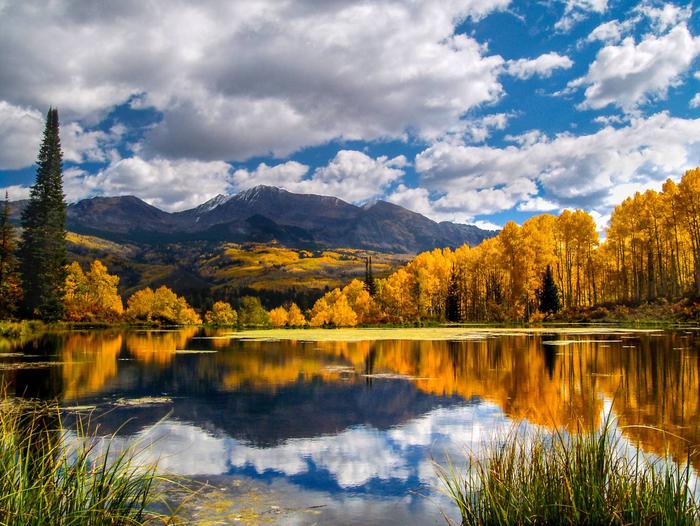
Grand Mesa, Uncompahgre and Gunnison National Forest
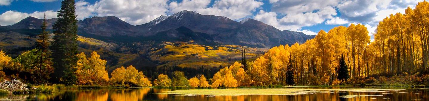

It’s the Geography – Plateaus to Peaks
Grand Mesa, Uncompahgre, and Gunnison National Forests offer scenery and an abundance of opportunities for outdoor recreation. Over three thousand miles of trails and routes provide access to areas of rugged beauty and solitude. Many were carved by indigenous peoples, early explorers, and miners, and offer an experience that connects users to the land and to the past. The mountains, plateau, and mesa that make up the forest will always provide a scenic backdrop and thus a component of the quality of life in the area.
We invite you to visit our forest and enjoy the beauty, history and challenges it has to offer. Recreation, motor vehicle and quad maps are available. View a Ranger District location map.
Use the sidebar menu on the left to search for recreation areas by activity or use the sidebar menu on the right to search by area.
To make reservations at the concession operated campgrounds please visit www.recreation.gov or call 1-877-444-6777
RecAreaDirections
Open with Google Map
Misc
| Stay Limit | |
| Reservable | false |
| Keywords | |
| Map Link | |
| Contact Phone | |
| Contact Email |
Permits info
Facilities
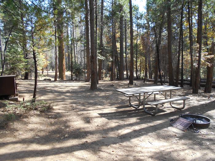
Silver Jack Campground (CO) Campground
List of CampsitesOverview
Silver Jack Campground has 60 campsites around three loops - Chipeta, Ouray and Sapinero. Each loop is heavily wooded with Aspen and a few spruce trees and an understory of tall grass and wildflowers. The campground is convenient to the Silver Jack Reservoir and a network of trails around the Cimarron Ridge. One of the three loops is often used for groups while the other two are for individual campers. Drinking water is available. There are no close communities to get provisions so visitors need to bring everything they need. This is bear country; practice safe food storage techniques.
Facilities
The campground offers single-family sites, each equipped with a picnic table and campfire ring. Some sites are handicap accessible.
Nearby Attractions
There are OHV trails nearby
Almont Campground
List of CampsitesOverview
This location is available on a first-come, first-served basis only. Visitors are required to physically arrive at the campground to purchase and claim a site. Once on-site, you may be able to pay for your campsite(s) by scanning a QR code using the Recreation.gov mobile app, and the Scan and Pay feature.
If this option is available, you will need to first download the free Recreation.gov mobile app https://www.recreation.gov/mobile-app prior to your arrival as some remote areas have limited or no cellular service.
Beaver Lake (CO) Campground
List of CampsitesOverview
This location is available on a first-come, first-served basis only. Visitors are required to physically arrive at the campground to purchase and claim a site. Once on-site, you may be able to pay for your campsite(s) by scanning a QR code using the Recreation.gov mobile app, and the Scan and Pay feature.
If this option is available, you will need to first download the free Recreation.gov mobile app https://www.recreation.gov/mobile-app prior to your arrival as some remote areas have limited or no cellular service.
Big Cimarron Campground
List of CampsitesOverview
This location is available on a first-come, first-served basis only. Visitors are required to physically arrive at the campground to purchase and claim a site. Once on-site, you may be able to pay for your campsite(s) by scanning a QR code using the Recreation.gov mobile app, and the Scan and Pay feature.
If this option is available, you will need to first download the free Recreation.gov mobile app https://www.recreation.gov/mobile-app prior to your arrival as some remote areas have limited or no cellular service.
Big Creek (CO) Campground
List of CampsitesOverview
This location is available on a first-come, first-served basis only. Visitors are required to physically arrive at the campground to purchase and claim a site. Once on-site, you may be able to pay for your campsite(s) by scanning a QR code using the Recreation.gov mobile app, and the Scan and Pay feature.
If this option is available, you will need to first download the free Recreation.gov mobile app https://www.recreation.gov/mobile-app prior to your arrival as some remote areas have limited or no cellular service.
Cement Creek Campground
List of CampsitesOverview
This location is available on a first-come, first-served basis only. Visitors are required to physically arrive at the campground to purchase and claim a site. Once on-site, you may be able to pay for your campsite(s) by scanning a QR code using the Recreation.gov mobile app, and the Scan and Pay feature.
If this option is available, you will need to first download the free Recreation.gov mobile app https://www.recreation.gov/mobile-app prior to your arrival as some remote areas have limited or no cellular service.
Cold Spring (CO) Campground
List of CampsitesOverview
This location is available on a first-come, first-served basis only. Visitors are required to physically arrive at the campground to purchase and claim a site. Once on-site, you may be able to pay for your campsite(s) by scanning a QR code using the Recreation.gov mobile app, and the Scan and Pay feature.
If this option is available, you will need to first download the free Recreation.gov mobile app https://www.recreation.gov/mobile-app prior to your arrival as some remote areas have limited or no cellular service.
Cottonwood Lake (CO) Campground
List of CampsitesOverview
This location is available on a first-come, first-served basis only. Visitors are required to physically arrive at the campground to purchase and claim a site. Once on-site, you may be able to pay for your campsite(s) by scanning a QR code using the Recreation.gov mobile app, and the Scan and Pay feature.
If this option is available, you will need to first download the free Recreation.gov mobile app https://www.recreation.gov/mobile-app prior to your arrival as some remote areas have limited or no cellular service.
Crag Crest Campground
List of CampsitesOverview
This location is available on a first-come, first-served basis only. Visitors are required to physically arrive at the campground to purchase and claim a site. Once on-site, you may be able to pay for your campsite(s) by scanning a QR code using the Recreation.gov mobile app, and the Scan and Pay feature.
If this option is available, you will need to first download the free Recreation.gov mobile app https://www.recreation.gov/mobile-app prior to your arrival as some remote areas have limited or no cellular service.
Deer Lakes (CO) Campground
List of CampsitesOverview
This location is available on a first-come, first-served basis only. Visitors are required to physically arrive at the campground to purchase and claim a site. Once on-site, you may be able to pay for your campsite(s) by scanning a QR code using the Recreation.gov mobile app, and the Scan and Pay feature.
If this option is available, you will need to first download the free Recreation.gov mobile app https://www.recreation.gov/mobile-app prior to your arrival as some remote areas have limited or no cellular service.
Erickson Springs Campground
List of CampsitesOverview
This location is available on a first-come, first-served basis only. Visitors are required to physically arrive at the campground to purchase and claim a site. Once on-site, you may be able to pay for your campsite(s) by scanning a QR code using the Recreation.gov mobile app, and the Scan and Pay feature.
If this option is available, you will need to first download the free Recreation.gov mobile app https://www.recreation.gov/mobile-app prior to your arrival as some remote areas have limited or no cellular service.
Gothic Campground
List of CampsitesOverview
This location is available on a first-come, first-served basis only. Visitors are required to physically arrive at the campground to purchase and claim a site. Once on-site, you may be able to pay for your campsite(s) by scanning a QR code using the Recreation.gov mobile app, and the Scan and Pay feature.
If this option is available, you will need to first download the free Recreation.gov mobile app https://www.recreation.gov/mobile-app prior to your arrival as some remote areas have limited or no cellular service.
Little Bear Campground
List of CampsitesOverview
This location is available on a first-come, first-served basis only. Visitors are required to physically arrive at the campground to purchase and claim a site. Once on-site, you may be able to pay for your campsite(s) by scanning a QR code using the Recreation.gov mobile app, and the Scan and Pay feature.
If this option is available, you will need to first download the free Recreation.gov mobile app https://www.recreation.gov/mobile-app prior to your arrival as some remote areas have limited or no cellular service.
Mosca Campground
List of CampsitesOverview
This location is available on a first-come, first-served basis only. Visitors are required to physically arrive at the campground to purchase and claim a site. Once on-site, you may be able to pay for your campsite(s) by scanning a QR code using the Recreation.gov mobile app, and the Scan and Pay feature.
If this option is available, you will need to first download the free Recreation.gov mobile app https://www.recreation.gov/mobile-app prior to your arrival as some remote areas have limited or no cellular service.
North Bank (CO) Campground
List of CampsitesOverview
This location is available on a first-come, first-served basis only. Visitors are required to physically arrive at the campground to purchase and claim a site. Once on-site, you may be able to pay for your campsite(s) by scanning a QR code using the Recreation.gov mobile app, and the Scan and Pay feature.
If this option is available, you will need to first download the free Recreation.gov mobile app https://www.recreation.gov/mobile-app prior to your arrival as some remote areas have limited or no cellular service.
Pitkin Campground
List of CampsitesOverview
This location is available on a first-come, first-served basis only. Visitors are required to physically arrive at the campground to purchase and claim a site. Once on-site, you may be able to pay for your campsite(s) by scanning a QR code using the Recreation.gov mobile app, and the Scan and Pay feature.
If this option is available, you will need to first download the free Recreation.gov mobile app https://www.recreation.gov/mobile-app prior to your arrival as some remote areas have limited or no cellular service.
Quartz Campground
List of CampsitesOverview
This location is available on a first-come, first-served basis only. Visitors are required to physically arrive at the campground to purchase and claim a site. Once on-site, you may be able to pay for your campsite(s) by scanning a QR code using the Recreation.gov mobile app, and the Scan and Pay feature.
If this option is available, you will need to first download the free Recreation.gov mobile app https://www.recreation.gov/mobile-app prior to your arrival as some remote areas have limited or no cellular service.
Rivers End Campground
List of CampsitesOverview
This location is available on a first-come, first-served basis only. Visitors are required to physically arrive at the campground to purchase and claim a site. Once on-site, you may be able to pay for your campsite(s) by scanning a QR code using the Recreation.gov mobile app, and the Scan and Pay feature.
If this option is available, you will need to first download the free Recreation.gov mobile app https://www.recreation.gov/mobile-app prior to your arrival as some remote areas have limited or no cellular service.
Snowblind Campground
List of CampsitesOverview
This location is available on a first-come, first-served basis only. Visitors are required to physically arrive at the campground to purchase and claim a site. Once on-site, you may be able to pay for your campsite(s) by scanning a QR code using the Recreation.gov mobile app, and the Scan and Pay feature.
If this option is available, you will need to first download the free Recreation.gov mobile app https://www.recreation.gov/mobile-app prior to your arrival as some remote areas have limited or no cellular service.
Soap Creek Campground
List of CampsitesOverview
This location is available on a first-come, first-served basis only. Visitors are required to physically arrive at the campground to purchase and claim a site. Once on-site, you may be able to pay for your campsite(s) by scanning a QR code using the Recreation.gov mobile app, and the Scan and Pay feature.
If this option is available, you will need to first download the free Recreation.gov mobile app https://www.recreation.gov/mobile-app prior to your arrival as some remote areas have limited or no cellular service.
Spring Creek (CO) Campground
List of CampsitesOverview
This location is available on a first-come, first-served basis only. Visitors are required to physically arrive at the campground to purchase and claim a site. Once on-site, you may be able to pay for your campsite(s) by scanning a QR code using the Recreation.gov mobile app, and the Scan and Pay feature.
If this option is available, you will need to first download the free Recreation.gov mobile app https://www.recreation.gov/mobile-app prior to your arrival as some remote areas have limited or no cellular service.
Spruce Grove (CO) Campground
List of CampsitesOverview
This location is available on a first-come, first-served basis only. Visitors are required to physically arrive at the campground to purchase and claim a site. Once on-site, you may be able to pay for your campsite(s) by scanning a QR code using the Recreation.gov mobile app, and the Scan and Pay feature.
If this option is available, you will need to first download the free Recreation.gov mobile app https://www.recreation.gov/mobile-app prior to your arrival as some remote areas have limited or no cellular service.
Sunshine Campground
List of CampsitesOverview
This location is available on a first-come, first-served basis only. Visitors are required to physically arrive at the campground to purchase and claim a site. Once on-site, you may be able to pay for your campsite(s) by scanning a QR code using the Recreation.gov mobile app, and the Scan and Pay feature.
If this option is available, you will need to first download the free Recreation.gov mobile app https://www.recreation.gov/mobile-app prior to your arrival as some remote areas have limited or no cellular service.
Ward Lake Campground
List of CampsitesOverview
This location is available on a first-come, first-served basis only. Visitors are required to physically arrive at the campground to purchase and claim a site. Once on-site, you may be able to pay for your campsite(s) by scanning a QR code using the Recreation.gov mobile app, and the Scan and Pay feature.
If this option is available, you will need to first download the free Recreation.gov mobile app https://www.recreation.gov/mobile-app prior to your arrival as some remote areas have limited or no cellular service.
Weir and Johnson Campground
List of CampsitesOverview
This location is available on a first-come, first-served basis only. Visitors are required to physically arrive at the campground to purchase and claim a site. Once on-site, you may be able to pay for your campsite(s) by scanning a QR code using the Recreation.gov mobile app, and the Scan and Pay feature.
If this option is available, you will need to first download the free Recreation.gov mobile app https://www.recreation.gov/mobile-app prior to your arrival as some remote areas have limited or no cellular service.
Williams Creek (CO) Campground
List of CampsitesOverview
This location is available on a first-come, first-served basis only. Visitors are required to physically arrive at the campground to purchase and claim a site. Once on-site, you may be able to pay for your campsite(s) by scanning a QR code using the Recreation.gov mobile app, and the Scan and Pay feature.
If this option is available, you will need to first download the free Recreation.gov mobile app https://www.recreation.gov/mobile-app prior to your arrival as some remote areas have limited or no cellular service.
Woods Lake Campground
List of CampsitesOverview
This location is available on a first-come, first-served basis only. Visitors are required to physically arrive at the campground to purchase and claim a site. Once on-site, you may be able to pay for your campsite(s) by scanning a QR code using the Recreation.gov mobile app, and the Scan and Pay feature.
If this option is available, you will need to first download the free Recreation.gov mobile app https://www.recreation.gov/mobile-app prior to your arrival as some remote areas have limited or no cellular service.
MATTERHORN CABIN Campground
List of CampsitesOverview
The Matterhorn Cabin is a great destination for anything from a family reunion to a week-long ski trip. This modern facility offers comfortable accommodations for groups of 12 or more and is available during the fall and winter months. Located just off the highway, it is easily accessible by passenger cars and is only 15 miles from the town of Telluride.Recreation
Ski right from the cabin door onto groomed cross-country ski trails! Neighboring the cabin is a groomed cross-country ski area that offers 10 kilometers of groomed trails for classic skiing, skate skiing and snowshoeing.The Telluride Ski Area is just a 15-minute drive from the cabin, offering world-class skiing and snowboarding. Snowmobilers will enjoy riding the Lizard Head meadows (three miles away) or riding groomed trails in the nearby Alta Lakes area. Local guide services offer heli-skiing, snowmobiling, backcountry skiing, dog sledding and ice climbing trips.
Facilities
This 1,800-square foot cabin has electricity, running water, a furnace, woodstove and washer/dryer. It comfortably sleeps 12 people in the five bedrooms (two twin bunk beds/mattresses each) and upstairs TV room (two double sleeper couches). The kitchen has two refrigerators, two electric ovens, one microwave oven, cookware, coffee maker, dishes and utensils. The two bathrooms each have flush toilets and showers. There is a land line phone in the cabin. Cell phone reception is unreliable. Cleaning supplies, garbage bags, toilet paper, dish soap and sponges, firewood, and a garbage dumpster are provided.Bring food, sleeping bags, bed pillows, bath towels and toiletries.
Natural Features
Visitors can expect a large facility set back roughly 100 feet from the road within a forested setting. Guests will have a prominent view of Sheep Mountain (13,188 feet) from the front porch.contact_info
This location has limited staffing. Please call (970) 729-2307 for general information.Nearby Attractions
Nearby winter attractions include the Telluride Ski Area, Lizard Head Wilderness and the resort towns of Telluride and Mountain Village.LONE CONE CABIN Campground
List of CampsitesOverview
The Lone Cone Cabin is a great destination for an overnight getaway or a week-long hunting trip. Located just 24 miles from Norwood, Colorado, the facility can be accessed in the summer and fall by passenger vehicle or 4WD, depending on conditions.Recreation
It is just a short walk to the Lone Cone Trailhead where hikers and equestrians can gain access to the Lizard Head Wilderness. The cabin is within the heart of quality big game hunting terrain. Off-highway vehicle enthusiasts will find a large network of forest roads to ride.Summer: The large meadow surrounding the cabin is ideal for family gatherings and weddings. Additional mountain biking, motorcycling, hiking, equestrian and fishing opportunities can be found right out the door of the cabin or by driving just 15-20 miles to the Woods Lake Recreation Area or to Miramonte Reservoir State Wildlife Area. Opportunities abound for mushroom-picking and watching wildlife.
Facilities
The cabin is equipped with a refrigerator, electric oven/range, a woodstove, cleaning supplies, cookware, dishes, and utensils. There are two bedrooms; one with two bunkbeds, and the other room has a queen bed. The cabin has one flush toilet, a shower, and a fully equipped kitchen (i.e. electric stove, microwave, refridgerator, plates, silverware, cookware, etc.). Keep in mind that if the power goes out to the cabin (happens regularly during wind storms), there is no water. Please come prepared for this possibility. A horse corral with feed bunk and water trough is provided 150 yards south of the cabin. You must bring your own certified weed-free hay.
In addition to bringing extra water; bring food, bedding (beds have mattress covers), warm clothing, flashlights, towels and toiletries. Please pack out your trash. Trash bags, toilet paper, and cleaning supplies are provided on site.
Natural Features
The cabin sits in a large secluded meadow at 9,200 feet elevation, surrounded by an aspen and spruce forest. Guests will have an excellent view of Colorado sunsets and the Lone Cone Peak from the front porch. The night sky is very dark here. You'll likely see the milky way on a clear night!
contact_info
For facility specific information, please call (970) 729-2307.DINNER STATION Campground
List of CampsitesOverview
Dinner Station, a historic stop along an old stagecoach route from Aspen, is located in the Upper Taylor Park area, next to the Taylor River. The campground is a favorite among off-road and mountain biking enthusiasts.Recreation
The Taylor River can be accessed from within the campground. Anglers cast for rainbow and brook trout.A number of off-road trails are found in the surrounding area, including Doctor Park Trail, Taylor River Trail and Taylor Vista Trail.
Facilities
The campground offers single-family campsites, each equipped with a picnic table and campfire ring. Vault toilets, drinking water and trash collection are provided.Natural Features
The campground is nestled among ponderosa and lodgepole pine trees, at the edge of a broad, flat valley dotted with sagebrush. Most campsites are situated with the Taylor River on one side and open views of the Sawatch Mountains on the other side.Nearby Attractions
Taylor Park Reservoir is less than five miles from the campground, offering boating, fishing and swimming opportunities. A boat ramp and boat rentals are available there.LAKE IRWIN Campground
List of CampsitesOverview
Lake Irwin Campground is situated on the western banks of its picturesque namesake lake, approximately 9 miles from Crested Butte, Colorado. Visitors enjoy the area for its abundant trail opportunities, fishing and beautiful scenery.Recreation
Mountain biking and hiking are popular activities in this challenging, rugged terrain. Canoeing and fishing are favorite pastimes as well. The lake is usually so full of fish, one can see them rise to the calm surface.Facilities
The campground offers several single-family campsites, some of which are accessible. Each site is equipped with a picnic table and campfire ring. Drinking water is provided.
Natural Features
The campground is set high in the Colorado Rockies at an elevation of 10,200 feet. Summer days are cool and afternoon showers are common. Nights can be chilly.Lake Irwin borders the campground on the east, and the Ruby Mountain Range lies to the west. Vivid wildflowers fill the landscape during July and August. Most campsites are shaded by mature Englemann spruce and subalpine fir trees.
The Grand Mesa, Uncompahgre and Gunnison National Forests are located on the western slope of the Rocky Mountains. Together, the three forests cover 2.9 million acres in the central and southern Rocky Mountains, south of the Colorado River and west of the Continental Divide.
Nearby Attractions
The charming town of Crested Butte is a short drive from the campground. The former coal mining town offers a variety of outdoor activities, dining and shopping options and annual festivals, like the Crested Butte Wildflower Festival.Lakeview Gunnison Campground
List of CampsitesOverview
Lakeview Campground is located on Taylor Park Reservoir, at an elevation of 9,400 feet. Visitors enjoy the area for its fishing and boating, and abundant off-road and biking opportunities.Recreation
Taylor Park Reservoir offers boating, fishing and swimming. Anglers cast for northern pike, kokanee salmon, and rainbow, brown, brook and cutthroat trout. A boat ramp is located just below the campground. Fishing and pontoon boat rentals are available at the marina.A number of off-road trails are found in the surrounding area, including Doctor Park Trail, Taylor River Trail and Taylor Vista Trail.
Facilities
The campground offers several single-family campsites, some of which have electric hookups. Some sites are also accessible. Each site is equipped with a picnic table and campfire ring. Vault toilets, drinking water and trash collection are provided.Natural Features
The campground is situated just above Taylor Park Reservoir, among ponderosa and lodgepole pine trees. The valley floor is broad, flat and dotted with sagebrush. Most campsites have beautiful views of the reservoir and the Sawatch Mountains.Lodgepole (Taylor River Canyon near Gunnison, COLORADO) Campground
List of CampsitesOverview
Lodgepole Campground is located 22 miles from Gunnison, COLORADO in the Taylor River Canyon. Visitors enjoy the area for its rafting, fishing and trail opportunities.
Recreation
The Taylor River can be accessed from the campground, and offers a calm stretch for leisurely rafting and kayaking. Anglers cast for rainbow and brook trout.The Fossil Ridge Wilderness Area lies one mile south of the campground. The Summerville and South Lottis trailheads provide access to the scenic, natural area.
A number of off-road trails are found in the surrounding area, including Doctor Park Trail, Taylor River Trail and Taylor Vista Trail.
Facilities
The campground offers single-family campsites, each equipped with a picnic table and campfire ring. Vault toilets and drinking water are provided.Natural Features
The campground is situated in a dense stand of lodgepole pine trees, which provides shade and privacy between campsites. Summertime temperatures are warm during the day and cool at night.Nearby Attractions
Taylor Park Reservoir is located within 10 miles of the campground, offering boating, fishing and swimming. A boat ramp and boat rentals are available there as well.ONE MILE Campground
List of CampsitesOverview
One Mile Campground is located 18 miles from Gunnison, Colo.,f in the Taylor River Canyon. Visitors enjoy the area for its rafting, fishing and trail opportunities.Recreation
The Taylor River can be accessed from the campground, and offers a calm stretch for rafting and kayaking. Anglers cast for rainbow and brook trout.The Fossil Ridge Wilderness Area is nearby. The Summerville and South Lottis trailheads provide access to the scenic, natural area.
A number of off-road trails are found in the surrounding area, including Doctor Park Trail, Taylor River Trail and Taylor Vista Trail.
Facilities
The campground offers single-family campsites, all of which have electric hookups. Several sites are also accessible. Each site is equipped with a picnic table and campfire ring. Vault toilets and drinking water are provided.Natural Features
The campground lies on the banks of the Taylor River, at an elevation of 8,600 feet. Most sites are shaded by a stand of lodgepole pine and aspen trees. Summer temperatures are warm in the day and cool at night.Nearby Attractions
Taylor Park Reservoir is approximately 13 miles from the campground, offering boating, fishing and swimming opportunities. A boat ramp and boat rentals are available there as well.ROSY LANE Campground
List of CampsitesOverview
Rosy Lane Campground is located 17 miles from Gunnison, Colo., in the Taylor River Canyon. Visitors enjoy the area for its rafting, fishing and trail opportunities.Recreation
The Taylor River can be accessed from the campground, and offers a calm stretch for rafting and kayaking. Anglers cast for rainbow and brook trout.The Fossil Ridge Wilderness Area is nearby. The Summerville and South Lottis trailheads provide access to the scenic, natural area.
A number of off-road trails are found in the surrounding area, including Doctor Park Trail, Taylor River Trail and Taylor Vista Trail.
Facilities
The campground offers single-family campsites, each equipped with a picnic table and campfire ring. Site 008 has 15-Amp electric hookups. Site 004 is accessible.
Natural Features
The campground lies on the banks of the Taylor River, at an elevation of 8,600 feet. Most sites are shaded by a stand of lodgepole pine and aspen trees.Nearby Attractions
Taylor Park Reservoir is about 12 miles from the campground, with boating, fishing and swimming. A boat ramp and boat rentals are available.AMPHITHEATER (CO) Campground
List of CampsitesOverview
Amphitheater Campground is located near the town of Ouray, Colo., at an elevation of 8,400 feet. Visitors enjoy the area for its beautiful scenery and great hiking and off-road trail opportunities.Recreation
Many hiking trails are found in the immediate area, including the popular Upper Cascade Falls Trail, which begins at the campground. Baby Bath Tubs and Chief Ouray Mine trails can also be accessed from the same trailhead.The campground is a favorite among jeep and off-road enthusiasts for its close proximity to a number of exciting trails in the surrounding area.
Facilities
The campground offers single-family campsites, several of which are designated for tent camping only. Each site is equipped with a picnic table and campfire ring. Vault toilets, drinking water and trash collection are provided.Natural Features
The campground is named for the natural rock amphitheater that stands over Ouray. The massive gray cliffs were created by ancient volcanic and glacial activity. The campground is situated on the mountainside above Ouray, with stellar views of the amphitheater. A forest of Gambel oak trees and mixed conifers covers the area.Nearby Attractions
Ouray is known as America's Switzerland. The charming, historic, mountain town offers a variety of dining, shopping and lodging options, as well as a hot springs pool and a variety of annual festivals.JUMBO CAMPGROUND Campground
List of CampsitesOverview
Jumbo Campground is located on the northern slope of Colorado's Grand Mesa, in the Mesa Lakes area, which is home to over 300 lakes. Visitors enjoy the area for its great fishing, canoeing and hiking opportunities.Recreation
Jumbo and Sunset Lakes are open to non-motorized watercraft, making each a perfect place for canoeing and fishing. Anglers cast for brown, brook and rainbow trout. Numerous additional lakes in the area provide still more fishing and canoeing opportunities, as well as beautiful scenery.The West Bench Trail No. 501 is open to hiking, mountain biking and horseback riding. This popular path stretches several miles through the surrounding area.
Facilities
The campground offers single- and double-family campsites, most of which have electric hookups. A few single sites are accessible. Each site is equipped with a picnic table and campfire ring with grill. Vault toilets, drinking water and trash collection are provided.Natural Features
The campground is situated between Jumbo and Sunset Lakes along the Grand Mesa National Scenic and Historic Byway, at an elevation of 9,800 feet. A forest of mature spruce and aspen trees covers the area. Most sites have views of the lakes.A variety of wildlife, including deer and elk, frequents the area.
Nearby Attractions
The Grand Mesa National Scenic and Historic Byway offers 63 miles of scenic driving as it climbs from the rugged canyon floor, up to the forested mesa tops at 11,000 feet. The road passes sparkling lakes and meadows bursting with wildflowers. Many trailheads can be found along the byway.Grand Mesa Visitor Center is a short drive from the campground, at Island Lake. The center offers interpretive exhibits, a bookstore and a high-altitude wildflower garden containing over 50 native species.
The town of Cedaredge is 26 miles from the campground. It is home to Pioneer Town, a 19th Century village with frontier museums and more than 20 structures. A historic schoolhouse, blacksmith shop, saloon and jail can be seen in the town. Cedaredge's "Applefest" festival is held annually in October.
Moose Manor Cabin Campground
List of CampsitesOverview
Moose Manor at Mesa Lakes Recreation Area offers guests the opportunity to stay overnight in a traditional Forest Service ranger station. The original cabin was constructed in the 1930s, housing many rangers before it became a rental cabin.Located just 45 minutes from Grand Junction, the semi-rustic dwelling is convenient for hiking, mountain biking and fishing. From mid-August through October, guests can enjoy fall colors with extensive golden aspen stands surrounding the area. A large grass yard fronts the cabin, which is ideal for family gatherings and weddings.
Recreation
A popular mountain biking and horseback riding trail, West Bench Trail #501, connects the seven lakes of the Mesa Lakes Recreation Area. The cabin is also within walking distance to a carry-down boat ramp for canoeing and kayaking.Facilities
Moose Manor greets guests with a grassy lawn and a paved access road. Inside are cozy couches and a fireplace. Electricity is available and provides lighting and heat. A refrigerator, a shower, flush toilet and an electric cooking stove are among the features.The living and dining room comes with a table and chairs. Sleeping accommodations for six adults include one queen-size sofa sleeper and four twin-size beds. Air mattresses or cots can be brought in to accommodate two additional people for a total of eight guests. Kitchen equipment includes basic cooking and eating utensils.
Drinking water is available. Guests should bring food, bedding, a lighter or matches, trash bags, warm clothing, flashlights, dish cloths, dish soap and all basic camping gear. Click here for more cabin details.
Natural Features
Moose Manor in nestled in a stand of aspen and spruce trees at an elevation of 9,500 feet. Located on the north side of Grand Mesa National Forest, the cabin is in close proximity to several mountain lakes, including Sunset Lake and Jumbo Reservoir. Mesa Creek flows nearby.A variety of wildlife, including deer, elk, moose and bear, frequents the area.
Nearby Attractions
The Grand Mesa National Scenic and Historic Byway offers 63 miles of scenic driving as it climbs from the rugged canyon floor up to the forested mesa tops at 11,000 feet. The road passes sparkling lakes and meadows bursting with wildflowers. Many trailheads are found along the byway.Grand Mesa Visitor Center is a short drive away at Island Lake. The center offers interpretive exhibits, a bookstore and a high-altitude wildflower garden containing over 50 native species.
The town of Cedaredge, 26 miles from the campground, is home to Pioneer Town, a 19th-century village with frontier museums and over 20 structures housing a schoolhouse, blacksmith shop, saloon and jail. Cedaredge's Applefest is held annually in October.
Black Bear Cabin at Mesa Lakes (CO) Campground
List of CampsitesOverview
Black Bear Cabin at Mesa Lakes offers guests the opportunity to experience an overnight stay in a traditional Forest Service Ranger Station. The original Black Bear Cabin was constructed in the 1930s, where rangers worked for years overseeing the expansive forest.The cabin is about a 45-minute drive from Grand Junction area of western Colorado, and plenty of canoeing, mountain biking and fishing activities are within reach. From mid-August through October, guests can enjoy fall colors with extensive golden aspen stands surrounding the area. A large grass yard fronts the cabin, which can be used for family gatherings and weddings. This cabin is not ADA accessible.
Recreation
A popular mountain biking and horseback riding trail, West Bench Trail #501, connects the seven lakes of the Mesa Lakes Recreation Area. The cabin is also within walking distance to a carry-down boat ramp for canoeing and kayaking.The Grand Mesa Scenic Byway is well worth exploring. The byway passes near the cabin and offers 63 miles of scenery as it climbs from the rugged canyon floor up to the forested mesa tops at 11,000 feet. The road passes sparkling lakes and meadows bursting with wildflowers.
Facilities
The semi-rustic log cabin has a living area and bedroom on the main floor, and a bathroom with a flush toilet and shower is in the basement. The kitchen is equipped with a refrigerator and an electric stove. Electric lighting and heat are provided.Sleeping accommodations for five adults include queen size sofa sleeper and three twin size beds; air mattresses or cots can be brought in to accommodate three additional people for a total of eight guests. No RVs, campers, or tents allowed near facility to accommodate more people. Basic cooking and eating utensils, plates, knives, forks, spoons, cups, and basic pots and pans are furnished. Cleaning supplies are included as well.
Guests should bring bedding, warm clothes, food, a first aid kit, towels, dish soap and typical camping gear. Click here for more cabin details.
Natural Features
Black Bear is perched on a grassy lawn, partially shaded by large pines. Spruce, fir and aspen are among the surrounding trees. At an elevation of 9,500, the cabin is in close proximity to several mountain lakes, including Waterdog Reservoir and Jumbo Reservoir. Mesa Creek flows nearby.A variety of wildlife, including deer, elk and moose, frequents the area.
Nearby Attractions
Grand Mesa Visitor Center is a short drive away at Island Lake. The center offers educational exhibits, a bookstore and a high-altitude wildflower garden containing over 50 native species.The town of Cedaredge, 26 miles from the campground, is home to Pioneer Town, a 19th-century village with frontier museums and over 20 structures housing a schoolhouse, blacksmith shop, saloon and jail. Cedaredge's Applefest is held annually in October.
JACKSON GUARD STATION Campground
List of CampsitesOverview
Jackson Guard Station is a great destination for anything from a weekend getaway to a week-long hunting trip. The cabin was originally used as a guard station that housed Forest Service work crews. The cabin's access road is remarkably scenic, making for an impressive arrival.
In summer months, the cabin sets the stage for a wide array of activities. Recreation ranges from thrilling off-road vehicle riding to amazing scenery viewsing,hiking,and rewarding fishing.
Winter access is by snowmobile, cross country skiing or snowshoes,and fat bikes only along a 3.5-mile trail.
Recreation
Activities abound, with hiking, technical single track dirtbiking, ATV/OTV riding, snowshoing, cross country skiing. Hunting and fishing are popular in the area
Facilities
Visitors can expect a rustic cabin set back roughly 100 feet from the road, providing privacy and solitude. Amenities include wood stove. The kitchen includes cabinet space and some dishes are provided. The cabin has two bedrooms and four twin-size beds. A picnic table, campfire ring and vault toilet are located just outside the cabin.
No electricity or running water is available. Guests should bring drinking water, flashlights or lanterns, bedding, food, towels and toiletries.
In winter, kettles are provided to melt snow for water. A snow shovel and firewood is provided.
Natural Features
Situated near the southeast shores of Silver Jack Reservoir, Jackson Guard Station sits in a small aspen grove at 9,000 feet elevation. The cabin is at the base of High Mesa, near where the Cimarron River flows into the reservoir.Nearby Attractions
Nearby attractions include the San Juan Mountains, Alpine Plateau, Uncompahgre Wilderness, Silver Jack Reservoir and Black Canyon of the Gunnison National Park.
The cabin is about an hour's drive from Montrose or Ridgway, and an hour and a half from Gunnison.
ISLAND LAKE CAMPGROUND Campground
List of CampsitesOverview
Island Lake Campground is located at an elevation of 10,000 feet on Colorado's Grand Mesa, which is home to more than 300 fishing lakes, near the cities of Cedaredge and Delta. Visitors enjoy the area for its excellent fishing, canoeing and hiking opportunities.Recreation
More than 3,000 miles of trails and routes provide access to areas of rugged beauty and solitude. Many were carved by indigenous peoples, early explorers and miners, offering an experience that connects visitors to the land and its prehistoric and historic past.The topography allows the forest to provide year-round trails for beginners to experts. The mountains, plateau and mesa never fail to provide a breathtaking backdrop.
Facilities
The campground offers 39 sites, including electric, non-electric and group sites. Picnic tables and campfire rings are provided. Three vault restrooms are located within the facility.Trail access for hiking and off-road vehicle driving can be found within the campground. Visitors will find a boat ramp, fish cleaning station and new restroom at nearby Island Lake. Day-use parking and boat trailer parking are available for a small fee.
Natural Features
Island Lake is just .10 miles from the campground. A few sites offer panoramic views of Grand Valley and several lakes below. A dense grove of mature spruce trees covers most sites.A wide variety of wildlife frequents the area, including deer and elk.
Nearby Attractions
Recreation opportunities on the Grand Mesa National National Forest and surrounding areas are varied, and millions of visitors come to enjoy nearly 60 campgrounds and 13 picnic areas and more than 3,700 miles of system roads, including national and state-designated scenic byways and other scenic or recreation travel corridors.Thousands of miles of trails for hiking, snowmobiling, cross-country skiing, mountain biking and motorcycle riding are available, including sections of the Continental Divide National Scenic Trail and the Colorado Trail.
More than 300 lakes and 3,600 miles of streams are found on the Forest. Six mountain peaks reach more than 14,000 feet in elevation, creating many popular areas for rock and ice climbing, hiking and driving along high elevation meadows thick with colorful wildflowers and nature observation and photography of Colorado's abundant wildlife.
A variety of historic mining sites are also found in the forest, including the San Juan Mining area, as well as the Alpine Tunnel Historic District, which includes approximately 13 miles of the former Denver, South Park and Pacific Railroad railbed across the Continental Divide. The forest also contains three ski resorts, three lodges, two organizational camps and one marina.
MATTERHORN Campground
List of CampsitesOverview
Matterhorn Campground is located along the San Juan Skyway (Colorado Highway 145), near the quaint town of Telluride, at an elevation of 8,500 feet. Visitors enjoy the area for its beautiful scenery, hiking and off-road opportunities.Recreation
The Galloping Goose Trail #449 can be accessed from the campground. This 8.4-mile trail leads past a restored train trestle, over two trail bridges and along segments of the historic Rio Grande Southern Railway. The trail is open to hiking, biking and horseback riding.Many scenic driving routes, both paved and off-road, can be found in the area. Additional hiking trails crisscross the surrounding mountains. Lizard Head Wilderness is about 3 miles from the campground.
Facilities
The campground offers single-family sites, each equipped with a picnic table and campfire ring. Some sites are accessible and some have full RV hookups. Flush and vault toilets, drinking water, showers and trash collection are provided.Natural Features
Most sites on the outer edge of the campground are wooded. Sites on the inside are more open.Most sites have pleasant views, especially the walk-to tent sites, which have unobstructed and panoramic views of the surrounding mountains.
Nearby Attractions
The charming and historic town of Telluride is just 7miles away, offering dining and lodging options, live music, shopping, museums, galleries and plenty of summer activities.A free, scenic gondola connects Telluride with nearby Mountain Village, a small town with additional shopping and dining opportunities. On the gondola, visitors are awarded a panoramic view of the town and surrounding mountains.
COBBETT LAKE Campground
List of CampsitesOverview
Cobbett Lake Campground is located on Colorado's Grand Mesa, in the Land O' Lakes area, which is home to more than 300 lakes. Visitors enjoy the area for its great fishing, canoeing and hiking opportunities.Recreation
Cobbett Lake is open to non-motorized watercraft, making it a perfect place for canoeing and fishing. Anglers cast for rainbow, brook and cutthroat trout. Numerous additional lakes in the area provide more fishing and canoeing opportunities, as well as beautiful scenery.A variety of hiking trails, including the Cobbett Lake Trail and Grand Mesa Discovery Trail begin nearby. Several off-road vehicle trails are in the surrounding area.
Grand Mesa Visitor Center is within walking distance at Island Lake. The center offers interpretive exhibits, a bookstore and a high-altitude wildflower garden containing more than 50 native species.
Facilities
The campground offers single-family campsites, each equipped with a picnic table and campfire ring. Vault toilets, drinking water and trash collection are provided.Natural Features
The campground is situated along the Grand Mesa National Scenic and Historic Byway on the shore of Cobbett Lake, at an elevation of 10,300 feet. A dense grove of spruce trees covers the campground, offering shade in nearly every site.A variety of wildlife, including deer and elk, frequents the area.
Nearby Attractions
The Grand Mesa National Scenic and Historic Byway offers 63 miles of scenic driving as it climbs from the rugged canyon floor, up to the forested mesa tops, at 11,000 feet. The road passes sparkling lakes and meadows bursting with wildflowers. Many trailheads are found along the byway.The town of Cedaredge is 15 miles from the campground. It is home to Pioneer Town, a 19th Century village with frontier museums and more than 20 structures. A historic schoolhouse, blacksmith shop, saloon and jail can be visited there. Cedaredge's "Applefest" festival is held annually in October.
Aspen Leaf Cabin (Uncompahgre National Forest, Co) Campground
List of CampsitesOverview
Aspen Leaf is one of three cabins at the Cold Springs Work Center that welcomes guests with its homey vibe and remote mountain setting. Mountain biking and off-road vehicle trails are easily accessed here.The cabin was built in the 1930s for use by Forest Service employees. Vehicles can easily access the area, but a 4WD may be required in October, depending on weather conditions.
Recreation
The North Uncompahgre boasts an extensive ATV trail system known as the Divide Forks ATV complex. Over 50 miles of trails can be explored.Mountain bikers make use of the popular Tabaguache Trail System, and in fall, hunters frequent the area. Hiking and horseback riding are also enjoyable activities.
Facilities
This cabin has one bedroom and a bathroom with a flush toilet and shower. Sleeping accommodations include three twin-size beds and a queen sofa sleeper. Up to six guests may stay in this cabin, but extra cots and air mattresses are recommended.The kitchen includes a propane stove and refrigerator, plus basic cooking and eating utensils like plates, knives, forks and pots. Cleaning supplies are also provided.
Drinking water is supplied but the cabin does not have electricity. Guests should bring propane lanterns, matches, bedding, toilet paper, dish towels, warm clothing, paper towels and tools for gathering and cutting firewood. Click here for more cabin details.
No RVs, campers, or tents allowed.
Please conserve water. Water can be limited at times. Bring back-up drinking water.
Aspen Leaf Cabin is one of three cabins at the Cold Springs Work Center. One cabin may be occupied by Forest Service personnel.
Natural Features
Aspen Leaf Cabin sits in a field with scattered aspen and mountain shrub vegetation on the north end of the Uncompahgre National Forest. At 9,000 feet, the area offers crisp mountain air, mild days and chilly nights.Black bears, mountain lions, marmots and deer are among the wild inhabitants. Please be aware of bear safety.
Nearby Attractions
The nearest grocery store is in Grand Junction, 44 miles from the cabin.Anglers looking for lake fishing can head to Big Creek Reservoir, about 14 miles from the cabin.
OAK CABIN Campground
List of CampsitesOverview
Oak Cabin attracts outdoor enthusiasts ranging from mountain bikers to hunters to those who love riding off-road. The somewhat remote, semi-rustic cabin provides an ideal resting spot among aspen trees and mountain scenery.One of three cabins in the area, Oak Cabin was built in the 1930s for use by Forest Service employees at the Cold Springs Work Center. One of the other cabins may be occupied by Forest Service personnel. The area is easily accessed by vehicles, but a 4WD may be required in October, depending on weather conditions.
Recreation
The North Uncompahgre boasts an extensive ATV trail system known as the Divide Forks ATV complex. Over 50 miles of trails can be explored here.Mountain bikers make use of the popular Tabaguache Trail System, and in fall, hunters frequent the area. Hiking and horseback riding are also enjoyable activities.
Facilities
The single-story cabin, which sleeps four guests, has a small grassy lawn shaded by aspen trees. Furnishings include two twin-size beds in a bedroom, one queen sofa sleeper in the living room and one bathroom with a shower and flush toilet.The kitchen has a propane stove and refrigerator, plus basic cooking and eating utensils like plates, knives, forks and pots. Cleaning supplies are provided.
Drinking water is supplied but the cabin has no electricity. Guests should bring propane lanterns, matches, bedding, toilet paper, dish towels, warm clothing, paper towels, and tools for gathering and cutting firewood. Click here for more cabin details.
No RV’s, campers, or tents allowed.
Please conserve water. Water can be limited at times. Bring back-up drinking water.
Natural Features
Oak Cabin sits in a field with scattered aspen and mountain shrub vegetation on the north end of the Uncompahre National Forest. At 9,000 feet, the area offers crisp mountain air, mild days and chilly nights.Black bears, mountain lions, marmots and deer are among the wild inhabitants. Please be aware of bear safety.
Nearby Attractions
The nearest grocery store is in Grand Junction, which is 44 miles from the cabin.Anglers looking for lake fishing can head to Big Creek Reservoir, about 14 miles away.
SILESCA CABIN Campground
List of CampsitesOverview
The historic Silesca Cabin, once used as a Ranger Station, is a semi-rustic dwelling with comfortable modern conveniences like electricity and refrigerator. Located 40 minutes west of the city of Montrose, the cabin is set back 100 feet from the main road, providing easy access with some privacy.
The cabin is accessible in the summer and fall by passenger vehicle, when the road is dry. Four-wheel drive vehicles are recommended when the road is wet.
Recreation
Hiking, mountain biking, single track dirtbiking, UTV & ATV riding, horseback riding, hunting and wildlife viewing are all available in the vicinity. Silesca Pond is a short walk north of the cabin. Silesca Cabin is located near a limited hunting area for Rocky Mountain Elk, Unit 61.
Facilities
The rustic cabin accommodates up to six guests.
Amenities include three bedrooms with six twin beds, electricity, refrigerator and a wood stove. Limited cooking utensils, dishes and cleaning supplies are provided. The kitchen and bathroom are located in the basement of this cabin. A campfire ring and picnic table are located outside.
No drinking water is available. Items to bring include food, bedding, warm clothing, toilet paper, flashlights, towels, dish soap and toiletries. Click here for more cabin details.
Natural Features
The cabin is perched in a meadow surrounded by spruce and aspen trees at an elevation of 9,200 feet.
Grand Mesa, Uncompahgre and Gunnison National Forest Christmas Tree Permit Tree Permit
LOTTIS CREEK CAMPGROUND Campground
List of CampsitesOverview
Located in the Grand Mesa Uncompahgre and Gunnison National Forests, Lottis Creek Campground is at an elevation of 8,600 feet above sea level. On the shores of Lottis Creek, this newly remodeled campground is a perfect getaway for anyone that loves the outdoors. Nestled in lodgepole pines down the Taylor River Canyon, Lottis Creek Campground is great for anglers, hikers, bikers, and four-wheeler enthusiasts.Recreation
Two miles to the south, visitors will find access to the Fossil Ridge Wilderness Area. Hikers and equestrians can enjoy the trails of this pristine natural area. No mechanized or motorized vehicles are permitted in any Wilderness area. To the east of Lottis Creek Campground, four-wheel drivers will find many roads to explore. Cumberland Pass Road provides access to most of these trails.Facilities
There are 37 single family campsites. There is one group site accommodating 50 people and 10 vehicles with a group pavilion. This facility was completely renovated in 2012 with electric hookups at most sites. Each site is equipped with a picnic table and campfire ring.Natural Features
Many of the electric hookup campsites benefit from the shade provided by the lodgepole pines in the campground.Nearby Attractions
Taylor Park Reservoir is just a few miles from the campground, offering boating, fishing and swimming opportunities. A boat ramp and boat rentals are available there as well.â??Many trails for hikers are close by. Fishing is abundant in many areas and you will find numerous four-wheel drive trails.Cottonwood #1 Boat Launch - Grand Valley RD Facility
Gravel launch that allows you to back a trailer into the lake. There is one large rock in the water by the shoreline that must be straddled by trailer while backing.
Gunnison - Southeast Facility
Trails that are located east of Lake City and South of US 50
Rambouillet Snow #473 Facility
Rambouillet Snow Trail #473 is 4.5 miles long. It begins at Forest Road #729.1A and ends at the Gunnison National Forest boundary. The snow trail is open for the following uses: XC Skiing/Snowshoeing and Snowmobiling
Matterhorn Nordic Ski System Facility
This trail system offers 10 kilometers of nordic trails groomed by the Telluride Nordic Association for skate and classic skiing. The trails are on gentle, rolling terrain which is suitable for skiers of all abilities. Trail Map
Weir & Johnson Boat Launch- Grand Valley RD Facility
Lightly gravelled boat launch suitable for backing a trailer.
Campgrounds - Taylor Park Area Campground
List of CampsitesCampgrounds in Taylor Park Area
Wilson Peak Facility
Wilson Peak is a 14,017-foot peak in the Lizard Head Wilderness west of Telluride, Colorado. It is climbed by hundreds each year, primarily in the summer months, but winter ascents are not uncommon. Summer ascents via the southwest ridge route are considered Class 3 technical climbs, requiring scrambling over rock but ropes are typically not employed. The Rock of Ages trail (#429) offers the shortest route to Wilson Peak.
Brush Creek Winter Trailhead Facility
For a description of the area please call the Gunnison Ranger District at 970-641-0471
Lake City Facility
Southern part of Gunnison Ranger District
Cimarron Area Facility
Cimarron area of the San Juan Mountains (Ouray District)
Pitkin Facility
Camping east of Gunnison near Pitkin
La Garita Driveway Snow #547 Facility
The La Garita Driveway Snow Trail #547 is 2.0 miles long. It begins at Colorado State Highway 149 and ends at the Gunnison National Forest boundary. The snow trail is open for the following uses: XC Skiing/Snowshoeing and Snowmobiling
Old Highway 149 Snow #149 Facility
Old Highway 149 Snow Trail #149 is 2.3 miles long. It begins at Colorado State Highway 149 and ends at Forest Road #788.1F. The snow trail is open for the following uses: XC Skiing/Snowshoeing and Snowmobiling
Cow Creek Snow #114 Facility
Cow Creek Snow Trail #114 is 4.3 miles long. It begins at Forest Road #765 and ends at Forest Road #209. The snow trail is open for the following uses: XC Skiing/Snowshoeing and snowmobiling
Ward Way Picnic Site Facility
Fishing and hiking.
Telluride Area Facility
Telluride area of the San Juan Mountains (Norwood District). Telluride Trail Brochure
Quartz Creek Fishing Site Facility
A description is coming.
Other Sites - Ouray Area Facility
Sites other than campgrounds and trails in the Ouray area of the San Juan Mountains (Ouray District).
Commissary Trailhead Facility
Commissary Trailhead is a former campground area that provides parking for hikers and hunters during the summer and fall.
Fall's Wall Climbing Area Facility
For a description of this area please contact the Ouray Ranger District at 970-240-5300
San Juan Mountains Facility
This area includes the portion of the San Juan Mountains that are on the Norwood and Ouray Districts of the Uncompahgre National Forest. This area is also known as the Mountain Division.
McDonough Reservoir Day Use Area/Fishing Site Facility
A fishing area located near Cochetopa Dome
County Line Ski System Facility
The County Line Trails is located in the central portion of the Grand Mesa. The western access is off Highway 65 at the County Line Winter Trailhead. The trail receives frequent grooming a moderate level of difficulty. Trail miles total 7.8 miles and offers winter trail loop options in open coniferous forest. (Winter Trail Map)
Oil Well Mtn. Loop #522.1A Facility
The Oil Well Mountain Trail #522.1A begins on Forest Service Road #265.3D, intersects with the Grand Valley Ranger Districts the Burn Trail #522, and ends at the end of Forest Service Road #265.3A. The combination of these two trail and a section of CR 265 make a complete loop. The trail travels to the east through parks and scattered aspen. As it turns north it climbs through an aspen forest. After 3.5 miles it climbs a narrow ridge to the edge of Muddy Basin and then further on to The Burn. This area is scattered spruce and fir trees mixed into open parks. It begins to descend to the west toward Oil Well Mountain through aspen and comes out under the power line as it meets FSR 265.3A. Continue south on FSR 265.3A for almost a mile before turning west to rejoin CR 265.
Geo-Ref. Trail Map Geo-Reference Instructions
Erickson Springs Picnic Site Facility
Erickson Springs Recreation Area includes a picnic area with two picnic tables and a vaulted toilet. The tables sit on the bank of Anthricate Creek before entering the campground area.
Windy Point Spur Snow #243 Facility
Windy Point Spur Snow Trail #243.3M is 1.1 miles long. It begins at Forest Road #243.3H (Windy Peak Road) and ends at Forest Road #243.3B (Pipeline Road). The snow trail is open in the winter for the following uses: XC Skiing/Snowshoeing and Snowmobiling
Old Irwin Cemetery Facility
For a description of this area please call the Gunnison Ranger District at 970-641-0471.
Twin Lake Dispersed Area - Grand Valley RD Facility
10,300-foot elevation.
Crested Butte Facility
CB camping
Uncompahgre Plateau Facility
This area includes the Uncompahgre Plateau area of Norwood, Ouray, and Grand Valley Districts on the Uncompahgre National Forest. It is also know as the Plateau Division.
Texas Creek Horse Trailhead Facility
For a description of the area please call the Gunnison Ranger District at 970-641-0471
Gunnison Facility
Recreation sites within the Gunnison Geographic area
Ouray Area Facility
Ouray Area of the San Juan Mountains (Ouray District).
Five-mile Day Use Area Facility
This day use areas is located along the Taylor River in the Gunnison Ranger District.
Griffith Ski Loop Facility
A description is coming soon.
Other Sites - Telluride Area Facility
Sites other than campgrounds and trails in the Telluride area of the San Juan Mountains (Norwood District).
Powderhorn Wilderness Facility
Powderhorn Wilderness is located 10 miles northeast of Lake City, Colorado and occupies 61,915 acres. The southern one-fourth of the Wilderness is managed by Gunnison National Forest (13,935 acres), and the northern three-fourths by the Bureau of Land Management. Elevations range from 8,699’ in the north to 12,600' in the south.
In this Wilderness the northern verge of the San Juan Mountains reaches out into the Gunnison Basin, a dry land of sagebrush meadows strewn with fish-filled lakes, including Powderhorn Lakes. Worn by glaciation, the Cannibal and Calf Creek Plateaus contain one of the largest, least disturbed, and relatively flat alpine tundra areas in the contiguous United States. Elk and mule deer roam the plateaus and pass through the stands of aspen, pine, spruce, and fir that blanket the lower elevations.
Trails include the Powderhorn Lakes, East Fork, Powderhorn Park, North Calf Creek, Canyon Inferno and Devil's Creek trails.
Always use Leave No Trace techniques to help keep this area wild, clean, and pristine.
Ajax Peak Facility
Ajax Peak is a nontechnical peak climb close to Telluride, CO that offers 360-degree views from its 12,785-foot summit. It is a fairly arduous hike, gaining over 2400 feet in elevation when started from the Valley View Parking Area at the base of Forest Road #638.
Twilight Parking Area Facility
This is a paved parking area near the Grand Mesa Visitor Center.
North Fork Valley - Paonia District Facility
This area is around the North Fork of the Gunnison River.
Fruita Picnic Site Facility
Toilet, tables and fire rings.
Grand Mesa Facility
Largest flat top mountain in the world.
Fish Your National Forests: This site can be accessed by Passenger Car; Fish available include: Trout; Types of fishing available include: Wade, Motorized boat, Float tube, Fly, Ice; ADA Accessible fishing access with fishing pier and boat launch
Soap Creek Facility
Various recreation sites in the Soap Creek Area
Hoodoo Gap #877 Facility
The Hoodoo Gap Trail #877 begins at an intersection with the Curecanti Trail #870 at the West Elk Wilderness boundary and ends just past Hoodoo Gap. After leaving the Curecanti Trail, the Hoodoo Gap Trail begins a moderate climb to the southeast through aspen forest, crossing Spruce Creek and Hoodoo Creek along the way. The trail does not get a lot of use and is sometimes difficult to follow. Most of the trail is located in aspen trees with few views of the surrounding mountains. It is a good access to Mount Gunnison for those that wish to climb the 12,719 foot peak. After reaching Hoodoo Gap, the trail breaks up into several game trails that can lead a person farther into the Wilderness.
Geo-Ref Trail Map Geo-Reference Instructions
Piburn #880 Facility
The Piburn Trail #880 begins at Forest Service Road #814.1G and ends at an intersection with the Curecanti Trail #870. It is a lightly used trail that begins as an old 4-wheel drive road. It is access to an irrigation ditch and then turns into a regular trail. In the first 5 miles there are a series of casual rises and falls in terrain running through mostly aspen forests with some spruce and fir trees. Then the trail climbs sharply up a series of narrow switchbacks. At the 5.5 mile point you are on an open ridge with spectacular views. At 6 miles, the Bald Mountain Tie-in Trail #882 joins the Piburn Trail then it continues east for one mile to join the Curecanti Trail #870. The Piburn Trail #880 is usually open by early July with many loop type trips possible.
Geo-Ref Trail Map Geo-Reference Instructions
Kroenke Lake #448 Facility
Kroenke Lake Trail #448 is 0.9 miles long. It begins at Forest Trail #369 and ends at the Gunnison National Forest boundary. The trail is open for the following uses: Hiking, Horseback Riding
Surface Creek Snowmobile #741 Facility
The Surface Creek Snowmobile Trail #741 begins at the Surface Creek Winter Trailhead approximately ¾ of a mile south of the National Forest boundary and ends at an intersection with the Sunlight to Powderhorn Trail (SP). On the Sunlight to Powderhorn Trail map the Surface Creek Trail is #27. This trail runs north following Forest Service Road 125 to where it ties into the SP Trail near Trickle Park Reservoir and Forest Service Road 121. It climbs through aspen to spruce/fir timber into open parks at elevations from 8,600 feet to 10,100 feet. Because this trail is groomed and follows a roadway it is good for all skill levels.
Cannibal Plateau #464 Facility
Forest Trail #464 (Cannibal Plateau Trail) is 5.1 miles long. It begins at Forest Road #788 and ends at a dead end. The trail is open for the following uses: hiking, mountain biking, horseback riding, motorcycle trail riding, ATV trail riding, and Off Highway Vehicles (OHV) less than or equal to 50 inches wide
Napoleon Pass #540 Facility
The Napoleon Pass trail is 1.4 miles long. It begins at Forest Road 765 and ends at Gunnison Ranger District Boundary. The trail is open for the following uses: Hiking, and Off Highway Vehicles (OHV) less than or equal to 50 inches wide
Willow Mine #611 Facility
Forest Trail #611 (Willow Mine Trail) is 0.8 miles long. It begins at Forest Road #882.1C (Willow Creek Mine Road) and ends at Forest Trail #610 (Bear Gulch Trail). Forest Trail #611 is open for the following uses: Hiking, Mountain Biking, Horseback Riding, Motorcycle Trail Riding
Agate Spur #484.2A Facility
Forest Trail #484.2A (Agate Spur Trail) is 0.6 miles long. It begins at U.S. Highway 50 (T. 48 N. R. 5 E. Section 6) and ends at Forest Trail #484 (T48N R5E Section 6). Forest Trail #484.2A is open for the following uses: hiking, mountain biking, horseback riding, motorcycle trail riding
Paradox #502 Facility
The Paradox Trail #502 begins at the end of Forest Service Road #660, Pinto Mesa Road, and ends at the National Forest Boundary. The trail starts west, then northwest and descend off Pinto Mesa. After about 0.4, it turn southeast and at about 1 miles it veer to the southwest as it wanders its way toward Coal Canyon. It ends at the National Forest Boundary which is also the edge of the Tabeguache Area.
Geo-Ref Trail Map Geo-Reference Instructions
Middle Barrett Creek #494 Facility
Forest Trail #494 (Middle Barrett Creek Trail) is 4.5 miles long. It begins at Forest Road #782 (T48NR3E Section 36) and ends at Forest Trail #493 (T47NR4E Section 30). Forest Trail #494 is open for the following uses: Hiking, Mountain Biking, Horseback Riding, Motorcycle Trail Riding, and ATV Trail Riding
Weehawken #206 Facility
The Weehawken Trail #206 begins at County Road 361 and ends at Weehawken Creek. The trail switchbacks as it climbs through aspen forests and open meadows. There are spectacular views of Hayden Mountain, raising 13,139 feet. It intersects the Alpine Mine Trail #206.1A after approximately 1.3 miles, stay left to continue on the Weehawken Trail. The trail ascends and descends as it continues into the Weehawken valley with views of waterfalls, alpine meadows, wild flowers and canyon walls of volcanic rock. At approximately 2.7 miles, it reaches a basin and then enters forest where it follows a gorge until it ends at Weehawken Creek.
Ridge #221.1B Facility
The Ridge trail is 1.5 miles long. It begins at Forest Trail #221 and ends at De. The trail is open for hiking & horseback riding.
Paradox #126 Facility
The Paradox Trail #126 begins at Forest Service Road #535, Paradox Road, and ends at an intersection with the Spring Creek Trail #116. The trail mostly descends through aspen groves with nice views to the northeast. At about 2.4 miles it crosses West Fork Spring Creek and continues east. In about another 0.8 miles it turns south continuing below a ridgeline on the west and above the Middle Fork Spring Creek drainage on the east. In another 2.2 miles it intersects the Spring Creek Trail.
Geo-Ref Trail Map Geo-Reference Instructions
Spruce #221.1A Facility
Forest Trail #221.1A (Spruce Trail) is 1.2 miles long. It begins at Forest Trail #221 (Nate Trail) and ends at Forest Road #858 (Owl Creek - Cimarron Road). Forest Trail #221.1A is open for hiking & horseback riding.
Twin Lakes Spur #402.1A Facility
Forest Trail #402.1A (Twin Lakes Spur Trail) is 0.6 miles long. It begins at Forest Road #738 (Brush Creek Road) and ends at the Maroon Bells - Snowmass Wilderness boundary. The trail is open for the following uses: Hiking, Horseback Riding
Sun Park #444 Facility
Forest Trail #444 (Sun Park Trail) is 2.2 miles long. It begins at Forest Trail #449 (Rainbow Lake Trail) and ends at Forest Trail #464 (Beaver Creek Trail). The trail is open for the following uses: Hiking, Horseback Riding
Simms Mesa #115 Facility
The Simms Mesa Trail #115 begins at Forest Service Road #510, Dave Wood Road, and ends at Forest Service Road #574, Simms Mesa Road. It the first half mile the trail crosses a draw and then wanders across Happy Canyon. After about 1.6 miles, it descends into the Happy Canyon Creek drainage and crosses Happy Canyon Creek. The trail ends at FSR #574 in about another half a mile.
Geo-Ref Trail Map Geo-Reference Instructions
Picket Corral #102 Facility
The Picket Corral Trail #102 begins on Forest Service Road 501.1A and ends at Forest Service Road #500.4C. The trail descends into the East Fork Escalante Creek drainage and follows along the west side of the creek. It heads north, coming to an end at FSR 500.4C near the Picket Corral Ranch.
Geo-Ref Trail Map Geo-Reference Instructions
Yule Pass #576 Facility
Forest Trail #576 (Yule Pass Trail) is 2.2 miles long. It begins at Forest Road #734.4 and ends at the Gunnison National Forest boundary. The trail is open for the following uses: Hiking
Cabin Bench Area #104 Facility
The Cabin Bench Area Trail #104 begins at Forest Service Road #501 and ends at FSR #502. This trail travels along Cabin Bench above the East Fork Escalante Creek. A combination of this trail, FSR #502 and #501 creates about a 7.2 mile loop.
Geo-Ref Trail Map Geo-Reference Instructions
Miners Creek #785 Facility
Forest Trail #785 (Miners Creek Trail) is 0.5 miles long. It begins at the Gunnison National Forest boundary (T. 43 N. R. 2 E. Section 7) and ends at Forest Trail #784. Forest Trail #785 is open for the following uses: Hiking, and Horseback Riding
Sissy #716 Facility
The Sissy Trail #716 is most often used by people camping in the Weir & Johnson Campground who are interested in a quick and easy hike. The primary vegetation along this trail includes spruce and fir trees. Sissy Lake is a shallow lake and does not support any type of fish habitat.
Geo-Ref Trail Map Geo-Reference Instructions
Simms Mesa Loop Connector Hike #115.1A1 Facility
The Simms Mesa Loop Connector Trail #115.1A1 begins and ends at the Dave Wood Interpretive Trail #115.1A and interpretive sites 5-9 are located along this trail. The short connector trail travels east, climbs a gentle grade as it turns south, and hooks around to the north, gradually descending back to the Dave Wood Interpretive Trail. About a 1 miles loop can be accomplished by following the Dave Wood Interpretive Trail and the Simms Mesa Loop Connector from the Trailhead and back. Interpretive Trail Guide
Geo-Ref Trail Map Geo-Reference Instructions
Basin View #618 Facility
Forest Trail #618 (Basin View Trail) is 0.8 miles long. It begins at Forest Trail #531 and ends at Forest Road #237. Forest Trail #618 is open for the following uses: hiking, horseback riding. This trail is part of the Continental Divide National Scenic Trail.
Corduroy-Lujon #499 Facility
Forest Trail #499 (Corduroy-Lujon Trail) is 6.5 miles long. It begins at Saguache County Road NN14 and ends at Colorado State Highway 114. The trail is open for the following uses: hiking, mountain biking, horseback riding, and motorcycle trail riding
Old Owl Creek Spur B #236.1B Facility
Cimmaron area
Fairview #426 Facility
The Fairview trail is 2.3 miles long. It begins at Forest Trail 7427 and ends at Forest Road 770. The trail is open for the following uses: Hiking, Mountain Biking, Horseback Riding, and Motorcycle Trail Riding
Mesa Creek #505 Facility
The Mesa Creek Trail #505 begins at Hwy 65 and ends at an intersection with the West Bench Trail #501. There is an information Kiosk at the trail parking area that talks about the first sky runs on the Grand Mesa before Powderhorn, the old runs have never repopulated with trees and can still be seen. The trail starts out on an old two track, passing through aspen and open meadows. It descends to Mesa Creek and follows the creek most of its length, gradually climbing in elevation. It comes to an end when it intersects the West Bench Trail #501 near Sunset Lake.
Geo-Ref Trail Map Geo-Reference Instructions
Cobb's Gulch #211 Facility
Forest Trail #211 (Cobb's Gulch Trail) is 1.1 miles long. It begins at Forest Trail #216 and ends at the Forest boundary. The trail is open for hiking \& horseback riding.
Dutchman Creek #490 Facility
The Dutchman Creek trail is 6.0 miles long. It begins at Forest Road 750.2a and ends at Forest Trail 7486. The trail is open for the following uses: hiking, mountain biking, horseback riding, motorcycle trail riding, and ATV trail riding
Bear Gulch #610 Facility
Forest Trail #610 (Bear Gulch Trail) is 4.0 miles long. It begins at Forest Road #771 and ends at Forest Road #882. The trail is open for the following uses: hiking, mountain biking, horseback riding, motorcycle trail riding
Glacier Springs Cut-off #537 Facility
The Glacier Springs Cut-off Trail #537 begins at the Mesa Lakes Picnic Area/Glacier Trailhead and ends at an intersection with the Rim View Trail #533. This trail is a popular hiking trail as well as a winter cross country ski and snowshoe trail. It travels below the dam and passes through spruce/fir and aspen.
Geo-Ref Trail Map Geo-Reference Instructions
Taylor River #600 Facility
Forest River Trail #600 (Taylor River Trail) is 2.0 miles long. It begins at Forest Trail #424.5 and ends at Forest Road #742 (Taylor River Road). The trail is open for the following uses: Hiking, Mountain Biking, Horseback Riding, and Motorcycle Trail Riding
Upper Upper Loop #435.1A Facility
The Upper Upper Loop Trail #435.1A begins at County Road 738, Brush Creek Road, and ends at an intersection with the Upper Loop Trail #435. The trail begins a stiff climb through aspen forest which provide excellent colors in the fall. During the summer months, beautiful wildflowers are observed along the route. Both the Upper Upper Loop and the Wheatstone Vista Trails stay dryer during the year because of their lower elevation and southern exposure. Dogs on leash are also allowed.
Geo-Ref Trail Map Geo-Reference Instructions
Camp #476 Facility
Forest Trail #476 (Camp Trail) is 5.4 miles long. It begins at Hinsdale County Road 3 and ends at Rio Grande National Forest Trail #743 at the Gunnison National Forest boundary. Forest Trail #476 is open for the following uses: hiking, mountain biking, horseback riding
Red Canyon #118 Facility
The Red Canyon Trail #118 begins on Forest Service Road #549, State Draw Road, and ends at Forest Service Road #540, Old Highway 90. The trail mostly follows an old two track for the first 1.7 miles through a dense forest of spruce/fir, open meadows and aspen groves. In about 3.2 miles, it reaches the rim of Red Canyon and begins to switchback down the canyon towards Red Canyon Creek. After crossing the creek, it climbs out of the drainage and continues on a more gradual descent to FSR #540. This trail provides beautiful view of the Wilson Mountain Range and Lone Cone.
Geo-Ref Trail Map Geo-Reference Instructions
Coal Bank #112 Facility
The Coal Bank Trail #112 begins at the east end of the Roubideau Pack Trail #544 and ends at an intersection with the Old Transfer Trail #110. This trail travels its entire length in the Roubideau Area which was designated by Congress in 1993 as a wilderness study area to be undeveloped and closed to motorized or mechanized use. From the Roubideau Pack Trail, it descends into Goddard Bench in the Roubideau Area overlooking Roubideau Creek to the east. It continues a gradual descent, coming to an end at the Old Transfer Trail in David Basin.
Geo-Ref Trail Map Geo-Reference Instructions
Copper Creek #983 Facility
The Copper Creek Trail #983 begins at the Copper Creek Trailhead and provides access to Copper Lake. This trail enters the Maroon Bells-Snowmass Wilderness. Judd Falls is a popular site along the trail. After approximately 4.5 miles the trail intersects with the Conundrum Trail #981 which travels onto the White River National Forest and the Maroon Bells Snowmass Wilderness where it becomes Conundrum Trail #1981 and continues on toward Aspen.
Porter Cutoff #535 Facility
The Porter Cutoff Trail #535 is a cutoff route from the Willow Creek Road, FSR #263, to the Porter Mountain Trail #534. The trail travels on a bench above Buzzard Creek, and then veers to the northwest where it climbs up a large, open drainage until it reaches the intersection with the Porter Mountain Trail #534. The trail is easy to ride on an ATV except for some of the upper sections which are steep and could be difficult to ride if wet.
Geo-Ref Trail Map Geo-Reference Instructions
Mesa Top #714 Facility
The Mesa Top Trail #714 travels through groves of aspen, spruce/fir and open meadows. After about a mile it reaches the southern edge of the Grand Mesa where it continues southwest along the rim for approximately 4 miles where it intersects the Indian Point Trail #715 and the Flowing Park Trail #714.1A. The trail winds its way along the top of the County Line rim overlooking Island Lake and the Granby’s as well as Cedaredge and Delta in the distance. At 10,780’ starting at the Mesa Top Trailhead and dropping to 10,080 at Flowing Park, the trail gradually descends along its route breaking into the open and ducking back into a Spruce/Fir forest then out to the rim again. Due to the elevation the season of use is generally from July thru October.
Geo-Ref Map Geo-Reference Instructions
Washington Gulch #403 Facility
The Washington Gulch Trail #403 begins a quarter mile north of the Gothic Campground and ends when it intersects the Washington Gulch Road, FSR #811. The heads southeast with a few switchbacks and then parallels Rock Creek for approximately 1.5 miles. It then crosses the creek, turns south, and begins to climb in elevation. It comes to an end at Washington Gulch Road. This is a very scenic trail and makes a great day hike. It is also very popular with mountain bikers.
Rim #122 Facility
The Rim Trail #122 begins and ends on Forest Service Road #402, South Divide Road. Following the trail counter clockwise, the trail travels along an old two track climbing gradually through an aspen forest for the first 2 miles to the Rim of the Uncompahgre Plateau. There are spectacular view from the rim of the San Juan Mountains. It continues along the rim for about another 2.1 miles before it descends back to FSR #402, reaching its end after another 1.2 miles.
Geo-Ref Trail Map Geo-Reference Instructions
Walrod Gulch Cutoff #418 Facility
The Walrod Gulch Cutoff Trail #418 begins on Forest Service Road 740.2C and ends at an intersection with the Farris Creek Trail #409. This trail gradually climbs as it parallels the Cement Creek drainage. It can be steep in places but the tread is mostly smooth. There are some beautiful view and spectacular wildflowers.
Geo-Ref Trail Map Geo-Reference Instructions
Devils Canyon #469 Facility
Forest Trail #469 (Devils Canyon Trail) is 0.7 miles long. It begins at Forest Trail #461 and ends at a dead end. Forest Trail #469 is open for the following uses: hiking, and horseback riding
Ptarmigan Lake #594 Facility
Forest Trail #594 (Ptarmigan Lake Trail) is 1.4 miles long. It begins at Forest Road #584 and ends at the forest boundary. The trail is open for the following uses: Hiking, and Horseback Riding
South Illinois #414.1A Facility
The South Illinois trail is 2.9 miles long. It begins at Forest Trail 9414.0 and ends at Gunnison Ranger District Boundary. The trail is open for the following uses: Hiking, and Off Highway Vehicles (OHV) less than or equal to 50 inches wide
Hornet #131 Facility
The Hornet Trail #131 begins at Forest Service Road #402, Divide Road, and ends at an intersection with the Parallel Trail #139. This trail travels through aspen forests with little elevation gain. A combination of this trail, the Parallel Trail #139 and the Tabeguache Trail offer several loop options.
Geo-Ref Trail Map Geo-Reference Instructions
Wilson Mesa #408/408.1 Facility
Forest Trail #408 and #408.1 begining at the Wilson Mesa Trailhead (west) at Country Road 59H and Forest Road #645 have been closed and adandoned due to private land trespass issues. Rock of Ages Trail #429 is now the current route to access this area. It is the route to access Wilson Peak and Navajo Basin from the north. Rock of Ages #429 (map, brochure)
Middle Canyon #136 Facility
The Middle Canyon trail is 3.5 miles long. It begins at Forest Trail #136 and ends at Forest Trail #226. The trail is open for hiking and horseback riding.
El Paso Creek #238 Facility
Forest Trail #238 (El Paso Creek Trail) is 3.9 miles long. It begins at Forest Road #877.0 and ends at Forest Trail #233. Forest Trail #238 is open for the following uses: Hiking, Horseback Riding
Hicks Gulch #492 Facility
Forest Trail #492 (Hicks Gulch Trail) is 1.9 miles long. It begins at Forest Trail #490 and ends at Forest Trail #491. Forest Trail #492 is open for the following uses: Hiking, Mountain Biking, Horseback Riding, Motorcycle Trail Riding
Cameron Gulch #549 Facility
Forest Trail #549 (Cameron Gulch Trail) is 1.7 miles long. It begins at Forest Trail #427 and ends at Forest Road #752.3B. Forest Trail #549 is open for the following uses: hiking, mountain biking, horseback riding, motorcycle trail riding
Grassy #562 Facility
Forest Trail #562 (Grassy Trail) is 1.4 miles long. It begins at Forest Road #759.1 and ends at Forest Road #740.4. The trail is open for the following uses: Hiking, and Off-Highway Vehicles (OHV) less than or equal to 50 inches wide
Portland #238 Facility
The Portland Trail #238 begins at the Amphitheater Campground and ends at an intersection with the Upper Cascade Falls Trail #213. The combination of these two trails will create a short approximately 3.2 mile loop. In approximately 0.2 miles from the parking area, the trail intersects the Upper Cascade Falls Trail #213. Continue to your right on the Portland Trail as it descends across a drainage, which is usually dry, and ascends up the opposite side. A series of gentle switchbacks ascend the basin as it continues toward an overlook which is indicated on a trail sign. It climbs through mixed conifers and scrub oak with great views of Hayden Mountain, raising to 13,139 feet and Potosi Peak, raising to 13,786 feet in the west and southwest. After approximately 2.1 miles, the trail intersects the Portland Mine Trail #238.1A and after approximately 2.5 miles it intersects the Upper Cascade Falls Trail #213 where the trail comes to an end.
Agate Creek #484 Facility
The Agate Creek Trail #484 begins at the Agate Trailhead on Highway 50 and ends at its intersection with the Crest Trail #531. The trail heads eastward, winding through the Agate Creek drainage and steadily gains in elevation. It parallels the Continental Divide and eventually rises up to meet the Continental Divide National Scenic Trail approximately 2.5 miles from Marshall Pass. After leaving the creek, it climbs for three more miles to where it intersects the Crest Trail. Fishing is reported as fair along the creek. Trail Map
North Calf Creek #460 Facility
The North Calf Creek Trail #460 travels through the Powderhorn Wilderness which is shared by the USDA Forest Service and the BLM. The trail begins at the National Forest boundary after following the BLM trail #3010 from the Powderhorn Park Trailhead. It ends at the National Forest boundary as it crosses onto BLM and continues as trail #3027. It travels along a ridge above Calf Creek. By following the BLM trail #3027 you can access Devil's Lake where fishing can be good for Cutthroat and Brook Trout. Trail Map
Teocalli Mountain #554 Facility
Forest Trail #554 (Teocalli Mountain Trail) is 2.3 miles long. It begins at Forest Road #7738.2A (West Brush Road) and ends at Forest Road #7738 (Brush Road). The trail is open for the following uses: Hiking, Mountain Biking, Horseback Riding, Motorcycle Trail Riding
Cottonwood #103 Facility
The Cottonwood Trail #103 begins at Forest Service Road 504, Cottonwood Road, and ends at Forest Service Road #501, Cabin Bench Road. The trail gradually descends for the first 0.4 miles before it switchbacks into Cottonwood Basin. It crosses the basin and in about 1.6 miles it climbs slightly onto Sawmill Mesa. It crosses Sawmill Mesa, intersecting FSR #529, Sawmill Mesa Road, in about 2 miles. In another 0.7 miles it terminates at FSR #501.
Geo-Ref Trail Map Geo-Reference Instructions
Waunita #497 Facility
Forest Trail #497 (Waunita Trail) is 2.2 miles long. It begins at Forest Road #769 (Depler Park Road) and ends at Forest Trail #481 (Canyon Creek Trail). The trail is open for the following uses: Hiking, Mountain Biking, Horseback Riding, Motorcycle Trail Riding
Old Owl Creek Spur A #236.1A Facility
The Old Owl Creek Spur A trail is 1.0 miles long. It begins at Forest Trail #236 and ends at the forest boundary. The trail is open for hiking, horseback riding and off-highway vehicles (OHV) less than or equal to 50 inches wide.
McIntyre Gulch #578 Facility
Forest Trail #578 (McIntyre Gulch Trail) is 1.9 miles long. It begins at Forest Road #210.2 and ends at Forest Road #812. The trail is open for the following uses: Hiking, Mountain Biking, Horseback Riding, and Motorcycle Trail Riding
Williams Creek #240 Facility
Forest Trail #240 (Williams Creek Trail) is 0.7 miles long. It begins at County Road 3 and ends at the Gunnison National Forest boundary. The trail is open for the following uses: Hiking, Horseback Riding
Lion Gulch #536 Facility
Forest Trail #526 (Lion Gulch Trail) is 3.9 miles long. It begins at Forest Road #723 and ends at Forest Road #962.1A. The trail is open for the following uses: Hiking, and Horseback Riding
Middle Razor #501 Facility
The trail is open for the following uses: Hiking, Mountain Biking, Horseback Riding, Motorcycle Trail Riding
Coxcomb #132 Facility
The Coxcomb Trail #132 begins at an intersection with the Middle Fork Trail #227 and ends at an intersection with the Wetterhorn Basin Trail #226. The trail intersects the Middle Fork Trail at approximately 11,505 feet and crosses the Middle Fork Cimarron River. It head west as it switchbacks and continues to climb to an elevation of 12,400 feet in approximately 1.4 miles. It turns south and sweeps southwest climbing to an elevation of about 12,640 cutting just south of Coxcomb Peak which rises to 13,656 feet. At an elevation of 12,800 it begins to descend and reaches a series of switchbacks at approximately 1.5 miles. It continues to descend and intersects the Wetterhorn Basin Trail in approximately 2.1 miles. The entire length of this trail is in the Uncompahgre Wilderness where Wilderness Regulations apply.
Beaver Cow #608 Facility
Forest Trail #608 (Beaver Cow Trail) is 1.7 miles long. It begins at Forest Road #586.3E and ends at Forest Trail #472. The Beaver Cow Trail is open for the following uses: hiking, horseback riding
Firebox #245 Facility
The Firebox Trail #245 begins at an intersection with the Alpine Trail and ends at Forest Service Road #864. The trail travels through the Firebox drainage, paralleling Firebox Creek for its entire length. It also parallels Forest Service Road #864 until it intersects at a switchback in the road and comes to an end. This is a popular trail during big game hunting season.
East Willow #609 Facility
The East Willow trail is 0.6 miles long. It begins at Forest Road #882.1D and ends at Forest Trail #610. The trail is open for the following uses: hiking, mountain biking, horseback riding, and motorcycle trail riding
Parallel #139 Facility
The Parallel Trail #139 begins at Forest Service Road #540.2A, Silesca Ponds Road, and ends at Forest Service Road #533, Monitor Road. The first 0.7 miles of the trail parallels Hwy 90 as it heads south and intersects the powerline. It more or less follows the powerline for the next 4.5 miles passing through some spruce/fir and aspen. After 3.7 miles, the trail crosses FSR #402, Divide Road and continues northwest. It parallels Divide Road the remainder of its length, coming to an end at FSR #533.
Geo-Ref Trail Map Geo-Reference Instructions
Deep Creek Cutoff #709.1 Facility
The Deep Creek Cutoff Trail #709.1 serves as a cutoff route from the western portion of the Mesa Lakes Resort area to the Deep Creek Trail #709 and also provides access to the West Bench Trail #501. The trail travels through aspen stands, open meadows and spruce/fir. In the winter when there is adequate snow, many of these trails are used by cross country skiers and people who enjoy snowmobiling.
Texas Ridge #571 Facility
Forest Trail #571 (Texas Ridge Trail) is 6.0 miles long. It begins at Forest Trail #414 and ends at Illinois Creek Spur. The trail is open for the following uses: Hiking, Mountain Biking, Horseback Riding
Left Hand #495 Facility
Forest Trail #495 (Left Hand Trail) is 4.2 miles long. It begins at Forest Road #750 and ends at Forest Trail #490. Forest Trail #495 is open for the following uses: Hiking, Mountain Biking, Horseback Riding, and Motorcycle Trail Riding
Cougar Canyon #614 Facility
The Cougar Canyon trail is 1.3 miles long. It begins at Forest Trail 9597.0 and ends at Forest Road 7586.0. The trail is open for the following uses: hiking, and horseback riding
South Quartz #483 Facility
The South Quartz trail is 3.2 miles long. It begins at Forest Road 769 and ends at Forest Trail 7481. The trail is open for the following uses: Hiking, Mountain Biking, Horseback Riding, and Motorcycle Trail Riding
Bear Creek #415 Facility
The Bear Creek Trail # 415 begins at the Deadman Gulch Trail #420 and ends at the Flag Creek Trail #422. It follows Bear Creek for most of the southern portion, climbing from 9,880 feet to 11,080 feet where it intersects the West Flag Road, FSR #744.3C in about 3.2 miles. Follow FSR 744.3C for about 0.6 miles to the upper end of the Bear Creek Trail. It then drops into a drainage and follow it for about 2.2 miles gradually descending to 10,780 feet where it ends at an intersection with the Flag Creek Trail #422.
Geo-Ref Trail Map Geo-Reference Instructions
Indian #500 Facility
The Indian Trail #500 begins at the end of Forest Service Road #660.1A, Pinto Mesa Spur Road, and ends a Forest Service Road #602, Copper King Road. It is a primitive trail that travels through the Tabeguache Area, a 17,240-acre special management area designated under the Colorado Wilderness Act of 1993. This trail offers spectacular views of red rock cliffs in the Tabeguache Creek drainage as it switchbacks down 800 feet from Pinto Mesa to the creek bottom. It turn west and follows Tabeguach Creek for about 2.2 miles, then turn north and follows Forty-seven Creek for about a miles. It veers northeast and climbs out of the drainage in another 1.7 miles where it turns east. It continues east for another 2.1 miles and turn north after another 0.9 miles and crosses the Tabeguache Creek. After the creek crossing, it climbs the eastern canyon and continues south, switchbacking up onto Starvation Point where it ends at FSR #602. This trail is lightly maintained so may require some route-finding.
Geo-Ref Trail Map Geo-Reference Instructions
Reno Ridge #607 Facility
Forest Trail #607 (Reno Ridge Trail) is 2.9 miles long. It begins at Forest Road #759.1E and ends at Forest Trail #420. Forest Trail #607 is open for the following uses: Hiking, Mountain Biking, Horseback Riding, and Motorcycle Trail Riding
Powderhorn Park #462 Facility
The Powderhorn Park Trail #462 begins at its intersection with the North Calf Creek Trail #460 and ends at the forest boundary where it continues onto BLM as trail #3024. It travels its entire length in the Powderhorn Wilderness where Wilderness Regulations apply. Panoramic views of the Cebolla Creek area are common as the trail wanders through forests and around hills on open side slopes. It is not uncommon to see elk herds in Powderhorn Park in the summer. The old cabin at Robbers Roost was part of a cow camp built in the 1920's. Fishing can be good in the east fork of Powderhorn Creek. Trail Map
Flag Creek #422 Facility
The Flag Creek trail is 3.6 miles long. It begins at Forest Road 744.3 and ends at Forest Road 759. The trail is open for the following uses: Hiking, Mountain Biking, Horseback Riding, and Motorcycle Trail Riding
Crag to Cobbett #749 Facility
The Crag to Cobbett Trail #749 was built to serve as a connecting rouute between Cobbett Lake Campground and Crag Crest Trail #711 which is a National Recreation Trail. From its junction with the Crag Crest Trail, it is just a short distance to the west parking area and then across Hwy 65 to Grand Mesa Lodge. For hikers heading from Crag Crest Trail to Cobbett Lake, once reaching Cobbett Lake it is a short distance around the lake to the Visitors Center via Cobbett Lake Trail #747. The Crag to Cobbett Trail is suited for most types and ages of hikers. Snow often hinders use of this trail until late June or early July.
Geo-Ref Trail Map Geo-Reference Instructions
Calf Creek Plateau #458 Facility
Forest Trail #458 (Calf Creek Plateau Trail) is 6.6 miles long. It begins at Forest Road #788 (T44N R3W Section 35) and ends at Forest Trail #460 (T44N R3W Section 26). Part of the trail is in the Powderhorn Wilderness. Portions of the trail outside the wilderness area are open for the following uses: hiking, mountain biking, horseback riding, motorcycle trail riding, ATV trail riding. Motorized and mechanized use is prohibited in the Wilderness.
South Texas #417 Facility
Forest Trail #417 (South Texas Trail) is 4.3 miles long. It begins at Forest Trail #416 and ends at Forest Road #209. Forest Trail #417 is open for the following uses: Hiking, Horseback Riding
Two Peak #521 Facility
The Two Peak Trail #521 provides access to the Porter Creek drainage in between Porter Mountain and Two Peak. The trail travels around the north end of Two Peak, then veers to the south and travels up the Porter Creek drainage on the east side of Two Peak, and finally terminates in Porter Flat off Porter Flats Road, FSR #266 to the south of Two Peak. The trail travels through a mixture of aspen stands and open meadows on the flank of Two Peak, and has a difficult stream crossing on Porter Creek due to the extensive beaver activity on the creek.
Geo-Ref Trail Map Geo-Reference Instructions
Crystal Lake #235 Facility
The Crystal Lake Trail #235 begins at the Crystal Larson Trailhead and continues until its intersection with the Ridge Stock Driveway Trail #233. The first 3.5 miles are quite steep until you reach Crystal Lake. At the lake is an old cabin which can be used to shelter. Crystal Lake is at an elevation of 11,760 feet and the fishing is usually fair. Just before entering the Uncompahgre Wilderness, the trail intersects the Larson Lake Trail #236 at an elevation of about 12,000 feet. These two trails make an enjoyable loop hike. After entering the Wilderness, where Wilderness Regulations apply, the trail continues until it intersects the Ridge Stock Driveway Trail #233 where it ends. Trail Map
Sheep Lake #551 Facility
Forest Trail #551 (Sheep Lake Trail) is 1.6 miles long. It begins at Forest Trail #443 and ends at Sheep Lake. Forest Trail #551 is open for the following uses: Hiking, Horseback Riding
Dominguez Cutoff #629 Facility
The Dominguez Cutoff Trail #629 serves as a connecting route from the Forest Service Road #418 near the BLM/Forest Boundary to the Dominguez Road, FSR #408 near Dominguez Ridge. The trail descends gradually from the upper trailhead through open sage parks and mixed pinyon-juniper and oakbrush. As the trail descends toward sage basin, Gibbler Mountain is visible to the northeast. In sage flats the trail levels out until it gradually descends through mixed Pinon Juniper, Sage and Oakbrush.
Geo-Ref Trail Map Geo-Reference Instructions
Oh-Be-Joyful #836 Facility
The Oh-Be-Joyful Trail #836 begins at the southeast forest boundary at Oh-Be-Joyful Trailhead and ends at the Daisy Pass Trail #404. After the first mile it enters the Raggeds Wilderness as it travels west paralleling Oh-Be-Joyful Creek its entire length. It ascends along an old two track for the first 2 miles eventually becoming a single path traveling through dense spruce/fir forest. When the trail enters a long meadow the surrounding mountain peaks become visible with Schuylkill Mountain raising 12,146 feet in the north and Oh-Be-Joyful Peak raising 12,420 feet in the west. Due to the abundance of moisture and fertile basins along this trail in the spring and early summer, wildflowers are abundant. Look for our State flower the Columbine; other species include Indian Paintbrush and Avalanche Lilies.
Geo-Ref Trail Map Geo-Reference Instructions
Kimball Creek #532 Facility
The Kimball Creek Trail #532 provides access to the western trailhead of the Battlement Trail #527, the upper access of the Smalley Mt. Trail #531 and the Hawxhurst Trail #530. The Trailhead is in a small open meadow surrounded by oakbrush. The trail begins as a two track travelling wast-northeast and immediately crosses a narrow, wooden ATV bridge over Kimball Creek. The Kimball Creek Trail is a rough trail because of the steep grade that it travels and also due to several areas where the trail is full of boulders and has significant erosion. It is passable for ATV travel but should be used with extreme caution.
Geo-Ref Trail Map Geo-Reference Instructions
Milk Creek #474 Facility
Forest Trail #474 (Milk Creek Trail) is 1.8 miles long. It begins at Forest Road #578 and ends at Forest Trail #488. Forest Trail #474 is open for the following uses: Hiking, Mountain Biking, Horseback Riding, and Motorcycle Trail Riding
Doubletop Waterfall Spur #405.3A Facility
The Doubletop Waterfall Spur Trail #405.3A begins at an intersection with the Doubletop Walrod Spur Trail #405.2A and the Waterfall Cutoff Trail #638 and ends at an intersection with the Doubletop Trail #405. You will see beautiful wildflowers during the summer months as you ascend this connection trail. A loop of about 4 miles can be accomplished by combinding this trail with the Doubletop Trail #405, the Doubletop Walrod Spur Trail #405.2A.
Geo-Ref Trail Map Geo-Reference Instructions
Crag Crest #711 Facility
NOTICE: Portions of the Crag Crest NRT will be temporary closed from July 5th to July 21st, 2017. More information about the closure can be found here, along with a map of the closure area
The Crag Crest Trail #711 is a designated National Recreation Trail and is restricted to foot travel except for the first 1.5 miles of trail from the West Trailhead. This section, which connects the West Trailhead with the Cottonwood Trailhead, is also open to horses. This trail has become popular because it offers many scenic vistas and a unique display of geologic history. It connects Island Lake with Eggleston Lake, however, this may be extended to a circular hike by returning to the original trailhead on the Crag Crest Lower Loop Trail #711.1A. The trail rises steeply to the crest from the East Trailhead, and more gradually from the West Trailhead. Some sections along the top portion of the crest are narrow with drop-offs on both sides. Due to the high elevation of this trail, travel is often hampered by snow drifts until early July.
Geo-Ref Trail Map Geo-Reference Instructions Crag Crest Brochure
Little Pass Creek #563 Facility
Forest Trail #563 (Pass Creek Trail) is 3.0 miles long. It begins at Forest Trail #439 and ends at the wilderness boundary. Forest Trail #563 is open for the following uses: Hiking, Mountain Biking, and Horseback Riding
Whetstone Vista #602 Facility
The Whetstone Vista Trail #602 begins on County Road 738, Brush Creek Road, and ends at an intersection with the Upper Upper Loop Trail #435.1A. This trail ascends through a dense aspen grove that has excellent colors in the fall. During the summer, this is where the best wildflowers can be seen, especially at the Upper Upper Loop Trail end. This trail offers great view of Whetstone Mountain across the valley and southern valley views.
Geo-Ref Trail Map Geo-Reference Instructions
Beaver-McIntyre #472 Facility
Forest Trail #472 (Beaver-McIntyre Trail) is 2.0 miles long. It begins at Forest Road #586 and ends at Forest Road #812. The trail is open for the following uses: hiking, mountain biking, horseback riding, motorcycle trail riding, ATV trail riding, Off Highway Vehicles (OHV) less than or equal to 50 inches wide
Rustler Gulch #599 Facility
Forest Trail #599 (Rustler Gulch Trail) is 3.4 miles long. It begins at Forest Trail #401 and ends at the dead end. The trail is open for the following uses: Hiking, Horseback Riding
Upper Razor Spur #487.5A Facility
Forest Trail #487.5A (Upper Razor Spur Trail) is 0.8 miles long. It begins at Forest Trail #487 (Razor Creek Trail) and ends at Forest Trail #486 (Summit Trail). The trail is open for the following uses: Hiking, Mountain Biking, Horseback Riding, Motorcycle Trail Riding
Brush Creek #457 Facility
Forest Trail #457 (Brush Creek Trail) is 3.4 miles long. It begins at Forest Trail #458 and ends at Forest Trail #464. Forest Trail #457 is open for the following uses: hiking, and Off-Highway Vehicles (OHV) less than or equal to 50 inches wide
Right Hand #493 Facility
Forest Trail #493 (Right Hand Trail) is 6.1 miles long. It begins at Forest Road #781 (T. 47 N. R. 4 E. Section 7) and ends at Forest Road #781 (T. 47 N. R. 4 E. Section 30). The trail is open for the following uses: Hiking, Mountain Biking, Horseback Riding, Motorcycle Trail Riding, and ATV Trail Riding
Zigzag #601 Facility
Forest Trail #601 (Zigzag Trail) is 1.3 miles long. It begins at Forest Road #726 (Steers Gulch Road) and ends at Forest Trail #464 (Beaver Creek Trail) . Forest Trail #601 is open for the following uses: Hiking, Horseback Riding
Snodgrass #590 Facility
The Snodgrass trail is 2.6 miles long. It begins at Gunnison County Road 811 and ends at Crested Butte Mountain Resort. The trail is open for the following uses: Hiking, Mountain Biking, Horseback Riding
East Mineral Creek #593 Facility
The East Mineral Creek trail is 2.2 miles long. It begins at Forest Trail #466 and ends at Forest Trail #465. The trail is open for the following uses: hiking, and horseback riding
Alder Creek #577 Facility
Alder Creek Trail (#577) is 3.1 miles long. It begins at Forest Road #538.2A and ends at Forest Road #882. Portions of this trail ( #577) are open for the following uses: hiking, mountain biking, horseback riding, motorcycle trail riding, and ATV trail riding
Tank Seven Creek #480 Facility
Forest Trail #480 (Tank Seven Creek Trail) is 3.4 miles long. It begins at Forest Road #243 (Marshall Pass Road )and ends at Forest Trail #486 (Summit Trail). The trail is open for the following uses: Hiking, Mountain Biking, Horseback Riding, Motorcycle Trail Riding
Alpine Tunnel #539 Facility
For a description of this area please call the Gunnison Ranger District at 970-641-0471.
Deer Lakes Cutoff #458.A Facility
The Deer Lakes Cutoff trail is 0.6 miles long. It begins at Forest Trail 7458 and ends at the Deer Lakes campground. The trail is open for the following uses: hiking, mountain biking, horseback riding, and motorcycle trail riding
Moonlight #615 Facility
Forest Trail #615 (Moonlight Trail) is 1.3 miles long. It begins at Forest Trail #597 and ends at the dead end. Forest Trail #615 is open for the following uses: Hiking, and Horseback Riding
Wetterhorn Peak #256 Facility
Forest Trail #256 (Wetterhorn Peak Trail) is 1.4 miles long. It begins at Forest Trail #233 (Ridge Stock Driveway Trail) and ends at the summit. Forest Trail #256 is open for the following uses: Hiking
Waterfall Creek #555 Facility
The Waterfall Creek Trail #555 begins at an intersection with the Doubletop Trail #405 and ends at an intersection with the Cement Creek Trail #612. Typically this trail is travel in the downhill direction due to its steepness at times. It descends through dense stands of dark timber, crossing a creek twice as it makes its way to the end at the Cement Creek Trail. This trail can be rough and rutted, so downhill seems to be the preferred direction to hike or bike.
Geo-Ref Trail Map Geo-Reference Instructions
Quakey Mountain #537 Facility
Forest Trail #537 (Quakey Mountain Trail) is 3.1 miles long. It begins at Forest Road #887 and ends at Forest Road #819. The trail is open for the following uses: Hiking, Mountain Biking, Horseback Riding, and Motorcycle Trail Riding
Winchester Gulch #216.1B Facility
Forest Trail #216.1B (Uncompahgre Wilderness Trail) is 0.7 miles long. It begins at Forest Trail #216 (Baldy Trail) and ends at a dead end. This trail is open for hiking and horseback riding.
Daisy Pass #404 Facility
The Daisy Pass Trail #404 begins at Forest Service Road 552, Poverty Gulch Road, and ends at Forest Service Road 585, Gunsight Road. The first 1.6 miles of the trail follow an old mining road as you climb to Baxter Basin. The narrow single track trail will be on the left and marked with a sign. The trail becomes steeper as you near Daisy Pass, the steepest being just under the summit. At Daisy Pass, the trail enters the Raggeds Wilderness Area where wilderness regulations apply. It switchbacks down from the ridge into Democrat Basin and in about 1.3 miles from the pass it intersects the Oh-Be-Joyful Pass Trail #835, stay to the left to continue on Daisy Pass Trail. In another mile the trail intersects the Oh-Be-Joyful Trail #836, stay straight to continue on Daisy Pass Trail. It skirts the base of the Ruby Range as it leads toward Blue Lake, in about ¾ of a mile the Blue Lake Trail 404.3A will be on your right. Continue straight on the Daisy Pass Trail which follows the curve of the basin and leads southwest of Garfield Peak, which will be immediately in front of you. The next quarter mile is a steep ascent, with incredible views of Democrat Basin, Purple Peak, Aftly Peak and Blue Lake. The trail then descends into Peeler Basin. Garfield and Peeler Peaks form the high points on the ridge to the north. Scarp Ridge, with several points above 12,000 feet, forms the south side of the basin. Traveling east, the trail loses its steepness and begins to follow a small stream. Approximately one half mile east of Peeler Lakes the trail forks again when it intersects the Daisy Pass Peeler Trail #404.5A. The Daisy Pass Trail stays to the right and crosses out of the wilderness area after about 1.4 miles. In about another mile the trail ends at FSR 585, Gunsight Road.
Geo-Ref Trail Map Geo-Reference Instructions
Moonshine #200.1A Facility
The Moonshine trail is 1.5 miles long. It begins at Forest Trail #200 and ends at private property boundary. The trail is open for hiking \& mountain biking.
Fairview Peak #426.1A Facility
Forest Trail #426.1A (Fairview Peak Trail) is 1.3 miles long. It begins at Forest Trail #426 and ends at Fairview Summit. Forest Trail #426.1A is open for the following uses: Hiking
Salt Creek #514 Facility
The Salt Creek Trail #514 serves as a connecting route between the Big Creek Road and the Park Creek Road, FSR #262. The trail climbs out of Park Creek into Leon Creek, and then continues climbing until it levels out in the high country above East and West Salt Creek. Because of the rapid climb in elevation, the Salt Creek Trail has several steep grades which should be ridden with caution. The Salt Creek Trail has several overlooks which offer scenic vistas of the Battlement Mts. and the Salt, Leon and Plateau Creek drainages.
Geo-Ref Trail Map Geo-Reference Instructions
Failes Creek #230 Facility
The Failes Creek Trail #230 begins near the Alpine Guard Station and ends at the Fall Creek Trailhead. It climbs from the Guard Station through an Engelmann spruce forest. This trail ends before the Uncompahgre Wilderness boundary, so mountain bikes are allowed to the wilderness boundary. Geo-Ref Trail Map Geo-Reference Instructions Map to Trailhead
North Gulch #502 Facility
Forest Trail #502 (North Gulch Trail) is 1.8 miles long. It begins at Forest Road #803 and ends at Forest Trail #494. Forest Trail #502 is open for the following uses: Hiking, Mountain Biking, Horseback Riding, and Motorcycle Trail Riding
Threemile Creek #434 Facility
Forest Trail #434 (Threemile Creek Trail) is 1.8 miles long. It begins at Forest Road #586.1A (Five Mile Road)and ends at Forest Road #586.1C (Cliff Creek Road). The trail is open for the following uses: Hiking, Motorcycle Trail Riding
Willow Creek #479 Facility
Forest Trail #479 (Willow Creek Trail) is 1.6 miles long. It begins at Forest Road #882 (Willow Creek Road) and ends at Forest Trail #478 (Fossil Ridge Trail). Forest Trail #479 is open for the following uses: Hiking, Mountain Biking, Horseback Riding, Motorcycle Trail Riding
Independence Gulch #234 Facility
Forest Trail #234 (Independence Gulch Trail) is 2.6 miles long. It begins at Colorado State Highway 149 and ends at Forest Trail #244. The trail is open for the following uses: Hiking, Horseback Riding
Harmels Point #616 Facility
Forest Trail #616 (Harmels Point Trail) is 0.5 miles long. It begins at Forest Trail #597 and ends at Forest Trail #614. Forest Trail #616 is open for the following uses: Hiking, and Horseback Riding
La Fair #668 Facility
The La Fair Trail #668 and the Bittle Loop Trail #669 combined create a loop route. They are primarily used to access dispersed camping sites to the east of the Divide Forks Campground. Both roads are in good condition but require high clearance vehicles. The La Fair Trial forks left (east) about 50 yards from where the Divide Road, FSR #402 and the Bittle Loop Trail #669 interesct. It travels at a level grade toward Smith Creek. The trail then climbs at a steep grade for a short distance up a low ridge. It ends when it reaches the Bittle Loop Trail #669.
Geo-Ref Trail Map Geo-Reference Instructions
Big Bend Creek #488 Facility
Forest Trail #488 (Big Bend Creek Trail) is 6.6 miles long. It begins at Forest Road #780 (T48N R5E Section 34) and ends at Forest Trail #486. The Big Bend Creek Trail is open for the following uses: hiking, mountain biking, horseback riding, motorcycle trail riding
Canon Infierno #461 Facility
The Canon Infierno Trail #461 begins at the Brush Creek Trailhead on Forest Road #788 and end at Devil's Lake. It travels along the wilderness boundary following Brush Creek and eventually enters the BLM Powderhorn Wilderness, where Wilderness Regulation do apply. This trail provides access to Devil's Lake and the Cannibal Plateau as well. Fishing in Brush Creek is good and fishing in Devil's Lake varies from year to year. Cannibal Plateau and Powderhorn Wilderness are flat, high elevation, alpine tundra ecosystems offering expansive views of the San Juan and La Garita Mountain Ranges. Herds of elk are a common sight at the upper end of the trail. Trail Map
Carbon #436 Facility
The Carbon Trail #436 begins on Gunnison County Road 12 and ends at Forest Service Road 730.1B. After crossing Coal Creek, the trail begins to climb and intersects the Green Lake Trail #566 in about 1.8 miles. Continue straight to stay on the Carbon Trail, however a nice downhill is available by turning east and following the Green Lake Trail back to Crested Butte. The Carbon Trail can be fairly rocky and loose as you ascend to an elevation of 10,600 feet. After about 5.1 miles it turns west and begins its descent and comes to an end at FSR 730.1B after another 3.7 miles.
Geo-Ref Trail Map Geo-Reference Instructions
East Soap #535 Facility
The East Soap trail is 4.9 miles long. It begins at Forest Trail #443 and ends at Forest Trail #444. The trail is open for the following uses: hiking, and horseback riding
Hunters Hill #410.0A Facility
Forest Trail #410.0A (Hunters Hill Trail is 2.6 miles long. It begins at Forest Trail #410 and ends at Forest Trail #410. Forest Trail #410.0A is open for the following uses: Hiking, Mountain Biking, Horseback Riding, Motorcycle Trail Riding, and ATV Trail Riding
Lake Ann #592 Facility
The Lake Ann trail is 1.7 miles long. It begins at Forest Trail 9414 and ends at the forest boundary. The trail is open for the following uses: Hiking, and Horseback Riding
Lime Creek #485 Facility
Forest Trail #485 (Lime Creek Trail) is 0.7 miles long. It begins at Forest Trail #484 and ends at Forest Road #777. The trail is open for the following uses: Hiking, Mountain Biking, Horseback Riding, and Motorcycle Trail Riding
Little Mill #455 Facility
Forest Trail #455 (Little Mill Trail) is 2.4 miles long. It begins at Forest Road #727.2 and ends at Forest Road #726. The trail is open for the following uses: Hiking, Mountain Biking, Horseback Riding, and Motorcycle Trail Riding
Magdalene #542 Facility
Forest Trail #542 (Magdalene Trail) is 1.1 miles long. It begins at Forest Trail #416 and ends at a dead end. The trail is open for the following uses: Hiking, and Horseback Riding
Matterhorn Cutoff #245 Facility
Forest Trail #425 (Matterhorn Cutoff Trail) is 1.8 miles long. It begins at Forest Trail #233 and ends at Forest Trail #226. Forest Trail #425 is open for the following uses: Hiking, and Horseback Riding
Razor Creek #487 Facility
Forest Trail #487 (Razor Creek Trail) is 6.3 miles long. It begins at Forest Road #781.3 and ends at Forest Trail #486. Forest Trail #487 is open for the following uses: Hiking, Mountain Biking, Horseback Riding, Motorcycle Trail Riding, ATV Trail Riding, and Off Highway Vehicles (OHV) less than or equal to 50 inches wide
Saddle #140 Facility
Forest Trail #140 (Saddle Trail) is 2.3 miles long. It begins at Forest Trail #226 and ends at Forest Trail #233. Forest Trail #140 is open for the following uses: Hiking, Horseback Riding
Sanford Creek #584 Facility
The Sanford Creek Trail is 1.2 miles long. It begins at Forest Road #725 and ends at Forest Trail #414.3. The trail is open for the following uses: Hiking, Mountain Biking, Horseback Riding, Motorcycle Trail Riding, ATV Trail Riding, Off-Highway Vehicles (OHV) less than or equal to 50 inches wide
Snow Mesa #787 Facility
The Snow Mesa trail is 1.3 miles long. It begins at Colorado 149 and ends at the forest boundary (T43N R3W Section 36). The trail is open for the following uses: Hiking, Mountain Biking, Horseback Riding
Teocalli Ridge #557 Facility
Forest Trail #557 (Teocalli Ridge Trail) is 4.6 miles long. It begins at Forest Road #738.2A (West Brush Road) and ends at Forest Trail #554 (Teocalli Mountain Trail). The trail is open for the following uses: Hiking, Mountain Biking, Horseback Riding, Motorcycle Trail Riding
Texas Lakes #589 Facility
Forest Trail #589 (Texas Lakes Trail) is 0.7 miles long. It begins at Forest Road #755 (Texas Creek Road) and ends at the trailhead loop. Forest Trail #589 is open for the following uses: Hiking, Off Highway Vehicles (OHV) less than or equal to 50 inches wide
Elk Park #720 Facility
The Elk Park Trail #720 offers a scenic view when it top out at the Forest Boundary and looks down onto both the Grand Mesa and Gunnison National Forests. At this point it become the Elk Park Trail #800a on the Gunnison National Forest and is open to foot, horse, bicycle and snowmobile and is not maintained for ATV use. This trail receives most of its use in the fall during the big game hunting seasons. The trail travels primarily through a mixture of spruce/fir stands with intermittent open meadows.
Geo-Ref Trail Map Geo-Reference Instructions
Ridge #646 Facility
The Ridge Trail #646 is located on the Fruita Division, south of Glade Park. This trail is a major route through the Fruita Division from FSR 401on the eastern edge connecting to FSR 400 on west. The southern trailheads access is off Eighteen Mile Road, FSR 401, to Enoch's Lake and intersects other trails on the Fruita Division. The trail is maintained for a moderate level of difficulty. It climbs approximately 200 feet in elevation but the hills are very gradual slopes. The trail travels through aspen/spruce and small meadows.
Geo-Ref Trail Map Geo-Reference Instructions
Gray's Creek #157 Facility
The Gray’s Creek Trail #157 begins at the end of Forest Service Road 402.8F and ends at an intersection with the Parallel Trail #139. The trail heads south, paralleling Divide Road, for about 1.8 miles before it turns east/northeast. It travels around non-Forest Service land, drops down into the Gray’s Creek drainage, climbs out of the drainage and ends at an intersection with the parallel Trail #139.
Geo-Ref Trail Map Geo-Reference Instructions
Moseley Ridge #851 Facility
The Moseley Ridge Trail #851 begins at an intersection with the Little Robinson Trail #850 and ends at an intersection with the Cliff Creek Trail #840 and provides a shortcut between these two trails. Thia trails entire length is within the West Elk Wilderness. The trail starts at Little Robinson Creek and switchbacks up the side of Moseley Ridge through an aspen forests. Upon reaching the ridge top the trail turns to the east traveling through aspen and open parks and around old beaver ponds. From the ridge top there are spectacular views of East and West Beckwith to the North, Storm Ridge to the East and the West Elk Peaks to the South East. After almost two miles the trail intersects with the Cliff Creek Trail and ends.
Geo-Ref Trail Map Geo-Reference Instructions
Deer Creek #223 Facility
The Deer Creek Trail #223 begins at an intersection with the Lou Creek Trail #222 and ends at Forest Service Road #481. This trail gradually descends into and crosses a drainage in approximately 1.25 miles. It climbs out of the drainage and continues to climb to where it crosses the North Fork of Lou Creek at approximately 2.2 miles. After passing through a saddle at approximately 2.6 miles, it levels off and travels along the hillside until approximately 4.6 miles where it descend down a draw to intersect Forest Service Road #481. This road is gated at the forest boundary, so it is necessary to return the way you came. During hunting season this trail is very popular.
Doubletop Walrod Spur #405.2A Facility
The Doubletop Walrod Spur Trail #405.2A begins at an intersection with the Doubletop Trail #405 and ends at an intersection with the Doubletop Waterfall Spur Trail #405.3A and the Waterfall Cutoff Trail #638. This trail travels along the side of a ridge and crosses two small drainages before climbing to meet the Doubletop Waterfall Spur and the Waterfall Cutoff Trails. There are some nice views from this trail.
Geo-Ref Trail Map Geo-Reference Instructions
Horseshoe Basin #107 Facility
The Horseshoe Basin Trail #107 begins and ends at intersections with the Traver Mesa Trail #111. The entire length of this trail is in the Roubideau Area which was designated by Congress in 1993 as a wilderness study area to be undeveloped and closed to motorized or mechanized use. The trail follow along the west side of Roubideau Creek for about 0.8 miles before turning southwest and paralleling Traver Creek. After about 1.6 miles, it crosses Trever Creek and switchback out of the draw onto Horseshoe Basin. It turns east and crosses East Basin and at about 4.25 miles it descends again to Roubideau Creek. It crosses Roubideau Creek at about 5.8 miles and climbs the eastern canyon wall. It turns north and travels along Roubideau Bench for another 2 miles to its end at the Traver Trail.
Geo-Ref Trail Map Geo-Reference Instructions
Deer Lakes Day Use Area / Fishing Site Facility
This site is located near Deer Lakes and provides fishing access for great fishing in a beautiful location. Hikers, backpackers and equestrians will enjoy the trails of the La Garita and Powderhorn Wilderness Areas located southeast and northeast (respectively) of this site. This high elevation landscape is mostly aspen trees. 6 sites with picnic tables and a toilet. It is located at the far end of the Deer Lakes Campground.
Eider #417 Facility
The Eider Trail #417 begins on Forest Service Road #637, Mill Creek Road, and ends at an intersection with the Deep Creek Trail #418. It is a short connection route between Mill Creek Rd. and the Deep Creek Trail. The trail ascends a closed mining road for about 0.3 miles before leaving the road and continuing as a single track trail. It continues to climb through aspen stands and open meadows, ascending steeply before intersecting with the Deep Creek Trail.
Taylor Vista #619 Facility
Forest Trail #619 (Taylor Vista Trail) is 0.8 miles long. It begins at Forest Road #901 (Cranor Gravel Pit Road) and ends at Forest Road #742.1P (Hobbs Gulch Road). The trail is open for the following uses: Hiking, and Off-Highway Vehicles (OHV) less than or equal to 50 inches wide
Ward Lake Ski System Facility
The Ward Lake Ski trail is 15.2 miles long. It begins at Grand Mesa Visitor Center and ends at Ward Creek Reservoir. Ward Lake Ski Trail is open for the following uses: XC Skiing/Snowshoeing
Valley View Picnic Site Facility
Picnic Area
Independence Bypass #234.1A Facility
Forest Trail #234.1A (Independence Bypass Trail is 1.0 miles long. It begins at Forest Trail #234 and ends at Forest Trail #244. Forest Trail #234.1A is open for the following uses: Hiking, Horseback Riding
Timber #613 Facility
Forest Trail #613 (Timber Trail) is 0.5 miles long. It begins at Forest Road #7586.3E (High Beaver Road) and ends at a dead end. The trail is open for the following uses: Hiking, Horseback Riding
Little Dolores #648 Facility
The Little Dolores Trail #648 is a two track which forks to the right off of the Fruita Division Rd #400 and heads north to an open parking area. It eventually reaches a fenceline that separates the forest from private land. The trail continues for another .38 miles through the fenceline and ends at a stock pond on private land.
Geo-Ref Trail Map Geo-Reference Instructions
Little Cimarron East #246 Facility
The Little Cimarron East trail is 1.5 miles long. It begins at Forest Service road 864.0 and ends at Forest Trail 6229.0. The trail is open for the following uses: Hiking, Mountain Biking, Horseback Riding, Motorcycle Trail Riding, ATV Trail Riding, Off Highway Vehicles (OHV) less than or equal to 50 inches wide
Timberline #414 Facility
Forest Trail #414 (Timberline Trail) is 27.4 miles long. It begins at Forest Road #7742.H1 (6 Shooter Brown Road) and ends at Forest Road #7267.2B (Garden Road). The trail is open for the following uses: Hiking, Backpacking, Mountain Biking, Horseback Riding, Motorcycle Trail Riding, ATV Trail Riding
Nature Interpretive Hike #411 Facility
This 150-yard long integrative trail connects the San Sophia gondola station to a nature center operated by the Telluride Ski Area. This wheelchair-accessible trail connects to the popular Village by following the See Forever trail #415 and the Prospect trails #413.
Cracked Canyon - Ophir Wall Climbing Areas Facility
The Ophir Wall offers multi-pitch climbs ranging in difficulty from 5.6 to 4.10 pitches. Friction slabs with fixed protection are located down the left shoulder of the wall. The wall also offers a number of aid climbs. Cracked Canyon offers beginner to advanced climbing. Most of the routes are traditional or mixed but a few purely bolted lines exist. The routes range in difficulty from 5.3 to 5.13, with an emphasis in the 5.7 - 5.10 range.
ALPINE RANGER STATION Campground
List of CampsitesOverview
The Alpine Ranger Station is situated on the Alpine Plateau at 9,600 feet, in a beautiful alpine valley surrounded by aspen, spruce and fir forest. With inspiring views and multiple nearby recreation opportunities, the Ranger Station is just the place for a quiet and historic retreat, with a few modern amenities.Recreation
Surrounded by miles of National Forest, visitors to the Alpine Ranger Station can enjoy a multitude of outdoor activities. There are several hiking and mountain biking trails nearby, as well as opportunities for OHV use, including ATV and motorcycle routes. Also, the ranger station has a horse barn and small corral, offering the opportunity for horseback riding. The Uncompahgre Wilderness is adjacent to the Ranger Station and a trailhead to Uncompahgre Peak (a popular 14'er) is only a mile away.Facilities
Visitors can expect to experience two semi-rustic cabins with some modern amenities. The main cabin has a semi-modernized kitchen with a propane cooking stove, refrigerator, and sink. There is a separate bathhouse located a few feet away from the main cabin with a vault toilet. Other amenities include: solar electric lighting and a pot belly wood stove. The main cabin can accommodate up to four people, featuring two bunk beds with four twin-size mattresses. The other cabin has a queen bed on the ground level and a loft.
Basic kitchen supplies - pots/pans/silverware - are provided. Cleaning supplies are provided, and guests are required to clean before they leave. Guests should bring their own bedding and towels.
Plan to pack it in, pack it out. Please take your trash with you when you leave.
Natural Features
The Ranger Station is located near the end of Forest Service Road 868, adjacent to Blue Creek and Soldier Creek. This beautiful area offers many scenic viewing opportunities, including the Cannibal Plateau and the Uncompahgre Wilderness, and is close to many hiking and fishing opportunities.
Nearby Attractions
The small town of Lake City is located about an hour drive from the cabins, it has two small grocery stores, a gas station, and a few restaurants.
