
PSICC
Peaks to Prairies - Tracks to Trails
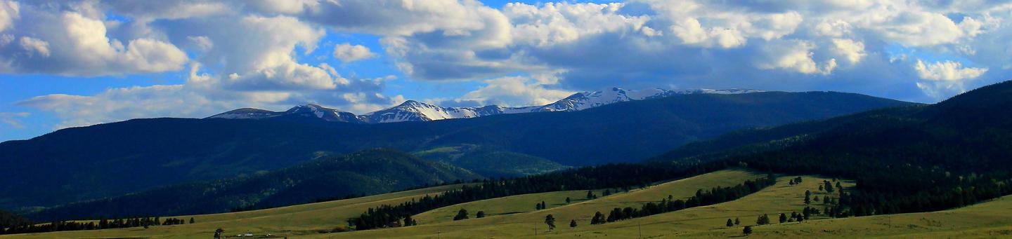
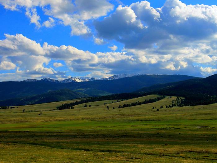
Pike and San Isabel National Forests & Cimarron and Comanche National Grasslands (forest locator map) cover nearly 3 million acres, between the prairies of western Kansas and some of Colorado's highest mountain peaks along the Continental Divide. These sprawling forests and grasslands are an eight hour drive from boundary to boundary. This landscape offers a variety of ecosystems rich in history, geology, scenery, wildlife habitat and recreation opportunities.
The rolling prairies to the east are home to prairie chickens, wildflowers, paleontological resources and historical areas. The snow-capped Rockies to the west are a scenic backdrop to millions of residents and a draw to forest visitors. The forests are home to nearly half of Colorado's fourteeners with numerous alpine lakes, reservoirs and key rivers. Over 385,000 acres of Wilderness, the Continental Divide National Scenic Trail, Colorado Trail, and Santa Fe National Historic Trail are special areas worth exploring.
People who live near these areas maintain a strong relationship to the lands. The commitment and volunteerism that these community members have for these public lands is the foundation for our ability to maintain a quality, sustainable recreation program in the face of intense, and growing, urban demand.
Critical Information about the use of Unmanned Aircraft Systems
Unmanned Aircraft Systems (UAS) or “drones” are increasing in popularity and can provide wonderful opportunities to explore the forest. Please be aware that these drones are regulated and must follow certain laws to be safe and legal.
- Recreational Drone Tips (.pdf)
- Forest Service Unmanned Aircraft Systems policy (fs.fed.us)
RecAreaDirections
Open with Google Map
Misc
| Stay Limit | |
| Reservable | false |
| Keywords | |
| Map Link | |
| Contact Phone | |
| Contact Email |
Permits info
Facilities
Ophir Creek Campground (CO) Campground
List of CampsitesOverview
This campground is usually open Memorial Day weekend through Labor Day weekend with full service and, depending on snow conditions, is usually open through the middle of October with reduced service.
Available activities include hiking, fishing, bicycling, motorcycle, and ATV. Fishing in Ophir Creek. A short drive will take you to various trailheads.
Recreation
Available activities include hiking, fishing, bicycling, motorcycle, and ATV. Fishing in Ophir Creek. A short drive will take you to various trailheads.
Facilities
Tent camping,Camping trailer,Toilets,Drinking water
Natural Features
Available activities include hiking, fishing, bicycling, motorcycle, and ATV. Fishing in Ophir Creek. A short drive will take you to various trailheads.
Nearby Attractions
Available activities include hiking, fishing, bicycling, motorcycle, and ATV. Fishing in Ophir Creek. A short drive will take you to various trailheads.
Charges & Cancellations
Cancellations
Individual Campsites: Cancellations up to 2 days before a reservation start date incur a $10.00 cancellation fee.
A visitor who cancels a reservation the day before or on the day of arrival will pay a $10.00 service fee AND forfeit the first night's use fee including tax and applicable add-on for a campsite.
Cancellations for a one-night reservation will forfeit the entire amount paid and will not be subject to an additional service fee.
No-Shows
A no-show visitor is one who does not arrive at a campground and does not cancel the reservation by check-out time on the day after the scheduled arrival date. Staff will hold a campsite until check-out time on the day following the arrival date.
No-shows are assessed $20.00 service fee and forfeit the first night's rate, taxes and applicable add-on for a campsite.
Refunds
Visitors may submit a refund request through their Recreation.gov profile within 7 days of the end date of their reservation. Refunds will not be issued after the 7 days has ended.
Refunds for debit or credit card payments will be issued as a credit to the original bank or credit card used to pay.
For check or cash purchases, Recreation.gov will mail a Treasury check for refunds of cash, check, or money order payments to the address associated with the reservation. Treasury check refunds may take up to 6-8 weeks to arrive.
In the event of an emergency closure, the Recreation.gov team or facility manager will refund all fees and will attempt to notify you using the contact information within the Recreation.gov visitor profile.
Rampart Range Recreation Area Designated Dispersed Camping Campground
List of CampsitesOverview
The Rampart Range Recreation Area's Designated Dispersed Camping is operated by Rocky Mountain Recreation Company. Camping is only allowed in numbered campsites and requires a fee. Trailhead parking within the Rampart Range Recreation Area is free. The Rampart Range Recreation Area is known for its motorized trail system (OHV's less than 50 inches in width), Devils Head Fire Lookout Tower, and climbing areas. Access to over 300 miles of motorized trails in this area, in addition to the motorized trails on the adjacent Pikes Peak Ranger District. Please use the Motor Vehicle Use Map (MVUM) for the South Platte Ranger District to determine your OHV route(s). All motorized vehicles must be registered with the State of Colorado and have a Forest Service approved spark arrestor.
Recreation
Rampart Range Recreation Area is known for its motorized trail system, Devils Head Fire Lookout Tower, and climbing areas. Access to over 300 miles of trails in this area, in addition to the motorized trails on the adjacent Pikes Peak Ranger District. Hiking trail to the meadow below the Devils Head Fire Lookout Tower.
Facilities
No water is available in this area. Please bring water from home. There are vault toilets at most trailheads and port-a-potties in the area. Trash is "Pack in - Pack out"...please take your trash home with you.
Natural Features
The Rampart Range Recreation Area is home to the Devils Head Lookout Tower. The tower is staffed by a U.S. Forest Service fire lookout personnel.
Nearby Attractions
Motorized trail system, Devils Head Fire Lookout Tower, and climbing areas.
Charges & Cancellations
Cancellations
Individual Campsites: Cancellations up to 2 days before a reservation start date incur a $10.00 cancellation fee.
A visitor who cancels a reservation the day before or on the day of arrival will pay a $10.00 service fee AND forfeit the first night's use fee including tax and applicable add-on for a campsite.
Cancellations for a one-night reservation will forfeit the entire amount paid and will not be subject to an additional service fee.
Group Sites
Group Facility (including Cabins and Lookouts): A visitor who cancels a group overnight facility reservation less than 14 days before the arrival date will pay a $10.00 service fee AND forfeit the first night's use fee.
No-Shows
A no-show visitor is one who does not arrive at a campground and does not cancel the reservation by check-out time on the day after the scheduled arrival date. Staff will hold a campsite until check-out time on the day following the arrival date.
No-shows are assessed $20.00 service fee and forfeit the first night's rate, taxes and applicable add-on for a campsite.
Refunds
Visitors may submit a refund request through their Recreation.gov profile within 7 days of the end date of their reservation. Refunds will not be issued after the 7 days has ended.
Refunds for debit or credit card payments will be issued as a credit to the original bank or credit card used to pay.
For check or cash purchases, Recreation.gov will mail a Treasury check for refunds of cash, check, or money order payments to the address associated with the reservation. Treasury check refunds may take up to 6-8 weeks to arrive.
In the event of an emergency closure, the Recreation.gov team or facility manager will refund all fees and will attempt to notify you using the contact information within the Recreation.gov visitor profile.
Angel of Shavano Campground
List of CampsitesOverview
This location is available on a first-come, first-served basis only. Visitors are required to physically arrive at the campground to purchase and claim a site. Once on-site, you may be able to pay for your campsite(s) by scanning a QR code using the Recreation.gov mobile app, and the Scan and Pay feature.
If this option is available, you will need to first download the free Recreation.gov mobile app https://www.recreation.gov/mobile-app prior to your arrival as some remote areas have limited or no cellular service.
Belle of Colorado Campground
List of CampsitesOverview
This location is available on a first-come, first-served basis only. Visitors are required to physically arrive at the campground to purchase and claim a site. Once on-site, you may be able to pay for your campsite(s) by scanning a QR code using the Recreation.gov mobile app, and the Scan and Pay feature.
If this option is available, you will need to first download the free Recreation.gov mobile app https://www.recreation.gov/mobile-app prior to your arrival as some remote areas have limited or no cellular service.
Bootleg Campground
List of CampsitesOverview
This location is available on a first-come, first-served basis only. Visitors are required to physically arrive at the campground to purchase and claim a site. Once on-site, you may be able to pay for your campsite(s) by scanning a QR code using the Recreation.gov mobile app, and the Scan and Pay feature.
If this option is available, you will need to first download the free Recreation.gov mobile app https://www.recreation.gov/mobile-app prior to your arrival as some remote areas have limited or no cellular service.
Cordova Pass Campground
List of CampsitesOverview
This location is available on a first-come, first-served basis only. Visitors are required to physically arrive at the campground to purchase and claim a site. Once on-site, you may be able to pay for your campsite(s) by scanning a QR code using the Recreation.gov mobile app, and the Scan and Pay feature.
If this option is available, you will need to first download the free Recreation.gov mobile app https://www.recreation.gov/mobile-app prior to your arrival as some remote areas have limited or no cellular service.
Cottonwood Lake - PSICC (Co) Campground
List of CampsitesOverview
This location is available on a first-come, first-served basis only. Visitors are required to physically arrive at the campground to purchase and claim a site. Once on-site, you may be able to pay for your campsite(s) by scanning a QR code using the Recreation.gov mobile app, and the Scan and Pay feature.
If this option is available, you will need to first download the free Recreation.gov mobile app https://www.recreation.gov/mobile-app prior to your arrival as some remote areas have limited or no cellular service.
Deer Creek Campground Campground
List of CampsitesOverview
This location is available on a first-come, first-served basis only. Visitors are required to physically arrive at the campground to purchase and claim a site. Once on-site, you may be able to pay for your campsite(s) by scanning a QR code using the Recreation.gov mobile app, and the Scan and Pay feature.
If this option is available, you will need to first download the free Recreation.gov mobile app https://www.recreation.gov/mobile-app prior to your arrival as some remote areas have limited or no cellular service.
Devils Head Campground Campground
List of CampsitesOverview
This location is available on a first-come, first-served basis only. Visitors are required to physically arrive at the campground to purchase and claim a site. Once on-site, you may be able to pay for your campsite(s) by scanning a QR code using the Recreation.gov mobile app, and the Scan and Pay feature.
If this option is available, you will need to first download the free Recreation.gov mobile app https://www.recreation.gov/mobile-app prior to your arrival as some remote areas have limited or no cellular service.
Dexter Campground
List of CampsitesOverview
This location is available on a first-come, first-served basis only. Visitors are required to physically arrive at the campground to purchase and claim a site. Once on-site, you may be able to pay for your campsite(s) by scanning a QR code using the Recreation.gov mobile app, and the Scan and Pay feature.
If this option is available, you will need to first download the free Recreation.gov mobile app https://www.recreation.gov/mobile-app prior to your arrival as some remote areas have limited or no cellular service.
Elbert Creek Campground
List of CampsitesOverview
This location is available on a first-come, first-served basis only. Visitors are required to physically arrive at the campground to purchase and claim a site. Once on-site, you may be able to pay for your campsite(s) by scanning a QR code using the Recreation.gov mobile app, and the Scan and Pay feature.
If this option is available, you will need to first download the free Recreation.gov mobile app https://www.recreation.gov/mobile-app prior to your arrival as some remote areas have limited or no cellular service.
Flat Rocks Campground Campground
List of CampsitesOverview
This location is available on a first-come, first-served basis only. Visitors are required to physically arrive at the campground to purchase and claim a site. Once on-site, you may be able to pay for your campsite(s) by scanning a QR code using the Recreation.gov mobile app, and the Scan and Pay feature.
If this option is available, you will need to first download the free Recreation.gov mobile app https://www.recreation.gov/mobile-app prior to your arrival as some remote areas have limited or no cellular service.
Fourmile Campground
List of CampsitesOverview
This location is available on a first-come, first-served basis only. Visitors are required to physically arrive at the campground to purchase and claim a site. Once on-site, you may be able to pay for your campsite(s) by scanning a QR code using the Recreation.gov mobile app, and the Scan and Pay feature.
If this option is available, you will need to first download the free Recreation.gov mobile app https://www.recreation.gov/mobile-app prior to your arrival as some remote areas have limited or no cellular service.
Goose Creek Campground Campground
List of CampsitesOverview
This location is available on a first-come, first-served basis only. Visitors are required to physically arrive at the campground to purchase and claim a site. Once on-site, you may be able to pay for your campsite(s) by scanning a QR code using the Recreation.gov mobile app, and the Scan and Pay feature.
If this option is available, you will need to first download the free Recreation.gov mobile app https://www.recreation.gov/mobile-app prior to your arrival as some remote areas have limited or no cellular service.
Green Montain Campground Campground
List of CampsitesOverview
This location is available on a first-come, first-served basis only. Visitors are required to physically arrive at the campground to purchase and claim a site. Once on-site, you may be able to pay for your campsite(s) by scanning a QR code using the Recreation.gov mobile app, and the Scan and Pay feature.
If this option is available, you will need to first download the free Recreation.gov mobile app https://www.recreation.gov/mobile-app prior to your arrival as some remote areas have limited or no cellular service.
Halfmoon East Campground
List of CampsitesOverview
This location is available on a first-come, first-served basis only. Visitors are required to physically arrive at the campground to purchase and claim a site. Once on-site, you may be able to pay for your campsite(s) by scanning a QR code using the Recreation.gov mobile app, and the Scan and Pay feature.
If this option is available, you will need to first download the free Recreation.gov mobile app https://www.recreation.gov/mobile-app prior to your arrival as some remote areas have limited or no cellular service.
Halfmoon West Campground
List of CampsitesOverview
This location is available on a first-come, first-served basis only. Visitors are required to physically arrive at the campground to purchase and claim a site. Once on-site, you may be able to pay for your campsite(s) by scanning a QR code using the Recreation.gov mobile app, and the Scan and Pay feature.
If this option is available, you will need to first download the free Recreation.gov mobile app https://www.recreation.gov/mobile-app prior to your arrival as some remote areas have limited or no cellular service.
Hall Valley Campground
List of CampsitesOverview
This location is available on a first-come, first-served basis only. Visitors are required to physically arrive at the campground to purchase and claim a site. Once on-site, you may be able to pay for your campsite(s) by scanning a QR code using the Recreation.gov mobile app, and the Scan and Pay feature.
If this option is available, you will need to first download the free Recreation.gov mobile app https://www.recreation.gov/mobile-app prior to your arrival as some remote areas have limited or no cellular service.
Handcart Campground
List of CampsitesOverview
This location is available on a first-come, first-served basis only. Visitors are required to physically arrive at the campground to purchase and claim a site. Once on-site, you may be able to pay for your campsite(s) by scanning a QR code using the Recreation.gov mobile app, and the Scan and Pay feature.
If this option is available, you will need to first download the free Recreation.gov mobile app https://www.recreation.gov/mobile-app prior to your arrival as some remote areas have limited or no cellular service.
Hayden Creek Campground
List of CampsitesOverview
This location is available on a first-come, first-served basis only. Visitors are required to physically arrive at the campground to purchase and claim a site. Once on-site, you may be able to pay for your campsite(s) by scanning a QR code using the Recreation.gov mobile app, and the Scan and Pay feature.
If this option is available, you will need to first download the free Recreation.gov mobile app https://www.recreation.gov/mobile-app prior to your arrival as some remote areas have limited or no cellular service.
Iron City Campground
List of CampsitesOverview
This location is available on a first-come, first-served basis only. Visitors are required to physically arrive at the campground to purchase and claim a site. Once on-site, you may be able to pay for your campsite(s) by scanning a QR code using the Recreation.gov mobile app, and the Scan and Pay feature.
If this option is available, you will need to first download the free Recreation.gov mobile app https://www.recreation.gov/mobile-app prior to your arrival as some remote areas have limited or no cellular service.
Lake Creek (Co) Campground
List of CampsitesOverview
This location is available on a first-come, first-served basis only. Visitors are required to physically arrive at the campground to purchase and claim a site. Once on-site, you may be able to pay for your campsite(s) by scanning a QR code using the Recreation.gov mobile app, and the Scan and Pay feature.
If this option is available, you will need to first download the free Recreation.gov mobile app https://www.recreation.gov/mobile-app prior to your arrival as some remote areas have limited or no cellular service.
Lost Park Campground
List of CampsitesOverview
This location is available on a first-come, first-served basis only. Visitors are required to physically arrive at the campground to purchase and claim a site. Once on-site, you may be able to pay for your campsite(s) by scanning a QR code using the Recreation.gov mobile app, and the Scan and Pay feature.
If this option is available, you will need to first download the free Recreation.gov mobile app https://www.recreation.gov/mobile-app prior to your arrival as some remote areas have limited or no cellular service.
Matchless Campground
List of CampsitesOverview
This location is available on a first-come, first-served basis only. Visitors are required to physically arrive at the campground to purchase and claim a site. Once on-site, you may be able to pay for your campsite(s) by scanning a QR code using the Recreation.gov mobile app, and the Scan and Pay feature.
If this option is available, you will need to first download the free Recreation.gov mobile app https://www.recreation.gov/mobile-app prior to your arrival as some remote areas have limited or no cellular service.
Meridian Campground Campground
List of CampsitesOverview
This location is available on a first-come, first-served basis only. Visitors are required to physically arrive at the campground to purchase and claim a site. Once on-site, you may be able to pay for your campsite(s) by scanning a QR code using the Recreation.gov mobile app, and the Scan and Pay feature.
If this option is available, you will need to first download the free Recreation.gov mobile app https://www.recreation.gov/mobile-app prior to your arrival as some remote areas have limited or no cellular service.
Michigan Creek Campground
List of CampsitesOverview
This location is available on a first-come, first-served basis only. Visitors are required to physically arrive at the campground to purchase and claim a site. Once on-site, you may be able to pay for your campsite(s) by scanning a QR code using the Recreation.gov mobile app, and the Scan and Pay feature.
If this option is available, you will need to first download the free Recreation.gov mobile app https://www.recreation.gov/mobile-app prior to your arrival as some remote areas have limited or no cellular service.
North Fork Campground (Salida, CO) Campground
List of CampsitesOverview
This location is available on a first-come, first-served basis only. Visitors are required to physically arrive at the campground to purchase and claim a site. Once on-site, you may be able to pay for your campsite(s) by scanning a QR code using the Recreation.gov mobile app, and the Scan and Pay feature.
If this option is available, you will need to first download the free Recreation.gov mobile app https://www.recreation.gov/mobile-app prior to your arrival as some remote areas have limited or no cellular service.
Osprey (CO) Campground
List of CampsitesOverview
This location is available on a first-come, first-served basis only. Visitors are required to physically arrive at the campground to purchase and claim a site. Once on-site, you may be able to pay for your campsite(s) by scanning a QR code using the Recreation.gov mobile app, and the Scan and Pay feature.
If this option is available, you will need to first download the free Recreation.gov mobile app https://www.recreation.gov/mobile-app prior to your arrival as some remote areas have limited or no cellular service.
Ouzel Campground
List of CampsitesOverview
This location is available on a first-come, first-served basis only. Visitors are required to physically arrive at the campground to purchase and claim a site. Once on-site, you may be able to pay for your campsite(s) by scanning a QR code using the Recreation.gov mobile app, and the Scan and Pay feature.
If this option is available, you will need to first download the free Recreation.gov mobile app https://www.recreation.gov/mobile-app prior to your arrival as some remote areas have limited or no cellular service.
Parry Peak Campground
List of CampsitesOverview
This location is available on a first-come, first-served basis only. Visitors are required to physically arrive at the campground to purchase and claim a site. Once on-site, you may be able to pay for your campsite(s) by scanning a QR code using the Recreation.gov mobile app, and the Scan and Pay feature.
If this option is available, you will need to first download the free Recreation.gov mobile app https://www.recreation.gov/mobile-app prior to your arrival as some remote areas have limited or no cellular service.
Platte River Campground
List of CampsitesOverview
This location is available on a first-come, first-served basis only. Visitors are required to physically arrive at the campground to purchase and claim a site. Once on-site, you may be able to pay for your campsite(s) by scanning a QR code using the Recreation.gov mobile app, and the Scan and Pay feature.
If this option is available, you will need to first download the free Recreation.gov mobile app https://www.recreation.gov/mobile-app prior to your arrival as some remote areas have limited or no cellular service.
Selkirk Campground
List of CampsitesOverview
This location is available on a first-come, first-served basis only. Visitors are required to physically arrive at the campground to purchase and claim a site. Once on-site, you may be able to pay for your campsite(s) by scanning a QR code using the Recreation.gov mobile app, and the Scan and Pay feature.
If this option is available, you will need to first download the free Recreation.gov mobile app https://www.recreation.gov/mobile-app prior to your arrival as some remote areas have limited or no cellular service.
Springdale Campground
List of CampsitesOverview
This location is available on a first-come, first-served basis only. Visitors are required to physically arrive at the campground to purchase and claim a site. Once on-site, you may be able to pay for your campsite(s) by scanning a QR code using the Recreation.gov mobile app, and the Scan and Pay feature.
If this option is available, you will need to first download the free Recreation.gov mobile app https://www.recreation.gov/mobile-app prior to your arrival as some remote areas have limited or no cellular service.
Tabor Campground
List of CampsitesOverview
This location is available on a first-come, first-served basis only. Visitors are required to physically arrive at the campground to purchase and claim a site. Once on-site, you may be able to pay for your campsite(s) by scanning a QR code using the Recreation.gov mobile app, and the Scan and Pay feature.
If this option is available, you will need to first download the free Recreation.gov mobile app https://www.recreation.gov/mobile-app prior to your arrival as some remote areas have limited or no cellular service.
The Crags Campground
List of CampsitesOverview
This location is available on a first-come, first-served basis only. Visitors are required to physically arrive at the campground to purchase and claim a site. Once on-site, you may be able to pay for your campsite(s) by scanning a QR code using the Recreation.gov mobile app, and the Scan and Pay feature.
If this option is available, you will need to first download the free Recreation.gov mobile app https://www.recreation.gov/mobile-app prior to your arrival as some remote areas have limited or no cellular service.
Twin Eagle Campground
List of CampsitesOverview
This location is available on a first-come, first-served basis only. Visitors are required to physically arrive at the campground to purchase and claim a site. Once on-site, you may be able to pay for your campsite(s) by scanning a QR code using the Recreation.gov mobile app, and the Scan and Pay feature.
If this option is available, you will need to first download the free Recreation.gov mobile app https://www.recreation.gov/mobile-app prior to your arrival as some remote areas have limited or no cellular service.
Twin Peaks (CO) Campground
List of CampsitesOverview
This location is available on a first-come, first-served basis only. Visitors are required to physically arrive at the campground to purchase and claim a site. Once on-site, you may be able to pay for your campsite(s) by scanning a QR code using the Recreation.gov mobile app, and the Scan and Pay feature.
If this option is available, you will need to first download the free Recreation.gov mobile app https://www.recreation.gov/mobile-app prior to your arrival as some remote areas have limited or no cellular service.
Weston Pass Campground
List of CampsitesOverview
This location is available on a first-come, first-served basis only. Visitors are required to physically arrive at the campground to purchase and claim a site. Once on-site, you may be able to pay for your campsite(s) by scanning a QR code using the Recreation.gov mobile app, and the Scan and Pay feature.
If this option is available, you will need to first download the free Recreation.gov mobile app https://www.recreation.gov/mobile-app prior to your arrival as some remote areas have limited or no cellular service.
Pulver Mountain Group Site Campground
List of CampsitesOverview
Pulver group site offers a private area with large pavilion with several tables and a large communal campfire pit. For your convenience, a double-stall vaulted restroom is provided. Within the group site are 6 individual campsites for your guest, each having their own table and campfire ring. Firewood is provided by roaming host who can be located nearby at Round Mountain campground. Access to the west field is by foot only and for your use of additional tents, recreation, or main even activities.
Recreation
- Being in the National Forest, nearby is Eleven Mile Canyon. The canyon is part of the historical Midland Railroad. You can drive along the railbed, following the the South Platte River for nine miles to the base of the dam of Eleven Mile Reservoir, while enjoying the beautiful scenery of the river and granite canyon. The open area of Eleven Mile Reservoir is state park whereas the canyon (National Forest) is reknown for the picturesque views, rock climbing, kayaking, and fishing.
- Jefferson Lake is about 45 minutes north with spectacular wildlife, hiking, and hand launched boating. The depth of the lake is unknown and flows towards the basin of Pulver Group Site, into Tarryall Reservoir. The state park of Tarryall reservoir is visiting often for fishing by boat and shoreline.
- Offroading is located just outside the gate to Pulver group site to the south. To the north, Badger Flats area offers a large area to explore and admire the beauty of sub-alpine terrain. This area shows remnents of early settlers and active ranching. (OHV must be trailered to/from).
Facilities
1 pavilion, 1 large group-campfire ring, Double-stall vaulted restroom, 6 moveable tables in pavilion, 6 stationary tables at individual campsites, 6 campfire rings, Private activity field, Firewood available via roaming hosts and management.
Natural Features
This fairly flat terrain is covered with natural grasses and speckled with pines providing plenty of shade. If solar and sunbathing is in your itinerary, a generous amount of sun is easily acquired as well.
contact_info
For facility specific information, please call (719) 396-4192.Nearby Attractions
NATIONAL FOREST AREAS: - Eleven Mile Canyon - Badger Flats - Wilkerson Pass - Manitou Lakes - Rampart Range - Deckers - Pikes Peak - Norht Catamount Reservoir - Clear Creek Reservoir -
NATIONAL MONUMENT: - Florissant Fossil Beds
STATE PARK AREAS: - Eleven Mile reservoir - Spinney Mountain Reservoir - Mueller State Park - Taryall Reservoir - Antero Reservoir,
NEARBY TOWNS: - Lake George - Woodland Park - Cripple Creek - Fairplay
ANGEL OF SHAVANO GROUP Campground
List of CampsitesOverview
Angel of Shavano Group Campground is considered one of the area's best kept camping secrets. It is situated next to the North Fork South Arkansas River and offers a variety of recreational activities, including hiking, biking and fishing. Reservations are REQUIRED at this facility.Recreation
The Colorado Trail begins within the campground and provides excellent hiking, horseback riding and biking opportunities. The trail stretches 487 miles across Colorado from Denver to Durango, with segments ranging in elevation from 5,500 to 13,300 feet. The North Fork South Arkansas River flows next to the campground and it offers rainbow and brook trout fishing. Fun facilities like a volleyball court, baseball field and horseshoe pits are available within the campground. Visitors must bring their own equipment.Facilities
Angel of Shavano offers one group campsite best suited for tent camping. It can accommodate up to 100 people and 12-14 vehicles. Parking is not available for large RVs. The site is equipped with a picnic shelter, tables, six pedestal grills and a campfire circle with benches. Vault toilets and trash collection are provided. No drinking water is available within the group site, but it is available at the nearby family campground.Natural Features
The campground is named after an image of an angel that appears as winter snow fall on Shavano Mountain. The site lies at an elevation of 9,200 feet along the North Fork South Arkansas River. A forest of aspen and pine covers the area. Beaver ponds dot the landscape at the base of nearby Shavano Mountain.Nearby Attractions
From the Angel of Shavano Group Campground the road continues west for 6 miles to the North Fork reservoir and campground. The road is extremely rocky and rough and high clearance vehicles are recommend. The reservoir is regularly stocked with rainbow trout and it offers anglers a chance to fish one of the area's most popular high elevation lakes. It is situated at 11,000 feet so anglers should be prepared for all types of weather. The Monarch Crest Scenic Tramway is located on the top of Monarch Pass at 11,312 feet (3.45 km), which is on the Continental Divide at the southern end of the Sawatch Mountain Range. The Monarch Crest is along the border between Gunnison and Chaffee counties, approximately 25 miles (40 km) west of the town of Salida.Charges & Cancellations
Group Sites
Group Facility (including Cabins and Lookouts): A visitor who cancels a group overnight facility reservation less than 14 days before the arrival date will pay a $10.00 service fee AND forfeit the first night's use fee.
No-Shows
A no-show visitor is one who does not arrive at a campground and does not cancel the reservation by check-out time on the day after the scheduled arrival date. Staff will hold a campsite until check-out time on the day following the arrival date.
No-shows are assessed $20.00 service fee and forfeit the first night's rate, taxes and applicable add-on for a campsite.
Refunds
Visitors may submit a refund request through their Recreation.gov profile within 7 days of the end date of their reservation. Refunds will not be issued after the 7 days has ended.
Refunds for debit or credit card payments will be issued as a credit to the original bank or credit card used to pay.
For check or cash purchases, Recreation.gov will mail a Treasury check for refunds of cash, check, or money order payments to the address associated with the reservation. Treasury check refunds may take up to 6-8 weeks to arrive.
In the event of an emergency closure, the Recreation.gov team or facility manager will refund all fees and will attempt to notify you using the contact information within the Recreation.gov visitor profile.
CASCADE (COLORADO) Campground
List of CampsitesOverview
Cascade Campground is located in beautiful Chaffee County, Colorado. This popular facility sits near Cascade Falls and is within 5 miles of a private hot springs resort, making it an ideal location for rest and relaxation.
"First come, first served" does not necessarily mean that the site will be available when you get there. Someone may get there before you. This is a popular campground and is normally full starting on Friday, sometimes as early as Thursday, so plan accordingly.
Recreation
Stream fishing is best above Cascade Falls, just accross the road from the campground. Nearby Chalk Lake is heralded as a great family fishing lake with rainbow, brook and brown trout. Plenty of off-road vehicle trails are a short distance away. Recommended rides include Mount Antero, Baldwin Lake, Tincup Pass, Hancock Pass, Pomeroy Lakes, Hancock Lakes. Hiking in the area includes the Colorado Trail, The Narrow Gauge trail and the Cascade Loop Trail (Across from Chalk Lake Campground)Facilities
The campground offers 21 single-family sites, each equipped with a picnic table and campfire ring. Vault toilets and drinking water are provided. Firewood is sold on-site. Sites #2- 7 and 11, 12 are "walk-up" first-come, first served. All other sites are reservable. Site #1 is used by the host from mid-May to Labor Day weekend. After that time it is available as a "walk-up", first-come, first-served site.Natural Features
The campground is situated in a dense forest of Douglas fir and aspen at an elevation of 9,000 feet in Chalk Creek Canyon, which gets its name from the soft, white, chalk-like kaolinite canyon walls. Kaolinite is a clay mineral that was deposited by percolating hot springs.Chalk Creek is just across the road from the campground. It flows 27 miles eastward from the Collegiate Peaks before joining the Arkansas River. Chalk Lake is a mile east of the campground.
Nearby Attractions
Take a day trip to the historic ghost town of St. Elmo, just 15 minutes from the campground. An old saloon, county courthouse and many other historic structures remain from the days of its mining glory. The city of Salida and Town of Buena Vista are only a short drive away where visitors can enjoy distinctive restaurants, unique shops, incredible art galleries and a large selection of antique shops. The area boasts more than 100 miles of Arkansas River to raft, fish, float or kayak in. as well as fifteen 14,000 ft mountains. Visitors choose from recreational activities like hiking, biking, ATVing, kayaking, rafting, fishing, horseback riding, zipping, swimmingCharges & Cancellations
Cancellations
Individual Campsites: Cancellations up to 2 days before a reservation start date incur a $10.00 cancellation fee.
A visitor who cancels a reservation the day before or on the day of arrival will pay a $10.00 service fee AND forfeit the first night's use fee including tax and applicable add-on for a campsite.
Cancellations for a one-night reservation will forfeit the entire amount paid and will not be subject to an additional service fee.
No-Shows
A no-show visitor is one who does not arrive at a campground and does not cancel the reservation by check-out time on the day after the scheduled arrival date. Staff will hold a campsite until check-out time on the day following the arrival date.
No-shows are assessed $20.00 service fee and forfeit the first night's rate, taxes and applicable add-on for a campsite.
Refunds
Visitors may submit a refund request through their Recreation.gov profile within 7 days of the end date of their reservation. Refunds will not be issued after the 7 days has ended.
Refunds for debit or credit card payments will be issued as a credit to the original bank or credit card used to pay.
For check or cash purchases, Recreation.gov will mail a Treasury check for refunds of cash, check, or money order payments to the address associated with the reservation. Treasury check refunds may take up to 6-8 weeks to arrive.
In the event of an emergency closure, the Recreation.gov team or facility manager will refund all fees and will attempt to notify you using the contact information within the Recreation.gov visitor profile.
CHALK LAKE Campground
List of CampsitesOverview
Chalk Lake Campground is located in beautiful Chaffee County, Colorado. This popular facility sits near Chalk Lake and is within 4 miles of a private hot springs resort, making it an ideal location for rest and relaxation.
"First come, first served" does not necessarily mean that the site will be available when you get there. Someone may get there before you. This is a popular campground and is normally full starting on Friday, sometimes as early as Thursday, so plan accordingly.
Recreation
Chalk Lake is located next to the campground and is a great family fishing spot with rainbow, brook and brown trout. Motorized boats are not allowed on the lake. Chalk Creek also offers fishing, and it's best above Cascade Falls. Plenty of off-road vehicle trails are near the campground. Recommended rides include Mount Antero, Baldwin Lake, Tincup Pass, Hancock Pass, Pomeroy Lakes, and Hancock Lakes. The Cascade Loop Trail is located across the street from the campground. The Chalk Creek Trailhead is about 2 miles east of the campground which gives hikers access to the extensive Colorado Trail, which extends nearly 500 miles from Denver to Durango.Facilities
The campground offers single-family sites, a few of which are accessible. Each site is equipped with a picnic table and campfire ring. Accessible vault toilets are provided. Firewood is sold on-site. Sites: #4-9, and 14 "walk-up", first-come, first-served sites. All other sites are reservable. Site #1 is used by the host from mid-May to mid-September. After that time it is available as a "walk-up", first-come, first-served site.Natural Features
The campground sits at an elevation of 9,000 feet in Chalk Creek Canyon, which gets its name from the soft, white, chalk-like kaolinite canyon walls. Kaolinite is a clay mineral that was deposited by percolating hot springs. A variety of wildlife makes its home in the area, including chipmunks, hummingbirds, birds of prey and mule deer.Nearby Attractions
Take a day trip to the historic ghost town of St. Elmo, just 15 minutes from the campground. An old saloon, county courthouse and many other historic structures remain from the days of its mining glory. Rock hounds come to the area in search of quartz and aquamarine. The city of Salida and Town of Buena Vista are only a short drive away where visitors can enjoy distinctive restaurants, unique shops, incredible art galleries and a large selection of antique shops. The area boasts more than 100 miles of Arkansas River to raft, fish, float or kayak in, as well as fifteen 14,000 ft mountains. Visitors can choose from recreational activities like hiking, biking, ATV/UTV riding, kayaking, rafting, fishing, horseback riding, zipping and swimming.Charges & Cancellations
Cancellations
Individual Campsites: Cancellations up to 2 days before a reservation start date incur a $10.00 cancellation fee.
A visitor who cancels a reservation the day before or on the day of arrival will pay a $10.00 service fee AND forfeit the first night's use fee including tax and applicable add-on for a campsite.
Cancellations for a one-night reservation will forfeit the entire amount paid and will not be subject to an additional service fee.
No-Shows
A no-show visitor is one who does not arrive at a campground and does not cancel the reservation by check-out time on the day after the scheduled arrival date. Staff will hold a campsite until check-out time on the day following the arrival date.
No-shows are assessed $20.00 service fee and forfeit the first night's rate, taxes and applicable add-on for a campsite.
Refunds
Visitors may submit a refund request through their Recreation.gov profile within 7 days of the end date of their reservation. Refunds will not be issued after the 7 days has ended.
Refunds for debit or credit card payments will be issued as a credit to the original bank or credit card used to pay.
For check or cash purchases, Recreation.gov will mail a Treasury check for refunds of cash, check, or money order payments to the address associated with the reservation. Treasury check refunds may take up to 6-8 weeks to arrive.
In the event of an emergency closure, the Recreation.gov team or facility manager will refund all fees and will attempt to notify you using the contact information within the Recreation.gov visitor profile.
COLLEGIATE PEAKS Campground
List of CampsitesOverview
Collegiate Peaks Campground is located 11 miles west of Buena Vista, Colorado, along Middle Cottonwood Creek near the top of Cottonwood Pass. The campground offers well-spaced campsites and scenic views of the surrounding mountains. Visitors enjoy fishing and exploring local trails. A commercial hot springs inn and spa is located about 5 miles east of the campground.
"First come, first served" does not necessarily mean that the site will be available when you get there. Someone may get there before you. This is a popular campground and is normally full starting on Friday, sometimes as early as Thursday, so plan accordingly.
Recreation
Hiking and fishing are among the most popular activities. The Denny Creek Trailhead is less than a mile away and it take hikers through Collegiate Peaks Wilderness Area to destinations such as Kroenke Lake and Mt. Yale. The Ptarmigan Lake Trailhead is less than 3 miles from the campground and boasts views of vivid wildflowers. Middle Cottonwood Creek is small but fairly well-stocked with brook trout. Determined anglers can often pull rainbow and cutthroat trout from the beaver ponds west of the campground.Facilities
The campground offers several single-family sites on three loops. Each site is equipped with a picnic table, campfire ring and grill. Vault toilets and drinking water are provided. Sites# 1, and 18-30 are first come-first served, also called "Walk-up" sites. All other sites are reservable. Site #2 is used by the host from mid-May through September. After that time it is available as a "walk-up", first-come, first-served site.Natural Features
The campground sits at an elevation of 9,800 feet, tucked in a dense stand of mixed conifers and aspen. Some sites sit alongside the creek while others are tucked back in the woods. Afternoon thunderstorms are common during summer months.Nearby Attractions
Cottonwood Pass is a high mountain pass across the Continental Divide in the Sawatch Range of the Rocky Mountains. The road reaches the divide at an elevation of 12,126 feet. The Collegiate Peaks Wilderness offers challenging trails and prime backcountry fishing lakes. The Town of Buena Vista is only a short drive away where visitors can enjoy distinctive restaurants, unique shops, incredible art galleries and a large selection of antique shops. The area boasts more than 100 miles of Arkansas River to raft, fish, float or kayak in, as well as fifteen 14,000 ft mountains. Visitors can choose from recreational activities like hiking, biking, ATV/UTV riding, kayaking, rafting, fishing, horseback riding, zipping and swimming.Charges & Cancellations
Cancellations
Individual Campsites: Cancellations up to 2 days before a reservation start date incur a $10.00 cancellation fee.
A visitor who cancels a reservation the day before or on the day of arrival will pay a $10.00 service fee AND forfeit the first night's use fee including tax and applicable add-on for a campsite.
Cancellations for a one-night reservation will forfeit the entire amount paid and will not be subject to an additional service fee.
No-Shows
A no-show visitor is one who does not arrive at a campground and does not cancel the reservation by check-out time on the day after the scheduled arrival date. Staff will hold a campsite until check-out time on the day following the arrival date.
No-shows are assessed $20.00 service fee and forfeit the first night's rate, taxes and applicable add-on for a campsite.
Refunds
Visitors may submit a refund request through their Recreation.gov profile within 7 days of the end date of their reservation. Refunds will not be issued after the 7 days has ended.
Refunds for debit or credit card payments will be issued as a credit to the original bank or credit card used to pay.
For check or cash purchases, Recreation.gov will mail a Treasury check for refunds of cash, check, or money order payments to the address associated with the reservation. Treasury check refunds may take up to 6-8 weeks to arrive.
In the event of an emergency closure, the Recreation.gov team or facility manager will refund all fees and will attempt to notify you using the contact information within the Recreation.gov visitor profile.
MOUNT PRINCETON Campground
List of CampsitesOverview
Mount Princeton Campground is located in beautiful Chalk Creek Canyon in central Colorado. This popular facility is within 4 miles of a private hot springs resort, making it an ideal location for rest and relaxation.
"First come, first served" does not necessarily mean that the site will be available when you get there. Someone may get there before you. This is a popular campground and is normally full starting on Friday, sometimes as early as Thursday, so plan accordingly.
Recreation
Stream fishing is best above Cascade Falls, about 2 miles west of the campground. Nearby Chalk Lake is heralded as a great family fishing lake with rainbow, brook and brown trout.
Nearby ATV/UTV and 4X4 rides include Mount Antero, Baldwin Lake, Tincup Pass, Hancock Pass, Pomeroy Lakes, Hancock Lakes.
Facilities
The campground offers single-family sites, a few of which are wheelchair accessible. Each site is equipped with a picnic table and campfire ring with grill. Wheelchair accessible vault toilets are provided. Firewood is sold on-site. Parking spurs are gravel.
Sites #1, and 14-17 are "walk-up", first-come, first-served sites. All other sites are reservable.
Site #2 is used by the host from mid-May to Labor Day weekend, after that it is available as a "walk-up", first-come, first-served site.
Natural Features
The campground is situated at an elevation of 8,600 feet in Chalk Creek Canyon, which gets its name from the soft, white, chalk-like kaolinite canyon walls. Kaolinite is a clay mineral that was deposited by percolating hot springs. A stand of ponderosa pine and Douglas fir offers partial shade in the campground. Chalk Creek can be accessed from the campground. It flows 27 miles eastward from the Collegiate Peaks before joining the Arkansas River. Chalk Lake is about a mile west of the campground.Nearby Attractions
Take a day trip to the historic ghost town of St. Elmo, just 15 minutes from the campground. An old saloon, county courthouse and many other historic structures remain from the days of its mining glory. Rock hounds come to the area in search of quartz and aquamarine.
The city of Salida and Town of Buena Vista are only a short drive away where visitors can enjoy unique restaurants, shops, and art galleries. The area boasts more than 100 miles of Arkansas River to raft, fish, float or kayak, as well as fifteen 14,000 ft. mountains. Visitors can choose from recreational activities like hiking, biking, ATV/UTV riding, kayaking, rafting, fishing, horseback riding, ziplining and swimming.
Charges & Cancellations
Cancellations
Individual Campsites: Cancellations up to 2 days before a reservation start date incur a $10.00 cancellation fee.
A visitor who cancels a reservation the day before or on the day of arrival will pay a $10.00 service fee AND forfeit the first night's use fee including tax and applicable add-on for a campsite.
Cancellations for a one-night reservation will forfeit the entire amount paid and will not be subject to an additional service fee.
No-Shows
A no-show visitor is one who does not arrive at a campground and does not cancel the reservation by check-out time on the day after the scheduled arrival date. Staff will hold a campsite until check-out time on the day following the arrival date.
No-shows are assessed $20.00 service fee and forfeit the first night's rate, taxes and applicable add-on for a campsite.
Refunds
Visitors may submit a refund request through their Recreation.gov profile within 7 days of the end date of their reservation. Refunds will not be issued after the 7 days has ended.
Refunds for debit or credit card payments will be issued as a credit to the original bank or credit card used to pay.
For check or cash purchases, Recreation.gov will mail a Treasury check for refunds of cash, check, or money order payments to the address associated with the reservation. Treasury check refunds may take up to 6-8 weeks to arrive.
In the event of an emergency closure, the Recreation.gov team or facility manager will refund all fees and will attempt to notify you using the contact information within the Recreation.gov visitor profile.
OHAVER LAKE Campground
List of CampsitesOverview
O'Haver Lake Campground sits at an elevation of 9,200 feet, with ponderosa pines and aspen. It is located on the shores of O'Haver Lake. This facility has 31 sites and is a very popular destination that is often full on the weekends.
"First come, first served" does not necessarily mean that the site will be available when you get there. Someone may get there before you. This is a popular campground and is normally full starting on Friday, sometimes as early as Thursday, so plan accordingly.
Recreation
There is an accessible fishing pier and non-motorized watercraft can be used to seek rainbow and brook trout on O'Haver Lake. If using non-motorized watercraft please be courteous to those who are fishing.Facilities
Vault toilets, drinking water and trash collection and campground host are provided. Firewood is sold on site. Sites #1-5, 7 ,13,21,23 and 24 are first-come, first-served, "Walk-up" sites. All other sites are reservable. Site #6 is used by the host from mid-May through September. After that time it is available as a "walk-up", first-come, first-served site.Natural Features
This area attracts many campers for fishing, bird watching and canoeing on the calm, pleasant lake. Ponderosa pines provide a fresh vanilla scent in the mountain air and aspens please visitors with golden foliage displays in autumn.Nearby Attractions
The historic Denver and Rio Grande railroad grade traveled from Salida, southwest to the summit of Marshall Pass. The grade travels along County Road 200 above O'Haver Lake. This is a very popular mountain biking route with cyclists traveling from Monarch Pass to Marshall Pass on the Crest trail and then traveling down the railroad grade into Poncha Springs. Silver Creek, Starvation Creek, Poncha Creek and the Rainbow Trail are also nearby trails. Shirley Site is located off of Highway 285 and County Road 200 just below Poncha Pass. Shirley got its name during the 1880's when it served as a busy construction camp for men building the Denver and Rio Grande rail line over Marshall Pass to the ore-rich mines in Gunnison. By summer of 1881, Shirley boasted 14 large business tents, most of which were saloons and dance halls. Little remains of the town of Shirley except the coal stained railbed that can be seen just north of the Shirley site parking area. Shirley Site is a popular staging area for OHV riders and mountain bikers during the summer months and snowmobilers during winter.Charges & Cancellations
Cancellations
Individual Campsites: Cancellations up to 2 days before a reservation start date incur a $10.00 cancellation fee.
A visitor who cancels a reservation the day before or on the day of arrival will pay a $10.00 service fee AND forfeit the first night's use fee including tax and applicable add-on for a campsite.
Cancellations for a one-night reservation will forfeit the entire amount paid and will not be subject to an additional service fee.
No-Shows
A no-show visitor is one who does not arrive at a campground and does not cancel the reservation by check-out time on the day after the scheduled arrival date. Staff will hold a campsite until check-out time on the day following the arrival date.
No-shows are assessed $20.00 service fee and forfeit the first night's rate, taxes and applicable add-on for a campsite.
Refunds
Visitors may submit a refund request through their Recreation.gov profile within 7 days of the end date of their reservation. Refunds will not be issued after the 7 days has ended.
Refunds for debit or credit card payments will be issued as a credit to the original bank or credit card used to pay.
For check or cash purchases, Recreation.gov will mail a Treasury check for refunds of cash, check, or money order payments to the address associated with the reservation. Treasury check refunds may take up to 6-8 weeks to arrive.
In the event of an emergency closure, the Recreation.gov team or facility manager will refund all fees and will attempt to notify you using the contact information within the Recreation.gov visitor profile.
MEADOW RIDGE Campground
List of CampsitesOverview
Located about 10 miles from the town of Woodland Park, Colorado, Meadow Ridge Campground is pleasantly situated on a ridge above the Rampart Reservoir. Here, campers have access to prime fishing and mountain biking and hiking trails. The campground is in the Front Range of the Rocky Mountains, due north of the popular Pikes Peak. The peak has an altitude of 14,110 feet and was first climbed in 1820. Its claim to fame is that it is America's easternmost peak over 14,000 feet.Recreation
Rainbow and mackinaw trout are plentiful in the renowned fishing reservoir and hikers enjoy the trails in the area. Rampart Reservoir Trail and Nichols Reservoir Trail are both worth exploring. Rampart Reservoir Trail extends for 14 miles and is open to mountain biking.Facilities
Most campsites are nicely shaded with a grassy understory, and have limited privacy from other sites. Drinking water, picnic tables, campfire rings and two accessible vault toilets are provided for campers. At sites 6,7,10,14,16 and 18, the picnic table and campfire ring are below the road, and steps must be used to reach them. Firewood can be purchased onsite.Natural Features
Sitting in a ponderosa pine forest at 9,200 feet, the 19-site campground overlooks the Rampart Reservoir. The surrounding terrain includes a mix of grass meadows, spruce, Douglas fir and aspen.Nearby Attractions
Take the kids on a tour of the U.S. Air Force Academy or explore the quaint town of Green Mountain Falls. While there, ask the locals about the place they nicknamed Kermit the Frog Mountain.Charges & Cancellations
Cancellations
Individual Campsites: Cancellations up to 2 days before a reservation start date incur a $10.00 cancellation fee.
A visitor who cancels a reservation the day before or on the day of arrival will pay a $10.00 service fee AND forfeit the first night's use fee including tax and applicable add-on for a campsite.
Cancellations for a one-night reservation will forfeit the entire amount paid and will not be subject to an additional service fee.
No-Shows
A no-show visitor is one who does not arrive at a campground and does not cancel the reservation by check-out time on the day after the scheduled arrival date. Staff will hold a campsite until check-out time on the day following the arrival date.
No-shows are assessed $20.00 service fee and forfeit the first night's rate, taxes and applicable add-on for a campsite.
Refunds
Visitors may submit a refund request through their Recreation.gov profile within 7 days of the end date of their reservation. Refunds will not be issued after the 7 days has ended.
Refunds for debit or credit card payments will be issued as a credit to the original bank or credit card used to pay.
For check or cash purchases, Recreation.gov will mail a Treasury check for refunds of cash, check, or money order payments to the address associated with the reservation. Treasury check refunds may take up to 6-8 weeks to arrive.
In the event of an emergency closure, the Recreation.gov team or facility manager will refund all fees and will attempt to notify you using the contact information within the Recreation.gov visitor profile.
PIKE COMMUNITY Campground
List of CampsitesOverview
Pike Community is a group campground located about 6 miles north of Woodland Park in central Colorado. It is a popular choice for of all ages, complete with a baseball field, playground, sand volleyball court and a horseshoe pit. Campers enjoy nearby access to hiking and biking trails.Recreation
Plenty of on-site fun presents itself with activities like baseball, horseshoes and volleyball. Campers must bring their own sports equipment. The nearby Centennial Trail is a paved, accessible recreation trail that connects Pike Community Group Campground to Manitou Lake Picnic Area as well as Colorado and South Meadows Campgrounds. The trail is popular among hikers, roller bladers and bicyclists. Rainbow Falls OHV Trail System and North Divide OHV Trail System are recommended for off-road vehicle enthusiasts. Manitou Lake offers trout fishing and canoeing on the small, 5-acre lake.Facilities
Pike Community offers one large group site that can accommodate up to 100 people and 48 vehicles. The site is equipped with picnic and serving tables, grills and a campfire circle. Vault toilets, drinking water and trash collection are provided. A host is located across the road at South Meadows Campground.Natural Features
The campground is nestled in a ponderosa pine forest at an elevation of 7,700 feet.Nearby Attractions
The town of Woodland Park is located approximately 6 miles south of Pike Community Group Campground, where campers can find gas, groceries, dining and shopping. Colorado Springs is about 25 miles southeast of the campground and offers many services. Garden of the Gods is a popular attraction just outside of town. This free park offers hiking trails, rock climbing routes, a visitor center and cafe. Pikes Peak lies west of Manitou Springs, which is about 20 miles from the campground. Visitors can hike, or drive to the summit of this beautiful mountain.Charges & Cancellations
Group Sites
Group Facility (including Cabins and Lookouts): A visitor who cancels a group overnight facility reservation less than 14 days before the arrival date will pay a $10.00 service fee AND forfeit the first night's use fee.
No-Shows
A no-show visitor is one who does not arrive at a campground and does not cancel the reservation by check-out time on the day after the scheduled arrival date. Staff will hold a campsite until check-out time on the day following the arrival date.
No-shows are assessed $20.00 service fee and forfeit the first night's rate, taxes and applicable add-on for a campsite.
Refunds
Visitors may submit a refund request through their Recreation.gov profile within 7 days of the end date of their reservation. Refunds will not be issued after the 7 days has ended.
Refunds for debit or credit card payments will be issued as a credit to the original bank or credit card used to pay.
For check or cash purchases, Recreation.gov will mail a Treasury check for refunds of cash, check, or money order payments to the address associated with the reservation. Treasury check refunds may take up to 6-8 weeks to arrive.
In the event of an emergency closure, the Recreation.gov team or facility manager will refund all fees and will attempt to notify you using the contact information within the Recreation.gov visitor profile.
RED ROCKS GROUP CAMPGROUND Campground
List of CampsitesOverview
Red Rocks Group Campground is located 4 miles north of the town of Woodland Park, Colorado. Visitors enjoy the area for hiking, biking and visiting the nearby 5-acre Manitou Lake.Recreation
The Centennial Bike Trail is a paved, accessible recreation trail that connects Red Rocks Group Campground to Manitou Lake Picnic Area, Colorado and South Meadows Campgrounds. The trail is popular among hikers, roller bladers and bicyclists. The nearby Rainbow Falls OHV Trail System and North Divide OHV Trail System are recommended for off-road vehicle enthusiasts. Manitou Lake is a short drive away, and is great for picnics and trout fishing. Canoeing is also a popular activity.Facilities
The campground offers one group site that can accommodate up to 100 people and 44 vehicles. It can be reserved for overnight or day use. The site is equipped with picnic tables and a campfire circle with benches. Additional tables and grills are scattered throughout the area. Vault toilets, drinking water and trash collection are provided.Natural Features
This rustic group site is situated in a ponderosa pine forest at an elevation of 8,200 feet. A nearby hiking trail leads to a unique red sandstone formation. Most of Red Rocks Group Campground is shaded by ponderosa pine trees.Nearby Attractions
The town of Woodland Park is located 4 miles south of the campground, where campers can find gas, groceries, dining and shopping. Colorado Springs is about 20 miles southeast of the campground and offers many services. Garden of the Gods is a popular attraction just outside of town. This free park offers hiking trails, rock climbing routes, a visitor center and cafe. Pikes Peak lies west of Manitou Springs, which is about 15 miles from the campground. Visitors can hike, bike, or drive to the summit of this beautiful mountain.Charges & Cancellations
Group Sites
Group Facility (including Cabins and Lookouts): A visitor who cancels a group overnight facility reservation less than 14 days before the arrival date will pay a $10.00 service fee AND forfeit the first night's use fee.
No-Shows
A no-show visitor is one who does not arrive at a campground and does not cancel the reservation by check-out time on the day after the scheduled arrival date. Staff will hold a campsite until check-out time on the day following the arrival date.
No-shows are assessed $20.00 service fee and forfeit the first night's rate, taxes and applicable add-on for a campsite.
Refunds
Visitors may submit a refund request through their Recreation.gov profile within 7 days of the end date of their reservation. Refunds will not be issued after the 7 days has ended.
Refunds for debit or credit card payments will be issued as a credit to the original bank or credit card used to pay.
For check or cash purchases, Recreation.gov will mail a Treasury check for refunds of cash, check, or money order payments to the address associated with the reservation. Treasury check refunds may take up to 6-8 weeks to arrive.
In the event of an emergency closure, the Recreation.gov team or facility manager will refund all fees and will attempt to notify you using the contact information within the Recreation.gov visitor profile.
THUNDER RIDGE Campground
List of CampsitesOverview
Thunder Ridge Campground, located above the Rampart Reservoir, is one of two campgrounds within the Rampart Reservoir Recreation Area. The campground overlooks the reservoir, which is popular for fishing. Boating and hiking are also common activities for campers here.The campground is located on the Front Range of the Rocky Mountains, due north of the popular Pikes Peak. The peak has an altitude of 14,110 feet and is America's easternmost peak reaching over 14,000 feet.
Recreation
Rainbow and mackinaw trout are plentiful in the reservoir and hikers can enjoy the trails in the area. Rampart Reservoir Trail is nearby. Rampart Reservoir Trail extends for 14 miles and is open to hiking and mountain biking.Facilities
Three campsites and two of the vault toilets meet current accessibility standards. Most remaining sites have steps that lead below the road level to the site picnic table and campfire ring. Drinking water is provided and each site comes with a picnic table and campfire ring. Firewood can be purchased on-site.Natural Features
The campground overlooks the Rampart Reservoir in a ponderosa pine forest at an altitude of 9,200 feet. The surrounding terrain includes a mix of grass meadows, spruce, Douglas fir and aspen.Nearby Attractions
The U.S. Air Force Academy in Colorado Springs offers tours, and a visit to the quaint town of Green Mountain Falls makes a great day trip.Charges & Cancellations
Cancellations
Individual Campsites: Cancellations up to 2 days before a reservation start date incur a $10.00 cancellation fee.
A visitor who cancels a reservation the day before or on the day of arrival will pay a $10.00 service fee AND forfeit the first night's use fee including tax and applicable add-on for a campsite.
Cancellations for a one-night reservation will forfeit the entire amount paid and will not be subject to an additional service fee.
No-Shows
A no-show visitor is one who does not arrive at a campground and does not cancel the reservation by check-out time on the day after the scheduled arrival date. Staff will hold a campsite until check-out time on the day following the arrival date.
No-shows are assessed $20.00 service fee and forfeit the first night's rate, taxes and applicable add-on for a campsite.
Refunds
Visitors may submit a refund request through their Recreation.gov profile within 7 days of the end date of their reservation. Refunds will not be issued after the 7 days has ended.
Refunds for debit or credit card payments will be issued as a credit to the original bank or credit card used to pay.
For check or cash purchases, Recreation.gov will mail a Treasury check for refunds of cash, check, or money order payments to the address associated with the reservation. Treasury check refunds may take up to 6-8 weeks to arrive.
In the event of an emergency closure, the Recreation.gov team or facility manager will refund all fees and will attempt to notify you using the contact information within the Recreation.gov visitor profile.
BUFFALO CAMPGROUND Campground
List of CampsitesOverview
Buffalo Campground is one of two facilities within the Buffalo Creek Recreation Area, about an hour's drive southwest of Denver, Colorado. Visitors enjoy a variety of recreational opportunities, including hiking, mountain biking and trout fishing.
Recreation
The Buffalo Creek Recreation Area is home to a 40-mile trail system most popular with mountain bikers, but hikers and horseback riders enjoy the area as well. Several trailheads are within walking distance of the campground. The Lost Creek Wilderness Area can be accessed via the Colorado Trail, which stretches nearly 500 miles from Denver to Durango.Buffalo Creek is a popular fishing stream for brook trout.
Facilities
The campground offers single-family sites, some of which are designated for tent camping only. Each site is equipped with accessible picnic tables and campfire rings with grills. Vault toilets are provided. No hookups are available.Natural Features
The campground is situated near Buffalo Creek at an elevation of 7,400 feet in the Front Range of the Rocky Mountains. Summer temperatures are mild and range from 75-80 degrees during the day to 55-65 degrees at night.Nearby Attractions
The drive along County Road 126 southwest from Pine Junction affords magnificent views of the valleys below. Pikes Peak, at 14,110 feet, can be seen in the distance and other prominent rock formations present themselves throughout the scenic drive.Charges & Cancellations
Cancellations
Individual Campsites: Cancellations up to 2 days before a reservation start date incur a $10.00 cancellation fee.
A visitor who cancels a reservation the day before or on the day of arrival will pay a $10.00 service fee AND forfeit the first night's use fee including tax and applicable add-on for a campsite.
Cancellations for a one-night reservation will forfeit the entire amount paid and will not be subject to an additional service fee.
No-Shows
A no-show visitor is one who does not arrive at a campground and does not cancel the reservation by check-out time on the day after the scheduled arrival date. Staff will hold a campsite until check-out time on the day following the arrival date.
No-shows are assessed $20.00 service fee and forfeit the first night's rate, taxes and applicable add-on for a campsite.
Refunds
Visitors may submit a refund request through their Recreation.gov profile within 7 days of the end date of their reservation. Refunds will not be issued after the 7 days has ended.
Refunds for debit or credit card payments will be issued as a credit to the original bank or credit card used to pay.
For check or cash purchases, Recreation.gov will mail a Treasury check for refunds of cash, check, or money order payments to the address associated with the reservation. Treasury check refunds may take up to 6-8 weeks to arrive.
In the event of an emergency closure, the Recreation.gov team or facility manager will refund all fees and will attempt to notify you using the contact information within the Recreation.gov visitor profile.
KELSEY CAMPGROUND Campground
List of CampsitesOverview
Kelsey is one of two campgrounds within the Buffalo Creek Recreation Area, about an hour's drive southwest of Denver, Colorado. Visitors enjoy a variety of recreational opportunities, including hiking, rock climbing, mountain biking and trout fishing.Recreation
The Buffalo Creek Recreation Area is home to a 40-mile trail system most popular with mountain bikers, but hikers and horseback riders enjoy the area as well. Several trailheads are within the area, including Little Scraggy Trail, just 3 miles north of the campground. Access to the Colorado Trail and the Buffalo Burn Trail begin from this trailhead. Shinglemill Trail is also nearby.Buffalo Creek is a popular fishing stream for brook trout. The area offers great wildlife viewing opportunities for turkey, elk, mule deer, chipmunks and porcupines.
Facilities
The campground offers single-family sites, some of which are designated for tent camping only. Each site is equipped with picnic tables and campfire rings with grills. Vault toilets are provided. Drinking water is available from a hand pump, but hookups are not available.Natural Features
The campground sits at an elevation of 7,400 feet in the Front Range of the Rocky Mountains. Summer temperatures are mild and range from 75-80 during the day to 55-65 at night.The Kelsey Overlook is just north of the campground along County Road 126, offering beautiful views of the valley below.
Nearby Attractions
The drive along County Road 126 southwest from Pine Junction affords magnificent views of the valleys below. Pikes Peak, at 14,110 feet, can be seen in the distance and other prominent rock formations present themselves throughout the scenic drive.Charges & Cancellations
Cancellations
Individual Campsites: Cancellations up to 2 days before a reservation start date incur a $10.00 cancellation fee.
A visitor who cancels a reservation the day before or on the day of arrival will pay a $10.00 service fee AND forfeit the first night's use fee including tax and applicable add-on for a campsite.
Cancellations for a one-night reservation will forfeit the entire amount paid and will not be subject to an additional service fee.
No-Shows
A no-show visitor is one who does not arrive at a campground and does not cancel the reservation by check-out time on the day after the scheduled arrival date. Staff will hold a campsite until check-out time on the day following the arrival date.
No-shows are assessed $20.00 service fee and forfeit the first night's rate, taxes and applicable add-on for a campsite.
Refunds
Visitors may submit a refund request through their Recreation.gov profile within 7 days of the end date of their reservation. Refunds will not be issued after the 7 days has ended.
Refunds for debit or credit card payments will be issued as a credit to the original bank or credit card used to pay.
For check or cash purchases, Recreation.gov will mail a Treasury check for refunds of cash, check, or money order payments to the address associated with the reservation. Treasury check refunds may take up to 6-8 weeks to arrive.
In the event of an emergency closure, the Recreation.gov team or facility manager will refund all fees and will attempt to notify you using the contact information within the Recreation.gov visitor profile.
LONE ROCK CAMPGROUND (CO) Campground
List of CampsitesOverview
Lone Rock Campground, located along the South Platte River, boasts spectacular views and top-notch fly fishing waters. Hikers thoroughly enjoy the nearby Gill Trail and kayakers are drawn to the rapids of the rushing river. Wildlife viewing is rewarding here and campers may spot moose, mule deer, owls, golden eagles and more.Recreation
Anglers flock to the river, renowned for rainbow and brown trout fishing. Tubing is also a popular activity.The Gill Trail is an intermediate hike that weaves through Cheesman Canyon. The trailhead is near the campground and extends 7 miles southwest to the Cheesman Dam at Cheesman Lake.
Facilities
Amenities include two vault toilets and drinking water from a community hydrant. Parking aprons and roads are paved, and each campsite has a picnic table and campfire ring. No RV hookups are available. Services include trash collection and firewood is available for sale.Natural Features
The campground is situated on a hillside rising up from the South Platte River at an elevation of 6,479 feet. Many sites are open and feature a view of the river. Privacy is minimal but ponderosa pines provide some shade. Temperatures are generally mild.Nearby Attractions
The drive along Highway 126 from Pine Junction affords magnificent views of the valleys below. Pikes Peak can be seen in the distance and other prominent rock formations present themselves throughout the scenic drive.Limited groceries are available in the town of Decker.
Charges & Cancellations
Cancellations
Individual Campsites: Cancellations up to 2 days before a reservation start date incur a $10.00 cancellation fee.
A visitor who cancels a reservation the day before or on the day of arrival will pay a $10.00 service fee AND forfeit the first night's use fee including tax and applicable add-on for a campsite.
Cancellations for a one-night reservation will forfeit the entire amount paid and will not be subject to an additional service fee.
No-Shows
A no-show visitor is one who does not arrive at a campground and does not cancel the reservation by check-out time on the day after the scheduled arrival date. Staff will hold a campsite until check-out time on the day following the arrival date.
No-shows are assessed $20.00 service fee and forfeit the first night's rate, taxes and applicable add-on for a campsite.
Refunds
Visitors may submit a refund request through their Recreation.gov profile within 7 days of the end date of their reservation. Refunds will not be issued after the 7 days has ended.
Refunds for debit or credit card payments will be issued as a credit to the original bank or credit card used to pay.
For check or cash purchases, Recreation.gov will mail a Treasury check for refunds of cash, check, or money order payments to the address associated with the reservation. Treasury check refunds may take up to 6-8 weeks to arrive.
In the event of an emergency closure, the Recreation.gov team or facility manager will refund all fees and will attempt to notify you using the contact information within the Recreation.gov visitor profile.
MEADOWS GROUP CAMPGROUND Campground
List of CampsitesOverview
Meadows Group Campground offers a wonderful opportunity for groups to enjoy the great outdoors. Located just 45 miles south of Denver near the town of Buffalo Creek, Colorado, the campground provides easy access to trout fishing, hiking and mountain biking.Recreation
Several trailheads for mountain biking, hiking and horseback riding are within a half mile radius of the campground. The Buffalo Creek mountain bike area and the Lost Creek Wilderness Area can be accessed from the campground via the Colorado Trail.Buffalo Creek is a popular fishing area for brook trout.
Facilities
Two group campsites are available and each one fits up to 150 campers. Accessible picnic tables and vault toilets are onsite. Firewood is available at Buffalo Campground, a half-mile east on Forest Road 550. Please bring your own water.
Natural Features
The campground sits at an elevation of 7,400 feet in the Front Range of the Rocky Mountains. Temperatures are generally mild. About 67 miles south is Pikes Peak at an altitude of 14,110 feet. It is heralded as the easternmost mountain peak over 14,000 feet in the United States.Nearby Attractions
Head to Wellington Lake or hike up one of the many peaks like Little Scraggy Peak.Charges & Cancellations
Group Sites
Group Facility (including Cabins and Lookouts): A visitor who cancels a group overnight facility reservation less than 14 days before the arrival date will pay a $10.00 service fee AND forfeit the first night's use fee.
No-Shows
A no-show visitor is one who does not arrive at a campground and does not cancel the reservation by check-out time on the day after the scheduled arrival date. Staff will hold a campsite until check-out time on the day following the arrival date.
No-shows are assessed $20.00 service fee and forfeit the first night's rate, taxes and applicable add-on for a campsite.
Refunds
Visitors may submit a refund request through their Recreation.gov profile within 7 days of the end date of their reservation. Refunds will not be issued after the 7 days has ended.
Refunds for debit or credit card payments will be issued as a credit to the original bank or credit card used to pay.
For check or cash purchases, Recreation.gov will mail a Treasury check for refunds of cash, check, or money order payments to the address associated with the reservation. Treasury check refunds may take up to 6-8 weeks to arrive.
In the event of an emergency closure, the Recreation.gov team or facility manager will refund all fees and will attempt to notify you using the contact information within the Recreation.gov visitor profile.
BABY DOE Campground
List of CampsitesOverview
Baby Doe Campground is situated on the eastern shore of Turquoise Lake in the shade of a lodgepole pine and subalpine fir forest. This family-friendly campground is a popular summer destination for boating, hiking and fishing.
The campground was named for Elizabeth McCourt, whose nickname was Baby Doe. She made a name for herself in the Colorado mining community in the 19th century when she took on the rugged work of a miner.
Recreation
The 1.2-mile Turquoise Lake Nature Trail meanders along the shoreline is a gentle loop trail through the forest and down to the shoreline of Turquoise Lake. This trail connects to the 6.4-mile Turquoise Lake Trail that parallels the shoreline from Sugar Loaf Dam to May Queen Campground. Trail guides are available at the trailhead located about a mile south, at the entrance to Molly Brown Campground.On the lake, boating, sailing, canoeing and fishing are favorite activities. Anglers fish for stocked cutthroat, rainbow, brown and lake trout. A boat ramp is located about a mile south of the campground.
Facilities
The campground offers single-family sites, some of which are accessible. Each site is equipped with a picnic table and campfire ring. Vault toilets, drinking water and trash collection are provided. Firewood is available for purchase from the Host. Parking spurs are gravel or dirt.
Natural Features
Campsites are perched along the scenic lakeshore. The Mount Massive Wilderness Area, a 30,540 acre stretch of primitive land boasting Colorado's second highest peak at 14,421 feet, is nearby. Much of the wilderness is above timberline with many alpine plant communities and permanent snowfields.Nearby Attractions
Venture to Independence Pass for a scenic drive with breathtaking views of the Rockies and surrounding alpine tundra habitat. At 12,095 feet, it is one of the highest paved mountain passes in the country and marks where the Top of the Rockies National Scenic and Historic Byway crosses the Continental Divide.Charges & Cancellations
Cancellations
Individual Campsites: Cancellations up to 2 days before a reservation start date incur a $10.00 cancellation fee.
A visitor who cancels a reservation the day before or on the day of arrival will pay a $10.00 service fee AND forfeit the first night's use fee including tax and applicable add-on for a campsite.
Cancellations for a one-night reservation will forfeit the entire amount paid and will not be subject to an additional service fee.
No-Shows
A no-show visitor is one who does not arrive at a campground and does not cancel the reservation by check-out time on the day after the scheduled arrival date. Staff will hold a campsite until check-out time on the day following the arrival date.
No-shows are assessed $20.00 service fee and forfeit the first night's rate, taxes and applicable add-on for a campsite.
Refunds
Visitors may submit a refund request through their Recreation.gov profile within 7 days of the end date of their reservation. Refunds will not be issued after the 7 days has ended.
Refunds for debit or credit card payments will be issued as a credit to the original bank or credit card used to pay.
For check or cash purchases, Recreation.gov will mail a Treasury check for refunds of cash, check, or money order payments to the address associated with the reservation. Treasury check refunds may take up to 6-8 weeks to arrive.
In the event of an emergency closure, the Recreation.gov team or facility manager will refund all fees and will attempt to notify you using the contact information within the Recreation.gov visitor profile.
FATHER DYER Campground
List of CampsitesOverview
Father Dyer Campground is situated on the eastern shore of Turquoise Lake in the shade of a lodgepole pine and subalpine fir forest. The family-friendly campground is a popular summer destination for boating, hiking and fishing.The campground is named after Father John Lewis Dyer, one of the first Methodist ministers to tour Colorado's high country mining camps. For 20 years, beginning in 1862, he travelled the circuit encompassing Alma, Fairplay and Leadville, regularly skiing over the 13,186-foot Mosquito Pass on long, wooden skis.
Recreation
The 1.2-mile Turquoise Lake Nature Trail is a gentle loop trail through the forest and down to the shoreline of Turquoise Lake. This trail connects to the 6.4-mile Turquoise Lake Trail that parallels the shoreline from Sugar Loaf Dam to May Queen Campground. Trail guides are available at the trailhead located about a mile south, at the entrance to Molly Brown Campground. On the lake, boating, sailing, canoeing and fishing are favorite activities. Anglers fish for stocked cutthroat, rainbow, brown and lake trout. Matchless Boat Ramp is located about two miles south of the campground.Facilities
The campground offers single-family sites. Each site is equipped with a picnic table and campfire ring. Vault toilets, drinking water and trash collection are provided. Firewood is available for purchase from the Host. Parking spurs are gravel or dirt.
Natural Features
Campsites are nestled in the forest near the scenic lakeshore. The Mount Massive Wilderness Area, a 30,540 acre stretch of primitive land encompassing Colorado's second highest peak at 14,421 feet, is nearby. Much of the wilderness is above timberline with many alpine plant communities and permanent snowfields.Nearby Attractions
Venture to Independence Pass for a scenic drive with breathtaking views of the Rockies and surrounding alpine tundra habitat. At 12,095 feet, it is one of the highest paved mountain passes in the country and marks where the Top of the Rockies National Scenic and Historic Byway crosses the Continental Divide.Charges & Cancellations
Cancellations
Individual Campsites: Cancellations up to 2 days before a reservation start date incur a $10.00 cancellation fee.
A visitor who cancels a reservation the day before or on the day of arrival will pay a $10.00 service fee AND forfeit the first night's use fee including tax and applicable add-on for a campsite.
Cancellations for a one-night reservation will forfeit the entire amount paid and will not be subject to an additional service fee.
No-Shows
A no-show visitor is one who does not arrive at a campground and does not cancel the reservation by check-out time on the day after the scheduled arrival date. Staff will hold a campsite until check-out time on the day following the arrival date.
No-shows are assessed $20.00 service fee and forfeit the first night's rate, taxes and applicable add-on for a campsite.
Refunds
Visitors may submit a refund request through their Recreation.gov profile within 7 days of the end date of their reservation. Refunds will not be issued after the 7 days has ended.
Refunds for debit or credit card payments will be issued as a credit to the original bank or credit card used to pay.
For check or cash purchases, Recreation.gov will mail a Treasury check for refunds of cash, check, or money order payments to the address associated with the reservation. Treasury check refunds may take up to 6-8 weeks to arrive.
In the event of an emergency closure, the Recreation.gov team or facility manager will refund all fees and will attempt to notify you using the contact information within the Recreation.gov visitor profile.
LA VISTA CAMPGROUND - LAKE ISABEL Campground
List of CampsitesOverview
La Vista Campground is situated in a meadow overlooking the west side of the 40-acre Lake Isabel. It is set along the Frontier Pathways and Historic Byway in the Wet Mountains along one of the Colorado Birding Trails.Lake Isabel is one of the few lakes in Colorado developed purely for recreation purposes. Built by the Civilian Conservation Corps, the lake attracts many campers who come to hike, canoe, fish and spend time bird watching. St. Charles Creek flows near the campground and offers additional fishing opportunities.
Recreation
Lake Isabel welcomes non-motorized boating and fishing. Brown and brook trout are stocked in the lake and the St. Charles headwaters reap brook trout.Visitors can enjoy hiking, bicycling or motorcycling on either the Snow Slide Trail and Cisneros Trail. The 15-mile Cisneros Trail, also open to ATV riders, leads to the heart of the Wet Mountains, through forests and open, wildflower speckled valleys. Along the way, the trail connects to St. Charles Trail, which heads to St. Charles Peak.
Facilities
Walk-in tent sites are 15 to 50 yards from the parking spurs. RV sites come with electric hookups and all sites include a picnic table, campfire ring and access to vault toilets and drinking water.Natural Features
Shady pine and aspen trees are scattered throughout the campground. At 8,600 feet, the area enjoys cool summer days, a welcome relief from the heat in the plains far below.The Pike and San Isabel National Forest includes over a million acres of wilderness and over half of Colorado's mountain peaks that reach above 14,000 feet.
Nearby Attractions
A nearby lodge provides paddle and rowboat rentals, groceries and a restaurant. Golf courses are about 15 minutes away.Charges & Cancellations
Cancellations
Individual Campsites: Cancellations up to 2 days before a reservation start date incur a $10.00 cancellation fee.
A visitor who cancels a reservation the day before or on the day of arrival will pay a $10.00 service fee AND forfeit the first night's use fee including tax and applicable add-on for a campsite.
Cancellations for a one-night reservation will forfeit the entire amount paid and will not be subject to an additional service fee.
No-Shows
A no-show visitor is one who does not arrive at a campground and does not cancel the reservation by check-out time on the day after the scheduled arrival date. Staff will hold a campsite until check-out time on the day following the arrival date.
No-shows are assessed $20.00 service fee and forfeit the first night's rate, taxes and applicable add-on for a campsite.
Refunds
Visitors may submit a refund request through their Recreation.gov profile within 7 days of the end date of their reservation. Refunds will not be issued after the 7 days has ended.
Refunds for debit or credit card payments will be issued as a credit to the original bank or credit card used to pay.
For check or cash purchases, Recreation.gov will mail a Treasury check for refunds of cash, check, or money order payments to the address associated with the reservation. Treasury check refunds may take up to 6-8 weeks to arrive.
In the event of an emergency closure, the Recreation.gov team or facility manager will refund all fees and will attempt to notify you using the contact information within the Recreation.gov visitor profile.
LAKEVIEW CAMPGROUND Campground
List of CampsitesOverview
Lakeview Campground, with wonderful views of the Twin Lakes Reservoir, is located about 20 miles south of Leadville, Colorado. The campground attracts many hikers looking to explore nature and the hiking trails in the surrounding area. Boaters can launch their craft at the nearby boat dock and fishing enthusiasts can find numerous locations at Twin Lakes Reservoir for fishing.
Recreation
The Continental Divide Trail, which runs from Canada to Mexico, is a non-motorized trail that passes Lakeview Campground. Mountain bikes are allowed in the section from Halfmoon Road south to Twin Lakes. Approximately 300 miles of the trail goes through Colorado.South of the campground lies Twin Lakes, Colorado's largest natural glacier lakes. Sailing and water skiing are among the popular activities here. Fishing includes lake, rainbow and mackinaw trout.
Facilities
This campground has single family sites. Each site is equipped with a picnic table and campfire ring. Vault toilets, drinking water, and trash collection are provided. Firewood may be purchased at the Host site.
Natural Features
Lakeview is situated in a ponderosa pine and sage habitat at an elevation of 9,500 feet. The site is between Mt. Elbert Forebay and Twin Lakes. The Twin Lakes Reservoir spans 2,805 acres and Mount Elbert stands tall at 14,433 feet. To the north is the Mount Massive Wilderness area, 30,540 acres encompassing Mount Massive, Colorado’s second highest peak at 14,421 feet. To the south is the Collegiate Peaks Wilderness with 8 peaks over 14,000 ft high. Much of the wilderness is above timberline with many alpine plant communities and permanent snowfields.Nearby Attractions
The Top of the Rockies Scenic Byway leads to Independence Pass, one of the highest paved passes in Colorado. The historic mining town, Leadville, is a half hour away.Charges & Cancellations
Cancellations
Individual Campsites: Cancellations up to 2 days before a reservation start date incur a $10.00 cancellation fee.
A visitor who cancels a reservation the day before or on the day of arrival will pay a $10.00 service fee AND forfeit the first night's use fee including tax and applicable add-on for a campsite.
Cancellations for a one-night reservation will forfeit the entire amount paid and will not be subject to an additional service fee.
No-Shows
A no-show visitor is one who does not arrive at a campground and does not cancel the reservation by check-out time on the day after the scheduled arrival date. Staff will hold a campsite until check-out time on the day following the arrival date.
No-shows are assessed $20.00 service fee and forfeit the first night's rate, taxes and applicable add-on for a campsite.
Refunds
Visitors may submit a refund request through their Recreation.gov profile within 7 days of the end date of their reservation. Refunds will not be issued after the 7 days has ended.
Refunds for debit or credit card payments will be issued as a credit to the original bank or credit card used to pay.
For check or cash purchases, Recreation.gov will mail a Treasury check for refunds of cash, check, or money order payments to the address associated with the reservation. Treasury check refunds may take up to 6-8 weeks to arrive.
In the event of an emergency closure, the Recreation.gov team or facility manager will refund all fees and will attempt to notify you using the contact information within the Recreation.gov visitor profile.
MOLLY BROWN Campground
List of CampsitesOverview
Named after the "unsinkable" Molly Brown on the Titanic, Molly Brown Campground, on the eastern shore of Turquoise Lake, sits in a shaded lodgepole pine forest. The campground offers access to boating, fishing, and hiking.
The famous Molly Brown lived in the town of Leadville, just 5 miles east of the campground. She became wealthy from her husband's mining success and took on a life as a philanthropist, socialite and activist.
Recreation
The 1.2-mile Turquoise Lake Nature Trail is a gentle loop trail through the forest and down to the shoreline of Turquoise Lake. This trail connects to the 6.4 mile Turquoise Lake Trail that parallels the shoreline from the dam to May Queen Campground. It is recommended that hikers pick up a trail guide prior to departure to learn about the flora and fauna along this trail. On the lake, sailing, boating and canoeing are always enjoyed. Anglers seek out mostly mackinaw and rainbow trout.Facilities
The two-loop campground offers single family sites. Each site is equipped with a picnic table and campfire ring. Vault toilets, drinking water, and trash collection are provided. Firewood is for sale at the Host site.
Natural Features
Campsites are perched along the scenic waters of the lake. Nearby is the Mount Massive Wilderness area, a 30,540 acre stretch of forest land which encompasses Colorado's second highest peak, Mount Massive at 14,421 feet. Much of the wilderness is above timberline with many alpine plant communities and permanent snowfields.Nearby Attractions
The town of Leadville, a historic gold and silver mining town, is a fun place to explore with the family.Drive on the Top of the Rockies Scenic Byway to Independence Pass, one of the highest paved passes in Colorado. Continue over the pass to the town of Aspen, a well-known ski resort town.
Charges & Cancellations
Cancellations
Individual Campsites: Cancellations up to 2 days before a reservation start date incur a $10.00 cancellation fee.
A visitor who cancels a reservation the day before or on the day of arrival will pay a $10.00 service fee AND forfeit the first night's use fee including tax and applicable add-on for a campsite.
Cancellations for a one-night reservation will forfeit the entire amount paid and will not be subject to an additional service fee.
No-Shows
A no-show visitor is one who does not arrive at a campground and does not cancel the reservation by check-out time on the day after the scheduled arrival date. Staff will hold a campsite until check-out time on the day following the arrival date.
No-shows are assessed $20.00 service fee and forfeit the first night's rate, taxes and applicable add-on for a campsite.
Refunds
Visitors may submit a refund request through their Recreation.gov profile within 7 days of the end date of their reservation. Refunds will not be issued after the 7 days has ended.
Refunds for debit or credit card payments will be issued as a credit to the original bank or credit card used to pay.
For check or cash purchases, Recreation.gov will mail a Treasury check for refunds of cash, check, or money order payments to the address associated with the reservation. Treasury check refunds may take up to 6-8 weeks to arrive.
In the event of an emergency closure, the Recreation.gov team or facility manager will refund all fees and will attempt to notify you using the contact information within the Recreation.gov visitor profile.
PRINTER BOY Campground
List of CampsitesOverview
Printer Boy Group Campground is located near Turquoise Lake, in an area with plenty of recreational opportunities, including boating, fishing and hiking.Recreation
Hikers enjoy the 1.2-mile Turquoise Lake Nature Trail. The gentle path meanders through the forest and down to the shoreline of Turquoise Lake where it connects with the 6.4-mile Turquoise Lake Trail. Trail guides are available at the Turquoise Lake Trail trailhead, located at the entrance to Molly Brown Campground.On the lake, boating, sailing, canoeing and fishing are favorite activities. Anglers fish for stocked cutthroat, rainbow, brown and lake trout. A boat ramp is located nearby.
The campground offers a playground, ball fields, horseshoe pits and a volleyball court. Campers must bring their own sports equipment.
Facilities
Printer Boy offers four group sites: 1 and 4 can accommodate up to 75 people; 2 and 3 can accommodate up to 35 people. Sites 3 and 4 are accessible.Each site is equipped with picnic tables, a campfire circle and grill. A centrally-located cooking shelter is available on a first-come, first-served basis. Vault toilets, drinking water and trash collection are provided. A dump station is located just outside the campground.
Natural Features
The campground is situated within walking distance of the lakeshore in a forest of lodgepole pine and subalpine fir.The Mount Massive Wilderness area, a 30,540 acre stretch of primitive land is nearby. Much of the wilderness is above timberline with many alpine plant communities and permanent snowfields.
Nearby Attractions
The nearby town of Leadville, a historic gold and silver mining town, is worth visiting for its small town charm.Venture to Independence Pass for a scenic drive with breathtaking views of the Rockies and surrounding alpine tundra habitat. At 12,095 feet, it is one of the highest paved mountain passes in the country and marks where the Top of the Rockies National Scenic and Historic Byway crosses the Continental Divide.
Charges & Cancellations
Group Sites
Group Facility (including Cabins and Lookouts): A visitor who cancels a group overnight facility reservation less than 14 days before the arrival date will pay a $10.00 service fee AND forfeit the first night's use fee.
No-Shows
A no-show visitor is one who does not arrive at a campground and does not cancel the reservation by check-out time on the day after the scheduled arrival date. Staff will hold a campsite until check-out time on the day following the arrival date.
No-shows are assessed $20.00 service fee and forfeit the first night's rate, taxes and applicable add-on for a campsite.
Refunds
Visitors may submit a refund request through their Recreation.gov profile within 7 days of the end date of their reservation. Refunds will not be issued after the 7 days has ended.
Refunds for debit or credit card payments will be issued as a credit to the original bank or credit card used to pay.
For check or cash purchases, Recreation.gov will mail a Treasury check for refunds of cash, check, or money order payments to the address associated with the reservation. Treasury check refunds may take up to 6-8 weeks to arrive.
In the event of an emergency closure, the Recreation.gov team or facility manager will refund all fees and will attempt to notify you using the contact information within the Recreation.gov visitor profile.
ST CHARLES CAMPGROUND - LAKE ISABEL Campground
List of CampsitesOverview
Nestled among aspen and tall Douglas fir trees, St. Charles Campground is in a quiet part of the Lake Isabel Recreation Area. Located on the banks of St. Charles Creek, the campground is popular with campers who enjoy the sounds of water tumbling through the shaded boulders.Recreation
Lake Isabel is stocked with brown and rainbow trout. The accessible lakeshore path provides ample fishing spots. Brook trout can be found in St. Charles Creek. Several trails begin at the recreation area. Hiking opportunities include the Snowslide Trail and the Cisneros Trail. Both trails are also open to motorcycles, and Cisneros is a challenging ATV route.Facilities
Campsites can accommodate small trailers; tent pads are provided for tent campers. Each campsite contains a bear-proof food locker, picnic table, fire ring and fire pedestal. Campground amenities include accessible vault toilets, drinking water from a hand pump, and bear-proof trash dumpsters. Firewood is sold by the on-site campground host.Natural Features
The campground sits a mile west of Lake Isabel in the Wet Mountains, a beautiful range in the San Isabel National Forest. At an elevation of 8,600 feet, Lake Isabel was designed and constructed in the 1930s as a recreational haven from the dusty plains far below. Rugged mountain peaks in the area provide water for the abundant wildlife and fish populations.Nearby Attractions
A nearby lodge offers paddle and rowboat rentals, groceries and a restaurant. Golf courses are about 15 minutes away.Charges & Cancellations
Cancellations
Individual Campsites: Cancellations up to 2 days before a reservation start date incur a $10.00 cancellation fee.
A visitor who cancels a reservation the day before or on the day of arrival will pay a $10.00 service fee AND forfeit the first night's use fee including tax and applicable add-on for a campsite.
Cancellations for a one-night reservation will forfeit the entire amount paid and will not be subject to an additional service fee.
No-Shows
A no-show visitor is one who does not arrive at a campground and does not cancel the reservation by check-out time on the day after the scheduled arrival date. Staff will hold a campsite until check-out time on the day following the arrival date.
No-shows are assessed $20.00 service fee and forfeit the first night's rate, taxes and applicable add-on for a campsite.
Refunds
Visitors may submit a refund request through their Recreation.gov profile within 7 days of the end date of their reservation. Refunds will not be issued after the 7 days has ended.
Refunds for debit or credit card payments will be issued as a credit to the original bank or credit card used to pay.
For check or cash purchases, Recreation.gov will mail a Treasury check for refunds of cash, check, or money order payments to the address associated with the reservation. Treasury check refunds may take up to 6-8 weeks to arrive.
In the event of an emergency closure, the Recreation.gov team or facility manager will refund all fees and will attempt to notify you using the contact information within the Recreation.gov visitor profile.
SOUTHSIDE CAMPGROUND - LAKE ISABEL Campground
List of CampsitesOverview
Southside Campground is a small RV facility situated in the Wet Mountains by Lake Isabel. The popular recreation area offers a selection of hiking trails and great fishing and paddle boating on Lake Isabel.Lake Isabel was built by the Civilian Conservation Corps in the late 1930s, for the purpose of recreation.The 40-acre lake is stocked with trout and the nearby St. Charles Creek offers additional fishing opportunities.
Recreation
Lake Isabel welcomes non-motorized boating and fishing. Brown and brook trout are stocked in the lake and the St. Charles headwaters reap brook trout.Visitors can enjoy hiking, bicycling or motorcycling on either the Snow Slide Trail and Cisneros Trail. The 15-mile Cisneros Trail, also open to ATV riders, leads to the heart of the Wet Mountains, through forests and open, wildflower-speckled valleys. Along the way, the trail connects to St. Charles Trail, which heads to St. Charles Peak.
Facilities
The campground is designed for RVs less than 30 feet in length, with no large slide-outs and require no hook-ups. Roads are paved. The facility is not ideal for tent camping, but tent camping is permitted. All sites are pull-through; backing is not required.RV hookups are not available. Amenities include campfire grills, vault toilets, drinking water and picnic tables.
Natural Features
Aspen and ponderosa pine help shade the campground. Lake Isabel impresses visitors with a shoreline that meets the rocky base of the surrounding mountains at an elevation of 8,600 feet.The Pike and San Isabel National Forest includes over a million acres of wilderness and over half of Colorado's mountain peaks that reach above 14,000 feet.
Nearby Attractions
A nearby lodge provides paddle and rowboat rentals, groceries and a restaurant. Golf courses are about 15 minutes away.Charges & Cancellations
Cancellations
Individual Campsites: Cancellations up to 2 days before a reservation start date incur a $10.00 cancellation fee.
A visitor who cancels a reservation the day before or on the day of arrival will pay a $10.00 service fee AND forfeit the first night's use fee including tax and applicable add-on for a campsite.
Cancellations for a one-night reservation will forfeit the entire amount paid and will not be subject to an additional service fee.
No-Shows
A no-show visitor is one who does not arrive at a campground and does not cancel the reservation by check-out time on the day after the scheduled arrival date. Staff will hold a campsite until check-out time on the day following the arrival date.
No-shows are assessed $20.00 service fee and forfeit the first night's rate, taxes and applicable add-on for a campsite.
Refunds
Visitors may submit a refund request through their Recreation.gov profile within 7 days of the end date of their reservation. Refunds will not be issued after the 7 days has ended.
Refunds for debit or credit card payments will be issued as a credit to the original bank or credit card used to pay.
For check or cash purchases, Recreation.gov will mail a Treasury check for refunds of cash, check, or money order payments to the address associated with the reservation. Treasury check refunds may take up to 6-8 weeks to arrive.
In the event of an emergency closure, the Recreation.gov team or facility manager will refund all fees and will attempt to notify you using the contact information within the Recreation.gov visitor profile.
SILVER DOLLAR Campground
List of CampsitesOverview
Silver Dollar Campground is situated near the eastern shore of Turquoise Lake in the shade of a lodgepole pine and subalpine fir forest. This family-friendly campground is a popular summer destination for boating, hiking and fishing.
Recreation
Hikers enjoy the 1.2-mile Turquoise Lake Nature Trail. The gentle path meanders through the forest and down to the shoreline of Turquoise Lake, and connects with the 6.4-mile Turquoise Lake Trail that parallels the shoreline from the Sugar Loaf Dam to May Queen Campground. Hikers can pick up a trail guide at the trailhead located near the entrance to Molly Brown Campground to learn about the flora and fauna along the path. On the lake, boating, sailing, canoeing and fishing are favorite activities. Anglers fish for stocked cutthroat, rainbow, brown and lake trout. Matchless Boat Ramp is located nearby.Facilities
The campground offers single-family sites, each equipped with a picnic table and campfire ring. Vault toilets, drinking water and trash collection are provided. Firewood is available for purchase from the Host. Parking spurs are gravel or dirt.
Natural Features
Campsites are nestled in the forest within walking distance of the scenic lakeshore at 10,000 feet in elevation. The Mount Massive Wilderness Area is nearby. The 30,540-acre expanse encompasses Mount Massive, Colorado's second highest peak at 14,421 feet. Much of the wilderness is above timberline with many alpine plant communities and permanent snowfields.Nearby Attractions
Venture to Independence Pass for a scenic drive with breathtaking views of the Rockies and surrounding alpine tundra habitat. At 12,095 feet, it is one of the highest paved mountain passes in the country and marks where the Top of the Rockies National Scenic and Historic Byway crosses the Continental Divide.Charges & Cancellations
Cancellations
Individual Campsites: Cancellations up to 2 days before a reservation start date incur a $10.00 cancellation fee.
A visitor who cancels a reservation the day before or on the day of arrival will pay a $10.00 service fee AND forfeit the first night's use fee including tax and applicable add-on for a campsite.
Cancellations for a one-night reservation will forfeit the entire amount paid and will not be subject to an additional service fee.
No-Shows
A no-show visitor is one who does not arrive at a campground and does not cancel the reservation by check-out time on the day after the scheduled arrival date. Staff will hold a campsite until check-out time on the day following the arrival date.
No-shows are assessed $20.00 service fee and forfeit the first night's rate, taxes and applicable add-on for a campsite.
Refunds
Visitors may submit a refund request through their Recreation.gov profile within 7 days of the end date of their reservation. Refunds will not be issued after the 7 days has ended.
Refunds for debit or credit card payments will be issued as a credit to the original bank or credit card used to pay.
For check or cash purchases, Recreation.gov will mail a Treasury check for refunds of cash, check, or money order payments to the address associated with the reservation. Treasury check refunds may take up to 6-8 weeks to arrive.
In the event of an emergency closure, the Recreation.gov team or facility manager will refund all fees and will attempt to notify you using the contact information within the Recreation.gov visitor profile.
Lodegepole (Jefferson Lake near Fairplay, COLORADO) Campground
List of CampsitesOverview
Lodgepole Campground is a creekside destination with incredible Colorado mountain views. The campground is located 3 miles south of Jefferson Lake, one of the highest elevation lakes around, capping 10,685 feet elevation and bordered by steep 12,000 foot peaks.Fishing in both the creek and lake offer promising catches of trout. Another noteworthy aspect of the campground is its access to the Colorado Trail.
Recreation
The best hiking, biking and horseback riding experience is on the epic Colorado Trail, a 471-mile trail that extends from Denver to Durango. Also accessible from the campground is the West Jefferson Loop Trail, a foot path that extends for 11 miles and reaches the Continental Divide.Rainbow, brown, mackinaw and brook trout can be found swimming in the creek. For those who prefer fishing by boat, Jefferson Lake has a boat ramp. It is a no-wake lake.
Facilities
Lodgepole offers more than 30 reservable campsites. Parking aprons are gravel and dirt and the max RV length 30 feet. Amenities include picnic tables, vault toilets, drinking water and grills.Natural Features
Lodgepole sits in a valley along Jefferson Creek facing Jefferson Hill at the high elevation of 9,900 feet. The single-loop campground is surrounded by groves of aspen and mixed conifer trees. Jefferson Lake, spanning about 182 acres, has deep, cold waters and freezes over in winter.Nearby Attractions
Visitors enjoy Fairplay, Colorado, a ghost town that was once a frontier boom town. The South Park City Museum contains 34 authentic buildings with 60,000 artifacts.Charges & Cancellations
Cancellations
Individual Campsites: Cancellations up to 2 days before a reservation start date incur a $10.00 cancellation fee.
A visitor who cancels a reservation the day before or on the day of arrival will pay a $10.00 service fee AND forfeit the first night's use fee including tax and applicable add-on for a campsite.
Cancellations for a one-night reservation will forfeit the entire amount paid and will not be subject to an additional service fee.
No-Shows
A no-show visitor is one who does not arrive at a campground and does not cancel the reservation by check-out time on the day after the scheduled arrival date. Staff will hold a campsite until check-out time on the day following the arrival date.
No-shows are assessed $20.00 service fee and forfeit the first night's rate, taxes and applicable add-on for a campsite.
Refunds
Visitors may submit a refund request through their Recreation.gov profile within 7 days of the end date of their reservation. Refunds will not be issued after the 7 days has ended.
Refunds for debit or credit card payments will be issued as a credit to the original bank or credit card used to pay.
For check or cash purchases, Recreation.gov will mail a Treasury check for refunds of cash, check, or money order payments to the address associated with the reservation. Treasury check refunds may take up to 6-8 weeks to arrive.
In the event of an emergency closure, the Recreation.gov team or facility manager will refund all fees and will attempt to notify you using the contact information within the Recreation.gov visitor profile.
South Meadows - Pike San Isabel NF (CO) Campground
List of CampsitesOverview
South Meadows Campground, located 5 miles north of Woodland Park, provides a scenic spot for campers to rest and enjoy the many recreational offerings of the area. The campground attracts hikers and bikers with access to the multipurpose paved Centennial Bike Trail, as well as visitors looking for a central location for day trips to Pikes Peak and the Garden of the Gods. Garden of the Gods is a National Natural Landmark in Colorado Springs, featuring incredible rock formations, impressive vistas and a free visitor and nature center.Recreation
The 4.2-mile Centennial Trail, a paved, accessible recreation trail, connects South Meadows Campground to Manitou Lake Picnic Area and Colorado Campground. The trail is popular for hikers, inline skaters and bicyclists. The nearby Rainbow Falls OHV Trail System and North Divide OHV Trail System are recommended for off-road vehicle enthusiasts. Fishing is available at nearby Manitou Lake and Trout Creek.Facilities
Each site has a campfire ring and picnic table. Roads are paved and a campground host is on duty. Vault toilets and drinking water may be found throughout the campground with reduced facilities outside of peak season.Natural Features
Campsites are tucked in a stand of ponderosa pines at an elevation of 8,000 feet. To the north is the 5-acre Manitou Lake. Afternoon thunderstorms are common in summer months and temperatures are generally mild, with warm and pleasant days and cooler nights.Nearby Attractions
The town of Woodland Park is located five miles south of South Meadows Campground where campers can find gas, food, dining and shopping.Visitors can tour the U.S. Air Force Academy in Colorado Springs and view the impressive architecture at the Cadet Chapel. Pikes Peak and Garden of the Gods are other popular attractions.
Charges & Cancellations
Cancellations
Individual Campsites: Cancellations up to 2 days before a reservation start date incur a $10.00 cancellation fee.
A visitor who cancels a reservation the day before or on the day of arrival will pay a $10.00 service fee AND forfeit the first night's use fee including tax and applicable add-on for a campsite.
Cancellations for a one-night reservation will forfeit the entire amount paid and will not be subject to an additional service fee.
No-Shows
A no-show visitor is one who does not arrive at a campground and does not cancel the reservation by check-out time on the day after the scheduled arrival date. Staff will hold a campsite until check-out time on the day following the arrival date.
No-shows are assessed $20.00 service fee and forfeit the first night's rate, taxes and applicable add-on for a campsite.
Refunds
Visitors may submit a refund request through their Recreation.gov profile within 7 days of the end date of their reservation. Refunds will not be issued after the 7 days has ended.
Refunds for debit or credit card payments will be issued as a credit to the original bank or credit card used to pay.
For check or cash purchases, Recreation.gov will mail a Treasury check for refunds of cash, check, or money order payments to the address associated with the reservation. Treasury check refunds may take up to 6-8 weeks to arrive.
In the event of an emergency closure, the Recreation.gov team or facility manager will refund all fees and will attempt to notify you using the contact information within the Recreation.gov visitor profile.
COLORADO CAMPGROUND Campground
List of CampsitesOverview
Colorado Campground is a favorite family destination near Manitou Lake Picnic Area north of the town of Woodland Park. A short trail leads to the lovely lake, where visitors enjoy fishing, bird watching and canoeing.Recreation
Manitou Lake offers trout fishing and lakeside picnicking. Canoeing on the small lake is also a popular activity. The Centennial Bike Trail, a paved, accessible recreation trail, connects Colorado Campground to Manitou Lake Picnic Area and South Meadows Campground. The trail is popular among hikers, roller bladers and bicyclists. The nearby Rainbow Falls OHV Trail System and North Divide OHV Trail System are recommended for off-road vehicle enthusiasts.Facilities
The campground offers single and double-family campsites. Picnic tables and campfire rings are provided, as are vault toilets, drinking water and trash collection. The road is paved and parking spurs are gravel. Campfire programs are held at the campground's amphitheater on most Saturday evenings.Natural Features
The campground is situated at 7,800 feet in a ponderosa pine forest near the 5-acre Manitou Lake. The campground lies in the Front Range of the Rocky Mountains, due north of Pikes Peak. Pikes Peak summit reaches an elevation of 14,115 feet and is America's easternmost peak over 14,000 feet.Nearby Attractions
Colorado Springs is about 25 miles southeast of the campground and offers many services. Garden of the Gods is a popular attraction just outside of town. This free park offers hiking trails, rock climbing routes, a visitor center and cafe. Pikes Peak lies west of Manitou Springs, which is about 20 miles from the campground. Visitors can hike, or drive to the summit of this beautiful mountain. The town of Woodland Park, located 6 miles south of Colorado Campground, offers gas, groceries, dining and shopping.Charges & Cancellations
Cancellations
Individual Campsites: Cancellations up to 2 days before a reservation start date incur a $10.00 cancellation fee.
A visitor who cancels a reservation the day before or on the day of arrival will pay a $10.00 service fee AND forfeit the first night's use fee including tax and applicable add-on for a campsite.
Cancellations for a one-night reservation will forfeit the entire amount paid and will not be subject to an additional service fee.
No-Shows
A no-show visitor is one who does not arrive at a campground and does not cancel the reservation by check-out time on the day after the scheduled arrival date. Staff will hold a campsite until check-out time on the day following the arrival date.
No-shows are assessed $20.00 service fee and forfeit the first night's rate, taxes and applicable add-on for a campsite.
Refunds
Visitors may submit a refund request through their Recreation.gov profile within 7 days of the end date of their reservation. Refunds will not be issued after the 7 days has ended.
Refunds for debit or credit card payments will be issued as a credit to the original bank or credit card used to pay.
For check or cash purchases, Recreation.gov will mail a Treasury check for refunds of cash, check, or money order payments to the address associated with the reservation. Treasury check refunds may take up to 6-8 weeks to arrive.
In the event of an emergency closure, the Recreation.gov team or facility manager will refund all fees and will attempt to notify you using the contact information within the Recreation.gov visitor profile.
PAINTED ROCKS Campground
List of CampsitesOverview
Painted Rocks Campground is located a short distance from Manitou Lake Picnic Area and the Centennial Bike Trail in central Colorado. The rustic campground is named for the sandstone outcroppings in the area that resemble colorful streaks from an artist's paintbrush.Recreation
The paved, accessible Centennial Bike Trail is a half-mile from the campground. It connects to nearby Colorado and South Meadows Campgrounds, and leads to 5-acre Manitou Lake. Visitors enjoy riding bicycles on this trail to Manitou Lake for fishing and bird watching. Waterfowl and songbirds are often seen in the area.The nearby Rainbow Falls OHV Trail System and North Divide OHV Trail System are recommended for off-road vehicle enthusiasts.
Facilities
The campground offers single-family sites on two loops. Each site is equipped with a picnic table and campfire ring. Vault toilets, drinking water and trash collection are provided. Roads and parking spurs are gravel.Natural Features
The campground is nestled on the edge of a grassy meadow at an elevation of 7,800 feet. Most sites on the west loop are shaded by ponderosa pines, while sites on the east loop are more open and less shady.Nearby Attractions
The town of Woodland Park is located approximately 7 1/2 miles south of Painted Rocks Campground, where campers can find gas, groceries, dining and shopping. Colorado Springs is about 30 miles southeast of the campground and offers many services. Garden of the Gods is a popular attraction just outside of town. This free City of Colorado Springs park offers hiking trails, rock climbing routes, a visitor center and cafe. Pikes Peak lies west of Manitou Springs, which is about 25 miles from the campground. Visitors can hike, bike, or drive to the summit of this beautiful mountain.Charges & Cancellations
Cancellations
Individual Campsites: Cancellations up to 2 days before a reservation start date incur a $10.00 cancellation fee.
A visitor who cancels a reservation the day before or on the day of arrival will pay a $10.00 service fee AND forfeit the first night's use fee including tax and applicable add-on for a campsite.
Cancellations for a one-night reservation will forfeit the entire amount paid and will not be subject to an additional service fee.
No-Shows
A no-show visitor is one who does not arrive at a campground and does not cancel the reservation by check-out time on the day after the scheduled arrival date. Staff will hold a campsite until check-out time on the day following the arrival date.
No-shows are assessed $20.00 service fee and forfeit the first night's rate, taxes and applicable add-on for a campsite.
Refunds
Visitors may submit a refund request through their Recreation.gov profile within 7 days of the end date of their reservation. Refunds will not be issued after the 7 days has ended.
Refunds for debit or credit card payments will be issued as a credit to the original bank or credit card used to pay.
For check or cash purchases, Recreation.gov will mail a Treasury check for refunds of cash, check, or money order payments to the address associated with the reservation. Treasury check refunds may take up to 6-8 weeks to arrive.
In the event of an emergency closure, the Recreation.gov team or facility manager will refund all fees and will attempt to notify you using the contact information within the Recreation.gov visitor profile.
MONARCH PARK Campground
List of CampsitesOverview
This Campground is First come First Serve only for the 2021 Season.
Monarch Park is nestled at the base of Monarch Ridge, a short drive north of Monarch Pass on Highway 50. Some campsites at the family-friendly destination are located on the banks of the South Fork Arkansas River, while others lie along a creek. Popular activities in the area include hiking the Colorado/Continental DivideTrail and fishing. Beaver ponds near the entrance to the campground make a great fishing spot for families with young children.
Monarch Pass is a high mountain pass along the southern part of Colorado's Sawatch Range. The pass crosses the Continental Divide at an altitude of 11,312 feet.
Recreation
Popular trails near Monarch Park include Waterdog Lakes, the Monarch Crest Trail and the Hunt and Boss Lakes trails. Wildflowers are abundant on these trails in late summer. The river and nearby ponds provide quality fishing for all ages. Brook trout is the most likely reward for fishing efforts.Facilities
Drinking water from a hand pump is available. Vault toilets are available and one is wheelchair accessible. All sites come with picnic tables and campfire rings. Firewood is sold onsite. No electrical or sewer hookups are available.
The nearest RV dump station is at the Poncha Springs Visitor Center located at 7001 Highway 285 (near the intersection of US Highway 285 and US Highway 50) in Poncha Springs, CO.
Natural Features
The elevation is 10,500 feet, and visitors should plan for cool nighttime temperatures. Some campsites are located near the south fork of the Little Arkansas River.Nearby Attractions
The city of Salida is only a short drive away where visitors can enjoy unique restaurants, shops, art galleries, and antique shops. The area boasts more than 100 miles of Arkansas River to raft, fish, float or kayak, as well as fifteen 14,000 ft. mountains. Visitors can choose from recreational activities like hiking, biking, ATV/UTV riding, kayaking, rafting, fishing, horseback riding, zip lining, and swimming.
Charges & Cancellations
Cancellations
Individual Campsites: Cancellations up to 2 days before a reservation start date incur a $10.00 cancellation fee.
A visitor who cancels a reservation the day before or on the day of arrival will pay a $10.00 service fee AND forfeit the first night's use fee including tax and applicable add-on for a campsite.
Cancellations for a one-night reservation will forfeit the entire amount paid and will not be subject to an additional service fee.
No-Shows
A no-show visitor is one who does not arrive at a campground and does not cancel the reservation by check-out time on the day after the scheduled arrival date. Staff will hold a campsite until check-out time on the day following the arrival date.
No-shows are assessed $20.00 service fee and forfeit the first night's rate, taxes and applicable add-on for a campsite.
Refunds
Visitors may submit a refund request through their Recreation.gov profile within 7 days of the end date of their reservation. Refunds will not be issued after the 7 days has ended.
Refunds for debit or credit card payments will be issued as a credit to the original bank or credit card used to pay.
For check or cash purchases, Recreation.gov will mail a Treasury check for refunds of cash, check, or money order payments to the address associated with the reservation. Treasury check refunds may take up to 6-8 weeks to arrive.
In the event of an emergency closure, the Recreation.gov team or facility manager will refund all fees and will attempt to notify you using the contact information within the Recreation.gov visitor profile.
MAY QUEEN Campground
List of CampsitesOverview
May Queen Campground is located at the far western end of Turquoise Lake in a shaded lodgepole pine forest. Conveniently perched near the Charles Boustead Memorial Tunnel, May Queen offers easy access to boating, fishing and hiking.Incredible views of the Holy Cross and Mount Massive Wildernesses can be seen from the area, and visitors are likely to see native wildlife like chipmunks, beavers and porcupines.
The Charles Boustead Memorial Tunnel is a 5.5-mile tunnel that transports water from the Fryingpan and Roaring Fork River Basins through the Continental Divide to the Arkansas River Basin by emptying water into Turquoise Lake.
Recreation
Explore the 6.4-mile Turquoise Lake Trail, which parallels the shoreline of Turquoise Lake from May Queen Campground to the dam. The trail offers moderate hiking with spectacular views and a variety of flora and fauna, as well as remnants of old mines. The Timberline Lake trailhead is 1/2 mile up the road. A 2-mile hike to this lake is rewarded with stunning views and high alpine lake fishing. The Colorado Trail can also be accessed from this trailhead. On Turquoise Lake, sailing, boating and canoeing are enjoyed. Anglers seek out mostly mackinaw and rainbow trout.Facilities
Campground offers single family sites. Each site is equipped with a campfire ring and picnic table. Vault toilets, drinking water, and trash collection are provided. Easy access to the lake is provided for canoes and other hand-carried boats. Trailered boats can use Matchless Boat Ramp located on the east side of Turquoise Lake.
Natural Features
The campground sits at an elevation of 9,900 ft. on Turquoise Lake. Most campsites are situated on a level, open field along a creek, feeding into the lake. Six first come-first, serve-sites are perched on the wooded hillside above the creek.Nearby is the Mount Massive Wilderness area, a 30,540 acre expanse encompassing Mount Massive, Colorado's second highest peak at 14,421 feet. Much of the wilderness is above timberline with many alpine plant communities and permanent snowfields.
Nearby Attractions
Nearby is the abandoned bed of the Colorado Midland Railroad, built in the 1890s. The trail is hard to trace, but visitors may find artifacts in the gulch it once crossed.The town of Leadville, a historic gold and silver mining town, is a fun place to explore with the family.
Drive on the Top of the Rockies Scenic Byway to Independence Pass, one of the highest paved passes in Colorado. Continue over the pass to the town of Aspen, a well-known ski resort town.
Charges & Cancellations
Cancellations
Individual Campsites: Cancellations up to 2 days before a reservation start date incur a $10.00 cancellation fee.
A visitor who cancels a reservation the day before or on the day of arrival will pay a $10.00 service fee AND forfeit the first night's use fee including tax and applicable add-on for a campsite.
Cancellations for a one-night reservation will forfeit the entire amount paid and will not be subject to an additional service fee.
No-Shows
A no-show visitor is one who does not arrive at a campground and does not cancel the reservation by check-out time on the day after the scheduled arrival date. Staff will hold a campsite until check-out time on the day following the arrival date.
No-shows are assessed $20.00 service fee and forfeit the first night's rate, taxes and applicable add-on for a campsite.
Refunds
Visitors may submit a refund request through their Recreation.gov profile within 7 days of the end date of their reservation. Refunds will not be issued after the 7 days has ended.
Refunds for debit or credit card payments will be issued as a credit to the original bank or credit card used to pay.
For check or cash purchases, Recreation.gov will mail a Treasury check for refunds of cash, check, or money order payments to the address associated with the reservation. Treasury check refunds may take up to 6-8 weeks to arrive.
In the event of an emergency closure, the Recreation.gov team or facility manager will refund all fees and will attempt to notify you using the contact information within the Recreation.gov visitor profile.
WHITE STAR Campground
List of CampsitesOverview
Picturesque White Star Campground lies at the foot of Mt. Elbert, Colorado's highest peak, among fragrant ponderosa pines. The campground provides convenient access to Twin Lakes Reservoir for plenty of water recreation opportunities. It also works as a base camp for hikers and mountain bikers who love to explore nearby trails such the Continental Divide National Scenic Trail and the Mount Elbert Trail.Recreation
The Continental Divide Trail, which runs from Canada to Mexico, passes by the White Star Campground. The hiking trail is open to mountain bikes in the section from Halfmoon Road South to Twin Lakes. About 300 miles of the trail is within Colorado's borders.Twin Lakes are Colorado's largest natural glacial lakes, and sailing and water skiing are among the popular activities there. Fishing includes lake, rainbow and Mackinaw trout.
Facilities
White Star Campground is comprised of three loops. Sage Loop has limited shade, and Ridge and Valley Loops have a greater density of ponderosa pine and spruce trees. Vault toilets, drinking water, and trash collection are provided. Each site is equipped with a picnic table and campfire ring. Firewood is for sale at the Host site. A boat ramp, parking, and angler fishing areas are located just down the road from the campground.
Natural Features
The campground, at an elevation of 9,200 feet, sits on the north side of the Twin Lakes Reservoir near the base of Mount Elbert. The Twin Lakes Reservoir spans 2,805 acres and Mount Elbert stands tall at 14,433 feet. Nearby is the Mount Massive Wilderness area, a stretch of 30,540 acres that encompass Mount Massive, Colorado's second highest peak at 14,421 feet. Much of the wilderness is above timberline with many alpine plant communities and permanent snowfields.Nearby Attractions
Drive on the Top of the Rockies Scenic Byway to Independence Pass, one of the highest paved passes in Colorado. Or continue over the pass for a day trip to the town of Aspen, a well-known ski resort town.Charges & Cancellations
Cancellations
Individual Campsites: Cancellations up to 2 days before a reservation start date incur a $10.00 cancellation fee.
A visitor who cancels a reservation the day before or on the day of arrival will pay a $10.00 service fee AND forfeit the first night's use fee including tax and applicable add-on for a campsite.
Cancellations for a one-night reservation will forfeit the entire amount paid and will not be subject to an additional service fee.
No-Shows
A no-show visitor is one who does not arrive at a campground and does not cancel the reservation by check-out time on the day after the scheduled arrival date. Staff will hold a campsite until check-out time on the day following the arrival date.
No-shows are assessed $20.00 service fee and forfeit the first night's rate, taxes and applicable add-on for a campsite.
Refunds
Visitors may submit a refund request through their Recreation.gov profile within 7 days of the end date of their reservation. Refunds will not be issued after the 7 days has ended.
Refunds for debit or credit card payments will be issued as a credit to the original bank or credit card used to pay.
For check or cash purchases, Recreation.gov will mail a Treasury check for refunds of cash, check, or money order payments to the address associated with the reservation. Treasury check refunds may take up to 6-8 weeks to arrive.
In the event of an emergency closure, the Recreation.gov team or facility manager will refund all fees and will attempt to notify you using the contact information within the Recreation.gov visitor profile.
KENOSHA PASS CAMPGROUND Campground
List of CampsitesOverview
Kenosha Pass Campground is a small, conveniently-located campground heralded by backpackers on the Colorado Trail and by those looking for a scenic, mountain family getaway.Across the road from the campground entrance is the Kenosha Pass Interpretive Area, with an accessible interpretive trail showcasing wetlands and remnants of the South Park and Pacific Railroad.
Kenosha Pass, the campground's namesake, is one of the nation's highest mountain passes, weaving over the spine of the Front Range from Jefferson to Grant. The route provides one of the primary access points to South Park, and boasts tremendous views of Mount Evans and Mount Bierstadt.
Recreation
Excellent hiking, biking and horseback riding are available on the lengthy Colorado Trail, a 471-mile trail that extends from Denver to Durango.For a scenic drive, take in the views of the Kenosha Mountain Pass, then head to Guanella Pass for even more picture-perfect scenery.
Facilities
Kenosha Pass includes vault toilets and drinking water from a hand pump. Each site has a campfire ring and picnic table. Parking aprons are dirt and gravel.Natural Features
At a 10,000 foot elevation, the region is commonly referred to as the High Country. Campsites are situated among lodgepole pine and aspen trees. Summer temperature are generally mild and cool, but the high elevation may cause very chilly nights.Nearby Attractions
Jefferson Lake, known for its great fishing, is 10 miles north.Charges & Cancellations
Cancellations
Individual Campsites: Cancellations up to 2 days before a reservation start date incur a $10.00 cancellation fee.
A visitor who cancels a reservation the day before or on the day of arrival will pay a $10.00 service fee AND forfeit the first night's use fee including tax and applicable add-on for a campsite.
Cancellations for a one-night reservation will forfeit the entire amount paid and will not be subject to an additional service fee.
No-Shows
A no-show visitor is one who does not arrive at a campground and does not cancel the reservation by check-out time on the day after the scheduled arrival date. Staff will hold a campsite until check-out time on the day following the arrival date.
No-shows are assessed $20.00 service fee and forfeit the first night's rate, taxes and applicable add-on for a campsite.
Refunds
Visitors may submit a refund request through their Recreation.gov profile within 7 days of the end date of their reservation. Refunds will not be issued after the 7 days has ended.
Refunds for debit or credit card payments will be issued as a credit to the original bank or credit card used to pay.
For check or cash purchases, Recreation.gov will mail a Treasury check for refunds of cash, check, or money order payments to the address associated with the reservation. Treasury check refunds may take up to 6-8 weeks to arrive.
In the event of an emergency closure, the Recreation.gov team or facility manager will refund all fees and will attempt to notify you using the contact information within the Recreation.gov visitor profile.
MANITOU LAKE PAVILION Campground
List of CampsitesOverview
Manitou Lake Picnic Area, is located 7 miles north of Woodland Park, Colorado,. The Manitou Lake Pavilion is located inside the picnic area and is a wonderful group day use picnic area for groups up to 50 people. The scenic spot sits on the west side of Manitou Lake and provides great opportunities for hiking, biking and fishing.Fishing in the lake is welcomed.
Recreation
The paved Centennial Bike Trail can be accessed from the picnic area and a hiking trail loops around the lake. The paved trail connects to nearby Painted Rocks, Colorado, and South Meadows Campgrounds. Manitou Lake is a popular birding area with a diversity of waterfowl and land bird species.Facilities
The open-air pavilion is accessible. Adjacent to the pavilion are water hydrants, a large cooking grill, vault toilets, and group picnic tables. A grassy meadow allows for plenty of outdoor sports. The pavilion can accommodate approximately 25 people if tables are set up, and 50 people if only chairs are set up. Drinking water is available during peak season only.Natural Features
The small Manitou Lake is a 5-acre reservoir fed by Trout Creek. At a 7,700 foot elevation, the terrain is a combination of grassy meadows and ponderosa pines.Nearby Attractions
Hike to the top of Pikes Peak or visit Garden of the Gods Park, a registered National Natural Landmark. The park and visitor center are free to the public.Charges & Cancellations
Group Day Use Area: Customers who cancel a group day-use facility reservation less than 14 days before the arrival date will forfeit the total day-use fee.
HAPPY MEADOWS Campground
List of CampsitesOverview
Happy Meadows Campground is situated along the South Platte River near the Eleven Mile Reservoir and Eleven Mile Canyon. Excellent fishing, tubing, and hiking await visitors.Eleven Mile Canyon is rich in natural resources and historic significance. Originally called Granite Canyon, the towering gray walls rise 500 feet above the river.
Recreation
World-class trout fishing is a major attraction on the South Platte. Visitors can also venture to Florissant Fossil Beds to view fossils and petrified redwoods. Eleven Mile Canyon and the Tarryall Valley offer scenic drives with impressive views.Facilities
Happy Meadows offers seven reservable RV campsites. Each site has a picnic table and a camp fire ring. Drinking water from a water pump and a vault toilet is available.Natural Features
Campsites are a short walk to the lovely South Platte, a major tributary of the Platte River that runs through Colorado and Nebraska. As part of Pike Forest, Happy Meadows enjoys abundant and varied wildlife, seven peaks above 14,000 feet, called fourteeners, and miles of great trails.Nearby Attractions
The town of Lake George is just 3 miles away, offering a general store, fish tackle and bait shop, and cabin rentals.Charges & Cancellations
Cancellations
Individual Campsites: Cancellations up to 2 days before a reservation start date incur a $10.00 cancellation fee.
A visitor who cancels a reservation the day before or on the day of arrival will pay a $10.00 service fee AND forfeit the first night's use fee including tax and applicable add-on for a campsite.
Cancellations for a one-night reservation will forfeit the entire amount paid and will not be subject to an additional service fee.
No-Shows
A no-show visitor is one who does not arrive at a campground and does not cancel the reservation by check-out time on the day after the scheduled arrival date. Staff will hold a campsite until check-out time on the day following the arrival date.
No-shows are assessed $20.00 service fee and forfeit the first night's rate, taxes and applicable add-on for a campsite.
Refunds
Visitors may submit a refund request through their Recreation.gov profile within 7 days of the end date of their reservation. Refunds will not be issued after the 7 days has ended.
Refunds for debit or credit card payments will be issued as a credit to the original bank or credit card used to pay.
For check or cash purchases, Recreation.gov will mail a Treasury check for refunds of cash, check, or money order payments to the address associated with the reservation. Treasury check refunds may take up to 6-8 weeks to arrive.
In the event of an emergency closure, the Recreation.gov team or facility manager will refund all fees and will attempt to notify you using the contact information within the Recreation.gov visitor profile.
BUFFALO SPRINGS Campground
List of CampsitesOverview
Buffalo Springs Campground sits on a rolling hillside in the San Isabel National Forest, providing an ideal setting for biking, hiking, horseback riding and rock climbing.
Recreation
Picnicking and wildlife watching are also great activities. Look out for sightings of mule deer, bald eagles and chipmunks. Volleyball courts and horseshoe pits are also provided on-site.Facilities
Campsites are widely spaced. Parking aprons are dirt and rocky and fit a maximum trailer length of 30 feet. Amenities include campfire rings, picnic tables, vault toilets, drinking water and parking for up to two vehicles.Natural Features
Tucked in a stand of aspen, spruce and other mixed conifers, Buffalo Springs offers private, secluded campsites. At 9,000 feet altitude, the campground maintains a glowing reputation as a place for excellent mountain views.Nearby Attractions
The nearest large fishing and boating lake is Antero Reservoir, the first man-made lake to be built on the South Platte River. The lake produces trophy class fish, including rainbow, brook and cutthroat trout.The nearest town is Fairplay, Colorado, a historic gold mining settlement of the Pikes Peak Gold Rush. The town has an open air museum that sets that helps recreate the life and times of the 19th century gold rush era.
Charges & Cancellations
Cancellations
Individual Campsites: Cancellations up to 2 days before a reservation start date incur a $10.00 cancellation fee.
A visitor who cancels a reservation the day before or on the day of arrival will pay a $10.00 service fee AND forfeit the first night's use fee including tax and applicable add-on for a campsite.
Cancellations for a one-night reservation will forfeit the entire amount paid and will not be subject to an additional service fee.
No-Shows
A no-show visitor is one who does not arrive at a campground and does not cancel the reservation by check-out time on the day after the scheduled arrival date. Staff will hold a campsite until check-out time on the day following the arrival date.
No-shows are assessed $20.00 service fee and forfeit the first night's rate, taxes and applicable add-on for a campsite.
Refunds
Visitors may submit a refund request through their Recreation.gov profile within 7 days of the end date of their reservation. Refunds will not be issued after the 7 days has ended.
Refunds for debit or credit card payments will be issued as a credit to the original bank or credit card used to pay.
For check or cash purchases, Recreation.gov will mail a Treasury check for refunds of cash, check, or money order payments to the address associated with the reservation. Treasury check refunds may take up to 6-8 weeks to arrive.
In the event of an emergency closure, the Recreation.gov team or facility manager will refund all fees and will attempt to notify you using the contact information within the Recreation.gov visitor profile.
ASPEN (CO) Campground
List of CampsitesOverview
Aspen Campground is an excellent place for campers looking to relax, hike, fish and enjoy the sounds of nature. The campground sits near Jefferson Creek, a few miles downriver of Jefferson Lake. The lake is one of the highest elevation lakes around, capping 10,685 feet elevation and bordered by steep 12,000 foot peaks Fishing in both the creek and lake offer promising catches of trout. Another noteworthy aspect of the campground is its access to the Colorado Trail.Recreation
The campground offers nearby access to two trails. Hiking, biking and horseback riding are excellent on the epic Colorado Trail, a 471-mile trail that stretches across Colorado from Denver to Durango. Also nearby is the West Jefferson Loop Trail, a foot path that goes up to the Continental Divide and loop for 11 miles.Rainbow, brown, mackinaw and brook trout can be found swimming in the creek and lake. No-wake boating is allowed in the lake and a boat ramp is easily accessible.
Facilities
Amenities include picnic tables, vault toilets, drinking water from a hand pump and a campfire ring. Parking aprons are gravel and can fit up to two vehicles.It is difficult to access Jefferson Lake Recreation Area during the winter months. The roads to this site are not maintained for snow throughout the winter.
Natural Features
Aspen Campground, at 9,900 elevation, sits in a valley along Jefferson Creek at the base of Jefferson Hill. The single-loop campground is shaded by groves of aspen and mature spruce. Jefferson Lake, spanning about 182 acres, has deep, cold waters and freezes over in winter.Nearby Attractions
Visit historic Fairplay, Colorado, a ghost town that was once a frontier boom town. The South Park City Museum contains 34 authentic buildings with 60,000 artifacts.Charges & Cancellations
Cancellations
Individual Campsites: Cancellations up to 2 days before a reservation start date incur a $10.00 cancellation fee.
A visitor who cancels a reservation the day before or on the day of arrival will pay a $10.00 service fee AND forfeit the first night's use fee including tax and applicable add-on for a campsite.
Cancellations for a one-night reservation will forfeit the entire amount paid and will not be subject to an additional service fee.
No-Shows
A no-show visitor is one who does not arrive at a campground and does not cancel the reservation by check-out time on the day after the scheduled arrival date. Staff will hold a campsite until check-out time on the day following the arrival date.
No-shows are assessed $20.00 service fee and forfeit the first night's rate, taxes and applicable add-on for a campsite.
Refunds
Visitors may submit a refund request through their Recreation.gov profile within 7 days of the end date of their reservation. Refunds will not be issued after the 7 days has ended.
Refunds for debit or credit card payments will be issued as a credit to the original bank or credit card used to pay.
For check or cash purchases, Recreation.gov will mail a Treasury check for refunds of cash, check, or money order payments to the address associated with the reservation. Treasury check refunds may take up to 6-8 weeks to arrive.
In the event of an emergency closure, the Recreation.gov team or facility manager will refund all fees and will attempt to notify you using the contact information within the Recreation.gov visitor profile.
BLUE MOUNTAIN Campground
List of CampsitesOverview
Blue Mountain Campground sits between Eleven Mile Canyon with the South Platte River to the north and the peak of Blue Mountain to the south, creating an impressive location for recreation and diverse scenery. The campground is primitive and quiet, creating a peaceful outdoor experience for guests.
Hiking, biking, rock climbing in the canyon and trout fishing in the river are popular pastimes.
Recreation
Hard Rock Interpretive Trail, accessible from the campground, is a 1-mile self-guided interpretive trail that leads to an impressive overlook of Eleven Mile Canyon. The trail explores the diverse life of the region and offers a chance to see plenty of wildlife and take photos of the sweeping views. Rainbow, cutthroat and brown trout can be caught from the South Platte River. Benches and Picnic Areas along the river allow anglers to relax in comfort waiting for a fish to bite.Facilities
Blue Mountain offers more than 20 reservable campsites. Parking aprons are dirt and gravel and there are two vault toilets. Drinking water from a water pump. Each site comes with a picnic table, camp fire ring, and enough space to park two vehicles.Natural Features
The campground, at 8,200 feet, sits on a hill a half-mile from the South Platte River. Campsites are nicely spaced on a single loop among scattered ponderosa pine. 3,405-acre Eleven Mile Reservoir feeds into the South Platte River that carves through the Eleven Mile Canyon.Nearby Attractions
Visit the Florissant Fossil Beds National Monument, one of the richest and most diverse fossil deposits in the world. Petrified redwood stumps up to 14 feet wide and thousands of detailed fossils of insects and plants reveal the story of a very different, prehistoric Colorado.Charges & Cancellations
Cancellations
Individual Campsites: Cancellations up to 2 days before a reservation start date incur a $10.00 cancellation fee.
A visitor who cancels a reservation the day before or on the day of arrival will pay a $10.00 service fee AND forfeit the first night's use fee including tax and applicable add-on for a campsite.
Cancellations for a one-night reservation will forfeit the entire amount paid and will not be subject to an additional service fee.
No-Shows
A no-show visitor is one who does not arrive at a campground and does not cancel the reservation by check-out time on the day after the scheduled arrival date. Staff will hold a campsite until check-out time on the day following the arrival date.
No-shows are assessed $20.00 service fee and forfeit the first night's rate, taxes and applicable add-on for a campsite.
Refunds
Visitors may submit a refund request through their Recreation.gov profile within 7 days of the end date of their reservation. Refunds will not be issued after the 7 days has ended.
Refunds for debit or credit card payments will be issued as a credit to the original bank or credit card used to pay.
For check or cash purchases, Recreation.gov will mail a Treasury check for refunds of cash, check, or money order payments to the address associated with the reservation. Treasury check refunds may take up to 6-8 weeks to arrive.
In the event of an emergency closure, the Recreation.gov team or facility manager will refund all fees and will attempt to notify you using the contact information within the Recreation.gov visitor profile.
ROUND MOUNTAIN Campground
List of CampsitesOverview
Round Mountain is a small, rustic campground that sits just 6 miles from Lake George and Eleven Mile Canyon, 11 miles from the Florissant Fossil Beds National Monument and 15 miles to Eleven Mile Reservoir. It is also within a short drive to hiking and biking trails, fly fishing, wildlife and bird watching.Recreation
Visitors can also enjoy Eleven Mile Canyon for fishing, hiking, rock climbing, and wild life watching. The nearby Riverside Campground offers access to the Hardrock Trail. The 1.5-mile trail is open to hikers and mountain bikers, and provides interpretive signs about native flora and fauna.Facilities
Round Mountain offers about 15 reservable campsites. Amenities include picnic tables, vault toilets, campfire rings, hand pump for drinking water. This is a 'pack in - pack out' facility.Natural Features
Round Mountain, at elevation 8,500 feet, sits near Blue Mountain, Stoll Mountain and Martland Peak. Campsites are widely spaced in woods of ponderosa pine and young aspen. The high altitude creates mild summer days and chilly nights. Aspen trees create a beautiful sunny yellow hue in fall.Interesting wild inhabitants of the area include porcupines, mule deer, beavers and chipmunks. At night, the area makes for incredible stargazing.
Nearby Attractions
Florissant Fossil Beds National Monument, about a 15 minute drive from Round Hill, boasts one of the richest and most diverse fossil deposits in the world. Petrified redwood stumps up to 14 feet wide and thousands of detailed fossils of insects and plants reveal the story of a very different, prehistoric Colorado.Charges & Cancellations
Cancellations
Individual Campsites: Cancellations up to 2 days before a reservation start date incur a $10.00 cancellation fee.
A visitor who cancels a reservation the day before or on the day of arrival will pay a $10.00 service fee AND forfeit the first night's use fee including tax and applicable add-on for a campsite.
Cancellations for a one-night reservation will forfeit the entire amount paid and will not be subject to an additional service fee.
No-Shows
A no-show visitor is one who does not arrive at a campground and does not cancel the reservation by check-out time on the day after the scheduled arrival date. Staff will hold a campsite until check-out time on the day following the arrival date.
No-shows are assessed $20.00 service fee and forfeit the first night's rate, taxes and applicable add-on for a campsite.
Refunds
Visitors may submit a refund request through their Recreation.gov profile within 7 days of the end date of their reservation. Refunds will not be issued after the 7 days has ended.
Refunds for debit or credit card payments will be issued as a credit to the original bank or credit card used to pay.
For check or cash purchases, Recreation.gov will mail a Treasury check for refunds of cash, check, or money order payments to the address associated with the reservation. Treasury check refunds may take up to 6-8 weeks to arrive.
In the event of an emergency closure, the Recreation.gov team or facility manager will refund all fees and will attempt to notify you using the contact information within the Recreation.gov visitor profile.
SPRINGER GULCH Campground
List of CampsitesOverview
Springer Gulch Campground is located in the Eleven Mile Canyon, a short walk from the South Platte River, offering sweeping mountain views at an altitude of 8,300 feet. Fly fishermen will find an abundance of trout and visitors enjoy exploring area trails.Recreation
Hikers can access the nearby Overlook Trail and take in breathtaking views of Eleven Mile Canyon and Eleven Mile Reservoir. On this hike, lucky visitors may catch a glimpse of golden eagles nesting in the nearby granite cliffs and crags. Trail access is from Spillway Campground.Facilities
Springer Gulch Campground offers about 14 reservable campsites. Parking aprons are dirt and fit trailers up to 25 feet in length. Campground amenities include picnic tables, campfire rings, vault toilets, and a hand pump for drinking water.Natural Features
Ponderosa, aspen and fir trees are scattered throughout the campground and become more dense at sites that are further up the gulch. Eleven Mile Canyon was cut by the South Platte River and is bordered by polished gray granite cliffs. The Eleven Mile Reservoir is a short senic drive away. Visitors are likely to see wildlife like elk, mule deer, foxes, and the occasional mountain lions and bears. At dusk, bats may be spotted as well.Nearby Attractions
Visitors enjoy the Florissant Fossil Beds National Monument, one of the richest and most diverse fossil deposits in the world. Petrified redwood stumps up to 14 feet wide and thousands of detailed fossils of insects and plants reveal the story of a very different, prehistoric Colorado.Charges & Cancellations
Cancellations
Individual Campsites: Cancellations up to 2 days before a reservation start date incur a $10.00 cancellation fee.
A visitor who cancels a reservation the day before or on the day of arrival will pay a $10.00 service fee AND forfeit the first night's use fee including tax and applicable add-on for a campsite.
Cancellations for a one-night reservation will forfeit the entire amount paid and will not be subject to an additional service fee.
No-Shows
A no-show visitor is one who does not arrive at a campground and does not cancel the reservation by check-out time on the day after the scheduled arrival date. Staff will hold a campsite until check-out time on the day following the arrival date.
No-shows are assessed $20.00 service fee and forfeit the first night's rate, taxes and applicable add-on for a campsite.
Refunds
Visitors may submit a refund request through their Recreation.gov profile within 7 days of the end date of their reservation. Refunds will not be issued after the 7 days has ended.
Refunds for debit or credit card payments will be issued as a credit to the original bank or credit card used to pay.
For check or cash purchases, Recreation.gov will mail a Treasury check for refunds of cash, check, or money order payments to the address associated with the reservation. Treasury check refunds may take up to 6-8 weeks to arrive.
In the event of an emergency closure, the Recreation.gov team or facility manager will refund all fees and will attempt to notify you using the contact information within the Recreation.gov visitor profile.
RIVERSIDE (CO) Campground
List of CampsitesOverview
Riverside Campground lies across the road form South Platte River, providing a scenic base camp for fishing, hiking and rock climbing. The campground is tucked in the Eleven Mile Canyon, a delightful place to view polished granite walls surrounding the open valley of the river.Wildlife is abundant in the surrounding areas, with opportunities to see elk, mule deer, chipmunks and porcupines.
Recreation
Hard Rock Interpretive Trail, accessible from the campground, is a 1-mile self-guided interpretive walk that leads to an impressive overlook of the canyon. The trail explores the diverse life of the region and offers a chance to see plenty of wildlife and take photos of the sweeping views.Rainbow, cutthroat and brown trout can be caught from the South Platte River. Benches along the river allow anglers to relax in comfort while waiting for fish to bite.
Facilities
Riverside Campground offers nearly 20 reservable campsites. Parking aprons are grass and gravel and can fit RVs up to 30 feet in length. Tent sites are walk-in only. Each site has a picnic table and a campfire ring. Vault toilets are onsite. Bring your own drinking water.
Natural Features
Riverside has large, open campsites at an elevation of 8,000 feet. The South Platte River flows on the other side of Route 96. Eleven Mile Canyon was carved by the river and is bordered by polished gray granite cliffs.Downriver is the Eleven Mile Reservoir, spanning 3,405 surface acres and 5 miles in length.
Nearby Attractions
Visitors enjoy the Florissant Fossil Beds National Monument, one of the richest and most diverse fossil deposits in the world. Petrified redwood stumps up to 14 feet wide and thousands of detailed fossils of insects and plants reveal the story of a very different, prehistoric Colorado.Charges & Cancellations
Cancellations
Individual Campsites: Cancellations up to 2 days before a reservation start date incur a $10.00 cancellation fee.
A visitor who cancels a reservation the day before or on the day of arrival will pay a $10.00 service fee AND forfeit the first night's use fee including tax and applicable add-on for a campsite.
Cancellations for a one-night reservation will forfeit the entire amount paid and will not be subject to an additional service fee.
No-Shows
A no-show visitor is one who does not arrive at a campground and does not cancel the reservation by check-out time on the day after the scheduled arrival date. Staff will hold a campsite until check-out time on the day following the arrival date.
No-shows are assessed $20.00 service fee and forfeit the first night's rate, taxes and applicable add-on for a campsite.
Refunds
Visitors may submit a refund request through their Recreation.gov profile within 7 days of the end date of their reservation. Refunds will not be issued after the 7 days has ended.
Refunds for debit or credit card payments will be issued as a credit to the original bank or credit card used to pay.
For check or cash purchases, Recreation.gov will mail a Treasury check for refunds of cash, check, or money order payments to the address associated with the reservation. Treasury check refunds may take up to 6-8 weeks to arrive.
In the event of an emergency closure, the Recreation.gov team or facility manager will refund all fees and will attempt to notify you using the contact information within the Recreation.gov visitor profile.
SPILLWAY CAMPGROUND Campground
List of CampsitesOverview
Spillway Campground is perched along the South Platte River near the base of the dam of Eleven Mile Reservoir. Adventurists and families alike will find things to do here. Birding is excellent, as is hiking. Rock climbers enjoy the solid rocky cliffs of the canyon and fly fishermen find abundant catches in the river.Recreation
Hike the Overlook Trail for breathtaking views of Eleven Mile Canyon and Reservoir. Occasionally, Golden Eagles can be viewed nesting in the nearby granite cliffs and crags. Springtime brings higher chances of spotting Bald Eagles.Visitors enjoy fishing by shore or canoe. Rainbow and brown trout, kokanee salmon and pike are among the species anglers are likely to find.
Facilities
Spillway Campground offers about 23 reservable campsites. Parking aprons are gravel and can fit a maximum trailer length of 25 feet. Amenities include vault toilets, picnic tables, hand pump for drinking water, and campfire rings.Natural Features
The campground, at altitude 8,500 feet, is located at the edge of Eleven Mile Canyon, furthest from the canyon entrance. Some campsites are shaded by scattered spruce and ponderosa pine.Spillway is the closest campground to the Eleven Mile Reservoir, which spans 3,405 surface acres and 5 miles in length. Eleven Mile Canyon was cut by the South Platte River and is bordered by polished gray granite cliffs.
Nearby Attractions
Visitors enjoy the Florissant Fossil Beds National Monument, one of the richest and most diverse fossil deposits in the world. Petrified redwood stumps up to 14 feet wide and thousands of detailed fossils of insects and plants reveal the story of a very different, prehistoric Colorado.Charges & Cancellations
Cancellations
Individual Campsites: Cancellations up to 2 days before a reservation start date incur a $10.00 cancellation fee.
A visitor who cancels a reservation the day before or on the day of arrival will pay a $10.00 service fee AND forfeit the first night's use fee including tax and applicable add-on for a campsite.
Cancellations for a one-night reservation will forfeit the entire amount paid and will not be subject to an additional service fee.
No-Shows
A no-show visitor is one who does not arrive at a campground and does not cancel the reservation by check-out time on the day after the scheduled arrival date. Staff will hold a campsite until check-out time on the day following the arrival date.
No-shows are assessed $20.00 service fee and forfeit the first night's rate, taxes and applicable add-on for a campsite.
Refunds
Visitors may submit a refund request through their Recreation.gov profile within 7 days of the end date of their reservation. Refunds will not be issued after the 7 days has ended.
Refunds for debit or credit card payments will be issued as a credit to the original bank or credit card used to pay.
For check or cash purchases, Recreation.gov will mail a Treasury check for refunds of cash, check, or money order payments to the address associated with the reservation. Treasury check refunds may take up to 6-8 weeks to arrive.
In the event of an emergency closure, the Recreation.gov team or facility manager will refund all fees and will attempt to notify you using the contact information within the Recreation.gov visitor profile.
COVE CAMPGROUND Campground
List of CampsitesOverview
Cove Campground is a small, primitive campground ideal for anglers and rock climbers, nestled in the Eleven Mile Canyon along the South Platte River.Recreation
Fishing for rainbow, brown and cutthroat trout is one of the most popular activities for campers. Birding and nature photography are also ideal pastimes. Rock climbers enjoy the solid walls of the canyon.Hikers can head to the nearby Overlook Trail for breathtaking views of Eleven Mile Canyon and Eleven Mile Reservoir. Occasionally, Golden Eagles can be viewed nesting in the nearby granite cliffs and crags. Springtime brings higher chances of seeing Bald Eagles.
Facilities
Cove Campground offers four reservable campsites. Drinking water from a hand pump, picnic tables, vault toilets and campfire rings are available.Natural Features
Cove sits along the river and is one of the closest campground to the Eleven Mile Reservoir, which spans 3,405 surface acres and 5 miles in length. Eleven Mile Canyon was cut by the South Platte River and is bordered by polished gray granite cliffs.Nearby Attractions
Visit the Florissant Fossil Beds National Monument, one of the richest and most diverse fossil deposits in the world. Petrified redwood stumps up to 14 feet wide and thousands of detailed fossils of insects and plants reveal the story of a very different, prehistoric Colorado.Charges & Cancellations
Cancellations
Individual Campsites: Cancellations up to 2 days before a reservation start date incur a $10.00 cancellation fee.
A visitor who cancels a reservation the day before or on the day of arrival will pay a $10.00 service fee AND forfeit the first night's use fee including tax and applicable add-on for a campsite.
Cancellations for a one-night reservation will forfeit the entire amount paid and will not be subject to an additional service fee.
No-Shows
A no-show visitor is one who does not arrive at a campground and does not cancel the reservation by check-out time on the day after the scheduled arrival date. Staff will hold a campsite until check-out time on the day following the arrival date.
No-shows are assessed $20.00 service fee and forfeit the first night's rate, taxes and applicable add-on for a campsite.
Refunds
Visitors may submit a refund request through their Recreation.gov profile within 7 days of the end date of their reservation. Refunds will not be issued after the 7 days has ended.
Refunds for debit or credit card payments will be issued as a credit to the original bank or credit card used to pay.
For check or cash purchases, Recreation.gov will mail a Treasury check for refunds of cash, check, or money order payments to the address associated with the reservation. Treasury check refunds may take up to 6-8 weeks to arrive.
In the event of an emergency closure, the Recreation.gov team or facility manager will refund all fees and will attempt to notify you using the contact information within the Recreation.gov visitor profile.
JEFFERSON CREEK Campground
List of CampsitesOverview
Campers looking for a pleasant fishing destination with great mountain views will enjoy camping at Jefferson Creek. The campground is located a short drive or hike from Jefferson Lake. The lake is one of the highest elevation lakes around, capping 10,685 feet elevation and bordered by steep 12,000 foot peaks.Fishing in both the creek and lake offer promising catches of trout. Another noteworthy aspect of the campground is its access to the Colorado Trail.
Recreation
Two trails can be accessed near the campground. The best hiking, biking and horseback riding experience is on the epic Colorado Trail, a 471-mile trail that extends from Denver to Durango. The other is the West Jefferson Loop Trail, a foot path that extends for 11 miles to the Continental Divide.Rainbow, brown, mackinaw and brook trout can be found swimming in the creek and lake. Motorized boating is allowed in Jefferson Lake, but it is a no-wake lake.
Facilities
Jefferson Campground offers nearly 20 reservable campsites. Parking aprons are gravel and the max RV length 25 feet. Amenities include picnic tables, vault toilets, drinking water and campfire rings.Natural Features
Jefferson Creek Campground extends along a ridge looking over Jefferson Creek. The high elevation campground sits at 10,100 feet altitude with surroundings of mixed conifers. It is a mile from Jefferson Lake, a182-acre lake with deep, cold waters that freezes over in winter.Nearby Attractions
Visitors enjoy Fairplay, Colorado, a ghost town that was once a frontier boom town. The South Park City Museum contains 34 authentic buildings with 60,000 artifacts.Charges & Cancellations
Cancellations
Individual Campsites: Cancellations up to 2 days before a reservation start date incur a $10.00 cancellation fee.
A visitor who cancels a reservation the day before or on the day of arrival will pay a $10.00 service fee AND forfeit the first night's use fee including tax and applicable add-on for a campsite.
Cancellations for a one-night reservation will forfeit the entire amount paid and will not be subject to an additional service fee.
No-Shows
A no-show visitor is one who does not arrive at a campground and does not cancel the reservation by check-out time on the day after the scheduled arrival date. Staff will hold a campsite until check-out time on the day following the arrival date.
No-shows are assessed $20.00 service fee and forfeit the first night's rate, taxes and applicable add-on for a campsite.
Refunds
Visitors may submit a refund request through their Recreation.gov profile within 7 days of the end date of their reservation. Refunds will not be issued after the 7 days has ended.
Refunds for debit or credit card payments will be issued as a credit to the original bank or credit card used to pay.
For check or cash purchases, Recreation.gov will mail a Treasury check for refunds of cash, check, or money order payments to the address associated with the reservation. Treasury check refunds may take up to 6-8 weeks to arrive.
In the event of an emergency closure, the Recreation.gov team or facility manager will refund all fees and will attempt to notify you using the contact information within the Recreation.gov visitor profile.
HORSESHOE CAMPGROUND Campground
List of CampsitesOverview
Horseshoe Campground sits along its namesake creek near a grassy meadow among aspen, Engelmann spruce and Bristlecone pines in the San Isabel National Forest. Trees provide good privacy between campsites, which are located at the base of Sheep Mountain.Recreation
Visitors enjoy the Limber Grove Trail, a 3-mile mountainside path that winds through 1,000-year-old limber pine with gigantic twisted trunks. Fishing or wading in Horseshoe Creek are also popular pastimes.Facilities
The campground fits RVs up to 25 feet in length. Picnic tables, vault toilets, drinking water and campfire rings are provided.Natural Features
Hikers looking for the thrill of "fourteeners," the term for mountain peaks above 14,000 feet, will find Horseshoe Campground to be an ideal location to camp. The primitive campground is located near Mount Sherman, Lincoln, Bross and Democrat - all impressive peaks for avid hikers. At elevation 10,600 feet, it's not hard to find fantastic mountain views.Nearby Attractions
The nearest town is Fairplay, Colorado, a historic gold mining settlement of the Pikes Peak Gold Rush. The town has an open air museum that sets that helps recreate the life and times of the 19th century gold rush era.The nearby County Route 18 marks the Horseshoe/Fourmile Historic Auto Tour.
Charges & Cancellations
Cancellations
Individual Campsites: Cancellations up to 2 days before a reservation start date incur a $10.00 cancellation fee.
A visitor who cancels a reservation the day before or on the day of arrival will pay a $10.00 service fee AND forfeit the first night's use fee including tax and applicable add-on for a campsite.
Cancellations for a one-night reservation will forfeit the entire amount paid and will not be subject to an additional service fee.
No-Shows
A no-show visitor is one who does not arrive at a campground and does not cancel the reservation by check-out time on the day after the scheduled arrival date. Staff will hold a campsite until check-out time on the day following the arrival date.
No-shows are assessed $20.00 service fee and forfeit the first night's rate, taxes and applicable add-on for a campsite.
Refunds
Visitors may submit a refund request through their Recreation.gov profile within 7 days of the end date of their reservation. Refunds will not be issued after the 7 days has ended.
Refunds for debit or credit card payments will be issued as a credit to the original bank or credit card used to pay.
For check or cash purchases, Recreation.gov will mail a Treasury check for refunds of cash, check, or money order payments to the address associated with the reservation. Treasury check refunds may take up to 6-8 weeks to arrive.
In the event of an emergency closure, the Recreation.gov team or facility manager will refund all fees and will attempt to notify you using the contact information within the Recreation.gov visitor profile.
PONDEROSA GROUP - LAKE ISABEL Campground
List of CampsitesOverview
Ponderosa Group Campground, located near the sparkling 40-acre Lake Isabel, beckons large groups for picnicking and camping in the Lake Isabel Recreation Area.The campground accommodates 60 guests for overnight camping. Visitors can enjoy entertainment like volleyball and horseshoes, or head to the lake for canoeing and fishing.
Lake Isabel is one of the few lakes in Colorado developed solely for recreational purposes. Built by the Civilian Conservation Corps, the lake attracts many campers who come to hike, canoe, fish and spend time bird watching. St. Charles Creek flows near the campground and offers additional fishing opportunities.
Recreation
Kayaking, canoeing and fishing are popular in Lake Isabel. Brown and brook trout are stocked in the lake and the St. Charles headwaters reap brook trout.Guests can enjoy hiking, bicycling or motorcycling on either the Snow Slide Trail or Cisneros Trail. The 15-mile Cisneros Trail, also open to ATV riders, leads to the heart of the Wet Mountains, through forests and open, wildflower-speckled valleys. Along the way, the trail connects to St. Charles Trail, which heads to St. Charles Peak.
Facilities
The group campground has a picnic shelter that seats 25 to 30 people, a group-sized charcoal grill and eight single-site campfire rings. A horseshoe pit, volleyball court, vault toilets, drinking water from a hand pump and dumpsters are provided.Natural Features
Shady pine and aspen trees are scattered throughout the campground. The shoreline of Lake Isabel meets the rocky base of sweeping mountains at an elevation of 8,600 feet. At 8,600 feet the area enjoys cool summer days, a welcome relief from the heat in the plains far below.The Pike and San Isabel National Forest includes over a million acres of wilderness and over half of Colorado's mountain peaks that reach above 14,000 feet.
Nearby Attractions
The Frontier Pathways Scenic Byway is a great route to explore and snap photos.A nearby lodge offers paddle and rowboat rentals, groceries and a restaurant. Golf courses are about 15 minutes away.
contact_info
This location has limited staffing. Please call (719) 269-8500 for general information.Charges & Cancellations
Group Sites
Group Facility (including Cabins and Lookouts): A visitor who cancels a group overnight facility reservation less than 14 days before the arrival date will pay a $10.00 service fee AND forfeit the first night's use fee.
No-Shows
A no-show visitor is one who does not arrive at a campground and does not cancel the reservation by check-out time on the day after the scheduled arrival date. Staff will hold a campsite until check-out time on the day following the arrival date.
No-shows are assessed $20.00 service fee and forfeit the first night's rate, taxes and applicable add-on for a campsite.
Refunds
Visitors may submit a refund request through their Recreation.gov profile within 7 days of the end date of their reservation. Refunds will not be issued after the 7 days has ended.
Refunds for debit or credit card payments will be issued as a credit to the original bank or credit card used to pay.
For check or cash purchases, Recreation.gov will mail a Treasury check for refunds of cash, check, or money order payments to the address associated with the reservation. Treasury check refunds may take up to 6-8 weeks to arrive.
In the event of an emergency closure, the Recreation.gov team or facility manager will refund all fees and will attempt to notify you using the contact information within the Recreation.gov visitor profile.
SPRUCE GROUP - LAKE ISABEL Campground
List of CampsitesOverview
Spruce Group Campground, located in the Lake Isabel Recreation Area, is a great place to bring groups for picnicking and camping on the scenic Lake Isabel. The campground accommodates 50 guests for day-use and 40 guests for overnight camping. Some RVs can fit in the paved parking area for added convenience.Lake Isabel is one of the few lakes in Colorado developed purely for recreation purposes. Built by the Civilian Conservation Corps, the lake attracts campers who enjoy hiking, canoeing, fishing and watching for wildlife. St. Charles Creek flows near the campground and offers additional opportunities for fishing.
Recreation
Lake Isabel welcomes non-motorized boating and fishing. Brown and brook trout are stocked in the lake and the St. Charles headwaters reap brook trout.Visitors can enjoy hiking, bicycling or motorcycling on either the Snow Slide Trail or Cisneros Trail. The 15-mile Cisneros Trail, also open to ATV riders, leads to the heart of the Wet Mountains, through forests and open, wildflower speckled valleys. Along the way, the trail connects to St. Charles Trail, which heads to St. Charles Peak.
Facilities
Spruce has a picnic shelter that seats 25 to 30 people, plus a horseshoe pit and volleyball court. Two 3-foot wide grills are onsite and individual sites have campfire rings.Drinking water is provided via a hand pump and an accessible double vault toilet is in the campground. There are no defined tent pads.
The road through the group site is paved, and a parking area fits a limited number of RVs.
Natural Features
The St. Charles Creek runs next to the campground, and dense spruce trees surround the site. The shoreline of Lake Isabel meets the rocky slopes of the Wet Mountains at an elevation of 8,600 feet.The Pike and San Isabel National Forest includes over a million acres of wilderness and over half of Colorado's mountain peaks that reach above 14,000 feet.
Nearby Attractions
The Frontier Pathways Scenic Byway is a great route to explore and shoot photos.A nearby lodge offers paddle and rowboat rentals, groceries and a restaurant. Golf courses are about 15 minutes away.
Charges & Cancellations
Group Sites
Group Facility (including Cabins and Lookouts): A visitor who cancels a group overnight facility reservation less than 14 days before the arrival date will pay a $10.00 service fee AND forfeit the first night's use fee.
No-Shows
A no-show visitor is one who does not arrive at a campground and does not cancel the reservation by check-out time on the day after the scheduled arrival date. Staff will hold a campsite until check-out time on the day following the arrival date.
No-shows are assessed $20.00 service fee and forfeit the first night's rate, taxes and applicable add-on for a campsite.
Refunds
Visitors may submit a refund request through their Recreation.gov profile within 7 days of the end date of their reservation. Refunds will not be issued after the 7 days has ended.
Refunds for debit or credit card payments will be issued as a credit to the original bank or credit card used to pay.
For check or cash purchases, Recreation.gov will mail a Treasury check for refunds of cash, check, or money order payments to the address associated with the reservation. Treasury check refunds may take up to 6-8 weeks to arrive.
In the event of an emergency closure, the Recreation.gov team or facility manager will refund all fees and will attempt to notify you using the contact information within the Recreation.gov visitor profile.
ROBERTS CABIN Campground
List of CampsitesOverview
Roberts Cabin is one of the recognized historic cabins in Pike & San Isabel National Forests. The primitive cabin dates back to the mining and railroad era of the 1880s, and is eligible for placement in the National Register of Historic Places.Through the ages, the structure has been used as a residence, a blacksmith's shop and stables. In 1993, the piece of history was restored to its original form and converted for use as a cabin rental.
Recreation
Bird and wildlife watching are popular pastimes. In summer, many hiking trails are available to explore, this includes the extensive Colorado Trail that extends across the state from Denver to Durango.Winter recreation like cross country skiing and sledding are available, but the cabin is closed in peak winter months from December to April.
Facilities
This is a remote, two-story log cabin, with one room on each floor and a steep staircase leading up to the top floor. Up to eight guests may sleep here; bedding includes four double beds and a futon bed. Lanterns and a wood stove are provided, and a vault toilet is outside. Parking can accommodate up to four vehicles.
No water or cooking utensils are available. Guests are advised to bring plenty of water for drinking, cooking and cleaning. They should also bring cooking pots and utensils, sleeping bags or blankets, flashlights, matches, outdoor furniture and firewood.
Natural Features
Roberts Cabin is located in the South Park Ranger District, which inludes South Park, part of the Mosquito Range, Eleven Mile Canyon, Jefferson Lake Recreation Areas, the Tarryall Mountains and Puma Hills.The cabin offers expansive views of the Front Range and is located at the base of the Boreas Pass, a 11,492 foot high mountain pass in central Colorado.
Wildlife sightings may include elk, deer, black bear, golden eagles and the great horned owl.
Nearby Attractions
The cabin is convenient to Como, a town steeped with railroad history. It is also near Breckenridge and the Colorado Trail.LAKE ISABEL CABIN Campground
List of CampsitesOverview
Lake Isabel Cabin is ideal for guests who wish to experience camping in the Pike and San Isabel National Forest, yet sleep in a bed with a roof overhead. The modern cabin is full-service and can accommodate up to six guests, with convenient access to Lake Isabel, just three minutes away.Lake Isabel is one of the few lakes in Colorado developed purely for recreation. Built by the Civilian Conservation Corps, the lake attracts many campers who come to hike, canoe, fish and spend time bird watching. St. Charles Creek flows near the cabin and offers an extra option for fishing.
Recreation
Lake Isabel welcomes non-motorized boating and fishing. Brown and brook trout are stocked in the lake and the St. Charles headwaters also reaps brook trout.Hiking is available on two nearby trails, the Snow Slide Trail and the Cisneros Trail. The 15-mile Cisneros Trail leads to the heart of the Wet Mountains, through forests and open, wildflower speckled valleys. Along the way, the trail connects to St. Charles Trail, which heads to St. Charles Peak. There are also several motorized trails in the area open to motorcycles and ATVs.
Winter activities are also offered, with everything from ice fishing to sledding, tubing and cross country skiing.
Facilities
The one-bedroom hideaway with three bunk beds has modern conveniences; tub & shower, flush toilet, washer and dryer, full kitchen, outside picnic table & campfire ring; inside wood fireplace. Fire wood is provided. Parking for up to four cars. Bring your own bedding, pillows, towels. No sewer or water hook ups.Click here for more cabin details.)
Natural Features
The cabin sits on the uphill portion of a grassy meadow, offering spectacular mountain views and a chance to see abundant wildlife. Shady pine and aspen trees dot the area. Across the road is the 40-acre Lake Isabel, with a beautiful shoreline that meets the base of rocky mountains.Nearby Attractions
The cabin is five minutes from the Lake Isabel Recreation Area offering summer hiking, fishing and picnicing, in winter sledding, cross country skiing, ice fishing. A nearby summer lodge provides paddle and rowboat rentals, groceries and a restaurant. A golf course is about 15 minutes away.
Charges & Cancellations
Change and Cancellation Policies: To ensure fairness, reservation arrival or departure dates may not be changed outside the 6 or 12 month booking window until 18 days after booking the reservation. Camping/Day Use: A $10.00 service fee will apply if you change or cancel your reservation (including campsites, cabins, lookouts, group facilities, etc.). The $10.00 service fee will be deducted from the refund amount. Cancel or change reservations through Recreation.gov or by calling 1-877-444-6777.Late Cancellations: Late cancellations are in most cases, those cancelled after 12:00 midnight (Eastern Time) two days before arrival. Individual Campsites: A $10.00 service fee plus the first night’s use fee will be charged (not to exceed the total paid for the original reservation) when a reservation is cancelled the day before or the day of arrival, except when the reservation is for a single night, then no service fee applies. Cabins/Lookouts: A $10.00 service fee plus the first night’s cabin or lookout use fee will be charged when a reservation for a cabin or lookout is cancelled within 14 days of the scheduled arrival date. Cancellations for single night’s use will not be assessed a service fee. Group Overnight and Day Use Facility: A $10.00 service will be charged plus the first night’s use fee when a reservation for a group overnight facility is cancelled within 14 days of the scheduled arrival date. Cancellations for a single night’s use will not be assessed a service fee. Customers cancelling a group day use facility reservation within 14 days of the scheduled arrival date will forfeit the total day use fee (but will not pay a service fee). No Shows:Reserved campsites and group overnight facilities will be held until check-out time on the day following your scheduled arrival. Group day use facilities will be held until check-in time on your scheduled arrival date.Cabins, Lookouts, and Group Day Use Facilities: No shows, early departures, or cancellations after the scheduled arrival date are not entitled to a refund. Campsites and Group Overnight Facilities: If you do not arrive at the campground or group overnight facility and do not cancel your reservation by check out time on the day after your scheduled arrival date, you are considered a no show. A $20.00 service fee applies and you will forfeit the first night’s use fee. Refunds: Refunds must be requested no later than 14 days after your scheduled departure date. Reservation Fee: Some facilities charge a reservation service fee. This non-refundable fee is $10.00 for call center and online reservations.Refunds for Bankcard Purchases: Refunds for bankcard payments will appear on the original bankcard. Please note the charge on your bankcard statement will read "Recreation.gov 888-448-1474".Refunds for Check or Cash Purchases: Reservations paid by cash, check or money order will be refunded by check. A refund check will be processed within 30 days of receipt and approvalRefunds for Emergency Closures: In the event of an emergency closure, Recreation.gov will attempt to notify customers and offer alternate dates and sites (as appropriate). If this is not possible, Recreation.gov will cancel the reservation and refund all fees paid.To request a refund, please contact our Call Center customer service at 1-888-448-1474 or submit your request online. Senior and Access Pass Discounts: Owners of the Interagency Senior and Access Passes (and the Golden Age and Access Passes) may receive a fifty-percent discount on the use fee for individual campsites. This discount does not apply to fees for cabins, lookouts, or group facilities and it may not apply for specific facility amenities such as electricity, water, sewer, or extra fees charged for prime or premium sites. Pass Verification: The pass number must be provided at the time the reservation is made in order to receive the discount, and the pass and one form of identification must be presented upon arrival. If the proper documentation is not provided, the full recreation use fee must be paid to use the facility. If a customer makes more than one reservation for the same location and date(s), the discount will only apply to the site the pass owner occupies.Changes to the Policies and Procedures: Recreation.gov reserves the right, when necessary, to modify reservation policies. Military Discounts:Day Use Fee WaiverThe U.S. Army Corps of Engineers shall waive day use fees for active service military personnel and their dependents who present the new America the Beautiful (ATB) Military Pass. NOTE: You must have an America the Beautiful Military Pass to receive the day use fee waiver. To get the ATB Military Pass all you need is your Military CAC Card or DOD Form 1173 showing you are an active service military member or dependent. The Military day use fee waiver does NOT apply to DOD (Department of Defense) civilians.Camping Fee WaiverThe U.S. Army Corps of Engineers shall waive camping fees for active service military personnel and their dependents who are on mid- or post- deployment leave orders from a Global War on Terror Overseas Contingency Operations. The Military camping fee waiver does NOT apply to other active military personnel or DOD (Department of Defense) civilians.Camping fees are waived on a walk-up and space available basis as well as reservations made through the Recreation.gov call center at 1-877-444-6777.To qualify for the free Military camping waiver you must present the following on arrival/check-in:America the Beautiful Military Pass or proper ID showing you are an active service military member (CAC Card or DOD Form 1173). NOTE: If you do not have an ATB Military Pass you should have one issued to you for future use. To get the ATB Military Pass all you need is your Military CAC Card or DOD Form 1173 showing you are an active service military member or dependent. Copy of your mid- or post- deployment (reintegration) leave orders from a Global War on Terror to Overseas Contingency Operations.TIMBERLINE CAMPGROUND Campground
List of CampsitesOverview
The Timberline Campground, near Kenosha Pass, is about 7 miles southwest of the small town of Grant. The abundance of aspens at the site creates impressive fall scenery along the forested hillside. Wildlife in the area includes golden eagles, elk, mule deer, moose, chipmunks and porcupines.Recreation
The Colorado Trail is located within one mile of the campground and offers abundant hiking, biking and horseback riding opportunities. The epic 471-mile trail stretches across Colorado from Denver to Durango. Visitors may also enjoy fishing in Hoosier Creek.Facilities
No drinking water is available and the roads through the campground are dirt and gravel. Each loop has a parking spur, picnic table, campfire ring and grill. There are 2 vault toilets within the campground.Firewood may be purchased at the nearby Kenosha Pass Campground.
Natural Features
The family campsites are divided into two loops, that are separated by a rise. Both loops sit among a stand of aspen, spruce and lodgepole pines along Hoosier Creek. The campground sits at an altitude of 9,700 feet and features mild summer temperatures and cool nights.Nearby Attractions
Fairplay, Colorado, once a frontier boomtown, is home to the South Park City Museum, which includes 34 authentic historical buildings and 60,000 artifacts.Charges & Cancellations
Cancellations
Individual Campsites: Cancellations up to 2 days before a reservation start date incur a $10.00 cancellation fee.
A visitor who cancels a reservation the day before or on the day of arrival will pay a $10.00 service fee AND forfeit the first night's use fee including tax and applicable add-on for a campsite.
Cancellations for a one-night reservation will forfeit the entire amount paid and will not be subject to an additional service fee.
No-Shows
A no-show visitor is one who does not arrive at a campground and does not cancel the reservation by check-out time on the day after the scheduled arrival date. Staff will hold a campsite until check-out time on the day following the arrival date.
No-shows are assessed $20.00 service fee and forfeit the first night's rate, taxes and applicable add-on for a campsite.
Refunds
Visitors may submit a refund request through their Recreation.gov profile within 7 days of the end date of their reservation. Refunds will not be issued after the 7 days has ended.
Refunds for debit or credit card payments will be issued as a credit to the original bank or credit card used to pay.
For check or cash purchases, Recreation.gov will mail a Treasury check for refunds of cash, check, or money order payments to the address associated with the reservation. Treasury check refunds may take up to 6-8 weeks to arrive.
In the event of an emergency closure, the Recreation.gov team or facility manager will refund all fees and will attempt to notify you using the contact information within the Recreation.gov visitor profile.
BASSAM GUARD STATION Campground
List of CampsitesOverview
The cabin provides visitors with access to many recreation opportunities in the remote back country. The cabin was originally built around 1911 and was home to a forest guard. Early forest guards usually lived in tents, but if they were lucky, in a cabin like the Bassam Guard Station. Forest guards monitored grazing sheep and cattle, managed timber harvesting, apprehended poachers, and reported fire, road and weather conditions.Recreation
Visitors may wish to take a day trip to the Arkansas River for kayaking, whitewater rafting or fishing. There are many recreational activities on the Salida Ranger District including hiking, biking, horseback riding, and OHV riding on designated forest roads and trails.
Or take a trip to the historic ghost town of St. Elmo. An old saloon, county courthouse and many other historic structures remain from the days of its mining glory.
The City of Salida and Town of Buena Vista offer visitor’s unique restaurants, shops, and art galleries to enjoy.
Facilities
The 14 x 16 cabin includes a full-sized bed, dresser, a small table with two chairs, a two-burner propane stove for cooking, and a wood-burning stove for heat. A metal campfire ring and picnic table are onsite. The cabin sleeps two adults, and an additional six adults may camp outside in tents or a camper. The bunkhouse and barn are off-limits to the public. Horses may be picketed or corralled outside of the fenced area by the entrance of the cabin site. Portable corrals are permitted, but must be moved every few days to prevent damage to vegetation and soil. Water is available at a hand pump, but guests are advised to bring extra drinking water. Limited cooking and dining utensils are provided. Guests should also bring food, matches, toilet paper, flashlights, bedding, garbage bags, and an ax for chopping firewood. Dead and downed wood may be collected and used in campfires and in the wood-burning stove.Natural Features
The cabin sits in a stand of Aspens at an approximate elevation of 9,700 feet, south of Bassam Ridge. The cabin is within the Salida Ranger District, spanning 440,000 acres of public lands in central Colorado. The Arkansas River valley is known locally as the "Banana Belt of Colorado" because of the generally mild temperatures and sunny days. Springtime can be deceptive with sporadic spring snowstorms occurring from March to May. During the summer months, days are warm with cool nights. Afternoon thundershowers are common during July and August. The fall months are are generally dry and sunny with cooler morning temperatures.Nearby Attractions
The cabin is located near the eastern boundary of Browns Canyon National Monument. Explore the monument from the Bassam Park area on foot or mountain bike (trail 1435). Or, for those with high clearance vehicles, take a scenic drive along Aspen Ridge Road (road 185). Note that much of the monument's western side is being managed as a wilderness study area, so motorized vehicles and bicycles are not allowed.INDIAN CREEK EQUESTRIAN CAMPGROUND Campground
List of CampsitesOverview
Please Note: Must be in possession of a horse in order to camp in the equestrian campground.
The Indian Creek Equestrian Campground is an ideal camping site for avid horseback riders looking to explore the Indian Creek Equestrian Trail. The area provides a pleasant atmosphere plus nearby access to the Rampart Range, a well known off-highway vehicle riding area. The area boasts wildlife like mule deer, turkey, elk and black bears. The Roxborough State Park is located to the northeast of the campground as has a reputation for its dramatic red-rock formations.
Recreation
The Indian Creek Trail, which is also called the Bear Creek Trail, is a loop trail that extends for 14 miles. In addition to horseback riders, mountain bikers and hikers also enjoy taking on the scenic journey.Facilities
Please Note: Must be in possession of a horse in order to camp in the equestrian campground.
Four hitching rails and some small corrals are provided for common use. Drinking water is on hand from hydrants. There is no watering trough available.
The campground is adjacent to the Indian Creek Campground, which is available for family camping.
Natural Features
Campsites sit among a mix of trees that provide both shade and sun throughout the day. These include Ponderosa pine, Gamble oak, Douglas fir, aspen and spruce.Pike-San Isabel National Forests include over a million acres of wilderness and over half of Colorado's mountain peaks that reach above 14,000 feet in altitude.
MINGUS RANCH Campground
List of CampsitesOverview
Mingus Ranch is a cabin where guests can step back in time and feel like they're staying on an early 20th century homestead. The cabin was built in 1908 and was operated by the same family for six decades before it became a Forest Service property.In collaboration with the Frontier Pathways Scenic and Historic Byway and the Colorado State Historical Society, the cabin and neighboring barn have been renovated to match their original appearance and filled with period-specific furniture and antiques. Electricity is provided and a horse corral is onsite.
Recreation
Hiking, mountain biking, horse riding, off-road vehicle riding, hunting and wildlife viewing are all enjoyable activities here. An extensive network of hiking trails and roads for biking are nearby.Facilities
The modest two-story ranch building is an example of a typical high country ranch. The cabin sleeps six and conveniences include electric heat, an electric stove and minimal electric lighting. A vault toilet, picnic table and campfire ring are located outside, as well as a horse corral. Furnishings consist of two bunk beds, two single beds, a kitchen sink not equipped with running water, table and chairs and some cooking pots and utensils.
No drinking water is available so it's important to bring plenty. Other items to bring include bedding, food, garbage bags, dish soap, sunscreen and other basic camping gear. There are minimal lights at the facility, so visitors please bring additional light sources. The outhouse is several hundred feet from the cabin.
Natural Features
The cabin is perched in a sprawling meadow at an elevation of 9,400 feet near the base of Round Top Mountain in the heart of the Wet Mountains. Surrounding the meadow are spruce and other mixed conifers. The scenic Greenhorn Mountain is due south.Nearby Attractions
Westcliffe, a mountain town is 26 miles northwest of the cabin. The town has grocery stores, restaurants, gas stations, banking, a medical clinic, and other amenities. From Mingus Ranch cabin take State Hwy 165 north for 9 miles to the junction of State Highway 96. Then take SH 96 west for 17 miles into Westcliffe. Colorado City, 29 miles south of the cabin on SH 165 has a grocery store, gas stations, and a public golf course.Charges & Cancellations
Change and Cancellation Policies: To ensure fairness, reservation arrival or departure dates may not be changed outside the 6 or 12 month booking window until 18 days after booking the reservation. Camping/Day Use: A $10.00 service fee will apply if you change or cancel your reservation (including campsites, cabins, lookouts, group facilities, etc.). The $10.00 service fee will be deducted from the refund amount. Cancel or change reservations through Recreation.gov or by calling 1-877-444-6777.Late Cancellations: Late cancellations are in most cases, those cancelled after 12:00 midnight (Eastern Time) two days before arrival. Individual Campsites: A $10.00 service fee plus the first night’s use fee will be charged (not to exceed the total paid for the original reservation) when a reservation is cancelled the day before or the day of arrival, except when the reservation is for a single night, then no service fee applies. Cabins/Lookouts: A $10.00 service fee plus the first night’s cabin or lookout use fee will be charged when a reservation for a cabin or lookout is cancelled within 14 days of the scheduled arrival date. Cancellations for single night’s use will not be assessed a service fee. Group Overnight and Day Use Facility: A $10.00 service will be charged plus the first night’s use fee when a reservation for a group overnight facility is cancelled within 14 days of the scheduled arrival date. Cancellations for a single night’s use will not be assessed a service fee. Customers cancelling a group day use facility reservation within 14 days of the scheduled arrival date will forfeit the total day use fee (but will not pay a service fee). No Shows:Reserved campsites and group overnight facilities will be held until check-out time on the day following your scheduled arrival. Group day use facilities will be held until check-in time on your scheduled arrival date.Cabins, Lookouts, and Group Day Use Facilities: No shows, early departures, or cancellations after the scheduled arrival date are not entitled to a refund. Campsites and Group Overnight Facilities: If you do not arrive at the campground or group overnight facility and do not cancel your reservation by check out time on the day after your scheduled arrival date, you are considered a no show. A $20.00 service fee applies and you will forfeit the first night’s use fee. Refunds: Refunds must be requested no later than 14 days after your scheduled departure date. Reservation Fee: Some facilities charge a reservation service fee. This non-refundable fee is $10.00 for call center and online reservations.Refunds for Bankcard Purchases: Refunds for bankcard payments will appear on the original bankcard. Please note the charge on your bankcard statement will read "Recreation.gov 888-448-1474".Refunds for Check or Cash Purchases: Reservations paid by cash, check or money order will be refunded by check. A refund check will be processed within 30 days of receipt and approvalRefunds for Emergency Closures: In the event of an emergency closure, Recreation.gov will attempt to notify customers and offer alternate dates and sites (as appropriate). If this is not possible, Recreation.gov will cancel the reservation and refund all fees paid.To request a refund, please contact our Call Center customer service at 1-888-448-1474 or submit your request online. Senior and Access Pass Discounts: Owners of the Interagency Senior and Access Passes (and the Golden Age and Access Passes) may receive a fifty-percent discount on the use fee for individual campsites. This discount does not apply to fees for cabins, lookouts, or group facilities and it may not apply for specific facility amenities such as electricity, water, sewer, or extra fees charged for prime or premium sites. Pass Verification: The pass number must be provided at the time the reservation is made in order to receive the discount, and the pass and one form of identification must be presented upon arrival. If the proper documentation is not provided, the full recreation use fee must be paid to use the facility. If a customer makes more than one reservation for the same location and date(s), the discount will only apply to the site the pass owner occupies.Changes to the Policies and Procedures: Recreation.gov reserves the right, when necessary, to modify reservation policies. Military Discounts:Day Use Fee WaiverThe U.S. Army Corps of Engineers shall waive day use fees for active service military personnel and their dependents who present the new America the Beautiful (ATB) Military Pass. NOTE: You must have an America the Beautiful Military Pass to receive the day use fee waiver. To get the ATB Military Pass all you need is your Military CAC Card or DOD Form 1173 showing you are an active service military member or dependent. The Military day use fee waiver does NOT apply to DOD (Department of Defense) civilians.Camping Fee WaiverThe U.S. Army Corps of Engineers shall waive camping fees for active service military personnel and their dependents who are on mid- or post- deployment leave orders from a Global War on Terror Overseas Contingency Operations. The Military camping fee waiver does NOT apply to other active military personnel or DOD (Department of Defense) civilians.Camping fees are waived on a walk-up and space available basis as well as reservations made through the Recreation.gov call center at 1-877-444-6777.To qualify for the free Military camping waiver you must present the following on arrival/check-in:America the Beautiful Military Pass or proper ID showing you are an active service military member (CAC Card or DOD Form 1173). NOTE: If you do not have an ATB Military Pass you should have one issued to you for future use. To get the ATB Military Pass all you need is your Military CAC Card or DOD Form 1173 showing you are an active service military member or dependent. Copy of your mid- or post- deployment (reintegration) leave orders from a Global War on Terror to Overseas Contingency Operations. For more information: https://store.usgs.gov/faq#US-MilitaryPURGATOIRE CAMPGROUND Campground
List of CampsitesOverview
Purgatoire Campground is nestled near the headwaters of the Purgatoire River in the beautiful Culebra Range of the Sangre de Cristo Mountains. The primitive campground is laid out on two loops. One is a large grassy meadow with sites that accommodate equestrian campers and one that is wooded with aspen and spruce.
Constructed by the Youth Conservation Corp in 1976, Purgatoire was originally named Potato Patch Campground. The river provides nice fishing and a trailhead attracts hikers and horseback riders.
Recreation
The North Fork Trail # 1309 is located on the north end of the campground and offers non-motorized access to hikers, cyclists, and horseback riders. The 5-mile trail delights with mountain vistas and shade from forested terrain. The river, which is creek-sized at these upper reaches, provides opportunities for anglers to cast for trout.Facilities
Campsites come with campfire rings, picnic tables and vault toilets. Equestrian sites can fit large horse trailers. Drinking water is from a hand pump and parking aprons are grass and gravel. Trash service is provided.Natural Features
The campground is in an aspen and conifer forest near the North Fork River at an elevation of 9,800 feet. The river, also known as the Purgatoire River, flows 196 miles to the confluence of the Arkansas River.Pike-San Isabel National Forest includes over a million acres of wilderness and over half of Colorado's mountain peaks that reach above 14,000 feet.
Nearby Attractions
The nearby towns of Stonewall and Cuchara offer shopping and restaurants.Charges & Cancellations
Cancellations
Individual Campsites: Cancellations up to 2 days before a reservation start date incur a $10.00 cancellation fee.
A visitor who cancels a reservation the day before or on the day of arrival will pay a $10.00 service fee AND forfeit the first night's use fee including tax and applicable add-on for a campsite.
Cancellations for a one-night reservation will forfeit the entire amount paid and will not be subject to an additional service fee.
No-Shows
A no-show visitor is one who does not arrive at a campground and does not cancel the reservation by check-out time on the day after the scheduled arrival date. Staff will hold a campsite until check-out time on the day following the arrival date.
No-shows are assessed $20.00 service fee and forfeit the first night's rate, taxes and applicable add-on for a campsite.
Refunds
Visitors may submit a refund request through their Recreation.gov profile within 7 days of the end date of their reservation. Refunds will not be issued after the 7 days has ended.
Refunds for debit or credit card payments will be issued as a credit to the original bank or credit card used to pay.
For check or cash purchases, Recreation.gov will mail a Treasury check for refunds of cash, check, or money order payments to the address associated with the reservation. Treasury check refunds may take up to 6-8 weeks to arrive.
In the event of an emergency closure, the Recreation.gov team or facility manager will refund all fees and will attempt to notify you using the contact information within the Recreation.gov visitor profile.
ALVARADO CAMPGROUND Campground
List of CampsitesOverview
Alvarado Campground, located at an elevation of 9,000 ft., is a prime location for accessing easy to challenging hikes in the Sangre de Cristo Wilderness. The variety of trails lead to high elevation lakes, picturesque waterfalls, and a number of stunning scenic overlooks. Alvarado is designed for a range of campers, with facilities for tent, RV and equestrian campers.Pike-San Isabel National Forests include over a million acres of wilderness and over half of Colorado's mountain peaks that reach above 14,000 feet.
Recreation
Near the campground are several trailheads that provide visitors with a variety of recreational opportunities. All trails are open for horseback riding and hiking. The Rainbow Trail is a premier ATV and motorcycle trail. The non-motorized Comanche and Venable Trails lead into the Sangre de Cristo Wilderness where waterfalls and alpine lakes may be enjoyed.Facilities
Alvarado is divided into three unique areas. The lower level accommodates tents and RVs, the upper level is designed for walk-in tent campers, and part of the middle section caters to equestrian campers. There are no corrals but there is space to put portable corrals for horses.Parking aprons are dirt and gravel. Tent pads and lantern posts are located in the lower campsites only.
Natural Features
Alvarado is perched on the side of the Sangre de Cristo Mountains among sweet smelling ponderosa pine, aspen, lodgepole and gambel oak trees. Some sites offer views of the Wet Mountain Valley below while others sit beside Alvarado Creek. The campground is within reach of the Sangre de Cristo Wilderness, which spans 226,455 acres with 60 alpine lakes, 400 miles of streams and over 400 miles of trails to explore. Large aspen stands visible in the area today are a result of fires set in the early 1900's to clear pasture land, expose minerals and produce charcoal.Nearby Attractions
Explore the Frontier Pathways Scenic and Historic Byway that takes drivers through the Wet Mountains and provides spectacular views of 22 peaks, all within the San Isabel National Forest.Charges & Cancellations
Cancellations
Individual Campsites: Cancellations up to 2 days before a reservation start date incur a $10.00 cancellation fee.
A visitor who cancels a reservation the day before or on the day of arrival will pay a $10.00 service fee AND forfeit the first night's use fee including tax and applicable add-on for a campsite.
Cancellations for a one-night reservation will forfeit the entire amount paid and will not be subject to an additional service fee.
No-Shows
A no-show visitor is one who does not arrive at a campground and does not cancel the reservation by check-out time on the day after the scheduled arrival date. Staff will hold a campsite until check-out time on the day following the arrival date.
No-shows are assessed $20.00 service fee and forfeit the first night's rate, taxes and applicable add-on for a campsite.
Refunds
Visitors may submit a refund request through their Recreation.gov profile within 7 days of the end date of their reservation. Refunds will not be issued after the 7 days has ended.
Refunds for debit or credit card payments will be issued as a credit to the original bank or credit card used to pay.
For check or cash purchases, Recreation.gov will mail a Treasury check for refunds of cash, check, or money order payments to the address associated with the reservation. Treasury check refunds may take up to 6-8 weeks to arrive.
In the event of an emergency closure, the Recreation.gov team or facility manager will refund all fees and will attempt to notify you using the contact information within the Recreation.gov visitor profile.
GENEVA PARK CAMPGROUND Campground
List of CampsitesOverview
At an elevation of 9,813 feet, Geneva Park Campground offers cooler temperatures during the hottest of summer months. Along the Guanella Pass Scenic Byway, this campground is near prime spots for wildlife viewing, scenic driving, landscape photography, hiking and accessing roads open to off-highway vehicles.Recreation
Mount Evans Wilderness is directly east of the campground and the Abyss Trailhead, sometimes referred to as the Scott Gomer Trail, is a short drive south of the campground. Burning Bear Trail, just 2 miles south of the campground, is a wonderful trail for hiking and horseback riding.Facilities
Geneva park has 26 campsites to accommodate both RV and tent camping. Vault toilets, picnic tables and grills are provided. Parking aprons are dirt and the interior road may be rough and bumpy.
Natural Features
The campground sits in a dense stand of lodgepole pine, which limits mountain views. Sites are nicely separated to provide privacy. The Geneva Creek flows past the campground entrance.Pikes Peak is about 67 miles south and is heralded as the easternmost mountain peak over 14,000 feet in the United States.
Nearby Attractions
The drive down Highway 126 from Pine Junction affords magnificent views of the valleys below. Pikes Peak can be seen in the distance and other prominent rock formations present themselves throughout the scenic drive.Charges & Cancellations
Cancellations
Individual Campsites: Cancellations up to 2 days before a reservation start date incur a $10.00 cancellation fee.
A visitor who cancels a reservation the day before or on the day of arrival will pay a $10.00 service fee AND forfeit the first night's use fee including tax and applicable add-on for a campsite.
Cancellations for a one-night reservation will forfeit the entire amount paid and will not be subject to an additional service fee.
No-Shows
A no-show visitor is one who does not arrive at a campground and does not cancel the reservation by check-out time on the day after the scheduled arrival date. Staff will hold a campsite until check-out time on the day following the arrival date.
No-shows are assessed $20.00 service fee and forfeit the first night's rate, taxes and applicable add-on for a campsite.
Refunds
Visitors may submit a refund request through their Recreation.gov profile within 7 days of the end date of their reservation. Refunds will not be issued after the 7 days has ended.
Refunds for debit or credit card payments will be issued as a credit to the original bank or credit card used to pay.
For check or cash purchases, Recreation.gov will mail a Treasury check for refunds of cash, check, or money order payments to the address associated with the reservation. Treasury check refunds may take up to 6-8 weeks to arrive.
In the event of an emergency closure, the Recreation.gov team or facility manager will refund all fees and will attempt to notify you using the contact information within the Recreation.gov visitor profile.
CRESCENT MINING CAMP Campground
List of CampsitesOverview
Cabin campers can escape the city - and escape modern day amenities - by staying at the fully rustic, historic Crescent Mining Camp cabins. The cabins offer a true old fashioned taste of life on the mine in the 19th century, with no electricity or running water. Visitors can focus on the sounds of nature and the incredible views of the Rocky Mountains from its creekside location. The mining camp was built in the 1890s during the boom of mining and milling in Clear Creek Canyon. Miners sought mostly gold and silver, and attracted about 50,000 residents in the valley that is now rather remote. The cabins are adjacent to a road heavily used by off-highway vehicles (OHV) but have a private drive with a locking gate. Crescent Mining camp is a good location for OHV enthusiasts, but not visitors seeking quiet and solitudeRecreation
Off-road vehicle trails begin near the site of the cabins and hiking trailheads are within several miles. The most popular trails lead into the Collegiate Peaks Wilderness, which boasts nine mountain peaks over 14,000 feet.Facilities
There are four cabins at Crescent, but only cabins Numbered 1 and 2 (one and two) are available for reservations. The two cabins are rented together; one cabin sleeps two, the other sleeps four. Visitors must bring furniture such as cots, portable tables and chairs; in addition, tent and RV camping is permitted for those who rent the site. No water, heat, electricity, or trash service is provided. Guests should bring plenty of water. Creek water may be boiled and treated for consumption. Other items to pack include cook stove, bedding, food, lanterns, matches, cooking utensils, dish soap, bring firewood or an axe to collect (dead/down trees only), and a first aid kit.Natural Features
Crescent Mining Camp is located within the Leadville Ranger District, which is home to the Sawatch Range, the highest mountain range in Colorado. These rugged, glaciated mountains form the crest of the Continental Divide. Mount Elbert, at 14,443 feet, is Colorado's highest peak and 1 of 10 "fourteeners" located on the District.At an elevation of approximately 10,000 feet, Crescent Mining Camp sits at the base of Ervin Peak in Clear Creek Canyon. It is on the outskirts of the Collegiate Peaks Wilderness in the Sawatch Range of the Rocky Mountains. Clear Creek passes near the cabins and the Clear Creek Reservoir and the Arkansas River Valley are 9 miles east.
Nearby Attractions
The nearest spot for pay phones and a grocery store is in Buena Vista, about an hour's drive.Visitors can head to Clear Creek Reservoir, about 9 miles east, for fishing and boating. Fish species include brook trout, brown trout and tiger muskie. A few miles further is the Arkansas River, in a section where whitewater rafting is popular.
Picket Wire Canyonlands Guided Auto Tour Ticket Facility
Overview:
For a unique and unforgettable family experience, tour Picket Wire Canyonlands. Located on the Comanche National Grassland south of La Junta, Colorado, these primitive canyons are home to the largest dinosaur tracksite in North America! Guided auto tours are the easiest way to experience Picket Wire Canyonlands and learn about its rich, colorful past. During the tour, knowledgeable guides will show you difficult to find dinosaur tracks, and the interesting prehistoric, historic, and natural features of the canyons. This auto tour is the only motorized access into the canyons.Dinosaur Tracks
Located on the banks of the Purgatoire River in southeast Colorado, this dinosaur tracksite is the largest documented assemblage of trackways in North America. Over 1,300 prints in 100 separate trackways extend across a quarter mile expanse of bedrock. Apatosaurus and Allosaurus are two types of dinosaurs that left prints in the mud over 150 million years ago.
This tracksite has given scientists interesting insights into the social behavior of dinosaurs. Tour guides will tell you what scientists have learned and show you difficult to find small tracks made by a carnivorous dinosaur or theropod. Without a guide you will miss the whole story of the tracksite!
Rock Art
Those huge dinosaurs weren't the only prehistoric visitors to the canyons. Rock art images, together with the remains of dwellings, stone tools, and pottery, shed light on the lives of prehistoric people. Rock Art is the term used to describe images pecked or painted on rock surfaces by prehistoric people. Rock art can be difficult to find but guides will take you to some of the best sites in the canyons.
Spanish Expedition
According to legend, a group of Spanish treasure seeking soldiers died in the canyons without benefit of clergy. Thus, in the sixteenth century the river was named El Rio de Las Animas Perdidas en Purgatorio (the River of Souls Lost in Purgatory). Later, French trappers shortened the name to the Purgatoire. Early Anglo travelers on the Santa Fe Trail could not pronounce Purgatoire and hence further corrupted the name into Picket Wire
Early Settlers
In the 19th century, Hispanic and European settlers homesteaded in Picket Wire Canyonlands. Guides will take you to an early Catholic Church and cemetery, which was built on land donated by Damacio Lopez. You will also visit Rourke Ranch, which is on the National Register of Historic Places, and learn how pioneer Eugene Rourke's ranch grew from a 160-acre homestead in the late 1800s to an over 50,000-acre cattle empire still owned by the Rourke family into the 1970s.
Join us!
Don't miss this opportunity to spend a day exploring Picket Wire Canyonlands with a knowledgeable tour guide! All day tours (8 a.m. to 4 p.m.) are offered on Saturdays and some Sundays in May, June, September, and October. Sign up early because the tours fill up fast! Tours are offered through the USDA Forest Service. Due to rough roads, visitors will need their own four-wheel drive high clearance vehicle. Additional tour dates may be available to groups. Call the USDA Forest Service at 719-384-2181 if you are interested in arranging a special tour date.
DAWSON CABIN Campground
List of CampsitesOverview
Dawson Cabin provides campers with a rustic, remote getaway in the beautiful Clear Creek Canyon. The Clear Creek Historical District offers visitors a taste of mining history from the mid-19th Century, when people came far and wide looking for gold, silver and other precious minerals. By the 1890s, about 50,000 residents lived in the valley, in search of great fortune.Recreation
Off-road vehicle trails and hiking trails are nearby. Some hiking trails lead into the Collegiate Peaks Wilderness, which is named for the numerous 14,000 ft. peaks named after colleges, such as Yale, Harvard and Princeton.Collegiate Peaks is the headwaters for the Arkansas, Gunnison, and Roaring Fork Rivers. The landscape is composed of alpine tundra, high lake basins and glacial river valleys.
Facilities
The cabin comfortably fits up to four guests, but two additional guests may fit. Camping outside is permitted as well. Furnishings include a wood burning stove and an indoor picnic table. Guests should bring cots to sleep on, or at least bring a pad to sleep on the floor.No water or electricity is available. Guests should bring plenty of water. Creek water may be boiled and treated for consumption. Other items to pack include bedding, food, lanterns, matches, cooking utensils, dish soap and a first aid kit. (Click here for more cabin details.)
Natural Features
Dawson Cabin is nestled at the base of Ervin Peak in Clear Creek Canyon, at an elevation of about 9,600 feet. It is on the outskirts of the Collegiate Peaks Wilderness in the Sawatch Range of the Rocky Mountains. Clear Creek passes near the cabin.The cabin is located in the Leadville Ranger District, which is home to the Sawatch Range, the highest mountain range in Colorado. These rugged, glaciated mountains form the crest of the Continental Divide. Mount Elbert, at 14,443 feet, is Colorado's highest peak and one of ten "fourteeners" located in the District.
Nearby Attractions
The historic town of Winfield is about 5 miles farther up the valley. The nearest place for pay phones and a grocery store is in Buena Vista, about a 45 minute drive.Visitors can head to Clear Creek Reservoir, about 5 miles east, for fishing and boating. Fish species include brook trout, brown trout, rainbow trout, and tiger muskie. A few miles further is the Arkansas River, where whitewater rafting is a big hit.
DAVENPORT CAMPGROUND Campground
List of CampsitesOverview
Davenport Campground was one of the first Forest Service campgrounds, and is near the now-abandoned Squirrel Creek Campground, the very first Forest Service campground in the country. In 2010, Davenport was rebuilt to evoke the original 1920s design. Adirondack shelters and a common cooking shelter with stone fireplaces were built and old-style log picnic tables add to the historic character of this campground.The campground offers access to an array of hiking, mountain biking, motorcycle and off-road vehicle trails.
Recreation
The 4.5-mile Squirrel Creek Trail is open to hiking, biking, horseback riding and motorcycle riding. This trail meets the original Squirrel Creek Campground site where a major flood, in 1947, washed out the never-reopened road and campground. Silver Circle, Second Mace, and South Creek Trails can be accessed nearby, too.Anglers enjoy casting for brook trout in Squirrel Creek.
Facilities
The campground offers single-family sites for tent camping only. Most of these are reached by walking on short foot trails to the sites from common parking areas. Some sites are accessible, and three sites have log Adirondack shelters. Each site is equipped with a picnic table, campfire ring and grill. Accessible vault toilets and trash collection are provided.Natural Features
The campground sits in a grassy meadow surrounded by aspen and spruce trees at an elevation of 8,500 feet. Squirrel Creek runs alongside this scenic facility in the Wet Mountains of southern Colorado.Nearby Attractions
Bishop's Castle, a replica of a medieval castle, is about 2 miles from the campground, just off Highway 165. The always-in-progress structure is an interesting display of labor-intensive masonry and intricate wrought ironwork.Beautiful Lake Isabel is less than 10 miles away. Visitors enjoy canoeing, kayaking and fishing in the stocked lake. Several mountain trails weave through the area.
Pueblo Mountain Park in Beulah Valley is about 7 miles east. This scenic park offers hiking trails, educational programs and a stone labyrinth.
Charges & Cancellations
Cancellations
Individual Campsites: Cancellations up to 2 days before a reservation start date incur a $10.00 cancellation fee.
A visitor who cancels a reservation the day before or on the day of arrival will pay a $10.00 service fee AND forfeit the first night's use fee including tax and applicable add-on for a campsite.
Cancellations for a one-night reservation will forfeit the entire amount paid and will not be subject to an additional service fee.
No-Shows
A no-show visitor is one who does not arrive at a campground and does not cancel the reservation by check-out time on the day after the scheduled arrival date. Staff will hold a campsite until check-out time on the day following the arrival date.
No-shows are assessed $20.00 service fee and forfeit the first night's rate, taxes and applicable add-on for a campsite.
Refunds
Visitors may submit a refund request through their Recreation.gov profile within 7 days of the end date of their reservation. Refunds will not be issued after the 7 days has ended.
Refunds for debit or credit card payments will be issued as a credit to the original bank or credit card used to pay.
For check or cash purchases, Recreation.gov will mail a Treasury check for refunds of cash, check, or money order payments to the address associated with the reservation. Treasury check refunds may take up to 6-8 weeks to arrive.
In the event of an emergency closure, the Recreation.gov team or facility manager will refund all fees and will attempt to notify you using the contact information within the Recreation.gov visitor profile.
SPRUCE GROVE CAMPGROUND Campground
List of CampsitesOverview
The beautiful Spruce Grove campground is positioned beside large rock outcroppings on Tarryall Creek. Magnificent hiking trails to the Lost Creek Wilderness Area are just steps away from the Creek Bridge. Located just 14 miles outside Lake George, Colorado, the area's wild inhabitants include black bear, mule deer, elk, bighorn sheep and bobcats.Recreation
From the campground, hikers and horseback riders can traverse the Lizard Rock Trail, a 2.5-mile trail that passes Hankins Pass Trail and intersects with the Brookside-McCurdy Trail. Along the route are interesting rock formations that some say look like a lizard. The extensive Brookside-McCurdy Trail is a former pack trail in the Lost Creek Wilderness that can be backpacked in five to seven days. Anglers seek rainbow and brown trout in both the creek and nearby lake. Due to the limited parking within the campground, anglers and day hickers are asked to park outside of the campground. A recommended fishing spot is 11 miles away at the Tarryall Reservoir.Facilities
Spruce Grove offers nearly 30 reservable campsites. Parking aprons fit RVs up to 35 feet in length and a maximum of eight guests are allowed to stay. Drinking water from a hand pump, trash collection and accessible vault toilets are among the amenities at Spruce Grove. Each site comes with a picnic table and a campfire ring.Natural Features
The campground is perched along Tarryall Creek at an elevation of 8,600 feet, near Bayou Salado Reservoir. Campsites have little to no shade but are surrounded by mature spruce, aspen and plenty of good looking boulders. The area sits at the base of South Tarryall Peak and just north is McCurdy Mountain with a peak of 12,173 feet.Nearby Attractions
Visitors enjoy the many great trails in the Lost Creek Wilderness, a 119,790-acre stretch of split boulders, rounded granite domes and knobs, rare granite arches, and forested scenic overlooks.Charges & Cancellations
Cancellations
Individual Campsites: Cancellations up to 2 days before a reservation start date incur a $10.00 cancellation fee.
A visitor who cancels a reservation the day before or on the day of arrival will pay a $10.00 service fee AND forfeit the first night's use fee including tax and applicable add-on for a campsite.
Cancellations for a one-night reservation will forfeit the entire amount paid and will not be subject to an additional service fee.
No-Shows
A no-show visitor is one who does not arrive at a campground and does not cancel the reservation by check-out time on the day after the scheduled arrival date. Staff will hold a campsite until check-out time on the day following the arrival date.
No-shows are assessed $20.00 service fee and forfeit the first night's rate, taxes and applicable add-on for a campsite.
Refunds
Visitors may submit a refund request through their Recreation.gov profile within 7 days of the end date of their reservation. Refunds will not be issued after the 7 days has ended.
Refunds for debit or credit card payments will be issued as a credit to the original bank or credit card used to pay.
For check or cash purchases, Recreation.gov will mail a Treasury check for refunds of cash, check, or money order payments to the address associated with the reservation. Treasury check refunds may take up to 6-8 weeks to arrive.
In the event of an emergency closure, the Recreation.gov team or facility manager will refund all fees and will attempt to notify you using the contact information within the Recreation.gov visitor profile.
BURNING BEAR CAMPGROUND Campground
List of CampsitesOverview
Located on the Pike and San Isabel National Forest at an elevation of 9,813 feet, Burning Bear Campground offers cooler temperatures during the hot Colorado summer months. Along the Guanella Pass Scenic Byway, this campground is near prime spots for wildlife viewing, scenic driving, landscape photography, hiking and roads open to off-highway vehicles.Recreation
Numerous hiking trail opportunities are available along Geneva Road. Mount Evans Wilderness is directly behind the campground allowing for access to the Abyss Trail (sometimes referred to as the Scott Gomer Trail).Although Mount Evans Wilderness is closed to mountain biking, Burning Bear Trail across the road from the campground is a wonderful trail for mountain biking and hiking alike.
Facilities
Burning Bear Campground has 13 sites to accommodate RV, trailer and tent camping. Drinking water, vault toilets, picnic tables and grills are provided. Parking aprons are dirt and the campground road may be rough.Natural Features
The campground is nestled in a beautiful valley on the way to Guanella Pass. Although somewhat open, a scattering of ponderosa pines provides some privacy to campers.Mount Bierstadt (elevation 14,060 feet) is north on the Guanella Pass road – a Scenic and Historic Byway, and one of the most popular scenic drives on the Pike and San Isabel National Forest. The Guanella Pass road is a great place to watch for bighorn sheep, elk, deer, moose, marmot, pika, and bear
Nearby Attractions
Mount Bierstadt summit is approximately 7 miles north of the campground and offers amazing views of the valley below.Charges & Cancellations
Cancellations
Individual Campsites: Cancellations up to 2 days before a reservation start date incur a $10.00 cancellation fee.
A visitor who cancels a reservation the day before or on the day of arrival will pay a $10.00 service fee AND forfeit the first night's use fee including tax and applicable add-on for a campsite.
Cancellations for a one-night reservation will forfeit the entire amount paid and will not be subject to an additional service fee.
No-Shows
A no-show visitor is one who does not arrive at a campground and does not cancel the reservation by check-out time on the day after the scheduled arrival date. Staff will hold a campsite until check-out time on the day following the arrival date.
No-shows are assessed $20.00 service fee and forfeit the first night's rate, taxes and applicable add-on for a campsite.
Refunds
Visitors may submit a refund request through their Recreation.gov profile within 7 days of the end date of their reservation. Refunds will not be issued after the 7 days has ended.
Refunds for debit or credit card payments will be issued as a credit to the original bank or credit card used to pay.
For check or cash purchases, Recreation.gov will mail a Treasury check for refunds of cash, check, or money order payments to the address associated with the reservation. Treasury check refunds may take up to 6-8 weeks to arrive.
In the event of an emergency closure, the Recreation.gov team or facility manager will refund all fees and will attempt to notify you using the contact information within the Recreation.gov visitor profile.
Cimarron National Grassland Auto Tour Facility
This self-guided tour, in "The Sea of Grass" brochure, highlights many points of interest, scenery, and amenities found on the Grassland. It is approximately 30 miles long, so plan on about 2-3 hours. Roads are good when dry, but use caution if there's been rain. Sites include a Prairie Dog Town, the Santa Fe Trail, Point of Rocks, the Cimarron River, and much more.
Cimarron National Grassland Facility
Welcome to the Cimarron National Grassland, one of twenty National Grasslands administered by the U.S. Department of Agriculture, Forest Service. Located within Morton and Stevens Counties in southwestern Kansas, the Cimarron National Grassland contains 108,175 acres.
Pikes Peak Ranger District Facility
601 South Weber Street
Colorado Springs, CO 80903
Phone 719-636-1602
Fax 719-477-4233
Coming North: Take I-25S and exit Hwy 24W/Cimarron Street (Exit 141). Keep right at the fork to go on W Cimarron Street. Turn right onto Weber St. Located on left side of street.
Coming South: Take I-25N and exit Nevada Avenue (Exit 140) toward Tejon Street. Turn right onto Nevada. Make a right onto Rio Grande Street and left onto Weber. Located on right side of street.
Salida Ranger District Facility

The Salida Ranger District is part of the San Isabel National Forest located near the towns of Salida, Buena Vista, and Poncha Springs. The district encompasses over 440,000 acres in central Colorado, "the heart of the Rockies." It's an outdoor recreation paradise that encompasses seven 14,000- foot peaks "fourteeners" (Harvard, Tabeguache, Yale, Columbia, Shavano, Princeton, Antero), three wilderness areas (Buffalo Peaks, Collegiate Peaks, Sangre De Cristo), and Browns Canyon National Monument.
The Forest Service manages most of the higher elevation areas, while the Arkansas River corridor is managed by Colorado State Parks and the Bureau of Land Management. The Arkansas River is one of the nation's most popular rivers for whitewater rafting and kayaking. It's also a designated "gold medal" trout fishing river. For fishing & hunting licenses or off-highway-vehicle (OHV) licenses, please contact Colorado Parks and Wildlife.
The majority of the Salida Ranger District is located within Chaffee County. Nearly 80% of Chaffee County lands are public lands. (Small portions of the district are also located in Lake, Fremont, Saguache, and Park Counties.)
San Carlos Ranger District Facility
San Carlos Ranger District
South Park Ranger District Facility
South Park Ranger District inludes South Park, part of the Mosquito Range, Eleven Mile Canyon and Jefferson Lake Recreation Areas, and the Tarryall Mountains and Puma Hills.
View trail information for South Park Ranger District.
Comanche National Grassland Facility
The Comanche National Grassland, located in Baca, Las Animas and Otero counties southeastern Colorado. The total land area of the Grassland is approximately 443,784 acres.
The Comanche National Grassland was created in 1960 when the federal government placed the recovered lands of the dust bowl under the management of the USDA Forest Service. The Comanche National Grassland is managed to conserve and utilize the natural resources of grass, water and wildlife habitat and to protect prehistoric and historic areas.
The Grassland has many stories to tell, from dinosaurs roaming the ancient shoreline of a vast lake 150 million years ago to Mexican and American traders travelling the Santa Fe National Historic Trail 150 years ago.
Leadville Ranger District Facility
The Leadville Ranger District is home to the Sawatch Range, the highest mountain range in Colorado. These rugged, glaciated mountains form the crest of the Continental Divide. Mount Elbert, at 14,443 feet, is Colorado's highest peak and one of ten "fourteeners" located on the District.
Leadville, once a booming mining town during the Colorado gold rush, competed with Denver to be the capitol of Colorado. At 10,152 feet, it is the highest incorporated city in the United States. Leadville is a rustic mountain town rich in mining history and unsurpassed natural beauty.
Large, developed campgrounds and picnic areas at Turquoise Lake Recreation Area and Twin Lakes Reservoir provide abundant recreation opportunities. Fishing, boating, and hiking are popular summertime activities. Because of the District's high altitude, late spring snows occasionally delay the opening of some facilities.
At 12,095 feet, Independence Pass is one of the highest paved mountain passes in the United States. It is here the Top of the Rockies National Scenic and Historic Byway crosses the Continental Divide, offering motorists breathtaking views of the Rockies and a close look at its rugged alpine tundra habitat. It is also here the Arkansas River begins its long journey to the Gulf of Mexico. There are many opportunities to drive on four-wheel drive roads on the Leadville Ranger District, but OHVs must be registered. See OHV registration Information for the Leadville Ranger District to see how you can register your OHV.
Cimarron Recreation Area Facility
The Cimarron Recreation Area includes the Cimarron Campground, Cimarron Picnic Area, Cimarron Group Site and Cimarron Ponds. It also provides access to the Turkey Trail. See individual listings for specific information about these sites.
Point of Rocks Interpretive Site Facility
An important landmark along the Santa Fe National Historic Trail and the third highest point in Kansas, this site offers interpretive signs, access to the Santa Fe National Historic Trail, and scenic views of Cimarron River, looking into Oklahoma and Colorado.
Point of Rocks Ponds Facility
These man-made fishing ponds are stocked with trout in the winter and channel catfish during the summer. Please refer to Kansas Dept of Wildlife and Parks for further information regarding licensing, size limit and etc.
Picket Wire Corrals Interpretive Site Facility
This popular meeting spot, about 33 miles south of La Junta, offers wildlife interpretation and corrals for public equestrian use.
Belle of Colorado Campground Campground
List of CampsitesThe Belle of Colorado is a tent-only, non-reservable campground located on the eastern shore of Turquoise Lake in a shaded lodgepole pine forest. Facilities include vault toilets, potable water, picnic tables, fire rings, and pedestal grills. Several desirable campsites are located near the shoreline. Firewood is available at the host site. During weekdays, usage is moderate, but heavy on weekends.
Boustead Tunnel Observation Site Facility
Locted at the far west end of Turquoise Lake, Boustead Tunnel conveys water collected by the West Slope Collection System under the Continental Divide and into Turquoise Lake on the East Slope. The tunnel is five miles long and has a water conveyance capacity of 945 cubic feet per second (ft/s). Eight percent of the water in the Watershed is currently diverted to the Eastern Slope.
The West Slope Collection System, located upstream of Ruedi Reservoir in the upper Fryingpan River and Hunter Creek watersheds, is a series of 16 stream diversion structures and eight tunnels. The system collects spring snowmelt runoff by gravity and directs it to the Boustead Tunnel.
This area does not allow camping. Please see the Leadville Ranger Dsitrict Campgrounds for a list of suitable campground choices.
Buckeye Gulch Facility
Approximately 2 miles, this road that can be walked, biked or driven. The section of the road that can be driven with a 4WD vehicle begins 4.5 miles north of Leadville on Colorado Hwy 91 and ends on a hiking trail about 1/4 mile before the lake. The first part of this road crosses private land. Please stay on the roadway and be respectful of private property.
Cabin Cove Cabin Facility
Currently unavailable to the public.
Cloyses Cabin Facility
The Cloyses Cabin was struck by lightning and has burned down. It was located near Winfield, Colorado surrounded by the Collegiate Peaks Wilderness. Spectacular views of Huron, Missouri and Iowa Peak can be seen from the cabin site.
Crystal Lake Fishing Site Facility
Located just off Highway 24, south of Leadville at the entrance to theArkansas River Headwaters. Stocked with rainbow trout, brook trout, brown trout and cutthroat. *Artificial Flies & Lures ONLY
Crystal Lake Overlook Facility
Located just off U.S. Hwy 24, south of Leadville at the Arkansas River Headwaters, the overlook provides gorgeous views of the highest peak in Colorado, Mt. Elbert.
Deception Point Fishing Site Facility
Located on the north shore of Twin Lakes off of Highway 82.
Dexter Point Boating Site Facility
ALERT: The Twin Lakes boat ramp will not open May 17th as planned, and will remain closed until the water level rises. The water level has continued to drop and is well below the minimum operating level for the boat ramp. As spring runoff picks up the water level will rise, but the timing is unpredictable.
This is the boat ramp for Twin Lakes. Located on the north shore of the lake just off of highway 82.
Zebra and quagga mussels are a serious threat to Colorado waters. This boating season brings with it mandatory state-certified boat inspections to help prevent the spread of zebra and quagga mussels and other aquatic invasive species (AIS) in Colorado lakes and reservoirs.
For more information about boat inspections, please visit the DOW website: http://wildlife.state.co.us/Fishing/MandatoryBoatInspections.htm.
Elbert Creek Campground Campground
List of CampsitesLocated off the Halfmoon Road (FSR 110), Elbert Creek is a first-come, first-served campground adjacent to the Mount Elbert and Mount Massive Trailheads at 10,000 feet. This is a very popular campground for hikers. Facilities include picnic tables, fire rings, vault toilets, and potable water.
High altitude sickness may occur at this altitude.
Please click on the link for a general map of the Halfmoon Creek Campgrounds.
ALERT: The Mt. Elbert Campground is currently closed due to road work on FSR 110.
Emerald Lake Picnic Area Facility
Located about six miles down the Halfmoon Road, Emerald Lake is a day use picnic and fishing area in a shady lodgepole pine forest. The lake is stocked with rainbow trout. This site is easily accessible during summer months and inaccessible during winter months. There are 10 picnic sites with tables and pedestal grills. Day use fees for each vehicle is $7.00 payable by cash, check or money order placed inside the self-service fee tube.
Halfmoon East Campground Campground
List of CampsitesLocated off the Halfmoon Road (FSR 110), Halfmoon East is a first-come, first-served campground near the Mount Elbert and Mount Massive Trailheads at 9,900 feet. This is a very popular campground for hikers. Facilities include picnic tables, fire rings with grates, and vault toilets.
High altitude sickness may occur at this altitude.
Please click on the link for maps of the Halfmoon Creek Campgrounds.
ALERT: The Halfmoon East Campground may be unavailable during memorial Day weekend and following weeks due to road work on FSR 110.
Interlaken Historic Resort Facility
This historic resort is located along the southern shore of Twin Lakes. Built by John A. Staley, as the Lakeside Resort in the 1870s, this was a popular mountain hotel, ringing with laughter and music. Lush bluegrass lawns beneath towering pine and spruce, sparkling water fountains, gardens of native and cultivated flowers blooming throughout the summer enhanced the picturesque setting. In 1883, millionaire James V. Dexter, expanded Lakeside into a world-class resort, re-named the hotel Interlaken, and added 2,000 acres.
Relative luxury in a rustic mountain setting provided escape for the wealthy. Guests first journeyed by train to Granite (five miles east of Twin Lakes) where they boarded a side-seated platform wagon to the resort. A boardwalk led them from the stage stop to the hotel porch.
Culture was not forgotten at this rustic resort. Every week during the summer an orchestra came from Leadville to play in the pavilion, where oil paintings of the Civil War covered the walls. Billiard tables, inlaid with rare woods and ivory, provided another luxury. Guests could also spend their days playing cards, picnicking, horseback riding or hiking. Activites such as skating, skiing, and sleigh riding continued through the winter. Sleds driven by teams of horses brought visitors from Leadville across the frozen lake.
This area does not allow camping. Please see the Leadville Ranger Dsitrict Campgrounds for a list of suitable campground choices.
Matchless Boating Site Facility
Matchless provides the boat ramp for Turquoise Lake. Located on the south-eastern shoreline, Recreation Vehicle camping and picnicing areas share this site. Boat ramp use is not year round, please contact the Forest Service Office in Leadville for current schedules.
ALERT: Turquoise Lake Matchless boat ramp will not open as scheduled this Memorial Day weekend (2019) due to ice and snow. Twin Lakes boat ramp continues to be closed due to low water levels. Both boat ramps will remain closed until conditions on lakes improve.
Matchless Campground Campground
List of CampsitesLocated on the eastern shore of Turquoise Lake, Matchless Campground is a non-reservable camprground that accomodates larger recreational vehicles. Facilities include restrooms, potable water, picnic tables, and fire rings. This campground is adjacent to the boat ramp and parking areas. Firewood is available at the host site. During weekdays, usage is moderate, but heavy on weekends.
It is named after one of the profitable silver mines in Leadville that made Horace A.W. Tabor one of the riches men in America.
Moache Fishing Site Facility
Located on the North shore of Twin Lakes.
Monitor Rock Facility
Monitor Rock is a popular rock climbing area located on the north side of State Hwy 82, approximately four miles west of the town of Twin Lakes, CO.
Monitor Rock climbing information.
Mount Elbert Picnic Area Facility
This is the only designated picnic area on Twin Lakes. Amenities include picnic tables, fire rings with grates and a vault restroom. There is a lovely view of the lakes with Twin Peaks, Mt. Hope and Mt. Quail rising up behind the lakes. This site provides easy access for fishing.
Mountain View Fishing Site Facility
Located on the Northeast shore of Twin Lakes.
North Fork Clear Creek Trailhead Facility
xxx
North Fork Lake Creek Trailhead Facility
xxx
Parry Peak Campground Campground
List of CampsitesParry Peak Campground is a first-come, first-served campground located in a shady lodgepole pine and aspenforest along the whitewaters of Lake Creek. This campground is a favorite amongst anglers with a spectacular view of Parry Peak. Access to the Continental Divide Trail is just down the road. Firewood is available for sale at the host site.
High altitude sickness may occur at this altitude.
Please click the link for Maps of the Twin Lakes Campgrounds
During the 2021 season, water will be unavailable at this campground. Please bring water for your camp, including enough water to completely drown your fire, leaving it cold to the touch, if you are having a campfire.
Pine Creek Trailhead Facility
xxx
Red Rooster Boating Site Facility
Located on the Northwest shore of Twin Lakes
Sayer's Gulch Trailhead Facility
xxx
Shimmering Point Observation Site Facility
.
Silver Basin Trailhead Facility
Hikers can follow a 3 mile section of the Santa Fe National Historic Trail to Timpas Picnic Area. Stone posts mark the trail, beginning from the shelter.
Slide Lake Trailhead Facility
xxx
Tennessee Pass Trailhead Facility
xxx
Twin Lakes Historic District Facility
Located next to Colorado's two largest glacial lakes, the Twin Lakes Village began as a stop en-route between the mining districts of Leadville and Aspen. In the late 1880s, however, mining magnate, James V. Dexter, built the nearby Interlaken Resort, a 100-acre complex featuring a dance pavilion, stables and servants' quarters. Soon after, the area became a haven for wealthy tourists who boated in the summer and skied in the winter. It remained popular until the 1950s, when enlargement of the lakes cut off access to the resort.
Today, Twin Lakes Village as well as Interlaken Resort, have been carefully preserved for visitors. Interlaken was designated a National Historic Site in 1974 and is undergoing extensive restoration work. Twin Lakes Village, at the base of Mount Elbert (Colorado's highest 14,000 foot peak), has been preserved with many of its classic log cabins still standing.
Twin Peaks Campground Campground
List of CampsitesTwin Peaks is a first-come, first-served campground located west of Twin Lakes Reservoir in a shaded aspen and lodgepole pine forest. It is located above the whitewater of Lake Creek at 9,600 feet with spectacular views of the Sawatch Range. The Continental Divide and Mount Elbert trails are in the nearby area. Firewood is available for sale at the host site.
High altitude sickness may occur at this altitude. Please click on the link for Maps of the Twin Lakes Campgrounds and Twin Lakes.
During the 2021 season, water will be unavailable at this campground. Please bring water for your camp, including enough water to completely drown your fire, leaving it cold to the touch, if you are having a campfire.
Valley View Observation Site Facility
.
Wapaca - Lienhart Trailhead Facility
xxx
West Tennessee Trailhead Facility
xxx
Willow Trailhead Facility
xxx
Winfield Camping Area Facility
xxx
Winfield Mining Camp Interpretive Site Facility
xxx
Wurts Ditch Trailhead Facility
xxx
Promontory Picnic Area Facility
Located in the Rampart Reservoir Recreation Area. There are 34 picnic sites, four accessible vault toilets, fire grates, water hydrants and trash service.
Bottomless Pit Observation Site Facility
The overlook provides a view of a deep cirque and interesting rock formations of the Bottomless Pit. The site is accessed from the Pikes Peak Highway. The trail to the bottom of the pit begins on Barr Trail 1 mile west of Barr Camp.
Cascade Observation Site Facility
Located on Pikes Peak Highway. There are view finders available to overlook the town of Cascade.
Dikeside Boating Site Facility
This boating site is located on Rampart Reservoir. Swimming, wading, and all body contact with the water in the reservoir is prohibited.
All dates are weather dependent. Dates of operation below are dates visitors may expect full service.
Halfway Picnic Area Facility
Picnic area located at almost ten miles from the start of Pikes Peak Highway.
Homestake Fishing Site Facility
Has interpretive exhibits, fishing access, and affords a good view of Pikes Peak.
Pikes Peak Facility
-Driving-
At the altitude of 14,115 feet, Pikes Peak is the 31st highest peak in Colorado. Pikes Peak Highway will take you to the summit house. Along the way there are several observation sites and picnic areas to enjoy. The 19-mile highway is paved and open year round, weather permitting. There are three picnic sites: Crow Gulch Picnic Area, Glen Cove Picnic Area, and Halfway Picnic Area. There are two observation sites: Bottomless Pit Observation Site and Cascade Observation Site.
-Hiking -
Hikers requiring transportation from the summit must ensure they reach the summit before the posted closure to the summit and their transportation is through the uphill gate by the posted gate hours or they will be charged for the Pikes Peak staff overtime.
If you are hiking and are unsure if you will reach the summit of Pikes Peak before closing, be safe and turn around. Emergency and After Hour Fees Hikers or Visitors requiring emergency transport from Pikes Peak - America's Mountain Staff will be required to pay a transportation or after-hour fee. Note: Pikes Peak Staff will only transport as a matter of emergency or safety.
Transport During Normal Operating Hours: $20 per person
After Hours Transport: $100 per person per hour minimum charge if a hiker/tourist requires transport when the Pikes Peak Highway is closed but Pikes Peak Staff is still on site. This is a minimum charge based on circumstances.
https://parks.coloradosprings.gov/pikes-peak-americas-mountain/page/hours-and-rates
Chalk Creek Canyon Facility
An information and interpretive kiosk is located just off of County Road 162 in the Chalk Creek canyon. Informational panels detail the history and geology of the area.
Chalk Lake Fishing Site Facility
Chalk Lake is a small lake, about 12 acres in size. The lake is regularly stocked for fishing.
Coaldale Campground Campground
List of CampsitesCoaldale Campground is located on the banks of Hayden Creek and is a quiet campground with only 10 campsites. Most of the campsites are walk-in sites with small parking areas. The area is thick with gamble oak, juniper, and cottonwood trees . Sites 1-5 are walk-in sites for tent camping. Vault toilet is available only during peak season
Monarch Pass Overlook & Trailhead Facility
Monarch Pass is between Gunnison and Poncha Springs along Colorado’s Highway 50, which crosses the Continental Divide at 11,312 feet, offering sweeping vistas of central Colorado’s Sawatch Range. A large parking area, gift shop, and gondola make this a popular rest stop. It also serves as the trailhead for the Continental Divide National ScenicTrail, known locally as the Monarch Crest Trail.
Monarch Ski Area Facility
Monarch Ski Area is located near the summit of Monarch Pass just 20 miles west of Salida, CO. The area is operated under Special Use Permit with the US Forest Service in Salida, CO.
For more information, visit the Monarch Ski area website at: www.skimonarch.com
North Fork Campground Campground
List of CampsitesThis campground is the highest elevation campground on the Salida Ranger District. The elevation is 11,000 feet and the campsites are situated on the north shore of the North Fork Reservoir. The road to the campground is very rough and not recommended for vehicles towing trailers. High clearance vehicles are a requirement for reaching this campground. No trash service.
Alvarado Trailhead Facility
Access to Rainbow trail. Closest wilderness trails are Commanche and Venable.
Bear Lake Campground Campground
List of CampsitesBear Lake Campground is a developed campground with the following attractions: Lake and Stream fishing. Bear Lake is approximately mile from campground, and the Tributaries of Cuchara River runs through campground. The Indian Creek Trail #1300 Trailhead is located on the north side of campground. This trailhead is a multi-use trail system and accesses 23 miles of motorized trails available for ATV, motorcycle, bicycle, foot, and horse use.
Bear Lake Day Use Area Facility
Lake and stream fishing. Day Use fee area during summer months. Bear Lake Campground is 1/4 mile away from lake. There is a 3/4 mile non-motorized trail between Bear Lake and Blue Lake.
South Colony Basin Facility
South Colony Basin and the surrounding 14,000-foot peaks offer a broad range of recreational opportunities, including camping, hiking, backpacking, mountaineering, fishing and hunting. This diversity of activities, combined with the natural beauty of the basin and the rough but passable access provided by the road, has made South Colony Basin the most popular destination in the Sangre de Cristo Range. Trailhead register data indicate 3,500 to 4,500 persons (7,000 to 9,000 visitor days) visit the small (1500 acre) upper basin at the head of the South Colony drainage during the summer season.
Since 1996, the Forest Service has worked in partnership with Rocky Mountain Field Institute, Colorado Fourteeners Initiative, Colorado Outward Bound, and other educational and environmental service organizations to reconstruct trails and climbing routes within the basin, stabilize eroding alpine slopes (caused by user-created trails), inventory and restore undesirable campsites and social trails. To date, nearly $1,000,000 (of mostly non-federal funds) and 40,000 volunteer hours have been spent restoring long-term recreational impacts, rebuilding the lower road, constructing trailhead facilities and creating sustainable summit trails in South Colony Basin.
Boreas Pass Section House Facility
The section house is located at the summit of Boreas Pass and in the late 1800s and early 1900s served as the main building for the Denver, South Pacific, and Pacific Railroad when it made its way over the pass. This area was the site of the highest narrow guage railroad in the United States. During the period between 1870 and 1920, a town of 150 people existed at Boreas Pass helping to maintain the railroad and the trains that passed by.
Today the Section House is restored to its former glory. Visitors may see what life was like in such an unforgiving environment.
Overnight reservations can be made during the winter months at: www.summithuts.org
Eleven Mile Picnic Area Facility
Eleven Mile Picnic Area is one of four picnic areas in Eleven Mile Canyon. There are 15 picnic sites here each equipped with a grill, picnic table, and parking.
Long Gulch Trailhead Facility
Long Gulch Trailhead provides access to a portion of the Colorado Trail (segment 4).
Messenger Gulch Picnic Area Facility
Messenger Gulch Picnic Area is one of the four picinic areas in Eleven Mile Canyon. Each site is equipped with a grill and picnic table.
Cabin Ridge Picnic Area Facility
Situated along the Rampart Range Road south of Highway 67, this picnic area has ten (10) units with picnic tables, fire rings, and a vault toilet.
Cheesman Canyon Trailhead Facility
The Cheesman Canyon Trailhead is located along Jefferson County Route 126, approximately 22 miles from south of Pine Junction from US Highway 285.
The five-mile Gill Trail #610 follows the South Platte River through Cheesman Canyon and ends at the upper Cheesman Reservoir trailhead. The trail is difficult and steep in many sections and there are no facilities in the canyon. Help protect the canyon by staying on designated trails.
User Regulations:
Trailhead
- No fees; donations accepted
- No overnight use
- No overnight parking
- Park in designated spaces only
Cheesman Canyon
- Flies and lures only
- Catch and release only
- Stay on designated trails
- Dogs must be leashed at all times
- Pack it in, Pack it out
Protect these waters from Aquatic Nuisance Species.
Devil's Head Picnic Area Facility
The Devil's Head Picnic Area has five (5) picnic units. It is located in the Rampart Range Recreation Area.
Flat Rocks Trailhead Facility
The Flat Rocks Trailhead is located south of Indian Creek along the Rampart Range Road. The Flatrock Trail (#674) trail enters into a system of 115 miles of motorcycle and ATV trails in the Rampart Range area.
Garber Creek Trailhead Facility
The Garber Creek Trailhead is located south of Indian Creek. The Garber Creek Trail (#686) enters into a system of 115 miles of motorcycle and ATV trails in the Rampart Range Recreation Area.
Gibson Lake Trailhead Facility
The Gibson Lake Trail (#633) travels in a westerly direction up the Lake Fork drainage. Just below the parking area, you cross the headwaters of the North fork of the South Platte River. The last 1.4 miles drive to the trailhead is very rough and requires high clearance 4WD to access.
Guanella Pass Scenic Byway Facility
The Guanella Pass Scenic Byway, can be accessed from either Grant or Georgetown.
The south side of the Byway is located on the Pike National Forest/South Platte Ranger District and provides access to several hiking trails: Geneva Creek Trail (#697), Whiteside Trail (#697.A), Threemile Trail (#635), Burning Bear Trail (#601), Abyss Lake Trail (#602) South Park Trail (#600), Rosalie Trail (#603) and Bierstadt Trail (#711).
There is also a short interpretive trail with a good viewpoint at the Guanella Pass summit. This is accessed from the west end of the upper/west parking area.
Developed campgrounds include Burning Bear and Geneva Park.
The north side of the byway is located on the Arapaho National Forest/Clear Creek Ranger District and provides access to hiking trails including Silver Dale Townsite Historic District, and Silver Dollar Lake Trail (#79).
Developed campgrounds include Clear Lake and Guanella Pass.
Hall Valley Campground Campground
List of CampsitesNOTICE: As of June 15, 2020, the water system at this campground is closed until further notice pending repairs. More information regarding this closure is posted at the entrance to the campground in accordance with Colorado Department of Public Health and Environment.
This campground has nine campsites at an elevation of 9,900' with parking spur lengths of 16-30 feet. Facilities include picnic tables, a vault toilet, and fire rings.
All dates are weather dependent. Dates of operation below are dates visitors may expect full service. The area also has an extended season when services such as water, trash or a host may not be available between January 1, 2021 and December 31, 2021.
Indian Creek Trailhead Facility
The Indian Creek Trailhead is near the gate to the right of the parking area and accesses the Indian Creek Trail (#800), and Ringtail Trail (#699). After the trailhead the trail splits, both directions and will complete the loop. Taking the left fork, the trail goes uphill and contains the majority of the difficult sections. At approximately 1.75 miles, the trail crosses a social/unofficial trail, stay to the left and continue for a mile past a second social trail crossing. The main trail will take a sharp right at this point and heads north. At approximately half a mile, the trail will come to another junction, take the left fork to continue the loop. At approximately 1.5 miles up the trail, it will begin to descend in a north/northwesterly direction for another 1.5 miles. At the next junction, the trail goes straight ahead into Roxborough State Park or to the right to continue to loop. (Roxborough State Park does not allow bicycles within its boundaries except on this section.) Taking the right fork, the trail continues uphill for about 1.5 miles and then begins to descend back to the trailhead. The trail will cross two more junctions, at the first function take the left fork, and at the second take a right.
Buffalo Creek Recreation Area Facility
The Buffalo Creek Recreation Area contains over 50 miles of multi-use, non-motorized trails that tie into the Colorado Trail in several places. There are numerous options available for riding or hiking. Some of the old logging roads provide two-track while connecting trails offer single track. It takes about an 1.5 hours to drive to this area from Denver.
Please know and respect local area restrictions including; parking and camping in designated sites only. Developed camping is available at nearby Forest Service campgrounds including Buffalo, Green Mountain, Kelsey, and Meadows Group Campground.
Rim Road / Jackson Creek Facility
Jackson Creek road (NFSR 507) is in the eastern portion of the Rampart Range Recreation Area.
Scraggy View Picnic Area Facility
Located on the South Platte River at an elevation of 6,296', Scraggy View Picnic Area is approximately 1 1/2 hours drive southwest of Denver on Jefferson County Route 126. There are five (5) picnic site.
Shinglemill Trailhead Facility
The Shinglemill Trailhead provides access to the Shinglemill Trail (#725), Morrison Creek Trail (#724) and the Colorado Trail (#1776) Segment 3.
Topaz Point Picnic Area Facility
The Topaz Point Picnic Area has ten (10) picnic site. Picnic season begins in May and continutes into October.
Willow Bend Picnic Area Facility
Located on the South Platte River Corridor at an elevation of 6,220', Willow Bend Picnic Area is approximately 1.5 hours drive southwest of Denver on Jefferson County Road 126. There are five (5) picnic site. There is no host on-site. Host is located at Lone Rock Campground, which is approximately 3.5 miles south from picnic area.
Pikes Peak Recreational Shooting Areas Facility
Recreational shooting is allowed on most National Forest System lands. However, there are some specific areas closed to target shooting and many rules do apply. The rules, regulations, and guidelines are provided in the brochure found on the Pikes Peak Ranger District Shooting Brochure. Please read them carefully.
Cheyenne Mountain Shooting Complex is public shooting range is located South of Colorado Springs. Click here for more information
Fourmile Travel Management Area Facility
The Fourmile Travel Management Area is located in northern Chaffee County and consists of 100,000 acres of Forest Service and Bureau of Land Management lands. The area offers an incredible variety of recreational activities from ATV and motorcycle riding to hiking, biking, rock climbing and horseback riding.
For detailed maps of the Fourmile area visit: http://garna.org/friends-of-fourmile/
Stage Coach Road (FR 292) Facility
The historic stagecoach road (Forest Road 292) travels up the Chalk Creek Canyon from Alpine to the historic townsite of St. Elmo. Alpine is located approximately 12 miles west of Nathrop on County Road 162. The route is popular with cross-country skiers and snowshoers. The road follows the route of the stagecoach that travelled up to St. Elmo during the mining boom in the late 1870's.
Rampart Reservoir Recreation Area Facility
The area is located 4.2 miles east of Woodland Park on Rampart Range Road, FDR 300.
**Be advised that the road is a rough, rutted, washboard, native surface road and the posted speed limit is 20 mph. Hauling boat or camper trailers can make this drive especially difficult and slow.
Frontier Pathways National Scenic Byway Facility
A scenic drive through the Wet Mountains of the San Isabel National Forest. For more information visit the Colorado Department of Transportation site.
Hancock Pass/FR 295 Facility
This historic pass is located south of the town of St. Elmo. Forest Road 295 travels south from County Road 162 just outside of St. Elmo. The road was once the railbed for the Denver, South Park and Pacific railroad that traveled through the Alpine Tunnel (elevation 11,523 feet) to the gold mines of the Gunnison district. Hancock Pass was a wagon and mule route over the Continental Divide. The pass drops over the Divide and intersects with the eastern side of the railroad line as it winds its way to the historic townsite of Pitkin.
Chaffee County Shooting Range Facility
The Chaffee County Shooting Range is a cooperative range between the CDOW and Chaffee County. Open to the public during daylight hours, Sunday through Saturday (7 days a week). No charge for use. Facilities: Rifle range with 8 covered shooting benches. Target placement available from 25 yards to 400+yards. Target stands available at 25 yds, 50 yds, 100 yds and 200 yds. Metal silhouette targets available out to 400+ yards.Shotgun range with covered sun shelter. Two bird throwing devices available on site. Pistol range with covered sun shelter. Target stands available and shooting distance available up to 25 yards+. Small bore rifle, target stands available.
Special restrictions: paper targets only, no glass, metal or other target material allowed.Outhouse vault toilet on site.
Historic Cabin Rentals Facility
Don't want to pitch a tent?... Try one of the many historic properties that the Forest has restored and made available to you for overnight rental.
Early 1900's homestead, an old Forest Service Gaurd Station or an 1880's mining camp. There are many opportunities to experience the bygone eras. The amenities, activities and fees vary from cabin to cabin. The most current information is available at www.recreation.gov.
Six different cabins are currently available. One is open year-round and the others are generally available May through October, weather permitting. Check back, as we are continually working towards adding historic cabins to this program.
Just bring a bedroll, long johns and a pot of coffee to experience these unique and wonderful settings.
Mineral Basin Facility
Mineral Basin is located west of Cottonwood Lake campground. The groomed trail travels west up to Mineral Basin to the Continental Divide.
Kenosha Pass Railroad Station Documentary Site: 2 Facility

RAILWAYS OF YESTERYEAR
The creation of the Denver, South Park and Pacific Railroad was fueled by the silver boom and mining industry. It also served to tie Denver to the cattle and lumber markets in South Park and south-central Colorado.
Tourism brought additional dollars to the railroads until 1900. With the event of World War I, all United States railroad were managed by the U.S. Railroad Administration. When the war ended, management rights were returned to individual railroads.
On April 10, 1937, the last passenger train rain from Leadville to Denver; the line was dismantled in 1938.
Kenosha Pass Railroad Station Documentary Site: 3 Facility

"A FOREST FULL"
Dry lodgepole pine forests give way to cool subalpine forests of spruce and fire on the slopes above Kenosha Pass. Aspen add their color to coplete the mix, and wildlife thrives in this forested mosaic.
Elk (Wapiti)
In the early 1900's there were less than 1000 elk in Colorado. Today's elk population has grown to over 200,000 due in part to transplanted anmals from Wyoming.
Pine Squirrel (Chicharee)
The chattering chickaree in its rusty brown coat comments on all forest activity. Its excited whistles, shrieks and tall twitching, have earned it the Indian name “tail-in the air”.
Birds in the Pines
The songs of pine siskins, ruby-crowned kinglets, and hermit thrushes sound throughout the subalpine forest. A few raptors, such as red-tailed hawks may be spotted as they soar over open meadows searching for prey.
Black Bear
This bear’s diet is comprised of fresh meat, carrion, inserts, grasses, fruits, nuts and berries. It can consume 20,000 calories a day to produce the fat it needs to sleep the winter away.
Mule Deer
Catch a glimpse of a mule deer browsing at dusk. Its large ears – the size of a mule’s – flicker independently to hear far-away sounds.
Bison
Buffalo once roamed Colorado’s plains, mountains and meadows in large numbers, but were ultimately hunted out by early settlers. The last wild bison in Colorado was killed in South Park in 1897.
Aspen Antics
Did you know that aspens can reproduce by pollination or clones? These fast growing trees reproduce by sending out rhizomes, or roots genetically alike. When pollination occurs, the trees will be genetically different. As chlorophyll production slows in autumn, stands of clone trees explore in fiery golden hues.
Kenosha Pass Railroad Station Documentary Site: 1 Facility

WELCOME TO KENOSHA PASS
Long ago Ute hunters traveled over Kenosha Pass in their search for bison, deer, elk, and other game that thrived in South Park. When gold and silver were discovered in Colorado's mountains, mining companies sprung up, creating the towns of Leadvile, Fairplay and Tarryall. The hunting rail because a toll road and stage line, bringing businesses catering to the mining industry. By 1879, the Denver, South Park and Pacific Railroad was completed, bringing supplies and carrying away ore to be smelted for its silver.
Today, South Park consists of privately owned ranches, public lands, and the communities of Jefferson, Como, Fairplay and Hartsel.
TREAD THE TRAILS -- FOLLOW THE RAILS
The trail before you follows an old railroad bed. The tracks and ties lead to a small wetland, where you may see waterfowl and aquatic life. Pets can harass wildlife. Please keep them off the trail to the wetland.
The trail to your left leads to an overlook with a magnificent view of South Park. This great volley was formerly known was "Bayou Salado", for the salt beds it contains.
MUNCH A LUNCH
Camping sites are located along the circular drive behind you. Leave your site cleaner than you found it. A Day Use fee is required for picnic use.
CAMP OUT
Developed Campgrounds on both sides of US Highway 285 provide tables, fire rings, and toilets. A fee is required.
RIDE A BIKE -- TAKE A HIKE
Trails accessed from here offer ideal terrain for mountain bikers, hikers, and horseback riders to explore the high country. Please stay on the trails.
HERE TO HUNT?
Hunting is permitted at Kenosha Pass, regulated by the Colorado Division of Wildlife. Check current regulations. Please respect the rights of private property owners nearby.
SEASONAL SPLENDOR
Fall colors of changing aspen turn hillsides gold and orange. Winter snows on the pass make a haven for crosscountry skiers and snowmobilers. Winter travel can be treacherous. Check closures and avalanche conditions before you set out.
Rampart Range Recreation Area Facility
The Rampart Range Recreation Area provides a unique setting for off-highway vehicle (OHV) enthusiasts to enjoy a variety of riding experiences. From intermediate to expert riders, ATV or motorcycle, the Rampart has something for everyone. Please make sure you are prepared and ride within your abilities. Changing conditions, natural hazards, as well as oncoming traffic may be encountered. Please become familiar with and obey all local rules and regulations. Motor Vehicle Use Maps (MVUM) are available for free at your local USFS office or can be found at www.fs.usda.gov/goto/psicc/mvum.
Mount Massive Wilderness Facility
Mount Massive Wilderness was designated by congress in 1980 and it now has a total of 30,540 acres. All of this wilderness is located in Colorado and is managed by the Fish and Wildlife Service and the Forest Service.
The Mount Massive Wilderness is bordered by the Hunter-Fryingpan Wilderness to the west. Mount Massive (14,421 feet), Colorado's second highest peak, and other mountains of the Sawatch Range have two distinctive characteristics: great height, and a huge, sloping bulk that makes them relatively easy to climb. Nowhere along the Continental Divide does the ground rise higher than the Sawatch Range, the crest of this continent. Just south of the Wilderness stands Mount Elbert at 14,443 feet, Colorado's highest summit. The divide marks the western boundary of this area, with the Hunter-Fryingpan Wilderness immediately to the other side. Dry lodgepole pine forests, typical of the eastern slopes of the divide, cover much of the lower elevations and give way to spruce and fir higher up before all trees yield to alpine tundra.
The Leadville National Fish Hatchery, managed by the US Fish and Wildlife Service, comprises approximately 2,500 acres. The majority of the Fish Hatchery lies within the boundary of the Mount Massive Wilderness. The hatchery land inside the Wilderness boundary is co-managed by the US Forest Service and US Fish and Wildlife Service. The Forest Service is the principal land manager, protecting the Wilderness resources. The US Fish and Wildlife Service manages the fishery and water resources to protect and perpetuate native fish species.
The Colorado Trail #1776 crosses 10 miles of the eastern region, and only about 10 more miles of trails exist in this Wilderness.
Please help keep Wilderness wild by following Leave No Trace practices.
Sangre de Cristo Wilderness Facility
Sangre de Cristo Wilderness was designated by congress in 1993 and it now has a total of 220,803 acres. All of this wilderness is located in Colorado and is managed by the Forest Service and the National Park Service. The Sangre de Cristo Wilderness is bordered by the Great Sand Dunes Wilderness to the west.
Sangre de Cristo is Spanish for "Blood of Christ," but no one is quite sure why the region was given this name. Was it because of the bloody hues washing the slopes at sunset, or the cry of the dying priest, "sangre de Cristo," as his martyred blood flowed onto the ground near here? Of the long and colorful Spanish influence in these mountains and in the San Luis Valley below there is no doubt. Two four-wheel-drive roads over Medano Pass and Hayden Pass, as well as access to Lily Lake, were slim exclusions from Wilderness designation and split the area into four distinct sections.
Unlike most of Colorado's mountains, the high and magnificently rugged Sangres were uplifted suddenly in massive blocks, creating a range of dramatic vertical proportions. Four fourteeners are clumped together in the midsection of the Wilderness, including Crestone Needle (14,197 feet). Many climbers, consider the Needle to be Colorado's most challenging 14,000-foot peak. Three more fourteeners stand together just south of the boundary. Melting snow feeds many creeks and small lakes, and nourishes a forest of oak, aspen, and spruce. Black bears and a few mountain lions live here, along with elk, deer, and bighorn sheep.
Long (about 70 miles) and narrow describes the area, the state's third largest, and the going is rough for the hiker. Most of the 180 miles of trails end at alpine lakes set against virtually unclimbable walls. Great Sand Dunes National Preserve in now part of the Sangre de Cristo Wilderness.
Please help keep Wilderness wild by following Leave No Trace practices.
Greenhorn Mountains Wilderness Facility
The Greenhorn Mountain Wilderness was designated by Congress in 1993 and it now has a total of 23,087 acres. Soaring dramatically from the plains of Colorado, Greenhorn Mountain rises from 7,600 to 12,347 feet in the center of the northern section. Its summit is the highest point in the Wilderness, and nowhere else in the state provides such a vivid and dramatic change from plains to mountains.
About two-thirds of the area is forested, and as you hike along, you'll pass quickly from dry oakbrush and ponderosa pine country (or pinion-juniper in some places) through aspen, fir, and spruce, and on to alpine tundra. Most of the east-facing slopes are steep, rocky, and generally bare. Unusual for Colorado, Greenhorn Mountain Wilderness has no lakes and no towering alpine peaks--and, consequently, few human visitors. Numerous small canyons and sharp ridges are the dominant geological features. A few streams descending from the mountain furnish a habitat for threatened greenback cutthroat trout. With relatively little snow, the area attracts bighorn sheep, elk, and mule deer.
Only 11 miles of trail cross the Wilderness, all in the northern half. The southern half, remote and rugged and waterless, probably has fewer human visitors than any other area of the state. If you're willing to brave the dense woodlands and rough topography, you'll find few places with as much solitude.
Please help keep Wilderness wild by following Leave No Trace practices.
Spanish Peaks Wilderness Facility
The United States Congress designated the Spanish Peaks Wilderness in 2000 and it now has a total of 19,226 acres. Los Cumbres Espanolos, the Spanish Peaks, are prominent landmarks along the eastern front of the southern Rockies. Their snow-capped summits, rising 7000 feet above the arid plains, made the "Double Mountain" an easily recognizable reference point to travelers of all cultures.
The Peaks have traditional and religious significance to American Indian tribes including the Comanche and Ute. Summer thunderstorms, which often form near the summits, were evidence the rain gods worked their magic on the peaks. The common Indian name appears in at least three different spellings in various accounts, reflecting different renditions of oral expression. These are "Wahatoya", Huajatolla" or Guajatoyah", roughly interpreted as "breasts of the earth". West Spanish Peak with an elevation of 13,623 feet, overtops the East Peak which only has an elevation of 12,708 feet. However, this difference is not readily discernible from a distance.
The Spanish Peaks are geologically distinct from the faulted and uplifted mountains of the Sangre de Cristo range to the west. To the geologist the Spanish Peaks are prime examples of "stocks" which are defined as large masses of igneous (molten) rock which intruded layers of sedimentary rock and were later exposed by erosion. When mapped by geologists the Peaks were found to be masses of granite, granodiorite and syenodiorite. Among the most unusual features of the Spanish Peaks are the great dikes which radiate out from the mountains like spokes of a wheel. These walls of rock are often spectacular.
Please help keep Wilderness wild by following Leave No Trace practices.
Collegiate Peaks Wilderness Facility
Collegiate Peaks Wilderness was designated by the United States Congress in 1980 and it now has a total of 167,584 acres. Located in Colorado this Wilderness spans the Gunnison, White River, and Pike & San Isabel National Forests.
With eight "fourteeners" (peaks exceeding 14,000 feet in elevation), Collegiate Peaks Wilderness probably possesses the highest average elevation of any Wilderness in the Lower 48. The peaks include Huron Peak (14,005'), Missouri Mountain (14,067'), Mt. Columbia (14,073'), Mt. Oxford (14,153' ), Mt Yale (14,196'), Mt Belford (14,197'), La Plata (14,340 ft., the state's fifth highest point), and Mt Harvard (14,420', the state's third highest point).
Climbing these peaks is a very popular activity, making opportunities for solitude very elusive. Expect to be inundated by people and their dogs on any "fourteener" trail. As you travel through the area, you might notice unusual and deep indentations in the boundary line. These are a legacy of man's hunt for gold and other valuable metals that are still sought just outside. More than a dozen trailheads create a situation in which no one ever stands more than five miles from a road.
About 40 miles of the serpentine Continental Divide snake across the area, and this expansive Wilderness lies in parts of three national forests. The beauty of this place and its ease of access ensure torrents of visitors, especially on weekends. Timberline lakes and high mountain streams offer excellent fishing and scenery. Browns Pass, Red Mountain Creek, Texas Creek and Magdalena trails are in this Wilderness.
Please help keep Wilderness wild by following Leave No Trace practices. In particular, please refrain from having camp fires near treeline. The dwarfed Krummholtz trees that grow there are taking a beating from insensitive campers.
BEAR LAKE CAMPGROUND (CO) Campground
List of CampsitesOverview
Bear Lake Campground is located in the beautiful San Isabel National Forest at an elevation of 10,480 ft. Views of the nearby Culebra Range Mountains with aspen and spruce forests offer campers a genuine Colorado experience.Recreation
Indian Trail #1300 begins at the north end of the campground providing direct access to a 23 mile multi-user trail system available for all-terrain vehicle, motorcycle, bicycle, foot and horse. A quieter well marked trail system between Bear Lake and Blue Lake is open to foot and horse traffic.Facilities
This rustic campground has 14 campsites, each with a table and fire ring. Some are shaded; others provide full sunlight. An on-site camp host offers firewood bundles for sale. Vault toilets and drinking water are available. No electric or septic hook-ups are available.Natural Features
A tributary of the Cuchara River runs through the campground. Bear Lake is 1/8 mile from the campground, and Blue Lake is one mile away. Both of these small lakes are stocked several times during the summer providing for good fishing.Nearby Attractions
The nearby mountain town of Cuchara offers shopping and visitor information. The town of La Veta offers a grocery store, gas stations, and shops. The Spanish Peaks Wilderness, 15 miles from the campground, is a popular hiking destination.Charges & Cancellations
Cancellations
Individual Campsites: Cancellations up to 2 days before a reservation start date incur a $10.00 cancellation fee.
A visitor who cancels a reservation the day before or on the day of arrival will pay a $10.00 service fee AND forfeit the first night's use fee including tax and applicable add-on for a campsite.
Cancellations for a one-night reservation will forfeit the entire amount paid and will not be subject to an additional service fee.
No-Shows
A no-show visitor is one who does not arrive at a campground and does not cancel the reservation by check-out time on the day after the scheduled arrival date. Staff will hold a campsite until check-out time on the day following the arrival date.
No-shows are assessed $20.00 service fee and forfeit the first night's rate, taxes and applicable add-on for a campsite.
Refunds
Visitors may submit a refund request through their Recreation.gov profile within 7 days of the end date of their reservation. Refunds will not be issued after the 7 days has ended.
Refunds for debit or credit card payments will be issued as a credit to the original bank or credit card used to pay.
For check or cash purchases, Recreation.gov will mail a Treasury check for refunds of cash, check, or money order payments to the address associated with the reservation. Treasury check refunds may take up to 6-8 weeks to arrive.
In the event of an emergency closure, the Recreation.gov team or facility manager will refund all fees and will attempt to notify you using the contact information within the Recreation.gov visitor profile.
Blue Lake Campground - San Isabel NF (CO) Campground
List of CampsitesOverview
Blue Lake Campground is located in the beautiful San Isabel National Forest at an elevation of 10,500 ft. Views of the nearby Culebra Range Mountains with aspen and spruce forests offer campers a genuine Colorado experience.Recreation
A well-marked trail system between Bear Lake and Blue Lake is open to foot and horse traffic. Across the road from the campground FSR 436, a rough jeep road, provides access to Trinchera Peak where Big Horn Sheep are often seen.Facilities
This rustic campground has 16 campsites, each with a table and fire ring. Some are shaded; others provide full sunlight. An on-site camp host offers firewood bundles for sale. Vault toilets and drinking water are available. No electric or septic hook-ups are available. Both reservation and first-come, first-served sites are available.Natural Features
A tributary of the Cuchara River runs through the campground. Blue Lake is 1/2 mile from the campground, and Bear Lake is one mile away. Both of these small lakes are stocked several times during the summer providing for good fishing.Nearby Attractions
The nearby mountain town of Cuchara offers shopping and visitor information. The town of La Veta offers a grocery store, gas stations, and shops. The Spanish Peaks Wilderness, 14 miles from the campground, is a popular hiking destination.Charges & Cancellations
Cancellations
Individual Campsites: Cancellations up to 2 days before a reservation start date incur a $10.00 cancellation fee.
A visitor who cancels a reservation the day before or on the day of arrival will pay a $10.00 service fee AND forfeit the first night's use fee including tax and applicable add-on for a campsite.
Cancellations for a one-night reservation will forfeit the entire amount paid and will not be subject to an additional service fee.
No-Shows
A no-show visitor is one who does not arrive at a campground and does not cancel the reservation by check-out time on the day after the scheduled arrival date. Staff will hold a campsite until check-out time on the day following the arrival date.
No-shows are assessed $20.00 service fee and forfeit the first night's rate, taxes and applicable add-on for a campsite.
Refunds
Visitors may submit a refund request through their Recreation.gov profile within 7 days of the end date of their reservation. Refunds will not be issued after the 7 days has ended.
Refunds for debit or credit card payments will be issued as a credit to the original bank or credit card used to pay.
For check or cash purchases, Recreation.gov will mail a Treasury check for refunds of cash, check, or money order payments to the address associated with the reservation. Treasury check refunds may take up to 6-8 weeks to arrive.
In the event of an emergency closure, the Recreation.gov team or facility manager will refund all fees and will attempt to notify you using the contact information within the Recreation.gov visitor profile.
Crystal Lake Facility
Crystal Lake is a small, standing lake with a fantastic view of the mountains rising up in any direction. Crystal Lake is a fly/lure lake only. This lake is small, and great for children.
Hagerman Pass Facility
Traveling west from Turquoise Lake, Hagerman Pass winds it's way up a summit and back down into the White River National Forest. Sections within the Leadville Ranger District can be very rough, and are suitable only for high clearance four wheel drive vehicles. The top of the pass rises to 12,075 feet, and offers spectacular views of Turquoise Lake and the surrounding Wilderness.
Though visitors may drive close to Wilderness areas, bicycles and motorized vehicles are not allowed within Wilderness. Rules and Regulations apply. Vehicles are not allowed off of designated routes.
Please click on the link for the Hagerman Pass information sheet.
Twin Lakes Recreation Area Facility
Located nearly in the center of the Leadville Ranger District, the Twin Lakes Recreation Area provides many different opportunites for recreation. Scenic drivers and road cyclists can enjoy the beautiful Independence Pass, and view the aspens in fall, which draw thousands of people every year. Hikers can enjoy the nearby Interlaken trail and Big Willis Gulch trail, while also taking in some of the historic sites, such as the Twin Lakes Historic Village and Interlaken Historic Resort. Twin Lakes also hosts many sites for fishing, camping, and sight-seeing. On either side of Twin Lakes rise fourteeners such as Mt. Elbert and La Plata Peak, and a host of smaller peaks such as Mt. Hope and Twin Peaks. Within driving distance are three wilderness areas; Buffalo Peaks, Collegiate Peaks, and Mt. Massive Wildernesses are located close to the Twin Lakes Recreation area.
Twin Lakes sees a great deal of visitor traffic, especially during the summer months. Reservations for the Lakeview and White Star campgrounds fill up early in the season.
ALERT: The Twin Lakes boat ramp will not open May 17th as planned, and will remain closed until the water level rises. The water level has continued to drop and is well below the minimum operating level for the boat ramp. As spring runoff picks up the water level will rise, but the timing is unpredictable.
Leadville Ranger District Fourteeners Facility
The Leadville Ranger District is home to some of the most beautiful peaks in all of Colorado, including the two highest points, Mt. Elbert (14,433 ft.) and Mt. Massive (14,421 ft.). From well-traveled routes to greatly isolated peaks, these fourteeners tower above the towns of Leadville and Twin Lakes below, where their peaks can be seen shrouded in white at any point in the year.
Fourteeners are well-traveled due to their challenging and rewarding nature. Many fourteeners on the Leadville District see heavy use, and may have hundreds or even thousands of visitors on the weekends during the summer months. Fourteeners are not to be taken lightly, and visitors should take the proper precautions when visiting these peaks. Along with high altitude sickness, visitors can experience exhaustion and dehydration. Visitors coming from low altitude areas should take some time to acclimatize themselves before attempting the peaks.
Halfmoon Recreation Area Facility
Forest Service Road 110, known as the Halfmoon Road, follows the southern border of the Mount Massive Wilderness. It provides access to several popular campgrounds, as well as two of the most popular trailheads on the Leadville district, the Mount Massive trailhead and the North Elbert Trailhead. From the Mount Massive Trailhead, visitors can access the beautiful Mount Massive Wilderness.
ALERT: Many Campgrounds around Turquoise Lake and all campgrounds down the Halfmoon Creek road (FSR 110) on the #LeadvilleRD will not open for Memorial Day weekend (2019) as planned. Heavy winter snows have impeded the clearing of sites and other accesses. Twin Lakes Campgrounds are expected to open on schedule.
There are many opportunities for recreation along this road, which leads to very busy summer months.
Weston Pass Facility
Weston Pass travels East to Fairplay, Colorado. It can be accessed 5.5 miles south of Leadville. There are no hiking trails off of this pass, but the road does pass by beautiful scenery and beaver ponds. Please follow the link for a Weston Pass handout.
Mount Missouri (Fourteener) Facility
At 14,067 feet, Missouri Mountain is the 36th highest peak in Colorado. Named sometime during themining rush, the exact date of naming for this mountain remains unknown. It is located in the Collegiate Peaks Wilderness.
The Collegiate Peaks Wilderness was established in 1980 to preserve its quality, character, and integrity. It is intended as a place where the imprint of humans is substantially unnoticed; where natural processes are the primary influences and human activity is limited to primitive recreation and minimum tools. This will allow us, and future generations, to experience the Collegiate Peaks Wilderness in its natural condition.
Missouri Gulch Route (Missouri only) 5.4 miles (one way) 10.8 miles (roundtrip), 4,500 feet
From Leadville, travel south on US 24 to Clear Creek Reservoir Rd (Chaffee Co Rd 390). Travel west on County Road 390 for 8 miles to the Missouri Gulch Trailhead on the south side of the road near the ghost town of Vicksburg. Park here and cross a footbridge to the south side of the parking lot.
From the trailhead, follow the Missouri Gulch Trail for two miles. The first two miles are very steep and many people choose to camp overnight near the old cabin just below treeline at 11,300 feet. Once in the Missouri Gulch Basin, you will pass the turnoff for Mt. Belford and Oxford. When the trail turns east towards Elkhead Pass, leave the trail and climb west up the grass slopes to a 13,700 foot saddle on Missouri’s northwest ridge. Continue up Missouri’s northwest ridge, and over a false summit (Point 13,930) to the summit.
NOTE: These mountains are home to several rare and sensitive plant species. Please protect their habitat by following the designated route.
More information can be found on the Mt. Missouri information sheet.
Clear Creek Canyon Facility
Forest Service Road 390, known as the Clear Creek Road, provides several trailhead accesses into the Collegiate Peaks Wilderness. Please be respectful-bicycles are not permitted within the Wilderness. Dispersed camping opportunities can be found in the old mining settlement of Winfield, and visitors looking to find a bit of old mining history will find it in Vicksburg.
Visitor use in this area is busiest during the summer months.
Mount Belford (Fourteener) Facility
Rising from the Collegiate Peaks Wilderness at 14,197 feet, Mount Belford is the 19th highest peak in Colorado. Named for the 'Red-Headed Rooster of the Rockies', James B. Belford, Mount Belford is a favorite amongst hikers not only for it's beauty, but also for it's close proximity to two other Fourteeners, Mount Oxford and Mount Missouri.
The Collegiate Peaks Wilderness was established in 1980 to preserve its quality, character, and integrity. It is intended as a place where the imprint of humans is substantially unnoticed; where natural processes are the primary influences and human activity is limited to primitive recreation and minimum tools. This will allows us, and future generations, to experience the Collegiate Peaks Wilderness in its natural condition.
Missouri Gulch Route: 8 miles, 4,600 feet gain:
From Leadville, travel south on US 24 to Clear Creek Reservoir, then travel west on Chaffee County Road 390. At eight miles, look for the “Missouri Gulch Trailhead” sign on the south side of the road and park here. From the trailhead, follow the Missouri Gulch Trail for two miles. Then follow the trail for Mount Belford to the summit.
Please refer to the Mount Belford and Oxford Information sheet for more information.
Mount Oxford (Fourteener) Facility
Mount Oxford is 14,153 feet and is the 27th highest peak in Colorado. Named in 1931 after the tradition of naming the mountains after prestigious colleges (such as nearby Columbia and Harvard), this mountain in in close proximity to two other Fourteeners, Belford and Missouri. Oxford is usually hiked alongside Belford, which both provide beautiful views of the Collegiate Peaks Wilderness.
The Collegiate Peaks Wilderness was established in 1980 to preserve its quality, character, and integrity. It is intended as a place where the imprint of humans is substantially unnoticed; where natural processes are the primary influences and human activity is limited to primitive recreation and minimum tools. This will allows us, and future generations, to experience the Collegiate Peaks Wilderness in its natural condition.
Missouri Gulch Route: 8 miles (roundtrip Belford only) 4,600 feet gain; 10.8 miles (roundtrip Belford and Oxford) 5,900 feet gain
From Leadville, travel south on US 24 to Clear Creek Reservoir, then travel west on Chaffee County Road 390. At eight miles, look for the “Missouri Gulch Trailhead” sign on the south side of the road and park here. From the trailhead, follow the Missouri Gulch Trail for two miles. Then follow the trail for Mount Belford to the summit. From the summit of Belford follow the climbers’ trail northeast along the ridge to Mount Oxford. Return along the same route.
For more information, refer to the Mount Belford and Oxford information sheet.
Dispersed Camping Regulations for Leadville RD Facility
Dispersed Camping is allowed on the Leadville Ranger District except in areas that are marked as prohibited or in the Recreation Areas of Turquoise and Twin Lakes by Special Order UFC-1, Exhibit C. Campgrounds that are concessionaire-run are available in these areas, and fees are required for camp sites.
The rules and regulations below can also be found on the Leadville Ranger District Motor Vehicle Use Map.
Parking and Camping on the San Isabel National Forest
Where designated parking areas are not available, and where not specifically prohibited, unsafe, or causing resource damage, parking on National Forest System Lands within one car length of designated routes is authorized.
Dispersed camping is authorized on National Forest System Lands except in specifically designated areas closed to dispersed camping.
Motorized dispersed camping is authorized within one car length of designated routes where not specifically prohibited, unsafe, or causing resource damage.
Questions regarding where dispersed camping is prohibited or allowed may be directed to the Leadville Ranger District.
Turquoise Lake Recreation Area Facility
Sitting deep in the forest to the west of Leadville, Turquoise Lake takes its name from the Turquoise mines that produced the semiprecious stone in Leadville's not too distant past. A spot prized for its fishing, camping, and hiking, Turquoise Lake provides some of the most beautiful views on the Leadville Ranger District. The east end of the lake hosts the majority of campgrounds, while the west end of the lake hosts the popular May Queen Campground near the Timberline Lake trailhead, which accesses the Holy Cross Wilderness. To the southwest of the lake rises the Mt. Massive Wilderness, along with such beautiful hikes as Native Lake and Windsor Lake. Snow in these areas can stay well into midsummer, and possibly longer.
Turquoise Lake is heavily visited, especially during the summer months. Reservations for those campgrounds on Turquoise Lake that take reservations are often filled early, especially for holiday weekends. Camping is only allowed in developed campgrounds in the Turquoise Lake Area. There is no dispersed camping available.
Sugar Loaf Dam Facility
A popular area for fisherman of all ages, the Turquoise Lake Sugarloaf Dam is a good spot to take in the majestic beauty of Turquoise Lake. THis are is open year round, and a popular ice fishing destination for the winter fisher. When the ice is thick enough, snowmobiles can travel across the lake from this access.
Whistler Point Facility
Located on the North shore to the east of the Mt. Elbert Powerplant.
Remember to check fishing regulations before fishing at any body of water. For stocking reports and more information on regulations or fishing licenses, check out the Colorado Division of Wildlife Website at: http://wildlife.state.co.us/Fishing/
Sunnyside Fishing Site Facility
Sunnyside Fishing Site is located on the northeastern shore of Twin Lakes Reservoir.
Remember to check fishing regulations before fishing at any body of water. For stocking reports and more information on regulations or fishing licenses, check out the Colorado Division of Wildlife Website at: http://wildlife.state.co.us/Fishing/
Captain Jack #665 Facility
This trail is certainly one of Colorado Springs’ best, offering a good climb and a fast, and somewhat technical, descent. Area riders divide Captain Jack’s Trail into Upper and Lower sections; while either one of the sections can be ridden as one complete ride. Terrain: Singletrack and dirt road that leads through a rocky canyon over sometimes tight and rocky terrain.
Difficulty: Intermediate
Colorado Trail #1776 (Avalanche Trailhead) Facility
The Avalanche trailhead is a major access point for the Colorado Trail (#1776) near Buena Vista, Colorado. A paved parking area and toilet facility are available. This is a popular trailhead for winter recreationists and provides ample parking for the many snowmobilers who converge on the area. Weekend snowmobilers love to ride to the top of Cottonwood Pass and over the Continental Divide to Taylor Park.
Hikers generally use the area during the summer months as an access point for day hiking and backpacking trips into the Collegiate Peaks Wilderness to the north via the Colorado Trail (#1776).
Mosquito View Observation Site Facility
A scenic overlook of Turquoise Lake along the north shore drive along County Road 9.
Cascade Creek Loop Facility
under construction
South Platte River Corridor Facility
The South Platte River Corridor near Deckers, CO has been a popular fishing location for decades. In the 1890's, Stephen Decker built a general store and later a saloon in this area. The South Platte Hotel, located at the confluence of the North Fork of the South Platte, was a popular resort in the early 1900's and was accessible only by train. The confluence provides access for fishing, kayaking, and trail use.
The South Platte River is part of a 1.6 million-acre watershed that reaches from the Continental Divide to Strontia Springs Reservoir, southwest of Denver. The watershed is a recreational mecca with over 1 million acres of public lands; it provides municipal water for about three quarters of Colorado’s residents; it is renowned for its “gold-medal” fishing streams; and it is home to numerous threatened and endangered species.
The Upper South Platte Watershed varies in elevation from about 6,000' to over 14,000' above sea level and contains five major municipal and several smaller reservoirs.
South Platte Recreational Shooting Facility
The South Platte Ranger District has three locations where recreational shooting is allowed.
The first site is located near Buffalo Creek at NFSR 528.G. This area is suited for short range shooting. To get to this area, take US Hwy 285 South toward Pine Junction. Turn left (south) at the traffic light on Park County Route 126. Travel for approximately 13 miles. After you past NFSR 550, NFSR 528.G is located at the next right.
The second site is located near Harris Park at NFSR 108.B. This area is suited for longer range shooting. To get to this area, take US Hwy 285 South. After passing Pine Junction, turn right (north) at the traffic light. This is also known as Park County Route 43. Travel for approximately 8 miles. You will come to a "Y." Stay to the right on Park County Route 47. Travel for approximately 5 miles to NFSR 108. Follow signs to the shooting area at NFSR 108.B.
The third site is located near Bailey at Camp Fickes, a shooting range managed by the Buffalo Creek Gun Club. This area is suited for short and long range shooting. A day use fee or annual membership is required for entry to the range. To get to this area, take US Hwy 285 South to Bailey. From Bailey, travel east on Park County Route 68 approximately 8 miles to the Camp Fickes entry gate on NFSR 550. The range is 1 mile south of the entry gate.
We appreciate your cooperation and ask for you to clean up your shells, as well as any target materials and all trash you brought with you. Please keep these areas clean and do not create unnecessary resource damage.
For additional information on shooting sports and locations check with Colorado Parks & Wildlife.
Kenosha Pass Area Facility
Kenosha Pass provides access to the Colorado Trail as it heads southeast towards the Lost Creek Wilderness and west towards the Continetal Divide and Jefferson Lake. The Colorado Trail starts outside of Denver and ends in Durango. It runs adjacent to the Kenosha Pass and Kenosha East Campgrounds.
There is also a wetland interpretative area and the remnants of the Denver, South Park & Pacific Railroad wye (Y). "Helper" engines from either Webster on the east side or Como on the west side of Kenosha Pass, assisted the regular engine in getting the train to the top, and then used the wye to turn around and head back down hill.
The Kenosha Pass area is well-known for its colorful stands of aspen in the fall. During peak leaf season (late September-early October), the trailhead at Kenosha pass can be very busy with leaf-peepers. Please use extra caution along the Highway 285 road corridor during this time. Kenosha Pass also provides scenic views of South Park from a small pullout area on the south side of the pass.
Cedar Mountain Area Facility
Cedar Mountain Road is a scenic 4X4 road that can take you all the way from West Creek (Douglas County Route 68/El Paso County Route 51) south to Florrisant. The route travels through parts of the Hayman Fire, one of the largest wildfires in Colorado History.
Cedar Mountain Road provides access to Hackett, Longwater and Metberry Gulch 4X4 routes.
Hall Valley Area Facility
The Hall Valley/Handcart Gulch staging area provides limited day use parking for vehicles and trailers for those continuing to Webster Pass and Red Cone by OHV. No overnight camping allowed at the staging area. This staging area is located approximately 4.5 miles northwest of Webster/Highway 285 off Park County Route 60.
Just to the north the road splits to Hall Valley Road (NFSR 120.C), Handcart Gulch Road (NFSR 121), and Red Cone Road (NFSR 565). Handcart and Red Cone climb to the top of the Contiental Divide and meet at Webster Pass, and a junction with the non-motorized Continental Divide National Scenic Trail.
Please contact the South Platte Ranger District (303.275.5610) for accessibility to Red Cone and Webster Pass. Due to snow conditions, these trails are typically not open until late June to early July. These routes are very steep, narrow, technical, high clearance 4X4 only.
Deer Creek Area Facility
Located north of Bailey and US Highway 285 along Park County Route 43. Provides access to the south side of the Mount Evans Wilderness including the Deer Creek and Meridian Trailheads.
Matukat Area Facility
The Matukat Road (NFSR 211) provides access to the southeast portion of the Lost Creek Wilderness, and to Cheesman Reservoir. It provides a scenic drive with expansive views through part of the area that was burned in the Hayman Fire of 2002, and continues south to connect with the Taryall Road (Park County Route 77).
Lizard Rock Trailhead Facility
Lizard Rock Trail begins at Spruce Grove Campground. The trail leads 2.5 miles one way in Lost Creek Wilderness, past the Hankins Pass Trail and intersects with the Brookside-McCurdy Trail. Along the route you will pass by a unique rock formation, that many visitors say looks like a lizard.
Brookside-McCurdy Trailhead Facility
The Brookside-McCurdy Trail is an arterial route from south to north or vice versa through the Lost Creek Wilderness Area. It leads hikers through high elevation meadows, low grassy valleys, unusual granite rock formations, and varied forests all adding variety to the experience. The trail connects with seven other trails in Lost Creek: Colorado (segment 4), Craig Park, Hankins Pass, Lake Park, Lizard Rock, Ute Creek, and Wigwam. With a little planning, these trails can be combined with Brookside-McCurdy to form your own loop.
