
San Juan National Forest
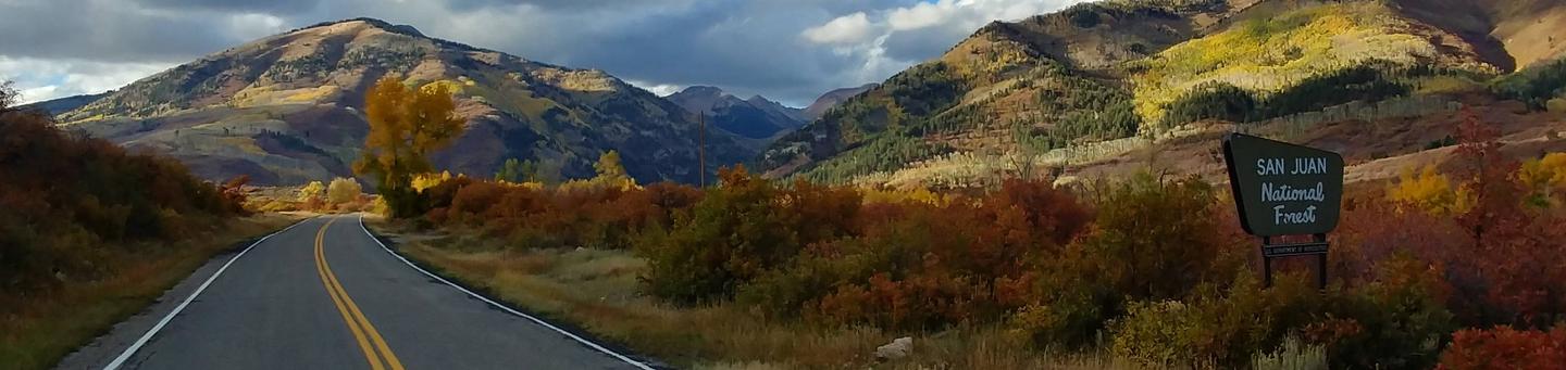
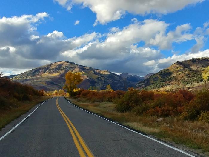
The San Juan National Forest includes approximately 1.8 million acres of federal lands administered by the U.S. Forest Service in Southwestern Colorado. The scenery ranges from high desert mesas and canyons to high alpine peaks and meadows. The area features a National Forest scenic byway, the San Juan Skyway and a Bureau of Land Management 4WD scenic byway, Alpine Loop Backcountry Byway.
Visitors can enjoy a variety of outdoor activities including hiking, mountain biking, hunting, fishing, alpine and nordic skiing, horseback riding, and camping. Come and enjoy the natural splendor of the San Juan Mountains and your public lands!
The San Juan National Forest shares management of three designated Wilderness areas: the Weminuche Wilderness, The Lizard Head Wilderness and the South San Juan Wilderness. For more information visit our Wilderness page.
To order maps and guide books, or for information on educational and volunteer programs, please visit the San Juan Mountains Association website at www.sjma.org.
Use the sidebar menus, on the left or right, to find information on a specific area or activity.
The San Juan National Forest has released a draft Recreation Site Analysis and Plan of Work for public review and feedback.
Recreation Site Analysis Page
RecAreaDirections
Open with Google Map
Misc
| Stay Limit | |
| Reservable | false |
| Keywords | |
| Map Link | |
| Contact Phone | |
| Contact Email |
Permits info
Facilities
Bridge Campground
List of CampsitesOverview
This location is available on a first-come, first-served basis only. Visitors are required to physically arrive at the campground to purchase and claim a site. Once on-site, you may be able to pay for your campsite(s) by scanning a QR code using the Recreation.gov mobile app, and the Scan and Pay feature.
If this option is available, you will need to first download the free Recreation.gov mobile app https://www.recreation.gov/mobile-app prior to your arrival as some remote areas have limited or no cellular service.
Burro Bridge Campground
List of CampsitesOverview
This location is available on a first-come, first-served basis only. Visitors are required to physically arrive at the campground to purchase and claim a site. Once on-site, you may be able to pay for your campsite(s) by scanning a QR code using the Recreation.gov mobile app, and the Scan and Pay feature.
If this option is available, you will need to first download the free Recreation.gov mobile app https://www.recreation.gov/mobile-app prior to your arrival as some remote areas have limited or no cellular service.
Cimarrona (CO) Campground
List of CampsitesOverview
This location is available on a first-come, first-served basis only. Visitors are required to physically arrive at the campground to purchase and claim a site. Once on-site, you may be able to pay for your campsite(s) by scanning a QR code using the Recreation.gov mobile app, and the Scan and Pay feature.
If this option is available, you will need to first download the free Recreation.gov mobile app https://www.recreation.gov/mobile-app prior to your arrival as some remote areas have limited or no cellular service.
Kroeger Campground
List of CampsitesOverview
This location is available on a first-come, first-served basis only. Visitors are required to physically arrive at the campground to purchase and claim a site. Once on-site, you may be able to pay for your campsite(s) by scanning a QR code using the Recreation.gov mobile app, and the Scan and Pay feature.
If this option is available, you will need to first download the free Recreation.gov mobile app https://www.recreation.gov/mobile-app prior to your arrival as some remote areas have limited or no cellular service.
Lower Piedra Campground
List of CampsitesOverview
This location is available on a first-come, first-served basis only. Visitors are required to physically arrive at the campground to purchase and claim a site. Once on-site, you may be able to pay for your campsite(s) by scanning a QR code using the Recreation.gov mobile app, and the Scan and Pay feature.
If this option is available, you will need to first download the free Recreation.gov mobile app https://www.recreation.gov/mobile-app prior to your arrival as some remote areas have limited or no cellular service.
Middle Mountain Campground
List of CampsitesOverview
This location is available on a first-come, first-served basis only. Visitors are required to physically arrive at the campground to purchase and claim a site. Once on-site, you may be able to pay for your campsite(s) by scanning a QR code using the Recreation.gov mobile app, and the Scan and Pay feature.
If this option is available, you will need to first download the free Recreation.gov mobile app https://www.recreation.gov/mobile-app prior to your arrival as some remote areas have limited or no cellular service.
Miller Creek Campground
List of CampsitesOverview
This location is available on a first-come, first-served basis only. Visitors are required to physically arrive at the campground to purchase and claim a site. Once on-site, you may be able to pay for your campsite(s) by scanning a QR code using the Recreation.gov mobile app, and the Scan and Pay feature.
If this option is available, you will need to first download the free Recreation.gov mobile app https://www.recreation.gov/mobile-app prior to your arrival as some remote areas have limited or no cellular service.
Pine River Campground
List of CampsitesOverview
This location is available on a first-come, first-served basis only. Visitors are required to physically arrive at the campground to purchase and claim a site. Once on-site, you may be able to pay for your campsite(s) by scanning a QR code using the Recreation.gov mobile app, and the Scan and Pay feature.
If this option is available, you will need to first download the free Recreation.gov mobile app https://www.recreation.gov/mobile-app prior to your arrival as some remote areas have limited or no cellular service.
Snowslide Campground
List of CampsitesOverview
This location is available on a first-come, first-served basis only. Visitors are required to physically arrive at the campground to purchase and claim a site. Once on-site, you may be able to pay for your campsite(s) by scanning a QR code using the Recreation.gov mobile app, and the Scan and Pay feature.
If this option is available, you will need to first download the free Recreation.gov mobile app https://www.recreation.gov/mobile-app prior to your arrival as some remote areas have limited or no cellular service.
South Mineral Campground
List of CampsitesOverview
This location is available on a first-come, first-served basis only. Visitors are required to physically arrive at the campground to purchase and claim a site. Once on-site, you may be able to pay for your campsite(s) by scanning a QR code using the Recreation.gov mobile app, and the Scan and Pay feature.
If this option is available, you will need to first download the free Recreation.gov mobile app https://www.recreation.gov/mobile-app prior to your arrival as some remote areas have limited or no cellular service.
Teal Campground
List of CampsitesOverview
This location is available on a first-come, first-served basis only. Visitors are required to physically arrive at the campground to purchase and claim a site. Once on-site, you may be able to pay for your campsite(s) by scanning a QR code using the Recreation.gov mobile app, and the Scan and Pay feature.
If this option is available, you will need to first download the free Recreation.gov mobile app https://www.recreation.gov/mobile-app prior to your arrival as some remote areas have limited or no cellular service.
Transfer Park Campground Campground
List of CampsitesOverview
This location is available on a first-come, first-served basis only. Visitors are required to physically arrive at the campground to purchase and claim a site. Once on-site, you may be able to pay for your campsite(s) by scanning a QR code using the Recreation.gov mobile app, and the Scan and Pay feature.
If this option is available, you will need to first download the free Recreation.gov mobile app https://www.recreation.gov/mobile-app prior to your arrival as some remote areas have limited or no cellular service.
CHRIS PARK Campground
List of CampsitesOverview
Chris Park is located near Haviland Lake in southwestern Colorado, 18 miles north of Durango. Visitors enjoy the area for its hiking, canoeing and fishing opportunities.Recreation
Several trailheads are in the vicinity, including Forebay, Goulding, Elbert Creek and Purgatory Flats. The historic Rico-to-Rockwood Wagon Road passes through Chris Park. Built in the late 1800s, the road was used for six years until the railway opened.Facilities
The campground offers three group sites. Sites 1 and 2 can accommodate up to 75 people each. Site 3 can accommodate up to 150 people, and includes a picnic shelter with electricity and grills. A volleyball court is located near this site as well. Picnic tables and campfire rings provided, as are vault toilets and drinking water.Natural Features
The campground is situated in a mostly flat, open area, shaded by scattered ponderosa pine trees. Haviland Lake is a short drive from the site.Nearby Attractions
Beautiful Haviland Lake is less than two miles from the campground. The 80-acre, no-wake lake offers boating, canoeing and fishing. Accessible fishing docks are located on the lakeshore.Charges & Cancellations
Group Sites
Group Facility (including Cabins and Lookouts): A visitor who cancels a group overnight facility reservation less than 14 days before the arrival date will pay a $10.00 service fee AND forfeit the first night's use fee.
No-Shows
A no-show visitor is one who does not arrive at a campground and does not cancel the reservation by check-out time on the day after the scheduled arrival date. Staff will hold a campsite until check-out time on the day following the arrival date.
No-shows are assessed $20.00 service fee and forfeit the first night's rate, taxes and applicable add-on for a campsite.
Refunds
Visitors may submit a refund request through their Recreation.gov profile within 7 days of the end date of their reservation. Refunds will not be issued after the 7 days has ended.
Refunds for debit or credit card payments will be issued as a credit to the original bank or credit card used to pay.
For check or cash purchases, Recreation.gov will mail a Treasury check for refunds of cash, check, or money order payments to the address associated with the reservation. Treasury check refunds may take up to 6-8 weeks to arrive.
In the event of an emergency closure, the Recreation.gov team or facility manager will refund all fees and will attempt to notify you using the contact information within the Recreation.gov visitor profile.
HOUSE CREEK Campground
List of CampsitesOverview
House Creek Campground is located on the shores of McPhee Reservoir near the town of Dolores in southwestern Colorado. Visitors enjoy the area for its boating, water skiing and fishing opportunities.Recreation
McPhee Reservoir, the largest within the San Juan National Forest and second largest in Colorado, has 50 miles of shoreline. Boating, water skiing, swimming and fishing are popular activities. A boat ramp is located within the campground.Facilities
The campground offers group and single-family sites, some of which have electric hookups. Several sites have shelters for shade. Picnic tables, campfire rings and grills are provided, as are vault toilets and drinking water.Natural Features
The campground is situated in a gently sloping meadow near the reservoir's high-water line. The is no shade and the area is hot during summer.Nearby Attractions
Southwestern Colorado, part of the Four Corners region, contains more than 4,000 archaeological sites and more than 600 cliff dwellings. Many sites offer glimpses of the ancient Anasazi culture, for which this area is known.Anasazi Heritage Center is 30 minutes northwest of Dolores. Mesa Verde National Park is an hour and a half drive south of the campground. Canyon of the Ancients is an hour and a half hours southwest. Hovenweep National Monument is an hour and 45 minutes west.
Charges & Cancellations
Cancellations
Individual Campsites: Cancellations up to 2 days before a reservation start date incur a $10.00 cancellation fee.
A visitor who cancels a reservation the day before or on the day of arrival will pay a $10.00 service fee AND forfeit the first night's use fee including tax and applicable add-on for a campsite.
Cancellations for a one-night reservation will forfeit the entire amount paid and will not be subject to an additional service fee.
No-Shows
A no-show visitor is one who does not arrive at a campground and does not cancel the reservation by check-out time on the day after the scheduled arrival date. Staff will hold a campsite until check-out time on the day following the arrival date.
No-shows are assessed $20.00 service fee and forfeit the first night's rate, taxes and applicable add-on for a campsite.
Refunds
Visitors may submit a refund request through their Recreation.gov profile within 7 days of the end date of their reservation. Refunds will not be issued after the 7 days has ended.
Refunds for debit or credit card payments will be issued as a credit to the original bank or credit card used to pay.
For check or cash purchases, Recreation.gov will mail a Treasury check for refunds of cash, check, or money order payments to the address associated with the reservation. Treasury check refunds may take up to 6-8 weeks to arrive.
In the event of an emergency closure, the Recreation.gov team or facility manager will refund all fees and will attempt to notify you using the contact information within the Recreation.gov visitor profile.
MCPHEE RECREATION COMPLEX Campground
List of CampsitesOverview
McPhee Recreation Complex is located on the south shore of McPhee Reservoir near the town of Dolores in southwestern Colorado. Visitors enjoy the area for its boating, water skiing and fishing opportunities.Recreation
McPhee Reservoir, the largest within the San Juan National Forest and second-largest in Colorado, has 50 miles of shoreline. Boating, water skiing and fishing are popular activities. A boat ramp and fish cleaning station are located within the complex.The half-mile Can Do Trail climbs to a scenic overlook with panoramic views of the reservoir and the beautiful peaks surrounding Mesa Verde to the south.
Facilities
This large campground offers group sites, RV and tent sites, some of which have electric hookups. Several sites have shelters for shade. Picnic tables and campfire rings are provided, as are flush toilets.Natural Features
The campground is situated on a mesa 500 feet above the reservoir, at an elevation of 7,400 feet. Pinyon and juniper trees offer shade throughout the campground.Nearby Attractions
Southwestern Colorado, part of the Four Corners region, contains more than 4,000 archaeological sites and more than 600 cliff dwellings. Many sites offer glimpses of the ancient Anasazi culture for which the area is known.Anasazi Heritage Center is 10 minutes away in Dolores. Mesa Verde National Park is one hour south of the campground. The Canyon of the Ancients is an hour southwest and Hovenweep National Monument is an hour west.
Charges & Cancellations
Cancellations
Individual Campsites: Cancellations up to 2 days before a reservation start date incur a $10.00 cancellation fee.
A visitor who cancels a reservation the day before or on the day of arrival will pay a $10.00 service fee AND forfeit the first night's use fee including tax and applicable add-on for a campsite.
Cancellations for a one-night reservation will forfeit the entire amount paid and will not be subject to an additional service fee.
Group Sites
Group Facility (including Cabins and Lookouts): A visitor who cancels a group overnight facility reservation less than 14 days before the arrival date will pay a $10.00 service fee AND forfeit the first night's use fee.
No-Shows
A no-show visitor is one who does not arrive at a campground and does not cancel the reservation by check-out time on the day after the scheduled arrival date. Staff will hold a campsite until check-out time on the day following the arrival date.
No-shows are assessed $20.00 service fee and forfeit the first night's rate, taxes and applicable add-on for a campsite.
Refunds
Visitors may submit a refund request through their Recreation.gov profile within 7 days of the end date of their reservation. Refunds will not be issued after the 7 days has ended.
Refunds for debit or credit card payments will be issued as a credit to the original bank or credit card used to pay.
For check or cash purchases, Recreation.gov will mail a Treasury check for refunds of cash, check, or money order payments to the address associated with the reservation. Treasury check refunds may take up to 6-8 weeks to arrive.
In the event of an emergency closure, the Recreation.gov team or facility manager will refund all fees and will attempt to notify you using the contact information within the Recreation.gov visitor profile.
FLORIDA CAMPGROUND (CO) Campground
List of CampsitesOverview
Florida Campground is located near the north end of Lemon Reservoir, in southwestern Colorado. Visitors enjoy the area for its fishing, trail opportunities and scenic natural setting.Recreation
The Florida River is well known for its rainbow and brown trout fishing, but the river runs through much private land, so anglers should be careful not to trespass.Hiking and biking are popular activities in the area. The Burnt Timber Trail No. 667 begins at Transfer Park, about a mile north of the campground.
The East Florida Road (Forest Road 597) winds steeply uphill past the campground. Lost Lake and Stump Lake Trails begin along this road, offering short, easy hikes to backcountry lakes.
The surrounding area is open to public hunting. Deer, elk and small game such as rabbits and grouse inhabit the forest.
Facilities
The campground offers one group site, equipped with picnic and serving tables, as well as campfire rings with grills. Vault toilets and drinking water are provided.Natural Features
This lightly used campground is situated in a shady forest of Colorado blue spruce, Douglas fir and aspen trees. The swift Florida River flows next to the campground.Nearby Attractions
Lemon Reservoir is about three miles from the campground, offering boating, water skiing and fishing opportunities. The reservoir is stocked with rainbow trout and kokanee salmon. Many visitors take advantage of Colorado's Free Fishing Days, held annually the first full weekend of June.Young's Canyon Trail No. 546 begins at the north end of the reservoir. Hikers must cross the Florida River to access the trail; crossing is tricky during high water. The trail is very popular during hunting season.
Charges & Cancellations
Group Sites
Group Facility (including Cabins and Lookouts): A visitor who cancels a group overnight facility reservation less than 14 days before the arrival date will pay a $10.00 service fee AND forfeit the first night's use fee.
No-Shows
A no-show visitor is one who does not arrive at a campground and does not cancel the reservation by check-out time on the day after the scheduled arrival date. Staff will hold a campsite until check-out time on the day following the arrival date.
No-shows are assessed $20.00 service fee and forfeit the first night's rate, taxes and applicable add-on for a campsite.
Refunds
Visitors may submit a refund request through their Recreation.gov profile within 7 days of the end date of their reservation. Refunds will not be issued after the 7 days has ended.
Refunds for debit or credit card payments will be issued as a credit to the original bank or credit card used to pay.
For check or cash purchases, Recreation.gov will mail a Treasury check for refunds of cash, check, or money order payments to the address associated with the reservation. Treasury check refunds may take up to 6-8 weeks to arrive.
In the event of an emergency closure, the Recreation.gov team or facility manager will refund all fees and will attempt to notify you using the contact information within the Recreation.gov visitor profile.
GRAHAM CREEK CAMPGROUND Campground
List of CampsitesOverview
Graham Creek Campground is situated above Vallecito Lake, in the scenic San Juan National Forest of southwestern Colorado. Visitors enjoy the area for its beautiful scenery and wide range of recreational activities, including boating, fishing and hiking.Recreation
Vallecito Lake is a very popular fishing destination, where anglers cast for German brown trout, cutthroat trout, rainbow trout, kokanee salmon and northern pike.The lake offers great boating, water skiing and canoeing opportunities. Boat rentals and fishing licenses are available at various locations around the lake.
A variety of hiking and horseback riding trails are found in the area. The North Canyon Trail begins across the road from the campground and leads through ponderosa pine and aspen forests on its way through the canyon. A shorter trail leads to a scenic overlook of the lake.
East Creek Trail begins a quarter-mile up Forest Road 852, just northeast of the campground. The trail provides access to a lightly used, scenic drainage where fly-fisherman cast for brook trout. Both trails are popular with horseback riders, however, horses are not allowed in the campground.
Facilities
The campground offers single-family campsites, a few of which have lake views. Sites are each equipped with a picnic table and campfire ring. Vault toilets and drinking water are provided. The south side of the campground is adjacent to private property.Natural Features
Vallecito Lake, Spanish for "little valley," sits at an elevation of 7,900 feet. Scattered ponderosa pine trees tower over the open campground, offering limited shade. Hillside sites are about 100 yards from the high-water line and offer nice lake views.A thick understory provides privacy between sites. Thickets of willow separate the camping area from the lakeshore. Several short trails lead to the lake from the campground. High peaks of the San Juans are visible to the northwest of the campground.
Charges & Cancellations
Cancellations
Individual Campsites: Cancellations up to 2 days before a reservation start date incur a $10.00 cancellation fee.
A visitor who cancels a reservation the day before or on the day of arrival will pay a $10.00 service fee AND forfeit the first night's use fee including tax and applicable add-on for a campsite.
Cancellations for a one-night reservation will forfeit the entire amount paid and will not be subject to an additional service fee.
No-Shows
A no-show visitor is one who does not arrive at a campground and does not cancel the reservation by check-out time on the day after the scheduled arrival date. Staff will hold a campsite until check-out time on the day following the arrival date.
No-shows are assessed $20.00 service fee and forfeit the first night's rate, taxes and applicable add-on for a campsite.
Refunds
Visitors may submit a refund request through their Recreation.gov profile within 7 days of the end date of their reservation. Refunds will not be issued after the 7 days has ended.
Refunds for debit or credit card payments will be issued as a credit to the original bank or credit card used to pay.
For check or cash purchases, Recreation.gov will mail a Treasury check for refunds of cash, check, or money order payments to the address associated with the reservation. Treasury check refunds may take up to 6-8 weeks to arrive.
In the event of an emergency closure, the Recreation.gov team or facility manager will refund all fees and will attempt to notify you using the contact information within the Recreation.gov visitor profile.
CAYTON CAMPGROUND Campground
List of CampsitesOverview
Cayton Campground is located along the San Juan Skyway (Colorado Highway 145) and the Dolores River. Visitors enjoy the area for its great fishing, hiking and scenic driving opportunities.Recreation
The Dolores River is a popular fishing destination that can often be crowded on summer weekends. Anglers will find rainbow, brown and cutthroat trout.The area boasts some excellent trails. The Colorado Trail follows the ridge across Bolam Pass. The Lizard Head and Cross Mountain Trails near Lizard Head Pass lead to alpine basins surrounded by 14,000-foot peaks.
The Barlow Creek Road continues past the campground and crosses Bolam Pass with spectacular views. Road conditions near the pass often limit travel to four-wheel drive vehicles. The route eventually connects with the Hermosa Park Road, behind Durango Mountain Resort, and leads to U.S. Highway 550.
Facilities
The campground offers 27 single-family campsites, many of which are situated along the river. Eighteen sites offer electric hookups. Each site is equipped with a picnic table and campfire ring. Vault toilets, drinking water and a dump station are provided.Natural Features
The campground is situated near the banks of the Dolores River, in a grassy meadow surrounded by fir and aspen trees. At an elevation of 9,400 feet, campers should expect cool evenings.Nearby Attractions
The Priest Gulch Trailhead, 11 miles southwest of Rico, leads to the alpine country west of the campground. The Bear Creek Trail, 14 miles south of Rico, heads southeast into the La Plata Mountains. Other nearby trails include the Calico National Recreation Trail and the Rico-Silverton Trail.Highway 145, which runs between the campground and Telluride, offers some of the most majestic scenery along the San Juan Skyway, including views of the "14ers," which are peaks over 14,000 feet.
Charges & Cancellations
Cancellations
Individual Campsites: Cancellations up to 2 days before a reservation start date incur a $10.00 cancellation fee.
A visitor who cancels a reservation the day before or on the day of arrival will pay a $10.00 service fee AND forfeit the first night's use fee including tax and applicable add-on for a campsite.
Cancellations for a one-night reservation will forfeit the entire amount paid and will not be subject to an additional service fee.
No-Shows
A no-show visitor is one who does not arrive at a campground and does not cancel the reservation by check-out time on the day after the scheduled arrival date. Staff will hold a campsite until check-out time on the day following the arrival date.
No-shows are assessed $20.00 service fee and forfeit the first night's rate, taxes and applicable add-on for a campsite.
Refunds
Visitors may submit a refund request through their Recreation.gov profile within 7 days of the end date of their reservation. Refunds will not be issued after the 7 days has ended.
Refunds for debit or credit card payments will be issued as a credit to the original bank or credit card used to pay.
For check or cash purchases, Recreation.gov will mail a Treasury check for refunds of cash, check, or money order payments to the address associated with the reservation. Treasury check refunds may take up to 6-8 weeks to arrive.
In the event of an emergency closure, the Recreation.gov team or facility manager will refund all fees and will attempt to notify you using the contact information within the Recreation.gov visitor profile.
WEST DOLORES CAMPGROUND Campground
List of CampsitesOverview
West Dolores Campground is located on the West Dolores Road (Forest Road 535), which branches north from Colorado Highway 145 about 20 miles northeast of Dolores. It is a great place to relax and enjoy the outdoors by hiking, biking and fishing.Recreation
The West Dolores River offers fishing for brown, rainbow, cutthroat and brook trout. A day-use parking area is available on-site. Several parcels of private property are found along the river. Visitors are asked to stay on the trail and not trespass.Mountain biking is allowed on Forest Roads 532 and 535. Forest Service Trail 624 begins three miles south of the campground.
Facilities
The campground offers single-family sites, a few of which have electric hookups. Each site is equipped with a picnic table and campfire ring. Vault toilets and drinking water are provided.Natural Features
The campground is situated on the banks of the West Dolores River, which has its headwaters in the nearby Lizard Head Wilderness. A shady forest of spruce, ponderosa pine and Douglas fir covers the campground. The campground is at an elevation of 7,800 feet.Nearby Attractions
Southwestern Colorado, part of the Four Corners region, contains more than 4,000 archaeological sites and 600 cliff dwellings. Mesa Verde National Park is an hour and a half south of the campground, close enough for a day trip. Other sites within the region include the Anasazi Heritage Center in Delores, Canyon of the Ancients and Hovenweep National Monument.Burro Bridge campground is loacated 19 miles north of the campground offering Horse camping and a trail from the campground into the Lizard Head Wilderness.
Charges & Cancellations
Cancellations
Individual Campsites: Cancellations up to 2 days before a reservation start date incur a $10.00 cancellation fee.
A visitor who cancels a reservation the day before or on the day of arrival will pay a $10.00 service fee AND forfeit the first night's use fee including tax and applicable add-on for a campsite.
Cancellations for a one-night reservation will forfeit the entire amount paid and will not be subject to an additional service fee.
No-Shows
A no-show visitor is one who does not arrive at a campground and does not cancel the reservation by check-out time on the day after the scheduled arrival date. Staff will hold a campsite until check-out time on the day following the arrival date.
No-shows are assessed $20.00 service fee and forfeit the first night's rate, taxes and applicable add-on for a campsite.
Refunds
Visitors may submit a refund request through their Recreation.gov profile within 7 days of the end date of their reservation. Refunds will not be issued after the 7 days has ended.
Refunds for debit or credit card payments will be issued as a credit to the original bank or credit card used to pay.
For check or cash purchases, Recreation.gov will mail a Treasury check for refunds of cash, check, or money order payments to the address associated with the reservation. Treasury check refunds may take up to 6-8 weeks to arrive.
In the event of an emergency closure, the Recreation.gov team or facility manager will refund all fees and will attempt to notify you using the contact information within the Recreation.gov visitor profile.
HAVILAND LAKE CAMPGROUND Campground
List of CampsitesOverview
Haviland Lake Campground is situated on its beautiful namesake within the San Juan National Forest, 18 miles north of Durango. Visitors enjoy the area for its canoeing, fishing and hiking opportunities in a scenic, natural setting. The popular campground is beautiful any time of the year.Recreation
Haviland Lake is an 80-acre, no-wake lake with excellent boating, canoeing and fishing opportunities. An accessible fishing dock is located on the lakeshore. Anglers cast for rainbow and brown trout. A Colorado Division of Wildlife fishing license is required to fish.Several trailheads are in the vicinity. The Forebay Lake Trail begins in the campground and leads to small Forebay Lake, just over a mile east of the campground.
The historic Rico-to-Rockwood Wagon Road passes through Haviland and Chris Park. Built in the late 1800s, the road was used for six years until the railway opened.
Facilities
The campground offers single- and double-family sites, many of which have electric hookups. Picnic tables and campfire rings are provided, as are accessible vault toilets and drinking water.Natural Features
The campground is situated on the shore of Haviland Lake, among shady, towering ponderosa pines, at an elevation of 8,705 feet. Many sites have lake views and easy shoreline access. Campers are awarded spectacular views of the Hermosa Cliffs across the lake.Charges & Cancellations
Cancellations
Individual Campsites: Cancellations up to 2 days before a reservation start date incur a $10.00 cancellation fee.
A visitor who cancels a reservation the day before or on the day of arrival will pay a $10.00 service fee AND forfeit the first night's use fee including tax and applicable add-on for a campsite.
Cancellations for a one-night reservation will forfeit the entire amount paid and will not be subject to an additional service fee.
No-Shows
A no-show visitor is one who does not arrive at a campground and does not cancel the reservation by check-out time on the day after the scheduled arrival date. Staff will hold a campsite until check-out time on the day following the arrival date.
No-shows are assessed $20.00 service fee and forfeit the first night's rate, taxes and applicable add-on for a campsite.
Refunds
Visitors may submit a refund request through their Recreation.gov profile within 7 days of the end date of their reservation. Refunds will not be issued after the 7 days has ended.
Refunds for debit or credit card payments will be issued as a credit to the original bank or credit card used to pay.
For check or cash purchases, Recreation.gov will mail a Treasury check for refunds of cash, check, or money order payments to the address associated with the reservation. Treasury check refunds may take up to 6-8 weeks to arrive.
In the event of an emergency closure, the Recreation.gov team or facility manager will refund all fees and will attempt to notify you using the contact information within the Recreation.gov visitor profile.
NORTH CANYON CAMPGROUND Campground
List of CampsitesOverview
North Canyon Campground is situated next to Vallecito Reservoir in southwestern Colorado. Visitors enjoy the area for its beautiful scenery and wide range of recreational activities, including boating, fishing and hiking.Recreation
Vallecito Reservoir is a very popular fishing lake, with anglers casting for German brown trout, cutthroat trout, rainbow trout, kokanee salmon and northern pike.The lake offers great boating, water skiing and canoeing opportunities. Boat rentals and fishing licenses are available at various locations around the lake.
A variety of hiking and horseback riding trails are found in the area. The North Canyon Trail begins across the road from the campground and leads through ponderosa pine and aspen forests. A short side trail leads to a scenic overlook of the lake.
East Creek Trail begins a quarter-mile northeast of the campground, on Forest Road 852. It provides access to a lightly used, scenic drainage where fly-fisherman cast for brook trout. Both trails are popular with horseback riders, however, horses are not allowed in the campground.
Facilities
The campground offers single-family sites, many of which have lake views. Sites are equipped with a picnic table and campfire ring. Vault toilets and drinking water are provided.Natural Features
Vallecito, which is Spanish for "little valley," sits at an elevation of 7,900 feet. Scattered ponderosa pines tower over the open campground, offering limited shade. A thick understory provides privacy between sites, many of which have partial lake views. Thickets of willow separate the camping area from the lakeshore. High peaks of the San Juans are visible to the northwest of the campground.Charges & Cancellations
Cancellations
Individual Campsites: Cancellations up to 2 days before a reservation start date incur a $10.00 cancellation fee.
A visitor who cancels a reservation the day before or on the day of arrival will pay a $10.00 service fee AND forfeit the first night's use fee including tax and applicable add-on for a campsite.
Cancellations for a one-night reservation will forfeit the entire amount paid and will not be subject to an additional service fee.
No-Shows
A no-show visitor is one who does not arrive at a campground and does not cancel the reservation by check-out time on the day after the scheduled arrival date. Staff will hold a campsite until check-out time on the day following the arrival date.
No-shows are assessed $20.00 service fee and forfeit the first night's rate, taxes and applicable add-on for a campsite.
Refunds
Visitors may submit a refund request through their Recreation.gov profile within 7 days of the end date of their reservation. Refunds will not be issued after the 7 days has ended.
Refunds for debit or credit card payments will be issued as a credit to the original bank or credit card used to pay.
For check or cash purchases, Recreation.gov will mail a Treasury check for refunds of cash, check, or money order payments to the address associated with the reservation. Treasury check refunds may take up to 6-8 weeks to arrive.
In the event of an emergency closure, the Recreation.gov team or facility manager will refund all fees and will attempt to notify you using the contact information within the Recreation.gov visitor profile.
WEST FORK CAMPGROUND Campground
List of CampsitesOverview
West Fork Campground sits near the West Fork San Juan River in a secluded 10-acre area, just over a mile from Highway 160. Visitors enjoy the area for its hiking opportunities and plentiful solitude.Recreation
The West Fork and nearby Wolf Creek offer fishing opportunities, but are heavily fished streams. Only skilled and patient fishermen have much luck in these waters.The West Fork Trail, also known as the Rainbow Trail, leads into the Weminuche Wilderness from a trailhead a mile beyond the campground. The first portion of the trail passes through private property, so please stay on the trail and leave the gates as you find them.
Facilities
The campground offers single-family sites, some of which are adjacent to the river but without direct views. Most sites are suitable for large RVs. Picnic tables and campfire rings are provided, as are vault toilets and drinking water.Natural Features
The campground is situated among a forest of mixed conifers, where sites have sun and shade. The West Fork can be heard, but not seen from the campground.Nearby Attractions
Trailheads for Windy Pass and Treasure Mountain Trails are located across Highway 160 from the West Fork Road turnoff.Treasure Falls, located off Highway 160 about three miles from the campground, is an impressive 100-foot waterfall with a short hike leading to its base.
Charges & Cancellations
Cancellations
Individual Campsites: Cancellations up to 2 days before a reservation start date incur a $10.00 cancellation fee.
A visitor who cancels a reservation the day before or on the day of arrival will pay a $10.00 service fee AND forfeit the first night's use fee including tax and applicable add-on for a campsite.
Cancellations for a one-night reservation will forfeit the entire amount paid and will not be subject to an additional service fee.
No-Shows
A no-show visitor is one who does not arrive at a campground and does not cancel the reservation by check-out time on the day after the scheduled arrival date. Staff will hold a campsite until check-out time on the day following the arrival date.
No-shows are assessed $20.00 service fee and forfeit the first night's rate, taxes and applicable add-on for a campsite.
Refunds
Visitors may submit a refund request through their Recreation.gov profile within 7 days of the end date of their reservation. Refunds will not be issued after the 7 days has ended.
Refunds for debit or credit card payments will be issued as a credit to the original bank or credit card used to pay.
For check or cash purchases, Recreation.gov will mail a Treasury check for refunds of cash, check, or money order payments to the address associated with the reservation. Treasury check refunds may take up to 6-8 weeks to arrive.
In the event of an emergency closure, the Recreation.gov team or facility manager will refund all fees and will attempt to notify you using the contact information within the Recreation.gov visitor profile.
East Fork Campground (San Juan NF - CO) Campground
List of CampsitesOverview
East Fork Campground is located 11 miles northeast of Pagosa Springs, just off U.S. Highway 160, along the East Fork Road. Visitors enjoy the area for its fishing, hiking and scenic opportunities.Recreation
The East Fork offers plenty of fishing opportunities upstream from the campground. Trailheads for the Coal Creek Trail and the Quartz Ridge Trail are at Sand Creek, 2-5 miles beyond the campground.Facilities
The campground offers several single-family sites, many with views of the river below. There are a few level pull-through parking spaces for RVs. Accessible vault toilets and drinking water are provided.Natural Features
The campground sits on a ridge overlooking the East Fork of the San Juan River. Some sites have views of the river, but it's a long way down the hill. Short, but steep trails lead down the hill, to the riverbanks. A forest of ponderosa pine and gambel oak trees shades the campground. At 7,700 feet, temperatures can be a bit warmer than at surrounding campgrounds.Nearby Attractions
Silver Falls is located a few miles up East Fork Road past the campground. A short trail leads to the base of the falls. Mountain bikers often ride to Silver Falls. Beyond its junction with Forest Road 684, the East Fork Road is negotiable only by 4WD. Off-road vehicle enthusiasts enjoy the upper section to Elwood Pass.Treasure Falls, located just off Highway 160 about five miles from the campground, is an impressive 100' waterfall with a short hike.
Charges & Cancellations
Cancellations
Individual Campsites: Cancellations up to 2 days before a reservation start date incur a $10.00 cancellation fee.
A visitor who cancels a reservation the day before or on the day of arrival will pay a $10.00 service fee AND forfeit the first night's use fee including tax and applicable add-on for a campsite.
Cancellations for a one-night reservation will forfeit the entire amount paid and will not be subject to an additional service fee.
No-Shows
A no-show visitor is one who does not arrive at a campground and does not cancel the reservation by check-out time on the day after the scheduled arrival date. Staff will hold a campsite until check-out time on the day following the arrival date.
No-shows are assessed $20.00 service fee and forfeit the first night's rate, taxes and applicable add-on for a campsite.
Refunds
Visitors may submit a refund request through their Recreation.gov profile within 7 days of the end date of their reservation. Refunds will not be issued after the 7 days has ended.
Refunds for debit or credit card payments will be issued as a credit to the original bank or credit card used to pay.
For check or cash purchases, Recreation.gov will mail a Treasury check for refunds of cash, check, or money order payments to the address associated with the reservation. Treasury check refunds may take up to 6-8 weeks to arrive.
In the event of an emergency closure, the Recreation.gov team or facility manager will refund all fees and will attempt to notify you using the contact information within the Recreation.gov visitor profile.
Pine Point (Vallecito Reservoir, CO) Campground
List of CampsitesOverview
Pine Point Campground is situated next to Vallecito Reservoir in southwestern Colorado. Visitors enjoy the area for its beautiful scenery and wide range of recreational activities, including boating, fishing and hiking.Recreation
Vallecito Reservoir is a very popular fishing lake, with anglers casting for German brown trout, cutthroat trout, rainbow trout, kokanee salmon and northern pike. Boating, water skiing and canoeing are popular activities. A sheltered area for boats and an open play area are just south of the campground.A variety of hiking and horseback riding trails are found in the area. The North Canyon Trail climbs through ponderosa pine and aspen forests. A short side trail leads to a scenic overlook of the lake. East Creek Trail provides access to a lightly used, scenic drainage where fly-fisherman can be seen casting for brook trout.
Facilities
The campground offers single-family sites, each equipped with a picnic table and campfire ring. Vault toilets and drinking water are provided.Natural Features
The Vallecito lake, which is Spanish for "little valley," sits at an elevation of 7,900 feet. A scenic forest of ponderosa pine covers the campground, which offers many shaded, lakefront sites with easy access to the shore. High peaks of the San Juan Mountains are visible to the northwest of the campground.Charges & Cancellations
Cancellations
Individual Campsites: Cancellations up to 2 days before a reservation start date incur a $10.00 cancellation fee.
A visitor who cancels a reservation the day before or on the day of arrival will pay a $10.00 service fee AND forfeit the first night's use fee including tax and applicable add-on for a campsite.
Cancellations for a one-night reservation will forfeit the entire amount paid and will not be subject to an additional service fee.
No-Shows
A no-show visitor is one who does not arrive at a campground and does not cancel the reservation by check-out time on the day after the scheduled arrival date. Staff will hold a campsite until check-out time on the day following the arrival date.
No-shows are assessed $20.00 service fee and forfeit the first night's rate, taxes and applicable add-on for a campsite.
Refunds
Visitors may submit a refund request through their Recreation.gov profile within 7 days of the end date of their reservation. Refunds will not be issued after the 7 days has ended.
Refunds for debit or credit card payments will be issued as a credit to the original bank or credit card used to pay.
For check or cash purchases, Recreation.gov will mail a Treasury check for refunds of cash, check, or money order payments to the address associated with the reservation. Treasury check refunds may take up to 6-8 weeks to arrive.
In the event of an emergency closure, the Recreation.gov team or facility manager will refund all fees and will attempt to notify you using the contact information within the Recreation.gov visitor profile.
BLANCO RIVER GROUP CAMPGROUND Campground
List of CampsitesOverview
Blanco River Group Campground is located four miles off U.S. Highway 84, on Forest Road 656. It is about 15 miles southeast of Pagosa Springs, on the Blanco River. The campground is a convenient stopping point between the towns of Chama, N.M., and Pagosa Springs, Colo. Secluded and quiet, the campgound is an ideal place for family and friends to gather.Recreation
The Blanco River can be accessed from the campground, offering good fishing. Anglers cast for stocked trout on the lightly fished waterway.A volleyball court is located within the campground, but campers must bring their own net and ball.
Facilities
The campground offers one group site that is made up of several single campsites. They must be reserved at the same time for group use. Four parking spurs are suitable for large RVs and ample space is available for tents. The campground is equipped with three picnic areas with large tables, vault toilets and drinking water.Natural Features
The campground is situated on the banks of the Blanco River, surrounded by ponderosa pine and cottonwoods. The trees offer shade, but the area is quite warm during the summer months. The riparian environment is fairly level with a few adjacent grassy meadows.Nearby Attractions
Three nearby trails access the roadless area to the east of the campground. The Navajo Peak Trail and V-Rock Trail can be reached from the Buckles Lake Road (Forest Road 663), which is located about seven miles south of the campground via Highway 84. The Blanco Basin Road (Forest Road 657) accesses the Leche Creek Trail.Charges & Cancellations
Group Sites
Group Facility (including Cabins and Lookouts): A visitor who cancels a group overnight facility reservation less than 14 days before the arrival date will pay a $10.00 service fee AND forfeit the first night's use fee.
No-Shows
A no-show visitor is one who does not arrive at a campground and does not cancel the reservation by check-out time on the day after the scheduled arrival date. Staff will hold a campsite until check-out time on the day following the arrival date.
No-shows are assessed $20.00 service fee and forfeit the first night's rate, taxes and applicable add-on for a campsite.
Refunds
Visitors may submit a refund request through their Recreation.gov profile within 7 days of the end date of their reservation. Refunds will not be issued after the 7 days has ended.
Refunds for debit or credit card payments will be issued as a credit to the original bank or credit card used to pay.
For check or cash purchases, Recreation.gov will mail a Treasury check for refunds of cash, check, or money order payments to the address associated with the reservation. Treasury check refunds may take up to 6-8 weeks to arrive.
In the event of an emergency closure, the Recreation.gov team or facility manager will refund all fees and will attempt to notify you using the contact information within the Recreation.gov visitor profile.
PALISADES HORSE CAMP Campground
List of CampsitesOverview
Palisades Horse Camp is located 30 miles north of Pagosa Springs, high in the San Juan National Forest. This beautiful area has excellent horseback riding and hiking trails and an abundance of wildlife.Recreation
Hiking and horseback riding trails are the main attraction at Palisades. The Williams Creek Trail leads directly from the campground into the Weminuche Wilderness, crossing the Continental Divide.Facilities
This equestrian campground offers single- and double-family campsites to campers with horses. Corrals with feeding bins are provided. The corrals are divided into two sections with room for two to three horses on each side, depending on horse temperaments. Hitching racks are set up throughout the campground and a water tank is on-site.Vault toilets and drinking water are provided. A campground host is on-site, and is very knowledgeable about the area.
Natural Features
The campground is nestled in a stand of pine, spruce and fir trees, and sits at an elevation of 8,300 feet. The area provides panoramic views of the surrounding meadows and mountains. Williams Creek flows nearby.The surrounding forest provides a prime wildlife habitat. Bears, deer, elk and moose frequent the area.
Charges & Cancellations
Cancellations
Individual Campsites: Cancellations up to 2 days before a reservation start date incur a $10.00 cancellation fee.
A visitor who cancels a reservation the day before or on the day of arrival will pay a $10.00 service fee AND forfeit the first night's use fee including tax and applicable add-on for a campsite.
Cancellations for a one-night reservation will forfeit the entire amount paid and will not be subject to an additional service fee.
No-Shows
A no-show visitor is one who does not arrive at a campground and does not cancel the reservation by check-out time on the day after the scheduled arrival date. Staff will hold a campsite until check-out time on the day following the arrival date.
No-shows are assessed $20.00 service fee and forfeit the first night's rate, taxes and applicable add-on for a campsite.
Refunds
Visitors may submit a refund request through their Recreation.gov profile within 7 days of the end date of their reservation. Refunds will not be issued after the 7 days has ended.
Refunds for debit or credit card payments will be issued as a credit to the original bank or credit card used to pay.
For check or cash purchases, Recreation.gov will mail a Treasury check for refunds of cash, check, or money order payments to the address associated with the reservation. Treasury check refunds may take up to 6-8 weeks to arrive.
In the event of an emergency closure, the Recreation.gov team or facility manager will refund all fees and will attempt to notify you using the contact information within the Recreation.gov visitor profile.
TARGET TREE CAMPGROUND Campground
List of CampsitesOverview
Target Tree Campground is located 7 miles east of Mancos on the north side of Highway 160 at an elevation of 7,643 feet. It is the ideal camping spot for day trips to Mancos, Durango and Mesa Verde National Park.The name, "Target Tree," refers to the Ute Indians' use of the area to harvest sap and bark from Ponderosa pines as food supplements. They also used the trees for target practice, leaving several scarred trees throughout the area.
Recreation
Visitors may enjoy taking a short, accessible interpretive trail to view a historic target tree. The campground is also known for its great birding opportunities, with a sign in the campground that lists species found in the area.The Narrow Gauge Trail begins within the campground and climbs 3.4 miles to an old railroad grade. The rails were placed just three feet apart to allow trains to navigate through the rugged mountains.
Facilities
The campground offers single-family sites, many of which meet accessibility standards and are equipped with a picnic table and campfire ring.A group site can accommodate up to 50 people and 10 vehicles. It also offers two divided corrals for those camping with horses. The site contains two pull-through sites and four parallel sites for RVs.
Vault toilets, drinking water and trash collection are provided.
Natural Features
The campground sits on a south-facing hillside overlooking Thompson Park. A Ponderosa pine and Gambel oak forest provides shade in many sites. The area is hot during the summer, but cools off significantly at night.Nearby Attractions
Southwestern Colorado, part of the Four Corners region, contains over 4,000 archaeological sites and over 600 cliff dwellings. Mesa Verde National Park is 1 hour and 45 minutes south, close enough for a day trip. Other sites within a few hour's drive include the Anasazi Heritage Center in Dolores, Canyon of the Ancients and Hovenweep National Monument.Charges & Cancellations
Cancellations
Individual Campsites: Cancellations up to 2 days before a reservation start date incur a $10.00 cancellation fee.
A visitor who cancels a reservation the day before or on the day of arrival will pay a $10.00 service fee AND forfeit the first night's use fee including tax and applicable add-on for a campsite.
Cancellations for a one-night reservation will forfeit the entire amount paid and will not be subject to an additional service fee.
Group Sites
Group Facility (including Cabins and Lookouts): A visitor who cancels a group overnight facility reservation less than 14 days before the arrival date will pay a $10.00 service fee AND forfeit the first night's use fee.
No-Shows
A no-show visitor is one who does not arrive at a campground and does not cancel the reservation by check-out time on the day after the scheduled arrival date. Staff will hold a campsite until check-out time on the day following the arrival date.
No-shows are assessed $20.00 service fee and forfeit the first night's rate, taxes and applicable add-on for a campsite.
Refunds
Visitors may submit a refund request through their Recreation.gov profile within 7 days of the end date of their reservation. Refunds will not be issued after the 7 days has ended.
Refunds for debit or credit card payments will be issued as a credit to the original bank or credit card used to pay.
For check or cash purchases, Recreation.gov will mail a Treasury check for refunds of cash, check, or money order payments to the address associated with the reservation. Treasury check refunds may take up to 6-8 weeks to arrive.
In the event of an emergency closure, the Recreation.gov team or facility manager will refund all fees and will attempt to notify you using the contact information within the Recreation.gov visitor profile.
JUNCTION CREEK CAMPGROUND Campground
List of CampsitesOverview
Junction Creek Campground is located close to Durango, Colo., near the beginning of the Colorado Trail. Visitors enjoy the area for its excellent hiking and biking opportunities in a scenic natural setting.Recreation
The Colorado Trail, also known as the Junction Creek Trail, begins nearby and stretches almost 500 miles to Denver as it rises through subalpine forests and alpine meadows above the timberline. Mountain biking is very popular on the Colorado Trail and the Logchute Trail System, which is nearby.Junction Creek offers fishing for rainbow and brook trout. Skilled anglers may have luck near the campground, but chances improve upstream.
Facilities
The campground offers single- and double-family campsites, many with electric hookups. A group campsite is available that can accommodate up to 50 people. An accessible large-group, day-use picnic shelter, with electricity, can accommodate up to 65 people.Group sites are equipped with picnic tables, serving tables, campfire rings and grills and have access to a volleyball court and horseshoe pits. Single and double sites have tables and campfire rings. Accessible vault toilets and drinking water are provided.
Natural Features
The campground is situated on a south-facing hillside, a quarter-mile above Junction Creek. A forest of ponderosa pine and gambel oak covers the campground, which sits at an elevation of 7,300 feet.Nearby Attractions
Haviland Lake is a 35-minute drive from the campground. The 80-acre, no-wake lake offers boating, canoeing and fishing opportunities. Accessible fishing docks are located on the lakeshore.The small town of Durango is just minutes away, offering whitewater rafting, a river trail, shops and restaurants. It is also home to the Durango & Silverton Narrow Gauge Railroad.
Charges & Cancellations
Cancellations
Individual Campsites: Cancellations up to 2 days before a reservation start date incur a $10.00 cancellation fee.
A visitor who cancels a reservation the day before or on the day of arrival will pay a $10.00 service fee AND forfeit the first night's use fee including tax and applicable add-on for a campsite.
Cancellations for a one-night reservation will forfeit the entire amount paid and will not be subject to an additional service fee.
Group Sites
Group Facility (including Cabins and Lookouts): A visitor who cancels a group overnight facility reservation less than 14 days before the arrival date will pay a $10.00 service fee AND forfeit the first night's use fee.
No-Shows
A no-show visitor is one who does not arrive at a campground and does not cancel the reservation by check-out time on the day after the scheduled arrival date. Staff will hold a campsite until check-out time on the day following the arrival date.
No-shows are assessed $20.00 service fee and forfeit the first night's rate, taxes and applicable add-on for a campsite.
Refunds
Visitors may submit a refund request through their Recreation.gov profile within 7 days of the end date of their reservation. Refunds will not be issued after the 7 days has ended.
Refunds for debit or credit card payments will be issued as a credit to the original bank or credit card used to pay.
For check or cash purchases, Recreation.gov will mail a Treasury check for refunds of cash, check, or money order payments to the address associated with the reservation. Treasury check refunds may take up to 6-8 weeks to arrive.
In the event of an emergency closure, the Recreation.gov team or facility manager will refund all fees and will attempt to notify you using the contact information within the Recreation.gov visitor profile.
VALLECITO CAMPGROUND Campground
List of CampsitesOverview
Vallecito Campground is a very popular site and one of the largest within the San Juan National Forest. It sits on Vallecito Creek, adjacent to the Weminuche Wilderness. Visitors enjoy the area for its trail and fishing opportunities, which are part of a very scenic, natural setting.Recreation
Vallecito Creek offers fishing for rainbow, cutthroat and brook trout. Anglers must use artificial flies and lures due to the creek's location within the wilderness area.The Vallecito Creek Trail begins at the campground entrance. This popular trail is open to hiking and horseback riding only and is a main access point to the Weminuche Wilderness.
Parking is available at the trailhead. Hitching racks and a horse staging area with a loading ramp for livestock is on-site, but no overnight horse camping is allowed.
Facilities
The campground offers 80 single-family sites, a few of which have electric hookups. Sites are equipped with a picnic table and campfire ring. Vault toilets and drinking water are provided.Day-use picnic sites are located along the creek at the campground entrance and are available for a fee.
Natural Features
Vallecito, which is Spanish for "little valley," sits at an elevation of 8,000 feet, high in the beautiful San Juan Mountains. A forest of ponderosa pine, aspen and gambel oak trees covers the campground. Most sites are large and fairly level.Nearby Attractions
Vallecito Lake is located four miles from the campground and offers boating, water skiing, fishing and hiking opportunities, as well as beautiful scenery.Charges & Cancellations
Cancellations
Individual Campsites: Cancellations up to 2 days before a reservation start date incur a $10.00 cancellation fee.
A visitor who cancels a reservation the day before or on the day of arrival will pay a $10.00 service fee AND forfeit the first night's use fee including tax and applicable add-on for a campsite.
Cancellations for a one-night reservation will forfeit the entire amount paid and will not be subject to an additional service fee.
No-Shows
A no-show visitor is one who does not arrive at a campground and does not cancel the reservation by check-out time on the day after the scheduled arrival date. Staff will hold a campsite until check-out time on the day following the arrival date.
No-shows are assessed $20.00 service fee and forfeit the first night's rate, taxes and applicable add-on for a campsite.
Refunds
Visitors may submit a refund request through their Recreation.gov profile within 7 days of the end date of their reservation. Refunds will not be issued after the 7 days has ended.
Refunds for debit or credit card payments will be issued as a credit to the original bank or credit card used to pay.
For check or cash purchases, Recreation.gov will mail a Treasury check for refunds of cash, check, or money order payments to the address associated with the reservation. Treasury check refunds may take up to 6-8 weeks to arrive.
In the event of an emergency closure, the Recreation.gov team or facility manager will refund all fees and will attempt to notify you using the contact information within the Recreation.gov visitor profile.
MAVREESO CAMPGROUND Campground
List of CampsitesOverview
Mavreeso Campground is located on the West Dolores Road (Forest Road 535), which branches north from Colorado Highway 145 about 20 miles northeast of Dolores. It is a great place to relax and enjoy the outdoors by hiking, biking and fishing.Recreation
The West Dolores River offers fishing for brown, rainbow, cutthroat and brook trout. A parking area is available for fisherman. Several parcels of private property are found along the river. Visitors are asked to stay on the trail and not trespass.Mountain biking is allowed on Forest Roads 532 and 535. Forest Service Trail 624 begins two miles south of the campground.
Facilities
The campground offers single-family sites, a few of which have electric hookups. A group site can accommodate up to 40 people. Accessible picnic tables, campfire rings and grills are provided, as are vault toilets and drinking water.Natural Features
The campground stretches along the banks of the West Dolores River, which has its headwaters in the nearby Lizard Head Wilderness. A shady forest of spruce, ponderosa pine and Douglas fir covers the campground. It is situated at an elevation of 7,600 feet.Nearby Attractions
Southwestern Colorado, part of the Four Corners region, contains more than 4,000 archaeological sites and more than 600 cliff dwellings. Mesa Verde National Park is an hour and a half south of the campground, close enough for a day trip. Other sites within the region include the Anasazi Heritage Center in Dolores, Canyon of the Ancients and Hovenweep National Monument.The historic mining town of Dunton Hot Springs is just 15 miles north of the campground. A resort there offers six hot springs pools ranging in temperatures from 85 through 106 degrees, dining, lodging, guided horseback rides, fly-fishing trips and hiking.
Charges & Cancellations
Cancellations
Individual Campsites: Cancellations up to 2 days before a reservation start date incur a $10.00 cancellation fee.
A visitor who cancels a reservation the day before or on the day of arrival will pay a $10.00 service fee AND forfeit the first night's use fee including tax and applicable add-on for a campsite.
Cancellations for a one-night reservation will forfeit the entire amount paid and will not be subject to an additional service fee.
Group Sites
Group Facility (including Cabins and Lookouts): A visitor who cancels a group overnight facility reservation less than 14 days before the arrival date will pay a $10.00 service fee AND forfeit the first night's use fee.
No-Shows
A no-show visitor is one who does not arrive at a campground and does not cancel the reservation by check-out time on the day after the scheduled arrival date. Staff will hold a campsite until check-out time on the day following the arrival date.
No-shows are assessed $20.00 service fee and forfeit the first night's rate, taxes and applicable add-on for a campsite.
Refunds
Visitors may submit a refund request through their Recreation.gov profile within 7 days of the end date of their reservation. Refunds will not be issued after the 7 days has ended.
Refunds for debit or credit card payments will be issued as a credit to the original bank or credit card used to pay.
For check or cash purchases, Recreation.gov will mail a Treasury check for refunds of cash, check, or money order payments to the address associated with the reservation. Treasury check refunds may take up to 6-8 weeks to arrive.
In the event of an emergency closure, the Recreation.gov team or facility manager will refund all fees and will attempt to notify you using the contact information within the Recreation.gov visitor profile.
Transfer Campground Campground
List of CampsitesOverview
Transfer Campground, located approximately 11 miles north of Mancos, Colorado in the San Juan National Forest, is known for its access to many area recreation trails.Recreation
Recreational opportunities abound at and near this facility for horseback riding, hiking, mountain biking and ATV riding. Many campers bring their ATVs and motorbikes to ride on the Aspen Loop Trail (just 1/2 mile north of the campground).There are a number of trailheads nearby the campground, including Big Al Interpretive Trail, Rim Trail and Box Canyon Trail. More trails are available in the surrounding area including: Chicken Creek Trail, Morrison Trail, Gold Run Trail and West Mancos Trail.
Facilities
The campground offers 12 first-come, first-serve family sites and one overnight group site.The reservable group site has five double picnic tables, a large group area, a serving table and cooking grills. A vault toilet restroom is located near the group area.
The 12 first-come, first-serve campsites offer one vault toilet and barrier free camping. Parking spaces are small, but can accommodate some RVs.
Horses are not allowed in the campground, but there are corrals with five sites adjacent to the campground on Forest Road 561.
Natural Features
The campground is situated at an elevation of 8,500 feet. Surrounded by whispering aspen and making for a great camping atmosphere, visitors will enjoy the sounds of birds and the occasional horse neighing in the corrals across the road.Nearby Attractions
Visit the Jackson Gulch Reservoir, just six miles south of the campground for a relaxing day of fishing or hike one of the many trails nearby the campground. Visit the historic town of Mancos and learn about the Ancestral Puebloans who inhabited this area from approximately AD 1 to AD 1300.Charges & Cancellations
Cancellations
Individual Campsites: Cancellations up to 2 days before a reservation start date incur a $10.00 cancellation fee.
A visitor who cancels a reservation the day before or on the day of arrival will pay a $10.00 service fee AND forfeit the first night's use fee including tax and applicable add-on for a campsite.
Cancellations for a one-night reservation will forfeit the entire amount paid and will not be subject to an additional service fee.
Group Sites
Group Facility (including Cabins and Lookouts): A visitor who cancels a group overnight facility reservation less than 14 days before the arrival date will pay a $10.00 service fee AND forfeit the first night's use fee.
No-Shows
A no-show visitor is one who does not arrive at a campground and does not cancel the reservation by check-out time on the day after the scheduled arrival date. Staff will hold a campsite until check-out time on the day following the arrival date.
No-shows are assessed $20.00 service fee and forfeit the first night's rate, taxes and applicable add-on for a campsite.
Refunds
Visitors may submit a refund request through their Recreation.gov profile within 7 days of the end date of their reservation. Refunds will not be issued after the 7 days has ended.
Refunds for debit or credit card payments will be issued as a credit to the original bank or credit card used to pay.
For check or cash purchases, Recreation.gov will mail a Treasury check for refunds of cash, check, or money order payments to the address associated with the reservation. Treasury check refunds may take up to 6-8 weeks to arrive.
In the event of an emergency closure, the Recreation.gov team or facility manager will refund all fees and will attempt to notify you using the contact information within the Recreation.gov visitor profile.
CHIMNEY ROCK NATIONAL MONUMENT Ticket Facility
Overview:
Chimney Rock lies within the San Juan National Forest, between Durango and Pagosa Springs in southwestern Colorado. The Monument encompasses 4,726 acres, preserving hundreds of prehistoric sites that dot the landscape around the twin spires known as Chimney Rock and Companion Rock.
Home to the ancestors of the modern Pueblo Indians, the site represents spiritual significance to many tribes; the Ancestral Puebloans built more than 200 homes and ceremonial buildings high above the valley floor, probably to be near the twin rock pinnacles. Some ancient structures have been excavated and stabilized for viewing including: Great Kiva, Pit House, Multi-Family Dwelling, and a Chacoan style Great House Pueblo. Many unexcavated structures stimulate the imagination.
The northeastern-most Chacoan outlier is one of the highest elevation Ancestral Puebloan sites. The mountain peaks to the north and east made it an ideal spot for tracking the movement of the sun and moon. The people of Chimney Rock may have used signal towers at various locations to transmit calendric information to Chaco Canyon.
The Chimney Rock Interpretive Association (CRIA) is a 501(c)(3) non-profit organization and conducts daily tours and operates the Visitor Center during the season from May 15 through September 30. Their mission, in partnership with the San Juan National Forest, is to provide the site's care, protection, and preservation, as well as public interpretation and education, and manage the interpretive program at the Monument under a partnership agreement with the Pagosa Ranger District, USDA Forest Service. CRIA offers both self-guided and guided tours seven days a week. The Visitor Center is open from 9 a.m. to 4:30 p.m. daily with the exception of special events.
Summary of Fees
| Tour Name | Adult | Child(5-12) |
|---|---|---|
| Guided Walking Tours | $14.00 | $7.00 |
| Night Sky: Stars and Galaxies | $12.00 | $5.00 |
| Full Moon | $15.00 | N/A |
| Early Tour & Full Moon Package | $20.00 | N/A |
| Night Sky: Our solar System | $12.00 | $5.00 |
| Summer Sunrise | $15.00 | N/A |
| Dances of the Ancients | $15.00 | $5.00 |
| Geology Tour | $15.00 | $5.00 |
| Audio Kiva Trail Tour | $10.00 | $5.00 |
| Life at Chimney Rock | Free | Free |
| Stories at Sunset | $15.00 | $5.00 |
| Early Tour & Stories at Sunset Package | $20.00 | $7.50 |
Plus a reservation fee of $3.55 per ticket
Pagosa RD Facility
Pagosa Ranger District
Columbine RD Facility
Columbine Ranger District
Dolores RD Facility
Dolores Ranger District
Buckles Lake Trailhead Facility
Buckles Lake Trailhead
Coal Creek Trailhead Facility
Coal Creek Trailhead
Cross Mountain Trailhead Facility
9700-foot elevation. 10 campsites on the Alamosa River. The fishing is not great here, because the water is too acidic. The ghost town of Stunner is just east of the campground. This was a mining town that failed due to nonproducing mines and transportation problems. Parts of the town are private property, so pack out all your trash and observe posted trespassing signs. Stunner Campground is beside the Alamosa River 2 miles below the top of Stunner Pass. There are 10 campsites with tables, fireplaces, vault type toilet, ample parking and a developed water system operated with a hand pump. Firewood is limited. Convenient trailer spaces available. The Alamosa River is nearby for fishing, unfortunately, naturally acidic water severely limits fishing in the Alamosa River between Stunner Campground and Terrace Reservoir. Big game hunting is possible. Stunner is a ghost town of historic significance. Please pack your trash. Obtain permission before entering any private property in the area. Stunner, never very big, has long been a ghost town with ghost mines on both sides of the Alamosa. The names of its mines have a special flavor -- the Orpheus, Cornucopia, the Merrimac, Log Cabin, and Snow Storm, and as always, a mine named for a wife, daughter or sweetheart, the Louise. Only those mines north of the river shipped payable ore; those south, shipped no ore. Stunner, like the Platoro camp south across the mountain to the left, had transportation problems. The government road had washed out by 1885 and was not repaired because of the discontinuance of the forts at Fort Garland and at Pagosa Springs, and the construction of a railroad over Cumbres Pass to the south. This meant mail was delivered by pack trains and post riders in the summer and on skis in the winter. The ink-blue, fringed gentians bloom in the meadow in late August. One of the nation's earlier transcontinental telephone lines passed here, built about 1910. The Telephone Cabins sheltered the heroic m
East Fork Road Information Station Facility
East Fork Road Information Station
First Fork Trailhead Facility
First Fork Trailhead
Fish Creek Trailhead Facility
Fish Creek Trailhead
Fourmile Trailhead Facility
Fourmile Trailhead
House Creek Boating Site Facility
The House Creek Recreation Complex is across the reservoir from the McPhee Complex. From Dolores, take 11th Street to the Dolores-Norwood Road (Forest Rd. 526) and go about six miles, then southwest on the House Creek Road (Forest Rd. 528) for just over 5 miles. The access road and parking areas are paved. This gently sloping, grassy area is near the reservoir’s high-water line. There has an open play area, sanitary dumping station, group picnic area, and four-lane boat ramp.
Jackson Mountain Trailhead Facility
Jackson Mountain Trailhead
Leche Creek Trailhead Facility
Leche Creek Trailhead
Middle Fork Traihead Facility
Middle Fork Traihead
Old Timers Day Use Area Facility
Old Timers Day-Use Area, on the east shore of Vallecito Reservoir, is 1.5 miles north of the dam on County Road 501A (Forest Rd. 603). Ten shaded picnic sites are on a gentle hillside near the water, with an adjacent gravel boat ramp. Services include picnic tables, restrooms, potable water and trash pickup. This is a very popular area for boating and fishing.
Opal Lake Trailhead Facility
Opal Lake Trailhead
Piedra Falls Trailhead Facility
Piedra Falls Trailhead
Piedra Picnic Site Facility
Piedra Picnic Site
Piedra Road Information Station Facility
Piedra Road Information Station
Poison Park Trailhead Facility
Poison Park Trailhead
San Juan Overlook Facility
San Juan Overlook
Sand Creek Trailhead Facility
Sand Creek Trailhead
Sheep Creek Trailhead Facility
Sheep Creek Trailhead
Silver Falls Guard Station Facility
Silver Falls Guard Station
Silver Falls Trailhead Facility
Silver Falls Trailhead
Teal Boat Ramp Facility
Boat Ramp opens 4/15/11.
Transfer Park Campground Campground
List of CampsitesTransfer Park Campground is only 1 mile past Florida Campground, with 11 shaded acres above the Florida River. Two loops have 25 sites with shade and sun, and large, open play areas. The upper loop is mostly level, with several larger sites. The lower loop is near the river and has 2 larger sites, a few short pull-throughs, and several tent spots. Parking for the Burnt Timber Trail is near the campground.
Services include water, trash pickup, fire grates, picnic tables, and pit toilets. Bear-safe food storage is recommended. Between September and May this campground has no services (water, electric, trash pick up or rest rooms). Please keep them clean and pack it out.
Ute Campground (CO) Campground
List of CampsitesOverview
The Ute Campground is 17 miles west of Pagosa Springs on U.S. Highway 160 and campground is on north side of the highway. Ute Campground has 26 campsites on a gentle, south-facing slope. Ponderosa pines give shade, but the area gets very warm in summer. The hillside above the campground offers excellent views of the pinnacles of Chimney Rock Archaeological Area.
Recreation
Overnight Camping
Facilities
Standard nonelectric sites
Natural Features
The campground is on a gentle, south-facing slope just off the highway. Ponderosa pines provide shade, but the area gets warm on sunny summer days.
Nearby Attractions
The hillside above the campground offers excellent views of the pinnacles of Chimney Rock Archaeological Area. To visit Chimney Rock, head four miles south on Colorado Highway 151 to the entrance road for the Visitor Center on your right. Guided tours are offered in summer by the nonprofit Chimney Rock Interpretive Association. The lower tour is easy to negotiate as it follows a barrier-free interpretive trail to Ancestral Puebloan sites. The mountaintop part of the tour heads steeply uphill to a Chacoan-style Great House site. Tours are offered from
Charges & Cancellations
Cancellations
Individual Campsites: Cancellations up to 2 days before a reservation start date incur a $10.00 cancellation fee.
A visitor who cancels a reservation the day before or on the day of arrival will pay a $10.00 service fee AND forfeit the first night's use fee including tax and applicable add-on for a campsite.
Cancellations for a one-night reservation will forfeit the entire amount paid and will not be subject to an additional service fee.
Group Sites
Group Facility (including Cabins and Lookouts): A visitor who cancels a group overnight facility reservation less than 14 days before the arrival date will pay a $10.00 service fee AND forfeit the first night's use fee.
No-Shows
A no-show visitor is one who does not arrive at a campground and does not cancel the reservation by check-out time on the day after the scheduled arrival date. Staff will hold a campsite until check-out time on the day following the arrival date.
No-shows are assessed $20.00 service fee and forfeit the first night's rate, taxes and applicable add-on for a campsite.
Refunds
Visitors may submit a refund request through their Recreation.gov profile within 7 days of the end date of their reservation. Refunds will not be issued after the 7 days has ended.
Refunds for debit or credit card payments will be issued as a credit to the original bank or credit card used to pay.
For check or cash purchases, Recreation.gov will mail a Treasury check for refunds of cash, check, or money order payments to the address associated with the reservation. Treasury check refunds may take up to 6-8 weeks to arrive.
In the event of an emergency closure, the Recreation.gov team or facility manager will refund all fees and will attempt to notify you using the contact information within the Recreation.gov visitor profile.
West Fork Trailhead Facility
July 16, 2014
West Fork Trail update, San Juan National Forest
The popular West Fork Trail on the Pagosa Ranger District of the San Juan National Forest, which leads to the Rainbow Hot Springs and into the Weminuche Wilderness beyond, is open to public use; however, the Forest Service urges the public to use extreme caution visiting the area because of significant impacts from the West Fork Fire of 2013 and an ongoing spruce bark beetle epidemic. The trail passes through dense forests of standing dead trees, killed or weakened by either the fire or bark beetle infestation. For example, over two weeks in June, a district trail crew cleared approximately 250 dead and downed trees lying across the first five miles of the trail between the trailhead and hot springs.
About half of the West Fork Trail between the trailhead and hot springs is impacted and may pose safety issues, and conditions currently make travel by pack animals dangerous in certain sections. One portion of the trail near the hot springs is washed out and not recommended for stock travel at this time. Wilderness crews plan to work on this section this month to try to improve conditions. In addition, burned-out stumps have left multiple large holes along one mile of the trail between the first two bridge crossings, also making stock travel treacherous and foot travel difficult. The bridges, however, are in good shape, although one bridge did sustain damage from a falling dead tree. Its hand rails have been rebuilt and the bridge inspected.
Visitors are also reminded that camping near the hot springs can be dangerous because the root systems of the multiple standing dead trees in the area may not be intact and are very susceptible to wind throw. Past the hot springs, Forest Service crews have cleared standing dead trees along switchbacks, but at the top of the pass, the trail is washed out and deemed impassable to stock travel. In addition, crews have not yet cleared downed trees across the trail past the switchbacks.
Williams Creek Trailhead Facility
Williams Creek Trailhead
Wolf Creek Interpretive Site Facility
Wolf Creek Interpretive Site
Jersey Jim Lookout Facility
Live a little bit of history and enjoy an incredible view in Southwestern Colorado with an one- or two-night stay at the Jersey Jim Fire Lookout Tower. Formerly used to detect fires, the live-in tower rises from an aspen-lined meadow in the San Juan National Forest at almost 10,000 feet above sea level.
The Tower cab includes the original furniture and propane heating and lighting. Guests must bring their own supplies. Water is available from a hand pump at Transfer Campground four miles before the Tower on Forest Road #561.
Correspondence and Contributions can be mailed to: Jersey Jim Foundation P.O. Box 1032 Mancos, CO 81328
Weminuche Wilderness: San Juan Facility
At three quarters the size of Rhode Island, the Weminuche Wilderness is the largest Wilderness area in Colorado at 499,771 acres. It is part of the National Wilderness Preservation System, established by the Wilderness Act of 1964 to "secure for the American people of present and future generations the benefits of an enduring resource of wilderness." The Weminuche was designated by Congress in 1975, and expanded by the Colorado Wilderness Acts of 1980 and 1993.
The Weminuche spans the Continental Divide, North America's geological backbone, with its headwaters diverted to both the Pacific and Atlantic oceans. Eolus, Sunlight, and Windom peaks rise above 14,000 feet, while many others reach above 13,000 feet. With an average elevation of 10,000 feet above sea level, the Weminuche is rugged country, but its ecosystems are fragile.
As you visit, you will join thousands of others who travel in the Weminuche each year. You can help protect the Wilderness through your knowledge and skills, and by complying with regulations. Many people are not aware of the impacts they cause -- please practice low-impact camping and use common sense
Please follow the special regulations associated with this Wilderness and always use Leave No Trace techniques to help keep these areas wild, clean, and pristine.
Durango Silverton Narrow Gauge Rail Road
http://www.durangotrain.com/
Needleton/Chicago Basin DSNGRR Train Drop-offs are Now Limited
details can be found here
Trip Planning Information:
- Chicago Basin / Weminuche Trip Planning Guide
- Trip Planning Information Weminuche Wilderness
- Weminuche Wilderness Guide Map
- Durango & Silverton Railroad Wilderness access
Lizard Head Wilderness: San Juan Facility
The 41,496 acre Lizard Head Wilderness lies astride the San Juan Mountains, (10 miles southwest of Telluride and 40 miles northeast of Cortez) within Uncompahgre and San Juan National Forests. The area is named for a prominent rock formation said to look like a lizard's head. Lizard Head itself is 13,113 feet (3,997 m) and is a volcanic spire of crumbling rock. The summit of Lizard Head Peak has been voted as one of Colorado's most dangerous and difficult climbs.
The Lizard Head Wilderness is part of the 109 million acre National Wilderness Preservation System. This System of lands provides clean air, water, and habitat critical for rare and endangered plants and animals. In wilderness, you can enjoy challenging recreational activities like hiking, backpacking, climbing, kayaking, canoeing, rafting, horse packing, bird watching, stargazing, and extraordinary opportunities for solitude. You play an important role in helping to "secure for the American people of present and future generations the benefits of an enduring resource of wilderness" as called for by the Congress of the United States through the Wilderness Act of 1964. Please follow the requirements outlined below and use Leave No Trace techniques when visiting the Lizard Head Wilderness to ensure protection of this unique area.
General Wilderness Prohibitions
Motorized equipment and equipment used for mechanical transport is generally prohibited on all federal lands designated as wilderness. This includes the use of motor vehicles, motorboats, motorized equipment, bicycles, hang gliders, wagons, carts, portage wheels, and the landing of aircraft including helicopters, unless provided for in specific legislation.
ALL VISITORS
It is prohibited to enter or be in the area with more than 15 people per group, with a maximum combination of people and stock not to exceed 25 per group.
It is prohibited to build, maintain, or use a campfire: 1) within 100 feet of any lake, stream or National Forest System Trail; 2) above tree line; or 3) within Navajo Basin.
It is prohibited to store equipment, personal property, or supplies for longer than 3 days.
It is prohibited to possess a dog that is not under control, or that is disturbing or damaging wildlife, people, or property. Note that the term "under control" is defined as the dog being leashed, and/or under direct verbal control by the dog's owner or handler at all times.
STOCK USERS
It is prohibited to confine any pack or saddle animal in violation of posted instructions. Note that instructions include picketing, highlining, hitching, tethering, or corraling a horse or other pack animal within 100 feet of all lakes, streams, and National Forest System trails.
Backcountry wilderness trails in this infrequently visited wilderness are mostly above 9,000 feet in elevation and are strenuous and should be only be attempted by more advanced backpackers with adequate experience and equipment.
The area includes three prominent fourteeners:
- El Diente Peak (14,159 ft / 4316 m)
- Wilson Peak (14,017 ft / 4272 m)
- Mount Wilson (14,246 ft / 4342 m)
The Wilderness also includes the headwaters of the west fork of the Dolores River. For more information about this section, contact the Bureau of Land Management Dolores Public Lands Office at (970) 882 7296.
Always use Leave No Trace techniques to help keep this area wild, clean, and pristine.
Wilderness areas Facility
One of our nation's greatest treasures is the National Wilderness Preservation System established by the Wilderness Act of 1964. Wildernesses are lands designated by Congress to be protected and preserved in their natural condition, without permanent improvements or habitation.
Please follow regulations associated with Wilderness areas and always use Leave No Trace techniques to help keep these areas wild, clean, and pristine.
Maps are available for these areas.
San Juan National Forest Wildernesses:
San Juan National Forest Special Management Areas:
Wilderness Ranger Intern/Volunteer Program
Program Flier
Program Details
Hermosa Wilderness Facility
The Hermosa Creek Watershed Protection legislation, passed by Congress and signed by President Barack Obama in December, 2014, created both the Hermosa Creek Special Management Area and the adjacent 37,236-acre Hermosa Creek Wilderness.
The Hermosa Creek Watershed experienced the 54,000-acre "416 Fire" in 2018. As a result, there are burned area hazards in the Hermosa Creek Watershed. Entry into burned areas is at your own risk. Some trails will be impassable, and hazards such as falling trees, unstable soils, and debris flows will exist. Stay on designated trails in the Hermosa; new routes must not be created when trails are impassable. Please contact the Columbine Ranger District for current information about conditions: (970) 884-2512.
The new Hermosa Creek Wilderness is very remote and rugged. It includes two system trails: Salt Creek and Clear Creek – which total approximately 14 miles. These trails are open only to travel by foot or horseback. No motorized or mechanized (bicycle) traffic is allowed within the Wilderness per the 1964 Wilderness Act.
Mountain bike travel on the Colorado Trail is not affected by the new Hermosa Wilderness designation; however, mountain bikes will not be allowed on the trails that lead into Wilderness from the Colorado Trail, Hermosa Creek Trail, or other trails outside the Wilderness.
Within the Hermosa Wilderness boundary, Wilderness regulations are currently in effect and violators risk federal fines.
WILLIAMS CREEK CAMPGROUND Campground
List of CampsitesOverview
This popular campground, 23 miles north of Pagosa Springs, Colorado, offers both shaded and sunny campsites with some located creek-side. Visitors enjoy the area for its fishing, all-terrain vehicle (ATV) riding, and scenic opportunities.Recreation
The campground is one mile from Williams Reservoir, a popular fishing and kayaking spot. There are several ATV and hiking trails approximately one to five miles beyond the campground.Facilities
The campground offers many single family sites, some with water and sewer hookups and many with views of the surrounding mountains. There are two double sites and one triple site, suitable for larger family gatherings. There are a few level pull-through and back-in sites appropriate for larger RVs. Vault toilets and drinking water are available. Firewood may be purchased from the camp host.Natural Features
The campground is situated among cedar, aspen and ponderosa pines. Some sites are located on the banks of Williams Creek, which runs along the eastern edge of the campground; some have spectacular views of the surrounding mountains.Nearby Attractions
There are many fishing opportunities in the creek and in the nearby reservoir. A popular hike nearby is Piedra Falls, located a short distance from the campground. ATV enthusiasts enjoy Poison Park Road which is several miles from the campground, or traveling to East Fork Road to enjoy this four-wheel drive-only road to Silver Falls. Just a few miles north of Williams Creek Campground, is the Cimarrona Trail which begins across the road from its campground namesake. The Williams Creek Trail begins at the end of the Williams Creek Road, at the Palisades Horse Camp. Both run through the Weminuche Wilderness to connect with the Continental Divide Trail. In addition, the town of Pagosa Springs offers many festivals on the weekends and the hottest, deepest hot springs in the country.Charges & Cancellations
Cancellations
Individual Campsites: Cancellations up to 2 days before a reservation start date incur a $10.00 cancellation fee.
A visitor who cancels a reservation the day before or on the day of arrival will pay a $10.00 service fee AND forfeit the first night's use fee including tax and applicable add-on for a campsite.
Cancellations for a one-night reservation will forfeit the entire amount paid and will not be subject to an additional service fee.
No-Shows
A no-show visitor is one who does not arrive at a campground and does not cancel the reservation by check-out time on the day after the scheduled arrival date. Staff will hold a campsite until check-out time on the day following the arrival date.
No-shows are assessed $20.00 service fee and forfeit the first night's rate, taxes and applicable add-on for a campsite.
Refunds
Visitors may submit a refund request through their Recreation.gov profile within 7 days of the end date of their reservation. Refunds will not be issued after the 7 days has ended.
Refunds for debit or credit card payments will be issued as a credit to the original bank or credit card used to pay.
For check or cash purchases, Recreation.gov will mail a Treasury check for refunds of cash, check, or money order payments to the address associated with the reservation. Treasury check refunds may take up to 6-8 weeks to arrive.
In the event of an emergency closure, the Recreation.gov team or facility manager will refund all fees and will attempt to notify you using the contact information within the Recreation.gov visitor profile.
Hermosa Creek Special Management Area Facility
The Hermosa Creek Watershed Protection legislation, passed by Congress and signed by President Barack Obama in December, 2014, created the Hermosa Creek Special Management Area (SMA) and the adjacent 37,236-acre Hermosa Creek Wilderness. The Hermosa Creek SMA is located within Hermosa Creek watershed between Highway 550 and the Hermosa Creek Wilderness. Check out the Hermosa Watershed Protected Area Map for SMA boundaries.
The SMA is available to the following recreational uses:
- Dispersed camping
- Mountain biking
- OHV riding
- Horseback riding
- Hiking
- Backpacking
- Hunting: big game
- Fishing: creek and stream
- Snowmobiling
Due to the SMA designation, special travel management rules and seasonal closures apply to the area. All users are required to stay on designated trails in the Hermosa Creek SMA; new routes must not be created when trails are impassable. The following maps show what type of users are allowed and the seasonal closures per road / trail.
- Bicycle Use Map with Seasonal Closures: Hermosa Creek Watershed Mechanized (bicycle) Allowed Use
- Motorized vs Non-Motorized Use Map with Seasonal Closures: Hermosa Creek Watershed Motorized Allowed Use
Please note, in 2018, the Hermosa Creek Watershed experienced the 54,000-acre "416 Fire". As a result, there are burned area hazards in the Hermosa Creek Watershed. Entry into burned areas is at your own risk. Some trails will be impassable, and hazards such as falling trees, unstable soils, and debris flows will exist.
