
White River National Forest
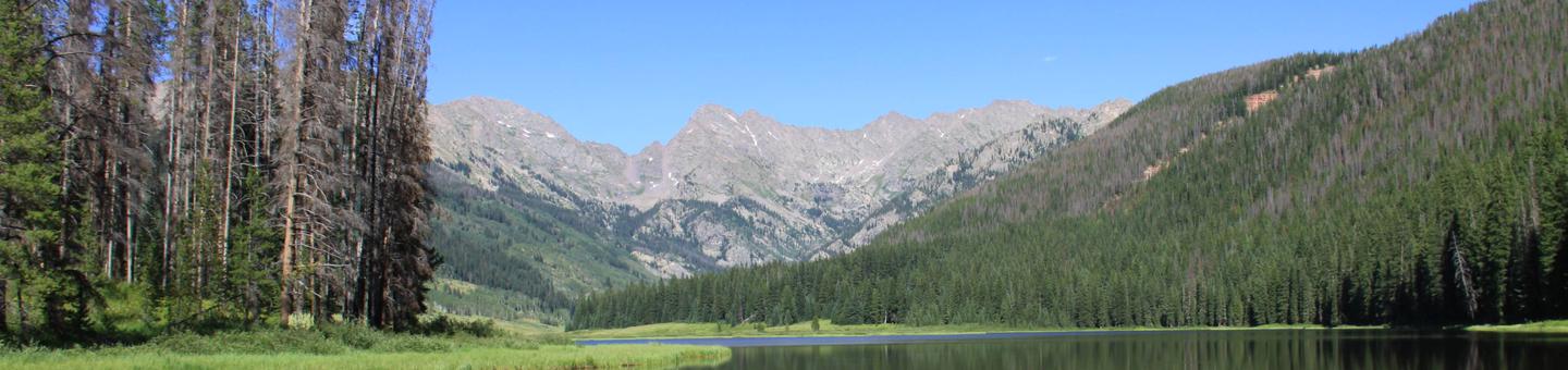
White River National Forest offers sharp contrasts of outdoor opportunities including highly developed year-round recreation near resorts as well as acces to primitive backcountry including eight designated Wilderness areas. Search for opportunities by activity, or area, and explore the outdoors at White River National Forest.
View Recreation Quicksheets that are handed out at our district offices.
RecAreaDirections
Open with Google Map
Misc
| Stay Limit | |
| Reservable | false |
| Keywords | |
| Map Link | |
| Contact Phone | |
| Contact Email |
Permits info
Facilities
White River National Forest Christmas Tree Permit Tree Permit
Little Mattie Campground Campground
List of CampsitesOverview
Located approximately 14 miles eat of Basalt, CO, in the White River National Forest, Little Mattie Campground is situated on the Ruedi Reservoir at an elevation of 7800 feet. Sites are open to the starry nighttime skies and access to the lake and trails. It sits amid a mixed conifer forest and offers an ideal setting for guest seeking recreation and relaxation.
Little Mattie has 19 standard sites suitable for tents, trailers and RVs. There is a maximum length of 30 feet for RVs & trailers. The sites are equipped with picnic tables, campfire rings and bear boxes (food storage lockers). Guests also have access to vault toilets and drinking water, but electrical hook-ups are not available.
Recreation
Renown for its fly fishing, Frying pan River flows below Ruedi Dam. Here, large rainbow, brown, cutthroat and brook trout are plentiful in an area nicknamed the “toilet bowl.” The fish feed on Mysis shrimp, a small freshwater shrimp stocked in the lake. The stretch of rive from below the dam down to the confluence of Frying Pan and the Roaring Fork River has been designated as Gold Medal Waters by the Colorado Wildlife Commission. Special regulations in this area include fishing only with artificial flies and lures, and releasing all trout except brown trout, with a limit of two fish over 14 inches. For hikers and bikers, the Ruedi Trail, located north of the reservoir, climbs to the top of Red Mountain. The trailhead is located 200 feet north of the Jeep trail near the boat ramp and parking lot. This eight mile trail gains over 3,000 feet in elevation, leading hikers to a spectacular panoramic view of the area. Boating, swimming, and water skiing are all possible. Interpretive programs are popular activities.
Facilities
Charges & Cancellations
Once your reservation start date has begun, neither the Recreation.gov Contact Center nor the campground manager will be able to modify your reservation.
Blue River Campground (CO) Campground
List of CampsitesOverview
Blue River Campground is located 10 minutes north of Silverthorne on Highway 9 in White River National Forest. This cozy campground is located between Lake Dillon and Green Mountain Reservoirs along the banks of the Blue River. With breath taking scenery and the sound of the flowing river, this is a favorite spot for many.
Recreation
Encompassing a landscape of rivers, mountains, trails and forest roads, the White River National Forest is one of the top recreation forests in the nation. Anglers will find populations of rainbow and brown trout when casting their lines out into the water. River access through the campground is for paid campers only. Boating, kayaking, paddleboarding and endless miles of hiking trails are within a short drive in either direction from the campground.
Facilities
Blue River Campground has 24 standard sites suitable for tents and smaller trailers. Vault toilets are provided. Each site has a picnic table, fire ring and bear box.
Natural Features
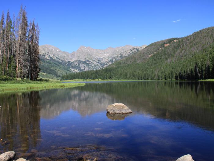
In the heart of the Rocky Mountains, the 2.3 million-acre White River National Forest is a place of serenity and adventure, boasting eight wilderness areas, four defined seasons and ten peaks surpassing 14,000 feet in elevation. The White River National Forest was established in 1891 as the White River Plateau Timber Reserve; the second such reserve to be named in the United States. In 1905, the newly formed Forest Service was given authority of the reserve. Long before this designation, the area was home to the Ute Indians who followed herds of elk and bison on their seasonal migrations. Wildlife in the area abounds. Bighorn sheep navigate rocky ridges and bull elk bugle at dusk. Scenic rivers sustain populations of cutthroat, rainbow and brown trout. Alpine regions provide habitat for pika and ptarmigan.
contact_info
For facility specific information, please call (970) 468-7681.Charges & Cancellations
Once your reservation start date has begun, neither the Recreation.gov Contact Center nor the campground manager will be able to modify your reservation.
Cow Creek North (CO) Campground
List of CampsitesOverview
Cow Creek North Campground is on the northeast shores of Green Mountain Reservoir in White River National Forest, offering an ideal setting for visitors seeking a multitude of recreational activities both on water and land.
All motorized watercraft must be inspected for Aquatic Nuisance Species and must launch from a monitored launch ramp. The Heeney Marina below the Town of Heeney on the west shore is open during daylight hours throughout the season.
Recreation
Encompassing a landscape of rivers, mountains, trails and forest roads, the White River National Forest is one of the top recreation forests in the nation. Located on the shores of Green Mountain reservoir, Cow Creek Campground is a popular spot for boating, canoeing, fishing, water skiing and windsurfing. Anglers will find populations of rainbow and brown trout, as well as kokanee salmon when casting their lines out into the water. Spring Creek is a popular off-roading area located at the northern end of the Gore Mountain Range. A network of roads open to off-road vehicle use meanders through lodgepole pine and spruce/fir forests. Viewpoints of surrounding mountains open up along these roads.
Facilities
Cow Creek North Campground has 5 group sites suitable for tents, trailers and RVs. Vault toilets are provided. The landscape around the lake is open with very few trees and miles of mountain views. Each group site has 2 picnic tables and a fire ring.
Natural Features
In the heart of the Rocky Mountains, the 2.3 million-acre White River National Forest is a place of serenity and adventure, boasting eight wilderness areas, four defined seasons and ten peaks surpassing 14,000 feet in elevation. The White River National Forest was established in 1891 as the White River Plateau Timber Reserve; the second such reserve to be named in the United States. In 1905, the newly formed Forest Service was given authority of the reserve. Long before this designation, the area was home to the Ute Indians who followed herds of elk and bison on their seasonal migrations. Wildlife in the area abounds. Bighorn sheep navigate rocky ridges and bull elk bugle at dusk. Scenic rivers sustain populations of cutthroat, rainbow and brown trout. Alpine regions provide habitat for pika and ptarmigan.
Nearby Attractions
Take some time to visit Rocky Mountain National Park to learn about the diverse landscape and history of the area through interpretive programs and exhibits. In the summer visitors may want to traverse Trail Ridge Road from one side of the park to the other, reaching alpine vistas boasting elevations of more than 12,000 feet.
Charges & Cancellations
Once your reservation start date has begun, neither the Recreation.gov Contact Center nor the campground manager will be able to modify your reservation.
Elliott Creek Campground (CO) Campground
List of CampsitesOverview
Elliott Creek Campground is located on the northwest side of Green Mountain Reservoir in White River National Forest. Sitting to the south of the dam offers an ideal setting for visitors seeking a multitude of recreational activities both on water and on land.
Recreation
Encompassing a landscape of rivers, mountains, trails and forest roads, the White River National Forest is one of the top recreation forests in the nation. Located on the shores of Green Mountain reservoir, Cow Creek Campground is a popular spot for boating, kayaking, fishing, water skiing and windsurfing. Anglers will find populations of rainbow and brown trout, as well as kokanee salmon when casting their lines out into the water. Spring Creek is a popular off-roading area located at the northern end of the Gore Mountain Range. A network of roads open to off-road vehicle use meanders through lodgepole pine and spruce/fir forests. Viewpoints of surrounding mountains open up along these roads.
Facilities
Elliott Creek Campground has 20 standard sites suitable for tents and smaller trailers. Vault toilets are provided. All motorized watercraft must be inspected for Aquatic Nuisance Species and must launch from a monitored launch ramp. The Heeney Marina below the Town of Heeney on the west shore is open during daylight hours throughout the season.
Natural Features
In the heart of the Rocky Mountains, the 2.3 million-acre White River National Forest is a place of serenity and adventure, boasting eight wilderness areas, four defined seasons and ten peaks surpassing 14,000 feet in elevation. The White River National Forest was established in 1891 as the White River Plateau Timber Reserve; the second such reserve to be named in the United States. In 1905, the newly formed Forest Service was given authority of the reserve. Long before this designation, the area was home to the Ute Indians who followed herds of elk and bison on their seasonal migrations. Wildlife in the area abounds. Bighorn sheep navigate rocky ridges and bull elk bugle at dusk. Scenic rivers sustain populations of cutthroat, rainbow and brown trout. Alpine regions provide habitat for pika and ptarmigan.
Nearby Attractions
Take some time to visit Rocky Mountain National Park to learn about the diverse landscape and history of the area through interpretive programs and exhibits. In the summer visitors may want to traverse Trail Ridge Road from one side of the park to the other, reaching alpine vistas boasting elevations of more than 12,000 feet.
Charges & Cancellations
Once your reservation start date has begun, neither the Recreation.gov Contact Center nor the campground manager will be able to modify your reservation.
Willows Campground (CO) Campground
List of CampsitesOverview
Willows Campground is located on the north shore of Green Mountain Reservoir in White River National Forest, offering an ideal setting for visitors seeking a multitude of recreational activities both on water and on land.
Recreation
Encompassing a landscape of rivers, mountains, trails and forest roads, the White River National Forest is one of the top recreation forests in the nation. Located on the shores of Green Mountain reservoir, Cow Creek Campground is a popular spot for boating, kayaking, fishing, water skiing and windsurfing. Anglers will find populations of rainbow and brown trout, as well as kokanee salmon when casting their lines out into the water. Spring Creek is a popular off-roading area located at the northern end of the Gore Mountain Range. A network of roads open to off-road vehicle use meanders through lodgepole pine and spruce/fir forests. Viewpoints of surrounding mountains open up along these roads.
Facilities
Willows Campground has 21 standard sites suitable for tents, trailers and RVs. Vault toilets are provided. All motorized watercraft must be inspected for Aquatic Nuisance Species and must launch from a monitored launch ramp. The Heeney Marina below the Town of Heeney on the west shore is open during daylight hours throughout the season.
Natural Features
In the heart of the Rocky Mountains, the 2.3 million-acre White River National Forest is a place of serenity and adventure, boasting eight wilderness areas, four defined seasons and ten peaks surpassing 14,000 feet in elevation. The White River National Forest was established in 1891 as the White River Plateau Timber Reserve; the second such reserve to be named in the United States. In 1905, the newly formed Forest Service was given authority of the reserve. Long before this designation, the area was home to the Ute Indians who followed herds of elk and bison on their seasonal migrations. Wildlife in the area abounds. Bighorn sheep navigate rocky ridges and bull elk bugle at dusk. Scenic rivers sustain populations of cutthroat, rainbow and brown trout. Alpine regions provide habitat for pika and ptarmigan.
Nearby Attractions
Take some time to visit Rocky Mountain National Park to learn about the diverse landscape and history of the area through interpretive programs and exhibits. In the summer visitors may want to traverse Trail Ridge Road from one side of the park to the other, reaching alpine vistas boasting elevations of more than 12,000 feet.
Charges & Cancellations
Once your reservation start date has begun, neither the Recreation.gov Contact Center nor the campground manager will be able to modify your reservation.
Prairie Point Campground (CO) Campground
List of CampsitesOverview
Prairie Point Campground is located north of Silverthorne, near the upper end of Green Mountain Reservoir along its east side. The reservoir is located 15 miles north of Silverthorne along Hwy 9 and has views of the Williams Fork and Gore mountain ranges.
Recreation
In addition to boating, there are a variety of activities including camping, fishing, picnicking, jet skiing, water skiing, swimming and hiking.
Facilities
There are 2 loops with vault toilets. Each site has a picnic table and fire ring with most having parking spaces in front of the walk-in site. A few parking spaces are long enough to accommodate small trailers.
Natural Features
In the heart of the Rocky Mountains, the 2.3-million-acre White River National Forest is a place of serenity and adventure, boasting eight wilderness areas, four defined seasons and ten peaks surpassing 14,000 feet in elevation. The White River National Forest was established in 1891 as the White River Plateau Timber Reserve; the second such reserve to be named in the United States. In 1905, the newly formed Forest Service was given authority of the reserve. Long before this designation, the area was home to the Ute Indians who followed herds of elk and bison on their seasonal migrations. Wildlife in the area abounds. Bighorn sheep navigate rocky ridges and bull elk bugle at dusk. Scenic rivers sustain populations of cutthroat, rainbow and brown trout. Alpine regions provide habitat for pika and ptarmigan.
Charges & Cancellations
Once your reservation start date has begun, neither the Recreation.gov Contact Center nor the campground manager will be able to modify your reservation.
DIFFICULT CAMPGROUND Campground
List of CampsitesOverview
Located 5 miles southeast of Aspen, Colorado, Difficult Campground sits on the banks of the Roaring Fork River on the western slope of the Colorado Rockies.Campsites are nestled in a mixed forest of aspen, cottonwood, pine, fir, scrub oak, and spruce, and several are at the river's edge, offering an ideal setting for guests seeking recreation and relaxation.
Recreation
Renowned for its fly fishing, the Roaring Fork River sustains populations of large rainbow, brown, cutthroat and brook trout. The nearby peaks and soothing sounds from the river offer anglers a perfect backdrop for an afternoon of fishing.Whitewater adventure seekers may want to raft portions of the Roaring Fork, as it is navigable by small craft throughout most of its length to its confluence with the Colorado.
Hikers can access trails near the campground.
Facilities
Difficult Campground has 47 standard sites, including a group site.It is important to note that vehicles over 35 feet in length are prohibited over Independence Pass but can access the campground via Aspen.
The campground is equipped with picnic tables, campfire rings, vault toilets, and drinking water. Electrical hook-ups are not available. Firewood is available for sale at the site.
Campground radius turns are tight for large RVs, and brush encroaches on roadways and spurs.
Natural Features
In the heart of the Rocky Mountains, the 2.3 million acre White River National Forest is a place of serenity and adventure, boasting 8 wilderness areas, 4 defined seasons, and 10 peaks surpassing 14,000 feet in elevation.Wildlife in the area abounds. Bighorn sheep navigate rocky ridges and bull elk bugle at dusk. Scenic rivers sustain populations of cutthroat, rainbow, and brown trout. Alpine regions provide habitat for pika and ptarmigan. These species, along with many others, depend on surrounding undeveloped wilderness, clean streams, and diverse forests to live.
The Roaring Fork River flows by the campground, a tributary of the mighty Colorado. Deep, swift and clear, the Roaring Fork rises in the Sawatch Range on the west side of the Continental Divide and drains an area of the Colorado Western Slope called the Roaring Fork Valley.
Nearby Attractions
The nearby town of Aspen is a popular destination for visitors to the area. From downhill skiing and world-class fly fishing, to dining and resorts, there is a multitude of outdoor and indoor opportunites in this mountain town.Charges & Cancellations
Once your reservation start date has begun, neither the Recreation.gov Contact Center nor the campground manager will be able to modify your reservation.
SILVER BAR Campground
List of CampsitesOverview
Silver Bar Campground is located approximately five miles southwest of Aspen, Colorado, on the banks of Maroon Creek. The campground is adjacent to the Maroon Bells Welcome Station. This small, primitive, campground features four tent-only, walk-in sites with centralized vault toilets only a few yards away from each campsite. A single accessible campsite is located near the toilets and water source.The campground sits at an elevation of 8,460 feet, allowing guests to experience warm summer days and cool evenings with probable afternoon thunderstorms. Properly licensed anglers may fish in Maroon Creek, which runs along the eastern edge of the campground. Come prepared for changing weather conditions. Snow is possible even at the peak of summer.
Recreation
For hikers and backpackers, the Maroon Bells-Snowmass Wilderness Area epitomizes the Rocky Mountains of Colorado. Starting from the Deadly Bells Trailhead at Maroon Lake, the West Maroon Trail gains elevation through aspen groves and evergreens, traverses boulder fields, crosses streams, and leads hikers through high-elevation (10,000+ feet) mountain passes. Climbing through alpine terrain, backpackers will find high mountain lakes and a smattering of wildflowers in mid-summer. Check specific regulations for camping in the Maroon Bells-Snowmass Wilderness Area.For day hikers and horseback riders, nearby Maroon Creek Trail offers a less crowded alternative to viewing the Maroon Bells, Pyramid Peak and the entire Maroon valley. The gentle, flat terrain offers scenic stops that are great for picnicking.
Facilities
Silver Bar Campground has four walk-in, tent-only sites. RVs and trailers are welcome at the standard sites. Sites are equipped with picnic tables, vault toilets, food storage lockers (bear boxes) and campfire rings. Drinking water and electrical hook-ups are not available.
Natural Features
The Maroon Bells Scenic Area is surrounded by the Maroon Bells-Snowmass Wilderness. This wilderness is one of the five original Colorado wilderness areas designated by the 1964 Wilderness Act. Its scenic value exudes from its aspen groves, meadows of wildflowers, and dark forests of spruce and fir that rise up from the valleys to alpine landscapes. Here, bighorn sheep, pika, and ptarmigan find habitat above timberline.Towering over glacial valleys at over 14,000 feet in elevation, the Maroon Bells are the most recognizable peaks in the Elk Mountains. The Maroon Bells are unique in the Rockies in that they are made up of metamorphic sedimentary mudstone that gives the peaks their maroon color and unstable nature for climbing.
Nearby Attractions
The nearby mountain resort town of Aspen is a popular destination for visitors to the area. From downhill skiing and world-class fly fishing, to dining and resorts, there is a multitude of outdoor and indoor opportunities in this mountain town.SILVER BELL Campground
List of CampsitesOverview
Located just outside Aspen, Colorado, Silver Bell Campground is hemmed in by aspen groves and subalpine forests on the banks of Maroon Creek.The campground sits at an elevation of 8,460 feet, allowing guests to experience warm summer days and cool evenings with probable afternoon thunderstorms. Come prepared for changing weather conditions. Snow is possible even at the peak of summer.
Recreation
For hikers and backpackers, the Maroon Bells-Snowmass Wilderness Area epitomizes the Rocky Mountains of Colorado. Starting from the Deadly Bells Trailhead at Maroon Lake, the West Maroon Trail gains elevation through aspen groves and evergreens, traverses boulder fields, crosses streams, and leads hikers through high-elevation (10,000+ feet) mountain passes. Climbing through alpine terrain, backpackers will find high mountain lakes and a smattering of wildflowers in mid-summer. Check specific regulations for camping in the Maroon Bells-Snowmass Wilderness Area.For day hikers and horseback riders, nearby Maroon Creek Trail offers a less crowded alternative to viewing the Maroon Bells, Pyramid Peak and the entire Maroon valley. The gentle, flat terrain offers scenic stops that are great for picnicking.
Facilities
Silver Bell Campground has 14 sites, including tent-only and walk-in sites. RVs and trailers are welcome at the standard sites. Sites are equipped with picnic tables, vault toilets, food storage lockers (bear boxes) and campfire rings. Drinking water and electrical hook-ups are not available.
Silver Bell campsites 2-4 and 8-14 are not available for advanced reservation on Recreation.gov and are set aside as first-come, first-served for up to the five day stay limit. Please visit the welcome station on Maroon Creek Road during staffed hours 7 a.m. to 7 p.m. on the day of arrival to check availability. The campground is usually full before noon during peak Summer/Fall season.
Natural Features
The Maroon Bells Scenic Area is surrounded by the Maroon Bells-Snowmass Wilderness. This wilderness is one of the five original Colorado wilderness areas designated by the 1964 Wilderness Act. Its scenic value exudes from its aspen groves, meadows of wildflowers, and dark forests of spruce and fir that rise up from the valleys to alpine landscapes. Here, bighorn sheep, pika, and ptarmigan find habitat above timberline.Towering over glacial valleys at over 14,000 feet in elevation, the Maroon Bells are the most recognizable peaks in the Elk Mountains. The Maroon Bells are unique in the Rockies in that they are made up of metamorphic sedimentary mudstone that gives the peaks their maroon color and unstable nature for climbing.
Nearby Attractions
The nearby resort town of Aspen is a popular destination for visitors to the area. From downhill skiing and world-class fly fishing, to dining and shopping, there is a multitude of outdoor and indoor opportunities in this mountain town.SILVER QUEEN Campground
List of CampsitesOverview
Located just outside Aspen, Colorado, Silver Queen Campground is hemmed in by aspen groves, a short walk from Maroon Creek, with views of 14,018 foot Pyramid Peak.The campground sits at an elevation of 8,460 feet, allowing guests to experience warm summer days and cool evenings with probable afternoon thunderstorms. Come prepared for changing weather conditions. Snow is possible even at the peak of summer.
Recreation
For hikers and backpackers, the Maroon Bells-Snowmass Wilderness Area epitomizes the Rocky Mountains of Colorado. Starting from the Deadly Bells Trailhead at Maroon Lake, the West Maroon Trail gains elevation through aspen groves and evergreens, traverses boulder fields, crosses streams, and leads hikers through high-elevation (10,000+ feet) mountain passes. Climbing through alpine terrain, backpackers will find high mountain lakes and a smattering of wildflowers in mid-summer. Check specific regulations for camping in the Maroon Bells-Snowmass Wilderness Area.For day hikers and horseback riders, nearby Maroon Creek Trail offers a less crowded alternative to viewing the Maroon Bells, Pyramid Peak and the entire Maroon valley. The gentle, flat terrain offers scenic stops that are great for picnicking.
Facilities
Silver Queen Campground has five campsites available for advanced reservation which are able to accommodate tents, trailers, and RVs. Sites are equipped with picnic tables, vault toilets, food storage lockers (bear boxes), campfire rings and drinking water. Electrical hook-ups are not available. Horses are not allowed in the campground.
Natural Features
The Maroon Bells Scenic Area is surrounded by the Maroon Bells-Snowmass Wilderness. This wilderness is one of the five original Colorado wilderness areas designated by the 1964 Wilderness Act. Its scenic value exudes from its aspen groves, meadows of wildflowers, and dark forests of spruce and fir that rise up from the valleys to alpine landscapes. Here, bighorn sheep, pika, and ptarmigan find habitat above timberline.Towering over glacial valleys at over 14,000 feet in elevation, the Maroon Bells are the most recognizable peaks in the Elk Mountains. The Maroon Bells are unique in the Rockies in that they are made up of metamorphic sedimentary mudstone that gives the peaks their maroon color and unstable nature for climbing.
Nearby Attractions
The nearby resort town of Aspen is a popular destination for visitors to the area. From downhill skiing and world-class fly fishing, to dining and resorts, there is a multitude of outdoor and indoor opportunities in this mountain town.BOGAN FLATS CAMPGROUND GRP S Campground
List of CampsitesOverview
Bogan Flats Campground stretches along the Crystal River in a valley of aspen groves, towering Ponderosa Pine, spruce, and willow. The setting is ideal for larger groups seeking recreation and relaxation in White River National Forest.Sites in the campground are widely spaced and offer a nice mixture of open and shaded spots, with several sites at the river's edge. The group site is located away from the main campground, offering a more private location.
Recreation
Crystal River, a tributary of Roaring Fork River, is renowned for its fly fishing. Rainbow, cutthroat and brown trout are plentiful in this waterway.A hike up Mt. Sopris offers spectacular panoramic views. This 12,953-foot mountain dominates the surrounding landscape. The hike is 14.8 miles with a 4,600-foot. elevation gain. In summer, wildflowers carpet the trail through aspen groves and mixed conifer forest, climbing up to talus slopes.
Other popular activities in the area include jeep tours, biking, and historic sightseeing.
Facilities
Bogan Flats Campground is able to accommodate tents, trailers and RVs, and has a designated group site.The campground is equipped with picnic tables, campfire rings, vault toilets, and drinking water. Electrical hook-ups are not available.
Firewood is available on-site for a fee.
Natural Features
In the heart of the Rocky Mountains, the 2.3 million acre White River National Forest is a place of serenity and adventure, boasting 8 wilderness areas, 4 defined seasons, and 10 peaks surpassing 14,000 feet in elevation.The Crystal River flows near the campground and drains the Valley of the Coal Miners, a glacial valley that was once a center of coal mining in southwestern Colorado.
Wildlife in the area abounds. Bighorn sheep navigate rocky ridges and bull elk bugle at dusk. Scenic rivers sustain populations of cutthroat, rainbow, and brown trout. Alpine regions provide habitat for pika and ptarmigan. These species, along with many others, depend on surrounding undeveloped wilderness, clean streams, and diverse forests to live.
Nearby Attractions
The quaint mountain town of Redstone is a hidden gem, located south of Carbondale. In addition to shops, galleries, and restaurants, the town boasts a castle that was built by industrialist John Osgood at the turn of the 20th century.Charges & Cancellations
Once your reservation start date has begun, neither the Recreation.gov Contact Center nor the campground manager will be able to modify your reservation.
CHAPMAN CAMPGROUND AND GROUP Campground
List of CampsitesOverview
Situated above the Ruedi Reservoir, Chapman Campground sits at the base of a wide valley adjacent to the Fryingpan River in White River National Forest.Sites are surrounded by lodgepole pine, and several are at the river's edge, offering an ideal setting for visitors seeking recreation and relaxation.
Recreation
Flowing through this campground is Fryingpan River, renowned for its fly fishing. Downriver, below the campground and Ruedi Dam, large rainbow, brown, cutthroat and brook trout are plentiful in an area nicknamed the "toilet bowl." Here, the fish feed on mysis shrimp, a small freshwater shrimp stocked in the lake.The stretch of river from the dam down to the confluence of Fryingpan and the Roaring Fork River has been designated as Gold Medal Waters by the Colorado Wildlife Commission. Special regulations in this area include fishing only with artificial flies and lures, and releasing all trout except brown trout, with a limit of 2 fish over 14 inches.
Chapman Reservoir is also an option for anglers wanting to cast lines in at its shore. Motorized watercraft is prohibited on Chapman Reservoir.
A horseshoe pit and volleyball court encourage game playing. A nature trail can be accessed from the site.
Facilities
Chapman Campground has 84 standard sites suitable for tents, trailers, and RVs. A group site is also available.The campground is equipped with picnic tables, campfire rings, vault toilets, and drinking water. Electrical hook-ups are not available.
Trash and recycling collection is provided.
Natural Features
In the heart of the Rocky Mountains, the 2.3 million acre White River National Forest is a place of serenity and adventure, boasting 8 wilderness areas, 4 defined seasons, and 10 peaks surpassing 14,000 feet in elevation.Wildlife in the area abounds. Bighorn sheep navigate rocky ridges and bull elk bugle at dusk. Scenic rivers sustain populations of cutthroat, rainbow, and brown trout. Alpine regions provide habitat for pika and ptarmigan. These species, along with many others, depend on surrounding undeveloped wilderness, clean streams, and diverse forests to live.
Charges & Cancellations
Once your reservation start date has begun, neither the Recreation.gov Contact Center nor the campground manager will be able to modify your reservation.
MOLLIE B_WHITE RIVER Campground
List of CampsitesOverview
Located approximately 14 miles east of Basalt, Colorado in White River National Forest, Mollie B White River Campground sits adjacent to the Ruedi Reservoir at an elevation just under 7,800 feet.Sites at this campground open up to views of the reservoir and starry nighttime skies. A mixed conifer forest hems in the shoreline, and nearby peaks offer an ideal setting for guests seeking recreation and relaxation.
Recreation
Renowned for its fly fishing, Fryingpan River flows below Ruedi Dam. Here, large rainbow, brown, cutthroat and brook trout are plentiful in an area nicknamed the "toilet bowl." The fish feed on mysis shrimp, a small freshwater shrimp stocked in the lake.The stretch of river from the dam down to the confluence of Fryingpan and the Roaring Fork River has been designated as Gold Medal Waters by the Colorado Wildlife Commission. Special regulations in this area include fishing only with artificial flies and lures, and releasing all trout except brown trout, with a limit of 2 fish over 14 inches.
For hikers and bikers, the Ruedi Trail, located north of the reservoir, climbs to the top of Red Table Mountain. The trailhead is located 200 feet north of the Jeep trail near the boat ramp and parking lot. This 8-mile trail gains over 3,000 feet in elevation, leading hikers to a spectacular panoramic view of the area.
Boating, swimming, and water skiing are all possible. Interpretive programs are popular activities.
Facilities
Mollie B Campground has 27 standard sites suitable for tents, trailers, and RVs. There is a maximum length of 40 feet for RVs. A dump station is available.The sites are equipped with picnic tables and campfire rings. Guests also have access to flush toilets and drinking water, but electrical hook-ups are not available.
A boat ramp is available for use at this campground.
Natural Features
In the heart of the Rocky Mountains, the 2.3 million acre White River National Forest is a place of serenity and adventure, boasting 8 wilderness areas, 4 defined seasons, and 10 peaks surpassing 14,000 feet in elevation.Wildlife in the area abounds. Bighorn sheep navigate rocky ridges and bull elk bugle at dusk. Scenic rivers sustain populations of cutthroat, rainbow, and brown trout. Alpine regions provide habitat for pika and ptarmigan. These species, along with many others, depend on surrounding undeveloped wilderness, clean streams, and diverse forests to live.
Nearby Attractions
The nearby town of Aspen is a popular destination for visitors to the area. From downhill skiing and world-class fly fishing, to dining and resorts, there are a multitude of outdoor and indoor opportunites in this resort mountain town.Charges & Cancellations
Once your reservation start date has begun, neither the Recreation.gov Contact Center nor the campground manager will be able to modify your reservation.
HEATON BAY Campground
List of CampsitesOverview
Heaton Bay Campground is situated at an elevation of 9,000 feet and centrally located for recreation and relaxation in the White River National Forest.There is little or no shade in the campground due to pine beetle infestation and the removal of hazard trees, but the sites offer open views to Dillon Reservoir and several mountain ranges.
Recreation
Dillon Reservoir is 3,233 acres with 26.8 miles of shoreline, offering an ideal spot for fishing, boating, and sailing. The reservoir supports a healthy population of rainbow and brown trout, in addition to a few cutthroat finding their way into the lake from feeder streams.Opportunities for hiking and biking in this area include more than 7 paved miles of the 50-mile Summit County trail system.
The Old Dillon Reservoir Trail is a favorite. This short, easy trail has spectacular views of the Tenmile Range and the Continental Divide.
For those wanting a bit more solitude, hiking in the Ptarmigan Wilderness area is a wonderful escape from the crowds.
Facilities
Heaton Bay Campground has 87 sites, able to accommodate tents, trailers and RVs. Walk-in only tent sites available of a first-come, first-served basis.The campground is equipped with picnic tables, campfire rings, vault toilets, and drinking water. Guests can fill their RV tanks. Electrical hook-ups are available for a fee at several of the sites.
Firewood is for sale from hosts at the campground.
Boat ramp access is available in the marinas located in the nearby towns of Frisco and Dillon.
Natural Features
In the heart of the Rocky Mountains, the 2.3 million acre White River National Forest is a place of serenity and adventure, boasting 8 wilderness areas, 4 defined seasons, and 10 peaks surpassing 14,000 feet in elevation.Wildlife in the area abounds. Bighorn sheep navigate rocky ridges and bull elk bugle at dusk. Scenic rivers sustain populations of cutthroat, rainbow, and brown trout. Alpine regions provide habitat for pika and ptarmigan. These species, along with many others, depend on surrounding undeveloped wilderness, clean streams, and diverse forests to live.
Nearby Attractions
Arapahoe Basin, Keystone, Breckenridge, and Copper Mountain ski resorts are all located within 10 miles from Dillon Reservoir. These resorts stay open year round.Charges & Cancellations
Once your reservation start date has begun, neither the Recreation.gov Contact Center nor the campground manager will be able to modify your reservation.
PEAK ONE Campground
List of CampsitesOverview
Peak One Campground is located on the Dillon Reservoir near the town of Frisco, offering an abundance of recreational activities. The reservoir is encircled by Swan Mountain and the dramatic Gore and Tenmile Ranges. This campground is an ideal setting for guests seeking recreation and relaxation.Due to the pine beetle infestation and removal of hazard trees, there is little or no shade in the campground.
Recreation
Dillon Reservoir, often referred to as Lake Dillon, is the greatest draw to this campground. At 3,233 acres, and with 26.8 miles of shoreline, it is an ideal spot for fishing, boating, and sailing.Anglers will find that the reservoir supports a healthy population of rainbow and brown trout, with an occasional cutthroat trout finding its way into the lake from feeder streams.
Opportunities for hiking and biking in the area abound, including more than 7 paved miles of the 50-mile Summit County trail system.
The Old Dillon Reservoir trail is a favorite. This short, easy trail has spectacular views of the Tenmile Range and the Continental Divide. The Old Dillon Reservoir was built in the 1930s to supply water to the original town of Dillon, which is now covered by the new Dillon Reservoir.
Facilities
Peak One Campground has 80 sites able to accommodate tents, trailers, and RVs.The campground is equipped with picnic tables, campfire rings, flush toilets, and drinking water. Electrical hook-ups are not available.
Firewood is for sale from hosts at the campground.
Boat ramp access is available in the marinas located in the nearby towns of Frisco and Dillon.
Natural Features
In the heart of the Rocky Mountains, the 2.3 million acre White River National Forest is a place of serenity and adventure, boasting 8 wilderness areas, 4 defined seasons, and 10 peaks surpassing 14,000 feet in elevation.Described as being more vertical than horizontal, nearby Eagles Nest Wilderness Area, designated in 1976, is a playground of craggy cliffs, sheer rock faces, alpine lakes, and deep, forested valleys. Visitors will find foot travel across this pristine area challenging and often strenuous, but will be rewarded with spectacular scenery.
Wildlife in the area abounds. Bighorn sheep navigate rocky ridges and bull elk bugle at dusk. Scenic rivers sustain populations of cutthroat, rainbow, and brown trout. Alpine regions provide habitat for pika and ptarmigan. These species, along with many others, depend on surrounding undeveloped wilderness, clean streams, and diverse forests to live.
Nearby Attractions
Arapahoe Basin, Keystone, Breckenridge, and Copper Mountain ski resorts are all located within 10 miles of Dillon Reservoir. These resorts stay open year round.Charges & Cancellations
Once your reservation start date has begun, neither the Recreation.gov Contact Center nor the campground manager will be able to modify your reservation.
WINDY POINT GROUP (CO) Campground
List of CampsitesOverview
Windy Point is located near Dillon Reservoir at an elevation of 9,000 feet in the White River National Forest. The site consists of a group camp and a group picnic shelter that can accommodate up to 100 people each.With views to Dillon Reservoir and several mountain ranges, Windy Point is ideal for larger groups seeking recreation and relaxation. Due to the pine beetle infestation and removal of hazard trees, there is little or no shade at Windy Point.
Recreation
Dillon Reservoir, often referred to as Lake Dillon, is the greatest draw to Windy Point and an ideal spot for fishing, boating, and sailing. Anglers will find that the reservoir supports a healthy population of rainbow and brown trout, with an occasional cutthroat trout finding its way into the lake from feeder streams.Opportunities for hiking and biking include more than 7 paved miles of the 50-mile Summit County trail system.
From the reservoir, the Old Dillon Reservoir Trail is a favorite. This short, easy trail has spectacular views of the Tenmile Range and the Continental Divide. The Old Dillon Reservoir was built in the 1930s to supply water to the original town of Dillon, which is now covered by the new Dillon Reservoir.
Facilities
Windy Point Group Campground has two group campsites available for the use; the Lake Loop and the Forest Loop. Both loops are able to accommodate tents, trailers and RV's. Electrical hook-ups are not available. Each loop is equipped with picnic tables, campfire rings, and vault toilets and both are pet friendly. Additionally, the Lake Loop has a handicap-accessible group picnic shelter available for use. Boat ramp access is available in the marinas located in the nearby towns of Frisco and Dillion.
Natural Features
In the heart of the Rocky Mountains, the 2.3 million acre White River National Forest is a place of serenity and adventure, boasting 8 wilderness areas, 4 defined seasons, and 10 peaks surpassing 14,000 feet in elevation.Described as being more vertical than horizontal, the nearby Eagles Nest Wilderness, designated in 1976, is a playground of craggy cliffs, sheer rock faces, alpine lakes, and deep, forested valleys. Visitors will find foot travel across this pristine area challenging and often strenuous, but will be rewarded with spectacular scenery.
Wildlife in the area abounds. Bighorn sheep navigate rocky ridges and bull elk bugle at dusk. Scenic rivers sustain populations of cutthroat, rainbow, and brown trout. Alpine regions provide habitat for pika and ptarmigan. These species, along with many others, depend on surrounding undeveloped wilderness, clean streams, and diverse forests to live.
Nearby Attractions
Arapahoe Basin, Keystone, Breckenridge, and Copper Mountain ski resorts are all located within 10 miles from Dillon Reservoir. These resorts stay open year round.Charges & Cancellations
Once your reservation start date has begun, neither the Recreation.gov Contact Center nor the campground manager will be able to modify your reservation.
PROSPECTOR Campground
List of CampsitesOverview
At an elevation of 9,000 feet, Prospector Campground is in the heart of Summit County in the White River National Forest.The sites offer open views to Dillon Reservoir and several mountain ranges, an ideal setting for guests seeking recreation and relaxation.
Due to the pine beetle infestation and removal of hazard trees, there is little or no shade in the campground.
Recreation
Dillon Reservoir, often referred to as Lake Dillon, is the greatest draw to this campground. At 3,233 acres and 26.8 miles of shoreline, Dillon Reservoir is an ideal spot for fishing, boating, and sailing. The reservoir supports a healthy population of rainbow trout and brown trout. Occasionally, a few cutthroat trout make their way into the lake from feeder streams.Opportunities for hiking and biking include more than 7 paved miles of the 50-mile Summit County trail system.
From the reservoir, the Old Dillon Reservoir trail is a favorite. This short, easy trail has spectacular views of the Tenmile Range and the Continental Divide. The Old Dillon Reservoir was built in the 1930s to supply water to the original town of Dillon, which is now covered by the new Dillon Reservoir.
For those wanting a bit more solitude, hiking in the Ptarmigan Wilderness area is a wonderful escape from the crowds.
Facilities
Prospector Campground has 105 sites, able to accommodate tents, trailers, and RVs. Roads and spurs are not paved.The campground is equipped with picnic tables, campfire rings, vault toilets, and drinking water. No electrical hook-ups are available. Firewood is for sale from hosts at the campground.
Boat ramp access is available in the marinas located in the nearby towns of Frisco and Dillon.
Natural Features
In the heart of the Rocky Mountains, the 2.3 million acre White River National Forest is a place of serenity and adventure, boasting 8 wilderness areas, 4 defined seasons, and 10 peaks surpassing 14,000 feet in elevation.Wildlife in the area abounds. Bighorn sheep navigate rocky ridges and bull elk bugle at dusk. Scenic rivers sustain populations of cutthroat, rainbow, and brown trout. Alpine regions provide habitat for pika and ptarmigan. These species, along with many others, depend on surrounding undeveloped wilderness, clean streams, and diverse forests to live.
Nearby Attractions
Arapahoe Basin, Keystone, Breckenridge, and Copper Mountain ski resorts are all located within 10 miles from Dillon Reservoir. These resorts stay open year round.Charges & Cancellations
Once your reservation start date has begun, neither the Recreation.gov Contact Center nor the campground manager will be able to modify your reservation.
CAMP HALE MEMORIAL Campground
List of CampsitesOverview
Camp Hale Memorial Campground sits at an elevation of 9,200 feet, offering guests a wonderful setting for recreation and relaxation. Camp Hale is historic because the 10th Mountain Division, an unit of 15,000 men, trained here in mountaineering and skiing techniques during WWII. Some saw combat in Italy during the war.Most of the buildings have been torn down, but foundations and other "footprints" remain.
The 99th Infantry Battalion (Viking Battalion) also trained at Camp Hale. There are interpretive signs along US Rt. 24, explaining the history and accomplishments of Camp Hale.
Recreation
With the headwaters of the Eagle River nearby, anglers will find pockets of solitude, casting lines for rainbow and brown trout. The waterway was named by the local Ute Indians who thought there were as many branches of the river as there were tail feathers on an eagle.Several ponds south of the campground offer good fishing opportunities.
The Colorado Trail crosses within walking distance of Camp Hale, and gravel roads provide easy walking and bike paths within the area.
Facilities
Camp Hale Memorial Campground has 15 standard sites able to accommodate tents, trailers and RVs.The campground is equipped with picnic tables, campfire rings, and vault toilets. Drinking water and electrical hook- ups are not available at this site. Visitors must provide their own water.
The road, parking area and spurs in the campground are gravel.
Natural Features
In the heart of the Rocky Mountains, the 2.3 million acre White River National Forest is a place of serenity and adventure, boasting 8 wilderness areas, 4 defined seasons, and 10 peaks surpassing 14,000 feet in elevation.Wildlife in the area abounds. Bighorn sheep navigate rocky ridges and bull elk bugle at dusk. Scenic rivers sustain populations of cutthroat, rainbow, and brown trout. Alpine regions provide habitat for pika and ptarmigan. These species, along with many others, depend on surrounding undeveloped wilderness, clean streams, and diverse forests to live.
This campground sits among a sparse growth of young Lodgepole pine in a wide, flat, open valley.
Nearby Attractions
The resort town of Vail is a popular destination for visitors to the area, offering downhill skiing, world-class fly fishing, dining and resorts. There is a multitude of outdoor and indoor opportunites in this mountain town.Charges & Cancellations
Once your reservation start date has begun, neither the Recreation.gov Contact Center nor the campground manager will be able to modify your reservation.
REDSTONE Campground
List of CampsitesOverview
Redstone Campground is set amidst a scattering of aspen groves on a ridge above the Crystal River at 7,800 feet, creating an ideal setting for guests seeking recreation and relaxation in White River National Forest.Sites in the campground are widely spaced and offer wonderful views of red rock outcroppings and cliffs, though an understory of tall grass and a scattered forest provides plenty of privacy.
Recreation
Crystal River, a tributary of Roaring Fork River, is renowned for its fly fishing. Rainbow, brown, cutthroat and brook trout are plentiful in this waterway.A hike up Mt. Sopris offers spectacular panoramic views. This 12,953-foot mountain dominates the surrounding landscape. The hike is 14.8 miles with a 4,600-foot. elevation gain. In summer, wildflowers carpet the trail through aspen groves and mixed conifer forest, climbing up to talus slopes.
Facilities
Redstone Campground has 37 standard sites, able to accommodate tents, trailers and RVs.The campground is equipped with picnic tables, a picnic shelter, campfire rings, showers, flush toilets, and drinking water. Electrical hook-ups are available at 17 of the sites for an additional fee. Firewood is available on-site.
Playground facilities and horseshoe pits are great for family and group gatherings.
Natural Features
In the heart of the Rocky Mountains, the 2.3 million acre White River National Forest is a place of serenity and adventure, boasting 8 wilderness areas, 4 defined seasons, and 10 peaks surpassing 14,000 feet in elevation.The Crystal River flows near the campground and drains the Valley of the Coal Miners, a glacial valley that was once a center of coal mining in southwestern Colorado.
Wildlife in the area abounds. Bighorn sheep navigate rocky ridges and bull elk bugle at dusk. Scenic rivers sustain populations of cutthroat, rainbow, and brown trout. Alpine regions provide habitat for pika and ptarmigan. These species, along with many others, depend on surrounding undeveloped wilderness, clean streams, and diverse forests to live.
Nearby Attractions
The quaint mountain town of Redstone is a hidden gem located south of Carbondale. In addition to shops, galleries, and restaurants, the town boasts a castle that was built by industrialist John Osgood at the turn of the century.Charges & Cancellations
Once your reservation start date has begun, neither the Recreation.gov Contact Center nor the campground manager will be able to modify your reservation.
CAMP HALE EAST FORK GROUP Campground
List of CampsitesOverview
Located in the wide-open spaces of a lush green valley near the headwaters of the Eagle River and East Fork Eagle River, Camp Hale East Fork is the ideal spot for large group camping.The surrounding White River National Forest offers campers a recreational oasis and an exciting Wilderness experience.
Recreation
The famous Colorado Trail winds within walking distance of the campground, offering hiking, horseback riding and opportunities for wildlife viewing to guests. Several paths throughout the campground also provide easy walking and biking areas.Fishing is available in the numerous streams nearby, including both the Eagle and East Fork Eagle River, the Camp Hale Pond and several beaver ponds, with various types of trout available.
Facilities
Camp Hale East Fork can accommodate up to 200 guests, making it the perfect destination for large parties or family reunions. The group picnic area contains several tables, a large fire ring and grills.Natural Features
Nestled in the heart of the Rocky Mountains, the 2.3 million acre White River National Forest is the top recreation forest in the nation. Known as the birthplace of wilderness and home to world-renowned skiing, the White River Forest has something to offer every outdoor enthusiast.Nearby Attractions
The White River National Forest is home to several skiing and Wilderness areas, providing countless recreational opportunities for campers.Charges & Cancellations
Once your reservation start date has begun, neither the Recreation.gov Contact Center nor the campground manager will be able to modify your reservation.
NORTH FORK CAMPGROUND Campground
List of CampsitesOverview
North Fork Campground is set in a towering aspen grove on the western slope of the Colorado Rockies at an elevation of 7,800 feet. This is an ideal setting for guests seeking recreation and relaxation. Most sites are widely spaced and open up to the river valley, though a heavy understory of tall grass and wild roses provide privacy. The North Fork of the White River is across from the campground.Recreation
Flowing near the campground is the North Fork of the White River, renowned for its fly fishing. Rainbow, brown, cutthroat and brook trout are plentiful in this waterway. The nearby peaks and soothing sounds from the river offer anglers a perfect backdrop to an afternoon of fishing.The North Fork Campground is close to a number of OHV trails. Use caution when riding, as domestic cattle may be grazing in the area.
Hikers, hunters, mountain bikers and equestrians can also find recreational opportunities nearby.
Facilities
North Fork Campground has 39 standard sites able to accommodate tents, trailers and RVs.The campground is equipped with picnic tables, campfire rings, vault toilets, and drinking water. Electrical hook-ups are not available.
Firewood is available on-site.
Natural Features
In the heart of the Rocky Mountains, the 2.3 million acre White River National Forest is a place of serenity and adventure, boasting 8 wilderness areas, 4 defined seasons, and 10 peaks surpassing 14,000 feet in elevation. Wildlife in the area abounds. Bighorn sheep navigate rocky ridges and bull elk bugle at dusk. Scenic rivers sustain populations of cutthroat, rainbow, and brown trout. Alpine regions provide habitat for pika and ptarmigan. These species, along with many others, depend on surrounding undeveloped wilderness, clean streams, and diverse forests to live. The campground sits above the North Fork White River valley, surrounded by forested mountain peaks.Nearby Attractions
Whitewater adventure seekers may want to raft portions of the White River, as it is navigable by small craft throughout most of its length to its confluence with the Green River.contact_info
For facility specific information, please call (970) 230-0275.Charges & Cancellations
Once your reservation start date has begun, neither the Recreation.gov Contact Center nor the campground manager will be able to modify your reservation.
LOWRY CAMPGROUND Campground
List of CampsitesOverview
At an elevation of 9,320 feet, Lowry Campground is located between Summit Cove and Breckenridge, Colorado in the White River National Forest.This campground is in close proximity to Dillon Reservoir and a handful of trails, making it an ideal setting for guests seeking recreation and relaxation.
Due to the pine beetle infestation and removal of hazard trees, there is little or no shade in the campground.
Recreation
Dillon Reservoir, often referred to as Lake Dillon, is the greatest draw to this campground, offering 26.8 miles of shoreline. It is an ideal spot for fishing, boating, and sailing. Anglers will find that the reservoir supports a healthy population of rainbow and brown trout, with an occasional cutthroat trout finding its way into the lake from feeder streams.Opportunities for hiking and biking include more than 7 paved miles of the 50-mile Summit County trail system.
From the reservoir, the Old Dillon Reservoir trail is a favorite. This short, easy trail has spectacular views of the Tenmile Range and the Continental Divide. The Old Dillon Reservoir was built in the 1930s to supply water to the original town of Dillon, which is now covered by the new Dillon Reservoir.
Facilities
Lowry Campground has 27 sites able to accommodate tents, trailers, and RVs. Three tent-only campsites are available on a first-come, first-serve basis.Sites 2-24 have electric hookups. There is an extra fee for the electrical service at these sites.
The campground is equipped with picnic tables, campfire rings, drinking water and vault toilets.
All campsites are allowed 10 people and two vehicles only, with a maximum vehicle length of 32 feet.
Firewood is for sale from hosts at the campground. Boat ramp access is available in the marinas located in the nearby towns of Frisco and Dillon.
Natural Features
In the heart of the Rocky Mountains, the 2.3 million acre White River National Forest is a place of serenity and adventure, boasting 8 wilderness areas, 4 defined seasons, and 10 peaks surpassing 14,000 feet in elevation.Described as being more vertical than horizontal, the nearby Eagles Nest Wilderness, designated in 1976, is a playground of craggy cliffs, sheer rock faces, alpine lakes, and deep, forested valleys. Visitors will find foot travel across this pristine area challenging and often strenuous, but will be rewarded with spectacular scenery.
Wildlife in the area abounds. Bighorn sheep navigate rocky ridges and bull elk bugle at dusk. Scenic rivers sustain populations of cutthroat, rainbow, and brown trout. Alpine regions provide habitat for pika and ptarmigan. These species, along with many others, depend on surrounding undeveloped wilderness, clean streams, and diverse forests to live.
Nearby Attractions
Arapahoe Basin, Keystone, Breckenridge, and Copper Mountain ski resorts are all located within 10 miles from Dillon Reservoir. These resorts stay open year round.Charges & Cancellations
Once your reservation start date has begun, neither the Recreation.gov Contact Center nor the campground manager will be able to modify your reservation.
Maroon Bells Amphitheatre Campground
List of CampsitesOverview
Reputed to be the most photographed mountains in Colorado, the spectacular Maroon Bells dominate this setting. Hemmed in by Maroon Lake, aspen groves and evergreen forests, Maroon Bells Amphitheater is designed for interpretive talks, and is especially popular for recreational events and weddings.
The amphitheater is available for use by the general public and can be reserved for private events. The maximum number of people allowed at the amphitheater is 50. Receptions are not allowed at this location, but can be held at the East Maroon Portal Picnic site, approximately a four mile drive.
Reservations are not accepted for Fridays and Saturdays in June, July and August; Reservations are not accepted for Fridays, Saturdays and Sundays in September and October.
Recreation
There are hiking trails of varying length and difficulty. Trails next to Maroon Lake are fairly flat and wheelchair and stroller accessible. Beyond Maroon Lake, trails become steeper and rocky.For hikers and backpackers, the Maroon Bells-Snowmass Wilderness epitomizes the Rocky Mountains of Colorado. Starting from the Maroon Bells Scenic Area, the West Maroon Trail winds through aspen groves, crosses streams, and switchbacks through forests. Climbing to alpine terrain, backpackers will find high mountain lakes and a smattering of wildflowers in early summer. Check specific regulations for camping in the Maroon Bells-Snowmass Wilderness Area.
Facilities
Designed for interpretive programs, the amphitheater can be reserved by the general public for private events.
Vehicle traffic is restricted on Maroon Creek Road from 8:00 a.m. until 5:00 p.m. past the Maroon Bells Welcome Station however there is a shuttle system in place and on a reservation system. Individuals who reserve this site are issued five vehicle passes which allow travel in a motorized vehicle past this point. Parking for the amphitheater is available at the day use parking area, 200 yards from the site. Accessible parking is available 50 yards away. Accessible vault toilets are available at this site; however, drinking water and electrical outlets are not. Any guests that cannot be accomdated with the 5 vehicle passes, will have to ride the shuttle bus and reserve tickets ahead of time.
Passes will be available for pickup at the welcome station five days prior to your event. It will be your responsibility to distribute passes and coordinate transportation with your guests.
Park all vehicles in the day use parking area. No vehicles are allowed in the bus loop for any reason.
Other options for access to the site include parking at Aspen Highlands Ski Area and riding the shuttle bus. Tickets are available through reservation only at aspenchamber.org. The Maroon Bells shuttle bus is $16.00 per adult and $10.00 for seniors 65 or older and children under 6. Operating hours for the shuttle bus are 8:00 a.m. until 5:00 p.m. Dogs are permitted on the Maroon Bells Shuttle.
If the contact information you provide in your reservation is not correct and/or you do not respond, your reservation will be considered cancelled. In order for the coordinator to contact you must leave a full name, phone number, email address. and total number of people attending. Total number allowed is 50. Guests are required to remove all trash after event. A dumpster is located toward the far end of the day use parking area.
Receptions cannot be held at the amphitheater, but they may be held at the nearby East Maroon Portal Picnic site. The East Maroon Portal Picnic site is a small, developed area situated along Maroon Creek and can accommodate up to 75 people for the morning, the afternoon, or both. All food, beverages, and scented items must be properly stored until the time of the reception. A bear-proof food locker is available to store these items while not being attended. Click here to reserve the East Maroon Portal Picnic site.
Natural Features
The amphitheatre has views of the surrounding Maroon Bells-Snowmass Wilderness. This wilderness is one of the five original Colorado wilderness areas designated by the 1964 Wilderness Act. Its scenic value exudes from its aspen groves, meadows of wildflowers, and dark forests of spruce and fir that rise up from the valleys to alpine landscapes. Here, bighorn sheep, pika, and ptarmigan find habitat above timberline.Towering over glacial valleys at over 14,000 feet in elevation, the Maroon Bells are the most recognizable peaks in the Elk Mountains. The Maroon Bells are unique in the Rockies in that they are made up of metamorphic sedimentary mudstone that gives the peaks their maroon color and unstable nature for climbing.
TIGIWON COMMUNITY HOUSE Campground
List of CampsitesOverview
The historic Tigiwon Community house is a large day-use cabin, perfect for family reunions, parties or weddings.Nestled in a forested setting, this facility has an expansive view of Colorado's Gore Range.
Recreation
Encompassing a landscape of rivers, mountains, trails, and forest roads, the White River National Forest is one of the top recreation Forests in the nation. The Community House is a few miles below a trailhead which accesses the Holy Cross Wilderness Area. Several trails lead into this special place, please learn about wilderness ethics and regulations before hiking.Facilities
Tigiwon Community House is a day-use area only. Overnight camping is prohibited.The historic Tigiwon Community house is a relatively large, one room cabin. Amenities both inside and outside the cabin are Accessible. Outside, visitors will have access to four 10-foot picnic tables, two charcoal grills, a fire pit, a horseshoe pit and vault toilets. Inside amenities include four tables, bench seating around the room and a stone fireplace.
Natural Features
In the heart of the Rocky Mountains, the 2.3 million acre White River National Forest is a place of serenity and adventure, boasting eight wilderness areas and ten peaks surpassing 14,000 feet in elevation.The White River National Forest was established in 1891 as the White River Plateau Timber Reserve, the second such reserve to be named in the United States.
Nearby Attractions
Tigiwon Community House is in the heart of the Vail Valley. It is inbetween the Holy Cross and Eagles Nest Wilderness Areas which abound with hiking trails. The valley floor has mountain bike trail opportunties. The Eagle and Colorado Rivers flow through the valley and offer many floating and fishing opportunities.Charges & Cancellations
1-50 people = $85
51 -100 people = $135
101-200 people = $185
PINEY GUARD STATION Campground
List of CampsitesOverview
Piney Guard Station is a rustic cabin that was constructed in the 1930s as a work station for Forest Service crews. This 14 by 22-ft. structure has a single room and is built from logs. It is open both summer and winter with spring and late fall closures.Recreation
The cabin is conveniently located in an area offering a variety of year-round recreational activities. The Forest Service road leading to the cabin is used by mountain bikers, hikers, snowshoers, cross-country skiers and snowmobilers. This area is popular for hunting big and small game, game birds and waterfowl.Facilities
Piney Guard Station can sleep up to four people. It contains a bunk bed, two cots, storage cabinets, a table and benches, and a woodstove. Skillet, dishware and utensils are provided. A two burner stove and lantern are provided. These require 16.4-oz. propane cylinder bottles, which are not provided and are your responsibility. A picnic table and metal fire ring are just outside the cabin’s door. A vault toilet is located approximately 50 feet from the cabin. Guests can easily gather firewood around the cabin.No drinking water, electricity or trash service is available; guests must bring their own water and garbage bags to pack out trash. Guests should consider packing most items they would bring on a regular camping trip. Dogs are allowed, please pick up after them and do not leave them unattended in or around the cabin.
Natural Features
Piney Guard Station is located at 9,100 feet in the White River National Forest, Eagle/Holy Cross Ranger District, which is near Vail. The cabin is nestled in a forest dominated by aspen, spruce, pine and fir trees. Guests can enjoy views of the Gore Mountain Range from a meadow to the cabin’s north side.Local wildlife, including moose, may be spotted near the lake, which sits across the road from the cabin. The White River National Forest is also home to elk, bighorn sheep, mountain goats, mule deer, Canada lynx and black bear. Birders may see bald eagles, peregrine falcons, Barrow's golden-eye and black swifts.
SAPPHIRE POINT OVERLOOK Campground
List of CampsitesOverview
New time slots are now available for reservations with arrival starting October 13, 2022
Sapphire Point Overlook sits between Keystone and Breckenridge on Swan Mountain Road, at an elevation of 9,500 feet. The overlook offers a stunning view of Dillon Reservoir, hemmed in by the Gore and Tenmile mountain ranges.
Sapphire Point is a day-use area that can be reserved for two-hour blocks for private gatherings. It is the only designated site where wedding ceremonies are permitted to take place on the Dillon Ranger District.
Recreation
Encompassing a landscape of rivers, mountains, trails and forest roads, the White River National Forest is one of the top recreation Forests in the nation.The area surrounding Sapphire Point Overlook provides visitors with a variety of recreational opportunities.
Dillion Reservoir is the greatest draw to the area. At 3,233 acres and 26.8 miles of shoreline, the reservoir is an ideal spot for fishing, boating and sailing. Anglers will find that the reservoir supports a healthy population of rainbow and brown trout, with an occasional cutthroat trout finding its way into the lake from feeder streams.
Opportunities for hiking and biking in this area abound as well, including more than 7 paved miles of the 50-mile Summit County trail system.
The Old Dillion Reservoir trail is a favorite among visitors. This short, easy trail has spectacular views of the Tenmile Range and the Continental Divide. The Old Dillon Reservoir was built in the 1930s to supply water to the original town of Dillon, which is now covered by the new Dillon Reservoir.
Facilities
This is a non-exclusive day-use area, able to accommodate up to 35 people for small events such as wedding ceremonies. Although the site may be reserved, all visitors have access to the site.Use of portable chairs and other furniture is allowed, however, commercial services, such as delivery of rental or catering items, are prohibited unless the vendor has a valid permit from the U.S. Forest Service.
Click here for photographs and more information about wedding ceremonies at Sapphire Point Overlook.
Natural Features
In the heart of the Rocky Mountains, this overlook is part of the 2.3 million acre White River National Forest. Recognized as a place of serenity and adventure, the area boasts eight wilderness areas, four defined seasons and ten peaks surpassing 14,000 feet in elevation.Described as being more vertical than horizontal, the nearby Eagles Nest Wilderness Area, designated in 1976, is a playground of craggy cliffs, sheer rock faces, alpine lakes and deep, forested valleys.
Wildlife in the area abounds. Bighorn sheep navigate rocky ridges and bull elk bugle at dusk. Scenic rivers sustain populations of cutthroat, rainbow and brown trout. Alpine regions provide habitat for pika and ptarmigan. These species, along with many others, depend on surrounding undeveloped wilderness, clean streams and diverse forests to live.
Nearby Attractions
Arapahoe Basin, Keystone, Breckenridge and Copper Mountain ski resorts are all located within ten miles from Dillon Reservoir. These resorts stay open year-round.contact_info
For facility specific information, please call (970) 468-7681.EAST MAROON PORTAL PICNIC SITE Campground
List of CampsitesOverview
East Maroon Portal Picnic Site is situated next to Maroon Creek, offering spectacular views of towering red stone cliffs, lush wetlands and evergreen forests. The area is an excellent gathering spot for families, group gatherings and parties.The picnic area is available for use by the general public, but can be reserved for private events. This is the only site available in the Maroon Bells Scenic Area for wedding receptions.
Recreation
Nestled in the heart of the Rocky Mountains, the 2.3 million acre White River national Forest is one of the top recreation Forests in the nation.For hikers and backpackers, the Maroon Bells-Snowmass Wilderness epitomizes the Rocky Mountains of Colorado. Starting from the East Maroon Portal, the Maroon Creek Trail winds through aspen groves and across boulder fields. After about a mile the East Maroon Trail branches off the Maroon Creek Trail and enters the wilderness. Climbing to alpine terrain, backpackers will find high mountain lakes and a smattering of wildflowers in early summer. Check specific regulations for camping in the Maroon Bells-Snowmass Wilderness Area.
Facilities
This picnic area is available for use by the general public, but can be reserved for private events for a fee. The picnic site can be reserved for the morning, afternoon, or both. This is the only site available in the Maroon Bells Scenic Area for wedding receptions.
The picnic area has three large picnic tables and can accommodate up to 70 people.
Individuals who reserve this picnic site are issued five vehicle passes which allow travel in a motorized vehicle to this site. Parties reserving both the amphitheatre and picnic site for the same event will only be issued five vehicle passes total. Parking is severely limited at the Bells and public access is our first priority. We recommend renting one or more high occupany vehicles that hold 12 or more guests.
For all others not accomdated by the 5 vehicle passes, they will have to make a reservation to ride the shuttle.
Because vehicle traffic is restricted on Maroon Creek Road from 8 a.m. until 5 p.m. past the Maroon Bells Welcome Station, anyone not accomdated by the 5 vehicle passes will have to make a reservation to ride the shuttle up to the picnic site. To access the shuttle, you must make a reservation at aspenchamber.org for tickets. The cost is $16 per adult and $10 for seniors 65 or older and children under 6. Operating hours for the shuttle bus are 8am-5pm. Dogs are permitted on the Maroon Bells Shuttle. Parking for the shuttle is available at Aspen Highlands Ski Area.
Bird seed, confetti, electric music and PA systems are prohibited at the site.
Visitors are required to remove or dispose of decorations and all trash after events. All food, beverages, scented items, and trash must be properly stored or removed when not attended. A bear-proof food locker and bear-proof waste receptacles are available at the site. Vault toilets are available at this site. Running water is not available at the picnic area.
Natural Features
The Maroon Bells Scenic Area is surrounding Maroon Bells-Snowmass Wilderness. This wilderness is one of the five original Colorado wilderness areas designated by the 1964 Wilderness Act. Its scenic value exudes from its aspen groves, meadows of wildflowers, and dark forests of spruce and fir that rise up from the valleys to alpine landscapes. Here, bighorn sheep, pika, and ptarmigan find habitat above timberline.Towering over glacial valleys at over 14,000 feet in elevation, the Maroon Bells are the most recognizable peaks in the Elk Mountains. The Maroon Bells are unique in the Rockies in that they are made up of metamorphic sedimentary mudstone that gives the peaks their maroon color and unstable nature for climbing.
Nearby Attractions
The nearby town of Aspen is a popular destination for visitors to the area. From downhill skiing and world-class fly fishing, to dining and resorts, there are a multitude of outdoor and indoor opportunities in this mountain town.COW CREEK SOUTH Campground
List of CampsitesOverview
Cow Creek South Campground is located on the northeast shore of Green Mountain Reservoir in White River National Forest, offering an ideal setting for visitors seeking a multitude of recreational activities both on water and on land. fastRecreation
Encompassing a landscape of rivers, mountains, trails and forest roads, the White River National Forest is one of the top recreation forests in the nation.Located on the shores of Green Mountain reservoir, Cow Creek Campground is a popular spot for boating, canoeing, fishing, water skiing and windsurfing.
Anglers will find populations of rainbow and brown trout, as well as kokanee salmon when casting their lines out into the water.
Spring Creek is a popular off-roading area located at the northern end of the Gore Mountain Range. A network of roads open to off-road vehicle use meanders through lodgepole pine and spruce/fir forests. Viewpoints of surrounding mountains open up along these roads.
Facilities
Cow Creek South Campground has 44 standard sites suitable for tents, trailers and RVs. Vault toilets are provided.All motorized watercraft must be inspected for Aquatic Nuisance Species and must launch from a monitored launch ramp. The Heeney Marina below the Town of Heeney on the west shore is open during daylight hours throughout the season. Other ramps are available as reservoir water levels allow.
Natural Features
In the heart of the Rocky Mountains, the 2.3 million-acre White River National Forest is a place of serenity and adventure, boasting eight wilderness areas, four defined seasons and ten peaks surpassing 14,000 feet in elevation.The White River National Forest was established in 1891 as the White River Plateau Timber Reserve; the second such reserve to be named in the United States. In 1905, the newly formed Forest Service was given authority of the reserve.
Long before this designation, the area was home to the Ute Indians who followed herds of elk and bison on their seasonal migrations.
Wildlife in the area abounds. Bighorn sheep navigate rocky ridges and bull elk bugle at dusk. Scenic rivers sustain populations of cutthroat, rainbow and brown trout. Alpine regions provide habitat for pika and ptarmigan.
Nearby Attractions
Take some time to visit Rocky Mountain National Park to learn about the diverse landscape and history of the area through interpretive programs and exhibits. In the summer visitors may want to traverse Trail Ridge Road from one side of the park to the other, reaching alpine vistas boasting elevations of more than 12,000 feet.Charges & Cancellations
Once your reservation start date has begun, neither the Recreation.gov Contact Center nor the campground manager will be able to modify your reservation.
DEARHAMER CAMPGROUND Campground
List of CampsitesOverview
Located approximately 22 miles east of Basalt, Colorado, in the White River National Forest, Dearhamer Campground sits adjacent to the Fryingpan River above Ruedi Reservoir at an elevation of 7,800 feet.Recreation
Renowned for its fly fishing, Fryingpan River flows below Ruedi Dam. Here, large rainbow, brown, cutthroat and brook trout are plentiful in an area nicknamed the "toilet bowl." The fish feed on Mysis shrimp, a small freshwater shrimp stocked in the lake.The stretch of river from the dam down to the confluence of Fryingpan and the Roaring Fork River has been designated as Gold Medal Waters by the Colorado Wildlife Commission. Special regulations in this area include fishing only with artificial flies and lures, and releasing all trout except brown trout, with a limit of 2 fish over 14 inches.
For hikers and bikers, the Ruedi Trail, located north of the reservoir, climbs to the top of Red Table Mountain. The trailhead is located 200 feet north of the Jeep trail near the boat ramp and parking lot. This 8-mile trail gains over 3,000 feet in elevation, leading hikers to a spectacular panoramic view of the area.
Boating, swimming, and water skiing are all possible in the area.
Facilities
Dearhamer Campground has 13 standard sites suitable for tents, trailers, and RVs. There is a maximum length of 35 feet for RVs.The sites are equipped with picnic tables and campfire rings. Guests also have access to vault toilets and a drinking water hydrant, but electrical hook-ups are not available.
Natural Features
In the heart of the Rocky Mountains, the 2.3 million acre White River National Forest is a place of serenity and adventure, boasting 8 wilderness areas, 4 defined seasons, and 10 peaks surpassing 14,000 feet in elevation.Wildlife in the area abounds. Bighorn sheep navigate rocky ridges and bull elk bugle at dusk. Scenic rivers sustain populations of cutthroat, rainbow, and brown trout. Alpine regions provide habitat for pika and ptarmigan. These species, along with many others, depend on surrounding undeveloped wilderness, clean streams, and diverse forests to live.
Nearby Attractions
The nearby town of Aspen is a popular destination for visitors to the area. From downhill skiing and world-class fly fishing, to dining and resorts, there are a multitude of outdoor and indoor opportunities in this resort mountain town.Charges & Cancellations
Once your reservation start date has begun, neither the Recreation.gov Contact Center nor the campground manager will be able to modify your reservation.
RUEDI MARINA CAMPGROUND Campground
List of CampsitesOverview
Located approximately 14 miles east of Basalt, Colorado, in the White River National Forest, Ruedi Marina Campground is situated on Ruedi Reservoir at an elevation of 7,800 feet.Sites at this campground open up to views of the reservoir and starry nighttime skies. A mixed conifer forest hems in the shoreline and nearby peaks offer an ideal setting for guests seeking recreation and relaxation.
Recreation
Renowned for its fly fishing, Fryingpan River flows below Ruedi Dam. Here, large rainbow, brown, cutthroat and brook trout are plentiful in an area nicknamed the "toilet bowl." The fish feed on Mysis shrimp, a small freshwater shrimp stocked in the lake.The stretch of river from the dam down to the confluence of Fryingpan and the Roaring Fork River has been designated as Gold Medal Waters by the Colorado Wildlife Commission. Special regulations in this area include fishing only with artificial flies and lures, and releasing all trout except brown trout, with a limit of two fish over 14 inches.
For hikers and bikers, the Ruedi Trail, located north of the reservoir, climbs to the top of Red Table Mountain. The trailhead is located 200 feet north of the Jeep trail near the boat ramp and parking lot. This eight mile trail gains over 3,000 feet in elevation, leading hikers to a spectacular panoramic view of the area.
Boating, swimming, and water skiing are all possible. Interpretive programs are popular activities.
Facilities
Ruedi Marina Campground has eight standard sites suitable for trailers, and RVs. The sites are equipped with picnic tables and campfire rings. Guests also have access to vault toilets and drinking water, but electrical hook-ups and tent sites are not available.
Natural Features
In the heart of the Rocky Mountains, the 2.3 million acre White River National Forest is a place of serenity and adventure, boasting eight wilderness areas, four defined seasons, and 10 peaks surpassing 14,000 feet in elevation.Wildlife in the area abounds. Bighorn sheep navigate rocky ridges and bull elk bugle at dusk. Scenic rivers sustain populations of cutthroat, rainbow, and brown trout. Alpine regions provide habitat for pika and ptarmigan. These species, along with many others, depend on surrounding undeveloped wilderness, clean streams, and diverse forests to live.
Nearby Attractions
The nearby town of Aspen is a popular destination for visitors to the area. From downhill skiing and world-class fly fishing, to dining and resorts, there are a multitude of outdoor and indoor opportunities in this resort mountain town.Charges & Cancellations
Once your reservation start date has begun, neither the Recreation.gov Contact Center nor the campground manager will be able to modify your reservation.
LITTLE MAUD CAMPGROUND Campground
List of CampsitesOverview
Located approximately 14 miles east of Basalt, Colorado, in the White River National Forest, Little Maud Campground is situated on Ruedi Reservoir at an elevation of 7,800 feet.Sites at this campground open up to views of the reservoir and starry nighttime skies. A mixed conifer forest hems in the shoreline and nearby peaks offer an ideal setting for guests seeking recreation and relaxation.
Recreation
Renowned for its fly fishing, Fryingpan River flows below Ruedi Dam. Here, large rainbow, brown, cutthroat and brook trout are plentiful in an area nicknamed the "toilet bowl." The fish feed on Mysis shrimp, a small freshwater shrimp stocked in the lake.The stretch of river from the dam down to the confluence of Fryingpan and the Roaring Fork River has been designated as Gold Medal Waters by the Colorado Wildlife Commission. Special regulations in this area include fishing only with artificial flies and lures, and releasing all trout except brown trout, with a limit of two fish over 14 inches.
For hikers and bikers, the Ruedi Trail, located north of the reservoir, climbs to the top of Red Table Mountain. The trailhead is located 200 feet north of the Jeep trail near the boat ramp and parking lot. This eight mile trail gains over 3,000 feet in elevation, leading hikers to a spectacular panoramic view of the area.
Boating, swimming, and water skiing are all possible. Interpretive programs are popular activities.
Facilities
Little Maud Campground has 21 standard sites suitable for tents, trailers, and RVs. There is a maximum length of 35 feet for RVs. The sites are equipped with picnic tables and campfire rings. Guests also have access to vault toilets and drinking water, but electrical hook-ups are not available.Natural Features
In the heart of the Rocky Mountains, the 2.3 million acre White River National Forest is a place of serenity and adventure, boasting eight wilderness areas, four defined seasons, and 10 peaks surpassing 14,000 feet in elevation.Wildlife in the area abounds. Bighorn sheep navigate rocky ridges and bull elk bugle at dusk. Scenic rivers sustain populations of cutthroat, rainbow, and brown trout. Alpine regions provide habitat for pika and ptarmigan. These species, along with many others, depend on surrounding undeveloped wilderness, clean streams, and diverse forests to live.
Nearby Attractions
The nearby town of Aspen is a popular destination for visitors to the area. From downhill skiing and world-class fly fishing, to dining and resorts, there are a multitude of outdoor and indoor opportunities in this resort mountain town.Charges & Cancellations
Once your reservation start date has begun, neither the Recreation.gov Contact Center nor the campground manager will be able to modify your reservation.
GORE CREEK CAMPGROUND Campground
List of CampsitesOverview
Gore Creek Campground is situated six miles east of Vail, Colorado, at an elevation of 8,700 feet and centrally located for recreation and relaxation in the White River National Forest.Recreation
The Gore Creek campground is located along Gore Creek in a forested setting near the boundary of the Eagles Nest Wilderness. This is the closest campground to the town of Vail and there are several trailheads nearby into the Eagles Nest Wilderness; all wilderness regulations must be observed when traveling in the wilderness (foot and horse travel only). The campground is also located at the west end of the paved Vail Pass/Tenmile Canyon recreation trail open to foot traffic and bicycles.Facilities
The campground offers 16 back-in sites, eight walk-in tent sites; number 18 is a fully accessible tent site, four handicapped accessible bathrooms and bear-resistant food lockers. Parking spurs for campsites are up to 35 feet long. RVs longer than this would not fit in this campground.Natural Features
In the heart of the Rocky Mountains, the 2.3 million acre White River National Forest is a place of serenity and adventure, boasting eight wilderness areas, four defined seasons, and 10 peaks surpassing 14,000 feet in elevation.Wildlife in the area abounds. Bighorn sheep navigate rocky ridges and bull elk bugle at dusk. Black bear and mule deer are common. Scenic rivers sustain populations of cutthroat, rainbow, and brown trout. Alpine regions provide habitat for pika and ptarmigan. These species, along with many others, depend on surrounding undeveloped wilderness, clean streams, and diverse forests to live.
Nearby Attractions
The nearby town of Vail is a popular destination for visitors to the area. From downhill skiing and world-class fly fishing, to dining and resorts, there are a multitude of outdoor and indoor opportunities in this resort mountain town.Charges & Cancellations
Once your reservation start date has begun, neither the Recreation.gov Contact Center nor the campground manager will be able to modify your reservation.
SHEPHERDS RIM CAMPGROUND Campground
List of CampsitesOverview
Surrounded by mountains and nestled near the wilderness, the Shepherds Rim Campground at Trappers Lake has 15 scenic campsites. Located at 9,720 feet in elevation, visitors can locate this campground on the right side of the road as you travel south from the Trappers Lake Outlet area.Recreation
Trappers Lake is known as the Cradle of Wilderness. At approximately 302 surface acres, the lake contains a strain of native cutthroat trout and the Colorado Parks and Wildlife operates a spawn collection station at the Cabin Creek inlet during May and June.Trappers Lake lies completely within the Flat Tops Wilderness; motorized boats and wheeled carts for boat transport are prohibited.
Facilities
Shepherds Rim Campground has one tent site, and 15 standard sites suitable for tents, trailers and RVs. The sites are equipped with picnic tables and campfire rings. Guests also have access to vault toilets and drinking water, but electrical hook-ups are not available.Natural Features
In the heart of the Rocky Mountains, the 2.3 million acre White River National Forest is a place of serenity and adventure, boasting eight wilderness areas, four defined seasons, and 10 peaks surpassing 14,000 feet in elevation.Wildlife in the area abounds. Bighorn sheep navigate rocky ridges and bull elk bugle at dusk. Scenic rivers sustain populations of cutthroat, rainbow, and brown trout. Alpine regions provide habitat for pika and ptarmigan. These species, along with many others, depend on surrounding undeveloped wilderness, clean streams, and diverse forests to live.
Nearby Attractions
There is an RV dump station within the Trappers Lake complex.contact_info
For facility specific information, please call (970) 230-0275.Charges & Cancellations
Once your reservation start date has begun, neither the Recreation.gov Contact Center nor the campground manager will be able to modify your reservation.
Marvine Campground Campground
List of CampsitesOverview
Marvine Campground is set in a towering grove of mixed conifer and aspen trees on the western slope of the Colorado Rockies at an elevation of 8,200 feet. This is an ideal setting for guests seeking recreation and relaxation.Hikers, hunters, anglers and equestrians can also find recreational opportunities nearby. This is a good base for hiking and horseback riding in the Flat Tops Wilderness. Enjoy elk hunting amidst one of the largest elk herds in North America.
Recreation
This popular campground is located 36 miles east of Meeker along Marvine Creek. It offers access to a number of trails and lakes for hiking, fishing and hunting. Fishing is available in Marvine and East Marvine Creeks, and in the Flat Tops Wilderness at Marvine Lakes. Marvine Trail #1823 and East Marvine Trail #1822 both begin near the campground.Facilities
Marvine Campground has six horse campsites. The only corrals available for public use are the ones at the horse camp sites in the campground. The corrals at the Marvine Trailhead are for Outfitter and Guide use only. Additional facilities at the campground include tables, fire grates, vault toilets and hand pump drinking water. Trash service is provided. Electrical hook-ups are not available. Livestock may be watered in the stream, about 200 yards from the campground.Natural Features
In the heart of the Rocky Mountains, the 2.3 million acre White River National Forest is a place of serenity and adventure, boasting 8 wilderness areas, 4 defined seasons, and 10 peaks surpassing 14,000 feet in elevation.Wildlife in the area abounds. Bighorn sheep navigate rocky ridges, moose graze along the streams and bull elk bugle at dusk. Scenic rivers sustain populations of cutthroat, rainbow, and brown trout. Alpine regions provide habitat for pika and ptarmigan. These species, along with many others, depend on surrounding undeveloped wilderness, clean streams, and diverse forests to live.
Nearby Attractions
East Marvine Trail: The trail leads up East Marvine Creek, through the the Flat Tops Wilderness to Johnson Lake. At the summit Big Marvine Peak offers a panoramic view of the Flat Tops Wilderness and surrounding area.Marvine Trail: The Marvine Trail begins at the end of County Road 12 right outside the campground. It accesses Marvine Creek and Marvine Lakes providing great opportunity to fish.
Marvine Lake and Slide Lake: These two lakes cover 135 surface acres and offer rainbow, brook and cutthroat trout fishing.
Marvine Lakes General Forest Area: The Marvine Lakes general forest area offers access to a number of lakes and trails in the central part of the Flat Tops Wilderness Area of the White River National Forest.
Papoose Trail: Papoose Creek Trail 2248 leads up Papoose Creek past several short waterfalls, to Papoose Basin. It then climbs onto the Flat Tops Plateau where it intersects the Oyster Lake Trail 1825.
contact_info
For facility specific information, please call (970) 230-0275.Charges & Cancellations
Once your reservation start date has begun, neither the Recreation.gov Contact Center nor the campground manager will be able to modify your reservation.
Deadhorse-Long Park Loop FR#230 Facility
From the west entrance, the road follows a series of switchbacks up a south facing slope. Near the top, the road offers a nice view of the valley and the North Fork of the White River below. After approximately 2 miles, the road enters Long Park. It then splits with the west fork following Long Park Creek and ending at Trough Gulch. The north fork proceeds up Long Park Creek to the divide between the Williams Fork and White River drainages. As you follow the divide to the north, you see the Elk Head Mountains and the south fork of the Williams Fork River below. To the east and south, you see the White River Valley and the Flat Tops. The road follows the divide for approximately 3 miles, then drops back into the White River drainage. As you proceed, you find another junction. The west fork here ends at Missouri Creek and the east fork brings you to the Deadhorse end of the loop. The road descends quickly over a steep, rough and narrow road where it returns to Rio Blanco County Road 8.
Print a trail description and map
Clark Point Overlook Facility
Clark Point Overlook Trail is 0.8 miles long. It begins at Forest Trail 2158 and ends at the overlook. The trail is open for the following uses: Hiking and Horseback Riding
Georgia Pass Road (South Fork Swan) #355 Facility
This 4WD road passes the town site of Parkville, the main mining camp in Summit County during the gold rush of the 1860s. All that remains now of the once bustling town is the cemetery, which can be accessed via a short hike. From Parkville to the summit, stay on the main road because a number of the intersecting roads are dead-ends. The summit is an open, grassy saddle with spectacular views of Mt. Guyot to the west. The road continues over Georgia Pass on a gravel road into Park County and down to the Michigan Creek Campground, which is located in the South Park Ranger District of the Pike/San Isabel National Forest.
* There is a printable Recreation Quicksheet for this road which is complete with directions, a map, details, and other information about this trail. Or to see quicksheets for other recreation areas across the Forest, click on the "Recreation Quicksheets" link in the right column and select the appropriate Ranger District.
Burnt Ridge Road #651.1 Facility
Burnt Ridge Road is 7.6 miles. It is opne to vehicles with high clearance, ohv, motorcycle, horse, bicycle and foot traffic.Tthe Connects to #603 and #640.
West Divide Road #800.1 Facility
The West Divide Road is 12 miles. It is open to high clearance vehicles, ohv, motorcycle, horse, bicycle and foot traffic. The road closes Nov 23 in accordance with the travel management plan. It is open for winter use as soon as the snow is suitable.
Breckenridge Area Facility
Keystone Ski Resort Facility
http://www.keystoneresort.com/
Bench Road (Forest Road #647) Facility
Bench Road is 4.3 miles. It is open to high clearnace vehicles, ohv, motorcycles, horse and foot traffic. Bench Road completes a loop from #601. The road runs parallel just outside the Flat Tops Wilderness.
Green Mountain/Heeney Area Facility
Vail Area Facility
The eastern portion of the Eagle-Holy Cross Ranger District surrounding the towns of Vail, Avon, and Redcliff, including the east side of the Holy Cross Wilderness and the west side of the Eagles Nest Wilderness.
Copper Mountain Ski Resort Facility
http://www.coppercolorado.com/
Silverthorne Area Facility
Silverthorne Area
Frisco Nordic Center Facility
http://www.frisconordic.com/
Basalt Area Facility
Beaver Creek Ski Resort Facility
Beaver Creek Ski Resort is an alpine and cross-country ski resort that also offers summer activities of all sorts.
Holy Cross City Jeep Road #759 Facility
This extreme road starts off Homestake Road #703 and ends at Holy Cross City historic site. This is one of the more difficult and popular roads in the state. It is recommended to consult a 4-wheel drive guide book for a detailed description of this route and recommended vehilce specs. Stock vehicles should not attempt this one.
Click here to see a Recreation Quicksheet for this road, complete with directions, description, map, and more.
Maroon Bells Scenic Area Facility
Welcome to the iconic Maroon Bells area located near Aspen, CO. The Maroon Bells Scenic Area is surrounded by the Maroon Bells-Snowmass Wilderness where restrictions apply. Visit below for information to plan your day trip or Wilderness experience.
Maroon Bells Information Line: (970) 945-3319. Contact for current Maroon Bells information. (**ALERT: Maroon Creek Road/Maroon Bells 2019 opening will be delayed until May 24 due to avalanche debris.)

Bowen Lake #631.1 Facility
Bowen Lake #631.1 is open to high clearance vehicles, OHV, horse and foot traffic.
Meadow Ridge Campground Campground
List of CampsitesMeadow Ridge Campground is located 35 miles north of New Castle via the Buford-New Castle Road (County/Forest Road 245). The campground offers 20 campsites, all of which are available on a first-come, first-serve basis. These campsites are suitable for tent, RV, and trailer camping, with parking spurs of up to 50 feet in length.
Facilities at the campground include picnic tables, fire grates, trash disposal, secure food storage, and vault toilets. The campground includes several handicap accessible sites. This is a fee use area.
Meadow Ridge Campground is located less than 0.25 miles from Meadow Lake. During your stay at the campground, be sure to check out the Meadow Lake Picnic Area. The Picnic Area includes picnic tables and fire rings on both sides of the lake, plus a dock, boat ramp, and restroom on the western shoreline. The day use fee for the Picnic Area is waived for campground guests. Meadow Lake itself is located in a popular area for fishing, hunting, and OHV riding. The campground also provides an easy staging area for accessing numerous non-motorized trails in the southwest Flat Tops.
Typical open season dates are May 28 to October 25.
Trappers Lake / Scotts Bay Picnic Site Facility
The Scotts Bay Picnic Site is between the Trappers Overlook and the Cutthroat Campground. It has an amphitheatre, and is used for interpretive presentations.
No Name Road #705 Facility
This dirt road starts at Hwy 24 and ends at Hwy 24 again further to the south: This road is flat for the first 1/2 mile before steadily climbing switchbacks through forest for another 2 miles or so before reaching a ridge with outstanding views of the Homestake Valley and Camp Hale. It then climbs quickly into the forest and continues winding south for a total of 20 miles over the Continental Divide and ending up back at Hwy 24.
Click here to see a Recreation Quicksheet for this road, complete with directions, description, map, and more.
Glenwood Springs Area Facility
Glenwood Springs is a good starting point for excursions into the southeastern Flat Tops, Glenwood Canyon, and the Roaring Fork Valley. From Glenwood Springs, users can access miles of motorized and non-motorized trails, all of which lead into rugged and scenic parts of the White River National Forest. Nearby attractions include Grizzly and No Name Creek Canyons, the Transfer Trail OHV/4WD route, Mitchell Creek Trail, the Fourmile Park area, and Sunlight Mountain Resort.
The Glenwood Springs area includes trails that are open to foot, horse, bicycle, and motorized use (check travel rules on individual trails before heading out). This area features numerous creeks and lakes, many of which provide good fishing opportunities. During the winter months, this area is a great place for snowmobiling and snowshoeing. Other recreation opportunities include dispersed camping, big game hunting, and wildlife viewing.
All services, including food, gas, and lodging, are available in Glenwood Springs. Visit the Sunlight Ski Area page to learn more about alpine skiing opportunities on the neighboring Aspen-Sopris Ranger District.
Aspen Mountain Ski Area Facility
Aspen Mountain and its famous black-diamond terrain has kept the town of Aspen on the map since 1947, serving up great groomers, glades, bumps and steeps for anyone who dares step off the lift. Vertical rise: 3,267 ft./996 mTerrain: 675 acres/273 hectaresNumber of trails: 76Miles/km of trails: 64 miles/103 kmLongest run: 3 miles/4.83 kmTypes of trails: easiest: 0%, more difficult: 48%, most difficult: 26%, expert: 26%Lifts: 8: 6 primary – 1 gondola (14-minute ride), 1 high-speed quad, 1 high-speed double, 1 quad, 2 doubles; 2 secondary – 1 quad (Little Nell), 1 double (Bell Mountain)Lift hours: All lifts open at 9 a.m. and close at 3:30 p.m.Rental/Retail: Four-Mountain Sports/D&E Ski and Snowboard Shop/D&E Women across the street from the Silver Queen GondolaOn-Mountain Restaurants: 4: Sundeck, Bonnie's, Ajax Tavern, Montagna Restaurant and Bar in The Little Nell
Ripple Creek Overlook Interpretive Site Facility
Ripple Creek Overlook Interpretive Site provides a nice rest stop along the Flat Tops Trail Scenic Byway. The site provides picnic facilities and restrooms. Camping is prohibited within 1/4 mile of the Overlook.
Gold Park Campground Campground
List of Campsites**Bear activity has been increasing. For this reason a food storage order is in effect at all developed campgrounds on the Eagle/Holy Cross Ranger District, and the Piney Guard Station, Tigiwon Lodge, Mount of the Holy Cross Overlook, Homestake Road FSR 703, and Nolan Creek Road. This order requires all food and refuse to be stored in hard-sided vehicles, approved bear-resistant containers, or supended at least 10 feet clear of the ground at all points and four feet horizontally from any supporting tree or pole. This order has been issued to provide for public safety and wildlife conservation. Hopefully it will reduce wildlife habituation problems.
The Gold Park campground is located along Homestake Creek in the Homestake Valley in a forested setting. There are 12 camp sites available.
Holy Cross Wilderness is nearby; all wilderness regulations must be observed when traveling in the wilderness (foot and horse travel only). There are several trailheads into the wilderness within driving distance of the campground and the Homestake Reservoir is about 3 miles further west on Homestake Road.
There is a printable Recreation Quicksheet for this campground which is complete with directions, details, and other information about this campground.
Breckenridge Nordic Center Day Use Area Facility
http://www.breckenridgenordic.com/
Summit County Rec Path Facility
The Summit County Recreational Pathway System (Recpath) is a 55-mile long network of paved, non-motorized pathways that connect towns and resorts throughout Summit County. The Summit County system is connected to Eagle via Vail Pass.
Cliff Lakes Road #601.4E Facility
Cliff Lakes Trail is accessible from Trail #601 and is open to full sized vehicle with high clearance; ohv, bike, horse and foot traffic.The trail is .8 miles.
Eagle Area Facility
The area south of the town of Eagle and I-70, accessed primarily by Brush Creek Road. This area is part of the Eagle-Holy Cross Ranger District.
Snowmass Area Facility
Snowmass Area
SW/Central Flat Tops Area Facility
Southwest and central Flat Tops area. Access often from New Castle.
Middle Creek Road #719 (winter) Facility
This route starts at Red Sandstone Road and ends at the Eiseman Hut: The trail begins at the Forest Service road closure on Red Sandstone Road #700. It follows this road for 3 miles to the junction with Lost Lake Road #786. Turn right here and follow for 1.35 miles to Middle Creek Road on the right. Middle Creek Road meanders another 4.7 miles to the Eiseman Hut. Snowmobilers need to be aware that motorized vehicles are not allowed within 1/4 mile of any of the district’s 10th Mountain Division Huts. Due to its distance from the parking area (18.1 miles round trip) this trail receives less use towards the top and is suggested for skiers in good physical condition.
Meadow Lake Picnic Area Facility
The Meadow Lake Picnic Area provides an outstanding location for relaxed recreation in a scenic setting. Amenities include picnic tables, fire rings and vault toilets on the lake's northwest and northeast shorelines. The handicap accessible dock is currently unavailable.. The Meadow Lake and Meadow Ridge Campgrounds are both within walking distance of the Picnic Area. This is a fee use site, but fees are waived for campground guests.
Meadow Lake itself is located in the southwest Flat Tops, and is a popular destination for fishing and boating. The Picnic Area also makes for a great stop after an adventure on one of the many motorized or non-motorized trails in the vicinity.
Ripple Creek Pass Facility
Ripple Creek Pass is on the Flat Tops Trail Scenic Byway between Meeker and Yampa. Many dispersed camping sites are available along the Byway near the Ripple Creek Overlook.
This road is not plowed in the winter. The White River Snowmobile club grooms a trail on the road.
Ptarmigan Peak Wilderness Facility
The United States Congress designated the Ptarmigan Peak Wilderness (map) in 1993 and it now has a total of 12,760 acres. All of this wilderness is located in Colorado and is managed by the Forest Service.
The Ptarmigan Peak Wilderness is located north of the town of Silverthorne in the Williams Fork Mountains. The range is dominated by Ptarmigan Peak (12,458 feet) on the southern end and Ute Peak (12,297 feet) on the northern end. A typical lodgepole-pine forest rises to Engelmann spruce and subalpine fir and then on to alpine tundra at the highest elevations. The lower elevation slopes have beautiful Aspen groves and open sagebrush meadows.
You will not find many trails in this Wilderness and, as a result, have a better opportunity for solitude. Most of the trails have spectacular views of the Gore Range which dominates the skyline on the other side of the Blue River Valley. One can connect the Ptarmigan Peak trail to the Ute Peak/Pass trail for an amazing one-way alpine ridgeline hike of 12 miles.
Protect this special place for the future by always using Leave No Trace techniques and following all special Wilderness restrictions including:
Camping – Wilderness appropriate campsites are previously impacted sites, at least 100 feet from trails, lakes and streams.
Fires – Campfires need to be at least 100 feet from streams and trails. Within ¼ mile of lakes are “stove only” zones and campfires are not allowed. Please refrain from having campfires near or above tree-line, or in areas without dead and down firewood.
Human Waste and Trash – Poop and litter is piling up in popular destinations. Do your part, pack out all trash (DO NOT BURN) and consider packing out your poop to prevent sanitation issues.
Dogs – Pets are required to be on a leash to protect wildlife, other visitors experience and your privilege to have them with you.
"If future generations are to remember us with gratitude rather than contempt, we must leave them something more than the miracles of technology. We must leave them a glimpse of the world as it was in the beginning, not just after we got through with it." President Lyndon B. Johnson, on the signing of the Wilderness Act of 1964
McAllister Gulch Road #708 Facility
McAllister Gulch Road #708 begins at Camp Hale and ends at Shrine Pass Road #709. This is a rough 4WD road that requires a high-clearance 4WD vehicle. It does provide excellent views near the top of both Resolution Mountain and Hornsilver Mountain.
Click here to see a Recreation Quicksheet for this road, complete with directions, description, map, and more.
Four Mile FR#214 / Widow Springs FR#212 Facility
The Four Mile Road rises out of Miller Creek and follows Four Mile Creek through scrub oak and stands of spruce and fir. After one mile, the road levels off on a rolling plateau. The road travels through open parks, aspen stands and scattered patches of conifers for the remaining 4 miles to the junction of the Bar HL Road (FR#211). The Widow Springs Road traverses the area to the east of the Four Mile Road, and meets the Bar HL Road after 8.5 miles. At their southern ends, both roads join the Bar HL Road. It is possible to complete a loop by traveling 2 miles on the Bar HL Road.
Print a road description and map
Vail Ski Resort Facility
Vail is an alpine and cross-country ski resort that also offers summer activities of all sorts. Visit the Vail Mountain Resort online for more specific information.
Meadow Lake Campground Campground
List of CampsitesMeadow Lake Campground is located 35 miles north of New Castle via the Buford-New Castle Road (County/Forest Road 245). The campground offers 10 campsites, all of which are available on a first-come, first-serve basis. These campsites are suitable for tent camping and small trailers, with parking spurs of up to 16 feet in length.
Facilities at the campground include picnic tables, fire grates, trash disposal, secure food storage, and a vault toilet. The campground includes several handicap accessible sites. This is a fee use area.
Meadow Lake Campground is located just north of Meadow Lake. The campground is also a short distance from the Meadow Lake Picnic Area. The Picnic Area includes picnic tables, fire rings, a dock, boat launch, and restroom. The day use fee for the Picnic Area is waived for campground guests.
Meadow Lake itself is located in a popular area for fishing, hunting, and OHV riding. The campground also provides an easy staging area for accessing numerous non-motorized trails in the southwest Flat Tops.
Typical open season dates are May 28 to October 25.
Flat Tops NW Facility
Flat Tops NW covers the southeastern part of the Blanco Ranger District (including most of the Flat Tops Wilderness) from Ripple Creek Pass to Rio Blanco County Road 10.
Grizzly Jeep Road #632.1 Facility
Grizzly Jeep is open to high clearance vehicles; OHV, motorcycles, horse and foot traffic.
Lincoln Creek Dispersed Campground Campground
List of CampsitesThere are 22 dispersed campsites for car camping along Lincoln Creek Road. High Clearance required and 4x4 recommended to access all campsites. All sites are first come first serve. No facilities such as toilets or water are available. Maximum 5 day stay limit.
Keystone Area Facility
SE Flat Tops Area Facility
The SE Flat Tops Area is north of Dotsero and I-70, and is primarily accessed by Forest Service Roads heading northwest off of the Colorado River Road between Dotsero and Burns. This area is part of the Eagle-Holy Cross Ranger District.
Bison Lake Road #640.1 Facility
Bison Lake Road is 4.2 miles. It is open to high clearnace vehicles, ovh, motorcycle, horse and foot traffic. Taking 640 makes a nice loop from #601.
Breckenridge Ski Resort Facility
http://www.breckenridge.com/
Frisco Area Facility
Marble Area Facility
Old Snowmass Area Facility
Old Snowmass Area
Carbondale Area Facility
Corral Point Road #649.1 Facility
Corral Point Road is 2.4 miles. The road is open to vihicles with high clearance, ohv, motorycycle, horse, bicycle and foot traffic. The road connects#601 and #650.
El Jebel Area Facility
Eagles Nest Wilderness Facility
The United States Congress designated the Eagles Nest Wilderness (map) in 1976 and it now has a total of 133,496 acres. All of this wilderness is located in Colorado and is managed by the White River National Forest.
The rugged mountains of the Gore Range are at the heart of the Eagles Nest Wilderness and serve as a major contribution to the waters of the Colorado River. Melting snow in the spring plunges from the heights to create thundering creeks, verdant meadows and spectacular wildflowers. This is an area that is more vertical than horizontal, with jagged peaks, sharp-edged ridges, deep valleys, sparkling alpine lakes, and dense forests.
The area is known for its excellent hiking and backpacking on approximately 180 miles of trails that can be accessed from the towns of Silverthorne, Frisco and Vail, Colorado.
Many of the high alpine lakes are being heavily impacted as a result of increased visitor use. Negative impacts are occurring to the natural resources including vegetation, wildlife and water.
Protect this special place for the future by always using Leave No Trace techniques and following all special Wilderness restrictions including:
Camping - Wilderness appropriate campsites are previously impacted sites, at least 100 feet from trails, lakes and streams.
Fires - Campstoves are recommended. Fires are prohibited within l00 feet of any stream or Forest Service Trail, within ¼ mile of any lake, or at any point above treeline. Please refrain from having campfires in areas without dead and down firewood.
Human Waste and Trash - Poop and litter is piling up in popular destinations. Do your part, pack out all trash (DO NOT BURN) and consider packing out your poop to prevent sanitation issues.
Dogs - Pets are required to be on a leash to protect wildlife, other visitor’s experience and your privilege to have them with you.
"If future generations are to remember us with gratitude rather than contempt, we must leave them something more than the miracles of technology. We must leave them a glimpse of the world as it was in the beginning, not just after we got through with it." President Lyndon B. Johnson, on the signing of the Wilderness Act of 1964
Wilderness areas Facility
With the passage of the Wilderness Act in 1964, Congress created the National Wilderness Preservation System. Wilderness areas are managed to preserve their natural conditions and wild character for present and future generations. They possess outstanding ecological, geological, scientific, educational, scenic, or historic values.
Please view the special regulations associated with Wilderness and always use Leave No Trace techniques to help keep these areas wild, clean, and pristine.
There are 8 Wildernesses within White River National Forest. These areas include:
- Collegiate Peaks Wilderness
- Eagles Nest Wilderness
- Flat Tops Wilderness
- Holy Cross Wilderness
- Hunter-Frying Pan Wilderness
- Maroon Bells-Snowmass Wilderness
- Ptarmigan Peak Wilderness
- Raggeds Wilderness
Wilderness videos
Redstone Area Facility
Redstone Area
East & West Divide Creek Area Facility
Access West Divide via County Road 331 and East Divide via County Road 313. Both out of Silt
Bar HL/Hay Flat FR#211 Facility
The Bar HL/Hay Flat road provides good access to a number of OHV trails; some provide loop opportunities and some are dead ends.
This road requires a vehicle with clearance. Water bars can fill and become deep. It is not recommended for vehicles pulling long trailers, and vehicles pulling short trailers should consider road conditions. There are few places to turn around in the first few miles of the road.
The road climbs through a forested area, then opens to a meadow as it reaches Hay Flats.Vegetation includes spruce, fir, and aspen, with scrub oak at lower elevations.
Print a trail description and map
Aspen-Sopris Ranger District Facility
Aspen-Sopris manages five Wilderness areas and the spectacular Maroon Bells Recreation Area, the historical Crystal Mill, Ashcroft ghost town, and the small mining town of Marble, CO. This area provides outstanding recreational opportunities including downhill & cross-country skiing, hunting, hiking, camping, rafting, four-wheeling, snowmobiling, and world class fly fishing in gold medal waters.
Big game hunters will find numerous rewards with our generous elk and deer populations hosting an estimated 45,000 elk and 80,000 deer within our summer inventory. Our forest rangers offer hundreds of group tours and interpretive presentations throughout the year at our local schools, on the trail, in our campgrounds, and on location at our three visitor centers.
For visitors unable to visit one of our visitor center locations, please search our Recreation Opportunity Guides for free downloadable road and trail guides for the Aspen-Sopris Ranger District.
Recreation areas within this district include:
Woody Creek Area Facility
Woody Creek Area
Black Bess Picnic Site Picnic Site Facility
Black Bess Picnic Site Picnic Site
Wearyman Road #747 Facility
This rugged dirt road starts at Shrine Pass Road #709 and ends at Resolution Road #702 near the top of Ptarmigan Pass. It has several creek crossings and rocky sections requiring a high-clearance 4WD vehicle. There are panoramic views at the top of Ptarmigan Pass, where the much easier Resolution Road #702 then descends down to Camp Hale.
Click here to see a Recreation Quicksheet for this road, complete with directions, description, map, and more.
Corral Creek Road #650.1 Facility
Corral Creek Road is 2 miles. It is open to high clearance vehicles, ohv, motorcycle, horse, bicycle and foot traffic. The road connects to the Meadow Lake and Meadow Ridge Campgrounds and the Meadow Lake Fishing Day Use area.
Ruedi Marina Boat Ramp Facility
Ruedi Marina Boat Ramp is a put-in for boats into Ruedi Reservoir. The Forest Service is concerned by the serious threat posed to our aquatic habitats by two non-native and invasive aquatic mussels —the Zebra mussel and the Quagga mussel. The boating season brings with it mandatory state-certified boat inspections to help prevent the spread of zebra and quagga mussels in Colorado reservoirs.
Preventing the spread of aquatic nuisance species starts with you – the vessel owner. Boats and boat trailers can easily transport aquatic hitchhikers in many different ways. If you don’t clean your vessel, you may introduce aquatic nuisance species to other waters.
For more information on boat inspections, please click here.
Beecher Loop Facility
From Wolverton Spring ride southwest on Hardscrabble Rd. for 2.5 miles until you get to the junction of FDR 413 and FDR 451, turn left staying on FDR 413.Travel .6 miles to the switchback and turn right, travel for 6.3 miles to FDR 441, Beecher Rd., and turn left.Travel .3 miles to the first gate, pass around the gate and follow the main trail for 3.8 miles to a second gate, which you will by-pass and stay on the hard-packed road for 2.3 miles back to Hardscrabble Rd.A short distance after passing through the first gate, the predominantly downhill route becomes rough and cobbley, especially during the first couple of miles. Upon passing the second gate the road consists of a smooth downhill ride with only two climbs.Once back to Hardscrabble Rd., veer right, and head .6 miles back to the “Y” and then turn right for the last 2.5 miles back to Wolverton Spring.An abundance of wildlife, beautiful views and wildflowers make this loop enjoyable.Aspen groves and lodge pole pine provide plenty of shade either on the path or a short distance from the road.
Rio Blanco County Road 10, South Fork Road Facility
Part of Rio Blanco County Road 10 is not plowed during the winter. The White River Snowmobile Club grooms a trail on the road; the site is popular with cross-country skiiers and snowmobilers.
Buford-New Castle Road (Forest Road-245) Facility
The Buford-New Castle Road is the main thoroughfare across the Flat Tops, spanning a total length of approximately 42 miles. The route provides access to numerous side roads, dispersed camping areas, and non-motorized trails. The road is open to highway legal vehicles, along with bicycle, foot, and horse travel. The road is graveled and suitable for passenger cars, though the surface is washboarded in many places. Please drive carefully and stay on the right hand side of the road, especially when rounding blind corners.
OHVs are not allowed on the Buford-New Castle Road. Instead, OHVs should use motorized trail #2290 (also known as the BNC parallel route), which begins at the West Elk Trailhead and ends at Forest Road-601 near Meadow Lake.
Meeker Area Facility
This includes areas south and east of Meeker, outside of the Flat Tops Wilderness.
Cattle Guard Road #603.1P Facility
Cattle Guard Road is 1.9 miles and is open to high clearance vehicles, OHV, horse and foot traffice. It is a short cut back to #651.
Conundrum Hot Springs - Maroon Bells-Snowmass Wilderness Permit
Overview:
Watch this video to learn more about ''Leave No Trace'' at Conundrum Hot Springs (1:46)Conundrum Hot Springs, at 11,200 feet in elevation, are a special feature of the 181,976-acre Maroon Bells-Snowmass Wilderness. This area carries special legal designation to protect its natural, undeveloped and untrammeled qualities as well as providing outstanding opportunities for solitude or primitive and unconfined recreation.
Permit Information
Permits are required year-round for overnight camping in the vicinity of the Conundrum Hot Springs. The permit area includes all of Conundrum Creek Valley from Silver Dollar Pond to Triangle Pass. Overnight campers are required to reserve and camp in designated sites. Each designated campsite has an individual maximum number of people allowed to camp at the site (from 2-6 people). View map of designated campsites.
Overnight permits are released according to the following schedule:
- Overnight permits for April 1-July 31 are available at 8 a.m. MT on February 15th
- Overnight permits for August 1-November 30 are available at 8 a.m. MT on June 15th
- Overnight permits for December 1-March 31 are available at 8 a.m. MT on October 15th
The maximum length of stay from June 1-September 1 is three nights. There is a seven night maximum stay the rest of the year.
A person is limited to two permits in a calendar year.
Attention Pack and Saddle Stock: Conundrum Creek Trail above Silver Dollar Pond not suitable for pack and saddle stock. Overnight pack and saddle stock are not allowed at any designated campsite in the permit zone.
Conundrum Creek Trail Access
The distance to Conundrum Hot Springs from the Conundrum Creek trailhead is approximately 8.5 miles (one-way) with an elevation gain of approximately 2,500 feet. The trail crosses Conundrum Creek three times before the hot springs. Primitive log bridges span the first and the second crossings. The third crossing requires wading through the creek. This crossing can be hazardous, especially during spring runoff, and is noteworthy for trip planning.
Driving Directions to Conundrum Trailhead from Aspen
Drive a half mile west of Aspen on Highway 82 to the roundabout. Go around the roundabout and turn right onto Castle Creek Road. Drive approximately 5 miles up Castle Creek Road and turn right onto Conundrum Road. Continue 1.1 miles to a parking lot at the trailhead. Be careful not to stray onto the numerous private driveways found along the road. Trailhead parking is limited. Carpooling is highly recommended. Parking is prohibited on Conundrum Road. This narrow road is on a County right-of-way over private property. Vehicles are towed.
West Elk Stock Driveway #2152 Facility
The West Elk Stock Driveway parallels the Cherry Creek Trail as both routes descend from Forest Road 819 to the bottom of the Buford-New Castle Road. The northern half of the Stock Driveway winds through stands of spruce and aspen with a gentle grade and smooth, wide tread. This is an excellent location to view autumn aspen colors. The southern half of the trail travels through oak brush and pinyon juniper while offering good views of the surrounding foothills. This southern section is rougher, steeper, and harder to navigate in certain places; riders should traverse this area with caution, especially when grazing animals are present on the forest. The West Elk Stock Driveway ends at an intersection with the Cherry Creek trail. From here, travel another 0.4 miles south to the Buford-New Castle Road.
The West Elk Stock Driveway provides several interesting loop opportunities with the Cherry Creek and Mansfield Ditch Trails. At 0.6 miles south of FR-819, the Stock Driveway intersects with a short connector trail that leads down into the Cherry Creek drainage. Another intersection is located at 2.0 miles; from here, follow the Cherry Creek Connector (#2256.1A) 1.4 miles east to Cherry Creek. From this intersection with Cherry Creek, visitors can follow an additional connector trail 0.5 miles east to the Mansfield Ditch.
The West Elk Stock Driveway is open to mountain bikes, horses, and hikers.
View the Recreation Opportunity Guide for the West Elk Stock Driveway (.pdf).
