
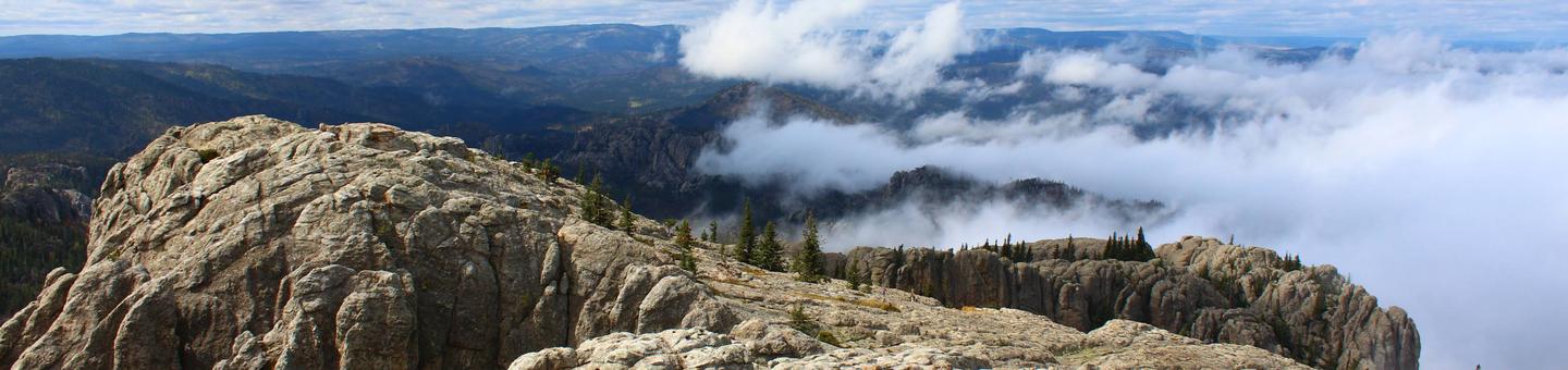
Black Hills National Forest
Access for the Ages
With several national icons nestled among the pines of the Black Hills National Forest, this Island in the Plains serves as the backdrop for these symbols of America. Specialized campgrounds, roaded recreation opportunities and a system of trails connecting communities, showcase this Forest that provides user friendly access to year round family activities. Together the attractive features of the Black Hills National Forest, Custer State Park, and area National Parks, Memorials, and Monuments are the foundation for the local recreation economies.
Amid the splendid scenery of the Black Hills National Forest are 11 reservoirs, 30 campgrounds, 26 picnic areas, 2 scenic byways, 1,300 miles of streams, 13,000 acres of wilderness, 353 miles of trails, and much more.
Use the sidebar menu on the left or right: find an area/find an activity to learn about all the different ways you can enjoy the outdoors in the Black Hills National Forest.
RecAreaDirections
Open with Google Map
Misc
| Stay Limit | |
| Reservable | false |
| Keywords | |
| Map Link | |
| Contact Phone | |
| Contact Email |
Permits info
Facilities
Black Hills National Forest Christmas Tree Permit Tree Permit
COOK LAKE REC AREA Campground
List of CampsitesOverview
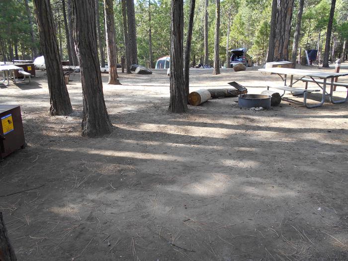
Situated in a heavily forested area adjacent to Cook Lake, this campground is a peaceful setting for guests seeking recreation and relaxation in the Black Hills National Forest in Wyoming. Some sites in the campground are widely spaced and open up to views overlooking the lake, and others sit snugly along a hillside. Separation, rather than vegetation, provide visitors with a sense of privacy. Tall mature trees and grass underbrush give the campground a groomed character.Recreation
The forest offers accessible recreation for all ages. Visitors can take advantage of opportunities for hiking, fishing, horseback riding, mountain biking, and riding off-highway vehicles (OHVs) on moderate terrain. Approximately 4 miles of hiking and bicycling trails are available at the recreation area. Adjacent to the campground is Cook Lake, an ideal spot for fishing and boating. The lake supports populations of rainbow and brown trout, a variety of sunfish, and catfish. The Cook Lake Trail, along with Loop A, has been closed due to a recent landslide. However there are still plenty of opportunities for outdoor recreation of all types in the area.Facilities
The Cook Lake Recreation Area has sites able to accommodate tents, trailers, and RVs. The campground is equipped with picnic tables, campfire rings, vault toilets, and drinking water; however, electrical hook-ups are not available. There is also an accessible pier and picnic area as well as walk in access to the lake for small boats (non motorized).Natural Features
Located in western South Dakota and northeastern Wyoming, Black Hills National Forest encompasses nearly 1.25 million acres of rugged rock formations, canyons and gulches, open grassland parks, tumbling streams, deep blue lakes, and unique caves. Derived from the Lakota language, the words "Paha Sapa," meaning "hills that are black," honor the dark, pine-covered hills rising several thousand feet above the surrounding prairie. Wildlife in the area abounds. Bighorn sheep navigate mountainous terrain, while elk, deer and pronghorn gather in forests and prairies. Bald eagles, hawks, osprey, peregrine falcon, and hundreds of other bird species can be found in the forest, especially along streams, lakes and rivers. Mountain lions, although rarely seen, also call this area home.contact_info
For facility specific information, please call (605) 574-4402.Nearby Attractions
A hike to Warren Peak Lookout Tower makes a scenic day trip for guests.Devils Tower National Monument is also a great location to visit. Established as the first United States National Monument on September 24, 1906, by President Theodore Roosevelt, this unique geological formation is valued for its natural, cultural, and recreational significance.
Charges & Cancellations
No refunds will be given for weather or related events.
REUTER CAMPGROUND Campground
List of CampsitesOverview
Reuter Campground, located on a hillside of Ponderosa pine and grassy understory, offering a peaceful setting for guests seeking recreation and relaxation in northeastern Wyoming's Black Hills National Forest. The campground is named after Emil Reuter, a German immigrant who made his way into the canyon in 1893 and spent the rest of his life prospecting in the area.Recreation
Black Hills National Forest offers a multitude of recreational opportunites throughout all seasons. Hiking, fishing, horseback riding, mountain biking, and riding off-highway vehicles are popular in summer and early autumn. Winter landscapes are ideal for snowshoeing, skiing and snowmobiling.From this campground, visitors can access the Sundance Trail System from Reuter Trailhead. The secluded trails of this system weave through a network of densely forested canyons and open ridges that form the Bearlodge Mountains. Some ridge tops look out to the Custer Expedition Route, Devils Tower, and the Twin Missouri Buttes. Elk, deer and turkey are some of the more common wildlife seen along the trail.
Parts of the trail system have existed since the 1800s. As routes to reliable water and the only access to some parts of the Bearlodge Mountains, they played a key role in the rich mining history of the area.
The trail system is maintained for hiking, horseback riding, bicycling and cross-country skiing. Motorized vehicle traffic is not allowed; however, some portions of trails follow existing Forest Service roads open for motorized use.
Facilities
Reuter Campground has standard sites able to accommodate tents, trailers, and RVs.The campground is equipped with picnic tables, campfire rings, vault toilets, and drinking water. Electrical hook-ups are not available.
Natural Features
Stretching across northeastern Wyoming and western South Dakota, Black Hills National Forest encompasses nearly 1.25 million acres of rugged rock formations, canyons and gulches, open grassland parks, tumbling streams, deep blue lakes, and unique caves.Derived from the Lakota language, the words "Paha Sapa," meaning "hills that are black," honor the dark, pine-covered hills rising several thousand feet above the surrounding prairie.
Bighorn sheep navigate mountainous terrain, while elk, deer and pronghorn gather in forests and prairies. Bald eagles, hawks, osprey, peregrine falcon, and hundreds of other bird species can be found in the forest, especially along streams, lakes and rivers. Mountain lions, although rarely seen, also call this area home.
contact_info
For facility specific information, please call (605) 574-4402.Nearby Attractions
Warren Peak Lookout Tower, approximately 4 miles north of the campground on Forest Service Road 838, provides a panoramic view of the landscape extending into South Dakota and Wyoming.Devils Tower National Monument is also a great location to visit. Established as the first United States National Monument on September 24, 1906, by President Theodore Roosevelt, this unique geological formation is valued for its natural, cultural, and recreational significance.
Charges & Cancellations
No refunds will be given for weather or related events.
BISMARCK LAKE Campground
List of CampsitesOverview
Bismarck Lake Campground is set amidst a scattering of aspen groves and Ponderosa pine on the southeast edge of Bismarck Lake at 5,000 feet. This is a great place for visitors seeking recreation and relaxation in the Black Hills National Forest. Acess to this campground is through Custer State Park near the West Highway 16A entrance. Sites in the campground are widely spaced and open up to views of lakes, providing adequate privacy for visitors.Recreation
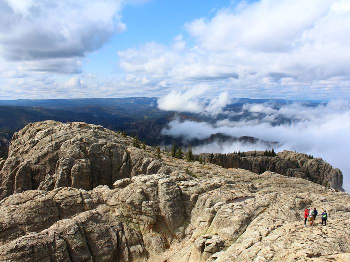
The forest offers accessible recreation for all ages and abilities. Visitors can take advantage of opportunities for hiking, fishing, horseback riding, mountain biking, and riding off-highway vehicles (OHVs) on moderate terrain. At the campground, a short foot trail traverses the forested shoreline, offering opportunities for birding in early morning or picnicking in the afternoon. For those seeking higher elevations, a day-long trek to the summit of nearby Black Elk Peak is worth the effort. Black Elk Peak is the highest natural point in the United States east of the Rocky Mountains. Most of the summit is bare granite and offers expansive views of the surrounding area. An old stone tower (Harney Lookout Tower) at the top, once used as a fire lookout, is still open to hikers. Adjacent to the campground is Bismarck Lake, an ideal spot for fishing and boating. The lake supports populations of rainbow and brown trout, a variety of sunfish, smallmouth bass, northern pike, and catfish.Facilities
Bismarck Lake Campground has sites able to accommodate tents, trailers, and RVs.
Access to the lake is within walking distance and there is a beautiful boardwalk and with fishing piers along the waters edge.
The campground has picnic tables, campfire rings, vault toilets, and drinking water; however, electrical hook-ups are not available.
Natural Features
Located in western South Dakota and northeastern Wyoming, Black Hills National Forest encompasses nearly 1.25 million acres of rugged rock formations, canyons and gulches, open grassland parks, tumbling streams, deep blue lakes, and unique caves.Derived from the Lakota language, the words "Paha Sapa," meaning "hills that are black," honor the dark, pine-covered hills rising several thousand feet above the surrounding prairie.
Wildlife in the area abounds. Bighorn sheep navigate mountainous terrain, while elk, deer and pronghorn gather in forests and prairies. Bald eagles, hawks, osprey, peregrine falcon, and hundreds of other bird species can be found in the forest, especially along streams, lakes and rivers.
contact_info
For facility specific information, please call (605) 574-4402.Nearby Attractions
Possible day trips include Custer State Park with its many buffalo and other wildlife, Crazy Horse Monument and Wind Cave National Park as well as Jewel Cave which is the second longest cave in the world at 159.29 miles. It features sparkling calcite crystals and other rare formations, as well as some of the largest concentrations of passageways in the world.
Bismarck Lake Campground is within a couple of miles of the start of the beautiful Needles Highway scenic drive .
Charges & Cancellations
No refunds will be given for weather or related events.
COMANCHE PARK Campground
List of CampsitesOverview
Situated in an open Ponderosa pine forest 6.5 miles west of Custer, South Dakota, Comanche Park Campground is a campground for visitors seeking recreation and relaxation in the southern Black Hills National Forest.
The campsites are spacious. Towering pine trees provide shade.
This is the closest campground to Jewel Cave National Monument.
Recreation
The forest offers highly accessible recreation for all ages. Visitors can take advantage of opportunities for hiking, fishing, horseback riding, mountain biking, and riding off-highway vehicles (OHVs) on moderate terrain. For those seeking higher elevations, a trek to the summit of nearby Black Elk Peak is worth the effort. Black Elk Peak is the highest natural point in the United States east of the Rocky Mountains. Most of the summit is bare granite and offers expansive views of the surrounding area. An old stone tower at the top, once used as a fire lookout, is still open to hikers.Facilities
Comanche Park Campground has sites able to accommodate tents, trailers, and RVs.The campground is equipped with picnic tables, campfire rings, vault toilets, and drinking water; however, electrical hook-ups are not available.
Natural Features
Located in western South Dakota and northeastern Wyoming, Black Hills National Forest encompasses nearly 1.25 million acres of rugged rock formations, canyons and gulches, open grassland parks, tumbling streams, deep blue lakes, and unique caves. Derived from the Lakota language, the words "Paha Sapa," meaning "hills that are black," honor the dark, pine-covered hills rising several thousand feet above the surrounding prairie. Nearby Jewel Cave is the second longest cave in the world at 159.29 miles. It features sparkling calcite crystals and other rare formations, as well as some of thel argest concentrations of passageways in the world. Wildlife in the area abounds. Bighorn sheep navigate mountainous terrain, while elk, deer and pronghorn gather in forests and prairies. Bald eagles, hawks, osprey, peregrine falcon, and hundreds of other bird species can be found in the forest, especially along streams, lakes and rivers.Nearby Attractions
Possible day trips include Custer State Park with its many buffalo and other wildlife, Crazy Horse Monument and Wind Cave National Park as well as Jewel Cave which is the second longest cave in the world at 159.29 miles. It features sparkling calcite crystals and other rare formations, as well as some of the largest concentrations of passageways in the world.
contact_info
For facility specific information, please call (605) 574-4402.Charges & Cancellations
No refunds will be given for weather or related events.
DUTCHMAN Campground
List of CampsitesOverview
Dutchman Campground, located in a shady Ponderosa pine forested area on the northeast edge of Deerfield Reservoir at 5,000 feet. This camp is an ideal setting for guests seeking recreation and relaxation in Black Hills National Forest.
Sites in the campground are widely spaced, and a few offer wide views of the lake. Of the 3 campgrounds in the Deerfield Recreation Area, this one is the most RV-friendly.
Recreation
Black Hills National Forest offers recreational opportunities for all ages. Guests can take advantage of opportunities for hiking, fishing, horseback riding, mountain biking, and riding off-highway vehicles (OHVs) on moderate terrain.Open to hikers, bikers, and horseback riders, the 10-mile Deerfield Lake Loop Trail encircles Deerfield Lake, traversing the forested shoreline. It offers fantastic views and opportunities for birding and picnicking.
Across the lake, Deerfield Trail connects Deerfield Lake with Rapid Creek and Pactola Reservoir. Sites including a log flume, cabins, mines, tunnels and railroad grades provide visitors with a glimpse into the area's history.
Deerfield Reservoir is an ideal spot for fishing and boating. The lake supports populations of stocked rainbow and native brown trout.
Facilities
Dutchman Campground has sites able to accommodate tents, trailers, and RVs. The campground has picnic tables, campfire rings, vault toilets, and drinking water; however, electrical hook-ups are not available. Lake access is within walking distance. Deerfield Lake is a no wake lake.Natural Features
Located in western South Dakota and northeastern Wyoming, Black Hills National Forest encompasses nearly 1.25 million acres of rugged rock formations, canyons and gulches, open grassland parks, tumbling streams, deep blue lakes, and unique caves.Derived from the Lakota language, the words "Paha Sapa," meaning "hills that are black," honor the dark, pine-covered hills rising several thousand feet above the surrounding prairie.
Wildlife in the area abounds. Bighorn sheep navigate mountainous terrain, while elk, deer and pronghorn gather in forests and prairies. Bald eagles, hawks, osprey, peregrine falcon, and hundreds of other bird species can be found in the forest, especially along streams, lakes and rivers.
contact_info
For facility specific information, please call (605) 574-4402.Nearby Attractions
Possible day trips include Custer State Park with its many buffalo and other wildlife, Crazy Horse Monument and Wind Cave National Park as well as Jewel Cave which is the second longest cave in the world at 159.29 miles. It features sparkling calcite crystals and other rare formations, as well as some of the largest concentrations of passageways in the world
Charges & Cancellations
No refunds will be given for weather or related events.
HORSETHIEF LAKE CAMPGROUND Campground
List of CampsitesOverview
Located 10 miles south of Hill City, South Dakota, Horsethief Lake Campground is a delightful setting for visitors seeking recreation and relaxation in Black Hills National Forest. This campground is 2 miles from Mount Rushmore National Memorial and adjacent to Horsethief Lake. Sites are tucked into a forest of towering ponderosa and lodgepole pine.Recreation
Black Hills National Forest offers visitors a multitude of recreational opportunites throughout all seasons. Hiking, fishing, horseback riding, mountain biking, and riding off-highway vehicles are popular in summer and early autumn. Winter landscapes are ideal for snowshoeing, skiing and snowmobiling. Hundreds of miles of trails and roads offer a variety of terrain for mountain bikers. Hikers and bikers can access the nearby George S. Mickelson Trail, which traverses over 100 miles through the heart of the Black Hills. The majority of the trail follows an abandoned railroad branch line and includes 4 tunnels, over 100 converted railroad bridges, and 15 established trailheads. The trail surface is packed gravel, traversing mountain, meadow, and forest terrain. The trail is named in honor of the former South Dakota governor who crusaded for the trail. For those seeking higher elevations, a day-long trek to the summit of nearby Black Elk Peak is worth the effort. Black Elk Peak is the highest natural point in the United States east of the Rocky Mountains. Most of the summit is bare granite and offers expansive views of the surrounding area. An old stone tower at the top(Harney Lookout Tower), once used as a fire lookout, is still open to hikers.Facilities
Horsethief Lake Campground has sites able to accommodate tents, trailers, and RVs. There are several tent-only and walk-to tent-only sites.The campground is equipped with picnic tables, campfire rings, vault toilets, and drinking water. Electrical hook-ups are not available.
Roads in the campground are paved.
Natural Features
Located in western South Dakota and northeastern Wyoming, Black Hills National Forest encompasses nearly 1.25 million acres of rugged rock formations, canyons and gulches, open grassland parks, tumbling streams, deep blue lakes, and unique caves.Derived from the Lakota language, the words "Paha Sapa," meaning "hills that are black," honor the dark, pine-covered hills rising several thousand feet above the surrounding prairie.
Wildlife in the area abounds. Bighorn sheep navigate mountainous terrain, while elk, deer and pronghorn gather in forests and prairies. Bald eagles, hawks, osprey, peregrine falcon, and hundreds of other bird species can be found in the forest, especially along streams, lakes and rivers.
Nearby Attractions
Explore Mount Rushmore National Memorial, host to almost 3 million visitors a year from across the country and around the world. Visitors may want to inquire about any Independence Day Celebrations taking place on the Mountain.
Possible day trips include Custer State Park with its many Buffalo and other wildlife, Crazy Horse Monument and Wind Cave National Park as well as Jewel Cave which is the second longest cave in the world at 159.29 miles. It features sparkling calcite crystals and other rare formations, as well as some of the largest concentrations of passageways in the world..
contact_info
For facility specific information, please call (605) 574-4402.Charges & Cancellations
No refunds will be given for weather related events.
OREVILLE CAMPGROUND Campground
List of CampsitesOverview
Located 4 miles south of Hill City, South Dakota, Oreville Campground is a delightful setting for guests seeking recreation and relaxation in Black Hills National Forest. The sites are nestled on a hillside among aspen groves, towering ponderosa pines, and grassy areas. Many of the campsites are spacious, offering guests a sense of privacy. The campground is centrally located along Highway 16/385 just north of Crazy Horse Monument with easy access to most Black Hills attractions.Recreation
The forest offers recreation opportunities for all ages and abilities. Guests can take advantage of opportunities for hiking, fishing, horseback riding, mountain biking, and riding off-highway vehicles (OHVs) on moderate terrain. Hundreds of miles of trails and roads offer a variety of terrain for mountain bikers. Hikers and bikers can access the nearby George S. Mickelson Trail, which traverses over 100 miles through the heart of the Black Hills. The majority of the trail follows an abandoned railroad branch line and includes 4 tunnels, over 100 converted railroad bridges, and 15 established trailheads. The trail surface is packed gravel, traversing mountain, meadow, and forest terrain. The trail is named in honor of the former South Dakota governor who crusaded for the trail. For those seeking higher elevations, a day-long trek to the summit of nearby Black Elk Peak is worth the effort. Black Elk Peak is the highest natural point in the United States east of the Rocky Mountains. Most of the summit is bare granite and offers expansive views of the surrounding area. An old stone tower at the top(Harney Lookout Tower), once used as a fire lookout, is still open to hikers.Facilities
Oreville Campground has sites able to accommodate tents, trailers, and RVs. The campground has picnic tables, campfire rings, vault toilets, and drinking water. Electrical hook-ups are not available.Natural Features
Located in western South Dakota and northeastern Wyoming, Black Hills National Forest encompasses nearly 1.25 million acres of rugged rock formations, canyons and gulches, open grassland parks, tumbling streams, deep blue lakes, and unique caves.Derived from the Lakota language, the words "Paha Sapa," meaning "hills that are black," honor the dark, pine-covered hills rising several thousand feet above the surrounding prairie.
Wildlife in the area abounds. Bighorn sheep navigate mountainous terrain, while elk, deer and pronghorn gather in forests and prairies. Bald eagles, hawks, osprey, peregrine falcon, and hundreds of other bird species can be found in the forest, especially along streams, lakes and rivers.
contact_info
For facility specific information, please call (605) 574-4402.Nearby Attractions
Nearby Jewel Cave is the second longest cave in the world at 159.29 miles. It features sparkling calcite crystals and other rare formations, as well as some of the largest concentrations of passageways in the world.Other possible day trips include Mount Rushmore National Memorial, Custer State Park, Crazy Horse Monument and Wind Cave National Park.
Charges & Cancellations
No refunds will be given for weather or related events.
WHITETAIL Campground
List of CampsitesOverview
Whitetail Campground is located above Deerfield Reservoir at 6,000 feet, an ideal setting for guests seeking summer climate relief, recreation and relaxation in Black Hills National Forest. Sites in this campground are widely spaced. Several have lake views, while others are more secluded and tucked into ponderosa and lodgepole pine forest.Recreation
Black Hills National Forest offers recreational opportunities for all ages. Guests can take advantage of opportunities for hiking, fishing, horseback riding, mountain biking, and riding off-highway vehicles (OHVs) on moderate terrain. The 10-mile Deerfield Lake Loop Trail is open to hikers, bikers, and horseback riders. It encircles Deerfield Lake, traversing the forested shoreline and offering fantastic views and opportunities for birding and picnicking. Nearby Deerfield Trail connects Deerfield Lake with Rapid Creek and Pactola Reservoir. Sites along the trail include a log flume, cabins, mines, tunnels and railroad grades, providing a glimpse into the area's history. Deerfield Reservoir is an ideal spot for fishing and boating, but it is a no wake lake. The lake supports populations of stocked rainbow and native brown trout.Facilities
Whitetail Campground has sites able to accommodate tents, trailers, and RVs. Each campsite has picnic tables, and campfire rings. Electrical hook-ups are not available. Lake access is within walking distance.Natural Features
Located in western South Dakota and northeastern Wyoming, Black Hills National Forest encompasses nearly 1.25 million acres of rugged rock formations, canyons and gulches, open grassland parks, tumbling streams, deep blue lakes, and unique caves.Derived from the Lakota language, the words "Paha Sapa," meaning "hills that are black," honor the dark, pine-covered hills rising several thousand feet above the surrounding prairie.
Wildlife in the area abounds. Bighorn sheep navigate mountainous terrain, while elk, deer and pronghorn gather in forests and prairies. Bald eagles, hawks, osprey, peregrine falcon, and hundreds of other bird species can be found in the forest, especially along streams, lakes and rivers.
contact_info
For facility specific information, please call (605) 574-4402.Nearby Attractions
Nearby Jewel Cave is the second longest cave in the world at 159.29 miles. It features sparkling calcite crystals and other rare formations, as well as some of the largest concentrations of passageways in the world.Other possible day trips include Mount Rushmore National Memorial, Custer State Park, Crazy Horse Monument, Devils Tower National Monument and Wind Cave National Park.
Charges & Cancellations
No refunds will be given for weather or related events.
WILLOW CREEK HORSE CAMP Campground
List of CampsitesOverview
This horse camp is nestled at the confluence of Willow Creek and Palmer Creek near the Black Elk Wilderness area of the Black Hills National Forest. From this campground, hikers and horseback riders can access a network of trails into the backcountry. The campground is within the Norbeck Wildlife Preserve. Recently renovated by Forest Service and our Partners, Backcountry Horsemen of America, Willow Creek Campground is a good choice for horse campers.Recreation
Hikers and horseback riders can access the trailhead for the Willow Creek Loop, which provides scenic views of the Black Elk Wilderness. There is also easy access to the Lost Cabin Trail, which offers many views of Black Elk Peak on its descent. Willow Creek Horse Camp provides a good starting point for a day-long hike or horseback ride to Black Elk Peak and Harney Lookout Tower. Both the Willow Creek Loop and the Lost Cabin Trail connect with the Black Elk Peak Trail.Facilities
Each site has a picnic table and campfire ring. Corrals are provided for horses in sites 4 through 9. Each corral accomodates up to 6 horses. A horse waste container is located in the campground and we request that campers remove horse waste from the corrals on departure.
Camping without horses? You may reserve sites 1 through 3 which do not allow horses or choose a site that does accomodate horses. We request that you look at a non-horse site, if available, to accomodate campers with horses. Vault toilets are available. Drinking Water may NOT be available!
Natural Features
The Black Hills in western South Dakota and northeastern Wyoming feature a varied landscape of rugged rock formations, canyons and gulches, open grassland parks, tumbling streams and deep blue lakes. The Black Elk Wilderness is its only wilderness area, and it sits in the center of Norbeck Wildlife Preserve.
Norbeck is home to a variety of wildlife, including elk, deer, bighorn sheep and mountain goats. Its most prominent landmark is Black Elk Peak, which, at 7,242 feet, is the highest
point in the country east of the Rockies.
Nearby Attractions
Named for South Dakota's former governor and U.S. Senator, the Peter Norbeck Scenic Byway offers 70 miles of outstanding sights including Mount Rushmore, which is only 6 miles from the camp, The Needles Highway, Iron Mountain Road and Custer State Park. The Norbeck Overlook provides views of Black Elk Peak and Mount Rushmore.contact_info
For facility specific information, please call (605) 574-4402.Charges & Cancellations
No refunds will be given for weather or related events.
Pactola Reservoir Campground Campground
List of CampsitesOverview
This campground is nestled in the pine trees along the south shore of Pactola Reservoir, offering guests lake views and access to a multitude of recreational opportunities both on land and water. Pactola Visitor Center is located in close proximity to the campground, providing opportunities for conservation education and information to visitors.Recreation
Black Hills National Forest offers recreational opportunities for all ages. Visitors can take advantage of opportunities for hiking, fishing, horseback riding, mountain biking, and riding off-highway vehicles (OHVs) on moderate terrain. From Pactola Reservoir, hikers can access the 2.2-mile Osprey Trail which includes two loop trails and a spur trail to an overlook. The trail is named for the ospreys that are often seen in the area. Pactola Reservoir is an ideal spot for fishing and boating. The reservoir is stocked with rainbow, lake and brown trout as well as largemouth and rock bass, kokanee salmon and yellow perch. Record lake trout are caught here annually, and large brown trout find habitat in Rapid Creek above and below the reservoir.Facilities
Pactola Reservoir Campground has sites able to accommodate tents, trailers, and RVs, including several tent-only sites. Several sites have views of the reservoir. The campground has picnic tables, campfire rings, vault toilets, and drinking water. Electrical hook-ups are not available. Access to the reservoir and beach is within walking distance, and 2 boat ramps are available on-site. A full service marina is nearby, offering basic supplies and services. A National Forest visitor center on the south side of the dam is open seasonally and provides visitors with information about the building of the dam and forest management.Natural Features
Located in western South Dakota and northeastern Wyoming, Black Hills National Forest encompasses nearly 1.25 million acres of rugged rock formations, canyons and gulches, open grassland parks, tumbling streams, deep blue lakes, and unique caves. Derived from the Lakota language, the words "Paha Sapa," meaning "hills that are black," honor the dark, pine-covered hills rising several thousand feet above the surrounding prairie. Pactola Reservoir is the largest and deepest reservoir in the Black Hills, boasting 14 miles of shoreline and 150 foot depths on 800 acres. The Bureau of Reclamation manages the dam and water. Wildlife in the area abounds. Bighorn sheep navigate mountainous terrain, while elk, deer and pronghorn gather in forests and prairies. Bald eagles, hawks, osprey, peregrine falcon, and hundreds of other bird species can be found in the forest, especially along streams, lakes and rivers.contact_info
For facility specific information, please call (605) 574-4402.Nearby Attractions
Nearby Jewel Cave is the second longest cave in the world at 159.29 miles. It features sparkling calcite crystals and other rare formations, as well as some of the largest concentrations of passageways in the world. Other possible day trips include Mount Rushmore National Memorial, Custer State Park, Crazy Horse Monument, Devils Tower National Monument and Wind Cave National Park.Charges & Cancellations
No refunds wil be given for weather or related events.
SHERIDAN LAKE Campground
List of CampsitesOverview
This campground is along the south shore of Sheridan Lake. Within its 5 large loops, there are many sites with direct access to the lake. Access to the south boat ramp and the Flume Trailhead from within the campground and easy access to the South Beach Area, this recreational complex has everything needed for a fun, family camping experience.
Recreation
Black Hills National Forest offers a multitude of recreational opportunites throughout all seasons. Hiking, fishing, horseback riding, mountain biking, and riding off-highway vehicles are popular in summer and early autumn. Winter landscapes are ideal for snowshoeing, skiing and snowmobiling.The Dakota Point Trailhead for the popular Centennial Trail is located on the northeast side of Sheridan Lake, as is the Calumet Trailhead for the Flume Trail.
At 11 miles (plus a 3-mile loop), the Flume Trail has been designated a National Recreation Trail because of its historical significance to the local people. The Rockerville Flume carried water 20 miles, from Spring Creek west of present day Sheridan Lake, east to the placer diggings near Rockerville. The flume operated until 1885, and the trail follows the actual flume bed for much of its length. Along the way are historic artifacts and parts of the flume itself.
Sheridan Lake is an ideal spot for fishing, swimming and boating. The reservoir supports populations of rainbow, brown trout, northern pike and perch. Fly fishing is popular in Spring Creek below the dam, and ice fishing is popular on the lake in winter.
Facilities
Sheridan Lake Campground has sites able to accommodate tents, trailers, and RVs, including 2 tent-only sites. Each campsite has picnic tables, campfire rings, vault toilets, and drinking water. Electrical hook-ups are not available. Access to the lake and beach is within walking distance, and a boat ramp is available on-site.Natural Features
Located in western South Dakota and northeastern Wyoming, Black Hills National Forest encompasses nearly 1.25 million acres of rugged rock formations, canyons and gulches, open grassland parks, tumbling streams, deep blue lakes, and unique caves. Derived from the Lakota language, the words "Paha Sapa," meaning "hills that are black," honor the dark, pine-covered hills rising several thousand feet above the surrounding prairie. Wildlife in the area abounds. Bighorn sheep navigate mountainous terrain, while elk, deer and pronghorn gather in forests and prairies. Bald eagles, hawks, osprey, peregrine falcon, and hundreds of other bird species can be found in the forest, especially along streams, lakes and rivers.contact_info
For facility specific information, please call (605) 574-4402.Nearby Attractions
Nearby Jewel Cave is the second longest cave in the world at 159.29 miles. It features sparkling calcite crystals and other rare formations, as well as some of the largest concentrations of passageways in the world.Other possible day trips include Mount Rushmore National Memorial, Custer State Park, Crazy Horse Monument, Devils Tower National Monument and Wind Cave National Park.
Charges & Cancellations
No refunds will be given for weather or related events.
SUNDANCE Campground
List of CampsitesOverview
Located at the foothills of Bear Lodge Mountain Range, Sundance Horse Camp is a favorite among horse enthusiasts. It makes an ideal base for enjoying recreation and relaxation in Black Hills National Forest. Expansive grassy areas offer scenic views of the valley and surrounding hills. Devils Tower National Monument can be seen from this campground.Recreation
Black Hills National Forest offers a multitude of recreational opportunites throughout all seasons. Hiking, fishing, horseback riding, mountain biking, and riding off-highway vehicles are popular in summer and early autumn. Winter landscapes are ideal for snowshoeing, skiing and snowmobiling. The popular Sundance Trail System can be accessed from this area. The secluded trails of this system weave through a network of densely forested canyons and open ridges that form the Bear Lodge Mountains. Some ridge tops look out to the Custer Expedition Route, Devils Tower, and the Twin Missouri Buttes. Elk, deer and turkey are some of the more common wildlife seen along the trail. Parts of the trail system have existed since the 1800s. As routes to reliable water and the only access to some parts of the Bear Lodge Mountains, they played a key role in the rich mining history of the area. The trail system is maintained for hiking, horseback riding, bicycling and cross-country skiing. Motorized vehicle traffic is not allowed; however, some portions of trails follow existing Forest Service roads open for motorized use.Facilities
Sundance Campground has sites able to accommodate tents, trailers, and RVs. Sites are equipped with picnic tables and campfire rings. Electrical hook-ups are not available. This is a traditional campground with horse use facilities, including large parking areas, corrals, feed bunks, and an accessible rider loading ramp. Metal hitching rails located at the north end of the campground are visible from all campsites. Several trailheads for horseback riding are located at this campground.Natural Features
Stretching across northeastern Wyoming and western South Dakota, Black Hills National Forest encompasses nearly 1.25 million acres of rugged rock formations, canyons and gulches, open grassland parks, tumbling streams, deep blue lakes, and unique caves. Derived from the Lakota language, the words "Paha Sapa," meaning "hills that are black," honor the dark, pine-covered hills rising several thousand feet above the surrounding prairie. Bighorn sheep navigate mountainous terrain, while elk, deer and pronghorn gather in forests and prairies. Bald eagles, hawks, osprey, peregrine falcon, and hundreds of other bird species can be found in the forest, especially along streams, lakes and rivers. Mountain lions, although rarely seen, also call this area home.contact_info
For facility specific information, please call (605) 574-4402.Nearby Attractions
Warren Peak Lookout Tower, approximately 4 miles north of the campground on FSR 838, provides a panoramic view of South Dakota and Wyoming. Devils Tower National Monument is also a great location to visit. Established as the first United States National Monument on September 24, 1906, by President Theodore Roosevelt, this unique geological formation is valued for its natural, cultural, and recreational significance.Charges & Cancellations
No refunds will be given for weather or related events.
BEAR GULCH Campground
List of CampsitesOverview
This private access group campsite is isolated among the forested Black Hills of South Dakota, overlooking a private bay on the Pactola Reservoir. Great for group events with up to 60 people, there are eight individual tent sites around a central parking area. The summers are pleasant, and the bay provides a great way to cool off on sunny days (summer temperatures range from highs in the mid-80s, to lows in the mid-50s). It can be reserved from Memorial Day through Labor Day.
Recreation
Pactola Reservoir is an 800-acre lake, great for water skiing, swimming, fishing and even scuba diving. There is no boat ramp at the campground, but there is a separate marina where you can rent a boat and two boat ramps nearby on the main reservoir. Pactola Point Swim Beach, the Osprey Trail trailhead and a visitor center are within a short drive of the site. Fishing for such sought-after species as brown, rainbow and record lake trout is popular at the reservoir. There is also fishing in nearby Rapid Creek.Facilities
Bear Gulch was formerly an eight-site single family campground, but has been converted into a group campground available for one group reservation at a time. It is primitive, but comfortable. There is a brand new accessible toilet. A hand pump for drinking water is available. Six of eight sites within the facility were originally designated for tent-only camping and still serve that purpose with a flat area, picnic table and fire ring at each site. There are a few places to park an RV around the central parking lot, however turning is very tight. There is no electrical hookup. Vehicles must travel down nine miles of dirt roads to reach the facility. Hill City is the nearest town for additional amenities, and Rapid City is 20 miles away.Natural Features
The campground is in a small canyon surrounded by large Ponderosa pine trees on the southern side of the Pactola Reservoir, the largest reservoir in the Black Hills. This canyon was cut from years of water drainage from the surrounding mountains, forming steep slopes on either side of the road leading to the camping area. A variety of wildlife call the Black Hills home, including mule deer, bighorn sheep, elk and wild turkey. Osprey, also known as fish hawks, are a bird of prey that feed on the abundant fish in the lake.Nearby Attractions
Bear Gulch is centrally located within the Black Hills and its many forests, lakes, mountains and rivers and sightseeing destinations. Mount Rushmore National Memorial, Custer State Park, Crazy Horse Memorial and Spearfish Canyon Scenic Byway are all under an hour away.Mount Rushmore National Memorial
Custer State Park
Charges & Cancellations
No refunds wll be given for weather or related events
ROUBAIX LAKE Campground
List of CampsitesOverview
Roubaix Campground is tucked into a grove of Ponderosa pines along its namesake lake. With a popular swim beach and opportunities for non motorized boating and paddling, campsites are dispersed among four loops, and many offer lake views. At an elevation of 5,500 feet, this camp remains comfortable on hot summer days, and sites are spaced far enough apart to offer ample privacy. This popular camp makes a great base for exploring all the activities and attractions at the lake and in the surrounding area.Recreation
Robaix Lake is ideal for swimming, canoeing, kayaking and fishing for brook and rainbow trout. Horseback riders, mountain bikers and off-road vehicle riders have access to a 1-mile multi-use trail that leads to a network of other trails.Facilities
Roubaix Lake camp offers a variety of sites. Each one contains a gravel spur, picnic table and fire ring.Drinking water and accessible vault toilets are provided.
Natural Features
The Black Hills in western South Dakota and northeastern Wyoming feature a varied landscape of rugged rock formations, canyons and gulches, open grassland parks, tumbling streams and deep blue lakes. This secluded lake is small with a shoreline that borders pine forest.contact_info
For facility specific information, please call (605) 574-4402.Nearby Attractions
The nearby town of Deadwood, South Dakota, is a National Historic Landmark with casinos, Wild West saloons, restaurants and shopping. Mount Rushmore can be reached in under an hour.Charges & Cancellations
No refunds will be given for weather or related events.
IRON CREEK HORSE CAMP Campground
List of CampsitesOverview
Located 13 miles outside Custer, South Dakota, Iron Creek Horse Camp offers a peaceful setting for guests seeking recreation and relaxation in Southeastern South Dakota's Black Hills National Forest. The camp is adjacent to Iron Creek and surrounded by Ponderosa pine forests. Horse enthusiasts will find this setting ideal for exploring wilderness areas and historical sites.Recreation
Black Hills National Forest offers visitors a multitude of recreational opportunites throughout all seasons. Hiking, fishing, horseback riding, mountain biking, and riding off-highway vehicles are popular in summer and early autumn. Winter landscapes are ideal for snowshoeing, skiing and snowmobiling.From this campground, visitors can access the Centennial Trail, and parts of the Black Elk Wilderness and Norbeck Wildlife Preserve. Trails weave through the wilderness offering primitive, non-motorized recreational experiences.
Facilities
This campground has 9 equestrian sites and corrals that can accommodate to 2-3 horses.
Sites have picnic tables, campfire rings with grills, vault toilets and parking areas. Drinking water and electricity are not available.
Water tanks specifically for horses are available.
Access roads to Iron Creek Horse Camp are curvy and the sites can accommodate rigs up to 50 feet in length. For larger rigs, please use Willow Creek Horse Camp.
Natural Features
Stretching across northeastern Wyoming and western South Dakota, Black Hills National Forest encompasses nearly 1.25 million acres of rugged rock formations, canyons and gulches, open grassland parks, tumbling streams, deep blue lakes, and unique caves.Derived from the Lakota language, the words "Paha Sapa," meaning "hills that are black," honor the dark, pine-covered hills rising several thousand feet above the surrounding prairie.
Nearby Black Elk Wilderness lies in the center of the Black Hills National Forest in western South Dakota. The wilderness encompasses the Harney Range, an area long held sacred by American Indians. The wilderness is named after Black Elk, a Oglala Lakota holy man, and is the only wilderness in the Black Hills.
Bighorn sheep navigate mountainous terrain, while elk, deer and pronghorn gather in forests and prairies. Bald eagles, hawks, osprey, peregrine falcon, and hundreds of other bird species can be found in the forest, especially along streams, lakes and rivers. Mountain lions, although rarely seen, also call this area home.
Nearby Attractions
Possible day trips include Custer State Park with its many buffalo and other wildlife, Crazy Horse Monument and Wind Cave National Park as well as Jewel Cave which is the second longest cave in the world at 159.29 miles. It features sparkling calcite crystals and other rare formations, as well as some of the largest concentrations of passageways in the world.
Nearby riding trails treat users to beautiful views throughout their many miles.
contact_info
For facility specific information, please call (605) 574-4402.Charges & Cancellations
No refunds will be given for weather or related events.
SHERIDAN NORTH COVE GRP CG Campground
List of CampsitesOverview
Sheridan North Cove Group Campground, in a forest of Ponderosa pine is along the north shore of Sheridan Lake. This is an ideal setting for large groups and gatherings. Lake views and access to a multitude of recreational opportunities both on land and water draw guests to this part of Black Hills National Forest.Recreation
Black Hills National Forest offers a multitude of recreational opportunites throughout all seasons. Hiking, fishing, horseback riding, mountain biking, and riding off-highway vehicles are popular in summer and early autumn. Winter landscapes are ideal for snowshoeing, skiing and snowmobiling.The Dakota Point Trailhead for the popular Centennial Trail is located on the northeast side of Sheridan Lake, as is the Calumet Trailhead for the Flume Trail.
At 11 miles (plus a 3-mile loop), the Flume Trail has been designated a National Recreation Trail because of its historical significance to the local people. The Rockerville Flume carried water 20 miles, from Spring Creek west of present day Sheridan Lake, east to the placer diggings near Rockerville. The flume operated until 1885, and the trail follows the actual flume bed for much of its length. Along the way are historic artifacts and parts of the flume itself.
Sheridan Lake is an ideal spot for fishing, swimming, boating and water skiing. The lake supports populations of rainbow, brown trout, northern pike and perch. Fly fishing is popular in Spring Creek below the dam, and ice fishing is popular on the lake in winter.
Facilities
Sheridan North Cove Group Campground has 5 group sites able to accommodate tents, trailers, and RVs. Several sites have views of the lake.
Each campsite has picnic tables, campfire rings, vault toilets, and drinking water. Electrical hook-ups are not available.
The north shore has a marina with boat slip rental, groceries and fishing supplies. A large swimming beach, a picnic area and boat launch are also on-site. Fishing piers are located in various areas around the lake. Ollie Otter site is available for reservation only by calling 605-574-4402.
Natural Features
Located in western South Dakota and northeastern Wyoming, Black Hills National Forest encompasses nearly 1.25 million acres of rugged rock formations, canyons and gulches, open grassland parks, tumbling streams, deep blue lakes, and unique caves.Derived from the Lakota language, the words "Paha Sapa," meaning "hills that are black," honor the dark, pine-covered hills rising several thousand feet above the surrounding prairie.
Wildlife in the area abounds. Bighorn sheep navigate mountainous terrain, while elk, deer and pronghorn gather in forests and prairies. Bald eagles, hawks, osprey, peregrine falcon, and hundreds of other bird species can be found in the forest, especially along streams, lakes and rivers.
contact_info
For facility specific information, please call (605) 574-4402.Nearby Attractions
Nearby Jewel Cave is the second longest cave in the world at 159.29 miles. It features sparkling calcite crystals and other rare formations, as well as some of the largest concentrations of passageways in the world.Other possible day trips include Mount Rushmore National Memorial, Custer State Park, Crazy Horse Monument, Devils Tower National Monument and Wind Cave National Park.
Charges & Cancellations
No refunds will be given for weather or related events.
GRIZZLY CREEK PRIMITIVE Campground
List of CampsitesOverview
This campground lies beneath a canopy of oak and Ponderosa pine on the banks of Grizzly Creek. The site has retained much of its original Civilian
Conservation Corps character, and offers visitors recreation and relaxation in Black Hills National Forest. Located along the Iron Mountain Road, it is between Mount Rushmore National Memorial and Custer State Park.
A pavillion built by the Civilian Conservation Corps still stands and is available for use by campers.
Recreation
Black Hills National Forest offers visitors a multitude of recreational opportunites throughout all seasons. Hiking, fishing, horseback riding, mountain biking, and riding off-highway vehicles are popular in summer and early autumn. The winter landscape is ideal for snowshoeing, skiing and snowmobiling. From a nearby trailhead, visitors can access the Centennial Trail and parts of the Black Elk Wilderness and Norbeck Wildlife Preserve. Trails weave through the wilderness for a primitive, non-motorized recreation experience. For those seeking higher elevations, a day-long trek to the summit of nearby Black Elk Peak is worth the effort. Black Elk Peak is the highest natural point in the United States east of the Rocky Mountains. Most of the summit is bare granite and offers expansive views of the surrounding area. An old stone tower (Harney Lookout Tower) at the top, once used as a fire lookout, is still open to hikers.Facilities
Due to tight, sharp turns, towing vehicles is prohibited in this campground. This includes vehicles pulling trailers and fifth-wheels, motorhomes pulling vehicles, and vehicles pulling pop-up campers.
Vehicles up to 24 feet maximum are allowed. No overflow parking available.
The campground has picnic tables, campfire rings, vault toilets, and drinking water. Electrical hook-ups are not available.
Firewood is available for a fee.
Natural Features
Located in western South Dakota and northeastern Wyoming, Black Hills National Forest encompasses nearly 1.25 million acres of rugged rock formations, canyons and gulches, open grassland parks, tumbling streams, deep blue lakes, and unique caves. Derived from the Lakota language, the words "Paha Sapa," meaning "hills that are black," honor the dark, pine-covered hills rising several thousand feet above the surrounding prairie. This campground is located in the Norbeck Wildlife Preserve and is close to the Black Elk Wilderness, South Dakota's only designated wilderness area. This area encompasses the Harney Range, an area long held sacred by American Indians. Wildlife in the area abounds. Bighorn sheep navigate mountainous terrain, while elk, deer and pronghorn gather in forests and prairies. Bald eagles, hawks, osprey, peregrine falcon, and hundreds of other bird species can be found in the forest, especially along streams, lakes and rivers.Nearby Attractions
A short 2 miles away is the fabulous Mount Rushmore National Memorial, which hosts almost 3 million visitors a year.
This campground is located on the scenic Iron Mountain Rd. with its famous CCC built Pigtail Bridges and tunnels for breathtaking views of Mt. Rushmore.
Possible day trips include Custer State Park with its many buffalo and other wildlife, Crazy Horse Monument and Wind Cave National Park as well as Jewel Cave which is the second longest cave in the world at 159.29 miles. It features sparkling calcite crystals and other rare formations, as well as some of the largest concentrations of passageways in the world.
contact_info
For facility specific information, please call (605) 574-4402.Charges & Cancellations
No refunds will be given for weather or related events.
SUMMIT RIDGE LOOKOUT CABIN Campground
List of CampsitesOverview
Summit Ridge Cabin is located near the border of Wyoming in southwestern South Dakota.iin Black Hills National Forest, providing a perfect setting for guests seeking recreation and relaxation.
Built by the Civilian Conservation Corps in the 1930's, the cabin was originally used as housing for personnel that staffed the adjacent forest fire lookout tower. The cabin is available for reservation throughout the year when accessible. At an elevation of 6,096 feet, it can receive considerable snowfall. The roads to the cabin are not plowed, so generally it is not accessible from December through March.
NOTE: Check with local office for snow conditions during winter months.
Recreation
The area around the cabin is remote, yet offers visitors a multitude of recreational opportunities throughout all seasons. Hiking, hunting, fishing, horseback riding, mountain biking, and riding off-highway vehicles are popular in summer and early autumn. Snowshoeing, skiing and snowmobiling offer visitors a chance to seek out winter landscapes. For hikers and bikers, the George S. Mickelson Trail, near Custer, South Dakota (approximately 40 miles from the cabin) traverses over 100 miles through the heart of the Black Hills, with four tunnels, more than 100 converted railroad bridges, and 15 established trailheads spaced along the route. The trail surface is packed gravel, traversing mountain, meadow, and forest terrain.Facilities
The cabin measures 22' x 32' and is comfortable for four people, though groups as large as ten may reserve the facility. The cabin is furnished with three bunk beds. Bedding and mattresses are not provided. The cabin is equipped with a propane stove for cooking, a wood stove for heat and an outdoor fire ring. Guests must provide the propane.Visitors must also bring several of their own supplies as the cabin does not have food, cooking utensils, sleeping bags, sleeping pads, towels, dish soap, matches, pots and pans, toilet paper or garbage bags. Guests must also bring their own firewood and water for cooking, washing and drinking. There is no drinking water available at this site.
Although solar LED lighting is available, an additional light source is recommended. Kerosene lamps are not permitted for fire safety reasons. An accessible vault toilet is located on site and a steel firetower is located near the cabin, but is closed for public use.
Summit Ridge Lookout Cabin also has 2 RV sites at additional $12 each, allowing RVs up to 20 and 30 feet. If you would like to use these RV sites, please enter 11 people, and if you would like both please enter 15 people. The RV sites are not reservable on their own but in addition to the rental of the cabin.
Natural Features
Located in western South Dakota and northeastern Wyoming, Black Hills National Forest encompasses nearly 1.25 million acres of rugged rock formations, canyons and gulches, open grassland parks, tumbling streams, deep blue lakes, and unique caves. Derived from the Lakota language, the words "Paha Sapa," meaning "hills that are black," honor the dark, pine-covered hills rising several thousand feet above the surrounding prairie. Situated in a grassy understory beneath Ponderosa pine, the area around Summit Lookout Cabin exemplifies this landscape. Wildlife in the area abounds. Bighorn sheep navigate mountainous terrain, while elk, deer and pronghorn gather in forests and prairies. Bald eagles, hawks, osprey, peregrine falcon, and hundreds of other bird species can be found in the forest, especially along streams, lakes and rivers.Nearby Attractions
Explore Mount Rushmore National Memorial, host to almost 3 million visitors a year from across the country and around the world. Managed by the National Park Service, visitors will have the opportunity to learn about the birth, growth, development and the preservation of the United States, and take in the beauty of South Dakota's Black Hills. South Dakota caves are some of the most unique in the United States. Boasting sparkling calcite crystals and other rare formations, as well as some of the largest concentrations of passageways in the world, nearby Jewel Cave is currently the second longest in the world, at 180 miles. Other possible day trips include Custer State Park, Crazy Horse Monument and Wind Cave National Park.Spring Creek Trailhead Facility
From Rapid City, travel about 14 miles South/west on Sheridan Lake Road. Spring Creek Trailhead is located .4 miles south of Sheridan Lake Road on National Forest System Road 390. This trailhead serves both the Centennial Trail and the Flume Trail (#50). It is located below Sheridan Lake along Spring Creek.
South Boxelder Trailhead Facility
South Boxelder Trailhead (also known as Blue Draw) provides both motorized and non-motorized access to the Centennial Trail, a National Recreation Trail. The trailhead is a gateway to dozens of miles of OHV trails as well as to some of the most scenic views on the forest. The route between South Boxelder and Pilot Knob to the south is extremely popular during the summer months, and is also one of only a few routes in the Nemo area that is open year-round. The Centennial Trail segments north and south of this trailhead are open for motorized and non-motorized use. Toilets are available further west on the road at the Boxelder Campground.
Access the South Boxelder Trailhead from Rapid City take South Canyon Road west out of Rapid City for approximately 7 miles. South Canyon Road becomes Nemo Road. Travel the Nemo Road northwesterly for 11 miles to the unincorporated town of Nemo. In Nemo, turn west (left) on the Boxelder Forks Road – this is south (before) the Nemo Guest Ranch. After 0.1 mile, the road becomes National Forest System Road (NFSR) 140. Continue west on NFSR 140 for 0.6 miles to the trailhead, which is on the west (left) side of the road.
Black Fox Campground Campground
List of CampsitesThe Black Fox Campground has nine camp sites. Restroom facilities are available. The campground is in a remote location within a spruce forest on South Fork Rapid Creek. The Black Fox Botanical Area is adjacent to the campground. A snowmobile trail with a warming hut is available. The campground is popular on weekends.

Dougherty Trailhead Facility
From Hill City, travel west on Deerfield Road for 5 miles. Turn north (right) onto Mystic Road, and travel for 5.5 miles. This trailhead serves both the Deerfield Trail as well as the Mickelson Trail. The Mickelson Trail is managed by the State of South Dakota. This trailhead has restroom facilities.
Blacktail Trailhead Facility
Blacktail Motorized Trailhead is the primary gateway to dozens of miles of OHV trails west of Cook Lake. The trailhead provides access to extensive OHV routes on the Bearlodge Ranger District and has some of the most challenging routes on the district. The area is also popular with hunters during the fall and typically provides excellent hunting opportunities. Trails are open to OHVs 50-inch wide or less.
Access Blacktail Motorized Trailhead from Hulett, WY via WY Highway 24W travel 1.3 miles southwest to Crook County Road (209) (Black Tail Road). Turn southeasterly (left) on Crook County (Black Tail) Road (209) and proceed for 9.2 miles. Then turn south (right) on National Forest Service Road (NFSR) 849. Proceed for approximately 0.75 mile to the trailhead on the west (right) side of the road.
To access Blacktail Motorized Trailhead from Sundance, (Exit 185 of Interstate 90), travel northwest on US14 for approximately 0.9 miles to Crook County 63, National Forest Service Road (NFSR) 838. Turn north (right) and stay on Warren Peak Road (NFSR 838) for 12.8 miles to NFSR 849 / Taylor County Road. Travel generally north on NFSR 849 approximately 4.6 miles to Blacktail Trailhead, which is on the west (left) side of the road.
Iron Creek West Trailhead (Trail #15) Facility
There are 3 Iron Creek Trailheads. Iron Creek East, Iron Creek West and Iron Creek, which is located in Custer State Park south of Iron Creek Campground. Just outside the southern edge of the Black Elk Wilderness, this is an excellent trail for mountain bikers.
Norbeck Wildlife Preserve & Black Elk Wilderness Facility
The Norbeck Wildlife Preserve lies within the Black Hills National Forest and encompasses Black Elk Wilderness. The Norbeck Organic Act of June 5, 1920 authorized the establishment of the Custer State Park Game Sanctuary “for the protection of game animals and birds and to be recognized as a breeding place therefor”. The Norbeck Wildlife Preserve was established by proclamation, October 9, 1920 by then President Woodrow Wilson. The size of the Norbeck has changed over time, but currently 27,494 acres are administered by the Forest Service. Forest Plan direction states that this area is to be managed to provide habitat for game animals and birds. Some human activities are allowed, but these activities must be consistent with wildlife needs.
Black Elk Wilderness and Norbeck Wildlife Preserve Trail System has eighteen trails ranging in length from 0.6 mile to 8.9 miles. View a Black Elk Wilderness Brochure (.pdf) Unless otherwise noted, the trails listed are open for hikers and stock users only.
Individual Trail Information:
- Lost Cabin Trail (Trail #2), 5.0 miles.
- Norbeck Trail (Trail #3), 6.3 miles.
- Trail #4, 2.3 miles.
- Willow Creek-Rushmore Trail (Trail #5), 1.9 miles.
- Sunday Gulch Trail (Trail #6), 3.2 miles
- Grizzly Bear Creek Trail (Trail #7), 6.3 miles.
- Willow Creek Loop (Trail #8), 2.8 miles.
- Harney Peak (North) Trail (Trail #9), 4.7 miles.
- Harney Peak (South) Trail (Trail #9), 3.8 miles.
- Horsethief Lake Trail (Trail #14), 2.7 miles.
- Iron Creek Trail (Trail #15), 2.4 miles, Difficulty Rating: Easy. Mountain biking allowed.
- Iron Mountain Trail (Trail #16), 1.4 miles.
- A portion of the Centennial Trail (Trail #89), 8.9 miles.
- Centennial Bypass Trail (Trail #89B), 1.7 miles.
- Blackberry Trail, 0.8 mile.
- Sylvan Lakeshore Trail, 1.0 mile, Difficulty Rating: Easy.
- Cathedral Spires Trail, 0.9 mile.
- Little Devils Tower Trail, 0.6 mile.
Black Elk Wilderness and Norbeck Wildlife Preserve Trail System brochures are available at most Ranger District Offices and at the Forest Supervisor's Office.
Antelope Springs Trailhead Facility
Antelope Springs Trailhead. This trailhead is used primarily for motorized vehicles.
Pactola Visitor Center Facility

The Black Hills National Forest Visitor Center is located west of Rapid City on Pactola Reservoir Dam on Highway 385 in the central hills.
Open Daily: 9 a.m. to 5 p.m., 7 days a week, Mid-May - after Labor Day weekend
Phone: (605) 343-8755
Request for Expression of Interest
- Information: The friendly visitor center staff has brochures, maps, and other information to help you plan your visit to the area and forest.
- Exhibits and Programs: The center's exhibits feature wildlife mounts including a bald eagle! An outdoor bulletin board explains the reservoir's history and recreational opportunities. If you have time, stay for an interpretive program given by the staff!
- Black Hills Parks and Forests Association: This non-profit organization has outlets in most Forest Service offices and at the visitor center, and Wind Cave National Park, Jewel Cave National Monument, and Custer State Park. Sales of forest maps, books, and other items support the education programs and facilities on the forest and may be purchased on their website: www.blackhillsparks.org or by calling 605-745-7020 or tollfree at 888-804-9090.
For more information, please contact the Pactola Visitor Center at (605) 343-8755 or any of the other Black Hills National Forest offices.
Dalton Lake Trailhead Facility
Dalton Lake Trailhead is a motorized and non-motorized trailhead for the Centennial Trail, a National Recreation Trail. The Centennial Trail is non-motorized trail north of the Dalton Lake Trailhead and both non-motorized and motorized for OHV use south of the trailhead. The Centennial Trail meanders 12.8 miles north to the Elk Creek Trailhead through Ponderosa Pine forests, across small seasonal streams, and up to vistas along the trail. As one travels south on the Centennial Trail, the trail climbs quickly yielding views of the surrounding forest valleys. It then wanders for approximately 6.1 miles to South Boxelder Trailhead, spending much of that time weaving along the rim rocks overlooking the Vanocker Canyon. Toilets are available at the Dalton Lake Campground.
Access the Dalton Lake Trailhead from Sturgis from Interstate 90 Exit 32. Turn south on Junction Avenue / Vanocker Canyon Road. After 0.5 miles the road becomes Vanocker Canyon Road / Meade County Highway 3C, continue south. Travel for 12.7 miles to the Dalton Lake Road. At the Dalton Lake Road turn east (left) for 4.1 miles past the Dalton Lake Campground, to the Dalton Lake Trailhead. Pass Dalton Lake and its campground. The trailhead is on the north (left) side of the road.. Follow the signs at the trailhead for either motorized or non-motorized use.
Breezy Point Picnic Area Facility
Hear the winds through the pines while getting excellent views of neighboring granite spires and mountains from a scenic overlook point access by a short cement sidewalk from the nearby 5 site picnic area, parking lot and accessible bathroom.
Spearfish Quarry Trailhead Facility
The Forest Service designed the Spearfish Quarry Trailhead for beginners to practice their motorized riding skills. The former gravel pit near the parking area is open to cross-country travel and there are four short trails accessible from the trailhead.
Access the trailhead from Spearfish via Interstate 90, Exit 8, traveling south on McGuigan Road which merges to Tinton Road. Stay on Tinton Road (also National Forest Service Road, NFSR 134) for 1.6 miles. At Trail 8000, turn west (right) and proceed approximately 0.1 mile to the trailhead. [There is also a non-motorized trailhead on the east (left) side of the road as you travel up Tinton. Continue past the non-motorized trailhead another 0.25 mile to TR 8000 to access the motorized trailhead.
Willow Creek Trailhead Facility
Riders and hikers often use the Willow Creek Trail to access Mount Rushmore National Memorial. It descends west to east, with one creek crossing.
Bismarck Lake Facility
Bismarck Lake
Palmer Creek Trailhead (Lost Cabin #2) Facility
One of two National Recreation Trails in the Black Hills, the Palmer Creek Trail (Lost Cabin #2), starts with a steep climb to the Wilderness boundary. Then during a gradual descent, users are treated to numberous views of Harney Peak. This trail is a favorite of many hikers and riders, and is often used as a loop with Harney Trail #9 for a long day outing. Water is available at Nelson Creek and Lost Cabin Creek.
Red Lake Trailhead Facility
The Forest Service designed Red Lake Trailhead for a family experience. The OHV trails travel across old logging roads and through scenic Aspen groves that are particularly nice in the fall. The trails also allow for riders to park their OHVs and access hiking routes, such as Buzzards Roost, that overlook the Spearfish Canyon. The trails are open from May 15 – December 15 to vehicles of 62-inch width or less. OHVs may travel on all routes marked or mapped as open. The gravel pit and piles near the parking area are not open to OHV use.
Access Red Lake Trailhead from Spearfish from Interstate 90, Exit 8, traveling south on McGuigan Road which merges to Tinton Road. Travel on Tinton Road (also National Forest Service Road, NFSR 134) for 13.4 miles. Turn left (east) at NFSR 134.2W. Signs indicate “Red Lake Trailhead” at the intersection of NFSR 134 with NFSR 134.2W. Travel east on NFRS 134.2W for approximately 0.1 mile to the trailhead.
Coon Hollow Trailhead Facility
From Rapid City, travel south on Mt. Rushmore Road (turns into Highway 16) for 12 miles. At the town of Rockerville, exit onto Silver Mountain Road southwest (right). Travel 0.2 miles to the trailhead. this is the easternmost trailhead of the Flume Trail.
Grizzly Bear Creek Trailhead (Trail #7) Facility
The rugged Grizzly Bear Creek Trail(Trail #7) climbs sharply for a 1,500' elevation gain through the most remote areas of the Black Elk Wilderness. It winds through old growth forest, past beaver ponds, and on to towering granite formations and views of Harney Peak. Camping spots near water can be found adjacent to the lower sections of the trail.
Piedmont Trailhead Facility
The Piedmont Trailhead is on the east side of the most popular system of trails in the Northern Hills. The trails west of Piedmont wind through Ponderosa Pine forests, meander through large meadows, and climb to some of the most spectacular vistas in the Black Hills. The majority of the area trails are open from May 15 – Dec 15, with a few trails that stay open year-around.
Access the Piedmont Motorized Trailhead from Rapid City from Interstate 90 to Exit 46. Turn west (left) on Meade County Highway MC-4 / Elk Creek Road. Proceed to the intersection with Sturgis Road and turn north (right) on Sturgis Road. Travel on Sturgis Road for approximately 0.8 miles to Main Street. Turn west (left) on Main Street. Travel on Main Street nearly 0.6 miles through town to National Forest Service Road (NFSR) 144. NFSR 144 is on the left, labeled as “Piedmont Trailhead”. The parking area is visible approximately 200 yards after traveling NFSR 144.
Access the Piedmont Motorized Trailhead from Sturgis from Interstate 90, Exit 44, toward Bethlehem Road. Turn to west (right) on Meade County Highway MC-4A towards Sturgis Rd. Travel south (left) on Sturgis Road towards Piedmont for 0.8 miles. At Main Street, turn right (west). Travel on Main Street nearly 0.6 miles through town to National Forest Service Road (NFSR) 144. NFSR 144 is on the left, labeled as “Piedmont Trailhead”. The parking area is visible approximately 200 yards after traveling NFSR 144.
Hawkwright Trailhead Facility
Hawkwright Trailhead provides access to the Martin ATV Trail system, which is comprised of 52 miles of scenic loop trails open to vehicles 62” or less in width.
Southern Hills - Custer Facility
The Hell Canyon Ranger District is located in the southern third of the Black Hills National Forest, with offices in both Newcastle, WY and Custer, SD.
Northwestern Hills - Sundance Facility
Bearlodge Ranger District (Northwestern Hills) encompasses the northern portion of the Black Hills on the Wyoming side.In the immediate vicinity is trout fishing, access to over 300 miles of snowmobile trails, hunting, hiking and camping. Forest Service campgrounds near Sundance are Cook Lake, Reuter, and Sundance Trailhead.
Sheridan South Picnic Area Facility
The Sheridan South Picnic Area has 93 picnic sites. Restroom facilities are available.
Samelius Trailhead Facility
Samelius Trailhead is located 18 miles west of Rapid City, and 6 miles east of Hill City right off Highway 16. This is the southernmost Trail Head for the Centennial trail in the Central Hills (Mystic District).
Schroeder Trailhead Facility
Access the Schroeder Trailhead from Rapid City. Drive 3 miles west of Rapid City on Nemo Road to Schroeder Road, turn west (left) and proceed through residential area for about 2 miles. The trailhead will be on the left as you approach the Forest boundary.
Ogden Creek Trailhead Facility
The Ogden Creek Motorized Trailhead provides access to four OHV trails southeast of Warren Peak. The trailhead is approximately 10 miles from Sundance and provides close access for local riders. The trails are open to vehicles with 50-inch width or less. This trailhead is also one of the four trailheads serving the 47.3 miles of stacked-loop non-motorized Sundance Trails.
To access the Ogden Creek Motorized Trailhead from Sundance (Exit 185 of Interstate 90), travel northwest on US14 for approximately 0.9 miles to Crook County 63, National Forest Service Road (NFSR) 838. Turn north (right) and stay on Warren Peak Road (NFSR 838) for 6.2 miles to NFSR 839.1. Turn east (right) on NFSR 839.1 and travel approximately 1.5 miles until the road dead-ends at the trailhead.
Silver City Trailhead Facility
From Rapid City, travel west on Highway 44 for about 15 miles. Turn north (right) onto Highway 385 and travel for 1.4 miles, then turn west (left) onto Silver City Road. Travel 4.5 miles west to the town of Silver City. Continue another .5 miles to the end of the road. This trailhead provides access not only to the Deerfield Trail, but also the headwaters of Pactola Reservoir.
Pactola South Boat Launch Facility
Pactola South Boat Launch is 1 of 2 boat ramps available at Pactola Reservoir. Non-motorized and motorized boating activities, including boat fishing is very popular. The reservoir is stocked with rainbow, lake and brown trout as well as largemouth and rock bass, kokanee salmon and yellow perch.
Shanks Trailhead Facility
Access the Shanks Trailhead from Rapid City. Travel Highway 44 west for 5 miles, turn North (right) onto Forest Road 603. Travel 0.5 miles, trailhead will be on left in the bottom of the quarry.
Deer Creek Trailhead Facility
From Rapid City, travel west on Highway 44 for about 15 miles. Turn north (right) onto Highway 385 and travel for 1.4 miles, then turn west (left) onto Silver City Road. Travel .25 miles, trailhead is on right. This trailhead offers access to the Centennial Trail as well as the eastern end of the Deerfield Trail (#40). This is the northernmost Trailhead on the Centennial Trail in the Central Hills (Mystic District).
Little Spearfish Trailhead (Trail #80) Facility
The Little Spearfish Trail is a 6 mile loop that meanders through stands of ponderosa pine, quaking aspen, and paper birch.
Spearfish Creek offers a year round home to the American Dipper. Dippers are small songbirds uniquely adapted to feeding underwater. The common name "dipper" comes from this bird's habit of bending its legs so its entire body moves up and down in a dipping motion Dippers can dive and propel themselves under the water with swimming motions of their wings. In shallow water, they walk along the bottom of streams by grasping stones with their elongated toes. Dippers feed almost exclusively under water on larval forms of aquatic insects including caddisfly, mayfly and stonefly nymphs.
Red Fern Trailhead Facility
Red Fern Trailhead
Riley Hill Trailhead Facility
Riley Hill Trailhead offers extensive access to a wide variety of trails from just south of Roubaix Lake Recreation Area to north of Pactola Reservoir. Trails range from old logging roads for a peaceful OHV ride, to narrow single track for the more adventurous, and have a wide variety in-between. This series of trails has something for almost everyone.
Access the Riley Hill Trailhead from Deadwood, via US Highway 385 south. Travel on US 385 S for 19.5 miles to Rochford Road, turning west (right). Proceed approximately 4.1 miles west towards Rochford, SD. After approximately 4.1 miles turn north (right) on Trail 8214. There are signs along Rochford Road announcing “Riley Hill Trailhead” just before arriving at Trail 8214. After turning on the trail, the trailhead is 100 yards ahead. The Forest Service plans developing the trailhead in 2017, yet it is available for current use.
Veterans Point Picnic Area Facility
The Veterans Point Picnic Area has four picnic sites located along a paved trail. Accessible restroom facilities are available. An accessible fishing pier is located farther down the trail.
Ditch Creek Trailhead Facility
Ditch Creek Trailhead is located about 15 miles west of Hill City on Deerfield Road, then 4 miles south of Deerfield Road on Ditch Creek Road, adjacent to the Ditch Creek Camp Ground.
Dakota Point Trailhead Facility
From Rapid City, travel south/west on Sheridan Lake Road for 15 miles. Turn south (left) onto Dakota Point Road and travel for .25 miles.
Lakota Lake Facility
Lakota Lake is a small lake located southeast of Keystone SD, on US Highway 16A.
Central Hills - Rapid City Facility
The Mystic Ranger District is located in the central portion of the Black Hills National Forest and has an office south of Rapid City, SD.
Calumet Trailhead Facility
Calumet Trailhead is located on the south side of Sheridan Lake (at the south boat launch). Access is through the Sheridan Lake Campground. This also provides access to the Flume Trail (#50).
Coal Ridge Trailhead Facility
Coal Ridge Trailhead. This trailhead is used primarily for motorized vehicles.
Northern Hills-Spearfish Facility
The Northern Hills Ranger District covers the northern portion of the Black Hills on the South Dakota side. Spearfish has nearby access to over 300 miles of snowmobile trails, groomed and ungroomed cross-country ski trails, a 100 mile long hiking trail (Centennial Trail) and many other trails, a 110 mile long biking, hiking and horseback trail (Mickelson Trail), and 2 downhill ski areas (ski areas are near Deadwood, SD - 15 miles away).
Iron Mountain Trailhead (Trail #16) Facility
The 1.4 mile (one way) Iron Mountain Trail provides beautiful views of the Norbeck Wildlife Preserve and the Black Elk Wilderness. A very unusual feature can be seen from the trail near the Iron Mountain Picnic Ground- follow the signs to "Turtle Rock." There is no water along this trail.
North Shore Trailhead Facility
From Hill City go west on Deerfield Road approximately 22 miles to northwest side of lake, turn right or south on Forest Road 461, travel to end of road.
Lakota Lake Picnic Area Facility
The Lakota Lake Picnic Area has six picnic sites located adjacent to the lake.
Deer Creek Trailhead Facility
From Rapid City, travel west on Highway 44 for about 15 miles. Turn north (right) onto Highway 385 and travel for 1.4 miles, then turn west (left) onto Silver City Road. Travel .25 miles, trailhead is on right. This trailhead offers access to the Centennial Trail as well as the eastern end of the Deerfield Trail (#40). This is the northernmost Trailhead on the Centennial Trail in the Central Hills (Mystic District).
Kinney Canyon Trailhead Facility
From Hill City, travel west on Deerfield Road for 10 miles. Turn north (right) onto Slate Prairie Road and travel for 2.8 miles. The trail is just off the road to the west (left). This Trailhead is the westernmost trailhead for the Deerfield Trail (#40).
Reuter Trailhead Facility
Reuter Motorized Trailhead provides access to a large variety of recreation activities. There is immediate access to trails for hiking, biking, horse-back riding, and Nordic skiing – through the Carson Draw Trails. The trailhead is an alternative parking area to the Ogden Creek Trailhead for OHV riders. Finally, it is the primary trailhead for the snowmobile trails that travel up Warren Peak Highway and run the 67 miles through the Bearlodge Mountains. Toilets are available at the Reuter Campground.
To access the Reuter Motorized Trailhead from Sundance (Exit 185 of Interstate 90), travel northwest on US14 for approximately 0.9 miles to Crook County 63, National Forest Service Road (NFSR) 838. Turn north (right) and stay on Warren Peak Road (NFSR 838) for 2.7 miles to the Reuter Motorized Trailhead, which is on the south (left) side of the road, immediately west of the Reuter Campground.
Pilot Knob Trailhead Facility
Pilot Knob trailhead is located on Forest Service Road 208. Traveling north, it provides motorized access to the Centennial Trail and traveling south it provides non-motorized access to the Centennial Trail. There is a restroom here but no water.
Bluebird Trailhead Facility
Bluebird trailhead provides access to the Martin ATV Trail system, which is comprised of 52 miles of scenic loop trails open to vehicles 62” or less in width.
Boulder Hill Trailhead Facility
From Rapid City, travel south on Rushmore Road (turns into Highway 16) for 13 miles, then turn northeast (right) onto Silver Mountain Road. Travel for 0.1 miles then turn north (left) onto Boulder Hill Road. Travel for 2.2 miles, the trailhead will be on the east (right) side of the road. This trailhead is located on Boulder Hill Road about halfway between Sheridan Lake Road and Highway 16. This trailhead is the closest access to Loop B and the Boulder Hill overlook.
Veterans Point Fishing Pier Facility
The Veterans Point Fishing Pier is fully accessible. A paved trail leads from the parking area to the pier.
Gold Run Trailhead Facility
From Hill City, go west on Deerfield Road approximately 14 miles. Just past Gillette Prairie Road you will see signs for the trailhead on the north (right) side of the road.
Richardson Trailhead Facility
Richardson Trailhead provides access to the Martin ATV Trail system, which is comprised of 52 miles of scenic loop trails open to vehicles 62” or less in width.
Spring Creek Trailhead Facility
From Rapid City, travel about 14 miles South/west on Sheridan Lake Road. Spring Creek Trailhead is located .4 miles south of Sheridan Lake Road on National Forest System Road 390. This trailhead serves both the Centennial Trail and the Flume Trail (#50). It is located below Sheridan Lake along Spring Creek.
Custer Trail Trailhead Facility
From Hill City go west on Deerfield Road approximately 23 miles to northwest side of lake, turn right or south on Forest Road 417, travel to end of road. The Custer Trail Trailhead is located adjacent to the Custer Trail Campground.
Iron Creek East Trailhead (Trail #15) Facility
There are 3 Iron Creek Trailheads. Iron Creek East, Iron Creek West and Iron Creek, which is located in Custer State Park south of Iron Creek Campground. Just outside the southern edge of the Black Elk Wilderness, this is an excellent trail for mountain bikers.
Brush Creek Trailhead Facility
From Rapid City, travel about 15 miles west on Highway 44. Turn south (left) onto Highway 385 and continue over Pactola Dam for 4.3 miles. Turn east (left) onto Victoria Lake Road and drive for 2.3 miles. Turn northeast (left) onto Brush Creek Road and drive for .25 miles.
Big Pine Trailhead (Centennial #89) Facility
Big Pine Trail (Centennial #89) is a portion of the 111-mile Centennial Trail that travels from Wind Cave National Park, through Custer State Park, to Bear Butte State Park in the northern Black Hills. Designated as a National Recreation Trail, users on this section are treated to beautiful scenery and relative seclusion.
Old Baldy Trailhead (Trail #66) Facility
The Old Baldy Trail is a 5.7 mile loop with a 0.7 mile spur trail to the summmit of Old Baldy Mountain. The trail meanders through stands of quaking aspen, paper birch, and ponderosa pine.
Beaver Creek Ski System Trailhead Facility
The Beaver Creek Ski Trail system consists of six trails with a total distance of 12.9 miles. The six trails are the Porcupine Trail, Dry Beaver Trail, Highland Trail, Mallo Trail, Sunshine Trail and Highnoon Trail. The Mallo Trail is a groomed snowmobile trail; use caution when skiing on this trail.
Flume Trailheads (Trail #50) Facility
The Flume Trail has been designated a National Recreation Trail because of its historical significance to the local people. The historic Flume trail takes you back in time to the mining boom of the 1880s. The Rockerville Flume carried water 20 miles, from Spring Creek west of the present day Sheridan Lake, east to the placer diggings near Rockerville. The flume operated until 1885, and enabled miners to take over $20 million in gold. The trail follows the actual flume bed for much of its length. Along the way you’ll see historic artifacts, tunnels, and parts of the flume itself. Please treat these historic objects with respect, and leave them in place so that others who follow can enjoy this rich history of the Black Hills.
Dugout Gulch Botanical Trailhead (Trail #77) Facility
The Dugout Gulch Botanical Trail is a 2.3 mile trail plus a 4.4 mile loop trail.
Far from the boreal (northern) forest of the upper Great Lakes region and Canada, is a small unique community know as Dugout Gulch Botanical Area. Relic boreal plants find refuge in the moist, cool gulches. These survivors are referred to as boreal disjuncts.
The boreal forests of Canada once extended as far south as Nebraska. With their retreat at the end of the Ice Age, boreal plants gave way to species adapted to periods of drought and heat. Only where life sustaining moisture averages about 24 inches per year and temperatures remain relatively cool, can these survivors be found.
Sheltered under the cool, green branches of paper birch, ironwood and hazelnut trees, you may find the Rattlesnake Fern, Common Solomon's Seal, Canadian Enchanter's Nightshade, and the Oval-leaved Milkweed. Also lingering in this area are several sedges - Meadow Sedge, Fox-tail Sedge and Rosy Sedge.
Osprey Trailhead (Trail #58) Facility
A 2.2 mile trail that includes two loop trails and a spur trail to an overlook.
The Osprey Trail was appropriately named because ospreys are often seen in the Pactola Lake area. Osprey, also known as fish hawks, are fish-eating specialists, with live fish accounting for about 99 percent of their diet. Osprey are spectacular divers. Once they have sighted their prey, they fold their wings tightly, descend swiftly and enter the water feet first, often submerging completely. Long sharp talons and barbed pads grip the slippery fish. The fish will be carried back to the nest headfirst to make it as aerodynamic as possible.
From Rapid City, travel about 15 miles west on Highway 44. Turn south (left) onto Highway 385 and continue for 2.7 miles. Just after the Pactola Visitor’s Center turn west (right) onto Custer Gulch Road. Wind along the lake, past the beach for 1.4 miles before you turn north (right) following the signs to Pactola Campground. Go all the way through to the end of the campground facility past the fee booth to the trailhead.
The Osprey Trail is maintained for hiking and bicycling. No motorized use is allowed.
Deerfield Trailheads (Trail #40) Facility
The Deerfield Trail is a 23 mile trail connecting the Deerfield Reservoir to the Centennial Trail. Between the Dougherty and Silver City Trailheads, you will wind through the deep canyons along both Slate Creek and Rapid Creek, crossing over 30 bridges.
Cliff Swallow Trailhead (Trail #91) Facility
The Cliff Swallow Trail is a 3.7 mile loop trail.
Cliff swallows nest in the limestone bluffs above Beaver Creek. Look for gourd-shaped mud nests in the rock out-croppings below the ridge. Other wildlife commonly seen along the trail include white-tailed deer, elk, and turkey. Along Beaver Creek, watch for blue herons, beaver, and water dippers. High above, turkey vultures are often seen riding the thermal drafts.
Mountain lions, although rarely seen, also call this area home.
Centennial Trailheads (Trail #89) - Southern Hills Facility
Seven trailheads provide access to the Centennial Trail in the southern Black Hills. The seven trailheads are the Willow Creek Trailhead, Lakota Lake Trailhead, Iron Creek Trailhead, Badger Hole Trailhead, French Creek Trailhead, Highland Creek Trailhead and the Norbeck Trailhead. This portion of the Centennial Trail is approximately 38 miles long, and is open for hiking and backpacking. Horseback riding and mountain biking are allowed on some portions of the trail.
Centennial Trailheads (Trail #89) - Central Hills Facility
Seven trailheads provide access to the Centennial Trail in the central Black Hills. The seven trailheads are Brush Creek Trailhead, Calumet Trailhead, Dakota Point Trailhead, Deer Creek Trailhead, Rapid Creek Trailhead & Fishing access, Samelius Trailhead and Spring Creek Trailhead. This portion of the Centennial Trail is approximately 29 miles long, and is open for hiking, backpacking, horseback riding, and mountain biking.
The Centennial Trail is a 111 mile long trail from Bear Butte State Park to Wind Cave National Park. It marks the 100th anniversary of state hood, 1889 to 1989, and represents the diversity of South Dakota. There are many other trailheads that also access the Centennail Trail across the Forest.
Carson Draw Trail System Trailhead (Trail #87) Facility
The Carson Draw Trail System is a four-season, non-motorized system of trails that wind through Carson Draw. From spring to fall, the trails are busy with hikers, mountain bikers, and horse riders. They are "off the beaten path" and offer solitude to those searching for a more primitive trail experience. Users may find that these trails are much like the Sundance Trail System in their beauty and serenity and offer an even greater level of solitude. Pine, aspen, and oak stands surround the trails and provide diverse habitats for the abundant wildlife in the area.
Parts of the trail system have existed since the 1800s. In the late 1800s and early 1900s, miners and homesteaders made their way into the Bearlodge Mountains and settled. This trail system is named for one of those families, the Carsons.
Individual Trail Information:
- Carson Cut-Across Trail, 0.7 mile, Difficulty Rating: Moderate.
- Carson Draw Trail, 3.8 miles, Difficulty Rating: Moderate.
- Carson Draw Spur 1, 1.0 mile, Difficulty Rating: Moderate.
- Carson Draw Spur 2, 2.0 miles, Difficulty Rating: Moderate.
Sundance Trail System Trailhead (Trail #93) Facility
The Sundance Trail System weaves through the network of densely-forested canyons and winding open ridges that form the Bearlodge Mountains. From some ridge tops you can see the Custer Expedition Route, Devils Tower, and the Twin Missouri Buttes. Elk, deer and turkey are some of the species represented by the abundant wildlife.
The secluded trails provide one of the most primitive recreational opportunities in the Black Hills. Parts of the trail system have existed since the 1800s. They were the routes to reliable water, the only access to some parts of the mountains, and a key part of the rich mining history of the Bearlodge Mountains.
In the late 1800s and early 1900s, miners and homesteaders made their way into the Bearlodge Mountains and settled. The Ogden Family settled in the mouth of what is now Ogden Canyon in 1881. In 1893, a German immigrant, Emil Reuter, also made his way into the canyon to spend the rest of his life prospecting.
As trail users wander through the southern Bearlodge Mountains, they might notice old fire scars. They are remnants of the great Sundance Fire of 1936 that burned 8,200 acres and treatened the town of Sundance.
Individual Trail Information:
- Ogden Creek Trail, 4.8 miles, Difficulty Rating: Moderate.
- Sand Pit Trail, 4.8 miles, Difficulty Rating: Moderate.
- Upper Ogden Trail, 1.5 miles, Difficulty Rating: Moderate.
- East Fork Quarry Trail, 1.2 miles, Difficulty Rating: Moderate.
- Ogden Ridge Trail, 4.3 miles, Difficulty Rating: Difficult.
- Reuter Springs Trail, 3.0 miles, Difficulty Rating: Difficult.
- Richardson Fire Trail, 5.2 miles, Difficulty Rating: Difficult.
- Sheepnose Trail, 5.8 miles, Difficulty Rating: Difficult.
- Sheepnose Mountain Trail, 2.3 miles, Difficulty Rating: Moderate.
- Tent Canyon Trail, 1.5 miles, Difficulty Rating: Moderate.
- Tent Canyon Ridge Trail, 4.1 miles, Difficulty Rating: Difficult.
- West Fork Quarry Trail, 0.5 mile, Difficulty Rating: Moderate.
- Whitetail Trail, 0.5 mile, Difficulty Rating: Moderate.
- Edge Trail, 2.6 miles, Difficulty Rating: Difficult.
- South Fork Trail, 2.8 miles, Difficulty Rating: Difficult.*
- Sundance Trail, 1.9 miles, Difficulty Rating: Difficult.
*The South Fork Trail is not recommended for horse users due to terrain, slope and/or difficulty.
Cook Lake Trailhead (Trail #88) Facility
The Cook Lake Trailhead provides access to Trail 88. Cook Lake Trail is a 1.0 mile trail with some stairs and a stepping-stone crossing of Beaver Creek, the lake’s inlet. The trail generally parallels the lakeshore on the south, east, north, and northwest sides of the lake. Hikers using the trail must “double-back” since the analysis of and safety precautions for a landslide southwest of the lake now bars hiking on the southwest segment of the lakeshore. Much of Trail 88 is fully accessible on the lake’s south and east shores. There are opportunities to see various breeds of ducks and geese, and osprey, blue heron, and bald eagles. In the water near the shore, very large fish called white amur are often seen. These hybrid fish are distant relatives of carp and were introduced into the lake about 15 years ago to help control aquatic vegetation. The Forest Service allows non-motorized boating. Toilets are available at the Cook Lake Recreation Area.
Mountain lions, although rarely seen, also call this area home.
Deerfield Lake Loop Trailheads (Trail #40L) Facility
This 10 mile trail encircles Deerfield Lake. From Reynolds Prairie you'll have great views of the lake. To the south, the trail winds through areas of tall pines and small meadows. This trail can be accessed from four trailheads: Custer Trail Trailhead, North Shore Trailhead, Hill Top Trailhead and the Gold Run Trailhead.
Rimrock Trailhead (Trail #79) Facility
The Rimrock Trail can be accessed from the Little Spearfish Trailhead located near Timon Campground. The trail includes two loop trails and a spur trail that connects to the Old Baldy Trail, for a total of 7.2 miles of trail. The Rimrock Trail meanders through stands of ponderosa pine, quaking aspen, and paper birch.
Crow Peak Trailhead (Trail #64) Facility
A 3.2 mile trail to Crow Peak Summit, with a 0.5 mile spur trail to Beaver Ridge.
Crow Peak is a dominant landmark because of its geological makeup. Billions of years ago, this area was covered by an ocean. Layers of sediment were deposited on the ocean floor, eventually hardening to form limestone and other sedimentary rock layers.
Underground molten rock called magma pushed the sedimentary layers upward forming hills. During the uplifting, crevasses within the limestone hills filled with magma. These flows of magma, called intrusions, cooled to form igneous rock.
The limestone and other sedimentary rock erodes at a faster rate than the harder igneous rock. As the oceans receded, the overlying sedimentary rock eroded, exposing the igneous intrusions. Crow Peak and other peaks you can see from Crow Peak summit, such as Bear Butte, Spearfish Mountain, and Terry Peak, were formed in this manner. Erosion of the igneous rock and the sedimentary rock surrounding these peaks continues to shape the landscape of the Northern Black Hills.
Ditch Creek System Facility
The Ditch Creek Trail System is approximately 15 miles west of Hill City. It is in the high Limestone Plateau of the Black Hills. This 100 mile trail system has a mix of open meadows, thick aspen, dense spruce and, high mountain streams. Most trails are designed for OHV use, and some may be rocky in places. There is one trailhead for this system. Some trails are open yearlong, others open May 15-December 15 as they are shared with the snowmobile system during winter months.
Merritt System Facility
The Merritt Trail System is a 41 mile mix of motorcycle, jeep and OHV trails, located west of Highway 385, south of Rochford Road, and north of Silver City Road. This is a popular area that connects the Minnesota Ridge Trail System of the Northern Hills trails to the Central Hills. While the motorcycle trails may be a little challenging, the remaining trails are excellent for all users. There is one trailhead for parking in this area. Some of these trail are open yearlong, and some are open May - December 15.
Riley Trailhead. From Rapid City, Travel west on Highway 44 for 15 miles, then turn north (right) on Highway 385. Travel on Highway 385 for 4.4 miles. Turn west (left) onto Rochford Road. Proceed approximately 4.1 miles west towards Rochford, SD. After approximately 4.1 miles turn north (right) on Trail 8214. There are signs along Rochford Road announcing “Riley Hill Trailhead” just before arriving at Trail 8214. After turning on the trail, the trailhead is 100 yards ahead. The Forest Service plans developing the trailhead in 2017, yet it is available for current use.
Silver City Parking. This is not a developed Trailhead, but there is a parking area. From Rapid City, Travel west on Highway 44 for about 15 miles, then then turn north (right) on Highway 385. Travel North for 1.4 miles, then turn west (left) onto Silver City Road. Continue for 2.2 miles and at the intersection with Jenney Gulch Road there will be a meadow on the right accessing trail 6208. (Lat 44 6 18 by Long 103 33 42).
Newton System Facility
The Newton Trail System is just west of Hill City about 5 miles nestled between Deerfield Road and Reno Gulch Road. The 50 miles of trail is predominantly designed for OHV use, but there is one motorcycle trail that will challenge you. This trail system is wider and faster than others in the area, and will provide amazing views of Black Elk Peak and the surrounding area. It is not uncommon to see elk and the occasional mountain lion in the area as well.
To access the Newton Trails, travel north out of Hill City on Deerfield Road for 7.7 miles. Turn south (left) onto Newton Fork Road, and continue for 1 mile. Trailhead construction is not complete, but parking is allowed alongside Newton Fork Road. Most of the trails in this system are open May 15 – December 15.
Hell Canyon Trailhead Facility
From Custer, the Hell Canyon Trailhead is approximately 11 miles west on Highway 16. This trail is maintained for hikers, horseback riders and mountain bikers. No motorized use is allowed. The 1/2 of mile of trail climbs at a steep pace with one switchback until you top out on the limestone crest. This trail follows a bench below limestone cliffs and provides outstanding views of Hell Canyon and the surrounding area. The last 2 miles follows a two-track road along the bottom of Hell Canyon drainage.
Nugget System Facility
The Nugget Trail System is a small isolated section of trails but they provide a spectacular views of the Black Hills. There is no trailhead that services these trails. Access is best from Hill City and Highway 385. Travel east on Highway 385 for 1.3 miles, then turn north (left) on China Gulch Road (Forest Road 249). Continue north on China Gulch Road for 8 miles. The trails will be on both sides of Forest Road 249. These trails are open May - December 15.
Dumont Trailhead Facility
Dumont Snowmobile Trailhead provides quick access to a series of snowmobile trails that crisscross the northern and central Black Hills and extend in eastern Wyoming. The trailhead accesses Trail 7 and is a short distance from Trail 2K (leading to the southern trails), Trail 7A (leading to Lead/Deadwood region), and Trail 5 (leading to the western trails).
Access the Dumont Trailhead from Deadwood via US Highways 14A and 85 west, toward Central City/Lead. Continue on US 14A for 7.5 miles to the N. Rochford Road. Turn south (left) on the N. Rochford Road, traveling approximately 5.1 miles to the Dumont Trailhead. The trailhead is on the west (right) side of N. Rochford Road.
Custer Peak Snowmobile Trailhead Facility
The Custer Peak Snowmobile Trailhead is approximately 11 miles south of Deadwood off of US Highway 385. The trailhead provides direct access to snowmobile Trail 7 and is a gateway to 350 miles of snowmobile trails in the Black Hills.
Access the Custer Peak Snowmobile Trailhead from Deadwood via US 385 traveling south for 9.7 miles. At Custer Peak Road turn west (right). Proceed on Custer Peak Road for approximately 0.1 miles to the trailhead parking lot on the north (right) side of the road. If following a GPS, navigate to Mystic Hills Hideaway or the coordinates below. The trailhead is on the right just before the Mystic Hills Hideaway campground.
Buckhorn Snowmobile Trailhead Facility
Buckhorn Snowmobile Trailhead provides direct access to snowmobile Trail 3. This is the closest trailhead for riders coming from Newcastle, Wyoming. The trail is 6.5 miles from Four Corners, WY and provides access to trails that spread across eastern Wyoming and western South Dakota. The trailhead is privately owned so respect private property by remaining on roads, parking lots, and trails, and packing out what you packed in.
Access Buckhorn Snowmobile Trailhead from Newcastle, Wyoming via US Highway 85 North for 23.3 miles to the Buckhorn Trailhead. The trailhead is on the south (right) side of US 85.
Access Buckhorn Snowmobile Trailhead from Sundance, (Exit 187 of Interstate 90) by traveling south on WY Highway 585 S. Stay on WY 585 S for 27.8 miles to Four Corners Junction. Turn east (left) on US Highway 85 N. Travel on US 85 N for 6.5 miles. The trailhead is on the south (right) side of US 85.
Trailshead Snowmobile Trailhead Facility
The Trailshead Snowmobile Trailhead is the epicenter of snowmobiling in the Black Hills. There are nearly ten trails to choose from within a few miles of the trailhead. Those trails extend west into Wyoming, north to Deadwood, and south to Bear Mountain - providing an incredible amount of variety to riders. The trailhead is privately owned so respect private property by remaining on roads, parking lots, and trails, and packing out what you packed in.
Access Trailshead Snowmobile Trailhead from Newcastle, Wyoming via US Highway 85 North for 28.9 miles. The trailhead is on the south (right) side of US 85, approximately 3.3 miles after entering South Dakota.
Access Trailshead Snowmobile Trailhead from Deadwood, via US Highways-14A and 85 S toward Central City / Lead. Continue straight on US-14A for 11.5 miles. At Cheyenne Crossing stay straight (west) on US 85 S for 12.9 miles; the trailhead is on the south (left) side of the highway.
Bogus System Facility
The Bogus Trail System is enclosed by Bogus Jim Road to the north, Norris Peak Road to the east, Highway 44 to the south and Highway 385 to the west. This is a very rough and rocky trail system containing roughly 34 miles of trail. Technical motorcycle trails and “rock crawler” routes are the majority of this trail system. These trails are open yearlong. There is no developed trailhead for these trails, but there are a few popular access points with some parking. Rock crawler trails are best accessed off Bogus Jim Road. From Rapid City, travel West on highway 44 for approximately 11 miles, then turn north (right) onto Norris Peak Road at Johnson Siding. Continue north for about 3 miles then turn west (left) onto Bogus Jim Road. Travel for 2 miles until you come to Forest Road 201.1B on the south (left) side of the road. If you continue for another 0.5 miles, Forest Road 448 accesses another route.
OHV access is best off Highway 44. Travel about 14 miles west of Rapid City on Highway 44. There will be a small meadow on the north (right) side that access the area via Trail 6301. (Lat 44 5 50 by Long 103 29 46)
Motorcycles have 3 options for parking:
1. Norris Peak Road. From Rapid City, travel West on highway 44 for approximately 11 miles, then turn north (right) onto Norris Peak Road at Johnson Siding. Travel 0.5 miles, then turn left onto Norris Peak Lane. At the end of Norris Peak Lane is a small parking area accessing Trail 6310. (Lat 44 5 46 by Long 103 26 10)
2. Highway 44. Travel about 14 miles west of Rapid City on Highway 44. There will be a small meadow on the north (right) side that access the area via Trail 6301. (Lat 44 5 50 by Long 103 29 46)
Forest Road 202/Highway 385. Travel 15 miles west of Rapid City on Highway 44. Turn North (right) onto Highway 385. Continue for approximately 3 miles, then turn right onto Forest Road 202. Follow Forest Road 202 for about 1 mile, then park in the meadow on right. (Lat 44 7 53 by Long 103 32 39).
Buzzards Roost Trailhead Facility
Buzzards Roost is a regional high point located about five miles west of Rapid City. Buzzards Roost has user friendly trails that are of varying difficulty from easier to more difficult. Mountain bikers, hikers and trail runners find the trails at Buzzards Roost suit their needs for recreation close to home in Rapid City. There are dramatic 360 degree views from the rocky limestone summit of Buzzards Roost. This series of stacked loop contains nearly 12 miles of trails. This is the newest trail system on the Mystic Ranger District. It was completed in 2011 by Black Hills Mountain Bike Association through the use of a volunteer agreement. The late Jeramy Rogers, Mystic Ranger District Recreation Technician was instrumental in facilitating the development of the trails at Buzzards Roost. There is a trail here named “Jeramy” in his honor.
From Rapid City, travel west on Highway 44 about 5 miles. The parking area is located on the south (left) side of the Highway visible from the highway.
Georeferenced Buzzard's Roost Map (.pdf)
Porcupine Trailhead Facility
The Porcupine Trail is part of the Beaver Creek Ski Trail system. The Beaver Creek Ski Trail system consists of six trails with a total distance of 12.9 miles.
Victoria System Facility
The Victoria Trail System is about 10 miles southwest of Rapid City off Sheridan Lake Road. It holds roughly 28 miles of trail, most of which is designed for motorcycles. The southern portion of these trails are open year round, while the northern portion is open May 15 - December 15.
Summit System Facility
The Summitt Trail System is about 2 miles south of Hill City. It is a small system with only 5 miles of dedicated OHV trails. It is used heavily by the Palmer Gulch KOA campground which is located nearby. These trails are open year round.
Shanks/Schroeder System Facility
Just minutes west of Rapid City, this combination of 21 miles of trail and numerous roads provide users with everything from wide two tracks, to narrow windy motorcycle trail. The terrain is typical of the eastern Black Hills, with exposed limestone making the trails more technical and rough in areas. There are two trailheads for parking in this area. These trails are open May 15-December 15.
Boxelder Creek Walk-in Fishing Facility
Boxelder Creek Walk-in Fishing allows non-motorized access to an undeveloped segment of Boxelder Creek. The stream has good populations of rainbow and brook trout. Protect the trailhead and stream by remaining on roads, the parking lot, and trails, and packing out what you packed in.
Access the Boxelder Creek Walk-in Fishing from Rapid City take South Canyon Road west out of Rapid City for approximately 7 miles. South Canyon Road becomes Nemo Road. Travel the Nemo Road northwesterly for 11 miles to the unincorporated town of Nemo. In Nemo, turn west (left) on the Boxelder Forks Road – this is south (before) the Nemo Guest Ranch. After 0.1 mile, the road becomes National Forest System Road (NFSR) 140. Continue west on NFSR 140 for 2.1 miles until the road dead-ends at the trailhead.
Warren Peak Fire Lookout Facility
The original Warren Peak Fire Lookout was constructed by the Civilian Conservation Corps in 1938. This tower was ten feet tall with a live-in cab. In 1959, construction began on the Sundance Air Force Station, the world’s first nuclear-powered radar station, located on Warren Peak. The original Warren Peak fire lookout was demolished during the construction. In 1960, a new Warren Peak fire lookout was moved to a peak east of the original lookout. It was constructed with a 54 foot steel tower and cab.
Cement Ridge Fire Lookout Facility
The original Cement Ridge Fire Lookout was built between 1911 and 1913. At that time it was a one-room log cabin with a shingle roof. In 1921, a crow’s nest with a glassed-in house was constructed. A new lookout was finished in 1941. This is the tower that you see today.
Over the years there have been many maintenance projects conducted on the lookout. In 1974, the cab siding, some planks in the catwalk, steps and wall studs were replaced. The interior was repainted, the siding stained, and the catwalk railing and steps were painted. The ground floor window frames and door were also replaced at that time. The lookout is considered eligible for the National Register of Historic Places and was listed on the National Historic Lookout Register on December 30, 1993. Brochure (.pdf)
Custer Peak Fire Lookout Facility
Custer Peak Fire Lookout was built in 1911. In 1935 it was replaced with a cupola building, and by 1941 the Civilian Conservation Corps constructed the fire lookout you see today. The cab is 14 ft. by 14 ft. surrounded by a catwalk. Originally, the tower had a telephone line that ran between Custer Peak and the Bull Dog Ranch. The tower is considered eligible for the National Register of Historic Places. It was listed on the National Historic Lookout Register on Oct. 13, 1990. Brochure (.pdf)
Dalton Lake Facility
Dalton Lake is approximately a 2.8 acre lake on Little Elk Creek. The upstream watershed drains about 2,000 acres. The lake is about 15 feet deep. The Forest Service and South Dakota Game, Fish, and Parks drained and dredged the lake in 2011 - 2012. Dalton Lake has populations of rainbow and brook trout. The South Dakota Game, Fish, and Parks manages the fishing here so prior to fishing consult the state fishing regulations. Shoreline access is good, as is access via a pier. Meade County residents co-sponsored construction of nine dams, including the Dalton Lake dam, to make the County an outstanding recreation area. The dam’s construction began in 1934 and was complete by 1937. Civilian Conservation Corps Companys 787 and 2759V based from Camp Estes near Nemo, SD, built the campground by 1935, and built a “ski slide” on the south side of the creek downstream from the dam. The ski slide fell into disuse. The picnic pavilion in the campground remains in use. There were a few small dams or check dams downstream (east) of the Dalton Lake dam. The Forest Service allows non-motorized boating on Dalton Lake.
Stageyard Trailhead Facility
Stageyard Trailhead provides access to six OHV trails that are open to vehicles 62-inch in width or less. The trails are a popular with hunters during the fall and during the summer the trails provide a family OHV experience. The scenic trails are primarily on old logging roads that wind through Ponderosa Pines and stands of Black Hills Spruce.
Access the Stageyard Trailhead from Cheyenne Crossing (intersection of US Highways 14A and 85) travel 0.1 mile west on US-85 S, and turn south (left) on Hanna Road / National Forest System Road (NFSR) 196. Travel south 3.5 miles, passing Hannah Campground to Long Draw Road (NFSR 209). Turn southwest (right) on Long Draw Road (NFSR 209) and proceed 3.1 miles to the trailhead, which is on the north (right) side. The Forest Service plans developing the trailhead in 2017, yet it is available for current use. The Forest Service allows parking across from the 8150 trail start or along 209, so long as parked vehicles do not interfere with traffic along the road or trails. Toilets are available at Hannah Campground.
Camp 5 Trailhead Facility
The Camp 5 Motorized Trailhead is the most popular gateway to over 10 miles of rock-crawling, 4x4, and OHV routes in the Deadwood area. Many of these trails can be very challenging and test the limits of operators and machines. Several of the trails wind in and out of creek beds, through boulder fields, and up and down waterfalls as they navigate around steep canyons and pine forests. The trails south of the trailhead are popular with 4x4 clubs, rock-crawling enthusiasts, and adventure-seekers throughout the region. The two trails to the west of the trailhead (Trails 8041 and 8040) are popular OHV routes that are enjoyed by ATV riders. Trails are open from May 15 – Dec 15.
To access the Camp 5 Trailhead from Interstate 90: depart from Exit 30 in Sturgis. Turn on SD Highway 34 / Lazelle Street heading west (this will be a right off of I-90 if coming from Spearfish and a left if coming from Rapid City). SD 34 / Lazelle St becomes US Highway 14 ALT / Boulder Canyon Rd after 0.5 miles. Continue on US 14 ALT / Boulder Canyon Rd for 5.4 miles to Camp 5 Rd. Camp 5 Rd is on the south (left) side of the road. Proceed down the hill approximately 100 yards to the parking area on the east (left).
Access the Camp 5 Trailhead from Deadwood by taking Main Street northeast toward Sturgis. Keep right continuing on US Highway14 Alt for 4.9 miles. Turn south (right) onto Camp 5 Rd. Proceed down the hill approximately 100 yards to the parking area on the east (left).
