
Named for a famous Battle between Indians and Fur Trappers in 1841
Medicine Bow-Routt NFs & Thunder Basin NG
Medicine Bow Routt National Forest
Medicine Bow Routt National Forest
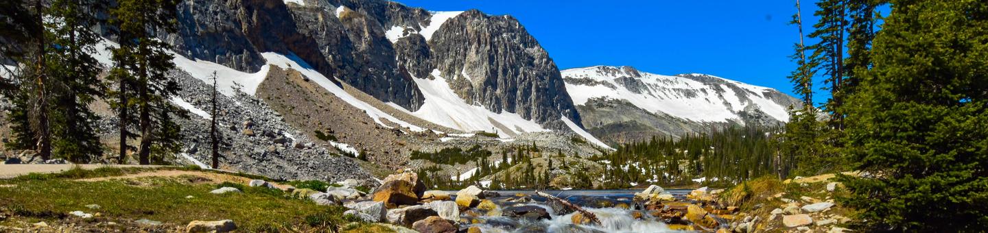
Welcome to Medicine Bow-Routt National Forests and Thunder Basin National Grassland! Visitor opportunities abound on almost 2.9 million acres of National Forest System lands.
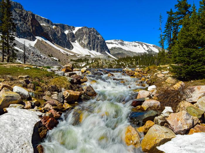
The Medicine Bow and Routt National Forests provide year-round recreation opportunities for you. These activities include hiking, biking, camping, horseriding, OHV riding, fishing and hunting, just to name a few. Beautiful vistas await sightseers and photographers.
The topography varies greatly within the national forests. Elevation ranges from 5,500 to 12,940 feet. The climate ranges from semi-arid at low elevations to colder and less arid in the high country. Frost may occur at any time, and visitors to the higher elevations should be prepared for harsh weather, including snow and high winds, even during the summer months.
The Thunder Basin National Grassland provides unique opportunities for recreation, including hiking, sightseeing, hunting, and fishing. There are no developed campgrounds; however, dispersed camping is allowed. Elevation on the national grassland ranges from 3,600 to 5,200 feet, and the climate is semi-arid.
The following recreation conditions report includes a sampling of our recreation sites. For information on specific sites or areas, use the link to the right or search by activity in the lefthand search bar.
Medicine Bow Routt National Forest
Medicine Bow Routt National Forest
RecAreaDirections
Open with Google Map
Misc
| Stay Limit | |
| Reservable | false |
| Keywords | |
| Map Link | |
| Contact Phone | |
| Contact Email |
Permits info
Facilities
Vedauwoo Gazebo Campground
List of CampsitesOverview
The Gazebo at Vedauwoo offers a covered picnic area surrounded by unique Sherman granite boulders, slabs, and rock formations for groups of up to 30 people to gather in a beautiful outdoor setting. This facility is excellent for small weddings, family gatherings, and picnics.
Recreation
Climbing, hiking, mountain biking, and horseback riding are all popular activities throughout the Vedauwoo area.
Facilities
The Gazebo can accommodate up to 30 guests at a time and 4 parking spots are designated for guests. Please plan vehicle use accordingly. A covered picnic area, grills, and vault toilets are provided, with drinking water available seasonally.
Natural Features
The Gazebo lies within the Vedauwoo picnic area just 15 miles east of Laramie, Wyoming, at an elevation of 8,200 feet.
The Medicine Bow-Routt National Forests and Thunder Basin National Grassland encompasses nearly 3 million acres from central and northeastern Wyoming to north-central Colorado.
Lodgepole pine, aspen, fir, spruce, and shrubs dominate the landscape of the national forests. The Grassland boasts numerous species of grasses and wildflowers that add color to the landscape during warmer months.
Black bear, bobcat, coyote, elk, mule deer, pronghorn antelope, and moose are just some of the many animals that inhabit these rich and diverse lands.
Nearby Attractions
Many more outdoor opportunities exist in the surrounding national forests and grasslands, including hiking, biking, climbing, camping, horseback and off-road vehicle riding, fishing, hunting, sightseeing, and winter sports.
Silver Lake Campground (WY) Campground
List of CampsitesOverview
At just under 10,500 feet Silver Lake Campground is the highest elevation campground on the Brush Creek/Hayden Ranger District. The campground is beside the Snowy Range Scenic Byway on Silver Lake. This facility provides easy access to exploring the trails, lakes, streams, and glacial landscapes of the area.
Recreation
The Snowy Range offers endless recreational activities for any kind of visitor. Specifically, the Snowy Range contains a network of hiking trails suitable for day hiking and for extended, backcountry trips. Additionally, Streams and over 100 lakes in the area provide a variety of challenging recreational-fishing opportunities in the area. Popular attractions near this campground include Silver Lake, Lake Marie Falls, Mirror Lake, Medicine Bow Peak Trail, French Creek Canyon Trail and Miners Cabin Trail. Winter activities in the area include snowshoeing and skiing.
Facilities
Silver Lake Campground has sites able to accommodate tents, trailers and RVs. Sites are equipped with picnic tables and campfire rings. The campground also offers vault toilets, trash receptacles, and potable water.
Natural Features
The Snowy Range rises from sagebrush and lodgepole pine forests in lower elevations to spruce-fir forests and alpine areas in the high country. The area offers views of rugged peaks over 12,000 feet, gorgeous snow-melt lakes and stunning displays of native wildflowers.
Nearby Attractions
Popular attractions near this campground include Silver Lake, Lake Marie Falls, Mirror Lake, Medicine Bow Peak Trail, French Creek Canyon Trail and Miners Cabin Trail. Silver Lake can be acessed using the Silver Lake Trail that surrounds the lake. The lake is 17 acres in size with a maximum water depth of 25 feet. Brook trout reside in the lake.
The Snowy Range Scenic Byway is a 29-mile stretch of paved road crosses through spectacular alpine habitats.
Tie City Campground (WY) Campground
List of CampsitesOverview
Tie City Campground is comprised of 17 campsites in a single tear-drop loop. Some sites are nestled in a dense grove of aspen, fir and spruce, others are in a grassy meadow.
Recreation
The Tie City trailhead leads to a network of challenging mountain bike trails, and is also used in the winter for cross country skiing.
The South Fork of Lodgepole Creek runs close to the Tie City Campground and across the 719 road from Yellow Pine, which has good brook trout fishing.
Facilities
Tie City Campground has sites able to accommodate tents, trailers and RVs. Sites are equipped with picnic tables and campfire rings. The campground also offers vault toilets, trash receptacles, and potable water.
Natural Features
The Medicine Bow-Routt National Forests and Thunder Basin National Grassland encompasses nearly 3 million acres from central and northeastern Wyoming to north-central Colorado.
Lodgepole pine, aspen, fir, spruce, and shrubs dominate the landscape of the national forests. The Grassland boasts numerous species of grasses and wildflowers that add color to the landscape during warmer months.
Black bear, bobcat, coyote, elk, mule deer, pronghorn antelope, and moose are just some of the many animals that inhabit these rich and diverse lands.
Nearby Attractions
Vedauwoo Recreation Area is nearby. Vedauwoo is a group of spectacular granite rock formations rising out of the thin soils on Pole Mountain. The area is a popular destination for rock climbers, hikers, mountain bikers and others who enjoy numerous opportunities to follow their own spirit of play in this gorgeous natural landscape.
South Brush Creek Campground (WY) Campground
List of CampsitesOverview
South Brush Creek Campground is located on the west side of the Snowy Range along the shore of South Brush Creek and is a sunny campground composed of two sections located in a dense stand of Lodgepole pines, fir and Aspen trees next to South Brush Creek.
Recreation
Many hiking, OHV, and fishing opportunities are available in the area.
Facilities
South Brush Creek Campground has sites able to accommodate tents, trailers and RVs. Sites are equipped with picnic tables and campfire rings. The campground also offers vault toilets, trash receptacles, and potable water.
Natural Features
South Brush Creek Campground is situated in a pine, fir and aspen forest forest on the shores of South Brush Creek in the Medicine Bow National Forest in south-central Wyoming. Black bear, bobcat, coyote, elk, mule deer and moose are just some of the many animals that inhabit these rich and diverse lands.
Nearby Attractions
The Snowy Range Scenic Byway is a 29-mile stretch of paved road crosses through spectacular alpine habitats.
Hinman Campground (CO) Campground
List of CampsitesOverview
Hinman Campground, located 22 miles north of Steamboat Springs, Colorado, is a gateway to the Mt. Zirkel Wilderness along the Elk River Corridor with plenty of opportunities for hiking, biking, horseback riding, camping, fishing, river rafting and more.
Recreation
Provides a great gateway for hiking, biking and hunting. Trout fishing is accessible on the river as well as several mountain streams.
Facilities
There are 12 campsites, 6 of which may be reserved. Remaining sites are first-come, first-served. Each site is spacious and equipped with a campfire ring and picnic table.
Natural Features
At an elevation of 7,700 feet, Hinman lies in the Rocky Mountains in the heart of the Routt National Forest near the South Fork of the Elk River. The Medicine Bow-Routt National Forests and Thunder Basin National Grassland encompass nearly three million acres from central and northeastern Wyoming to north-central Colorado. Black bear, bobcat, coyote, elk, mule deer and moose are just some of the many animals that inhabit these rich and diverse lands.
contact_info
For facility specific information, please call (970) 870-2299.Nearby Attractions
Visitors might also enjoy stopping by Steamboat Lake State Park and Hahns Peak Lake Day Use, only a short drive away. Many more outdoor opportunities exist in the surrounding national forests and grasslands, including hiking, biking, camping, horseback and off-road vehicle riding, fishing, hunting, sightseeing and winter sports.
Dry Lake Campground (CO) Campground
List of CampsitesOverview
Dry Lake Campground is located 8 miles northeast of Steamboat Springs, Colorado on the Buffalo Pass Road. This small campground is surrounded by Aspen, Spruce and Fir trees and is in a good location to access some great hiking and biking. Camping limit is 14 days. It is within a reasonable driving distance of community events and the commercially operated Strawberry Park Hot Springs. Dry Lake has 7 campsites with tables and fireplace grates. Vault toilets and trash services are available. Trailer spaces are available with a maximum length of 20 feet.
Recreation
Dry Lake campground provides a great gateway for hiking and biking.
Facilities
There are 7 campsites, 4 of which may be reserved two weeks in advance. Remaining sites are first-come, first-served. Each site is spacious and equipped with a campfire ring and picnic table.
Natural Features
At an elevation of 8,277 feet, Dry lake lies in the Rocky Mountains in the heart of the Routt National Forest. The Medicine Bow-Routt National Forests and Thunder Basin National Grassland encompass nearly three million acres from central and northeastern Wyoming to north-central Colorado. Black bear, bobcat, coyote, elk, mule deer and moose are just some of the many animals that inhabit these rich and diverse lands.
contact_info
For facility specific information, please call (970) 870-2299.Nearby Attractions
There are many attractions with Steamboat Springs only a short drive away. Many more outdoor opportunities exist in the surrounding national forests and grasslands, including hiking, biking, camping, horseback and off-road vehicle riding, fishing, hunting, sightseeing and winter sports.
Meadows Campground (CO) Campground
List of CampsitesOverview
Meadows campground is located on Rabbit Ears Pass in Steamboat Springs, CO and is surrounded by tall evergreens. It has 30 campsites, with a combination of pull-through, back-in and walk-in tent sites, each site having a table and fire ring.
Activities include stream fishing, hiking and mountain biking easily accessible. Camping limit is 14 days. Vault toilets and garbage services provided.
Recreation
Activities include stream fishing, hiking and mountain biking easily accessible. Camping limit is 14 days.
Facilities
Vault toilets and garbage services provided.
Natural Features
At an elevation of 9,300 feet, Meadows campground lies in the Rocky Mountains in the heart of the Routt National Forest on Rabbit Ears pass. The Medicine Bow-Routt National Forests and Thunder Basin National Grassland encompass nearly three million acres from central and northeastern Wyoming to north-central Colorado. Black bear, bobcat, coyote, elk, mule deer and moose are just some of the many animals that inhabit these rich and diverse lands.
contact_info
For facility specific information, please call (970) 870-2299.BOW RIVER RANGER STATION Campground
List of CampsitesOverview
Bow River Ranger Station is a house built in the 1960s for the forest ranger that worked on the northern portion of the Snowy Range.Recreation
The Upper Medicine Bow River flows past the back yard and provides fishing and wildlife viewing.Facilities
The house is all electric with one full bath with two showers, a 1/2 bath, large kitchen, small living room, two bedrooms with two bunk beds in each, a vault toilet outside and fire ring in back yard. The facility is handicap accessible. Cell phone coverage is fair. The kitchen has basic pots, pans, dishes and silverware. Guests are expected to clean the facility before leaving. No trash service; this is a pack-it-in, pack-it-out facility. Sleeps eight.Natural Features
The house sits on the national forest boundary where sagebrush meets the forest.Nearby Attractions
Medicine Bow River, Turpin Reservoir, Sand Lake and Bow River Campground are all nearby.BROOKLYN LAKE Campground
List of CampsitesOverview
Adventurers love sleeping under the towering trees and night sky of the secluded Brooklyn Lake Campground in the mountains of southeastern Wyoming. Located eight miles northwest of Centennial, Wyoming, the facility is situated along a small, picturesque lake at an elevation of 10,500 feet.Recreation
Popular activities include hiking, fishing and non-motorized boating. The 36-acre lake is a nice canoeing spot with calm water. Non-motorized boats are allowed on Brooklyn Lake with carry-down access for boats.Fishing is good for brook trout. From the campground, hikers can access the Sheep Lake and Lost Lake Trails. Sheep Lake Trail also allows horseback riding.
Facilities
All 29 campsites have a view of the lake, and walk-in sites are no more than 25 feet to the water. Campsites are available on a first-come, first-served basis. Other conveniences include campfire rings, trash collection and vault toilets.
Natural Features
The scenery at Brooklyn Lake can't be beat. Pine forests and grasslands surround the lake, and the snow-capped Browns Peak protrudes into the crisp, blue summer sky.The Medicine Bow-Routt National Forests and Thunder Basin National Grassland encompass nearly 3 million acres from central and northeastern Wyoming to north-central Colorado.
Black bear, bobcat, coyote, elk, mule deer and moose are just some of the many animals that inhabit these rich and diverse lands.
Nearby Attractions
Visitors can find many more outdoor opportunities in the surrounding national forests and grasslands, including hiking, biking, camping, horseback riding, fishing, hunting, sightseeing and winter sports.HIDDEN VALLEY PICNIC Campground
List of CampsitesOverview
Hidden Valley Group Picnic Site offers a large open space, surrounded by scenic forests, for groups of up to 300 people to gather amidst a beautiful outdoor setting.This is an excellent facility for family reunions, weddings and large outdoor sporting events and can be used as an overnight campground as well.
Recreation
Volleyball and kickball are popular at this site, but guests must bring their own volleyball.Facilities
The picnic site can accommodate up to 300 guests and 50 vehicles at a time. Vault toilets, drinking water, and grills are provided.
Natural Features
The picnic site lies just east of Laramie, Wyoming, at an elevation of 8,636 feet.
The Medicine Bow-Routt National Forests and Thunder Basin National Grassland encompass nearly 3 million acres from central and northeastern Wyoming to north-central Colorado.
Lodgepole pine, aspen, fir, spruce, and shrubs dominate the landscape of the national forests. The Grassland boasts numerous species of grasses and wildflowers that add color to the landscape during warmer months.
Black bear, bobcat, coyote, elk, mule deer, and moose are just some of the many animals that inhabit these rich and diverse lands.
Nearby Attractions
Many more outdoor opportunities exist in the surrounding national forests and grasslands, including hiking, biking, camping, horseback and off-road vehicle riding, fishing, hunting, sightseeing, and winter sports.
NORTH FORK (WY) Campground
List of CampsitesOverview
North Fork Campground lies along the banks of the North Fork of the Little Laramie River in the Medicine Bow National Forest. The facility is popular for RV camping, fishing, hiking and mountain biking.Recreation
Mountain bikers and hikers have the ease of accessing the scenic, well-known North Fork Trail from the campground. Visitors who would like a more leisurely experience can drive the scenic Highway 130 or take in the view at the North Fork Overlook nearby.Anglers can fish for trout in the clear mountain waters of the North Fork of the Little Laramie.
Facilities
A total of 60 campsites are divided into two sections. Most sites lie along the river banks. Vault toilets and a hand pump for drinking water are provided. A campground host is available for visitor assistance.Natural Features
Located at an elevation of 8,600 feet, the campground sits in a thick forest of lodgepole pine and spruce. The sound of the Little Laramie River can be heard from most campsites.The Medicine Bow-Routt National Forests and Thunder Basin National Grassland encompass nearly 3 million acres from central and northeastern Wyoming to north-central Colorado.
Black bear, bobcat, coyote, elk, mule deer and moose are just some of the many animals that inhabit these rich and diverse lands.
Nearby Attractions
Visitors can find many more outdoor opportunities in the surrounding national forests and grasslands, including hiking, biking, camping, horseback and off-road vehicle riding, fishing, hunting, sightseeing and winter sports.RYAN PARK Campground
List of CampsitesOverview
Ryan Park Campground lies along the Snowy Range Scenic Byway in the Medicine Bow National Forest, at an elevation of 8,000 feet.The site is intriguing for history buffs; it was constructed by the Civilian Conservation Corps in the 1930s and was used as a prisoner of war camp for Italians and Germans during World War II.
Recreation
Visitors can access nearby road cycling routes, stream fishing and day hiking. Scenery abounds in the Snowy Range high country, including the Mirror Lake picnic area, which campers can reach via a paved road from the campground.Although little remains of either of the two historical camps, visitors can learn more from interpretive signs on the facility grounds.
Facilities
Ryan Park boasts 42 campsites and one group campsite. The group site has 14 sites and can host up to 140 visitors.All campsites have picnic tables and campfire rings with grates.
Natural Features
The campground is situated in a mountainous area along Barrett Creek in the Medicine Bow National Forest. The surrounding forest consists of evergreen trees and aspen that turn golden in fall.The Medicine Bow-Routt National Forests and Thunder Basin National Grassland encompass nearly 3 million acres from central and northeastern Wyoming to north-central Colorado.
Black bear, bobcat, coyote, elk, mule deer and moose are just some of the many animals that inhabit these rich and diverse lands.
Nearby Attractions
The historic Brush Creek Visitor Center is located 2.5 miles west of the campground and provides information on various outdoor recreation opportunities, including hiking, biking, camping, horseback and off-road vehicle riding, fishing, hunting, sightseeing and winter sports.Hahns Peak Lake Campground - Medicine-Bow Routt NF (CO) Campground
List of CampsitesOverview
Hahns Peak Lake Campground lies on the shore of a small, scenic lake just 30 miles north of Steamboat Springs, Colorado. Families and outdoor enthusiasts love the abundant hiking, mountain biking and fishing opportunities.With an elevation of 8,500 feet, the campground offers spectacular views of the forested lakeshore, picturesque mountain lake and the 10,774-foot Hahns Peak.
Recreation
The lake provides trout fishing on or off shore, as well as boating for non-motorized or electric motor boats only.Hiking, mountain biking and off-road vehicles can be enjoyed on most of the areas trails, including a popular biking loop on the Prospector Trail. The West Side Lake Trail winds for nearly a mile along the lake shore.
Facilities
Hahns Peak Lake Campground consists of 23 single unit campsites and three double sites for the larger groups. The facility is small but campsites are spacious and private.Natural Features
The campground is situated in a spruce, pine and fir forest along the shore of the 160-acre Hahns Peak Lake in the Routt National Forest of north central Colorado. Lupine and other colorful wildflowers appear throughout the campground in warmer months.The Medicine Bow-Routt National Forests and Thunder Basin National Grassland encompass nearly three million acres from central and northeastern Wyoming to north-central Colorado.
Black bear, bobcat, coyote, elk, mule deer and moose are just some of the many animals that inhabit these rich and diverse lands.
Nearby Attractions
Visitors might also enjoy stopping by Steamboat Lake State Park, only a short drive away, or going into the town of Steamboat Springs, Colorado.Many more outdoor opportunities exist in the surrounding national forests and grasslands, including hiking, biking, camping, horseback and off-road vehicle riding, fishing, hunting, sightseeing and winter sports.
BIG CREEK LAKES CAMPGROUND Campground
List of CampsitesOverview
The popular Big Creek Lakes Campground offers a peaceful, scenic setting in the heart of the Rocky Mountains of northern Colorado. The campground is located in Routt National Forest at an elevation of 9,000-ft., and is adjacent to Big Creek Lake, where fishing, boating and hiking are available.Recreation
This campground offers boating and fishing on Colorado's second largest natural lake, hiking in the Mount Zirkel Wilderness and ATV trails nearby. There are also ample opportunities for viewing wildlife, including moose.Fishing for trout, muskie, grayling and Kokanee salmon is available in the lake. Anglers also have access to a creek. Non-motorized boats are allowed on the upper section of the lake and motorized boats are permitted on the lower section.
Facilities
This facility has a campground and day use area. There are 24 reservable campsites and 30 first-come, first-served campsites, all of which are near Big Creek Lake.Two boat ramps are provided for the convenience of boaters and anglers. A campground host is on-site for visitor assistance.
Natural Features
Big Creek lies among Lodgepole pine and fir trees. Some previously forested areas of the campground have been thinned due to pests and now provide more sun. The campground offers beautiful views of the surrounding wilderness.The wetlands around the lake are prime moose territory. Black bear, bobcat, coyote, elk, mule deer and moose are just some of the many animals that inhabit these rich and diverse lands.
The Medicine Bow-Routt National Forests and Thunder Basin National Grassland, encompass nearly 3 million acres from central and northeastern Wyoming to north-central Colorado.
Nearby Attractions
The closest town is Walden, Colorado, about 35 miles from the campsite. Many more outdoor recreation opportunities exist in the surrounding national forests and grasslands, including hiking, biking, camping, horseback riding, OHV riding, fishing, hunting, sightseeing and winter sports.TEAL LAKE GROUP CAMPSITE Campground
List of CampsitesOverview
Teal Lake Group Campground is set along a small yet scenic lake in north central Colorado in the heart of the Rocky Mountains. Located in the Routt National Forest at an elevation of 9,000-ft., the lake is popular for trout fishing and lies close to a wilderness area with a variety of hiking and off-highway vehicle trails.Recreation
Trout fishing and boating are popular activities in the clear, calm waters of Teal Lake. Only electric boats and non-motorized boats are permitted. Off-road vehicle enthusiasts have easy access to the Grizzly-Helena Trail nearby.Hiking is great in the nearby Mount Zirkel wilderness, though hikers must drive to the trailheads.
Facilities
Teal Lake provides 17 individual campsites and one group site for up to 30 people. Campsites are private and have ample space. The group site has four picnic tables and two campfire rings for groups to gather.Natural Features
Teal Lake is a 50-acre lake surrounded by a rocky shoreline and pine-fir forest. Some previously forested areas of the campground have been thinned due to pests and thus have more sun than others.Black bear, bobcat, coyote, elk, mule deer and moose are just some of the many animals that inhabit the Medicine Bow-Routt National Forests and Thunder Basin National Grassland.
The area is generally snow-free from Memorial Day to Labor Day, but visitors should come prepared for anything, including freezing temperatures and snow during summer.
Nearby Attractions
The closest town is Walden, Colorado. Many more outdoor opportunities exist in the nearly 3 million acres of surrounding national forests and grasslands, including hiking, biking, camping, horseback riding, OHV riding, fishing, hunting, sightseeing and winter sports.LA PRELE GUARD STATION Campground
List of CampsitesOverview
La Prele Guard Station is located south of Douglas, Wyoming in Medicine Bow-Routt National Forest. It was originally built as a remote ranger station in 1936 by the Civilian Conservation Corps and was converted into a work center when the La Prele Ranger District was discontinued in 1956.
The site was listed on the National Register of Historic Places in 1994. Today, it provides a unique lodging experience and delightful spot for guests seeking recreation and relaxation in south central Wyoming.
The guard station is open from early June through late September each year and is accessible by car. Weather and road closures may impact opening and closure dates. Many modern conveniences are provided, but guests will need to bring a few of their own supplies to make their stay comfortable. There is no electricity but the Forest Service provides battery operated lanterns for use. Please note that candles or other flame producing items are not permitted in the cabin.
Recreation
Hiking, fishing, rock climbing, mountain biking, horseback riding and hunting can be found within the vicinity. Off-road vehicle riders can access trails in the area as well.The trailhead for the Twin Peaks trail is three miles north of La Prele Guard Station and provides great access for elk and deer hunters. The trail meanders through both private and public land to the base of Twin Peaks. From the top of the peaks, views of the Laramie Mountains dominate the landscape.
Anglers will enjoy fly fishing for a variety of trout at La Prele Creek within walking distance from the cabin.
Facilities
The log structure has two bedrooms equipped with beds and mattresses that can accommodate up to ten people. The kitchen offers a refrigerator, stove, table with chairs, basic cooking and eating utensils, and cookware. The cabin has indoor plumbing, giving guests access to running water, a shower and a flush toilet; however, it is recommended that you bring drinking water. A propane water heater provides hot water.
The cabin does not have electricity. The fireplace upstairs is usually adequate for heating the guard station during the summer. No flame producing sources are allowed in the cabin, including candles. A campfire ring is just outside.
Guests need to provide their own food, sleeping bags, pillows, towels, dish soap, matches, first aid kit, toilet paper and garbage bags. An emergency light source is recommended. There is no trash collection; all trash, food, and personal items must be taken with you at check out.
Campbell Creek Campground, about 1/2 mile east of the La Prele Guard Station, has six campsites that can accommodate tents, campers and trailers up to 22 feet. Campsite #1 can accommodate a longer trailer of 30 feet.
No Vehicle or ORV driving is allowed off the gravel parking area. Unloading/loading and driving from the parking area to Cold Springs Road is the only driving allowed in the compound.
No additional RV's, campers or tents are allowed without prior approval from the Douglas Ranger District Recreational Specialist.
ORV reminder:
Forest Service Trails require Wyoming ORV sticker and ORV less that 50" in width.
Forest Service Roads require either Wyoming ORV sticker or plated vehicle.
County & State Roads require plated vehicle - including ORV's.
Natural Features
The guard station sits in a grassy clearing surrounded by a mixed conifer forest at an elevation of 7,800 feet. Mountains define the landscape and La Prele Creek flows nearby.
Wildlife viewing is abundant near the cabin, including elk and deer. Migratory birds, squirrels and an occasional black bear find habitat in the forest as well.
Nearby Attractions
Twin Peaks Trail
Little Medicine Falls
Upper Deer Creek Trail
Fishing and Hunting
Rock Climbing on State Trust Land
JACK CREEK CREW QUARTERS Campground
List of CampsitesOverview
The Jack Creek Crew Quarters is a large, modern facility located southwest of Saratoga, Wyoming, offering visitors a comfortable lodging experience in the Medicine Bow-Routt National Forests. The surrounding area offers a variety of recreational opportunities and beautiful scenery to enjoy. The facility is typically open from June through October and is accessible by car. Several modern amenities are offered, but guests will need to bring some of their own supplies and gear. It is recommended guests bring additional light sources and water in case of solar power system problems.Recreation
Opportunities exist in the area for hiking, mountain biking and horseback riding. The Continental Divide National Scenic Trail is five miles west of the house.Anglers can fish in nearby Jack Creek. Big and small game hunting is possible in designated areas.
Facilities
The Jack Creek Crew Quarters has five bedrooms and sleeps up to fifteen people in single and bunk beds with mattresses. The fully equipped double kitchen offers propane ranges, refrigerators and double sinks. Basic cooking and eating utensils, dishes and cookware are furnished. Bathrooms on both floors offer showers and flush toilets. Lights and the well pump are powered by a solar power system, so please don't bring addtional appliances, i.e., microwave. Heat is provided by propane. Picnic tables and a large charcoal grill make a wonderful setting for outdoor activities. Trash collection is provided. Guests are asked to conserve electricity and water usage. No pets are allowed within the building. Pets must be cleaned up after outside. Saddle or pack animals may not be kept within the administrative area of Jack Creek Crew Quarters or Jack Creek Guard Station. Additional campers, tents or trailers cannot be set up at this facility. Guests must bring food, sleeping bags, pillows, towels, dish soap, matches, toilet paper and garbage bags. It is recommended that guests bring an additional light source in case of emergencies. Guests are expected to clean the facility before leaving. Please do not drive behind the locked gate at the trash cans.Natural Features
From open, high expanses to valleys and canyons that rise steeply to snowy ranges, the Medicine Bow-Routt National Forests encompass mountain ranges, tributaries to the North Platte River and the Colorado River, and a mix of forested ecology with spruce, lodgepole pine, subalpine fir, aspen and shrub lands.The Jack Creek Crew Quarters sits in a clearing surrounded by a mixture of lodgepole pine, aspen and mixed conifer forest at an elevation of 8,500 feet. Wildlife viewing is abundant in the area, including elk, deer, bear and moose.
JACK CREEK GUARD STATION Campground
List of CampsitesOverview
The Jack Creek Guard Station is located southwest of Saratoga, Wyoming, offering visitors a unique lodging experience in the Medicine Bow-Routt National Forests.The guard station once served as the northern ranger cabin for the historic Encampment Ranger District. It was constructed by Ranger Evie Williams in 1934. Oral history states that Ranger Williams spent most of his construction dollars on the material for the foundation and chimney, and used his own funds to finish the windows and roof.
The guard station is now listed on the National Register of Historic Places and offers guests recreation and relaxation in a delightful natural setting. The cabin is typically open from mid-June through mid-October and is accessible by vehicle. Basic amenities are provided, but guests will need to pack in some of their own supplies and gear.
Recreation
Opportunities exist in the area for hiking, mountain biking and horseback riding. The Continental Divide National Scenic Trail is approximately five miles west of the cabin. Anglers can fish in nearby Jack Creek and game hunting opportunities are available in designated areas with proper licenses.Facilities
The one-room cabin is furnished with two sets of bunk beds and can accommodate up to four people. Heat is provided by a combination wood and propane cook stove. Basic cooking and eating utensils and propane lights are supplied.
Water is available during the summer months from a hydrant just outside or a hand pump at Jack Creek Campground, one mile away. There is no indoor plumbing, but a vault toilet is located nearby. A picnic table and campfire ring are also outside the cabin. Please use propane side of stove for cooking and heat. There is no trash service; this is a pack-it-in, pack-it-out facility.
Natural Features
From open, high expanses to valleys and canyons that rise steeply to snowy ranges, the Medicine Bow-Routt National Forests encompass mountain ranges, tributaries to the North Platte River and the Colorado River, and a mix of forested ecology with spruce, lodgepole pine, subalpine fir, aspen and shrub lands.The Jack Creek Guard Station sits in a clearing with lodgepole pine, aspen and mixed conifer forest at an elevation of 8,500 feet. Wildlife viewing is abundant in the area, including elk, deer, bear and moose.
Nearby Attractions
BRUSH CREEK WORK CENTER BARRACK Campground
List of CampsitesOverview
The cabin offers an ideal winter playground, with a snowy landscape perfect for recreation. Snowmobiling, skiing and snowshoeing are popular activities. The Brush Creek Cross-Country Ski Trails are made up of loop trails winding through aspen, lodgepole pine stands and reclaimed clear-cuts. The frequency of trail grooming depends on weather conditions and equipment.Recreation
After the Wyoming Highway Department closes their gate for the winter the highway becomes a popular snowmobile trail. The Wyoming State Trails map shows over 300 miles of groomed and ungroomed trail. A new map is created each year.Other recreational opportunities in the area include cross country skiing on the trails behind the Barracks and sledding at the old Ryan Park Ski Area.
Facilities
This bi-level house can accommodate up to eight people comfortably in four bedrooms with a set of twin beds in each. The small living room has a TV, but reception is weak. The large kitchen and dining area is equipped with a refrigerator, stove, microwave, basic kitchen utensils and cooking supplies. Two bathrooms include showers and flush toilets. The house has electricity and heat.Guests should bring a few of their own supplies, including food, sleeping bags, pillows, towels, dish soap, extra toilet paper and garbage bags. Additional light sources should be brought for emergencies. All trash and food should be packed out, and guests are expected to clean the cabin before leaving.
Natural Features
The Snowy Range is aptly named. The Barracks, at 8,100 feet, receives early autumn snow and by Halloween the snow is beginning to accumulate. Eight miles up from the Barracks is the Highway 130 winter closure gate.KEYSTONE RANGER STATION Campground
List of CampsitesOverview
Located deep within the Medicine Bow National Forest, Keystone Cabin offers a unique lodging experience in southeastern Wyoming for guests seeking recreation and relaxation. It is open 11 months of the year, and offers access to a variety of recreational opportunities in all seasons.
The cabin once served as the District headquarters for the Keystone Ranger District, and has been remodeled to preserve the historic value of the cabin while adding a few modern amenities, such as electricity. Due to the rustic and historic nature of the cabin, guests will need to bring a few of their own supplies for a comfortable and enjoyable experience.
During the summer, the cabin is accessible by car, but guests should be prepared to get there in winter by snowmobiling, skiing or snowshoeing five miles from Albany Snowmobile Parking Lot. Please be aware that there may be snow in the area until the end of June and the road can be muddy and bumpy; we recommend calling the USFS Laramie Ranger District office at (307) 745-2300 prior to your reservation to receive the latest weather and road conditions.
Recreation
Hiking, fishing, mountain biking, horseback riding and hunting can be found within the vicinity. Several trailheads are an easy drive from the cabin.In the winter, skiing and snowshoeing are popular activities.
Facilities
The cabin's two bedrooms can sleep up to six people on single beds and bunk beds with mattresses. The cabin has electric lights and heat, but guests can also use the wood-burning stove. The kitchen has a refrigerator, stove, cookware and basic cooking and eating utensils. Drinking water is available. The bathroom has showers and flush toilets. Please be aware that due to recent vandalism, some of the windows are currently under repair and covered with plywood. Restoration efforts are underway and the cabin is still available for rental.
A picnic table and grill provide a delightful area for outdoor dining.
Guests need to provide their own food, sleeping bags, flashlights, pillows, towels, dish soap, matches, first aid kit, toilet paper and garbage bags. All trash and food must be packed out, and guests are expected to clean the cabin before leaving.
There are 2 cabins at the Keystone Ranger Station; one is the rental and the one is sometimes used for employee housing on a temporary basis. Reservation holders will be notified if this is the case.
Natural Features
From open, high expanses to valleys and canyons that rise steeply to snowy ranges, the Medicine Bow-Routt National Forests encompass mountain ranges, tributaries to the North Platte River and the Colorado River, and a mix of forested ecology with spruce, lodgepole pine, subalpine fir, aspen and shrub lands.Keystone Cabin sits in a clearing surrounded by a mixed conifer forest at an elevation of 9,265 feet. Wildlife viewing is abundant near the cabin, including elk, deer and moose. Migratory birds, squirrels and an occasional black bear find habitat in the forest as well.
Charges & Cancellations
Refunds for cancellations may be processed on a case-by-case basis. There are no refunds for reservation processing fees. Please be aware of changes in weather and road conditions prior to arrival and plan accordingly.
GRIZZLY CREEK GUARD STATION Campground
List of CampsitesOverview
At an elevation of 8,500 feet, Grizzly Creek Guard Station is located between Walden and Steamboat Springs, Colorado, offering guests an unique lodging opportunity in the Routt National Forest. The area around the guard station offers a chance to view abundant wildlife and experience a variety of recreational opportunities year-round.The guard station is accessible by passenger vehicle when there is no snow; however, high clearance vehicles are recommended in the spring and fall. Access to the cabin in winter is only available by snowmobile, cross-country skis or snowshoes. The cabin offers some creature comforts, but guests should be prepared to bring some of their own supplies and gear.
Recreation
In summer, hiking and fishing can be found within the vicinity. Trailheads leading to hiking and horseback riding trails are an easy drive from the guard station. Designated areas for off-road vehicles are also near the cabin.In winter, the area is blanketed by snow for wintertime play. Cross-country skiers and snowmobile traffic often pass by the guard station during daylight hours.
Facilities
The historic two-room cabin sleeps five on bunkbeds with mattresses. The cabin has a heater and range powered by propane. The kitchen is equipped with a table and chairs, cooking utensils, pots and pans. An accessible outhouse with pit toilet is also on-site.
Water, electricity, indoor plumbing and trash collection are not available. Water must be hauled from a campground approximately three miles away during the summer. In the winter, guests must provide their own supply of water for cooking, cleaning and washing.
Guests must bring their own food, sleeping bags, lanterns or flashlights, pillows, towels, dish soap, matches, first aid kit, toilet paper and garbage bags. All trash and food should be packed out, and guests are expected to clean the cabin before leaving.
Natural Features
The cabin sits in an open area among grassland and sagebrush, with nearby aspen groves and lodgepole pine forests.The Mount Zirkel Wilderness lies east of the guard station. The wilderness was one of the original areas protected under the 1964 Wilderness Act and has since been expanded twice to its present size of 160,648 acres. The area boasts ecosystems ranging from sagebrush meadows in the lower areas, through pine and spruce/fir forests, to alpine tundra at high elevations.
Elk, deer, moose and other wildlife are often seen in meadows adjacent to the cabin, and cattle frequently pass by the area as well.
LITTLE BROOKLYN LAKE GUARD Campground
List of CampsitesOverview
Little Brooklyn Guard Station is located nine miles west of Centennial, Wyoming just off the Snowy Range Scenic Byway at an elevation of 10,340 feet. The guard station was constructed in 1931 as housing for Forest Service employees. Today, it is a unique year-round lodging experience for guests seeking recreation and relaxation in southeastern Wyoming.
During the dry, summer months, guests can drive directly to the cabin; however during the snowy months, access is limited to snowmobiles, skis or snowshoes. Guests can expect to travel about three miles from the parking lot at Green Rock Recreation Area. Access is limited during the shoulder seasons of spring and fall when snow isnt deep enough to snowmobile on, but too deep to drive in. Please understand these limitations before deciding to reserve the cabin during this time of year.
The cabin offers many modern amenities, but guests should be prepared to pack in some of their own supplies and gear, especially in winter. As stated above, please be aware that there may be snow in the area until mid-July and the road can be muddy, bumpy, or inaccessible; we recommend calling the USFS Laramie Ranger District office at (307) 745-2300 prior to your reservation to receive the latest weather and road conditions.
Recreation
A vast hiking trail system that accesses the highest elevations of the Snowy Range is available within 2 miles of the cabin. Hikers may attempt to summit Medicine Bow Peak, the highest peak in the Range at an elevation of 12,013 feet. Sheep Lakes Trail and Glacier Lakes Trails are also nearby.Fishing is available at many alpine lakes and streams, including Brooklyn Lake and Little Brooklyn Lake, which is within walking distance of the cabin.
Winter brings deep powder snow for the snowmobiler, snowshoer and cross-country skier.
Opportunities exist for hiking, mountain biking, horseback riding and hunting in designated areas nearby.
Facilities
The cabin measures 28x22-ft. and has three rooms. It can accommodate up to seven people with two sets of bunk beds, one single bed and a double sofa bed. The cabin is heated by a wood stove and equipped with propane lights, propane cook stove, cookware and utensils for eating and cooking. The Forest Service supplies the propane and firewood. The firewood will need to be split. A maul and axe are provided. Please leave a good amount of split firewood for the next guest. If there is a problem, report it to the Forest Service.
Drinking water is available during the summer months from a pump located outside the cabin. No running water is available inside the cabin. Water from the pump may freeze during the winter months, so guests must bring their own supply of water or melt snow for drinking, cooking and cleaning during this time. A vault toilet, grill and picnic table are located outside the cabin.
Saddle or pack stock belonging to the renter may be kept in the meadow north of the guard station for an additional fee. Only certified weed-free hay or processed feed may be brought into the National Forest.
Guests need to provide their own food, sleeping bags, lanterns or flashlights, linens, towels, dish soap, matches, first aid kit, toilet paper and garbage bags. All trash and food must be packed out, and guests must clean the cabin before leaving.
Natural Features
From valleys and canyons that rise steeply to jagged ridges, the area around the cabin boasts alpine lakes and a mixed forest of spruce, lodgepole pine, subalpine fir and aspen.In the summer, guests can enjoy a view of wildflowers spilling down the meadow in front of the cabin to the edge of serene Little Brooklyn Lake. In winter, this same meadow is blanketed in pristine snow.
Wildlife is abundant near the cabin, including elk, deer and coyotes. Migratory birds, squirrels and an occasional black bear find habitat in the forest as well.
Nearby Attractions
Guests can travel the Snowy Range Scenic Byway (Highway 130) in the summer. There are many campgrounds, picnic areas and hiking trails along its course. The small Snowy Range Ski Resort is adjacent to this scenic byway as well; however, portions of Highway 130 are not completely accessible during the winter.Charges & Cancellations
Refunds may be processed on a case-by-case basis. There are no refunds for reservation processing fees. Please be aware of changes in weather and road conditions prior to arrival and plan accordingly.
SPRUCE MTN FIRE LOOKOUT TOWER Campground
List of CampsitesOverview
Perched atop a forested mountain, Spruce Mountain Fire Lookout Tower offers visitors a unique lodging experience in Medicine Bow National Forest in southcentral Wyoming. Historically occupied as a fire lookout, the 55-foot tall structure was renovated and opened to the public for overnight rental in 1977.
The lookout is typically open from June through September. Guests can drive directly to the lookout. Several amenities are provided, but guests should be prepared to pack in some of their own supplies and gear for a comfortable stay.
Recreation
The area around the lookout offers opportunities for hiking, mountain biking, horseback riding and hunting. The lookout is also ideal for guests who simply want to relax and enjoy picnics, campfires and stargazing at night. Rob Roy Reservoir is a six mile drive from the lookout, offering opportunities for fishing, boating and water skiing. Gold panning is a popular activity in Douglas Creek, which is connected to the reservoir.Facilities
The lookout cabin is furnished with two single beds with mattresses and can accommodate up to two guests. Inside amenities include a table with chairs, cookware, dishes, utensils, cleaning supplies, a propane heater, propane cook stove and oven and propane lights. An outhouse with pit toilet is provided, and a campfire ring is located at the base of the lookout. Firewood is provided. Additional camping is allowed on-site, though the area is rocky. A hoist (pulley and rope) is available to transport gear to the tower cabin. There is no water or electricity available at the site. Guests must bring enough water for drinking, cooking and washing. Other items to bring include sleeping bags, flashlights or lanterns, towels, dish soap, matches, toilet paper, a first aid kit and garbage bags. All food and trash must be packed out, and guests are expected to clean the cabin before leaving.Natural Features
The lookout offers panoramic views that include Medicine Bow Peak, Rob Roy Reservoir, Jelm Mountain and the southern end of the Snowy Range. Snowdrifts melt in June, welcoming the arrival of wildflowers that splash color on the rocky, timbered hillsides. Wildlife species such as elk, deer, black bears, cougars, squirrels, foxes and bats are supported by the area's diverse forest habitats. At an elevation of 10,003 feet, guests should be prepared for high altitude conditions. Summertime temperatures average 70 degrees fahrenheit, but can drop as low as 30 degrees at night or during thunderstorms.Charges & Cancellations
Refunds for cancellations may be processed on a case-by-case basis. There are no refunds for reservation processing fees. Please be aware of changes in weather and road conditions prior to arrival and plan accordingly.
SANDSTONE CABIN Campground
List of CampsitesOverview
Sandstone Cabin is located west of Encampment, Wyoming, offering guests a unique lodging experience in the Medicine Bow-Routt National Forests. The cabin is typically open from mid-June through October, offering a variety of recreational activities in a beautiful mountain setting.This rustic cabin is located along the scenic Battle Highway, State Highway 70, which makes for easy access by car. Many amenities are offered, but guests will need to bring some of their own supplies and gear.
Recreation
Hiking, fishing, mountain biking, horseback riding and hunting can be found within the vicinity. Several trailheads are an easy drive from the cabin.Anglers will enjoy fly fishing for cutthroat and brook trout at Battle Creek within walking distance from the cabin.
Facilities
The historic cabin is furnished with double beds and bunk beds with mattresses and can accommodate up to six people. Other amenities include a propane cook stove, refrigerator, heater and lights. The kitchen is equipped with basic cooking and eating utensils and cookware. Solar panels provide limited power for lights and small appliances. The bathroom has a shower and flush toilet.Water is available on-site, though it is advised that guests bring their own for drinking. A picnic table and campfire ring provide a delightful area for outdoor dining.
Guests need to provide their own food, sleeping bags, lanterns or flashlights, pillows, towels, dish soap, matches, first aid kit, toilet paper and garbage bags. All trash and food should be packed out, and guests are expected to clean the cabin before leaving. .
No pets are allowed within the building. Pets must be on leash or lead outside to protect wildlife. Pet must be cleaned up after by owner.
Natural Features
From open, high expanses to valleys and canyons that rise steeply to snowy ranges, the Medicine Bow-Routt National Forests encompass mountain ranges, tributaries to the North Platte River and the Colorado River, and a mix of forested ecology with spruce, lodgepole pine, subalpine fir, aspen and shrub lands.Sandstone Cabin sits in a clearing surrounded by a mixture of lodgepole pine, aspen and mixed conifer forest at an elevation of 8,200 feet. Wildlife viewing is abundant in the area, including elk, deer and moose.
Nearby Attractions
Battle Highway, which passes right by the cabin, is a scenic drive featuring historic copper mining sites that were developed from 1897-1908 in the Sierra Madres. The drive is about 58 miles, beginning in Baggs, Wyoming and ending in Riverside, Wyoming. Interpretive signs along the route explain points of interest.HOG PARK CAMPGROUND Campground
List of CampsitesOverview
Hog Park Campground offers a peaceful setting on the southeast shore of Hog Park Reservoir. The campground provides access to the water for boating, fishing and water sports, as well as options for hiking the Continental Divide National Scenic Trail. It lies high in the Medicine Bow-Routt National Forests at an elevation of about 8,400 feet.Recreation
Fishing is excellent for brook and rainbow trout, and boating and water skiing are allowed on Hog Park Reservoir. Two picnic areas are nearby.There are numerous day hiking and backpacking opportunities in the Huston Park, Encampment River and Mount Zirkel Wilderness Areas, all within a short drive.
Facilities
Hog Park has 50 sunny campsites, spread over three loops in the campground. All of these sites are available unless reserved.There are 27 reservable sites in the first two loops: sites 1 through 16, and sites 18,19,31,32 and sites 44 through 50.
The campground recommends tents and small campers for the 22 non-reservable, first come sites on the back loop. These are smaller sites and the loop has a tight turning radius.
Facilities include picnic tables, drinking water, fire grates, vault toilets and trash service. There is a boat ramp near the campground.
Natural Features
The Medicine Bow-Routt National Forests and Thunder Basin National Grassland encompass nearly 3 million acres from central and northeastern Wyoming to north-central Colorado.This campground has been logged to remove all beetle killed trees and is now a sunny campground with a broad view of the reservoir and surrounding mountains. Areas of interest include the Continental Divide, Green Mountain Falls and the Encampment River headwaters.
Seedhouse Group Site - Medicine-Bow Routt NF (CO) Campground
List of CampsitesOverview
Seedhouse Group Site provides a private setting for group gatherings of up to 100 guests. Located near the Elk River, just miles from Steamboat Springs, Colorado, Seedhouse is a retreat for fishing, hiking, biking and horseback riding in the Rocky Mountains.At an elevation of 8,000 feet, the area is also set near the Mount Zirkel Wilderness, which provides for excellent backcountry hiking and camping.
Recreation
The group campsite is a great central location for wilderness hiking and mountain biking, trout fishing in the nearby Elk River and picnicking amidst beautiful mountain scenery.Campers can access the Continental Divide National Scenic Trail via a connector trail within a short drive from the campground.
Facilities
The facility provides eight primitive tent sites with campfire rings and picnic tables, as well as a large picnic shelter that can accommodate 20 guests.Water is available via a hand pump well system. Bear-proof food storage lockers and trash receptacles are provided for visitor safety.
Natural Features
Seedhouse lies in the Rocky Mountains in the heart of the Routt National Forest near the Elk River. The Medicine Bow-Routt National Forests and Thunder Basin National Grassland encompass nearly three million acres from central and northeastern Wyoming to north-central Colorado.Black bear, bobcat, coyote, elk, mule deer and moose are just some of the many animals that inhabit these rich and diverse lands.
Nearby Attractions
Visitors might also enjoy stopping by Steamboat Lake State Park, only a short drive from the campground.Many more outdoor opportunities exist in the surrounding national forests and grasslands, including hiking, biking, camping, horseback and off-road vehicle riding, fishing, hunting, sightseeing and winter sports.
BOTTLE CREEK GROUP PICNIC SITE Campground
List of CampsitesOverview
Bottle Creek Group Picnic Site offers a large area for groups of up to 200 people to gather and enjoy the outdoors. The facility lies at an elevation of 8,800 feet within the Bottle Creek Campground in the Medicine Bow National Forest. The area's year-round recreation opportunities offer something for every adventurer and outdoor lover. Hiking, fishing and camping are available nearby.Recreation
Visitors come to Bottle Creek to picnic, fish, hike, camp and relax in the shade of the forest. Fishing for brown and rainbow trout is available on the Encampment and North Fork Encampment River. The adjacent campground is fairly open and makes an excellent base for fall hunting.Day hiking is popular on the Green Mountain Falls and Encampment River Trails.
Facilities
The Group Picnic Site has numerous large picnic tables, two serving tables, two large pedestal grills and one large wood grill. Approximately 150 feet of picnic table space on site. Camping is not permitted in the group picnic site. However, adjacent campsites in Bottle Creek Campground allow for overnight events. The campground offers 12 campsites available on a first-come, first-served basis, and provides picnic tables, toilets, drinking water and fire grates.Natural Features
The Medicine Bow-Routt National Forests and Thunder Basin National Grassland encompass nearly 3 million acres from central and northeastern Wyoming to north-central Colorado.Lodgepole pine, aspen, fir, spruce and shrubs dominate the landscape of the national forests. The Grassland boasts numerous species of grasses and wildflowers that add color to the landscape during warmer months. The Bottle Creek area is populated with pine and aspen, providing a blanket of shade for picnickers.
Black bear, bobcat, coyote, elk, mule deer and moose are just some of the many animals that inhabit these rich and diverse lands.
Nearby Attractions
Visitors can find many more outdoor opportunities in the surrounding national forests and grasslands, including hiking, biking, camping, horseback and off-road vehicle riding, fishing, hunting, sightseeing and winter sports.SNOW SURVEY CABIN Campground
List of CampsitesOverview
Snow Survey Cabin is located 28 miles southeast of Saratoga, Wyoming, in the Snowy Range of Medicine Bow National Forest. The cabin, located just off the Snowy Range Scenic Byway at nearly 10,000 feet, was built in 1944 and was a shelter for snow surveyors. Today, it is a unique lodging experience for guests seeking rustic recreation and relaxation in southeastern Wyoming. The cabin is open year-round and is accessible by vehicle in good road conditions. Winter access to the facility requires snowmobiling, skiing or snowshoeing up to six miles. Basic amenities are provided, but guests should be prepared to pack in some of their own supplies and gear.Recreation
In the summer months, a vast hiking trail system accessing the highest elevations of the Snowy Range extends from the cabin's back door. Hikers looking for a challenge can make the trek up Medicine Bow Peak at an elevation of 12,013 feet, or hike nearby Browns Peak or Sugarloaf Mountain. Fishing is available at many alpine lakes and streams, including the popular Mirror Lake day use site. Winter brings deep powder snow for the snowmobiler and cross-country skier.Facilities
The one-room cabin is furnished with two sets of bunk beds and can accommodate up to four people. The cabin is equipped with a propane cook stove, heater, solar lights, table and chairs, cookware, and basic cooking and eating utensils. An outhouse with vault toilet is located nearby. No running water is available at the cabin. Guests must bring their own supply of water for drinking, cooking and cleaning. Snow for melting is usually available in winter. Guests need to provide their own food, sleeping bags, lanterns or flashlights, pillows, towels, dish soap, matches, first aid kit, toilet paper and garbage bags. All trash and food must be packed out, and guests are expected to clean the cabin before leaving. No pets are allowed within the building. Pets must be on leash or lead outside to protect wildlife. Pet must be cleaned up after by owner.Natural Features
From valleys and canyons that rise steeply to jagged ridges, the Snowy Range boasts alpine lakes, wildflower meadows and a mixed forest of spruce, lodgepole pine, subalpine fir and aspen. At elevations of 9,000 to 12,000 feet, it lives up to its name, as snow can fall in the area during any month of the year.Wildlife viewing is abundant near the cabin, including elk, deer and moose. Migratory birds, squirrels and an occasional black bear find habitat in the forest as well.
Nearby Attractions
The Snowy Range is transected by Wyoming Highway 130 between Laramie and Saratoga. This is the Snowy Range Scenic Byway. Many campgrounds, picnic areas and hiking trails are located along its course. The small Snowy Range Ski Resort is accessible from this scenic byway as well; however, portions of Highway 130 are not completely accessible during the winter.SEEDHOUSE GUARD STATION Campground
List of CampsitesOverview
Seedhouse Guard Station is located approximately 26 miles north of Steamboat Springs, Colorado. It was constructed in 1933 and offers a unique lodging opportunity for guests seeking recreation and relaxation in the Routt National Forest.
This historic cabin is available for rent in the fall and winter. Guests can drive directly to the cabin when the roads are clear; however, winter access is only available by snowmobiling, cross-country skiing or snowshoeing over three miles from the end of the plowed road. The cabin offers some amenities, but guests need to pack in several of their own supplies.
Recreation
Trailheads leading to hiking and horseback riding trails are an easy drive from the guard station. The Continental Divide National Scenic Trail passes near the cabin through the Mt. Zirkel Wilderness.Anglers can fish for trout in the Elk River.
In winter, the area is blanketed by snow for wintertime play. Snowmobiling, skiing and snowshoeing are popular activities. All motorized activity, including snowmobiling, is prohibited in wilderness areas.
Facilities
The historic guard station is furnished with two sets of bunkbeds with mattresses and can accommodate up to five guests (3 twin beds, 1 full bed). Other amenities include a propane range, refrigerator, lights, heater, table and chairs, cooking utensils and cookware.
A campfire ring and a picnic table are located outside. An outhouse with vault toilet is nearby. Horses may be kept in the corral or in the pasture in the fall; however, fencing is not provided. Hay must be certified weed-free.
Drinking water and electricity are not available. Guests must provide their own supply of water for cooking, cleaning and washing. In winter, there is a large pot provided for melting snow.
Guests need to provide their own food, headlights or flashlights, sleeping bags, pillows, towels, dish soap, matches, first aid kit, toilet paper and garbage bags. All trash and food must be packed out, and guests are expected to clean the cabin before leaving.
Natural Features
The guard station is nestled beneath a canopy of fir and pine forest at an elevation of 8,000 feet along North Fork Elk Creek near the Middle Fork Elk River. Mount Zirkel Wilderness is nearby, one of the original areas protected under the 1964 Wilderness Act. The area boasts ecosystems ranging from sagebrush meadows in the lower areas to alpine tundra at high elevations.Wildlife is abundant near the cabin, including elk, deer and coyote. Migratory birds, squirrels and an occasional black bear find habitat in the forest as well.
Nearby Attractions
Across the road from Seedhouse Campground. Less than 3 miles from several trail heads, many with access to the Mount Zirkel Wilderness Area. Close to the Elk River. Closest store and restaraunts are Clark Store and Glen Eden Resort and Hahn Peak Roadhouse.
DUMONT CAMPGROUND Campground
List of CampsitesOverview
With spectacular scenery and lake access, Dumont Campground is a paradise for birders, wildflower seekers, fly fishermen and outdoor enthusiasts. The area borders the Continental Divide and sits atop the Park Range in north central Colorado, offering views of several other Rocky Mountain ranges.Recreation
The area offers spin and fly fishing for trout in the lake and stream, as well as access to hiking, backpacking and mountain biking on the many nearby dirt roads and trails. Campers can reach the two-mile Rabbit Ears Trail from the facility, and the Continental Divide National Scenic Trail nearby.Rock climbers can also find routes in the area.
Facilities
The facility is comprised of both a small campground and day-use area. Campsites are private and roomy, and most have clear views of the alpine meadow around the lake. Campers also have the convenience of three restrooms and hand pumps for drinking water.Dumont Lake is located at the picnic area, which a short walk away from the campground. The lake is restricted to electric motors or hand-propelled boats only.
Natural Features
The 50-acre Dumont Lake is surrounded by a spruce-fir forest and alpine meadow that boasts colorful wildflowers in warmer months. It sits near the base of Rabbit Ears Peak in the Routt National Forest.The Medicine Bow-Routt National Forests and Thunder Basin National Grassland encompass nearly three million acres from central and northeastern Wyoming to north-central Colorado.
Black bear, bobcat, coyote, elk, mule deer and moose are just some of the many animals that inhabit these rich and diverse lands. Dumont Lake is particularly known for its birding opportunities.
Nearby Attractions
The closest town is Steamboat Springs, Colorado. Many more outdoor opportunities exist in the surrounding national forests and grasslands, including hiking, biking, camping, horseback riding, off-road vehicle riding, fishing, hunting, sightseeing and winter sports.SEEDHOUSE CAMPGROUND Campground
List of CampsitesOverview
Seedhouse Campground, located 25 miles north of Steamboat Springs, Colorado, is a gateway to the Mt. Zirkel Wilderness along the Elk River Corridor with plenty of opportunities for hiking, biking, horseback riding, camping, fishing, river rafting and more.Recreation
Seedhouse is located near Mount Zirkel Wilderness and provides a great gateway for hiking and biking. Trout fishing is accessible on the river as well as several mountain streams.Campers can access the Continental Divide National Scenic Trail via a connector trail nearby.
Facilities
There are 24 campsites, 15 of which may be reserved. Remaining sites are first-come, first-served. Each site is spacious and equipped with a campfire ring and picnic table. There are two hand pump water systems throughout the campground.Natural Features
At an elevation of 8,000 feet, Seedhouse lies in the Rocky Mountains in the heart of the Routt National Forest near the Middle Fork of the Elk River, which visitors can hear from the campground.The Medicine Bow-Routt National Forests and Thunder Basin National Grassland encompass nearly three million acres from central and northeastern Wyoming to north-central Colorado.
Black bear, bobcat, coyote, elk, mule deer and moose are just some of the many animals that inhabit these rich and diverse lands.
Nearby Attractions
Visitors might also enjoy stopping by Steamboat Lake State Park, only a short drive away.Many more outdoor opportunities exist in the surrounding national forests and grasslands, including hiking, biking, camping, horseback and off-road vehicle riding, fishing, hunting, sightseeing and winter sports.
Aspen Campground Campground
List of CampsitesAspen Campground is a 7-unit facility located near Gould, CO. It is approximately 22 miles southeast of Walden and is adjacent to the South Fork of the Michigan River. The elevation here is 9,200 ft.
This campground is located in the Gould Area and is managed by Parks Ranger District.
Snowy Range Area Facility
The Snowy Range area in the Medicine Bow National Forest is located in southeast Wyoming. The Laramie Ranger District, Brush Creek/Hayden Ranger District, and Parks Ranger District manage portions of the Snowy Range. Year-round recreation uses include hiking, fishing, hunting, snowmobiling, skiing, OHV riding, camping, and biking. Primary access across the Snowy Range is by Highway 130, known as the Snowy Range Scenic Byway.
Gore Range Area Facility
Located 20 minutes west of Kremmling, Colorado and 20 minutes east of Yampa, Colorado on the Routt National Forest, the Gore Range/Gore Pass area has many recreation opportunities. Sarvis Creek Wilderness is located within Gore Range and Colorado Highway 134 runs through the south end of the area. This area is a largely popular for camping, hiking, hunting, snowmobiling, mountain biking.
Gore Range is managed by the Yampa Ranger District. For questions stop into the Yampa Ranger Station or call the station at 970-638-4516
East Upton Trailhead Facility
In the northeastern-most corner of Thunder Basin National Grassland, just 2 miles north of Upton, Wyoming.
Douglas Ranger District Facility
The Douglas Ranger District of the Medicine Bow-Routt National Forests & Thunder Basin National Grassland includes both the Thunder Basin National Grassland and the Laramie Peak Mountains, two very different ecosystems.
The Ranger District office is in the town of Douglas, Wyo. which is located about midway between the two areas.
Scroll down for area-specific activities, locations and maps...
Select Laramie Peak or Thunder Basin National Grassland under 'Areas & Activities' in the right-hand sidebar to find recreation sites on the Douglas Ranger District.
North Routt County Area Facility
This area is managed by the Hahn's Peak/Bears Ears Ranger District and is located in northwest Colorado, just south of the Colorado/Wyoming border and the Sierra Madre Range. It is a part of Routt National Forest, surrounds Pearl Lake and Steamboat Lake State Parks, and runs parallel to the Continental Divide.
Popular recreation locations include Big Red Park, Crane Park, Elkhorn Mountain, Hahns Peak, Hinman Park, and Seedhouse, just to name a few.
This area is home to many activities such as mountain biking, hiking, fishing, OHV riding, and various winter activities.
Miner's Cabin Trailhead Facility
The Miners Cabin Trailhead provides access to the Miners Cabin Trail on the Snowy Range Scenic Byway. The short loop trail has interpretive information and passes historical mining ruins. The trail also offers excellent views of Medicine Bow Peak. This is an excellent way to explore the scenic beauty and history of the Snowy Range. It is managed by the Laramie Ranger District.
Mount Zirkel Wilderness Facility
The Mount Zirkel Wilderness area is on the Hahns Peak/Bears Ears and Parks Ranger Districts of the Routt National Forest. The United States Congress designated the Mount Zirkel Wilderness in 1964 as one of the original areas protected under the Wilderness Act. It has a total of 159,935 acres. All of this wilderness is located in northwestern Colorado and is managed by the U.S. Forest Service.
This Wilderness area is home to the headwaters of the Elk, Encampment and North Platte Rivers, as well as some 70 lakes, high mountain peaks (including the 12,180 foot-tall Mount Zirkel for which it is named) and a portion of the Continental Divide National Scenic Trail. It straddles the Continental Divide and encompasses the rugged Sawtooth Range, as well as portions of the Park and Sierra Madre ranges.
Dispersed camping opportunities are widespread or many developed campgrounds are nearby, such as Big Creek Lakes, Seedhouse, Summit Lake and Teal Lake Campgrounds.
- Wilderness.net page for Mount Zirkel Wilderness
Trails/Trailheads that access Mount Zirkel Wilderness include:
- Beaver Creek Trailhead
- Buffalo Pass Trailhead
- Buffalo Ridge Trailhead
- Encampment Trailhead
- Mad Creek Trailhead
- Newcomb Creek Trailhead
- North Lake Trailhead
- Seven Lakes Trailhead
- Slavonia Trailhead
Select 'Hiking' and 'Camping' on the Hahns Peak/Bears Ears and/or Parks Ranger Districts' Recreation pages for a complete list of campgrounds and trails.
Quealy Lake Trailhead Facility
The Quealy Lake Trailhead provides access to the Quealy Lake and Sheep Lake Trails in the high country of the Snowy Range. Accessing the trailhead requires a high clearance 4WD vehicle. This area is on the Brush Creek/Hayden Ranger District.
Tipple Trail Trailhead Facility
The Tipple Trailhead branches off the Miner's Cabin Trail, #201, and heads southwest to the French Creek Canyon Trail, #298. The trailhead is located on the south side of the Snowy Range Scenic Byway near Mirror Lake Picnic Site and the West Lake Marie Trailhead. It is managed by the Brush Creek/Hayden Ranger District. There are restrooms at the Lake Marie Parking area. Picnic tables are available at Mirror Lake Picnic Area for day use. ACCESS from Saratoga is approximately 37 miles on Wyoming State Highway 130 to the lower trailhead or four miles further up the Snowy Range to the upper trailhead at the Mminer's Cabin parking area. How far from Laramie to the two trailheads??
Parks Ranger District Facility
The Parks Ranger District is nestled into the Northwest Central Mountains of Colorado, bordered on the north by Wyoming, the Medicine Bow Mountains and the Rawah Wilderness on the east, the Zirkel Wilderness on the west, and the Park and Rabbit Ears ranges to the south (also known as the Troublesome Area).
These National Forest lands encircle what is known as "North Park," an open, sagebrush upland of 40 square miles. It is one of three parks in Colorado, joining "Middle Park" and "South Park" in the trio. Parks Ranger District is one of six Ranger Districts on the Medicine Bow-Routt National Forest, and is situated east of the Continental Divide. There are three Ranger Districts in Colorado and three in Wyoming. The Parks Ranger District Office is located in Walden, the only incorporated town in North Park.
- Forest Service Maps for the Medicine Bow or Routt National Forests may be obtained at any of our district offices for $14.00 over the phone with a credit card.
- Motor Vehicle Use Maps (or MVUMs) can quickly tell you if a motorized route is open or if dispersed camping is allowed along a particluar road, and are free to you at your request.
- Please call the Parks Ranger District at 970-723-8204 for more detailed information.
- There are numerous recreation activities available on the Parks Ranger District. Select Mount Zirkel/Park Range, Snowy Range, or Troublesome under 'Areas & Activities' in the right-hand sidebar to find recreation sites on the Parks Ranger District.
Scroll down for area-specific activities, locations and maps.
Platte River Wilderness Facility
Platte River Wilderness mainly lies within the Medicine Bow National Forest in Wyoming, but also includes a small portion within the Routt National Forest in Colorado. It is managed by the U.S. Forest Service and is located on the Brush Creek/Hayden, Laramie and Parks Ranger Districts. Average elevation is 7,700 feet.
The United States Congress designated the Platte River Wilderness in 1984 and it has a total of 23,492 acres. Colorado contains approximately 743 acres. Wyoming contains approximately 22,749 acres.
The North Platte River features blue-ribbon trout fishing, as well as rafting and kayaking. North Gate Canyon is a popular white-water rafting section of water. Douglas Creek is also noted for its' excellent trout fishing opportunities. Hiking, backpacking and hunting are other popular activities.
Dispersed camping opportunities are widespread or several developed campgrounds are nearby, such as Six Mile Gap Campground and Pelton Creek Campground.
The Douglas Creek Trail follows the creek for 9.5 miles through an open canyon with trailheads at both ends. You can hike a loop from the Pelton Creek Trailhead by exiting the Douglas Creek Trail to return via the Platte River Trail.
Elk and deer find excellent winter habitat in this Wilderness area.
- Wilderness.net page for Platte River Wilderness
Trails/Trailheads that access the Platte River Wilderness include:
- Douglas Creek Trail
- Pelton Creek Trailhead
- Pike Pole Trailhead
- Platte River Trail
- Routt Access Trailhead
- Six Mile Trailhead
Select 'Hiking' on the Brush Creek/Hayden, Laramie and/or Parks Ranger Districts' Recreation pages for a complete list of trails.
Elkhorn Creek Trailhead Facility
Not really a trail, but good access into backcountry hiking - especially good for elk hunters. In the western portion of the North Laramie Range. It is managed by the Douglas Ranger District.
Sierra Madre Area Facility
Southwest of Saratoga, Wyo. on the Medicine Bow National Forest lies the Sierra Madre Range, which is a part of the main range of the Rocky Mountains. There are two wilderness areas in the Sierra Madre Range: Huston Park Wilderness and Encampment River Wilderness. Named for the famous battle between Indians and Fur Trappers in 1841, the 57-mile Battle Pass Scenic Byway runs through this area. This byway is known for its scenic views, especially during fall when the colors are changing.
This area has many activities such as hiking, fishing, mountain biking, camping, snowmobiling, and cross country skiing. The Sierra Madre Range is managed by the Brush Creek/Hayden District.
For more information contact or stop into the Ranger Station:
Brush Creek/Hayden Ranger Station
2171 S. Highway 130
Saratoga, WY 82331
307-326-5258
Stemp Springs Snowmobile Parking Lot Facility
The Stemp Springs Snowmobile Parking lot provides access to snowmobile trails in the Sierra Madre Range. The parking lot is located on Hwy 70 on the western side of the Sierra Madre Range. This parking lot is available year-round for public use. It is managed by the Brush Creek/Hayden Ranger District.
Laramie Peak Area Facility
The Laramie Peak area is located in east central Wyoming, stretching from southeast of Casper to west of Wheatland. This portion of the Medicine Bow National Forest is part of the Laramie Range and is dominated by the jagged 10,274 foot crest of Laramie Peak. The Laramie Peak area is managed by the Douglas Ranger District.
With nearly 180,000 acres on the Medicine Bow National Forest, the Laramie Peak area offers many public uses and recreation opportunities such as hunting, fishing, hiking, OHV riding, and many others.
From I25 at Douglas or Glendo, expect to drive one hour just to get to the National Forest boundary and another half hour to an hour to get where you are headed.
Dispersed Camping is allowed on all Forest Service Land in the Laramie Peak Unit, the restrictions are on motor vehicle parking and road access. The Motor Vehicle Use Map (MVUM) identifies what roads are open to the public. From there, you can camp along open roads and trails, parking 1 to 2 car lengths from the road and in selected areas up to 300' from the road (see MVUM) and in either case, you cannot cause habitat damage.
After the Campgrounds close (Esterbrook, Friend Park, Curtis Gulch and Campbell Creek), they can be used for dispersed camping. The vault toilet will be open but water and trash services are not available. Please pack in and pack out, limit stays to 14 days and bear in mind that many of the county roads have limited maintenance from November to May.
Meadow Falls Trailhead Facility
The Meadow Falls Trailhead is at Silver Lake Campground just off the Snowy Range Highway. The 2.8 mile trail averages over 10,000 feet. Silver Lake Trail is also located at Silver Lake Campground.
Wallis Picnic Site Facility
Alongside the South Crow Creek, hidden behind willows. It is located in the Pole Mountain area and is managed by the Laramie Ranger District.
Laramie Ranger District Facility
The Laramie Ranger District consists of about 400,000 acres in the Snowy Range and the Medicine Bow mountains in southeast Wyoming. Recreation opportunities abound. The Ranger District office is in Laramie, Wyo.
Scroll down for area-specific activities, locations and maps...
Select Pole Mountain or Snowy Range under 'Areas & Activities' in the right-hand sidebar to find recreation sites on the Laramie Ranger District.
Sheep Lake Trailhead Facility
The Sheep Lake Trailhead has two locations. The north Trailhead is located adjacent to Deep Creek Campground. The south Trailhead is located adjacent to the the Brooklyn Lake Campground. The trail (#389) is 8.2 miles in length between the two campgrounds. The trail provides access to the Gap Lakes Trail (#108) about midway between the two campgrounds. This trail is managed by the Brush/Creek Hayden Ranger District and is located in the Snowy Range.
Sarvis Creek Wilderness Facility
Sarvis Creek Wilderness is on the Yampa Ranger District of the Routt National Forest.
The United States Congress designated the Sarvis Creek Wilderness in 1993 and it has a total of 44,556 acres. All of this wilderness is located in Colorado and is managed by the Forest Service.
The rugged, heavily-wooded terrain rises from 7,004 to 10,734 feet, Visitors may enjoy a tumbling waterfall, a moist meadow or historic logging camp remains by following the Sarvis Creek Trail and the Silver Creek Trail.
- Wilderness.net page for Sarvis Creek Wilderness
Trails that access Sarvis Creek Wilderness include:
Select 'Hiking' on the Yampa Ranger District Recreation page for a complete list of trails.
CDNST - Deep Jack Trailhead Facility
The Deep Jack Trailhead provides access to the Continental Divide National Scenic Trail after June 15 each year. The trailhead is located on Forest Road 830 in the Sierra Madre Range and is managed by the Brush Creek/Hayden Ranger District. Dispersed camping is not allowed within 300 feet of the trailhead, but is allowed along the trail, as long as the camp is more than 100 feet from the trail and streams. The trail winds through mixed conifer forest. The trail is marked with rock cairns, posts, tree blazes and CDNST signs. GPS units and topo maps of the area are suggested. There are no restroom facilities at the trailhead. The nearest campground is Jack Creek Campground approximately five miles north of the trailhead. The Jack Creek campground has toilets, trash service, drinking water and 16 campsites with fire grates and picnic tables. ACCESS from Saratoga, WY is by Carbon County Road 500 west to the intersection with NFSR 452. Stay on NFSR 452 past the Jack Creek Campground to the junction of NFSR 452 and NFSR 830. Continue west on NFSR 830 for approximately two miles to the trailhead parking lot.
Encampment River Wilderness Facility
Limited access due to downfall on trail. The Encampment River Wilderness is within the Medicine Bow National Forest in Wyoming and is located on the Brush Creek/Hayden Ranger District in the Sierra Madre Range. Designated a Wilderness Area in 1984 with 10,124 acres, it is the smallest wilderness area in Wyoming. The average elevation is 7,800 feet. The Encampment River flows through a narrow rugged canyon and varies from narrow, rushing rapids to calm, smooth stretches. The trail continues to be blocked annually by falling trees. Fishing and hunting are popular in the Encampment River Wilderness.
- Wilderness.net page for Encampment River Wilderness
Trails/Trailheads that access the Encampment River Wilderness include:
- Encampment River Trail - Commissary Park Trailhead, Purgatory Gulch Trailhead
Select 'Hiking' on the Brush Creek/Hayden Ranger District Recreation page for a complete list of trails.
Flat Tops Area Facility
The Flat Tops area is managed by the Yampa Ranger District, and consists mainly of its' namesake Wilderness and surrounding recreation sites. The Bear River corridor, Chapman and Sheriff Reservoirs, and Dunckley Pass are popular locations. Flat Tops Trail Scenic Byway, County Road 8, runs through the northern portion of this area.
Flat Tops Wilderness spans the Routt National Forest and White River National Forest. Elevations range from 7,640 to 12,354 feet. This is the third largest Wilderness in Colorado.
The United States Congress designated the Flat Tops Wilderness in 1975 and it now has a total of 235,214 acres. Arthur Carhart's 1919 visit to Trappers Lake in the Flat Tops prompted him to be the first U.S. Forest Service official to initiate a plea for Wilderness preservation.
Pole Mountain Area Facility
The Pole Mountain area is located north of Interstate 80 between Laramie and Cheyenne in Albany County, Wyo. Approximately 55,000 acres in size, Pole Mountain is a popular area for recreation and the uniqueness of its terrain. Large rock outcrops, rolling hills, short grass prairie, and many different types of trees inhabit this area on the Medicine Bow National Forest. The Pole Mountain area is managed by the Laramie Ranger District.
In the Laramie, Cheyenne, and Fort Collins area, the Pole Mountain unit is some of the closest and most accessible National Forest System lands. Pole Mountain sees heavy year-round usage from visitors who want to explore public lands. Popular uses include, but are not limited to, mountain biking, livestock grazing, hiking, off-highway vehicle travel, horseback riding, communication sites, climbing, camping, military training, hunting/fishing, and winter sports.
Purgatory Gulch Trailhead Facility
The Purgatory Gulch Trailhead provides access to the Encampment River Trail and Encampment River Wilderness. High clearance 4WD vehicles are recommended and trailers cannot be turned around at the trailhead.
Dispersed camping is not allowed within 300 feet of the trailhead but is allowed along the trail as long as the camp is more than 100 feet from the trail, lakes or streams. Nearest facilities are approximately five miles north of the Purgatory/Encampment River trails junction, at the BLM Odd Fellows campground. This campground is on the Encampment River at the north access to the Encampment River Trail.
Cold Springs Campground Campground
List of CampsitesABOUT: Cold Springs Campground is located approximately 16.5 miles outside of Yampa, Colorado with views of the Flat Tops Wilderness. This is a small, very popular campground with 5 campsites. The area accesses some great fishing and hiking, with a nearby boat launch at the Yamcolo Reservoir as well as 2 other reservoirs nearby.
AMENITIES: 1 vault toilet, potable water, and each campsite has a picnic table and fire grate. No electric or showers.
HIKING: This is a prime area as the campground is close to the Stillwater and Smith Lake Trailheads on Forest Service Rd 900. Paper trail guides for hiking as well as other information are available at the Yampa Ranger Station in downtown Yampa.
DIRECTIONS: From downtown Yampa, take County Road 7 just behind the local General Store, (Montgomery’s Grocery) for approximately 6 miles. The paved road turns into gravel where it becomes Forest Service Road 900. Cold Springs Campground is 16 miles on the right side after passing Bear Lake and Horseshoe Campgrounds.
Brush Creek/Hayden Ranger District Facility
The Brush Creek/Hayden Ranger District office outside Saratoga, Wyoming oversees the Sierra Madre Range and west side of the Snowy Range. Maps, passes and Forest product permits are available for purchase at the office. The Brush Creek Visitor Center is 20 miles southeast of Saratoga on Highway 130 and is open from Memorial Day through Labor Day annually.
Select Sierra Madre or Snowy Range under 'Areas & Activities' in the right-hand sidebar to find recreation sites on the Brush Creek/Hayden Ranger District.
Cow Creek Trailhead Facility
Great access for elk hunters. It is located in the Laramie Peak area in the southern portion of the North Laramie Rangeand is managed by the Douglas Ranger District.
Steamboat Lake Parking Lot Facility
Access to Steamboat Lake State Park groomed snowmobile trails around the lake as well as non-motorized use areas. Click here for more information regarding the state park. $7 day use fee is required for entry.
Silver Lake Trailhead Facility
The Silver Lake trailhead is at the Silver Lake Campground on the Snowy Range Scenic Byway. The 1.7 mile trail follows the shoreline of Silver Lake.
California Park/Black Mountain Area Facility
This area is located in Northern Colorado, on the west side of the Routt National Forest. The California Park/Black Mountain area is home to the Elkhead Mountains, and also features locations such as Bears Ears Peaks, Slater Park, Sugar Loaf Mountain, and Sawtooth Mountain. Hahn's Peak/Bears Ears Ranger District manages this area, which is north of Highway 40, northeast of Craig, Colo., and northwest of Steamboat Springs, Colo.
The California Park/Black Mountain area recreation includes vast amounts of trailheads, camping, fishing spots, mountain biking trails, OHV trails, and various winter activities.
For more information:
Stop in or call the Ranger Station / Visitor Center located in Steamboat Springs
925 Weiss Drive
Steamboat Springs, CO
970-870-2299
West Lake Marie Facility
This scenic trailhead parking area provides access to trails ranging from easy to difficult, beautiful views of alpine lakes, wildlife, and Medicine Bow Peak, and a place to stretch your legs with easy access to Medicine Bow Peak Trail, Tipple Trail, Lakes Trail, and Lake Marie Falls. The Lake Marie Trail is a paved, accessible trail that connects to Mirror Lake Picnic and Fishing Site. This parking area provides a perfect basecamp for exploring trails or making a quick stop along the Snowy Range Highway, with two vault toilets. Recently, a small picnic area with 3 tables with fire rings has been added and is suitable for small groups. Parking and picnic area access are non-reservable and are usable on a first come, first served basis.
This spot is incredibly popular in the summer, and parking can be difficult. If parking is not available, do not park on the roadside or block other vehicles; please explore another beautiful destination nearby. If you are planning a larger gathering, consider nearby locations with better infrastructure for larger groups, such as Tipple Trail, Silver Lake Campground, Mirror Lake Picnic and Fishing Site, or Lewis Lake Picnic Site. These, while also popular, are further removed from the highway and have larger parking areas.
Access to the area by car is available while the Scenic Byway is open, usually Memorial Day through October, weather permitting. Winter access is available by snowmobile.
As services are increased at this area, please make sure to check all posted signage for safety information, restrictions, and any potential fees.
Lake Marie was named for Mrs. May (Marie) Bellamy (1861-1955) by her husband, Charles Bellamy, who was a government surveyor. After Marie was elected to the Wyoming Legislature, she led the successful suffrage drive that resulted in the passage of the 19th amendment to the United State Constitution.
Mary G. Bellamy was born on December 13, 1861. After moving to Laramie in 1873 she became one of the three members of the first graduating class of Laramie High School. Starting her teaching in 1878 in Tybo, Nevada, she returned to Laramie in 1882. Mary married Charles Bellamy in 1886. After successfully being elected to the office of Albany County Superintendent of Schools in 1902, she became the first woman to be elected to the Wyoming Legislature in 1910.
Laramie Peak Trailhead Facility
NOTE: Currently has a down tree trunk across the trail impacting OHV access.
At the base of Laramie Peak in the North Laramie Range. Parking and restroom facility available at trailhead. $5.00 daily parking fee. America The Beautiful passes honored. No overnight parking is permited at the trailhead. If you are overnight hiking from the trailhead, please park in dispersed camping areas.
The Friend Park campground is adjacent to the trailhead and offers developed campsites with tables, toilets, fire grates and drinking water. $10.00 per night non reservable. Dispersed camping is available ¼ mile outside of the campground. County Roads and Forest Service Roads are unpaved. The trail is relatively flat for about the first mile, as it follows along Friend Creek. As the climb increases, the trail affords views of the nearby rock hills.
Friend Park Falls is a small waterfall about two miles up the trail and provides a convenient rest or turnaround point. As the hiker climbs further up the trail rises 2,500’ in elevation over approximately three miles. Panoramic views can be seen from the summit of Laramie Peak. One can see several states, mountain ranges and cities.
Lynx Pass Campground Campground
List of CampsitesDESCRIPTION: Located in the Gore Pass area on the Routt National Forest. Lynx Pass campground is a small campground hosting 11 sites and can be found on Forest Service Road 270 between the towns of Kremmling, CO and Yampa, CO (off HWY 134)
The Lynx Pass Campground and surrounding area offers outdoor enthusiasts an opportunity to enjoy the simple pleasure of being outside. The campground is surrounded in lodgepole pine offering mostly shade, with a secluded, natural and primitive feel and can accommodate tents, campers, and trailers. This campground is popular for big game hunting in the fall.
Max Length for campers/trailers: 18 feet
Amenities:
- Picnic table at each site
- Fire grate at each site
- Potable water
- Trash service
- 1 vault toilet
- Several trailheads nearby
Elevation & Weather: At 8,989 ft, campers can expect cold evenings and cool mornings even during the warm summer months and snow-covered sites into the 2nd week of June.
Recreation Opportunities at Lynx Pass:
- Mountain biking: Tepee Creek Trail #1173 , Morrison Divide (Muddy Slide) Trail #1174
- E-Biking (allowed on motorized trails and roads ONLY): Morrison Divide (Muddy Slide) Trail #1174
- ATV Trail: Morrison Divide (Muddy Slide) Trail #1174 (usda.gov) PLEASE NOTE: Trail is narrow and ALL ATVS MUST BE UNDER 50” in width. Violators will be fined. ATV's MUST BE TRAILERED FROM THE CAMPGROUND TO THE TRAILHEAD.
- Hiking trails (30-minute drive to the Sarvis Creek Wilderness Area near Stagecoach Reservoir): Sarvis Creek Wilderness
- Fishing is popular at Lagunita Lake just a short walk from the campground.
Other Recreation Areas Nearby:
- 3.5 miles - Rock Creek Recreation Area
- 6 miles - Blacktail Creek Campground
- Red Dirt Reservoir and dispersed camping recreation area
Closest Towns:
- Toponas, CO
- Yampa, CO
- Kremmling, CO
Directions: Lynx Pass Campground can be accessed on its northern end via County Road 16 from Stagecoach State Park/Oak Creek, and from the southern end via State Highway 134. State Highway 134 can be accessed from either HWY 40 (Kremmling, CO) or from Steamboat Springs or Yampa, CO via HWY 131.
Thunder Basin National Grassland Facility
The Thunder Basin National Grassland is located in northeastern Wyoming in the Powder River Basin between the Big Horn Mountains and the Black Hills. Elevation on the National Grassland ranges from 3,600 to 5,200 feet, and the climate is semi arid. The Douglas Ranger District manages Thunder Basin National Grassland.
Popular recreation activites on the Thunder Basin National Grassland include hunting, dispersed camping, OHV riding, recreational shooting, scenic driving, and nature viewing.
Troublesome/Gould Area Facility
Located south of Walden, Colo., and split by Colorado Highway 125, the Troublesome/Gould area is co-managed by the Parks Ranger District, Routt National Forest, and Arapaho/Roosevelt National Forests. It accesses three Wilderness Areas (Neota, Never Summer, Rawah). Rocky Mountain National Park lies east of this area.
This area is very popular for activities such as snowmobiling, hunting, camping, fishing, hiking, and other various activities.
PARKS RANGER STATION
100 Main Street
Walden, CO 80480
970-723-4610
Yampa Ranger District Facility
The Yampa Ranger District is the southern-most district of the Medicine Bow-Routt National Forests & Thunder Basin National Grassland administrative unit. The District manages Routt National Forest lands, which consist of nearly 400,000 acres of varied terrain, ranging from sagebrush flats to forested mountains to alpine tundra. A variety of year-round recreation opportunities are available to visitors. The Ranger District office is in Yampa, Colorado and hosts 9 campgrounds, several fishing reservoirs, and popular hikes.
OTHER INFORMATION:
FIRE RESTRICTIONS: Before your arrival, please check with the Yampa Ranger Station to find out if there are fire restrictions 970-638-4516
BOAT REGULATIONS: Electric trolling motors are allowed. Internal combustion engines are not allowed. (Combustion engines only allowed at Yamcolo Reservoir).
Scroll down for area-specific activities, locations and maps...
Select Flat Tops or Gore Range under 'Areas & Activities' in the right-hand sidebar to find recreation sites on the Yampa Ranger District.
Savage Run Wilderness Facility
Savage Run Wilderness lies within the Medicine Bow National Forest in Wyoming. It is managed by the U.S. Forest Service and is located on the Laramie Ranger District.
The United States Congress designated the Savage Run Wilderness in 1978 and it has a total of 14,927 acres.
Elevations vary from 8,000 to 10,000 feet. Steep-sided canyons are located at low elevations while rolling, plateau-like terrain can be found at higher elevations. The Savage Run Trail (9 miles) traverses the wilderness along Savage Run Creek.
Anglers come for the creek's brook trout, while a resident elk population attracts hunters. Hiking and backpacking are other popular activities.
Use French Creek or Rob Roy Campgrounds as jumping off points for the wilderness. Find trail access using Forest Roads 500 and 512.
- Wilderness.net page for Savage Run Wilderness
Trails/Trailheads that access the Savage Run Wilderness include:
- Cottonwood Trail
- Savage Run Trail
Select 'Hiking' on the Laramie Ranger District Recreation page for a complete list of trails.
Neota Wilderness: Routt NF Facility
Designated in 1980, Neota Wilderness now spans a total of 9,924 acres. Bordering Rocky Mountain National Park to the south and surrounded by other Wildernesses, Neota Wilderness is within a large region of mostly roadless country. Elevation ranges from 10,000 to 11,896 feet and includes the flattened ridges of granite atypical of the steep-sided Rockies. It is co-managed by the Routt National Forest and the Arapaho/Roosevelt National Forest. Neota Wilderness is included in the Troublesome Area for geographical reference on this website.
Just southwest of the Wilderness boundary, the 12,265’ Iron Mountain overlooks three main drainages within the area: Trap, Corral, and Neota Creeks. Along the valleys of these streams, willows and sedges grow abundantly. You'll find spruce and fir on the lower slopes, home to deer and elk.
There are only 1.5 miles of a single, primitively maintained trail in this Wilderness, so this area is for the adventurous recreator. Please plan carefully.
- Wilderness.net page for Neota Wilderness
Always use Leave No Trace techniques to help keep this area wild, clean, and pristine.
Steamboat Springs Area Facility
The Steamboat Springs area is east and north of Steamboat Springs, Colo. It is managed by the Hahns Peak/Bears Ears Ranger District with a Ranger Station/Visitor Center in the town of Steamboat Springs. Recreation sites along Buffalo Pass and Rabbit Ears Pass are located within this area to include the popular waterfall hike, Fish Creek Falls.
The area lies against the western ridge of the Continental Divide and the Routt National Forest. Multiple wilderness areas are nearby. The area is bountiful with recreation opportunities such as mountain biking, hiking, camping, and fishing, as well as winter sports such as skiing and snowmobiling, just to name a few.
Verde Mine Trailhead Facility
The Verde Mine Trailhead provides access to the Verde Mine Trail and the southern end of the Huston Park Wilderness Area. The trailhead is difficult to access and is primarily only used during big game hunting season. It is located in the Sierra Madre Range and is managed by the Brush Creek/Hayden Ranger District.
Kellogg Trailhead Facility
In the northeastern-most corner of Thunder Basin National Grassland.
Hahns Peak/Bears Ears Ranger District Facility
The Hahns Peak/Bears Ears Ranger District includes about 500,000 acres of the Routt National Forest, and terrain ranges from sagebrush flats to forested mountains. There are a wide variety of year-round recreation opportunities available to visitors. The Ranger District office is in Steamboat Springs, Colo.
Scroll down for area-specific activities, locations and maps...
Select California Park/Black Mountain, Mount Zirkel/Park Range, North Routt, or Steamboat under 'Areas & Activities' in the right-hand sidebar to find recreation sites on the Hahns Peak/Bears Ears Ranger District.
East Iron Creek Reservoir Facility
This is a warm-water fishery with small-mouth bass and blue gill.
Grizzly Guard Station Interpretive Site Facility
This recreation site is temporarily closed (no services provided) to encourage safe social distancing. The MBRTB continues to monitor the COVID-19 situation and evaluate potential impacts and adjustments to recreation sites. Please remember to review current recommendations from the Centers for Disease Control and Prevention and focus on recreating safely while protecting yourself, Forest Service employees and our volunteers.
Simple panels describe life at this historic ranger station and various aspects of natural history of the area. It is located in the Mount Zirkel/Park Range Area and is managed by the Parks Ranger District.
Buffalo Pass Facility
The Buffalo Pass area has been an increasingly popular dispersed recreation hub, partly because of its proximity to Steamboat Springs. The area, however, was lacking in Forest Service trails for people to enjoy the area, and many user created trails were developed instead. In response, in 2016, the Hahns Peak/Bears Ears Ranger District conducted an analysis of the potential effects of taking three different alternative actions: no action; closing all user created trails in the area; or constructing new trails and improving the user created trails. The resulting document, the Buffalo Pass Trails Project Environmental Assessment and Finding of No Significant Impact, provided the necessary information for the District Ranger to make a decision on a course of action. The Final Decision Notice approved the alternative for the district to construct new trails and improve the user created trails in the area, for a total of approximately 43 miles of trail, as that supported the Forest Service management policy of providing for recreational opportunities while protecting resources. The decision also included the provision to prohibit bicycles and all other wheeled vehicles from riding off of designated trails and roads in the Buffalo Pass area.
Implementation of the project is now underway, with completion anticipated at the end of the 2018 summer season. Current trail status information is provided on this page and will be updated as more trails are completed.
The district is in the process of planning the next phase of trails in the Mad Creek, Rocky Peak, and Rabbit Ears areas. The tenative timeline is:
- Winter 2017-2018: Informal scoping on potential alternatives.
- Summer 2018: Field review of alternatives, as needed.
- Early fall 2018: Draft environmetnal analysis available to the public for comments.
- Late fall 2018: Final environmental analysis available.
If you are interested in being part of the process, please contact Kent Foster or the district office.
Big Creek Lake Boat Access Facility
Primitive boat ramp to launch small motorized craft. There is a no wake restriction near shore. The area provides picnic tables, fishing access and general recreation opportunities in this beautiful lakeside setting near portal to the Mount Zirkel Wilderness Area. This area is managed by the Parks Ranger District.
Mount Zirkel/Park Range Area Facility
The Mount Zirkel/Park Range area is on the Routt National Forest in northwestern Colorado. It consists mainly of the Mount Zirkel Wilderness and other surrounding recreation sites. It is managed by the Hahns Peak/Bears Ears Ranger District on the west side and the Parks Ranger District on the east side.
The United States Congress designated the Mount Zirkel Wilderness in 1964 as one of the original areas protected under the Wilderness Act. It has a total of 159,935 acres. All of this wilderness is managed by the U.S. Forest Service. These National Forest lands are on the west side of what is known as "North Park," an open, sagebrush upland of 40 square miles. It is one of three parks in Colorado, joining "Middle Park" and "South Park" in the trio.
Brush Creek Visitor Center Facility
Open on weekends, the Brush Creek Visitor Center is on the Snowy Range Scenic Byway, Hwy 130, near the west Forest boundary. Trailhead parking, a picnic shelter, toilet facility and a hiking trail are available. Stop and stretch your legs.
Vedauwoo Designated Dispersed Campsites Campground
List of Campsites
Located near I-80 between Cheyenne and Laramie, Vedauwoo is a popular destination for camping and recreation among locals and visitors alike. Tucked back on Forest Service Road 700 behind the campground, 97 designated dispersed campsites have been put in place. Access from I-80, Vedauwoo exit 329 or from Happy Jack Rd, Hwy 210.These sites welcome all types of RVs and tent campers. Designated group campsites are available for parties over eight people. Much like the campground, Vedauwoo designated dispersed sites offer easy access to the various trails and other recreation opportunities throughout the Pole Mountain area. Dispersed camping is defined as camping sites that are outside of the campgrounds and do not have services such as toilets, electric, water or trash, however each site has a rock fire ring, and the three group sites have a metal ring/grate. All vehicles and campfires must by within 50 feet of the site marker at all times, 100 feet or group sites. No more than two vehicles per site, except for group sites. Length of stay is limited to 16 days at a given site. Please back out all trash and human and animal waste.
There are multiple trailheads located near the Vedauwoo designated campground and designated dispersed campsites. Among these various trails is the Turtle Rock Trailhead, a favorite for visitors. The trail is a short hike, that allows for all levels of hikers. It covers a nice loop that passes multiple rock formations and a few beaver ponds tucked back in the tress. Stop into the Laramie Ranger Station for free trail guides.
Vault toilets are located at the Nautilus Rock TH and on FR 700D. No water or other services available.
Vedauwoo Gazebo Facility
Closed for the season 10/1/21.
Tucked back near the Vedauwoo campground and day use area is the Vedauwoo gazebo. Follow signs for Box Canyon/East Turtle Rock TH. The gazebo offers a nice shaded area in the trees with a beautiful rock backdrop for occasions such as weddings, family reunions, and group picnics. The gazebo can accomodate up to 50 people, with fire pits and picnic tables on site. Vault toilets and trash receptacles are a short walk away. Reservations available through recreation.gov
