
Shoshone National Forest
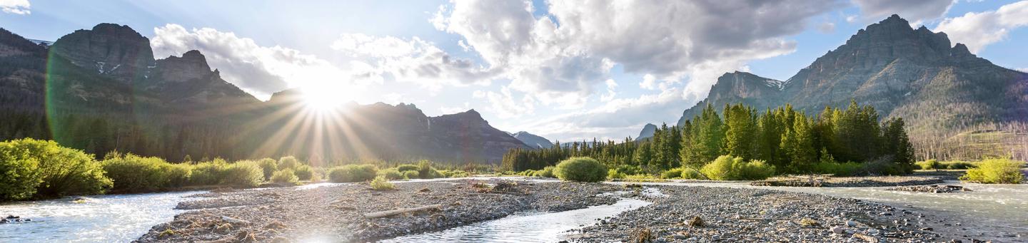
From expansive wilderness and back country areas that provide a refuge from everyday life, to campgrounds and picnic sites along travel corridors and in the front country, the Shoshone is a forest for recreation.
Serving as the eastern gateway to Yellowstone and Grand Teton National Parks, the Shoshone provides many opportunities for people to connect with nature.
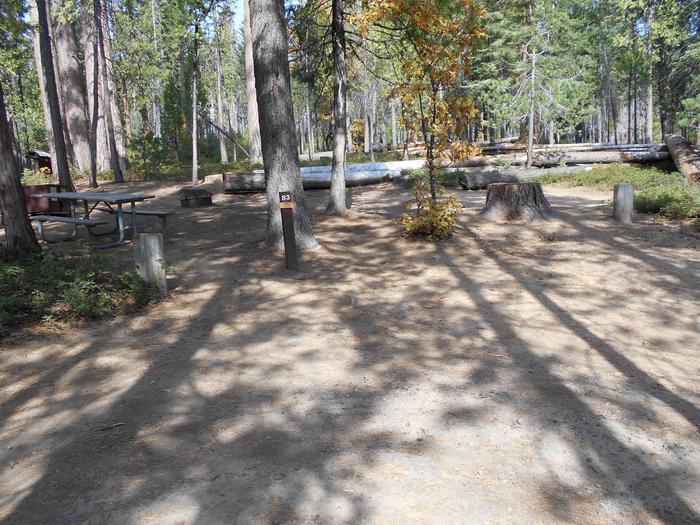
The Shoshone offers over 1,300 miles of trails, 32 campgrounds, and 11 picnic sites. Four Scenic Byways traverse the Shoshone, offering spectacular views of rugged mountain peaks, expansive plateaus awash in wildflowers, glaciers, rivers and streams, and unparalleled wildlife watching.
So, what are you waiting for? Pack up your family and friends and head for adventure in Wyoming’s great outdoors at Shoshone National Forest.

RecAreaDirections
Open with Google Map
Misc
| Stay Limit | |
| Reservable | false |
| Keywords | |
| Map Link | |
| Contact Phone | |
| Contact Email |
Permits info
Facilities
Shoshone National Forest Christmas Tree Permit Tree Permit
CLEARWATER CAMPGROUND Campground
List of CampsitesOverview
Clearwater Campground is located along the Buffalo Bill Scenic Byway, about 32 miles west of Cody, in northwestern Wyoming. It is 20 miles east of the east entrance to Yellowstone National Park. The surrounding area offers many outdoor recreational opportunities, including fishing, hiking and viewing local wildlife.Recreation
Great opportunities for hiking, fishing, scenic driving and wildlife viewing are available around the campground. The North Fork of the Shoshone River is a popular fly-fishing location for rainbow and Yellowstone cutthroat trout.Facilities
The campground offers one group camping area, which provides private parking, three large picnic tables, two food storage lockers and campfire circle.
Additionally, 11 single-family campsites are available on a first-come, first-served basis. Each campsite is equipped with a picnic table, campfire ring and food storage locker.
Vault toilets and trash collection are provided, but drinking water is not available. Campers may gather firewood from the area.
Natural Features
The campground is situated on the banks of the North Fork of the Shoshone River and has beautiful views of the surrounding mountains. Douglas fir and large juniper trees cover the campground, which sits at an elevation of 6,000 feet.A wide variety of wildlife lives in the area. Visitors often glimpse grizzly bears, deer, elk, bison, moose, fox, coyotes and bald eagles.
Nearby Attractions
Pahaska Tepee, west of the campground, is home to Buffalo Bill's original hunting lodge, built in 1904. Tours are offered daily between Memorial Day and Labor Day. Pahaska also offers guided horseback rides, a gift shop, restaurant and lodging.Yellowstone National Park's east entrance is 25 miles from the campground via the Buffalo Bill Cody Scenic Byway. The park offers unparalleled wildlife viewing opportunities, as well as breathtaking scenery and unique geological features.
The small, historic city of Cody offers a variety of dining, lodging and shopping options. The Buffalo Bill Historical Center offers extensive displays of Greater Yellowstone natural history, Plains Indians artifacts, western art, firearms, Buffalo Bill memorabilia and a wild sheep exhibit.
THREEMILE CAMPGROUND Campground
List of CampsitesOverview
Threemile Campground is located just three miles from the east entrance of Yellowstone National Park, and 50 miles from the full service gateway community of Cody, in northwestern Wyoming. The area is an ideal destination for a family getaway, with many opportunities for outdoor recreation. Hard-sided camp trailers and RVs are required.Recreation
Great opportunities for hiking, fishing, scenic driving and wildlife viewing are available around the campground. The North Fork of the Shoshone River is a popular fly-fishing location for rainbow and Yellowstone cutthroat trout. The nearby Pahaska Trail provides access into the North Absaroka Wilderness Area.Facilities
The campground offers family campsites for hard-sided camp trailers and RVs. Some sites overlook the river. Each site is equipped with a table, campfire ring and food storage locker. Vault toilets, hand-pumped drinking water (two spigots, one spigot is accessibiliy compliant) and trash collection are provided. Campers may gather firewood in the area.Natural Features
The campground is situated along the North Fork of the Shoshone River and has beautiful views of the surrounding mountains. A forest of lodgepole pine covers the campground, which sits at an elevation of 6,700 feet.A wide variety of wildlife lives in the area. Visitors often glimpse grizzly bears, deer, elk, bison, moose, fox, coyotes and bald eagles.
Nearby Attractions
Pahaska Tepee is just a mile west of the campground. This historic site is home to Buffalo Bill's original hunting lodge, built in 1904. Tours are offered daily between Memorial Day and Labor Day. Pahaska also offers guided horseback rides, a gift shop, restaurant and lodging.Yellowstone National Park's east entrance is three miles from the campground via the Buffalo Bill Cody Scenic Byway. The park offers unparalleled wildlife viewing opportunities, as well as breathtaking scenery and unique geological features.
The small, historic city of Cody offers a variety of dining, lodging and shopping options. The Buffalo Bill Historical Center offers extensive displays of Greater Yellowstone natural history, Plains Indians artifacts, western art, firearms, Buffalo Bill memorabilia and a wild sheep exhibit.
REX HALE Campground
List of CampsitesOverview
Rex Hale Campground is located along the Buffalo Bill Scenic Byway about 36 miles west of Cody, in northwestern Wyoming. It is just over 16 miles east of Yellowstone National Park's east entrance. The surrounding area offers many outdoor recreational opportunities, including fishing, hiking and viewing local wildlife.The campground is named after Rex Hale, one of 15 firefighters who died in the 1937 Blackwater Fire, which burned more than 1,700 acres of Forest Service lands within the Shoshone National Forest.
Recreation
Great opportunities for hiking, fishing, scenic driving and wildlife viewing are available around the campground. The North Fork of the Shoshone River is a popular fly-fishing location for rainbow and Yellowstone cutthroat trout.A firefighter memorial is located along the highway, just over a mile west of the campground. Forest Service Trail 758 leads to two additional memorials, which mark the locations where other firefighters lost their lives in the Blackwater Fire.
Mummy Cave is less than a mile from the campground. This historical site was discovered in 1957 and found to have been occupied for a period of over 9,000 years. Many artifacts, including a mummified ancient inhabitant, were excavated from the large alcove, which was placed on the National Register of Historic Places in 1981.
Facilities
The campground offers several campsites, some of which have electric hookups. Each site is equipped with a table, campfire ring and food storage locker. Potable water, vault toilets, and trash collection are provided. Campers are allowed to gather firewood in the area.
Natural Features
The campground is situated near the banks of the North Fork of the Shoshone River and offers views of spectacular red cliffs, where bighorn sheep may be seen early in the season.A wide variety of wildlife lives in the surrounding area. Visitors often glimpse grizzly bears, deer, elk, bison, moose, fox, coyotes and bald eagles.
Nearby Attractions
Pahaska Tepee, west of the campground, is home to Buffalo Bill's original hunting lodge, built in 1904. Tours are offered daily between Memorial Day and Labor Day. Pahaska also offers guided horseback rides, a gift shop, restaurant and lodging.Yellowstone National Park's east entrance is 18 miles from the campground via the Buffalo Bill Cody Scenic Byway. The park offers unparalleled wildlife viewing opportunities, as well as breathtaking scenery and unique geological features.
The small, historic city of Cody offers a variety of dining, lodging and shopping options. The Buffalo Bill Historical Center offers extensive displays of Greater Yellowstone natural history, Plains Indians artifacts, western art, firearms, Buffalo Bill memorabilia and a wild sheep exhibit.
BIG GAME CAMPGROUND Campground
List of CampsitesOverview
Big Game Campground is located along the Buffalo Bill Scenic Byway about 29 miles west of Cody, in northwestern Wyoming. It is 23 miles east of the east entrance to Yellowstone National Park. The surrounding area offers many outdoor recreational opportunities, including fishing, hiking and viewing local wildlife.Recreation
Great opportunities for hiking, fishing, scenic driving and wildlife viewing are available around the campground. The North Fork of the Shoshone River is a popular fly-fishing location for rainbow and Yellowstone cutthroat trout.The Wapiti Wayside is less than a half-mile east of the campground, and offers interpretive information on bears and other local wildlife.
Facilities
The campground offers single-family campsites, each equipped with a table and campfire ring. Vault toilets and trash collection are provided. Campers are allowed to gather firewood in the area. There is no water available at the campground.Natural Features
The campground is situated among cottonwood and juniper trees, along the North Fork Shoshone River, at an elevation of 6,000 feet.A wide variety of wildlife lives in the surrounding area. Visitors often glimpse grizzly bears, deer, elk, bison, moose, fox, coyotes and bald eagles.
Nearby Attractions
Pahaska Tepee, west of the campground, is home to Buffalo Bill's original hunting lodge, built in 1904. Tours are offered daily between Memorial Day and Labor Day. Pahaska also offers guided horseback rides, a gift shop, restaurant and lodging.Yellowstone National Park's east entrance is 23 miles from the campground via the Buffalo Bill Cody Scenic Byway. The park offers unparalleled wildlife viewing opportunities, as well as breathtaking scenery and unique geological features.
The small, historic city of Cody offers a variety of dining, lodging and shopping options. The Buffalo Bill Historical Center offers extensive displays of Greater Yellowstone natural history, Plains Indians artifacts, western art, firearms, Buffalo Bill memorabilia and a wild sheep exhibit.
HUNTER PEAK Campground
List of CampsitesOverview
Hunter Peak Campground is located on the Chief Joseph Scenic Highway/State Highway 296, approximately four miles south of the junction with scenic Beartooth Highway/U.S. Highway 12. The campground is about 60 miles northeast of Cody, in northwestern Wyoming.Recreation
The Clarks Fork offers outstanding fishing opportunities for rainbow and cutthroat trout. Many hiking trails are located in the area, including the Clarks Fork Trailhead, which is across the highway from the campground.Facilities
This small campground contains single-family campsites, each equipped with a table and campfire ring. Vault toilets, hand-pumped water, and trash collection are provided. A host is on-site. Firewood may be gathered in the area.
Fuel and sundries are available in the nearby community of Crandall.
Sites 5, 6, 7, and 8 are available for reservation. Please click on the "Check Availability" button for more information.
Natural Features
The campground sits on the banks of the Clarks Fork of the Yellowstone River, at an elevation of 6,500 feet. A mixed conifer forest covers the campground. A variety of wildlife, including grizzly bear, deer and elk makes its home in the area.Nearby Attractions
The Beartooth Highway was deemed "the most beautiful drive in America," by the late Charles Kuralt. It snakes across the rugged Beartooth Mountains from Red Lodge to Cooke City, Mont., and is the highest elevation highway in the Northern Rockies. Along the way, visitors are treated to sweeping views and plentiful outdoor recreation opportunities.Yellowstone National Park's northeast entrance is approximately 24 miles from the campground via the Beartooth Highway. The park offers unparalleled wildlife viewing opportunities, as well as breathtaking scenery and unique geological features.
WAPITI CAMPGROUND Campground
List of CampsitesOverview
Wapiti Campground is located is located along the Buffalo Bill Scenic Byway about 30 miles west of Cody, in northwestern Wyoming. It is 22 miles east of the east entrance to Yellowstone National Park. The surrounding area offers many outdoor recreational opportunities, including fishing, hiking and viewing local wildlife.Recreation
Great opportunities for hiking, fishing, scenic driving and wildlife viewing are available around the campground. The North Fork of the Shoshone River is a popular fly-fishing location for rainbow and Yellowstone cutthroat trout.The Wapiti Wayside is located less than a quarter-mile east of the campground and offers interpretive information on grizzly bears and other local wildlife.
Facilities
The campground offers accessible single- and double-family campsites, many of which have electric hookups. Sites 1 through 21 are standard RV Electric and have both 15 amp and 30 amp electrical hookups, and sites 22 through 40 are Standard Nonelectric. Each site is equipped with a table, campfire ring and food storage locker. Vault toilets, drinking water and trash collection are provided. Campers may gather firewood in the area.
Natural Features
The campground is situated among cottonwood and juniper trees, along the North Fork of the Shoshone River, at an elevation of 6,000 feet. Ancient cliffs from the Absaroka volcanic mud flow tower above the campground.A wide variety of wildlife lives in the area. Visitors often glimpse grizzly bears, deer, elk, bison, moose, fox, coyotes and bald eagles.
Nearby Attractions
Pahaska Tepee, west of the campground, is home to Buffalo Bill's original hunting lodge, built in 1904. Tours are offered daily between Memorial Day and Labor Day. Pahaska also offers guided horseback rides, a gift shop, restaurant and lodging.Yellowstone National Park's east entrance is 22 miles from the campground via the Buffalo Bill Cody Scenic Byway. The park offers unparalleled wildlife viewing opportunities, as well as breathtaking scenery and unique geological features.
The small, historic city of Cody offers a variety of dining, lodging and shopping options. The Buffalo Bill Historical Center offers extensive displays of Greater Yellowstone natural history, Plains Indians artifacts, western art, firearms, Buffalo Bill memorabilia and a wild sheep exhibit.
SUNLIGHT RANGERS CABIN Campground
List of CampsitesOverview
Sunlight Rangers Cabin lies within the Sunlight Ranger Station, located approximately 40 miles northwest of Cody, Wyoming, in the Shoshone National Forest. Guests enjoy the area for its abundant trails for hiking, biking and off-road riding.Recreation
Sunlight Creek is a popular fly-fishing stream. Anglers cast for cutthroat, rainbow and brook trout. Fishing is good in July, after the high-water season.Hikers, mountain bikers and off-road enthusiasts will find several motorized and non-motorized trails in the surrounding area.
Facilities
The spacious, three-room log cabin can accommodate up to eight people. It has two queen beds and two sets of bunk beds. No linens, bedding or pillows are provided. The fully-equipped kitchen includes a stove, refrigerator, microwave, toaster, coffee pot, pots, pans, dishes and utensils. The dining room has seating for eight. A fireplace is located in the living room. A telephone is available FOR EMERGENCIES ONLY. An indoor bathroom is available. Guests must bring their own towels and toiletries.Natural Features
The cabin is situated in beautiful Sunlight Valley near Sunlight Creek. A scenic, grassy meadow surrounds the cabin, and a mixed conifer forest covers the mountainsides.Island Lake Campground Campground
List of CampsitesThis beautiful high mountain lake campground has 21 newly remodeled sites. There is always plenty to do at this campground; hiking, fishing, wildlife viewing, and beautiful wildflowers galore.
16-day stay limit
Water: Available
This site is not accessible to persons with mobility impairments.
No cell service
Notes: Maximum spur 32 feet. Boat ramp closed until winter ice clears.
Fish Your National Forests: This site can be accessed by Passenger Car; Fish available include: Trout; Types of fishing available include: Wade, Shore, Motorized boat, Float tube, Fly, Spin, Bait, Ice; Boat Launch available
Sunlight Creek Picnic Site Facility
The Sunlight Creek Picnic Site is located along State Highway 296, the Chief Joseph Scenic Highway. The site has picnic tables, fire rings, and a vault toilet. Water is not available.
Newton Creek Campground Campground
List of CampsitesThis campground hosts 31 sites near the Shoshone River. Nearby points of interest include Mummy Cave and a memorial to firefighters who died in the 1937 Blackwater Fire. There are two trails, one leading to a natural bridge and the other leading to the Firefighters Memorial.
16-day stay limit
Water: Available
This site is not accessible to persons with mobility impairments
No cell service
Notes: Hard-sided camping only. Due to grizzly bear activity, no tents or pop-up campers allowed. Maximum spur 40 feet.
Worthen Meadow Campground Campground
List of CampsitesWorthen Meadow Campground has 28 campsites on the shores of Worthen Meadow Resevoir. Trailheads at the campground accesses the Popo Agie Wilderness. No trailers over 24 feet. Amenities include potable water, three vault toilets, picnic tables, cook grates and boat ramp. Worthen Meadow Picnic Area is nearby.
Tie Hack Memorial Facility
Eagle Creek Trailhead Facility
Eagle Creek Trailhead is one of the more popular trailheads for horse use along the North Fork of the Shoshone River. Trails leading from this area can take you into the North Absaroka Wilderness.
Geocaching (Forest-wide) Facility
Geocaching
Geocaching is an activity where participants seek hidden containers, called caches, using a variety of methods and clues that may include GPS (global positioning system) or other navigational aids. A typical cache may include a memento or prize, or a logbook where the geocacher or locator enters the date the cache was found.
Location
Geocaching is generally permissible in the Shoshone National Forest. It is not allowed in designated wildernesses areas, national scenic areas, wild and scenic river corridors, along historic or scenic trails, national historic landmarks, pre-historic sites, recreation or administrative sites (for example, campgrounds and work centers). Geocaches must not interfere with government owned or authorized improvements (for example, with outfitter and guide campsites).
The Cache
Geocached items must be cached in a container certified by the Interagency Grizzly Bear Committee (IGBC) as bear-resistant. A list of certified containers can be found by using the term “IGBC Certified Bear-Resistant Products List” in an internet search engine, or by contacting the IGBC at (406) 329-3434. To avoid wildlife disturbance, geocaches must not contain any food or odiferous products.
Container size may not exceed 12”W x 12”H x 12”D. Clearly label the exterior of the container as a geocache to avoid any confusion or safety concerns. The container shall contain contact information of the responsible party, including name, address, and phone number.
Placement
When geocaching, do not damage natural resources. This includes soil disturbance/digging, damaging or removal of live vegetation, and damaging natural features. Avoid sensitive areas like wetlands or streams. Do not disturb or remove historical artifacts or features. Geocached containers must be completely hidden from view (for example, they can be concealed in a pile of stones or within a hollow log).
Use
When geocaching, motorized vehicle use and parking shall be in compliance with the Forest’s travel regulations and Motor Vehicle Use Maps. The party responsible for placement of the cache is also responsible for complying with these guidelines. Out-of-compliance caches will be removed and may result in criminal citation.
Various actions and events take place in the Forest which may result in geocaches becoming temporarily unavailable, or in the removal or destruction of geocaches (for example, grizzly bear trapping or relocation, timber projects, special use projects, wildfires, and prescribed fires). Geocachers are responsible knowing and adhering to all Forest closures, restrictions and requirements. The Forest is not responsible for the loss or destruction of geocaches.
Geocachers do not need a special use authorization provided they comply with this document and all other Forest Service regulations and policies. If you have any questions about geocaching, please call the Ranger District office nearest the area where you're planning geocaching activities.
Absaroka-Beartooth Wilderness: Shoshone Facility
The United States Congress designated the Absaroka-Beartooth Wilderness in 1978 and it now has a total of 943,648 acres. Spanning the Montana-Wyoming border on the Shoshone, Gallatin, and Custer National Forests, the Absaroka Beartooth Wilderness is the juncture of two mountain ranges (Beartooth and Absaroka) with differing geologic types.
The Absaroka Range (prounounced ab-ZORE-kuh, the Crow Indian word for crow) is of volcanic origin, while the Beartooth Range, named for a spike of rock resembling a bear's tooth, is granitic in formation.
The extremely rugged and picturesque topography contains hundreds of lakes, high-rolling plateaus, and deep, glacier-carved valleys. Granite Peak, Montana's highest point at 12,799 feet, is located near the Wyoming-Montana border. This area also is known for several grasshopper glaciers, glaciers containing millions of grasshoppers frozen in ice.
Please view the special regulations associated with Wilderness and always use Leave No Trace techniques to help keep this area wild, clean, and pristine.
- Wilderness.net: Absorka-Beartooth Wilderness.net web page
North Absaroka Wilderness Facility
North Absaroka Wilderness was designated by Congress in 1964 and now maintains 350,488 acres. This area is defined by rugged volcanic mountains dissected by numerous creeks forming huge drainages. This secluded and rough country contains large regions of nearly inaccessible terrain.
Summers are relatively dry yet during summer rainstorms, tons of erodible material turns waterways into frothing rivers of mud. Water comes off the slopes quickly, and flash floods and fast-flowing high water are hazards for the traveler.
Few lakes are within the area, but the streams contain cutthroat, brown, brook, and rainbow trout. Marmots and pikas thrive on numerous talus slopes. This region is also home to grizzly bears. Please educate yourself about special precautions necessary when in bear country. Big-game hunters come by the hundreds for bighorn sheep, elk, and moose during hunting season.
There about 200 miles of rough and minimally marked trails, and hikers run a high risk of getting lost or hurt. Trails are generally long, steep, and narrow and tend to follow drainages that offer few places to cross except at the headwaters. From easily accessible Pahaska Campground, a trail runs north along Crow Creek to meet other trails. Be aware that some trails travel far from water and that travelers can expect to encounter washouts, fallen trees, and loose rock on the trails.
A limited number of desirable campsites has led to the overuse of some areas. Please follow special regulations associated with Wilderness and always use Leave No Trace techniques to help keep these areas wild, clean, and pristine.
- Wilderness.net: North Absaroka Wilderness.net web page
Wilderness Facility
The Shoshone National Forest encompasses all or parts of five designated wilderness areas and three mountain ranges. These areas are wild and untamed. Day hikers, backpackers, horsepackers, anglers, photographers, and others can enjoy pristine lakes, tumbling waterfalls, slopes awash in wildflowers, glacier-carved valleys, and a plethora of wildlife.
The North Absaroka (pronounced ab-ZORE-kuh) Wilderness and the Absaroka-Beartooth Wilderness can be found in the northern part of the Shoshone National Forest, while the Popo Agie (pronounced puh-POE-zhuh), the Fitzpatrick, and the Washakie (pronounced WA-shu-kee) Wilderness areas are situated in the southern portion.
Please view the special regulations associated with Wilderness and always use Leave No Trace techniques to help keep these areas wild, clean, and pristine.
Wilderness areas within Shoshone National Forest:
- Absaroka-Beartooth Wilderness
- Fitzpatrick Wilderness
- North Absaroka Wilderness
- Popo Agie Wilderness
- Washakie Wilderness
Fitzpatrick Wilderness Facility
Fitzpatrick Wilderness was designated in 1976 and named for Tom Fitzpatrick, a mountain man and partner of Jim Bridger. The area now spans 198,525 acres of magnificent beauty in the Wind River Range. Carved by glaciers from granite and limestone rock, the area contains alpine meadows, numerous lakes, rock-covered plateaus, precipitous canyons, and meandering streams. The western border is the Continental Divide, shared with Bridger Wilderness. The eastern border is shared with the Wind River Indian Reservation.
Fitzpatrick Wilderness currently has 44 active glaciers. Gannett Peak, Wyoming's highest point, at 13,804 feet, is flanked by three of these glaciers. Several other peaks in this area also rise above 13,000 feet. One of the main routes enters the Wilderness from Trail Lake.
Please view the special regulations associated with Wilderness and always use Leave No Trace techniques to help keep this area wild, clean, and pristine.
- Wilderness.net: Fitzpatrick Wilderness.net webpage
Washakie Wilderness Facility
Designated in 1964 Washakie Wilderness was named in honor of Chief Washakie, a leader of the Shoshone tribe of Wyoming. The area now encompasses 704,274 acres in the southern Absaroka Mountains. Yellowstone National Park borders to the northwest, Teton Wilderness to the west, and the Wind River Indian Reservation to the southeast.
The land is characterized by deep, narrow valleys exposing volcanic strata. Broad, flat-topped mountains and plateaus separate canyons. This volcanic material, much of which is deposited in horizontal layers, is unstable and highly erodible, which results in steplike cliffs and buttes. These unusual geologic formations, along with petrified remains of forests and abundant wildlife, are the main attractions of the Washakie.
Elevations range from about 6,600 to 13,153 feet, with peaks exceeding 12,000 feet scattered throughout the Wilderness. Large portions of this land are rough and barren with sparse vegetation, and approximately half the area is forested.
The area is home to bobcats, coyotes, foxes, beavers, and numerous smaller furbearers, as well as bald eagles and peregrine falcons. Hunters come for elk, moose, bighorn sheep, mule deer, and black bears. Grizzly bears, wolves and mountain lions are numerous. Travelers should take appropriate precautions. Please educate yourself about special precautions necessary when in bear country.
There are several miles of trails available in the area. Snow may fall any day of the year in the higher country, and summer temperatures rarely rise above 80 degrees Fahrenheit. Be prepared for rain showers in late summer.
Please view the special regulations associated with Wilderness and always use Leave No Trace techniques to help keep these areas wild, clean, and pristine.
- Wilderness.net: Washakie Wilderness Wilderness.net web page
Popo Agie Wilderness Facility
The Popo Agie was designated by Congress in 1984 and now stretches over 101,870 acres of very rugged topography in the Wind River Range. Popo Agie (pronounced puh-POE-zha, meaning "beginning of the waters") Wilderness has high jagged peaks separating beautiful streams in deep, narrow valleys. Perennial snowfields dot the Continental Divide running through this area.
More than 20 summits reach above 12,000 feet in elevation with Wind River Peak, at 13,225 feet, being the highest. Over 300 lakes and ponds grace the area. The headwaters of the Middle Fork Popo Agie, North Fork of the Popo Agie, and South Fork Little Wind Rivers originate here. All are tributaries of the Wind River.
Rugged, picturesque formations such as the Cirque of the Towers and timberline attract climbers, photographers, backpackers, and horsepackers to this scenic and challenging area. Many miles of trails attract a relatively large number of visitors, which has led to resource-protecting restrictions on camping and travel.
Please follow special regulations associated with Wilderness and always use Leave No Trace techniques to help keep these areas wild, clean, and pristine.
- Wilderness.net: Popo Agie Wilderness.net web page
Pinnacles Campground Campground
List of CampsitesThis campground hosts 21 campsites with dramatic views near Brooks Lake. Angling and flyfishing opportunities are nearby, with a boat ramp at Brooks Lake. Fantastic geologic formations at Pinnacle Butte can be seen on the drive in to the campground.
Maximum spur 32 feet.
Picnic tables, fire rings, bear boxes, and garbage collection are available.
This site is not accessible to those with mobility impairments.
