
Angeles National Forest
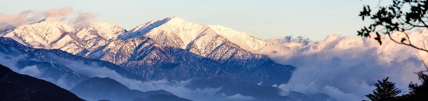
The Angeles National Forest was established by Executive Order in December 1892. It covers about 700,000 acres and is the backyard playground to the huge metropolitan area of Los Angeles. The Angeles manages the watersheds within its boundaries to provide valuable water to southern California and to protect surrounding communities from catastrophic floods.
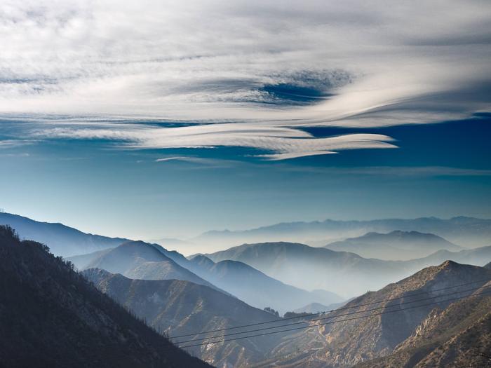
The land within the Forest is as diverse in appearance and terrain as it is in the opportunities it provides for enjoyment. Elevations range from 1,200 to 10,064 feet. Much of the Forest is covered with dense chaparral which changes to pine and fir-covered slopes as you reach the majestic peaks of the higher elevations.
The Angeles National Forest offers natural environments, spectacular scenery, developed campgrounds and picnic areas, swimming, fishing, skiing and the solitude of quiet wilderness areas. Trails winding throughout the forest accommodate hikers, equestrians, mountain bikers, and off-highway vehicle enthusiasts.
RecAreaDirections
Angeles National Forest 701 N. Santa Anita Ave. Arcadia, CA 91006 (626) 574-1613 M-F 8 a.m. - 4:30 p.m Closed for lunch between 1:00 - 1:30 PM
Open with Google MapMisc
| Stay Limit | |
| Reservable | false |
| Keywords | |
| Map Link | |
| Contact Phone | |
| Contact Email |
Permits info
Facilities
San Gabriel Canyon OHV Area Vehicle Tickets Timed Entry
The San Gabriel Canyon Off-Highway Vehicle Area is located 11 miles north of Azusa on Highway 39. Over 160 acres of rocky, sandy river bottom await users of two, three and four-wheeled off-highway vehicles (OHVs).
The OHV Area and obstacle course is open Saturdays, Sundays, and major holidays (New Year's Day, Memorial Day, Fourth of July, and Labor Day) at 8 a.m. All visitors must exit by 4:30 p.m. Special closures may occur if unusually high water, wildfire or capacity crowds occur.
Access into the San Gabriel Canyon OHV Area is through the Staging Area located along Highway 39. Parking and restrooms are provided. Food service is available at Camp Williams in the East Fork of San Gabriel Canyon. The nearest towing and gas services are located in the city of Azusa.
San Gabriel Canyon OHV Area has implemented a timed ticket reservation system in order to better manage high visitation demand. Tickets are issued per vehicle. Two types of tickets are available, Primary Vehicle, and Secondary Vehicle. A Primary Vehicle is any vehicle driven into the OHV area under its own power. A secondary vehicle is any vehicle trailered or hauled into the OHV area by a primary vehicle. Secondary vehicle tickets are only valid when purchased in conjunction with a primary vehicle ticket purchase.
PLEASE PRINT OR SCREENSHOT YOUR PURCHASED TICKET BEFORE YOU LEAVE HOME. THERE IS NO CELL PHONE SERVICE AVAILABLE AT THE SAN GABRIEL CANYON OHV AREA.
The full list of regulations and more information can be found at the following link San Gabriel Canyon OHV Area webpage .
CRYSTAL LAKE Campground
List of CampsitesOverview
Crystal Lake is open, however, campsites are no longer available for reservation on Recreation.gov. Campsites are available on a first-come, first-served basis. Located near the lake at the Crystal Lake Recreation Area and San Gabriel Canyon at an elevation of 5,600 feet. The climate is nice. Areas for tents are provided. Motorized boats are not allowed on the lake.PYRAMID LAKE - LOS ALAMOS CAMPGROUND Campground
List of CampsitesOverview
Los Alamos Campground is located 90 minutes from Los Angeles, offering a restful experience without the lengthy travel time. Guests enjoy the beauty of the nearby Pyramid Lake at the base of mountains, and the excitement of lake activities like jet skiing and wakeboarding. Water in Pyramid Lake takes a long journey from Plumas National Forest and Oroville Dam in northern California. An aqueduct carries the water down through the Tehachapi Mountains to its southern California resting point at Pyramid Lake.Recreation
Visitors can view lovely wildflowers and watch for birds. Jogging, mountain biking and motorcycle riding are enjoyable activities in the area. Various festivals take place at the lake throughout the year.Anglers can find striped, large, and smallmouth bass, rainbow trout, crappie and bluegill in Pyramid Lake. Boating and jet skiing are a big draw.
Facilities
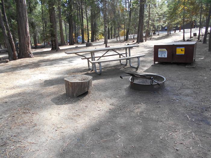
The campground offers 90 single family sites and 3 group campsites. Each group site fits 40 guests and 10 vehicles.Volleyball courts are provided for extra camping entertainment and the area has flush toilets and fresh drinking water. Sites come with picnic tables and grills. Some parking aprons are paved, but most are sandy gravel.
A dump station is available and a camp general store is also on-site. Campers here have first priority to enter Pyramid Lake, but it is recommended they arrive in line at the marina no later than 6:15 a.m.
Natural Features
Campsites are set back away from Pyramid Lake in the hills above the Santa Clarita Valley. The campsites are mostly open, but some trees offer limited shade to campers in Loop 3.Pyramid Lake spans 1,300 acres with 21 miles of shoreline. Pyramid Rock, the lake's namesake, is south of the lake's dam in Piru Gorge.
A diverse variety of animal life exists in Angeles National Forest. Birds and squirrels are commonly seen. Other wildlife includes bobcat, mountain lion, bear and Nelson bighorn sheep.
Nearby Attractions
The Vista Del Lago Visitor Center offers sweeping views of Pyramid Lake on its wraparound viewing platform. It also provides a giant map room with intriguing facts about California's geology and water supply systems.The Hungry Valley Off-Road State Vehicular Recreation Area is just minutes away, offering opportunities for off-road vehicle riding.
PYRAMID LAKE - EMIGRANT LANDING DAY USE AREA Campground
List of CampsitesOverview
This facility does not accept reservations. Emigrant Landing is the largest day use recreation area on beautiful Pyramid Lake. Located just 90 minutes from Los Angeles, it is the perfect getaway without the long drive. Visitors enjoy all the lake has to offer, from boating, water skiing, wakeboarding, and fishing. A large sandy swim beach attracts hours of play. Large trees and shelters provide cooling shade. Water in Pyramid Lake takes a long journey from Plumas National Forest and Oroville Dam in northern California. An aqueduct carries the water down through the Tehachapi Mountains to its southern California resting point at Pyramid Lake.Recreation
Visitors come here to picnic and spend hours fishing, boating, water skiing and jet skiing. Anglers seek striped, large, and smallmouth bass, rainbow trout, crappie and bluegill.Facilities
An accessible fishing pier, boat ramp, picnic tables and flush toilets are on-site. Drinking water and a soda machine are on hand for refreshment from the hot sun.Natural Features
The day use area sits on the northern end of Pyramid Lake in the sweeping hills above the Santa Clarita Valley. Pyramid Lake spans 1,300 acres with 21 miles of shoreline. Pyramid Rock, the lake's namesake, is south of the lake's dam in Piru Gorge.Nearby Attractions
The Vista Del Lago Visitor Center offers views of Pyramid Lake on its wraparound viewing platform. It also provides a giant map room with intriguing facts about California's geology and water supply systems.MEADOW GROUP CAMPGROUND Campground
List of CampsitesOverview
Meadow Group Campground is located off State Highway 2 between the Manzanita Loop of the Chilao Campground and the Chilao Ranger Station, 26 miles north of the 210 Freeway in La Canada, California.The campground offers access to a wide variety of recreational activities within the beautiful Angeles National Forest.
Recreation
This campground is 1.5 miles from the San Gabriel Wilderness- where hiking and equestrian use is permitted. In addition, there are also hiking, biking and equestrian trails nearby. The Chilao Visitor Center is located 1.5 miles east of the campground. It offers exhibits and information about the area, campfire programs and excellent bird watching opportunities, including ten species of woodpeckers.Facilities
The campground will accommodate two groups. Area 1 accommodates up to 24 people and has three picnic tables and fire rings, one water spigot, and an animal resistant dumpster. Area 2 can accommodate up to 80 people and has ten picnic tables and fire rings, two water spigots, a water fountain, and an animal resistant dumpster. Flush toilets are available, but are shared by both groups.Natural Features
The Meadow Group Campground is located within the San Gabriel Mountains National Monument, which is bordered by the Los Angeles Basin on the south, the San Gabriel Wilderness Area on the east, the San Gabriel Mountains on the north, and the junction of Interstate 5 and Highway 14 on the west. The campground is at an elevation of 5,300 feet amid Coulter pines, scrub oaks and grasslands. Visitors might see birds and squirrels along the nature trails, and the area is particularly known for its variety of woodpeckers.Nearby Attractions
State Route 2, the Angeles Crest Scenic Byway, is a National Forest Scenic Highway. The highway, as it winds along the San Gabriel Mountains, offers spectacular views of nearby peaks and valleys.Several vista points along the road offer the traveler expansive views of the Mojave Desert, the San Gabriel Mountains, and the San Gabriel and Pomona Valleys.
Charges & Cancellations
Booking Window
For most locations, you can reserve 12 months in advance for group sites. There are some exceptions, so it is best to check with each facility.
Change and Cancellation Policies and Fees
Camping: A $10.00 service fee will apply if you change or cancel your reservation. The $10.00 service fee will be deducted from the refund amount.
You can cancel or change reservations through Recreation.gov or by calling 1-877-444-6777.
Late Cancellations
Group Facility: If a customer cancels a group overnight facility reservation within 14 days of the scheduled arrival date they will be charged the $10.00 service fee and forfeit the first night's use fee. Cancellations for a single night's use will not be assessed a service fee.
No-Shows
Camping: A camping no-show customer is one who does not arrive at a campground and does not cancel the reservation by check-out time on the day after the scheduled arrival date. Reserved campsites and group overnight facilities will be held until check-out time on the day following your scheduled arrival.
If a customer does not arrive at the campground or group facility by check-out time the day after arrival or does not cancel the reservation by the times listed under "Late Cancellations" above, the customer may be assessed a $20.00 service fee and forfeit use fees.
Refunds
Customers must request refunds no later than 14 days after the scheduled departure date. Recreation.gov will not grant refund requests after 14 days of departure.
Reservation Fee: The reservation fee is not refundable if reservation is canceled within 14 days of arrival.
Refunds for Bankcard Purchases: Refunds for bank card payments will be issued as a credit to the original bank card.
Refunds for Check or Cash Purchases: Refunds for Recreation.gov payments made by check or money order, and cash payments at selected campgrounds will be issued a check refund. A refund will be processed within 30 days of receipt and approval. Please Note: Refund requests made during or after departure can only be processed when approved by the facility management staff based upon local policy.
Refunds for Emergency Closures: In the event of an emergency closure, the Recreation.gov team will attempt to notify users and offer alternate dates (as appropriate). If this is not possible, reservations will be cancelled and all fees paid will be refunded. Reservation fees for free tickets are non-refundable in the event of an emergency closure.
Recreation.gov Billing Information
Reservation transaction will appear on customer's credit card statements as "Recreation.gov 877-444-6777."
Changes to Policies and Procedures
Recreation.gov reserves the right, when necessary, to modify reservation policies. These policies were last updated July
JACKSON FLATS Campground
List of CampsitesOverview
Jackson Flats is a group camping facility located next to beautiful Grassy Hollow Visitor Center, which holds numerous nature programs, hikes and activities on Saturdays during the summer. The peaceful setting, in the Angeles National Forest, is a short drive northeast of the bustling Los Angeles metropolitan area.Recreation
Campers can enjoy hiking, biking and relaxing in the shade. A few short trails loop around the campground and a connector trail leads to the Pacific Crest Trail. The trail stretches from Mexico through California, Oregon and Washington.Additionally, the Angeles National Forest boasts 557 miles of hiking and equestrian trails. All trails, excluding the Pacific Crest Trail, allow mountain biking as well.
Facilities
Each tent-only site is located about 600 feet from the centrally-located parking area near the campground entrance. Campers may drive into the campsites only to unload/load their gear to their site. Vehicles may not park in campsites.
Each site is equipped with large picnic tables, a campfire circle, grills and bear-proof food storage lockers. There is no drinking water on site. Please bring all the drinking water you will need for your stay.
Natural Features
At an elevation 7,500 feet, Jackson Flats sits in grassy spaces among groves of pine and fir trees, with average summer daytime temperatures in the low 80s. Nights are cool.In Angeles National Forest, vegetation ranges from chaparral and oak at lower elevations to pine forests at higher altitudes. Elevations range from 1,200 to 10,000 feet.
The endangered California condor inhabits the forest. The Least Bells vireo and the Southwestern Willow flycatcher are two migratory birds that visitors enjoy spotting in the area. Other local inhabitants include the Arroyo toad, mountain yellow-legged frog, the mountain lion and the two-striped garter snake.
Nearby Attractions
- The Angeles Crest Highway, part of California State Route 2, is a scenic byway that meanders through oak thickets, chaparral, high desert landscapes and pine tree forests.
- The ski resort town of Wrightwood is very close by. Restaurants and a disc golf course can be found at the North Resort.
- Take a hike on the Blue Ridge Trail or the Pacific Crest Trail. The Pacific Crest Trail is an impressive path that starts in Mexico and zigzags its way through Angeles and continues north across California, Oregon and Washington.
MOUNTAIN OAK Campground
List of CampsitesOverview
Escape to Mountain Oak Campground in the Angeles National Forest for a restful, refreshing getaway from city life. Just northwest of the Los Angeles metro area, Mountain Oak provides a scenic and relaxing destination for camping, hiking, picnicking and wildlife viewing.The campground is also near Jackson Lake for easy access to fishing, canoeing and swimming.
Recreation
Swim or canoe in the refreshing waters of Jackson Lake, the only lake near Wrightwood. The lake is stocked with trout and bluegills. Powerboating is not permitted in the lake, so the setting is peaceful and quiet.Hikers can find trails near the campground.
Facilities
The single-loop campground provides lots of shade from towering trees but minimal privacy from neighboring campgrounds. Ground cover is mostly pine needles and leaves.Bear-proof food containers are provided at each campground and amenities include picnic table, grills and flush toilets. Drinking water is also available.
A camp host is on-site, offering firewood for sale.
Natural Features
At an elevation of 6,400 feet, Mountain Oak is shaded by oak, ponderosa and sugar pines in the Angeles National Forest. This forest, spanning across most of the San Gabriel Mountains, provides a striking backdrop for the Los Angeles area.Jackson Lake spans just 3 acres and lies in the San Gabriel Mountains. Formed by the San Andreas fault, the lake is primarily fed by snow runoff from the mountains and is hugged by grass and sand beaches. The lake is ideal for listening to nature's soundtrack, complete with sounds of birds singing and leaves rustling in mountain breezes.
A diverse variety of animal life exists in Angeles National Forest, such as bobcat, mountain lion, bear and Nelson bighorn sheep. Many species of birds and smaller animals also inhabit the forest.
Nearby Attractions
- The Angeles Crest Highway, part of California State Route 2, is a scenic byway that meanders through oak thickets, chaparral, high desert landscapes and pine tree forests.
- The ski resort town of Wrightwood is very close by. Restaurants and a disc golf course can be found at the North Resort.
- Take a hike on the Blue Ridge Trail or the Pacific Crest Trail. The Pacific Crest Trail is an impressive path that starts in Mexico and zigzags its way through Angeles and continues north across California, Oregon and Washington.
LAKE CAMPGROUND Campground
List of CampsitesOverview
Lake Campground offers an excellent escape from the city, just a short drive northeast of the Los Angeles metro area. It's set on the shores of Jackson Lake, providing a scenic, peaceful setting for fishing, swimming and canoeing in Angeles National Forest.Visitors enjoy exploring the Angeles Crest Scenic Byway, which offers incredible views of oak thickets, high desert landscapes, chaparral and pine forests.
Recreation
Wildlife viewing is a popular activity, as visitors may see bobcats, mountain lions, bears and Nelson bighorn sheep.Powerboating is not permitted on Jackson Lake, so the setting is peaceful and quiet for swimming, canoeing and fishing. The lake is stocked with trout and bluegill.
Facilities
Campsites can accommodate eight campers and two vehicles. Food storage lockers, grills, picnic tables, vault toilets and drinking water are provided. Firewood can be purchased at nearby Mountain Oak Campground.Natural Features
Lake Campground sits at an elevation of 6,100 feet in Angeles National Forest. Campsites are secluded and shaded with scattered oak trees and Jeffrey pines. Daytime temperatures in the summer are usually in the low 80s and evenings are cool.Angeles National Forest spans nearly 695,000 acres over most of the San Gabriel Mountain Range in southern California. Vegetation ranges from chaparral and oak at lower elevations to pine forests at higher altitudes. Elevations range from 1,200 to 10,000 feet.
The endangered California condor inhabits the forest. The Least Bells vireo and the Southwestern Willow flycatcher are two migratory birds that visitors enjoy spotting in the area. Other local inhabitants include the Arroyo toad, mountain yellow-legged frog, the mountain lion and the two-striped garter snake.
Nearby Attractions
- The Angeles Crest Highway, part of California State Route 2, is a scenic byway that meanders through oak thickets, chaparral, high desert landscapes and pine tree forests.
- The ski resort town of Wrightwood is very close by. Restaurants and a disc golf course can be found at the North Resort.
- Take a hike on the Blue Ridge Trail or the Pacific Crest Trail. The Pacific Crest Trail is an impressive path that starts in Mexico and zigzags its way through Angeles and continues north across California, Oregon and Washington.
TABLE MOUNTAIN (ANGELES) Campground
List of CampsitesOverview
Table Mountain, just a short journey northwest of the Los Angeles metro area, provides a beautiful escape from urban life. Campers will find hiking, mountain biking, birding and countless other recreation opportunities. The surrounding landscape is also ideal for scenic drives.The campground sits in the Angeles National Forest, spanning 694,187 acres over most of the San Gabriel Mountain range. The forest boasts spectacular scenery and 557 miles of hiking and equestrian trails.
Recreation
The Table Mountain Nature Trail runs through the campground, and visitors can spot birds, squirrel, deer and the California condor.The Angeles Crest Scenic Byway is a highly recommended drive that extends through oak thickets, chaparral, high desert landscapes and pine tree forests along the highest and most scenic ridges of the San Gabriel mountain range.
Facilities
Campsites range from level meadow locations to shaded, hilly sites. All sites are reasonably close to vault toilets and have paved spurs and fire pits. Water spigots are spaced about every six sites.
The amphitheater site is available for day-use only and accommodates up to 150 guests and 30 vehicles. Prices vary based on time of year. To RESERVE THE AMPHITHEATER contact Tyler Shippy at [email protected] or call (888) 754-7878 ext 7834.
Natural Features
Table Mountain is set in a hilly, oak and pine forest with two large meadows and beautiful views. At an elevation of 7,000 feet, summer temperatures average in the low 80s with cool nights.Nearby Attractions
- The Angeles Crest Highway, part of California State Route 2, is a scenic byway that meanders through oak thickets, chaparral, high desert landscapes and pine tree forests.
- The ski resort town of Wrightwood is very close by. Restaurants and a disc golf course can be found at the North Resort.
- Take a hike on the Blue Ridge Trail or the Pacific Crest Trail. The Pacific Crest Trail is an impressive path that starts in Mexico and zigzags its way through Angeles and continues north across California, Oregon and Washington.
contact_info
For facility specific information, please call (760) 316-7828.LIGHTNING POINT GROUP CAMPGROUND Campground
List of CampsitesOverview
Lightning Point Group Campground is closed until further notice. Lightning Point Campground is conveniently located 25 miles southeast of Palmdale and 35 miles north of the San Fernando Valley. The campground is nestled in a forest of Jeffrey pine, scrub oaks and manzanita and can accommodate both groups and equestrian campers. Hiking on the Pacific Crest National Scenic Trail is a favorite pastime for many campers. The trail, which is accessed nearby, weaves all the way from Canada to Mexico with views of six out of the seven ecozones found in North America.Recreation
Hiking, bird watching and horseback riding are the biggest attractions for campers. Angeles National Forest boasts 557 miles of hiking and equestrian trails. All trails, excluding the Pacific Crest Trail, allow mountain biking as well.Facilities
The peaceful campground has six group campsites that can accommodate a total of 240 campers. Two of the sites are designed for horse camping.Sites 5 and 6 have six horse corrals each, but horses are not required to reserve these sites.
All sites have group-sized tables. Added features include horse corrals, large gathering areas, and a short and easy nature trail.
No toilets or water is available. Visitors must bring their own portable toilets and take all components with them upon departure.
Natural Features
At 6,100 feet elevation, the area receives average summer temperatures in the low 80s with cool nights.In Angeles National Forest, vegetation ranges from chaparral and oak at lower elevations to pine at higher altitudes. Elevation ranges from 1,200 to 10,000 feet of low canyons and tall mountain peaks.
Nearby Attractions
Hop in the car and drive along the Angeles Crest Highway, a scenic byway that meanders through oak thickets, chaparral, high desert landscapes and pine tree forests.COULTER GROUP CAMPGROUND Campground
List of CampsitesOverview
At Coulter Group Campground groups can relax and enjoy the experience of being outdoors without traveling far from the greater Los Angeles metropolitan area. The Angeles Crest Highway, a scenic byway that meanders through oak thickets, chaparral, high desert landscapes and pine tree forests is located nearby.Recreation
Visitors can explore the Silver Moccasin Trail, open to hiking, horseback riding and mountain biking. The 58-mile trail accesses the extensive Pacific Crest Trail, which stretches from Mexico to Canada.Facilities
The campground has four group picnic tables, a vault toilet, stoves, a group campfire ring and a water spigot. The maximum RV length is 40 feet.Natural Features
The campground sits at an elevation of 5,300 feet, less than a mile from the San Gabriel Wilderness. Over 36,000 acres within the Angeles National Forest are designated as the San Gabriel Wilderness Area and have been set aside to preserve their wilderness character.The area encompasses some extremely rugged terrain, ranging in elevation from 1,600 to 8,200 feet. The lower elevations are covered with dense chaparral which rapidly changes to pine and fir-covered slopes and majestic peaks with glimpses of wildflowers and a variety of wildlife as you enter the upper elevations.
Nearby Attractions
Visit the Chilao Visitor Center, just 1.5 miles east of the campground. The center provides exhibits and interesting information about the region and excellent bird watching opportunities. Visitors can learn about the 10 species of woodpeckers in the area.Charges & Cancellations
Booking Window
For most locations, you can reserve 12 months in advance for group sites. There are some exceptions, so it is best to check with each facility.
Change and Cancellation Policies and Fees
Camping: A $10.00 service fee will apply if you change or cancel your reservation. The $10.00 service fee will be deducted from the refund amount.
You can cancel or change reservations through Recreation.gov or by calling 1-877-444-6777.
Late Cancellations
Group Facility: If a customer cancels a group overnight facility reservation within 14 days of the scheduled arrival date they will be charged the $10.00 service fee and forfeit the first night's use fee. Cancellations for a single night's use will not be assessed a service fee.
No-Shows
Camping: A camping no-show customer is one who does not arrive at a campground and does not cancel the reservation by check-out time on the day after the scheduled arrival date. Reserved campsites and group overnight facilities will be held until check-out time on the day following your scheduled arrival.
If a customer does not arrive at the campground or group facility by check-out time the day after arrival or does not cancel the reservation by the times listed under "Late Cancellations" above, the customer may be assessed a $20.00 service fee and forfeit use fees.
Refunds
Customers must request refunds no later than 14 days after the scheduled departure date. Recreation.gov will not grant refund requests after 14 days of departure.
Reservation Fee: The reservation fee is not refundable if reservation is canceled within 14 days of arrival.
Refunds for Bankcard Purchases: Refunds for bank card payments will be issued as a credit to the original bank card.
Refunds for Check or Cash Purchases: Refunds for Recreation.gov payments made by check or money order, and cash payments at selected campgrounds will be issued a check refund. A refund will be processed within 30 days of receipt and approval. Please Note: Refund requests made during or after departure can only be processed when approved by the facility management staff based upon local policy.
Refunds for Emergency Closures: In the event of an emergency closure, the Recreation.gov team will attempt to notify users and offer alternate dates (as appropriate). If this is not possible, reservations will be cancelled and all fees paid will be refunded. Reservation fees for free tickets are non-refundable in the event of an emergency closure.
Recreation.gov Billing Information
Reservation transaction will appear on customer's credit card statements as "Recreation.gov 877-444-6777."
Changes to Policies and Procedures
Recreation.gov reserves the right, when necessary, to modify reservation policies. These policies were last updated July
BANDIDO GROUP CAMPGROUND Campground
List of CampsitesOverview
Groups of all types will enjoy staying at the Bandido Group Campground, which boasts beautiful scenery in a relaxing, rustic atmosphere. The site accommodates groups of up to 150 campers, but is designed for equestrian campers and provides several horse corrals and hitch racks. Bandido is divided into five campsites, each with varying capacities for smaller groups. Site #1 has a capacity of 12 campers. Site #2 can accommodate 60 campers. Site #3 and #5 can each hold a maximum of 30 campers. Site #4 has a capacity of 18 campers.Recreation
Several trails for hiking, mountain biking and horseback riding can be accessed from the campground. This includes a connector trail to the Pacific Crest Trail (PCT). The PCT stretches from Mexico all the way north to Canada. Within the Angeles Forest, the impressive trail covers 176 miles of its lengthy journey.Facilities
No water or electricity is available. There are 25 picnic tables, community fire rings, vault toilets and 20 horse corrals. The site also boasts paved roads and space to park trailers.Natural Features
The campground sits at an elevation of 5,840 feet, surrounded by Jeffery pines, scrub oaks and manzanita. The Angeles National Forest spans 694,187 acres over most of the San Gabriel Mountain range in southern California. Elevations here range from 1,200 to 10,000 feet, from the low canyon lands to the snow-capped mountain peaks.Nearby Attractions
Drive the Angeles Crest Highway, a scenic byway that meanders through oak thickets, chaparral, high desert landscapes and pine tree forests.Charges & Cancellations
Booking Window
For most locations, you can reserve 12 months in advance for group sites. There are some exceptions, so it is best to check with each facility.
Change and Cancellation Policies and Fees
Camping: A $10.00 service fee will apply if you change or cancel your reservation. The $10.00 service fee will be deducted from the refund amount.
You can cancel or change reservations through Recreation.gov or by calling 1-877-444-6777.
Late Cancellations
Group Facility: If a customer cancels a group overnight facility reservation within 14 days of the scheduled arrival date they will be charged the $10.00 service fee and forfeit the first night's use fee. Cancellations for a single night's use will not be assessed a service fee.
No-Shows
Camping: A camping no-show customer is one who does not arrive at a campground and does not cancel the reservation by check-out time on the day after the scheduled arrival date. Reserved campsites and group overnight facilities will be held until check-out time on the day following your scheduled arrival.
If a customer does not arrive at the campground or group facility by check-out time the day after arrival or does not cancel the reservation by the times listed under "Late Cancellations" above, the customer may be assessed a $20.00 service fee and forfeit use fees.
Refunds
Customers must request refunds no later than 14 days after the scheduled departure date. Recreation.gov will not grant refund requests after 14 days of departure.
Reservation Fee: The reservation fee is not refundable if reservation is canceled within 14 days of arrival.
Refunds for Bankcard Purchases: Refunds for bank card payments will be issued as a credit to the original bank card.
Refunds for Check or Cash Purchases: Refunds for Recreation.gov payments made by check or money order, and cash payments at selected campgrounds will be issued a check refund. A refund will be processed within 30 days of receipt and approval. Please Note: Refund requests made during or after departure can only be processed when approved by the facility management staff based upon local policy.
Refunds for Emergency Closures: In the event of an emergency closure, the Recreation.gov team will attempt to notify users and offer alternate dates (as appropriate). If this is not possible, reservations will be cancelled and all fees paid will be refunded. Reservation fees for free tickets are non-refundable in the event of an emergency closure.
Recreation.gov Billing Information
Reservation transaction will appear on customer's credit card statements as "Recreation.gov 877-444-6777."
Changes to Policies and Procedures
Recreation.gov reserves the right, when necessary, to modify reservation policies. These policies were last updated July
Los Angeles Gateway District Facility
The Los Angeles Gateway District Office is located at 12371 N. Little Tujunga Canyon Road, Sylmar, CA 91342.
Jamahl Butler, District Ranger
Aaron Ash, Deputy District Ranger
(818) 899-1900
FAX (818) 896-6727
CRS (800) 735-2922 (Voice)
CRS (800) 735-2929 (TDD/TTY)
San Gabriel Mountains National Monument Facility
San Gabriel Mountains National Monument Office is located at 110 N. Wabash Ave., Glendora, CA 91741
(626) 335-1251, Ext. 221
CRS (800) 735-2922 (Voice)
CRS (800) 735-2929 (TDD/TTY)
FAX (626) 914-3790
Peavine Campground Campground
List of Campsites6.100-foot elevation. 4 tent sites. No water. Vault toilets. Adventure Pass required for vehicles parked at campground. First come - first served.
Usually inaccessable during the winter months. The area has heavy use during snow play.
Rocky Point Picnic Site Facility
Picnic Site
Sage Picnic Site Facility
Picnic Site
Southfork Campground Campground
List of CampsitesAt a Glance:
- 4,500-foot elevation
- 21 sites
- RV's up to 16'
- No water
- Vault toilets
- Campsites are first-come, first-served
What to Expect
South Fork Campground on the backside of the San Gabriel Mountains is a hidden gem in the Mojave Desert. Tucked in the middle of steep canyon walls descending from Mt. Islip from the South and Vazquez Rocks in the North, this campground offers 21 spacious sites of year-round tranquility. Each site comes with a fire-ring and grill to huddle around and cook those family campfire meals. Additionally, each site comes with a picnic bench should your group decide a game of cards is in order.
After an evening around the fire, the South Fork Campground offers hiking and horseback riding to some of the most beautiful features in the San Gabriels. Campers turned hikers can travel south along Big Rock Creek towards Islip Saddle and see seasonal waterfalls or spot a Nelson's Big Horn Ram. What's more, hikers can head east along the Manzanita Trail towards Vincent's Gap or west to the Devil's Punchbowl - one of the most geologically interesting places in Los Angeles County. Regardless of the time of the year, visitors can find a trail that suits their needs and experience level.
If hiking isn't your "thing," South Fork Campground delivers excellent snow play, fishing, and stargazing.
Streamside Campground Campground
List of CampsitesCampground
Upper Shake Campground Campground
List of CampsitesClosed Campground.
Zuni Campground Campground
List of CampsitesClosed.
Please call the Acton Work Center at (661) 269-2808 for information.
Coldbrook Campground Campground
List of CampsitesColdbrook Campground offers 22 shaded campsites* at the intersection of Coldbrook and Soldier Creeks that are open year round. Available on a first-come, first-serve basis, each campsite can fit up eight people and two vehicles (additional fee applies for the second vehicle). This campground is less populated then nearby Crystal Lake Recreation Area. However, it does reach capacity on most summer weekends. Each campsite has a fire pit and grill, and picnic tables are available on the grounds. Potable water is available on the campgrounds.
The trailhead for the 7-mile round trip hike to the summit of Smith Mountain is just 1/3 of a mile away and the popular Bridge to Nowhere hike is a short drive away. RV's are allowed up to 22 feet, but there are no hookups for electricity or waste.
*Note: Camping - $12 per night per site, $5 for extra vehicle. Day use - $5 per vehicle. Adventure Pass will be honored for day use. Campsites are first-come-first-served. Adventure Pass required for vehicles parked outside the campground. A California Campfire Permit is required.
Los Cantiles Group Picnic Site - Closed Facility
This site has experienced flood/fire damage and is currently undergoing rehabilitaion. Please contact the district office for more information.
Group Picnic Site
Icehouse Trailhead Facility
Trailhead
Rowher Flats Trailhead Facility
Trailhead
Heaton Flats Trailhead Facility
Trailhead. Parking along East Fork Road and in East Fork Road parking lot.
Islip Wawona Trailhead Facility
Trailhead
Strawberry Colby Trailhead Facility
Trailhead
Windy Gap Trailhead Facility
Trailhead
Echo Mountain Picnic Site Facility
Picnic Site. Day use hours are 6 am to 10 pm.
Nino Picnic Site Facility
Picnic Site
Paul Little Picnic Site Facility
Picnic Site
The Pines Picnic Site - Closed Facility
Picnic Site
Chantry Flat Picnic Site Facility
At a Glance:
Location: Arcadia, CA
Use: Heavy
Pets Allowed: Yes, but must remain on a leash 6-foot or shorter
Fee: Adventure Pass must be displayed in the parking lot
Amenities: picnic tables; toilets, accessible sites
What to Expect
Nestled high on a ridge in Big Santa Anita Canyon, Chantry Flat Picnic area offers a quick getaway to nature for those who seek it. To reach Chantry Flat Picnic area, a quick five-mile drive up Santa Anita Ave. in Arcadia, CA off Interstate 210 is all that required. The drive itself will deliver epic views of the San Gabriel Valley while passing jagged exposed before reaching the shade of Chantry Flat.
After parking and displaying an Adventure Pass, visitors have an array of activities to choose from. Whether its setting up a family picnic on one of the many picnic sites tucked into the hillside or choosing to hike to nearby Sturtevant or Hermit Falls, this area has a little something for everyone.
Because it has so much variety, it is one of the most popular sites in the Angeles National Forest, so it is advised to as much caution when parking or navigating the trails.
Charlton Flats Picnic Area Facility
5,200-foot elevation. Day use hours are 6 am to 10 pm. During the winter months, Charlton Flat may close at any time due to snow and/or ice. Please contact the San Gabriel Mountains National Monument- Acton Work Center at 661-269-2808 for the most current information.
Chilao Picnic Area Facility
There is currently no piped water available at Chilao Picnic Area. Please bring enough water for cooking, cleaning, drinking, and extinguishing campfires.
5300' elevation. Day use hours are 6 am to 10 pm. Please contact the San Gabriel Mountains National Monument- Acton Work Center at 661-269-2808 for the most current information.
Vista Picnic Area Facility
Picnic Area. Day use area hours are 6 am to 10 pm.
Eagles Roost Picnic Area Facility
Picnic Area. Day use hours are 6 am to 10 pm.
Clear Creek Information Station Facility
VIS Information Site/Fee Station
Contact the Los Angeles Gateway Ranger District at (818) 899-1900 for additional information.
Chilao Visitor Center Facility
For additional information on programs and activities available at the visitor center, please call 626-796-5541.
Three Points Trailhead Facility
Trailhead
Islip Saddle Day Use Area Facility
Trailhead and Day Use Area.
Devil's Canyon (Hwy 2) Trailhead Facility
Trailhead
Mt. Wilson Rd/Eaton Saddle Trailhead Facility
Trailhead
Inspiration Point Interpretive Site Facility
Interpretive Site
Buckhorn Day Use Area Facility
Day use area hours are 6 am to 10 pm.
Arch Picnic Site Facility
Picnic Site
Big Pines Visitor Center Interpretive Site Facility
Visitor Center - Heavy use during snow play. There are 3 picnic tables and several benches close to the restroom at the site.
For additional information, contact the San Gabriel Mountains National Monument office at (661) 269-2808 or call the center at (760) 249-3504.
Fisherman's Point Fishing Site Facility
Fishing Point
Inspiration Point Trailhead Facility
Trailhead - this site has a view of Mt. Baldy and San Gabriel Canyon. There is a vault toilet, pct trail access, and available equestrian parking.
Jackson Lake Picnic Site Facility
Picnic Site
Juniper Picnic Site Facility
PIcnic Site
Mescal Picnic Site Facility
Picnic Site
Heavy use during snow play.
Table Mountain Picnic Site Facility
Picnic Site
Valyermo Picnic Site - Closed Facility
Picnic Site
Mt. Baden Powell via Vincent's Gap Facility
At a Glance:
Distance: 8 miles (one-way)
Difficulty: Medium
Total Climbing: 2,765 feet
Highest Elevation: 9,356 feet
What to Expect
What to Expect
This iconic Southern California hike intersects with two nationally recognized trails, the Pacific Crest Trail and the Silver Moccasin trail as it winds its way up towards the summit of Mt. Baden-Powell.
The trail is the most difficult route to the summit but is the most popular way to reach the top. This 8-mile trek features 35 switchbacks up the north face of one of the tallest mountains in the San Gabriels. Those attempting this "must-do" hike will find the beginning part of the hike the most difficult with the rest being slightly easier. The trail will take backpackers under the spine of the ridge through stands of Jeffrey, Ponderosa, and Lodgepole pines. What's more, be sure to stop and admire the 1,500-year-old Limber pine at the timberline.
Fun fact: Mt. Baden-Powell is named after Lord Robert Baden-Powell in 1931. He was the founder of the modern Boy Scouts and as such the trail is well-maintained by Boy Scout groups. A monument lies in his honor near the summit of his named mountain.
Lake Elizabeth Picnic Site Facility
Picnic Site. Day use hours are 6 am to 10 pm.
Serrano Picnic Site Facility
Picnic Site
Spanish Point Picnic Site Facility
Picnic Site
Vista Del Lago Interpretive Site (major) Facility
Intrepretive Site
Yellowbar Picnic Site Facility
Picnic Site
Beartrap Picnic Site Facility
Picnic Site
Green Valley Station Interpretive Site (admin) Facility
Interpretive Site
Bear Divide Vista Picnic Site Facility
Picnic Site. Day use hours are 6 am to 10 pm.
Hidden Springs Picnic Site Facility
Picnic Site. Day use hours are 6 am to 10 pm.
Mill Creek Summit Picnic Area Facility
Picnic Area.
Stonyvale Picnic Site Facility
Picnic Site. Day use hours are 6 am to 10 pm.
Vogel Flat Picnic Site Facility
Picnic Site
Wildwood Picnic Site Facility
Picnic Site. Day use hours are 6 am to 10 pm.
North Fork Saddle Picnic Site-No Vehicle Access Facility
Picnic Site. Day use hours are 6 am to 10 pm.
PCT Pony Park Trailhead Facility
5000' elevation. Trailhead for the Pacific Crest Trail.
Trail Canyon Trailhead Facility
Trailhead
Mt. Baldy Visitor Center Interpretive Site (major) Facility
For additional information on programs and activities available at the visitor center, follow this link.
For more information call (909) 982-2829 or contact the San Gabriel Mountains National Monument at (626) 335-1251.
Mt. Baldy Wayside Picnic Site Facility
Picnic Site
Oaks Picnic Site Facility
Picnic Site
West Fork Day Use Trailhead Facility
At a Glance:
Distance: 7 miles (one-way)
Difficulty: Easy
Total Climbing: Minimal
What to Expect
For those seeking an easy stroll down a canopied paved trail with relaxing water sounds, then the West Fork is for you! This 7-mile hike is located 14-miles above the city of Azusa, CA on Highway 39. This nationally designated bikeway is very popular with bicyclists who enjoy flat surface as they make their way towards Glenn Campground and eventually Cogswell damn.
During a hot-summer-day, hikers can cool off by dipping into the West Fork of the San Gabriel River under shade from Sycamore, White alder, and Willow trees.
It's important to note, however, this is one of the forest's more popular hikes and the nearby West Fork parking lot only accommodates 45 vehicles (make sure to display an Adventure Pass) so it's recommended to come very early in the morning or later in the afternoon to avoid the crowds.
West Fork Fishing Access Fishing Site Facility
Fishing Access

.
San Gabriel Cyn OHV Area Specialized Sport Site Facility
The San Gabriel Canyon Off-Highway Vehicle Area (Brochure) is located 11 miles north of Azusa on Highway 39. Over 160 acres of rocky, sandy river bottom await users of 2, 3 and 4-wheeled OHVs.
Vacquero Boating and Picnic Site Facility
Boating Site
Shortcut Saddle Trailhead Facility
Trailhead for the Silver Moccassin Trail
Vetter Mountain Lookout Interp Site Facility
Interpetive Site
East Fork Day Use Pking Trailhead Facility
Trailhead. Limited Parking.
San Gabriel Cyn Entry Sta Info Site/fee Station Facility
Information Site
Red Box Picnic Area Facility
Picnic Site. Day use hours are 6 am to 10 pm.
San Gabriel Environmental Education Center Interpr Facility
Intrepretive Site
Delta Flat Day Use Site Facility
Closed.
Colby Bridge Day Use Area Facility
Day use hours are 6 am to 10 pm.
Fawnskin Picnic Area Facility
Open for Day Use at Fawnskin Picnic Area. Camping is available in Loops A, B and C (36 sites). During winter months, campsite access is walk-in only and drive-in during the summer. CRYSTAL LAKE VISITOR CENTER Staffed by Angeles Volunteer Association (626) 910-1149 Hours of Operation: Saturday and Sunday - 8:00am to 4:00pm
Frenchman's Flat Day Use Area Facility
The 2,200-acre Frenchman’s Flat standard amenity recreation fee area is a popular riparian area most well-known for the Wild and Scenic River designation, and its native trout fishery. Recreation activities include wildlife viewing, swimming, hiking, and picnicking. Day use hours are 6 am to 10 pm.
Lower San Antonio Day Use Facility
Located near Mt. San Antonio aka Mt. Baldy, this picnic area offers visitors a chance enjoy the great outdoors underneath the tallest peak in the Angeles National Forest - San Gabriel Mountains National Monument
Sawmill Campground Campground
List of Campsites5200-foot elevation. 8 sites. No water. Vault toilets. Campsites are first come - first served. RV's to 16'.
Must access this campground from Pine Canyon Road due to washout on 7N23. Can not access from Old Ridge Route.
Please call the Acton Work Center at (661) 269-2808 for information.
Grassy Hollow Picnic Site Facility
Picnic Site
Grassy Hollow Visitor Center Interpretive Site Facility
For additional information on programs and activities available at the visitor center, follow the link.
For additional information contact the Santa Clara/Mojave Rivers Ranger District Office at (661) 296-9710 or contact the center directly at (626) 821-6737 or their website at http://www.grassyhollow.net.
Switzer Picnic Site Facility
Picnic Site. Day use hours are 6 am to 10 pm.
Upper Bear Creek Trailhead Facility
Trailhead: 5.5 miles one way to Bear Creek
Mt. Wilson Skyline Park Picnic Site Facility
Picnic Site
Tincup Picnic Site Facility
Picnic Site
Angeles National Forest Supervisor's Office Facility
The Angeles National Forest Supervisor's Office is located at 701 N. Santa Anita Ave., Arcadia, CA 91006
Jerry Perez, Forest Supervisor
Voice (626) 574-1613
FAX (626) 574-5207
CRS (800) 735-2922 (Voice)
CRS (800) 735-2929 (TDD/TTY)
M-F 8 a.m. - 4:30 p.m.
Icehouse Canyon Saddle via Icehouse Canyon Facility
At a Glance:
Distance: 7.2 miles (round-trip)
Difficulty: Easy - Medium
Total Climbing: 2,600 feet
Highest Elevation: 7,632 feet
What to Expect
Icehouse Canyon is located in a beautiful wooded stream-driven section of the forest near Mt. Baldy Village. The winding trail begins in a shady canyon passing remnants of old recreation cabins as it heads towards Ice House Canyon Saddle.
After the halfway point, hikers will trek through a series of switchbacks lined with alpine flora and massive boulders washed down from historical floods.
Upon reaching the saddle, deep into the Cucamonga Wilderness*, hikers have several options to continue onto either Ontario Peak, Bighorn Peak, or Cucamonga Peak.
*Note: A free wilderness permit is required to hike the trail past the Cucamonga Wilderness boundary. They can be obtained at a brown box at the trailhead (Icehouse Canyon RD. Parking Lot) or at the Mt. Baldy Visitor Center (open weekends only) a quarter-mile away.
