
Cleveland National Forest
Recreational Opportunities
 On the following pages, you'll find links to information about things to see and do, places to go and general information you may need when visiting our forest.
We hope that you will visit soon and visit often. Please be sure to check out some recommended trails by visiting the link below.
Know Before You Go: check out our 10-Essentials of Hiking Infographic.
RecAreaDirections
Open with Google Map
Misc
| Stay Limit | |
| Reservable | false |
| Keywords | |
| Map Link | |
| Contact Phone | |
| Contact Email |
Permits info
Facilities
FALCON GROUP Campground
List of CampsitesOverview
Falcon Group Campground has three individual group campsites just off the scenic Ortega Highway in Southern California, which connects San Juan Capistrano and Temecula Valley Highway.The pleasant climate, scenery, trail system and convenient location, make this a popular destination for groups from Los Angeles and San Diego. Hiking is especially popular among campers.
Recreation
Hikers of any level can find trails that challenge and accommodate their recreational goals around the campground. Among them are the Falcon Trail, a 1.4-mile easy trail that connects to the campground, and Trabuco Canyon Trail, which provides scenic 6.8-mile hike into the backcountry.The San Juan Trial, which is popular with mountain bikers, has a trailhead at Blue Jay campground, adjacent from Falcon Group Campground. The trail climbs a very steep set of stacked switchbacks from the floor of Hot Springs Canyon and traverses briefly before steeply ascending a ridge toward Sugarloaf Mountain.
There are also many ideal picnic spots and scenic overlooks along Ortega Highway.
Facilities
There are three individual campsites within the group campground. Lupine can hold 40 people and eight vehicles, Sage can hold 30 people and six vehicles, and Yarrow can hold 70 people and 10 vehicles. The facility is adjacent to Blue Jay Campground, which has first-come, first-served individual sites.Natural Features
The campground sits at an elevation of 3,300 ft. off the Ortega Highway scenic drive in the Santa Ana Mountains, a route that offers beautiful views of the surrounding mountains, valleys and forest. The area lies in a mixed forest and chaparral ecosystem and is inhabited by a variety of birds, plants and wildlife.Nearby Attractions
The closest town is Lake Elsinore, which has various shops, restaurants and recreation opportunities.BOULDER OAKS EQST Campground
List of CampsitesOverview
Boulder Oaks offers equestrian and family sites in the scenic Cleveland National Forest, about an hour away from San Diego, California.Visitors are drawn here for the convenience of horseback riding and day hiking on the Pacific Crest Trail, as well as picnicking in the beautiful mountain setting.
Recreation
The national forest lends itself well to horseback riding and hiking. Boulder Oaks has direct access to a segment of the 2,650-mile Pacific Crest Trail, a national scenic trail that runs from Mexico to Canada. Horseback riding is also permitted on all Cleveland National Forest roads and trails, except for nature trails.Facilities
The campground consists of two loops. One has equestrian sites and corrals, and the other offers family campsites. The facility is equipped with one vault toilet.Natural Features
The campground sits at an elevation of 3,300 ft. with oak and manzanita trees providing shade. The surrounding mountains are dotted with sagebrush, and wildflowers add color to the landscape in spring and early summer. The area is home to many species of local and migratory birds. The campground is habitat for the endangered Arroyo Toad.Nearby Attractions
Pacific Crest National Scenic TrailCRESTLINE PICNIC GROUND Campground
List of CampsitesOverview
We apologize, this facility is not currently taking reservations. Day use site hours are from 6 a.m. to 8 p.m. unless otherwise noted at the site. Crestline Picnic Ground is a convenient place for large families, church groups and other social gatherings of up to 50 people. The facility is a popular recreation site for visitors going to the Palomar Observatory, a world-class center of astronomical research by the California Institute of Technology in north San Diego County. Hiking, biking and picnicking are available nearby.Recreation
The picnic ground makes a good base camp for visiting the Palomar Observatory Visitor Center and Palomar Mountain State Park or exploring the surrounding forest. Day hiking, backpacking, biking, picnicking and scenic driving are available in the area.Facilities
The accessible site is equipped with several picnic tables in the campground and cooking area, as well as an accessible vault toilet. RVs with a maximum length of 27 feet can be accommodated.Natural Features
The campground sits at an elevation of 5,390 feet in the Palomar Mountains of Southern California. The site is forested but has plenty of open space for star gazing and playing.Nearby Attractions
The picnic ground is adjacent to Palomar Mountain State Park and less than a two-hour drive from San Diego, California.EL PRADO GROUP Campground
List of CampsitesOverview
El Prado Group Campground is a great mountain getaway just one hour east of San Diego, California in the Laguna Mountain Recreation Area. Campers can enjoy cooler temperatures, unique natural areas and an extensive trail system at this mountain facility from summer through early fall.Recreation
The Laguna Mountain Recreation Area is known for great horseback riding, mountain biking, and hiking trails. Visitors can get their boots dusty on the Laguna Meadow Trail system or access a segment of the 2,650-mile Pacific Crest Trail, which runs from Mexico, through California and north to Canada. Within the campground is the El Prado Cabin which was built in 1911 and was the first Ranger's cabin in the Cleveland National Forest. Step back in time and enjoy this historical feature in the campground. Families can learn about the area's flora and fauna by attending educational programs at nearby Laguna Campground. A visitor center is a few miles down the road.Facilities
The campground is made up of five well-spaced individual group sites in a peaceful setting adjacent to Laguna Campground. One of the group sites, Yerba Santa, is accessible and includes four tent sites. Each site can accommodate a varying number of guests ranging between 30 to 50 people, and allows a 40-ft. maximum RV length. The facility provides drinking water, flush and vault toilets and a large parking area. Part of the campground is fenced off to protect the habitat of the endangered Laguna Skipper butterfly. Visitors are asked to respect the fence boundary and comply with the maximum site occupancy.Natural Features
The campground sits at an elevation of 5,600 ft. in the Laguna Mountains. It is forested with pines and oaks that provide plenty of shade. The area is home to many species of birds, as well as the endangered Laguna Skipper butterfly.Nearby Attractions
The Pacfic Crest National Scenic Trail, Noble Canyon National Recreation Trail, Mount Laguna Information CenterHORSE HEAVEN GROUP Campground
List of CampsitesOverview
Contrary to its name, Horse Heaven Group Campground has no equestrian sites. Instead, this tent-only facility can accommodate gatherings of up to 100 people. It provides a great mountain getaway for city dwellers to relax and enjoy cool summer temperatures, hiking and other outdoor recreation, just one hour east of San Diego.Recreation
The Laguna Mountain region is known for its great horseback riding, mountain biking and hiking trails. Visitors can get their boots dusty on a segment of the 2,650-mile Pacific Crest Trail, which runs from California to the State of Washington, and access other trails within a short drive. Many picnic areas are located nearby.Facilities
This site offers three areas for group gatherings: Lupine Loop can accommodate 40 people and 10 vehicles; Buttercup Loop can hold 100 people and 16 vehicles; Hollyhock Loop can hold 70 people and 12 vehicles. The facility is equipped with vault toilets and drinking water. A general store is located 2.3 miles away at Mt. Laguna and Pine Valley.Natural Features
The campground is nestled in the pines at an elevation of 5,600 feet within the Laguna Mountains in the southern portion of Cleveland National Forest. The area is home to many species of birds and wildlife.Nearby Attractions
Pacific Crest National Scenic Trail, Big Laguna Trail System, Storm Canyon OverlookWOODED HILL GROUP Campground
List of CampsitesOverview
Wooded Hill Group Campground is a great mountain getaway for groups of up to 110 people to take a retreat from the city. Just one hour east of San Diego, California, the campground offers cooler temperatures, unique natural areas and an extensive trail system. The facility is a perfect place for groups to gather and enjoy the outdoors from Memorial Day through Labor Day.Recreation
The Laguna Mountains are known for great horseback riding, mountain biking and hiking trails. Visitors can get their boots dusty on a segment of the 2,650-mile Pacific Crest Trail, which runs from Mexico to Canada or try other nearby trails such as the Wooded Hills Nature Trail.The Wooded Hills Nature Trail is accessible just west of the campground off of Sunrise Scenic byway. From the trail, visitors can ascend to the highest wooded point on Laguna Mountain, offering views of San Diego, Point Loma and the Channel Islands on a clear day.
The drive along Sunrise Highway weaves through woods brimming with pine, spruce, and fir trees, offering travelers many opportunities to enjoy pristine mountain meadows and amazing vistas.
Facilities
Groups will find one large campsite with parking spurs for trailers or RVs (maximum spur length varies from 20-40 ft.). There are no RV hookups. The facility is equipped with picnic tables, vault toilets and a large fire circle.Natural Features
The campground sits at an elevation of 6,000 ft. in the Laguna Mountains. It is forested with pines and oaks that provide plenty of shade. The area is a quiet home to many species of birds and wildlife.Nearby Attractions
Pacific Crest National Scenic Trail, Wooded Hill Nature Trail, Aqua Dulce Trailhead, Big Laguna Trail System, SDSU Obervatory & Star Party TrailBURNT RANCHERIA Campground
List of CampsitesOverview
Burnt Rancheria Campground is located 50 miles east of San Diego at the Laguna Mountain Recreation Area in Southern California, right off the Sunrise Scenic Byway.Campers can enjoy hiking, viewing unique birds and wildlife and enjoying cooler temperatures at this mountain facility in Cleveland National Forest, open from mid-April through October.
Recreation
Day hiking and picnicking are most popular at Burnt Rancheria. The facility provides easy access to a segment of the Pacific Crest Trail, a 2,650-mile national scenic trail that runs from Mexico to Canada. Hiking and horseback riding are allowed on the trail. Biking is not allowed on any portion of the Pacific Crest Trail.A short hike to the nearby Desert View Picnic Site provides visitors with a bird's-eye view of the desert 6,000 feet below. On most days, the Salton Sea is clearly visible to the southeast. Restrooms and potable water are available.
Families with children will enjoy activities, campfire programs and guided hikes available during summer. In addition to the guided hikes, a visitor might take the self-guided interpretive trail hike; brochures are available from the camp host.
Campers can also get a glimpse of the amazing night sky at "star parties" organized by the San Diego State University Observatory. These gatherings are conducted on most Saturday evenings during the summer months (schedule can be obtained at the Visitor Information Center on Laguna Mountain or by calling 619-473-8547).
Facilities
Burnt Rancheria is a large campground with several loops of campsites. Each site has a table and campfire ring. There are no hookups or dump station for RVs; the nearest is located at the Buckman Springs Rest Area, 4 miles east of Pine Valley on I-8.The campground is equipped with restrooms and coin-operated showers (showers open only during reservation season). Firewood is available for purchase from the campground host.
Natural Features
Pines and oaks abound throughout the campground, which sits at an elevation of 6,000 ft. The site is heavily wooded and surrounded by an open oak grove with spectacular desert views.LAGUNA Campground
List of CampsitesOverview
Laguna Campground is a great mountain getaway just one hour east of San Diego, California in the Laguna Mountain Recreation Area. Campers can enjoy cooler temperatures, unique natural areas and an extensive trail system at this mountain facility from summer through early fall.Recreation
The Laguna Mountain Recreation Area is known for great horseback riding, mountain biking and hiking trails. Visitors can get their boots dusty on the Laguna Meadow Trail system or access a segment of the 2,650-mile Pacific Crest Trail, which runs from California to the State of Washington.Wildflowers are usually abundant in April and May on the Big Laguna Trail, which takes visitors past Big Laguna Lake. In wet years there is water in Big Laguna Lake by December or January and ducks and other birds can be found.
The trail presents a number of options to the user. A return to the trailhead parking can be made by cutting through the Laguna Campground or by taking the Pacific Crest Trail north.
Families can learn about the area's flora and fauna by attending educational programs at the facility's amphitheater. Or for history buffs, the El Prado Cabin located at nearby El Prado Campground, is the first ranger cabin built in the Cleveland National Forest in 1911.
The San Diego State University Observatory also sponsors "Star Parties" for campers most Saturday evenings during the summer (schedule can be obtained at the nearby visitor center or by calling 619-473-8547).
Facilities
This large facility has five loops of campsites, with sites fairly close to one another. One campsite meets accessibility standards. The facility is equipped with campfire rings, flush toilet restrooms and coin-operated showers.Part of the campground is fenced off to protect the habitat of the endangered Laguna Skipper butterfly. Visitors are asked to respect the fence boundary and comply with the maximum site occupancy.
Natural Features
The campground sits at an elevation of 6,000 ft. in the Laguna Mountains. It is forested with pines and oaks that provide plenty of shade, in addition to a meadow. The area is home to many species of birds, as well as the endangered Laguna Skipper butterfly.Little Laguna lake is located just a short distance from the campground and is an excellent hiking destination for photographers and visitors looking to explore the area.
OBSERVATORY CAMPGROUND Campground
List of CampsitesOverview
Science buffs and families are drawn to Observatory Campground for its proximity to the Palomar Observatory, a world-class center of astronomy research operated by the California Institute of Technology. Just two miles from the observatory, the campground provides visitors with a unique learning experience in the great outdoors. The facility offers a variety of amenities for both tent and RV camping. Hiking, biking and picnicking can be found nearby.Recreation
An exciting amateur astronomy project, Explore the Stars, occurs at the campground on several weekends each summer. A group of amateur astronomers from all across Southern California shares the beauty and awe of the night sky to more than a hundred non-astronomers at the campground. Visitors can also walk a 2.25-mile trail to the observatory itself.Day hiking, biking, picnicking and scenic driving are available in the area. The campground makes a good base camp for visiting Palomar Mountain State Park and exploring the surrounding forest.
Facilities
The campground is organized around one large loop with parking spurs for each campsite. Several sites are equipped with level cement pads to allow campers to set up their telescopes. The sites can accommodate vehicles up to 32 feet in length.Drinking water, coin-operated showers (peak season only), grills, trash cans, campfire rings, picnic tables, a flush toilet (peak season only) and two vault toilets are provided.
Natural Features
The campground sits at an elevation of 4,800 feet in the Palomar Mountains of Southern California. The site is forested with pine and oak trees, though several sites have been cleared to allow campers a wide view of the night sky.Nearby Attractions
The campground is adjacent to Palomar Mountain State Park and under a two-hour drive from San Diego, California. A general store with basic necessities is down the road.FRY CREEK CAMPGROUND Campground
List of CampsitesOverview
Fry Creek Campground is situated in the heart of Cleveland National Forest, uniquely located down the road from the world-famous Palomar Observatory. The fresh, clean air of the campground provides a refreshing getaway for visitors from San Diego and Los Angeles.The observatory, atop Palomar Mountain, boasts five high-tech telescopes, among them, the massive 200-inch Hale Telescope, was the world's largest effective telescope for about 45 years. The observatory is owned by the California Institute of Technology and astronomical research includes near-Earth asteroids and the study of distant galaxies.
Recreation
At Observatory Campground, the site across from Fry Creek, there's a popular astronomy event called Explore the Stars.Amateur astronomers gather here with their telescopes and share views of planets and constellations with visitors. The event takes place one weekend each month, April through October.
Facilities
A loop hike, great for exploring local flora and fauna, surrounds Fry Creek.The campground sits beneath a dense pine canopy, which is not ideal for stargazing, but Observatory Campground across the road has level cement platforms for telescopes and an amphitheater that's open to campers.
Natural Features
Fry Creek is at a 4,900 ft. elevation on Palomar Mountain. The area is dense with evergreen and oak, and is usually cooler than the surrounding area.Nearby Attractions
The visitor center at Palomar Observatory is 2.2 miles away and can be accessed by road or by hiking trail. A restaurant and gift shop are onsite.DRIPPING SPRINGS CAMPGROUND (CA) Campground
List of CampsitesOverview
Dripping Springs campground is a wonderful campground adjacent to the Agua Tibia Wilderness.Recreation
Recreation in the area includes hiking, trail running, and backpacking.Facilities
The campground facilities include restrooms and potable water. No showers or other amenities are available at this location.Natural Features
The campground is adjacent to sensitive riparian habitat which is home to the endangered Arroyo Toad. The hills surrounding the campground are covered in southern California chaparral which is host to a diverse population of flora and fauna. The mountain tops above the campground are lined with coniferous forest.Nearby Attractions
The campground is directly adjacent to Agua Tibia Wilderness. This wilderness area includes a 20-mile hiking loop. The campground is also near Temecula, California, and the Temecula Wine Country.Cedar Creek Falls Permit
Overview:
A visitor use permit is required to visit the Cedar Creek Falls Visitor Use Permit Area. Cedar Creek Falls is a spectacular waterfall plunging 80 feet into a large pool of water. The trails to Cedar Creek Falls lead hikers through the beautiful backcountry hills of eastern San Diego. The chaparral plant community provides habitat for bird watching. Water levels at the falls vary substantially throughout the year. The falls typically do not run during the summer months when the pool at the base of the falls is stagnant and filled with algae.
OAK GROVE CAMPGROUND Campground
List of CampsitesOverview
Located on the Cleveland National Forest, Oak Grove Campground is nestled in a valley of large oak groves and manzanita.Recreation
Oak Grove Trail is a short walk of 1.5 miles and is located across Rt. 79, behind the Ranger Station. Oak Grove Trail is the oldest established trail on the Palomar Ranger District. Although a steep trail, it offers great views of the San Jacinto and San Gorgonio Mountains and the Oak Grove Valley as you gain elevation. The trail connects with the Oak Grove Truck Trail offering access to High Point Lookout (an additional 5 miles one way). Be prepared with plenty of drinking water.Hikers interested in exploring will find nearby Agua Tibia Wilderness worth the drive as well.
Facilities
The campground is composed of two loops: Oak and Ribbonwood. Each campsite offers a picnic table and grill. There are flush toilets in Ribbonwood loop, and vault toilets on Oak loop. Drinking water is available.
Natural Features
The attractive campground is comprised of chaparral vegetation such as canyon live oaks, ribbonwood and chamise and offers open, but secluded sites. The area offers stargazers an opportunity to view the clear night skies. Birders will be pleased with the variety of wildlife and opportunities for viewing. The Cleveland National Forest also boasts such species as mountain lion, bobcat, mule deer, coyote, gray fox, ringtail cat, long tail weasel, opossum, jackrabbits, desert cottontails, and California ground squirrel among many others.Nearby Attractions
Palomar State Park and Palomar Observatory are located on county Rt. S6, where an active telescope is available for viewing by the public. Temecula Wine Country is also within driving distance. The closest town is Warner SpringsLaguna Mountain Lodge Facility
![[Photo]: Laguna Mountain Lodge and Store](http://www.fs.usda.gov/Internet/FSE_MEDIA/stelprdb5278548.jpg)
The Laguna Lodge is located on the beautiful Sunrise Scenic Byway at 6,000 feet elevation on Laguna Mountain. The lodge is 1 hour from San Diego, 2 hours from Yuma, AZ and enjoys all four seasons including winter snow. The lodge is a service partner with the Cleveland National Forest and provides Cabins (cabañas) y (Cuartos simples) and Motel Rooms with Fire Places for the public.
Bear Valley Trailhead Facility
Bear Valley Trailhead

Pets Allowed | Yes |
Fees | |
Hike/Ride Time | Full day |
Difficulty | Easy to Moderate |
Best Seasons | Fall, Spring, Winter |
Location | Off I-8 at Pine Valley Road |
Ranger District | Descanso Ranger District - (619) 445-6235 |
Bear Valley Trailhead is located off of the Pine Valley Rd. exit of I-8 and is one of the closest OHV opportunities in the Greater San Diego Area. Bear Valley Trailhead provides ample parking for larger vehicles with trailers. The trail leaving Bear Valley is an old road bed and provides a small loop in the end with a pretty vista. This trail was designed for beginners but provides a connection to the Corral Canyon OHV Area via Kernan Cycle Trail which has a variety of difficulty trails to ride.
Available at this location are 2 portable toilets and picnic tables. There is no potable water. Passes can be purchsed at the local ranger station or at stores in Pine Valley and Lake Morena
For a list of more trails to explore in your area, please see our Recreation Trail Guide
Bobcat Meadow Campground Campground
List of CampsitesBobcat Meadow Campground

Trails | 1.2 miles with trail connection options |
Campfires | Campfires are not allowed when elevated fire restrictions are in effect. Please see our current fire restrictions page for more details. |
Fees | |
Hike/Ride Time | Half day |
Difficulty | Easy |
Best Seasons | Year Round |
Location | Off the I-8 at Buckman Springs Rd towards Four Corners Trailhead |
Ranger District | Descanso Ranger District - (619) 445-6235 |
Bobcat Meadow Campground is located within the Corral Canyon OHV Area and provides a quiet camping opportunity convenient to several connecting trails. Campsites are nestled amidst Oak groves with views of chaparral and desert for miles with cooler temperatures and wide-spanning views as would be expected at its higher elevation. Trails can be accessed just outside the campground, which connect to all the trails in the greater OHV Area. Each parking spot was designed to accommodate vehicles towing up to 27ft. trailers.
There are 20 sites available and amenities include 2 pit style toilets. No potable water is available. Passes can be purchased at the local ranger station in Alpine, or at stores in Pine Valley and Lake Morena.
Buckman Springs Information Site Facility
Cibbets Flat Campground Campground
List of Campsites25 sites.
Desert View Picnic Site Facility
Desert View Picnic Site

Pets Allowed | Yes |
Fees | |
Hike/Ride Time | Full day |
Difficulty | Easy |
Best Seasons | Fall, Spring, Winter |
Location | Located off exit 47 on the I-8, 10.2 miles up Sunrise Highway in the Laguna Mountain area |
Ranger District | Descanso Ranger District - (619) 445-6235 |
Desert View allows for a one of a kind picnic experience with beautiful views of the desert. On clear days, the Salton Sea can be seen in the far distance. Desert View Picnic Area connects to the Pacific Crest Trail and the Desert View Nature Trail. Both trails crest the edge of Mount Laguna and provide beautiful views of the desert while hiking amongst chaparral and alpine forests. Currently, fires are allowed in designated fire pits in the picnic area.
Corral Canyon Campground Campground
List of CampsitesCorral Canyon Campground

Distance | 1.2 miles with connecting options |
Campfires | Campfires are not allowed when elevated fire restrictions are in effect. Please see our current fire restrictions page for more details. |
Fees | |
Hike/Ride Time | Half day |
Difficulty | Easy to Moderate |
Best Seasons | Spring, Winter |
Location | Off the I-8 at Buckman Springs Rd. Turn right on Buckman Springs rd. to Morena Stokes Valley rd, travel 10 miles to reach Four Corners Staging area and continue to the campground |
Ranger District | Descanso Ranger District - (619) 445-6235 |
Corral Canyon Campground is located within the Corral Canyon OHV Area and provides a secluded camping opportunity for those using the surrounding trails. Campsites are nestled amongst an Oak grove with views of chaparral and desert for miles. Trails can be accessed from just outside of the campground, linking many to the greater OHV Area for more options. Each parking sport was designed to accommodate vehicles towing up to 27ft. trailers.
20 sites are available and OHV use is allowed with a Green Sticker (required). Please note that there is no potable water in the campground or within the local Corral Canyon and Bear Valley area.
Garnet Information Site Facility
A kiosk displays a map of the Laguna Mountain Recreation Area and provides information and area use guidelines.
Horsethief Trailhead Facility
Connects to the Pine Creek Wilderness, the Secret Canyon Trail, and the Espinoza Trail. No fees are associated with this trailhead.
Laguna Information Site Facility
Laguna Mountain Visitors Center and Trailhead

Distance | 0.5 |
Pets Allowed | Yes |
Fees | |
Hike/Ride Time | 1 hr |
Difficulty | Easy |
Best Seasons | Year Round |
Location | Off Sunrise Hwy 1 at Mile Marker 23.5 |
Ranger District | Descanso Ranger District - (619) 445-6235 |
The Laguna Visitor’s Center is located on Sunrise Highway (mile marker 23.5) in the heart of Mount Laguna. Staffed by the Laguna Mountain Volunteer Association, the Visitor’s center provides interpretive opportunities as well as the chance to buy gifts and recreation passes. Flush toilets, bathrooms, and picnic tables also provide a great family setting for an afternoon outside - and since the temperatures in the area remain on the cooler side year round (due to the higher elevation), it makes for great recreation any time of the year. The Kwaaymii Nature Trail is located in the parking area, which provides a great opportunity for a short hike through gorgeous alpine meadows after a nice lunch.
Meadows Information Kiosk Trailhead Facility
Meadows Information Kiosk and Picnic Area

Distance | 4.6 - 12 miles depending on trail connection |
Pets Allowed | Yes |
Fees | |
Hike/Ride Time | 3 hours to full day |
Difficulty | Easy to Moderate - dependent on trail connection |
Best Seasons | Year round |
Location | Off Sunrise Hwy at mile marker 19 |
Ranger District | Descanso Ranger District - (619) 445-6235 |
There are a multitude of connecting trails in this vicinity, including the popular Sunset and Big Laguna trails, where mountain biking, hiking and equestrian are widely utilized. Additional trail connections can add as many as 20 miles to the trip. Perfect for picnicking and lunch hikes in a family friendly area, recreation users frequent this area for wildlife viewing in the spring, as birds, turkeys, cattle, and foxes come to graze and nest in an area that often sees rainfall and full lakes.
Parking for Meadows Kiosk and Sunset trail are along both sides of Sunset Hwy and are located in very close proximity. There is no available water, however several portable toilets are on site.
For a list of more trails to explore in your area, please see our Recreation Trail Guide
Penny Pines Interpretive Site Trailhead Facility
Pine Creek Trailhead Facility
Pine Creek Trailhead

Distance | 13.8 miles one way |
Pets Allowed | Yes |
Fees | |
Hike/Ride Time | 1 to 2 days |
Difficulty | Moderate - Strenuous |
Best Seasons | Fall, Spring, Winter |
Location | Off Old Highway 80 just outside Pine Valley, CA. See map below |
Ranger District | Descanso Ranger District - (619) 445-6235 |
This trailhead has a large parking lot to accommodate equestrian trailers and overnight enthusiasts. This trailhead connects to the Secret Canyon Trail which leads visitors into the Pine Creek Wilderness and great back-country areas. The trail follows Pine Valley Creek which provides for canyon views and at several locations there are pools where visitors often stop to cool off and relax. Secret Canyon Trail is 13.8 miles long one way and ends at Horsethief Trailhead. Many hikers choose backcountry camping as an option for this trail, making it a 2-day venture. Remote camping is available by permit only.
For a list of more trails to explore in your area, please see our Recreation Trail Guide
Pioneer Mail Picnic Site Facility
Pioneer Mail Picnic Area
Distance | 2.3 miles with connecting trail options |
Pets Allowed | Yes |
Fees | |
Hike/Ride Time | Half to Full day |
Difficulty | Easy to Moderate |
Best Seasons | Fall, Spring, Winter |
Location | On Sunrise Hwy between mile marker 29 and 29.5 |
Ranger District | Descanso Ranger District - (619) 445-6235 |
The Pioneer Mail Picnic area is a great place for visitors looking for a day of outdoor recreation. Not only does this area access several popular hiking trails, but each picnic table has a view of the Anzo Borrego Desert, shaded by old oaks and pines. Visitors can access the Pacific Crest Trail on the north end of the parking lot, or hike north to reach a gorgeous vista on Kwaaymii Point at 5440 ft. Across Sunrise Highway, Pine Mountain Trail can be reached which leads visitors to connecting Noble Canyon and Indian Creek Trail.
No overnight camping is available at this location. However, the Laguna Campground is 3 miles away and open year-round.
For a list of more trails to explore in your area, please see our Recreation Trail Guide
Shrine Organization Site Facility
Sierra Club Guyman Lodge Organization Site Facility
Storm Canyon Vista Trailhead Facility
Henshaw Scenic Vista Observation Site Facility
Inaja Memorial Picnic Site Facility

Distance | Offers a 0.5 mile trail |
Pets Allowed | Yes |
Fees | None |
Hike Time | 30 minutes to 2.5 hours |
Difficulty | Easy |
Best Seasons | All Seasons |
Location | On Hwy 78 East of Santa Ysabel |
Ranger District | Palomar Ranger District - (760) 788-0250 |
The Inaja Memorial Picnic area was established to memorialize the 11 firefighters who lost their lives battling the 60,000-acre Inaja Fire in 1956. With an elevation of 3440, the higher altitude offers year round cooler temperatures, and great views of surrounding mountain ranges. Besides the beautiful mountain scenery, this site offers a quiet tranquil setting that creates a great environment for afternoon family picnics, with connecting trails, interactive site seeing activities and scenic areas. For more information on the Inaja and connecting trails, please see our Inaja Trail Recreation page. For a more detailed look at this trail, read our Spotlight: Inaja Trail
Indian Flats Campground Campground
List of Campsites17 sites. Pacific Crest Trail Access. No Water. The nearest water can be found at the Warner Springs Gas Station. Indian Flats will be temporarily closed for Arroyo Toad protection during breeding season beginning April 1st through at least May 31st.
Kica Mik Overlook Observation Site Facility
Palomar Mountain Interpretive Station Facility
El Cariso Info Site Interpretive Site (minor) Facility
El Cariso South Picnic Site Facility
Hotsprings Trailhead Facility
Oak Flats (6W14) Facility
Oak rimmed native grasslands. Bounded by the Verdugo Trail to the north, the Bluewater Trail on the east and the Lucas Canyon Trail on the west, scenic Oak Flats is a good destination for a long (11.8 miles) round trip from Bear Canyon Trailhead. West end landlocked.
Wildomar Campground Campground
List of Campsites11 sites available.
Wildomar Campground is currently closed due to the Wildomar Fire until further notice.
Wildomar Trailhead Facility
Great for OHV area, Adventure Pass is required. Please see Wildomar OHV area for more information on this trailhead.
Wildomar is currently closed due to the Wildomar Fire until further notice.
Orosco Ridge Facility
The Palomar Ranger District of the Cleveland National Forest is maintaining the closure of the Orosco Ridge Recreational Target Shooting Area for an indefinite amount of time due to public safety concerns. Discharging a firearm, air rifle, or gas gun in the Orosco Ridge Target Shooting area for any purpose is prohibited during this temporary closure. However, public access and general recreational uses are allowed.
Blue Jay Lodge Facility
![[Photo]: Blue Jay Lodge](http://www.fs.usda.gov/Internet/FSE_MEDIA/stelprdb5278544.jpg)
Established in 1926
The Blue Jay Lodge is a service partner with the Cleveland National Forest and is located in the Laguna Mountain Recreation area on Laguna Mountain. It is only 25 miles from the historic mining town of Julian and on hour east of the San Diego. Take Highway 8 east bound from San Diego to Sunrise highway. At Sunrise Highway junction head due north for 11 miles.
Laguna Mountain Play Area Facility
Winter Snow Play
![[Photo]: Sledding at Desert View Picnic Area](http://www.fs.usda.gov/Internet/FSE_MEDIA/stelprdb5279125.jpg)
Visitors sledding at Desert View Picnic Area
Winter is here and the Cleveland National Forest is a destination point for many people from California and Baja California. Please plan ahead before heading out to the snow. Here are a few tips that can help make your visit fun and safe!
Visitors to the Forest are required to display the Adventure Pass in their vehicles when using the forest for recreation purposes. These are available at all Forest Service District offices and a variety of vendors throughout southern California at a cost of $5.00 per day or $30.00 per year. For more Adventure Pass or vendor information please visit www.fs.fed.us/r5/sanbernardino/ap/index.php. Golden Age, Golden Access and Golden Eagle passes are also honored.
Please visit the Laguna Mountain Recreation Area webpage for more snow play information:
Tips for Winter Visits
Due to poor weather conditions, forest roads and campgrounds may be closed. Please check before you go by calling the ranger district or visiting the Current Conditions page of the Forest's website.
In the interest of safety, carrying some basic supplies and equipment can reduce the risk of a tragedy:
- Drinking water, snacks, extra warm clothing, and blankets should be carried in your vehicle for emergencies as well as basic use after play.
- Check your car flashlight and make sure the batteries are working properly.
- Take along some basic tools like a shovel and reflectors, these will be needed should you get stuck in the snow or mud.
- Don’t forget to bring a trash bag, so you can take your trash home with you.
- Check our Winter Vehicle Travel information.
Also, many areas within the Forest boundary are privately owned and it is illegal for visitors to block access to private driveways and walkways.
Recorded Info
Please call (619) 445-6235 for recorded information.
Sunrise Scenic Byway Facility
The byway weaves through woods brimming with pine, spruce, and fir trees, offering travelers many opportunities to enjoy pristine mountain meadows and amazing vistas.
Please go here to view the Sunrise Scenic Byway Map and Photo Gallery.
Corral Canyon Area Facility
Silverado Canyon/Maple Springs Facility
Maple Springs Trailhead

Distance | 10 miles |
Pets Allowed | Yes |
Fees | |
Hike/Ride Time | 2 - 8 hours |
Difficulty | Easy |
Best Seasons | Year Round |
Location | 31330 Silverado Canyon Road, Silverado, California 92676 |
Ranger District | Trabuco Ranger District - (951) 736-1811 |
The Maple Springs trailhead provides a connection to other areas of the forest through the Santa Ana mountains. For those adventurous users, the trail, if taken long enough, can reach Santiago Peak leading down to Holy Jim Falls, adding significant distance, incline and difficulty. Though the creeks in the area are dry due to drought, recreational users will still find natural tranquility passing through oaks and sycamores, small meadows and chaparral along the way. This is a great trail for beginning hikers as the paved road is relatively flat and well manicured. This area is also used by off road vehicles, bikers, and equestrian, so please be considerate of others on the road.
San Mateo Wilderness North Area Facility
Corona Back Country Area Facility
Holy Jim/Los Pinos Area Facility
Nestled in the heart of the Santa Ana Mountains in beautiful Orange County. A must visit.
Mt. Palomar North Side Area Facility
This general recreation area is located on the north side of Palomar Mountain.
Orosco/Black Mt. Area Facility
Pine Creek/Hauser Wilderness Area Facility
San Mateo Wilderness South Area Facility
San Diego River Gorge Area Facility
Ortega Highway Area Facility
Mt. Palomar South Side Area Facility
This general forest area consists of lands on the south side of Palomar Mountain.
Staging Area (6S07E) Facility
Trail difficulty: Trail segment is rated as easy.
Trabuco RD Facility
Palomar RD Facility
Descanso RD Facility
Saddleback Mountain (Santiago Peak) Facility
Saddleback Mountain

Elevation Gain | 4000 ft |
Distance | 15 Mile out and back |
Pets Allowed | Yes, but caution is recommended |
Fees | $5 for Adventure pass |
Hike Time | 8 hours |
Difficulty | Difficult - Strenuous |
Best Seasons | Spring, Fall, Winter |
Ranger District | Trabuco Ranger District - (951) 736-1811 |
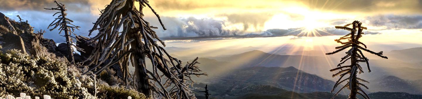
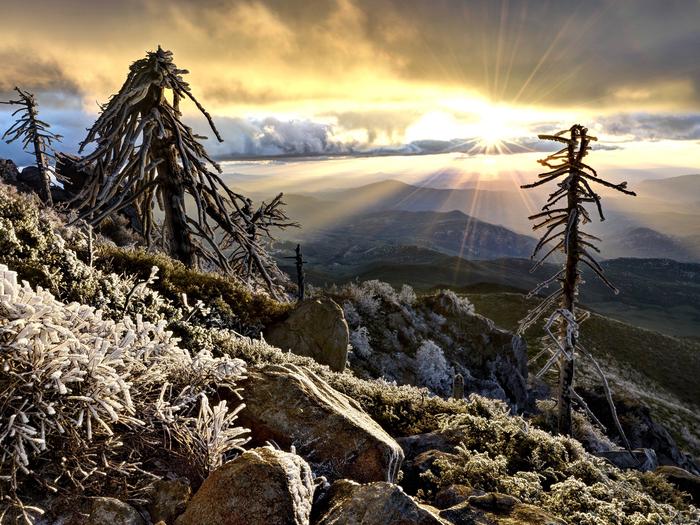
Saddleback Mountain, also known as Santiago Peak, is an intense 15 mile out and back trail with steep inclines and phenomenal city views, with enough challenges to push yourself to the limit. At almost 6,000 elevation, the peak is the highest point in Orange County, offering incredible views that span from Catalina Island to Orange and Riverside counties.
| Mossy trails | Tranquil streams |
 |  |
Although it is one of the more difficult trails in Orange County, this back country road also offer an almost rain-forest like environment with overgrown ferns and moss, large fig trees, and small running streams. Historical to early Orange County, this area still displays many remnants of the late 1800's when bee keeping and woodcutting was the main occupation of mountain dwellers
For a list of more trails to explore in your area, please see our Recreation Trail Guide
Agua Dulce Equestrian Trailhead Facility
Agua Dulce Equestrian Trailhead
Distance | 1.8 - 2.3 miles (one way) depending on trail connection |
Pets Allowed | Yes |
Fees | |
Hike/Ride Time | Full day |
Difficulty | Easy to Strenuous - dependent on connection |
Best Seasons | Fall, Spring, Winter |
Location | Off Sunrise Hwy 1 and Wooded Hill Road. See Map Below. |
Ranger District | Descanso Ranger District - (619) 445-6235 |
Agua Dulce Equestrian Trailhead is a great opportunity to access multiple trails for varying skill levels. The parking area was designed to accommodate larger vehicles so equestrian trailers and larger groups. Aqua Dulce Trailhead is adjacent to the Old County Road which connects users to the Wooded Hill Nature Trail and the Big Laguna Trail Spurs (See Chico and Gatos Ravine).
Agua Dulce is adjacent to the Wooded Hill Group Campground and is located down Wooded Hill Road/Old County Road off of Sunrise Highway on Mount Laguna. The Visitor’s Center as well as food and lodging are within several miles of the trailhead, located in Mount Laguna. Recreation fees are required to park and use the amenities at this trailhead. Adventure Passes and Daily Recreation Passes can be purchased on Mount Laguna at the Visitor’s Center, Blue Jay Lodge, the Laguna Country Store
For a list of more trails to explore in your area, please see our Recreation Trail Guide
Trabuco Creek Picnic Site Facility

Trails Closeby | Holy Jim Falls trailhead located approximately 1.5 miles away |
Pets Allowed | Yes |
Fees | |
Best Seasons | Spring, Winter |
Location | Off Trabuco Canyon Rd near Live Oak Road Canyon rd |
Ranger District | Trabuco Ranger District - (951) 736-1811 |
The refreshing Trabuco Creek picnic area takes recreation enthusiasts through oak woodlands and tall sycamores before settling into a creekside riparian area nestled in a grassy thicket. Spring and Winter are often the best time to picnic here as the streams are typically flowing after and during the rainy season. Located in the heart of the Silverado Canyon area, this picnic area is a short stretch from Holy Jim Falls and in close proximity to the popular Silverado Motorway.
Red-tailed Roost Trailhead Facility
Red-Tailed Roost Trailhead

Distance | 3.4 miles |
Pets Allowed | Yes |
Fees | None |
Hike/Ride Time | Half day |
Difficulty | Moderate |
Best Seasons | Fall, Spring, Winter |
Location | Near mile marker 22.5 on Sunrise Hwy. See Map |
Ranger District | Descanso Ranger District - (619) 445-6235 |
A lovely area in the Laguna Mountains surrounded by black oaks and confier, the Red Tail Roost connects not only to the Big Laguna Trail System via Escondido Ravine Rd, but also to a number of spur trails, easily recognizable through posted signage. Great area for picnicking or short family hikes. Connects to the Red-tailed Roost loop spur, consisting of 3.4 miles with moderate incline and downhill sections. Add .6 miles if connecting to the Big Laguna from Escondido Spur trail. Hiking the entirety of Big Laguna will add an additonal 10 miles from this point.
For overnight camping enthusiasts, Burnt Rancheria Campground is a mere mile away and Wooded Hill Campground is a short half mile stroll.
For a list of more trails to explore in your area, please see our Recreation Trail Guide
Three Sisters Falls Facility


Elevation Change | 1000 |
Distance | 4.5 miles |
Hike/Ride Time | Full day |
Difficulty | Moderate to Strenuous |
Best Seasons | Spring, Winter |
Ranger District | Palomar Ranger District - (760) 788-0250 |
Gaining in popularity, this often crowded, yet challenging hike takes hikers through several ecosystems before leading to the main event - three large waterfalls wedged between tall, rocky mountains. Having recently undergone some new developments, hikers will find a safer and more direct route to the falls, which alleviates the need to rock/mountain climb, lowering injury risks and casualty rates. Those who are interested in extreme hiking, mountain climbing, rock traversing, or otherwise challenging hikes will still appreciate elements of this trail, particularly if hiking to the third waterfall or traversing the rocky bottom.
If you do not feel you are ready for the intensity of this hike, please reference our Recreation Trail Guide for a list of other options in this area. For more information on this hike, please see our Three Sisters Trail Spotlight Feature
Camping Area (6S07F) Facility
Trail difficulty: Trail segment is rated as easy.
