
Lassen National Forest

Recreation is one of the premier opportunities for visitors to the Lassen National Forest. From springtime wildflower hikes to snowmobiling miles of freshly groomed trails in the winter, there is something for everyone! So go explore, camp, hike, kayak, fish, or just sit beneath the towering pines on a sunny afternoon and relax... the Lassen National Forest welcomes you!
Here are some of our favorite places on the Lassen National Forest. We hope that you enjoy them as much as we do! Please note that pets must always be restrained or on a leash while in developed recreation sites, and that pets (except guide dogs) are not allowed in swimming areas.
RecAreaDirections
Open with Google Map
Misc
| Stay Limit | |
| Reservable | false |
| Keywords | |
| Map Link | |
| Contact Phone | |
| Contact Email |
Permits info
Facilities
Aspen Grove Campground (CA) Campground
List of CampsitesOverview
Aspen Grove Campground is located in the Eagle Lake Recreation Area of the Lassen National Forest. This recreation area has five campgrounds, 3 day use areas and a marina on the south shore of Eagle Lake. These facilities are connected by a 5.2 mile paved hiking/bike trail. The Osprey Overlook, another day use area can be hiked or driven too for a scenic view of the southern end of Eagle Lake and the surrounding forest basin.
The Lassen National Forest offers a variety of lakes, streams and wilderness areas for recreational opportunities. The forest offers miles of trails that are used for hiking, mountain biking, off-highway vehicle riding and during the winter months, snowmobiling.
Recreation
Fishing for the Eagle Lake Rainbow Trout, a California Heritage Trout, is the primary recreational activity on Eagle Lake, but the 3rd largest natural lake in California (22,000 acres), provides for plenty of room for swimming, kayaking, skiing and all other boating activities by motor or sail. There are no 2-cycle restrictions for outboard boat motors or PWCs. Aspen Campground is adjacent to the designated, roped-off swim area at the Gallatin Beach Day Use Area.Facilities
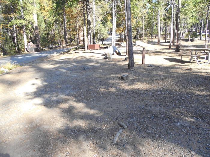
Aspen Grove Campground is a tent-only designated campground. Camping vehicles of any type and generators are not allowed in the campground. Wheelbarrows are provided in order to assist you in moving your tents and other camping gear to and from your campsite. Eighteen sites, numbers 11-28 can be reserved and sites 1-10 are designated walk-in, first-come, first-served sites.
Each site is equipped with a table and a campfire ring with grill. The campground has flush toilets, potable water points, and firewood is available for purchase. The paved bike path runs through the campground. (THE EAGLE LAKE MARINA STORE IS CURRENTLY CLOSED IN 2022) The Eagle Lake Marina store with gas, propane, fishing and camping supplies, rental boats, shower and laundry facilities and the South Shore Grill with hot food cooked to your order is an easy 10 minute walk from the campground.
Natural Features
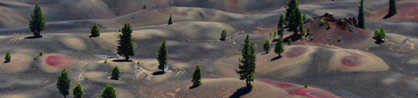
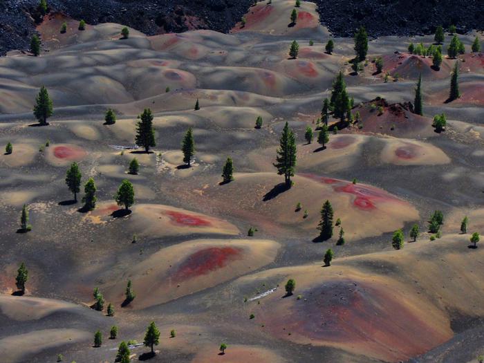
Eagle Lake is located where the Sierras meet the Cascades and the Modoc Plateau of the Great Basin. This unique location offers diverse landscapes, geology, wildlife and vegetation. Aspen Campground is located in a mature conifer forest of pines and firs, with a strip of aspen between the campsites and the lake's shoreline, at an elevation of 5,100 feet.Nearby Attractions
The Lassen National Forest has many other recreational opportunities and the Lassen Volcanic National Park is an easy day’s roundtrip drive from Eagle Lake Recreational Area.ALMANOR Campground
List of CampsitesOverview
Almanor Campground is a large family-friendly facility for individuals and large groups alike. It provides direct access to beautiful Lake Almanor and a variety of recreational opportunities in the area.Recreation
The 28,000-acre lake provides ample boating, swimming, water skiing and sailing opportunities. A boat ramp can be found next to the north campground. The adjacent beach is mostly rocky, but contains some sand.
Fishing in the lake or nearby streams, is a popular activity. Anglers will find a variety of trout, bass, salmon and catfish, among other species.
The Lake Almanor Recreation Trail can be accessed from within the campground. The trail winds through the forest, providing spectacular views of the lake, nearby Dyer Mountain and Lassen Peak. The trail stretches approximately 11 miles along the west shore of the lake. It is a non-motorized trail, open to all non-motorized activity.
Facilities
The campground offers numerous single-family campsites, as well as a group site. Campsites are available for tent and RV camping, however, no hookups are provided. Many sites are available on a first-come, first-served basis.Each site is equipped with a table and campfire ring with grill. Accessible vault toilets and drinking water are provided. Limited parking is available at the campground. An amphitheater is located on-site.
Natural Features
The campground sits on the west shore of Lake Almanor at an elevation of 4,540 feet. A scenic mixed conifer forest covers the area. Parts of the campground are shaded, while other sections have grassy meadows that often contain wildflowers.Nearby Attractions
The campground is located 12 miles outside of the town of Chester, California.EAGLE CAMPGROUND Campground
List of CampsitesOverview
Eagle Campground is located in the Eagle Lake Recreation Area of the Lassen National Forest. This recreation area has five campgrounds, three designated day use areas and a marina on the south shore of Eagle Lake. All of these recreation facilities are connected by a 5.2 mile paved hiking/bike trail. The Osprey Overlook, another day use area in the recreation area, can be hiked or driven to for a scenic view of the southern end of Eagle Lake and the surrounding forest basin.
The Lassen National Forest offers a variety of lakes, streams and wilderness areas for recreational opportunities. The forest offers miles of trails that are used for hiking, mountain biking, off-highway vehicle riding and in the winter months, snowmobiling.
Recreation
Fishing for the Eagle Lake Rainbow Trout, a California Heritage Trout, is the primary recreational activity on Eagle Lake, but the 3rd largest natural lake in California (22,000 acres), provides for plenty of room for swimming, kayaking, skiing and all other boating activities by motor or sail. There are no 2-cycle restrictions for outboard boat motors or PWCs.
Facilities
Within Eagle Lake Recreation Area, Eagle Campground is the closest campground to the marina/boat launch that offers RV/trailer camping sites. Eagle’s other distinction is its location in an exceptional stand of tall pines. There are 30 reservation sites, 20 walk-in sites, two small group sites and two sites that have electric and water hook-ups.
Each site is equipped with a paved parking spur (except #50/gravel), table and campfire ring/grill.
An RV Dump Station Facility is conveniently located about 2.5 miles away with a $5 dump fee.
The paved bike path is connected to this campground. (THE EAGLE LAKE MARINA STORE IS CURRENTLY CLOSED IN 2022) The Eagle Lake Marina store with gas, propane, fishing and camping supplies, rental boats, shower and laundry facilities and the South Shore Grill with hot food prepared to your order, and boat launch is located about one mile from the campground.
Natural Features
Eagle Lake is located where the Sierras meet the Cascades at the southwestern end of the lake, and the Modoc Plateau of the Great Basin at the northeastern end. This unique location offers diverse landscapes, geology, wildlife and vegetation.
Eagle Campground is located in a mature conifer forest of pines and firs, on the southern shoreline of Eagle Lake, at an elevation of 5,100 feet.
Nearby Attractions
The Lassen National Forest has many other recreational opportunities and the Lassen Volcanic National Park is an easy day’s drive to and from Eagle Lake Recreational Area.
HAT CREEK Campground
List of CampsitesOverview
Hat Creek is one of six campgrounds available in the Hat Creek Recreation Area, home to some of the area's best trout fishing. Scenic hiking trails and an active volcanic area can easily be accessed from the facility.Recreation
Hat Creek is popular for its trophy trout fishing. The cold waters of the creek allow for a refreshing play on hot summer days. Other popular activities in the area include wildlife viewing, hunting, backpacking, hiking and caving.A variety of day hikes are available in the area, including the Spatter Cones Nature Trail, which is located just across the highway from the campground. The 1.5-mile loop trail provides hikers with a unique opportunity to explore craters, cones and crevices, as well as other geologic features left by the Hat Creek Lava Flow.
Nearby, visitors can take a self-guided tour of Subway Cave. The trail is less than a half-mile long and explores the underground world of a lava tube. Visitors are encouraged to bring flashlights for hiking through the cave.
Facilities
Hat Creek offers three group campsites that can accommodate up to 50 people each. Individual sites are also available on a first-come, first-served basis.Picnic tables and campfire rings with grills are provided, as are accessible flush and vault toilets, utility sinks and drinking water. The RV dump-station is located 1.5 miles north of the campground behind the Old Station Visitors Center.
Natural Features
The campground is situated next to Hat Creek in a mixed conifer forest at an elevation of about 4,390 feet. Pine needles, grasses and volcanic rocks cover the forest floor. Sites are widely spaced for privacy.Nearby Attractions
The campground is located about a mile west of the town of Old Station, and 12 miles east of the northwest entrance to Lassen Volcanic National Park, where active, hissing fumaroles and boiling mud pots are continually shaping the landscape.The Pacific Crest National Scenic Trail can be accessed near the Spatter Cones Nature Trailhead.
GURNSEY CREEK Campground
List of CampsitesOverview
Gurnsey Creek Campground is located in the mountains of northern California. It offers access to a variety of nearby recreational opportunities, including hiking, fishing and picnicking.Recreation
The area provides access to plentiful hiking trails, picnic spots and rainbow trout fishing.Facilities
Dozens of individual campsites and two reservable group sites are available at Gurnsey Creek Campground. Group Site 1 can accommodate up to 56 people; Group Site 2 can accommodate up to 112 people.
Picnic tables and campfire rings with grills are provided, as are accessible vault toilets and drinking water. No utility hookups are provided. A water-filling station is located at the campground entrance. Parking is limited within the campground.
Natural Features
The campground is nestled in a mixed conifer forest in the Lassen National Forest at an elevation of 4,700 feet. It is located next to Gurnsey Creek.Nearby Attractions
The campground is located 14 miles west of the town of Chester and Lake Almanor, where boating, fishing, sailing and water skiing are popular activities.The southwest entrance to Lassen Volcanic National Park is about 14 miles north. The park is known for its active hissing fumaroles and boiling mud pots that continually shape and alter the landscape.
CHRISTIE CAMPGROUND Campground
List of CampsitesOverview
Christie Campground is located in the Eagle Lake Recreation Area of the Lassen National Forest. This recreation area has five campgrounds, three designated day use areas and a marina on the south shore of Eagle Lake. All these recreation facilities are connected by a 5.2 mile paved hiking/bike trail. The Osprey Overlook, another day use area in the recreation area, can be hiked or driven to for a scenic view of the southern end of Eagle Lake and the surrounding forest basin.
The Lassen National Forest offers a variety of lakes, streams and wilderness areas for recreational opportunities. The forest offers miles of trails that are used for hiking, mountain biking, off-highway vehicle riding and in the winter months, snowmobiling.
Recreation
Fishing for the Eagle Lake Rainbow Trout, a California Heritage Trout, is the primary recreational activity on Eagle Lake, but the 3rd largest natural lake in California (22,000 acres), provides for plenty of room for swimming, kayaking, skiing and all other boating activities by motor or sail. There are no 2-cycle restrictions for outboard boat motors or PWCs.
Facilities
Of the five campgrounds in the recreation area, Christie Campground is located the greatest distance from the marina and boat ramp, about five miles or a 10-minute drive. Due to its location, this campground is the least used and occupied in the recreation area. This distinction has developed a very loyal customer base of RV, trailer and tent campers who want a quiet, spacious, camping experience in this beautiful landscape.
Christie Campground’s location offers OHV riders almost direct access to the Forest Service riding trails and roads and is preferred by kayak and personal pontoon fishing enthusiasts.
Each site is equipped with a paved parking spur, table and campfire ring/grill. Almost half of the sites feature a pull-through parking spur and nine of these sites are large enough that they have been designated as group sites.
An RV Dump Station Facility is conveniently located about two miles away with a $5 dump fee.
Forty-seven sites, #1-#25, #27-#30, and #32-#49 are designated reservation sites, the other 22 sites are walk-in sites, available on a first-come, first-served basis.
The paved bike path begins in this campground. (THE EAGLE LAKE MARINA STORE IS CURRENTLY CLOSED IN 2022) The Eagle Lake Marina store with gas, propane, fishing and camping supplies, rental boats, shower and laundry facilities and the South Shore Grill with hot food prepared to your order, and boat launch is located five miles from the campground.
Natural Features
Eagle Lake is located where the Sierras meet the Cascades at the southwestern end of the lake, and the Modoc Plateau of the Great Basin at the northeastern end. This unique location offers diverse landscapes, geology, wildlife and vegetation.
Christie Campground is located in a mature conifer forest of pines and firs, on the southwestern shoreline of Eagle Lake, at an elevation of 5,100 feet.
Nearby Attractions
The Lassen National Forest has many other recreational opportunities and the Lassen Volcanic National Park is an easy day’s drive to and from Eagle Lake Recreational Area.
MERRILL CAMPGROUND Campground
List of CampsitesOverview
Merrill Campground is located in the Eagle Lake Recreation Area of the Lassen National Forest. This recreation area has five campgrounds, three designated day use areas and a marina on the south shore of Eagle Lake. All of these recreation facilities are connected by a 5.2 mile paved hiking/bike trail. The Osprey Overlook, another day use area in the recreation area, can be hiked or driven to for a scenic view of the southern end of Eagle Lake and the surrounding forest basin.The Lassen National Forest offers a variety of lakes, streams and wilderness areas for recreational opportunities. The forest offers miles of trails that are used for hiking, mountain biking, off-highway vehicle riding and in the winter months, snowmobiling.
Recreation
Fishing for the Eagle Lake Rainbow Trout, a California Heritage Trout, is the primary recreational activity on Eagle Lake, but the 3rd largest natural lake in California (22,000 acres), provides for plenty of room for swimming, kayaking, skiing and all other boating activities by motor or sail. There are no 2-cycle restrictions for outboard boat motors or PWCs.Facilities
Merrill Campground is a unique US Forest Service facility. Totally rebuilt in the early 2000s, it is the prototypical RV park in a Forest Service campground. With 57 full hook-up sites, 64 partial hook-up sites and 51 standard, no hook-up sites, Merrill offers whatever type of site you prefer. Partial hook-up sites have water and electric, no sewer. All electric hook-up sites have a 50, a 30 and two 20 amp outlets provided.
All site camping/parking spurs are at least 45 feet, but most are 55 to 75 feet in length, and are essentially double wide. Each site is equipped with a table and a campfire ring with grill. The campground has flush toilets, potable water points, grey water dumps, limited WIFI and firewood is available for purchase. An RV Dump Station Facility is conveniently located just outside the campground with a $5 dump fee.
Forty-five sites, #15-#42 and #57-#75, are designated walk-in sites, the other 125 are reservation sites.
The paved bike path runs through the campground. (THE EAGLE LAKE MARINA STORE IS CURRENTLY CLOSED IN 2022) The Eagle Lake Marina store with gas, propane, fishing and camping supplies, rental boats, shower and laundry facilities and the South Shore Grill with hot food prepared to your order, and boat launch are located 2.5 miles from the campground.
Natural Features
Eagle Lake is located where the Sierras meet the Cascades at the southwestern end of the lake, and the Modoc Plateau of the Great Basin at the northeastern end. This unique location offers diverse landscapes, geology, wildlife and vegetation.Merrill Campground is located in a mature conifer forest of pines and firs on the southern shoreline of Eagle Lake, at an elevation of 5,100 feet.
Nearby Attractions
The Lassen National Forest has many other recreational opportunities and the Lassen Volcanic National Park is an easy day’s drive to and from Eagle Lake Recreational Area.WEST EAGLE CAMPGROUND Campground
List of CampsitesOverview
West Eagle Campground is part of the Eagle Lake Recreation Area in the Lassen National Forest, which offers a variety of lakes, streams and wilderness areas and an abundance of recreation opportunities.In addition to water sports on the lake, the area also offers miles of trails that are used year-round for hiking and mountain biking and by snowmobiling enthusiasts during the winter months.
Recreation
The 27,000-acre lake provides ample boating, swimming, water skiing and sailing opportunities. Visitors also enjoy the plentiful trout fishing. A boat ramp can be found not far from the campground, and a beach is located at the nearby Aspen Campground.The campground offers access points for miles of trails within the Eagle Lake Recreation Area. A 6-mile hiking, biking and horseback riding trail parallels the lake and winds through the surrounding forest.
Facilities
West Eagle Campground offers two group sites for tent or RV camping. One site can accommodate up to 75 guests, while the other is rated for up to 100 guests.Each site is equipped with tables and campfire rings with grills. Accessible flush toilets, electricity and drinking water are provided. Firewood is available for purchase.
Natural Features
The campground is located on the southeastern shores of Eagle Lake, in northeastern California, at an elevation of approximately 5,100 feet. It is nestled in a forest of mature pine trees with a grassy understory. A few sites offer sweeping views of the adjacent lake and some have space to moor a boat.MCCARTHY POINT LOOKOUT Campground
List of CampsitesOverview
McCarthy Point Lookout was constructed in 1936 by the Civilian Conservation Corps for use in spotting wildfires. During World War II, the lookout served as part of an aircraft defense monitoring system that extended throughout California. The lookout is accessible by vehicle, but a high-clearance vehicle is recommended. Guests must walk approximately 1,000 feet along a paved trail to reach the lookout from the parking area. This is a high cliff area, so caution is advised. The cabin offers several creature comforts, but guests may need to bring some supplies and gear for their stay. The scenic views and remote location make McCarthy Point Lookout an ideal retreat.Recreation
The lookout is an excellent base for exploring the recreational opportunities of the Ishi Wilderness. Many hiking and equestrian trails crisscross the Wilderness.Special fishing regulations are in effect for Mill and Deer Creeks within the Wilderness. Please check the State of California’s Fishing Regulations before fishing. A valid California fishing license is required.
Facilities
McCarthy Point Lookout is a two-room cabin with a kitchen and a bedroom. The bedroom is surrounded on three sides by windows and has overhead propane lights, two single-sized sleeping platforms and six aluminum cots. The kitchen has overhead propane lights, a propane cook stove, wood stove, double sinks with running non-potable water (hot water is not available), a large picnic-style table with benches and a portable gas barbecue. Propane is provided. There is a broom and dust pan for tidying up the cabin. Wheeled carts are provided to transport gear to the lookout. An outhouse with a pit toilet is located at the parking area. The cabin does not have potable water or electricity. Guests need to provide their own drinking water. Garbage bags are needed to pack out trash. Items such as bedding, sleeping pads, cooking pots, utensils, dishes, dish soap, toilet paper, paper towels, matches and flashlights are not provided.Natural Features
The lookout is perched at an elevation of 3,600 feet on the southern end of Mill Creek rim overlooking scenic Mill Creek Canyon and the Ishi Wilderness. The cabin is tucked into a stand of mixed evergreens. McCarthy Point is located within a state game refuge that protects species like wild hog, mountain lion, black bear, coyote, bobcat, Tehama deer and rabbit. A variety of raptors nest on rock cliffs in the nearby Ishi Wilderness, including hawks, eagles, falcons and owls. Other common bird sightings include wild turkey, quail, canyon wrens, band-tailed pigeons and myriad songbirds.Nearby Attractions
Ishi WildernessFeather River Homesites Facility
Recreation residences under Special Use Authorization
Moak Trailhead Facility
Wilderness trailhead
Willow Lake Campground Campground
List of CampsitesA heavily used dispersed camping area located just south of Lassen Volcanic National Park, Willow Lake is known for its unique floating bog and good fishing. The Terminal Geyser trailhead is accessible from here.
Colby Meadows Winter Recreation Area Facility
The Colby Meadows area offers 9 miles of ungroomed cross-country ski trails for beginning and advanced skiers. Colby Meadows is located on the western slope of the Sierra Nevada Range. Take Highway 32 to the Humboldt Road (County Road 91422) to the Jonesville Snowmobile staging area. Start at forest road 27N07 off of the Humboldt Road. Skiers are reminded to park away from the groomed trails so snowmobilers can access them. Elevation ranges from 4,800 to 6,000 feet. The average snow pack is three feet on the lower elevations and up to five feet or more at Colby Mountain Lookout. Trails are marked with aqua-blue diamonds and signed to indicate skill level. The cross-country ski trails in this area are closed to all motorized vehicles.
Jonesville Homesites Facility
Recreation residences under Special Use Authorization
PCT Domingo Springs Trailhead Facility
PCT trailhead
Christie Day Use Facility
Day use area on the south end of Eagle Lake. Camping is not allowed.
Bunchgrass Trailhead Facility
Bunchgrass Trailhead is the southern access to the Thousand Lakes Wilderness. The moderate trail is 3.5 miles through lodgepole pine and open country.
McClure Trailhead Facility
Accesses a 5.4 mile non-motorized trail that follows Antelope Creek.
McGowan Cross-Country Ski Area Facility
The McGowan Lake Cross-Country Ski Area has been in existence since 1982 and offers 10 miles of trails, 5 miles of which are periodically groomed. Access is on Highway 89, 2 miles north of Highway 36 and near the southern entrance to Lassen Volcanic National Park. Literally in the shadow of Lassen Peak, McGowan area trails wander through mixed conifer forest and are popular with beginning to advanced skiers. Elevations range from 5,020 to 6,200 feet. McGowan cross-country ski trails are closed to all motorized vehicles.
PCT Humboldt Summit Trailhead Facility
PCT trailhead
Lake Almamor Trail Dyer View Trailhead Facility
Lake Almanor Recreation Trail - non motorized, paved
Osprey Overlook Facility
Scenic overlook with mural.
Cold Springs Facility
PCT trailhead and parking area
Deer Creek Trailhead North Facility
Accesses the Deer Creek Trail from Highway 32 at the Red Bridge. Deer Creek Trail follows Deer Creek to the southern trailhead/parking area at the eastern boundary of the Ishi Wilderness.
PCT Mud Lake Facility
Pacific Coast Trail
Long Point Facility
Dispersed camping
Swain Mountain Snowmobile Park Facility
Located just off County Road A-21, Swain is located approximately 9 miles north of Westwood. The area can also be accessed just east of Chester at the Chester-Lake Almanor Staging Area on Highway 36. Swain Mountain has 60 miles of groomed trails, which include three loop trails. All routes are easy.
Swain Mountain is considered the hub of the forest's snowmobile trail system. It is usually the first staging area to open with enough snow for snowmobiling when winter commences and the last area to thaw in the spring. The area provides direct access to the Bogard and Fredonyer trail systems, offering 200 miles of marked trails (both groomed and ungroomed). Visitors to Swain Mountain are reminded that there are restricted use areas (Caribou Wilderness and Lassen Volcanic National Park) in close proximity to the groomed trails in this area.
Stover Mountain Facility
Stover Mountain
Silver Bowl Picnic Facility
Picnic day use area
Deer Creek Falls Facility
A scenic stop along Highway 32, Deer Creek Falls runs at the base of a short trail marked by an informational kiosk.
Almanor Picnic Facility
Generally open from May 15 through November
Silver Bowl Campground Campground
List of CampsitesLocated near the shores of Silver Lake, Silver Bowl is a developed campground with 18 designated sites. There is a maximum of 8 people per site. Silver Lake offers a boat launch ramp, and a nature trail encircling the lake and two picnic areas provide a variety of recreational pursuits. Caribou Wilderness trailheads are located nearby.
Aspen Grove Launch Area Facility
Launch located in parking area at Aspen Grove campground.
Yellow Creek Facility
Operated by PGE
PCT Poison Springs Trailhead Facility
PCT trailhead - dispersed camping
Silver Beach Picnic Area Facility
An unpaved boat launch and parking area, Silver Beach Picnic Area offers opportunities for water play, picnicking, fishing, and hiking. The Silver Lake trail is accessible from the beach area and the Caribou Wilderness is only minutes away.
Warner Creek Campground Campground
List of CampsitesA developed campground with 13 designated sites. A maximum of 8 people is allowed per site. Grills and tables are provided.
Deer Creek Trailhead South Facility
Wilderness trailhead accessible via Ponderosa Way (Forest Road 28N29) on the Ishi Wilderness boundary.
Elam Campground Campground
List of CampsitesDeveloped campground with 15 designated sites; most can accommodate an RV. Maximum of 8 people per site. Grills and tables provided.
Crater Day Use Facility
Day use area
Battle Creek Campground Campground
List of CampsitesBattle Creek Campground is a developed campground with 50 designated sites and a maximum of 8 people per site. Grills and tables are provided. Battle Creek Campground is close to Lassen Volcanic National Park which offers many diverse hiking trails and other outdoor amenities. Battle Creek Campground is located on Highway 36 approximately 2 miles west of Mineral, CA, and 38 miles east of Red Bluff, CA.
Stover Springs Facility
Dispersed camping
Philbrook Boat Launch Facility
Operated by PGE
Devil's Den Trailhead Facility
Wilderness trailhead located at the southeastern boundary of the Ishi Wilderness.
Mill Creek Facility
Mill Creek
Camp Tehama Facility
Organization Camp under Special Use Authorization
Eagles Nest Facility
Recreational residence area.
Potato Patch Campground Campground
List of CampsitesPotato Patch Campground is shaded by towering pines and firs and conveniently located along Deer Creek. Potato Patch Campground is a very popular spot for getting away from the valley heat. A developed campground with 32 designated sites, there is a maximum of 8 people per site. Some sites equipped to accommodate RVs and/or are ADA accessible. Grills and tables are provided. Excellent trout fishing can be found all along Deer Creek.
Hole-in-the-Ground Campground Campground
List of CampsitesTrue to its name, Hole-in-the-Ground is tucked away in a steep, tree-covered draw alongside Mill Creek. A developed campground with 13 designated sites, there is a maximum of 8 people per site at this campground. Grills and tables are provided.
Locherman Canyon Facility
Locherman Canyon is a one-mile interpretive trail and outdoor classroom with an amphitheater. Call the Almanor Ranger District office at 530-258-2141 for more information.
Mill Creek Homesites Facility
no longer National Forest
Dow Butte Lookout Facility
Dow Butte Lookout is a former fire lookout now available for the public to tour and enjoy the view.
Rocky Knoll Campground Campground
List of CampsitesDeveloped campground near Silver Lake with 18 designated sites, some of which can accommodate RVs. Water is available via hand pump. Grills and tables are provided.
Silver Lake Homesites Facility
Recreation residences under Special Use Authorization
Caribou Wilderness Facility
The Caribou Wilderness is a gentle, rolling, forested plateau dotted with glacial lakes. Reminders of volcanic and glacial origin are apparent throughout this remote, unpopulated area. Crater peaks, cinder cones, and numerous large and small depressions have resulted in the formation of the crystalline lakes that are scattered throughout the plateau.
Caribou Peaks, Black Cinder Rock, and Red Cinder are points of interest. The average elevation is 6,900 feet. The highest point, Red Cinder, is 8,370 feet. From here there are majestic views of the lofty mountains that surround this primitive wilderness. Located on the eastern slopes of what was once Mount Tehama, this area is surrounded by the volcanic peaks of Swain Mountain, Bogard Buttes, Prospect Peak, Ash Butte, Red Cinder Cone and Mount Harkness.
The Forest cover is mostly lodgepole pine with a mixture of jeffrey pine, white and red fir, western white pine, and hemlock. In early summer, wildflowers brighten the trail and water lilies cluster in ponds.
The headwaters of the Susan River originate in the Caribou. This water percolates up through the porous volcanic aquifer and is a major year around water source for the east slope of the Cascades. While scouting out a route to bring wagon trains through, early day hunting parties also ventured into the Caribou area to find game for survival. Today, their route is known as the Lassen Trail.
The larger lakes that are deep enough to support fish are home to brook and rainbow trout. Some familiar birds that make their home in the Caribou are the bald eagle, osprey, common merganser, eared grebe, and many types of ducks.
The summer use period is approximately June 15 to October 15, although early spring could open up the lower areas by Memorial Day. Hypothermia can be a problem in spring and fall seasons with cold rains. Check our Current Conditions page for weather conditions.
Deer Creek Trailhead Facility
4.6 miles round-trip; day use only. Trailhead accessible at the Red Bridge crossing on Highway 32.
Brokenshire Picnic Area Facility
Day use picnic area. Tables provided.
Bogard Visitor Center Facility
Roadside rest stop off Highway 44. No fee. No camping or overnight parking. Restrooms. Piped water. Near snowmobile trailheads.
Roxie Peconom Campground Campground
List of CampsitesCampground located 2 miles off highway 36. There are 10 walk in sites, hand pumped water and vault toilet.
Fredonyer Parking Area Snowpark Facility
Fredonyer Parking area provides a great launch spot for all winter activities including snowshoeing, crosscountry skiing and snowmobiling.
Philbrook Campground Campground
List of CampsitesOperated by PGE
Domingo Springs Campground Campground
List of CampsitesDeveloped campground with 18 designated sites. Maximum of 8 people per site. Grills and tables are provided. The local Maidu Indians referred to this spot as the "center of the universe".
Mill Creek (Hole in the Ground) Trailhead Facility
Hiking trail
Philbrook Picnic Facility
Operated by PGE
Mt Lassen Assemblies of God Facility
Organization Camp under Special Use Authorization
Butte Meadows Campground Campground
List of CampsitesDeveloped campground with 13 designated sites. Maximum of 8 people per site. Grills and tables provided.
Gallatin Beach Facility
Day use area near Aspen campground. Great for family fun, sandcastles, sunbathing, and swimming. No lifeguard on duty.
Old Station Day Use Picnic Facility
Day use picnic area located on Hat Creek. The day use area has an accessible picnic area. There are vault toilets but no running water.
Almanor Beach Facility
A large day use beach with a swimming area protected by buoys to separate swimmers from motor boats, jet skis, and other lake users. Ample parking is provided within walking distance.
Mill Creek Trailhead/Black Rock Campground Campground
List of CampsitesBackcountry campground and wilderness trailhead
Canyon Dam Boat Launch Facility
Boat launch and day use area. Open year round.
Lake Almamor Trail 5 Mile Trailhead Facility
Lake Almanor Recreation Trail - non motorized, paved
Eagle Lake Marina Jetty Facility
Jetty
Will Creek Homesites Facility
Recreation residences under Special Use Authorization
Rancheria Trailhead Facility
Wilderness trailhead
Lassen Trail Trailhead Facility
Wilderness trailhead
Goumaz Facility
Goumaz campground is between Highway 36 and 44 at the South end of Eagle Lake. There are 5 campsites located along Susan River and adjacent to the Bizz Johnson Trail. This is a great place to start a bike ride, walk or horseback ride along the Bizz. There are campfire pits and drinking water is available with one vault toilet. Accessing Goumaz by way of 44 is recommended when towing trailers.
Caribou Lake Trailhead Facility
Wilderness trailhead at eastern boundary of Caribou Wilderness. Access via Silver Lake Road or 10 Road to Caribou Lake. Serves as primary wilderness access. Parking for 20 vehicles and bulletin board provided. Small boats may be launched into Caribou Lake from trailhead when lake levels allow.
Eagle Lake Ranger District Facility
The second largest natural lake in California, Eagle Lake is framed by pine and sage. Camping, fishing, swimming, picnicking, and boating are popular activities. Family and group campgrounds, naturalist activities, marina, boat launch facilities, store, laundry, and showers are available. The seven mile long South Shore Trail is ideal for bicycles or just a pleasant stroll. Eagle Lake is famed for its trophy trout.
Heart Lake Trailhead Facility
A non-motorized National Recreation Trail ideal for hiking and equestrian use, the Heart Lake trail is 4.7 miles along Martin creek with scenic views of Lassen Peak and Brokeoff Mountain.
Rocky Point Facility
Operated by PGE
Almanor Homesites Facility
Recreation residences under Special Use Authorization
Silver Lake Boat Ramp Facility
Dirt ramp car top boats only
Soldier Meadows Campground Campground
List of CampsitesSoldier Meadows is a developed campground with 15 designated sites. A maximum of 8 people is allowed per site. Located in a picturesque meadow near Soldier Creek, the campground is surrounded by a majestic pine and fir forest. Grills and tables are provided.
Cypress Trailhead Facility
This large trailhead offers the best equestrian access for the Thousand Lakes Wilderness. Plenty of parking and turn around room for vehicles and trailers.
The Cypress Trail has a moderate climb of 1000 feet before dropping down to beautiful Lake Eiler and the lower lakes. A connector trails offers access to the upper lakes just 3 miles away and to the majestic Magee Peak.
Middle Ridge Facility
Dispersed camping
Butte Meadows Homesites Facility
Recreation residences under Special Use Authorization
PCT Carter Meadows Trailhead Facility
PCT trailhead
Gallatin Marina Facility
Located at Eagle Lake, the Gallatin Marina offers boat and fishing equipment rentals, open boat storage, slip rentals, boat fuel, showers, laundry, and fish cleaning facilities. Fishing licenses, fishing supplies, camping supplies, ice, clothing, and food are for sale at the Marina store. 530-825-3454
Merrill Amphitheater Facility
Amphitheater
Tamarack Trailhead Facility
This trailhead offers easy access into the Thousand Lakes wilderness. The Tamarack Trail is an easy climb of approximately 3.5 miles to beautiful Lake Eiler and an easy loop through the lower lakes.
Almanor Boat Launch Facility
The boat launch consists of two lanes and a courtesy dock. Generally open mid April through November, depending on conditions. Parking is provided for boat trailers and vehicles.
Spencer Meadow Trailhead Facility
Alpine meadows, tall timber, and flowing creeks await on the Spencer Meadow Trail. Stretching six miles, Spencer Meadow is registered as a National Recreation Trail. See www.americantrails.org for more information on National Recreation Trail designation.
Echo Lake Campground Campground
List of CampsitesDispersed campground. Maximum of 8 people per site.
Upper Rice Creek Facility
Dispersed camping
Hat Creek Rim Overlook Facility
Scenic overlook of the Hat Creek Valley. Interpretive site with access to the Pacific Crest Trail. Picnic tables and vault toilets are located at the overlook, but there is no running water.
Kingsley Cove Trailhead Facility
Trailhead accesses the northwestern boundary of the Ishi Wilderness.
Morgan Summit Snowmobile Park Facility
Located 4 miles east of Mineral on Highway 36, Morgan Summit has 77 miles of groomed trails, a large parking area, restrooms and a warming hut. The Morgan Summit trail system can also be accessed from Mill Creek on Highway 172 and Mineral at the junction of Highways 36 and 172. There are several loop trails that are considered easy, but the old jeep road to Turner Mountain can be difficult as the road is narrow. On a clear day you can see the Sacramento Valley, Sutter Buttes, Lake Almanor and Mt. Shasta from the Turner Mountain Lookout.
Bogard Campground Campground
List of CampsitesQuiet and tucked away from the beaten path. Pine creek adjacent to campground, beautiful aspens in and around campground. Located 1.75 miles off Highway 44. No Fees. 10 sites. Hand pumped water. Vault toilets, Maximum trailer length 25 feet.
Willow Springs Facility
Dispersed camping
Thousand Lakes Wilderness Facility
Located within the southern portion of the Cascade Mountain Range is 16,335 acres of contrasting topography. Thousand Lakes Wilderness is midway between the town of Burney and Lassen Volcanic National Park.
Volcanic and glacial formations, rocky ravines, mountain slopes, open meadows, and stands of lodgepole pine and red fir define the Wilderness. It is dominated by 8,677 foot Crater Peak, the highest point on the Lassen National Forest, and is a reminder of the glacial action that eroded Thousand Lakes Volcano and created the many small lakes and ponds scattered throughout. The lowest point in the Wilderness occurs at the base of the volcano at 5,546 feet.
The seven major lakes that lie within the Wilderness valley contain trout. Several species of wildlife make their home in the Wilderness. With a little luck and a good pair of binoculars you might spot some the more permanent residents; black-tailed deer, black bear, pika, pine marten, northern goshawk, spotted owl, pileated woodpecker, and Clark's nutcracker. Even elk have been known to visit occasionally.
Another critter worth mentioning is the mosquito. At times they are thick and hungry. It would be advisable to carry insect repellent in your pack.
The summer use period is approximately June 15 to October 15, although early spring could open up the lower areas by Memorial Day. Your experience will be enhanced and impacts will lessened by avoiding weekends and holidays, and heavily used areas.
Magee Trailhead Facility
Magee trailhead accesses the high country of Thousand Lakes Wilderness near the stunning Magee Peak. The trail is steep, but offers some breathtaking views.
Black Oak Grove Facility
Five miles southwest of Panther Spring on the Peligreen Jeep Trail, Black Oak Grove is a dispersed camping area available to OHV enthusiasts, hunters, or anyone out for a day on the Peligreen Trail!
Jonesville Snowmobile Park Facility
Jonesville Snowmobile Park is about 2 miles east of Cherry Hill Campground on the Humboldt Road (county Road 91422), which is accessed via Highwas 32. The area can also be accessed from the east end of the Humboldt Road (County Road 308) on Highway 89 along the west shore of Lake Almanor. Jonesville offers 60 miles of groomed trails and three loops. Most routes follow the Humbug and Humboldt Roads. Spectacular lake views can be seen from the Yellow Creek loop while Colby Mountain Lookout is a popular destination.
PCT Cold Springs Trailhead Facility
PCT trailhead - stock water available
Old Station Visitor Information Center Facility
The Old Station Visitor Information Center is the hub of the Hat Creek recreation area. Here you can view interpretive displays including a living trout exhibit (seasonal) and delightful gardens. It is a pleasant stop to get answers to your forest questions. Maps, wood cutting permits, Christmas tree permits (Nov- Dec) nature books and interpretive items are available for sale.
Elam Creek Rest Area Facility
Day use picnic area and rest stop. Picnic tables provided. Restrooms. No Overnight Camping.
Hay Meadows Trailhead Facility
Accesses the southern boundary of the Caribou Wilderness. Ample parking available for vehicles and trailers; popular equestrian staging location.
Almanor RV Dump Station Facility
The Almanor RV Dump Station is open to everyone, and allows four RVs at a time.
Lake Almamor Trail PG&E Trailhead Facility
Lake Almanor Recreation Trail - non motorized, paved
Merrill RV Dump Station Facility
RV Dump Station
Black Rock Campground Campground
List of CampsitesBlack Rock Campground is a dispersed campground situated in the Oak Woodlands along Mill Creek. 6 sites are available for primitive dispersed camping. Grills and tables are provided at each of the 6 sites. Black Rock Campground is open year round.
Black Rock Campground is located on the Northeast corner of the Ishi Wilderness. Hiking in the Ishi and along Mill Creek is wonderful and the fishing in Deer and Mill Creeks can be very rewarding. Black Rock Campground is accessible via Highway 36 east from Red Bluff to Ponderosa Way. Ponderosa Way is a dirt road, not recommended for RVs, that leads to the Ishi Wilderness.
High Bridge Campground Campground
List of CampsitesDeveloped campground with 12 available sites. Maximum of 8 people per site.
Mill Creek Resort Facility
no longer National Forest
Legacy Campground Campground
List of CampsitesLegacy is a developed campground with 14 sites; maximum of 8 people is allowed per single site; 16 people maximum are allowed per double site. Water and electrical hookups are provided at each site, two sets of hook ups are provided at double site 11. An RV pay per use dump station is located next to the campground. Call the Almanor Ranger District for more information at (530) 258-2141.
Upper Deer Creek Facility
Dispersed camping
Ishi Wilderness Facility
In the southern Cascade foothills, approximately twenty miles east of Red Bluff, California, lies the Ishi Wilderness, a unique 41,000 acre, low-elevation wilderness. This is a land incised by wind and water, dotted with basaltic outcroppings, caves, and bizarre pillar lava formations. This is up and down country, a series of east-west running ridges framed by rugged river canyons.
The Ishi is named for a Yahi Yana Indian who was the last survivor of his tribe, who lived in the area for over three thousand years. Shortly after 1850, the white settlers killed all but a handful of the Yahi. Ishi (the Yahi word for man) and a few others escaped and lived quietly for decades in this harsh, wild country.
When visiting the Wilderness, please respect this cultural heritage. Remember that all archaeological and historical sites and artifacts are protected by federal law and should not be disturbed.
The Tehama deer herd, the largest migratory herd in California, winters in the area. Other wildlife include wild hog, mountain lion, black bear, coyote, bobcat and rabbit. Most of the Ishi Wilderness is also a State Game Refuge where hunting is not permitted.
Deer and Mill Creeks are home to many types of fish. However, special fishing regulations are in effect for these streams. Please check the State of California's Fishing Regulations before fishing. A valid California fishing license is required.
Rock cliffs provide nesting sites for a variety of raptors including hawks, eagles, falcons, and owls. Other common sightings include wild turkey, quail, mourning doves, canyon wrens, band-tailed pigeons, and myriad songbirds.
