
Stanislaus National Forest
Click on highway icon to view recreation activities by highway corridor:


We have lots more information about recreation opportunities across the forest!
RecAreaDirections
Open with Google Map
Misc
| Stay Limit | |
| Reservable | false |
| Keywords | |
| Map Link | |
| Contact Phone | |
| Contact Email |
Permits info
Facilities
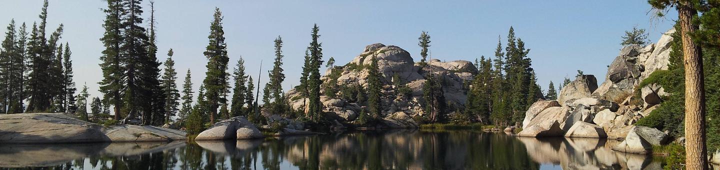
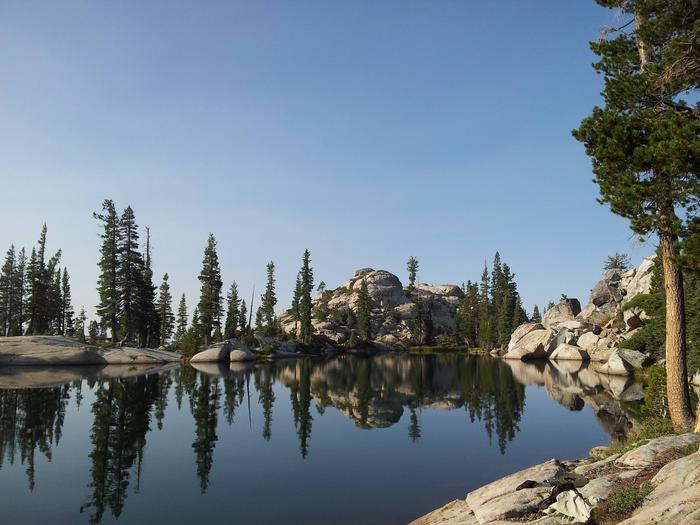
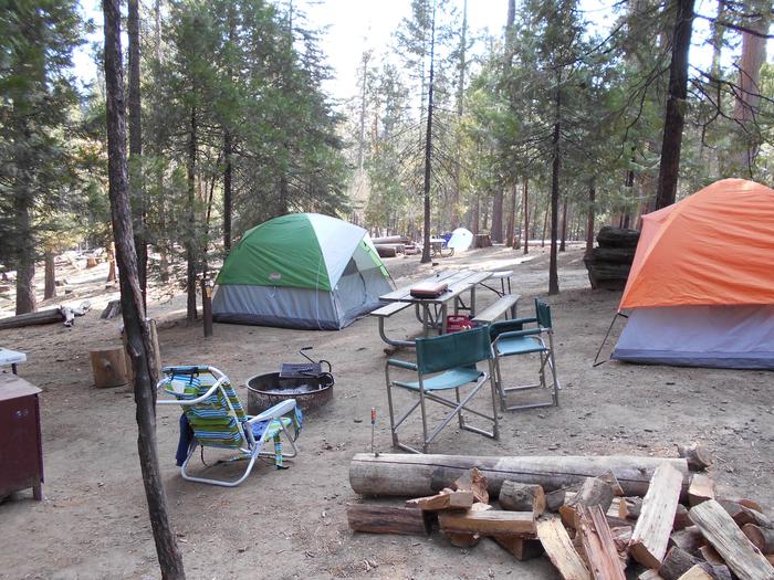
(Lake Alpine) West Shore Campground
List of CampsitesOverview
West Shore Campground sits directly off the north shore of Lake Alpine. It is walking distance to the boat launch, rentals, and Lake Alpine Lodge.
Recreation
Lake Alpine provides a wide variety of recreational opportunities: fishing, hiking, biking, kayaking, paddle-boarding, boating, OHV trails, swimming, rock climbing, and wildlife watching. Interpretive programs are offered by Forest Service rangers during the summer months.
Facilities
Campsites with room for up to 6 people, 3 tents, and 2 vehicles per campsite. Picnic tables, campfire rings, toilets are available. Hot showers and laundromat available at nearby Lake Alpine Resort. No electricity or hook-ups. Pets are welcome. Firewood, camping and fishing supplies, food, and apparel is available in the general store at Lake Alpine Lodge.
Natural Features
West Shore Campground sits at an elevation of 7,400 feet on the north end of Lake Alpine within the Stanislaus National Forest. The forest lies between Lake Tahoe and Yosemite and boasts gorgeous views. Squirrels, chipmunks, deer, marmots, coyotes, bears, eagles, and many different birds make this area their home.
Nearby Attractions
A restaurant, bar, general store, and boat rentals can be found at nearby Lake Alpine Lodge. The immediate area is suited for forest and wilderness recreation. A short car ride away is Big Trees State Park, Grover Hot Springs, Mercer Caverns, Mountain Adventure Seminars, and the wine country of Calaveras County.
(Lake Alpine) Backpackers Campground
List of CampsitesOverview
Backpackers' Campground is located on the East end of Lake Alpine, CA. All sites are walk-in tent sites. Cars cannot be parked in camp, parking is available on the adjacent street.
Backpackers' Campground is located in the Calveras Ranger District, in a timbered setting near several trailheads.
Campground may open earlier and close later as weather (snow level) allows. This information will be posted on this page as soon as it becomes available.
The current dates for reservations have historically allowed for comfortable camping, but please take into consideration the high alpine location when making a reservation. It is possible to have snow, rain, mud, and overall cold/wet conditions any time of year.
Recreation
Lake Alpine provides a wide variety of recreational opportunities: fishing, hiking, biking, kayaking, paddle-boarding, boating, OHV trails, swimming, rock climbing, and wildlife watching. Interpretive programs are offered by Forest Service rangers during the summer months.
Facilities
Campsites with room for up to 6 people, 2 tents, and 2 vehicles per campsite. Picnic tables, campfire rings, vault toilets are available. Hot showers and laundromat available at nearby Lake Alpine Resort. No electricity or hook-ups. Pets are welcome. Firewood, camping and fishing supplies, food, and apparel is available in the general store at Lake Alpine Lodge.
Natural Features
SIlver Valley Campground sits at an elevation of 7,400 feet on the east end of Lake Alpine within the Stanislaus National Forest. The forest lies between Lake Tahoe and Yosemite and boasts gorgeous views.
Nearby Attractions
A restaurant, bar, general store, and boat rentals can be found at nearby Lake Alpine Lodge. The immediate area is suited for forest and wilderness recreation. A short car ride away is Big Trees State Park, Grover Hot Springs, Mercer Caverns, Mountain Adventure Seminars, and the wine country of Calaveras County.
Sweetwater (Stanislaus National Forest) Campground
List of CampsitesOverview
Sweetwater Campground is located on a mixed conifer forested site adjacent to Highway 120, in close proximity to Yosemite National Park. Sites offer camping furniture (picnic tables, campfire pit with grill). Accessible vault toilets are available and potable water is available over the summer season (May – Sep).
Facilities
Sweetwater Campground has 12 single camping units. All units are suitable for tents & RV's (32 ft. max). All interior and spur roads are poaved. Each unit contains at least one picnic table, fire ring and bear box. This is one double vault toilet until (2 toilets). Well water is available and is piped to 3 faucets throughout the campground.
Nearby Attractions
Rainbow Pools is .8 miles from campground and has hiking around it.
Preston Fall Trailhead is 7.3 miles from the campground and is a 4.5 mile hike.
Carlon Day Use area is 9.8 miles from the campground.
Buck Meadow is 3.1 miles from the campground.
Pines Stanislaus Campground
List of CampsitesOverview
Pines Campground is conveniently located, just 15 miles from the Yosemite National Park boundary in northern California. It is an ideal base camp for visitors to explore not only Yosemite, but also the fantastic wilderness areas within Stanislaus National Forest, including Carson-Iceberg, Emigrant and Mokelumne Wildernesses. Pets are welcome, but must be compliant with Tuolumne County leash laws.
Recreation
Hike the Little Golden Forest Trail, a half-mile interpretive loop with the option for a longer two-mile loop. A short drive takes visitors to the Tuolumne River for wading and fishing. Winter sports are very popular in the area as well. Dodge Ridge, Bear Valley and Badger Pass Ski Areas offer a variety of winter activities.
Facilities
In winter, camping is free but water and toilet paper are not provided.
Natural Features
The tranquil campground sits at an elevation of 3,200 feet, in a mixed conifer forest. The Tuolumne River is nearby, which flows for 150 mies from the central Sierra Nevada to the San Joaquin River.
Nearby Attractions
Take a scenic drive through Yosemite National Park to view its legendary waterfalls and scenery.
PINECREST DAY USE AREA Campground
List of CampsitesOverview
Pinecrest Lake is located 40 minutes east of Sonora, California, and is within a 3-hour drive from major metropolitan areas including San Francisco, Sacramento and many valley cities. The lake is located at 5,600 feet elevation and provides cool summer relief, spectacular scenery, and lake shore beaches for relaxing, swimming and picnics.Recreation
Pinecrest Lake is popular for swimming, hiking, kayaking, fishing and sailing (small boats). A nearby resort offers boat rentals, lodging and groceries. Movies and interpretive programs are provided in the evenings at the amphitheater, also located in the day use area. Two campgrounds within the Pinecrest Basin offer opportunities at nearly 300 campsites within one mile from the Pinecrest Day Use Area. *Outdoor movie showings and interpretive programs typically end for the season by mid-October due to weather. Please check for availability.
Facilities
Group use sites are fully accessible and provide group size pedestal grills, food storage boxes, group picnic tables and food prep table. Water hydrants and recycle and garbage cans are also located within the sites. Flush toilets are located nearby.
* Water hydrants are not available during the winter months due to freezing. ** Group sites may be under snow during winter months. Please plan accordingly as accessibility may be limited after heavy snowfall.
Natural Features
The day use area is surrounded by mixed conifer, providing shade during warm summer days. The group picnic sites are located within sight of the lake offering easy access to the lake, beach and hiking trails.Nearby Attractions
The Pinecrest National Recreation Trail traverses Pinecrest Lake for an easy four mile hike. Numerous opportunities for swimming, fishing, boating and lake play are within 100 feet from each group use picnic site.contact_info
For facility specific information, please call (209) 459-9236.PINECREST Campground
List of CampsitesOverview
Pinecrest features a large campground by Pinecrest Lake, just 30 miles east of Sonora, at an elevation of 5600 feet. The area includes a day-use beach and a marina, a small shopping center and recreation cabins. The campground caters to all ages and is within walking distance of the lake, an amphitheater, visitor center, swimming beach and spectacular hiking trails. Pets are welcome, but must be compliant with Tuolumne County leash laws.Recreation
The Pinecrest Lake National Recreation Trail takes hikers on an easy 4-mile stroll around Pinecrest Lake. Rainbow trout is a common catch in the lake and swimming is enjoyed at the sandy beach. Educational programs are also a highlight of the recreation area. Bike rentals are on hand so campers can bike around the area.Facilities
Amenities for each site includes a paved parking pad, picnic table and campfire ring. Drinking water is handy and restrooms have flush toilets, sinks and a utility sink. No RV hookups area available but there is a dump station.Natural Features
Many campsites are shaded by trees and sit near the southwest side of the 300-acre Pinecrest Lake in Stanislaus National Forest. In this beautiful mountain landscape, wildlife viewing opportunities include marmots, squirrels, coyotes and deer.Stanislaus National Forest is situated in the central Sierra Nevada Mountains, between Lake Tahoe and Yosemite. The area boasts gorgeous views of snow-capped mountain peaks and California's Great Central Valley.
Nearby Attractions
Sonora Pass, a scenic winding highway that has guided people across the Sierra Nevada since 1852, is located nearby.Big Meadow - US Forest Service Stanislaus National Forest (CA) Campground
List of CampsitesOverview
Big Meadow Campground lies at about 6,400 feet elevation on the Stanislaus National Forest. It is located 21 miles east of Arnold, California. Breathtaking views abound, and wildlife viewing opportunities include marmots, squirrels, coyotes and deer.Recreation
Picnicking, birding and hiking are popular pastimes at Big Meadow.Lake Alpine and Spicer Meadow Reservoir, both just a 15 minute drive away, offer fishing and other water activities.
Facilities
Big Meadow has 65 individual camping units and a group site. The group camp, easily accessible from Highway 4, can accommodate a maximum of 50 guests and 20 vehicles. Vault toilets and drinking water are among the conveniences found here. Pets are allowed.Natural Features
Situated in the central Sierra Nevada Mountains, Stanislaus National Forest is sandwiched between the well-known destinations, Lake Tahoe and Yosemite. It boasts gorgeous views of snow-capped mountain peaks and California's Great Central Valley.PIONEER TRAIL Campground
List of CampsitesOverview
Pioneer Trail Group Campground offers groups of up to 100 people the opportunity to camp near the beautiful Pinecrest Lake. The campground is located within the Pinecrest Recreational Area just 2 miles from the lake, which beckons visitors with excellent fishing, boating, hiking and swimming opportunities.In this spectacular mountain region, wildlife viewing opportunities include marmots, squirrels, coyotes and deer.
Recreation
The Pinecrest Lake National Recreation Trail takes hikers on an easy 4-mile stroll around Pinecrest Lake. Rainbow trout is a common catch in the lake and swimming is enjoyed in designated beach areas.Facilities
Campsites 1 and 3 will accommodate up to 50 campers and Site 2 will accommodate up to 100 campers. Each site features a large campfire circle, picnic tables and vault toilets. No RV hookups or electricity are available. Pay showers are within a few miles. Winter camping is available on a first-come, first-served basis. Pets are welcome, but must be compliant with Tuolumne County leash laws.Natural Features
Pioneer Trail sits at an elevation of 5,600 feet, in a wooded area near the southwest side of the 300-acre Pinecrest Lake in Stanislaus National Forest.Stanislaus National Forest is located in the central Sierra Nevada Mountains, between Lake Tahoe and Yosemite. It boasts gorgeous views of snow-capped mountain peaks and California's Great Central Valley.
Nearby Attractions
The nearby Sonora Pass is a scenic winding highway that has guided people across the Sierra Nevada since 1852.(Lake Alpine) Lodgepole Campground Campground
List of CampsitesOverview
Lodgepole Group Campground is located just two miles west of Lake Alpine in northern California. The campground affords breathtaking views of the surrounding Stanislaus National Forest.
Campground may open earlier and close later on a first come first serve basis as weather (snow level) allows. This information will be posted on this page as soon as it becomes available.
The current dates for reservations have historically allowed for comfortable camping, but please take into consideration the high alpine location when making a reservation. It is possible to have snow, rain, mud, and overall cold/wet conditions any time of year.
Recreation
Lake Alpine provides a wide variety of recreation opportunities. Hike, bike, or ride a horse on Bear Valley, an accessible trail that winds along the lakeshore to the community of Bear Valley. It connects with the historic Emigrant Trail, the route pioneers once traveled via covered wagon to settle in California.Interpretive programs are offered by Forest Service rangers during the summer months.
Facilities
Campsites with room for up to 6 people, 3 tents, and 2 vehicles per campsite. Picnic tables, campfire rings, toilets are available. Hot showers and laundromat available at nearby Lake Alpine Lodge. No electricity or hook-ups. Pets are welcome. Firewood, camping and fishing supplies, food, and apparel is available in the general store at Lake Alpine Lodge.
Natural Features
Lodgepole Campground is situated on a large, flat plain, not far from a creek. It sits at an elevation of 7,290 feet, within the Stanislaus National Forest in the central Sierra Nevada Mountains. The forest lies between Lake Tahoe and Yosemite and boasts gorgeous views of snow-capped peaks and California's Great Central Valley.A wide variety of wildlife makes its home in the area, including marmots, squirrels, coyotes, deer and many birds.
Nearby Attractions
A restaurant, bar, general store, and boat rentals can be found at nearby Lake Alpine Lodge. The immediate area is suited for forest and wilderness recreation. A short car ride away is Big Trees State Park, Grover Hot Springs, Mercer Caverns, Mountain Adventure Seminars, and the wine country of Calaveras County.
DIMOND O Campground
List of CampsitesOverview
Dimond O is ideally located closest to Yosemite National Park's Big Oak Flat entrance and Hetch Hetchy. It's nestled near the banks of the scenic Middle Fork Toulumne River, where warm summer days can be spent wading and fly fishing in the refreshing waters.Recreation
Nearby trails include the Carlon Falls Trail near the Carlon Day Use Area, and Yosemite National Park trails accessible from Hetch Hetchy.The Middle Fork Toulumne River is a popular spot for swimming, wading and rainbow trout fishing.
Facilities
The campground offers single and double-family sites, many of which are accessible. Picnic tables and campfire rings are provided, as are accessible vault toilets and drinking water. Roads and parking spurs are paved. Firewood is available for a fee.Natural Features
Some sites overlook the river and others are tucked among cedar and ponderosa pine trees. The Tuolumne River runs for about 150 miles from the central Sierra Nevada to the San Joaquin River.Nearby Attractions
Take a scenic drive through Yosemite to explore its legendary landscapes.PINES GROUP STANISLAUS Campground
List of CampsitesOverview
Pines Group Campground attracts large families and groups friends with its convenient location, just 15 miles from the Yosemite National Park boundary in northern California. It is an ideal base camp for visitors to explore not only Yosemite, but also the fantastic wilderness areas within Stanislaus National Forest, including Carson-Iceberg, Emigrant and Mokelumne Wildernesses. Pets are welcome, but must be compliant with Tuolumne County leash laws.Recreation
Hike the Little Golden Forest Trail, a half-mile interpretive loop with the option for a longer two-mile loop. A short drive takes visitors to the Tuolumne River for wading and fishing.Winter sports are very popular in the area as well. Dodge Ridge, Bear Valley and Badger Pass Ski Areas offer a variety of winter activities.
Facilities
The tent-only group site is open year-round and can accommodate up to 50 people. In winter, camping is free but water and toilet paper are not provided.Natural Features
The tranquil campground sits at an elevation of 3,200 feet, in a mixed conifer forest. The Tuolumne River is nearby, which flows for 150 mies from the central Sierra Nevada to the San Joaquin River.Nearby Attractions
Take a scenic drive through Yosemite National Park to view its legendary waterfalls and scenery.CHERRY VALLEY Campground
List of CampsitesOverview
Situated in the central Sierra Nevada, camping at Cherry Valley campground offers many beautiful sights. It is located in a forest of mixed conifers about 1.5 miles northeast of Cherry Valley Dam, 1 hour east of Tuolumne City, 1 hour northeast of Groveland, and 2.5 hours from the northwestern border of Yosemite National Park. Lake access is available via a hiking trail. The road to the campground is a winding mountain road and must be taken slowly.Recreation
There are unlimited opportunities for fishing on lakes and rivers and for exploring hiking trails in the area. Cherry Lake has a boat ramp near the dam, conveniently located off Cherry Lake Road. Visitors to Cherry Valley can enjoy a quiet lake experience great for water sports, swimming, and fishing.Facilities
Cherry Valley has 41 single and five double family sites with paved roads and spurs. Each site has a table and campfire pit with a grill. Drinking water and vault toilets are available. The opening and closing dates are somewhat weather dependent, but the campground is generally open for the first day of fishing season, the last Friday in April. Pets are welcome, but must be compliant with Tuolumne County leash laws.Natural Features
Visitors to Cherry Valley campground can enjoy easy access to nearby Cherry Lake, the largest lake in the Stanislaus National Forest. Anglers flock to Cherry Lake every year, plotting their next catch of eastern brook trout, German brown trout, kokanee salmon, and rainbow trout.LOST CLAIM Campground
List of CampsitesOverview
Lost Claim attracts families and friends with its convenient location, just 15 miles from the northwest Yosemite National Park boundary in northern California. Deemed as an ideal base camp, visitors can explore not only Yosemite, but also the fantastic wilderness areas of the Stanislaus National Forest. Pets are welcome, but must be compliant with Tuolumne County leash laws.Recreation
Hike the Little Golden Forest Trail, a half-mile interpretive loop with the option for a longer two-mile loop. A short drive takes visitors to the Tuolumne River for wading and fishing.Facilities
The 10 camping sites are all suited for tents. Sites 1, 7, and 8 would also accommodate tent trailers. The roads and spurs are native surface or gravel. Each site has a picnic table, food storage box and campfire ring. Drinking water and vault toilets are available.
Natural Features
At 3,100 feet in elevation, the tranquil campground sits in a mixed conifer forest with ample shade at each campsite. Nearby is the Tuolumne River, which flows for 150 miles from the central Sierra Nevadas to the San Joaquin River.Nearby Attractions
Take a scenic drive through Yosemite and explore its legendary waterfalls. Enjoy world class fishing on the Tuolumne River or at one of the many lakes in this western Sierra Nevada location. Go hiking on one of the many nearby trails. The town of Groveland boasts many shopping and tourist activities; check with the Tuolumne County Visitors Bureau for more information.Mosquito Lakes Campground Campground
List of CampsitesCampground has no water and no service. When Highway 4 is closed, no access is possible.
Limited camping area located 6 miles east of Lake Alpine. Mosquito has 11 sites with picnic tables. Vault toilet facility but no drinking water.
Highway 108 Corridor Facility
The Scenic Highway 108 Sonora Pass route begins at an elevation of about 3,000 feet, and rises to an elevation of 9,628 feet above sea level. The pass connects the communities of Sonora to the west and Bridgeport to the east. Like Most high elevation passes across the Sierra Nevada, the highway is closed in the winter, generally between November and May, due to large quantities of snow.
The highway over the pass is extremely steep, narrow and winding between Kennedy Meadows on the west side to Leavitt Meadows on the east. The route is not recommended for vehicles or vehicle combinations that are unusally wide, heavy or long. Adjacent to the summit of the pass is a picnic/parking area to nearby Sonora Peak, Wolf Creek Lake, and other spots north or south along the Pacific Crest Trail.

Highway 4 Corridor Facility
Welcome to the Calaveras Ranger District, which encompasses the Highway 4 corridor in the northwest portion of the Stanislaus National Forest. For more information please call the Calaveras Ranger District at 209-813-6007.

(Lake Alpine) Pine Marten Campground
List of CampsitesOverview
Pine Marten Campground is located in the Calveras Ranger District, at the east end of Lake Alpine Recreation Area in a timbered setting near several trailheads.
Campground may open earlier and close later on a first come first serve basis as weather (snow level) allows. This information will be posted on this page as soon as it becomes available.
The current dates for reservations have historically allowed for comfortable camping, but please take into consideration the high alpine location when making a reservation. It is possible to have snow, rain, mud, and overall cold/wet conditions any time of year.
Recreation
Lake Alpine provides a wide variety of recreational opportunities: fishing, hiking, biking, kayaking, paddle-boarding, boating, OHV trails, swimming, and wildlife watching. Interpretive programs are offered by Forest Service rangers during the summer months.
Facilities
Campsites with room for up to 6 people, 2 tents, and 2 vehicles per campsite. Picnic tables, campfire rings, bathrooms are available. Hot showers and laundromat available at nearby Lake Alpine Resort. No electricity or hook-ups. Pets are welcome. Firewood, camping and fishing supplies, food, and apparel is available in the general store at Lake Alpine Resort.
Natural Features
Pine Marten Campground sits at an elevation of 7,400 feet on the east end of Lake Alpine within the Stanislaus National Forest. The forest lies between Lake Tahoe and Yosemite and boasts gorgeous views. Squirrels, chipmunks, deer, marmots, coyotes, bears, eagles, and many different birds make this area their home. The wildflowers are also beautiful!
Nearby Attractions
A restaurant, bar, general store, and boat rentals can be found at nearby Lake Alpine Lodge. The immediate area is suited for forest and wilderness recreation. A short car ride away there is Grover Hot Springs, Mercer Caverns, Mountain Adventure Seminars, and the wine country of Calaveras County.
Stanislaus River Campground Campground
List of CampsitesMature conifer forest on the North Fork Stanislaus River near Spicer Reservoir. There are 25 campsites with picnic tables, hand pumped water, and vault toilets.
Wakalu Hep Yo (Wild River) Campground Campground
List of CampsitesCampground open, water and services provided. Primitive camping allowed - Pack it in, Pack it out.


For over 2000 years the Miwuk people lived seasonally in this canyon, gathering food, and fishing the river. The Miwuk word WaKaLuu means river and Hep Yoo describes an untamed or wild force of nature. This beautiful campground is set in mature conifer and oak forest on the North Fork Stanislaus River.
Lake Alpine Recreation Area Facility


Boat launch with parking for 60 cars and trailers. Speed limit on lake is 10 mph. No motorized boats on lake at night. Large boats not recommended.
Developed Campgrounds have no trailer hook-ups.
Sourgrass Day Use Facility


Day use parking for approximately 15 cars in addition to picnic area. Fishing and hiking.
North Fork Stanislaus River Facility
The North Fork Stanislaus River provides outstanding opportunities for experienced whitewater enthusiasts. Boaters may paddle a five-mile, Class IV stretch of the river between Sourgrass, near Dorrington, and Calaveras Big Trees State Park, just east of Arnold. The run offers an exciting adventure through a spectacularly beautiful, heavily timbered, isolated canyon, with abundant wildlife and numerous Native American and Gold Rush era artifacts. Rafting trips may be taken with one of three commercial outfitters currently licensed to run this river (highly recommended, due to the demanding and technical nature of the river) or, you may organize a private trip. Whichever way you go, please be sure to "Leave No Trace" of your visit to the North Fork, so that future users will find it as beautiful and pristine as you did.
Spicer Reservoir Facility
Spicer Reservoir has a surface area of 2,000 acres when full. Maximum speed on the lower portion of the lake is 10 mph; the upper portion, surrounded by the Carson-Iceberg Wilderness, is managed for non-motorized uses only.Spicer Reservoir visitors enjoy camping, fishing, hiking and horseback riding.
Utica/Union Reservoirs Facility
These scenic small, twin reservoirs are located off the Spicer Reservoir Road. The setting is more rustic than either Spicer Reservoir or Lake Alpine. The area is popular for fishing, camping, and boating.
Black Springs OHV Area Facility
The Black Springs OHV network on the north side of Highway 4 is the main Off-Highway Vehicle riding area on the Calaveras Ranger District. With over 100 miles of connecting roads and trails, there is enjoyable riding for all levels and types of users, including four-wheel drive, all-terrain vehicles, and motorcycles.The trail network is generally accessible to Off-Highway Vehicles from early summer to fall; during the winter months, portions of the network are available for use by Over-Snow Vehicles. A map showing recommended routes is available upon request from the Ranger District Office.
Highway 4 Facility
During the winter months, Highway 4 (east of closure gate) is groomed for snowmobile use from the SNOPARK just east of Bear Valley to the top of Ebbetts Pass (approximately 15 miles) and to Highland Lakes. This trail has numerous segments, appropriate for different skill levels from novice to expert. As the trail climbs towards the pass, the views are spectacular. Opportunities exist for expert riders to continue riding on the un-groomed portion of the Highway on the east side of Ebbetts Pass. (Note: The groomed portion of Highway 4 is a multi-user trail, and is heavily used by nordic skiers as well as snowmobilers, particularly in the Lake Alpine region.)
Lumsden Bridge Campground Campground
List of Campsites


Lumsden Bridge Campground is on a low elevation pine and oak forested site on the Tuolumne Wild & Scenic River, approximately one mile from South Fork Campground and two miles from Lumsden Campground, within the Tuolumne-Lumsden Recreation Area.
Each site has a picnic table and a campfire pit with a grill. A vault toilet is available in the campground. Untreated water is available from river, if running. Treating water before drinking is recommended.
 | CAUTION - BURNED AREA Please use caution while in the Rim Fire Burned Area. Potential hazards include loose and falling rocks, flash floods, and debris flows. Trees may have been weakened from fire damage and ongoing drought and may fall at any time. Stay on designated roads and trails and within opened areas. Be alert for falling objects and do not linger around large trees. Avoid the area during high winds or heavy rain. |
South Fork Campground Campground
List of Campsites


South Fork Campground is on a low elevation site near the confluence of the South Fork Tuolumne River and the Tuolumne Wild & Scenic River approximately one mile from Lumsden Campground and Lumsden Bridge Campground, within the Tuolumne-Lumsden Recreation Area.
Each site has a picnic table and a campfire pit with a grill. A vault toilet is available in the campground. Untreated water available from river, if running. Treating water before drinking is recommended.
| CAUTION - BURNED AREA Please use caution while in the Rim Fire Burned Area. Potential hazards include loose and falling rocks, flash floods, and debris flows. Trees may have been weakened from fire damage and ongoing drought and may fall at any time. Stay on designated roads and trails and within opened areas. Be alert for falling objects and do not linger around large trees. Avoid the area during high winds or heavy rain. |
Pines Campground Campground
List of Campsites


The Pines Campground is on a mixed conifer forested site adjacent to the Little Golden Forest Trail and near the Groveland Ranger District Office. The campground includes a large group site.
Each site has a picnic table and a campfire pit with a grill. Vault toilets and potable water is available in the campground during summer.
Bower Cave Facility

Bower Cave, perhaps most accurately described as a grotto, has been well-known to Indians for hundreds of years. People of the Me-Wuk culture called it "Oo-tin" or Home of the Evening Star. Just who among the early miners and settlers saw it first is a matter of dispute. One of the first known to have written about it was Belgian miner Jean-Nicolas Perlot, who lived in the vicinity in 1852-1857.
Miners Nicholas Arni and Frederick Schoebel were the first to lay claim to the land around the grotto and the first to promote it as a tourist attraction. Visitation to the cave grew steadily with the area's growth due initially to mining. In 1874, a tollroad from Coulterville to Yosemite was completed. Bower Cave was directly along this route, providing cool respite for stageline travelers on hot summer days and becoming a favorite spot for picnics and Saturday night dances.
Originally, people were lowered into the grotto in a bathtub-size bucket and windlass. A long, steep wooden staircase was later constructed to the grotto bottom where a dance floor was also built. The attraction led to construction of an eight-room hotel in 1874. Guests and locals continued to use the grotto as a dance and party place into the 20th century. After changing owners several times, Bower Cave was closed in the mid-fifties when an individual was killed in a fall after part of the rotting staircase gave way.
In 1991, the US Forest Service acquired Bower Cave and the nearby Linkletter Ranch, as a part of a land exchange.
Carlon Day Use Area Facility


Along Evergreen Road near State Highway 120. Picnic tables, vault toilets, grills.
| CAUTION - BURNED AREA Please use caution while in the Rim Fire Burned Area. Potential hazards include loose and falling rocks, flash floods, and debris flows. Trees may have been weakened from fire damage and ongoing drought and may fall at any time. Stay on designated roads and trails and within opened areas. Be alert for falling objects and do not linger around large trees. Avoid the area during high winds or heavy rain. |
Middle Fork Day Use Area Facility
Off Highway 120 on Evergreen Road. Fishing, vault toilet.
| CAUTION - BURNED AREA Please use caution while in the Rim Fire Burned Area. Potential hazards include loose and falling rocks, flash floods, and debris flows. Trees may have been weakened from fire damage and ongoing drought and may fall at any time. Stay on designated roads and trails and within opened areas. Be alert for falling objects and do not linger around large trees. Avoid the area during high winds or heavy rain. |
Rainbow Pool Day Use Area Facility


Along Highway 120 at the South Fork Tuolumne River bridge. Originally a toll stop in the stagecoach days, later a popular resort until 1958 when fire burned the resort. Now, a popular picnic area. Vault toilets, limited parking.
 | CAUTION - BURNED AREA Please use caution while in the Rim Fire Burned Area. Potential hazards include loose and falling rocks, flash floods, and debris flows. Trees may have been weakened from fire damage and ongoing drought and may fall at any time. Stay on designated roads and trails and within opened areas. Be alert for falling objects and do not linger around large trees. Avoid the area during high winds or heavy rain. |
Lakes and Rivers - Highway 120 Corridor Facility
Lakes and Rivers along the Highway 120 Corridor
Cherry Lake Facility


Fish and boat on the largest lake on the Forest. Open all year, road access subject to winter closure. Cherry Lake visitors enjoy camping, boating, swimming, fishing and hiking. Recreation facilities include a boat launch and vault restrooms.
 | CAUTION - BURNED AREA Please use caution while in the Rim Fire Burned Area. Potential hazards include loose and falling rocks, flash floods, and debris flows. Trees may have been weakened from fire damage and ongoing drought and may fall at any time. Stay on designated roads and trails and within opened areas. Be alert for falling objects and do not linger around large trees. Avoid the area during high winds or heavy rain. |
Fraser Flat Campground Campground
List of Campsites


Forested site on the South Fork Stanislaus River. Two sites, a vault toilet, and two fishing piers are accessible.
Hull Creek Campground Campground
List of Campsites


Secluded area with small stream.
For more information and other OHV riding opportunities on Forest Service lands, please visit the California State Off Highway Motor Vehicle Recreation Website at www.ohv.parks.ca.gov.
Sand Bar Flat Campground Campground
List of Campsites


Forested site on the Middle Fork Stanislaus River.
Riverside Day Use Facility


Mi Wok Ranger District: Fire pits, fishing, picnic facilities and restrooms.
Mi Wok Ranger District Campgrounds Campground
List of CampsitesLarge motor homes and trailers cannot be accommodated in some campgrounds, and electric and sewer hookups are not available.
North Fork Day Use Facility


Fishing and picnic facilities along the North Fork Tuolumne River. Includes five picnic tables, one accessible picnic table.
Sugar Pine Railway - Fraser to Lyons Facility
Sugar Pine Railway - Fraser to Lyons Reservoir
West Side Railroad Grade Facility
Trailhead at Miramonte subdivision on Cottonwood Road, one mile east of downtown Tuolumne City. Enjoy an easy walk along the historic Westside railroad grade, overlooking the Tuolumne River Canyon. Springtime walk offers wildflowers galore.
NO DRINKING WATER availible after parking area. Closed to motorized vehicles.
Crandall / Deer Creek Facility
A popular motorcycle riding area with 40 miles of signed trails and 140 miles of road open to OHV use extending from north of Crandall Peak to the Deer Creek area northwest of Highway 108. The riding area ranges in elevation of 3,500 feet at Deer Creek to 5500 feet at Crandall Peak. Four-wheel drive and ATV trails are limited, but use is allowed on the 140 miles of road. A camping area located at Crandall Peak near Spring Gap off Forest Roads 4N01 and 4N88, accesses these routes and offers dispersed camping and vehicle parking/off loading with restrooms, but no other services or potable water is available. Trails in the Crandall Peak area are usually closed in the winter due to snow blocking access. Four-wheel drive and ATV trails are limited in the riding area, but use is allowed on the 140 miles of road.
For more information and other OHV riding opportunities on Forest Service lands, please visit the California State Off Highway Motor Vehicle Recreation Website or at www.ohv.parks.ca.gov.
Hull Creek / Trout Creek Facility
The Hull and Trout Creek area southeast of Long Barn is a popular area for ATV and four-wheel drive users to operate with 20 miles of signed trails and 100 miles of roads open to OHV use. Unlike the Crandall and Deer Creek area, few single-track motorcycle trails currently exist. The riding area ranges in elevation of 4500 feet near Long Barn to 7600 feet at Bourland Mountain. The riding area is closed during the winter due to snow blocking access. Hull Creek campground is nearby with 23 units, restrooms, and drinking water. Adjacent areas offer no-service, dispersed camping opportunities.
For more information and other OHV riding opportunities on Forest Service lands, please visit the California State Off Highway Motor Vehicle Recreation Website at www.ohv.parks.ca.gov.
Hunter Creek Facility
The Hunter Creek area east of Tuolumne City on the south end of the Mi Wok Ranger District offers 100 miles of roads open to OHV use. Future site specific analysis may result in trail opportunities being developed. The riding area ranges in elevation of 2500 feet at Hunter Creek to 5800 feet at Duckwall Mountain. The riding area is open all year, but access on some roads may be blocked due to snow in winter months. River Ranch Campground off Cottonwood Road offers full service camping facilities near the riding area seasonally. The campground is open March 1- November 1. OHV use is not permitted within the campground or on Cottonwood Road. Adjacent areas offer no-service, dispersed camping opportunities.
For more information and other OHV riding opportunities on Forest Service lands, please visit the California State Off Highway Motor Vehicle Recreation Website at www.ohv.parks.ca.gov.
Day Use Areas - Highway 108 Corridor Facility
Welcome to the Summit Ranger District, which encompasses the upper Highway 108 corridor on the Stanislaus National Forest. For the most current information please call the Summit Ranger District at (209) 965-3434, or stop by the office on Highway 108 at the turn-off to Pinecrest Recreation Area.
Baker Campground Campground
List of Campsites

Baker Campground situated in a mixed conifer forest along the banks of the Stanislaus River. It is located at the junction of Highway 108 and Kennedy Meadow Road, about 27 miles from the Summit Ranger Station. There are 44 sites with a few doubles and 2 walk-in sites. The main road is paved; parking pads are dirt-surfaced. Each site has a table and a fire ring. Hydrants serve several sites as a water source. Toilets are vault-style. Fee charged for extra vehicle parking.
Beardsley Dam Campground Campground
List of Campsites


Beardsley Dam Campground is located near Beardsley Dam on Forest Road 5N02 at the south end of Beardsley Reservoir. Traveling east on CA Highway 108, turn left at the Beardsley Dam sign, 5 miles east of the Summit Ranger Station on CA Highway 108. Follow the paved road across the dam to the campground. There are a total of 16 sites. The main road and parking pads are paved with the exception of the walk-in sites which are gravel. Restrooms are vault toilets. Each site has a table and metal fire ring. Potable water is available. Trash service is available. A fee is charged for extra vehicle parking. There are no designated trails to the reservoir from the campground.
Brightman Flat Campground Campground
List of Campsites


Brightman Campground is situated in a mixed conifer forest along the banks of the Stanislaus River. It is located 21 east of the Summit Ranger Station on Highway 108. There are two entrances to the campground and a total of 33 sites. The main road and parking pads are dirt. Restrooms are vault toilets. Each site has a table and metal fire ring. Potable water is not available. A fee is charged for extra vehicle parking. There is no designated trail down to the river.
Cascade Creek Campground Campground
List of Campsites


Cascade Creek Campground situated in a mixed conifer forest and is located on Highway 108, about 11 miles from the Summit Ranger Station. There are 14 sites; each site has a table and a fire ring. The main road and parking pads are dirt-surfaced. Potable water is not available. Toilets are vault-style. Fee charged for extra vehicle parking.
Clark Fork Campground Campground
List of Campsites


Clark Fork Campground is situated along the banks of the Clark Fork of the Stanislaus River, five miles from the junction of Clark Fork Road and Highway 108. It is about 25 miles east of the Summit Ranger Station.
There are two loops in the campground: A-Loop and B-Loop. Both loops have paved roads and parking pads. A-Loop has 28 sites with a table and a campfire ring at each site. Three of the sites are double sites. The restrooms are vault toilets. Water is available at hydrants serving several sites. A-loop is the first to open and last to close during the camping season. B-Loop has 60 sites, six are double sites. There are flush toilets in B-Loop. Three sites near the first restroom are fully accessible. There is no fee for parking extra cars in the campground.
An RV dump station is located near the entrance road to Clark Fork Campground; the fee for the dump station is $6.
Dardanelle Campground Campground
List of Campsites


Dardanelle Campground is situated in a mixed conifer forest along the banks of the Stanislaus River. It is located 23 miles east of the Summit Ranger Station on Highway 108, opposite the Dardanelle Resort. There are a total of 28 camping sites; two double sites and four walk-in sites. The main road and parking pads are paved. Restrooms are vault toilets. Water is piped; each hydrant serves several sites. A fee is charged for extra vehicle parking. Two trails travel from the campground to the Stanislaus River.
Deadman Campground Campground
List of Campsites


Deadman Campground is situated along the banks of the Stanislaus River, one mile from Highway 108 on the Kennedy Meadow Road. It is about 29 miles east of the Summit Ranger Station. There are a total of 17 camping sites; two walk-in sites. The main road is paved and parking pads are dirt-surfaced. Restrooms are vault toilets. Water is piped to hydrants serving multiple sites. A fee is charged for extra vehicle parking.
Eureka Valley Campground Campground
List of Campsites


Eureka Valley Campground is situated along the banks of the Stanislaus River. It is located 26 miles east of the Summit Ranger Station on Highway 108. There are a total of 28 camping sites; two double sites and four walk-in sites. The main road and parking pads are dirt-surfaced. Restrooms are vault toilets. Water is from 3 wells with hand pumps. A fee is charged for extra vehicle parking. A trail next to the host site leads to the river.
Fence Creek Campground Campground
List of Campsites

Fence Creek Campground situated in a mixed conifer forest high above the Clark Fork of the Stanislaus River. It is located on Forest Road 6N06 off of Clark Fork Road. Turn left off of Highway 108 at Clark Fork Road, about 20 miles from the Summit Ranger Station. There are 38 sites; each site has a table and a fire ring. The main road and parking pads are dirt-surfaced. Potable water is not available. Toilets are vault-style. Fee charged for extra vehicle parking.
Summit Ranger District Campgrounds Campground
List of CampsitesWelcome to the Summit Ranger District, which encompasses the upper Highway 108 corridor on the Stanislaus National Forest. Large motor homes and trailers cannot be accommodated in some campgrounds. Electric and sewer hookups are not available. Fee RV dump stations are available at Clark Fork Campground, Dardanelle Resort and near Pinecrest on Highway 108 (closed on Sunday), one-half mile west of Summit Ranger District office. For the most current information please call the Summit Ranger District at (209) 965-3434, or stop by the office on Highway 108 at the turn-off to Pinecrest Recreation Area.
Herring Creek Campground Campground
List of Campsites


Herring Creek Campground situated in a mixed conifer forest near Herring Creek. It is located on Forest Road 4N12; turn right onto Herring Creek Road (4N12) off of Highway 108, about 3 miles from the Summit Ranger Station. The campground is approximately 9 miles from the Summit Ranger Station. There are 7 sites; each site has a table and a fire ring. The main road and parking pads are dirt-surfaced. Potable water is not available. Toilets are vault.
Meadowview Campground Campground
List of Campsites


Meadowview Campground is situated in the Pinecrest Basin approximately one mile from the Pinecrest Lake Day Use Area and ½ mile off of Highway 108 and the Summit Ranger Station. Campers are welcome on a first-come, first-served basis. It has 100 camping sites, each of which has a metal stove/ fire pit and a table. Roads and parking areas, which vary in length, are paved. Water hydrants are located to serve several sites. All restrooms have flush toilets and sinks. This campground fills nightly on weekends and many weekdays between Memorial Day and Labor Day. It is recommended that you arrive early in the day if you plan to find an available site.
Mill Creek Campground Campground
List of Campsites


Mill Creek Campground situated in a mixed conifer forest with a stand of beautiful aspens. It is located on Highway 108, about 14 miles from the Summit Ranger Station. There are 17 sites; each site has a table and a fire ring. The main road and parking pads are dirt-surfaced. Potable water is not available. Toilets are vault-style. Fee charged for extra vehicle parking.
Niagara Creek Campground Campground
List of Campsites


Niagara Creek Campground situated in a mixed conifer forest. It is located on Forest Road 5N01. Turn right off of Highway 108 at Eagle Meadow Road (5N01), about 15 miles from the Summit Ranger Station. There are 10 sites; each site has a table and a fire ring. The main road and parking pads are dirt-surfaced. Potable water is not available. Toilets are vault-style. Fee charged for extra vehicle parking.
Niagara OHV Campground Campground
List of Campsites

Niagara OHV Campground situated in a mixed conifer forest. It is located on Forest Road 5N01. Turn right off of Highway 108 at Eagle Meadow Road (5N01), about 15 miles from the Summit Ranger Station and follow Eagle Meadow Road approximately 3 miles to the campground. There are 10 sites; each site has a table and a fire ring. The main road and parking pads are dirt-surfaced. Potable water is not available. Toilets are vault-style. Fee charged for extra vehicle parking.
For more information and other OHV riding opportunities on Forest Service lands, please visit the California State Off Highway Motor Vehicle Recreation Website at www.ohv.parks.ca.gov.
Pigeon Flat Campground Campground
List of Campsites


Pigeon Flat Campground is a walk-in campground situated along the banks of the Stanislaus River. It is located 24 miles east of the Summit Ranger Station on Highway 108. NO cars are allowed past the main gate into the camping area. There are a total of 7 sites. Each site has a table and metal fire ring. The parking area is dirt-surfaced. Restrooms are vault toilets. Potable water is not available. A fee is charged for extra vehicle parking.
Sand Flat Campground Campground
List of Campsites


Sand Flat Campground is located six miles from the junction of Clark Fork Road and Highway 108. It is about 25 miles east of the Summit Ranger Station. There are 53 drive-in sites available and 15 walk-in sites, a total of 68. Each site has a table and a fire ring. Restrooms are vault toilets (some newer units are fully accessible) Four well supply potable water by hand pumps. There is a fee for parking extra cars.
An RV dump station is located on the entrance road to Clark Fork Campground. Campers staying at Clark Fork or Sand Flat Campgrounds may use the dump station for a $6 dump fee.
Beardsley Day Use Facility


Stoves, tables, picnicking, boating, boat launch ramp, water skiing, fishing, nature trail.
Pinecrest Day Use Facility


Swimming, fishing, and a beach area. Fully accessible restrooms and fishing pier are available. Forest Service maintained boat ramp with dock.
Columns of the Giants Facility


An easy ¼ mile walk to unusual geologic formations with spectacular views of basalt columns. Beautifully improved accessible trails. We invite everyone to enjoy this unique geological formation and its interesting interpritive trail.
Donnell Vista Facility


A ¼ mile paved trail with signs along the way, leads to an overlook with sweeping views of the Middle Fork Stanislaus River Canyon, and Donnell Reservoir.We invite everyone to visit this newly improved majestic overlook.
Shadow of the Mi-Wok Facility
An easy ¼ mile walk through an outdoor exhibit showing how Me-Wuk Indians lived. Located across the road from the Summit Ranger Station. Brochures are available at the Ranger Station.
Sugar Pine Railway - Strawberry to Fraser Facility
This gentle three mile (one way) hike parallels the South Fork of the Stanislaus River and overlays the historic Sugar Pine Railroad System. Access the trail from either Old Strawberry Road or the bridge at Fraser Flat Campground. Arrange to be picked up at one end and your hike is either a gentle uphill or a gentle downhill. Brochures are available at the Summit and Mi Wok Ranger Stations.
Lakes - Highway 108 Corridor Facility
Whether you are swimming or in a boat, be sure to exercise care and follow water safety rules at all times. Wear an approved life jacket or vest while boating. Never swim alone and don't overestimate your ability. Avoid swimming in streams and rivers during periods of swift flowing spring snowmelt or summer thunderstorms.
Donnell Reservoir Facility


Donnell Reservoir is located in a steep rocky canyon of the Middle Fork Stanislaus River approximately 5 miles upstream from Beardsley Reservoir, 7 miles from Highway 108 off Beardsley Road on 5N09X, a rough, narrow and winding route where safe travel speeds average 5-10 mph. High clearance vehicles are recommended for travel on this road. No facilities are provided for boating. The steep rocky terrain limits foot access to only small portions of the shoreline. No developed recreation facilities exist at the reservoir; however, the area is popular for day use, dispersed camping and fishing. The reservoir is open all year with road access subject to winter closure. Donnell Reservoir visitors enjoy dispersed camping, fishing and hiking.
Emigrant Wilderness Facility

The 113,000 acre Emigrant Wilderness; bordered by Yosemite National Park on the south,the Humboldt-Toiyabe National Forest on the east, and State Highway 108 on the north; is an elongated area that trends northeast about 25 miles in length and up to 15 miles in width. Watersheds drain to the Stanislaus and Tuolumne Rivers.
Congress designated the Emigrant Wilderness in 1975, but most of the area was protected as a Forest Service Primitive Area since the 1920’s. The Emigrant Wilderness is a glaciated landscape of great scenic beauty. The northeastern third of the Wilderness is dominated by volcanic ridges and peaks; the remaining areas consist of many sparsely vegetated, granitic ridges interspersed with numerous lakes and meadows.
Elevations range from below 5000 feet near Cherry Reservoir to 11,570 feet at Leavitt Peak. Precipitation averages 50 inches annually, 80 percent of it in the form of snow. Snowpacks typically linger into June, sometimes later following very wet winters. Summers are generally dry and mild, but afternoon thundershowers occur periodically and nighttime temperatures could dip below freezing anytime. The mosquitoes are thick near wet areas during June and July. Some of the Emigrant still includes cattle grazing allotments, and you may encounter cows or their signs from July to September.
Please take a moment to learn our wilderness regulations and review Leave No Trace methods before visiting this outstanding national resource.
MAPS:
Purchase maps at any Stanislaus National Forest Ranger Station or the Forest Service online store.
View a map of the wilderness.
View a map of trail distances in the wilderness.
Carson-Iceberg Wilderness Facility
Carson-Iceberg Wilderness is temporarily closed due to the Donnell Fire.
The 161,000 acre Carson-Iceberg Wilderness straddles the crest of the Sierra Nevada range, divided almost evenly between the Stanislaus and Humboldt-Toiyabe National Forests. Here you'll find spectacular high country, with several peaks rising above 10,000 feet, broad river valleys, perennial creeks with small waterfalls, granite-strewn slopes, and meadow-filled valleys. Here are the headwaters of the East Fork of the Carson River, the Clark Fork of the Stanislaus, and the Mokelumne River.
The Carson River, named for Kit Carson, and a distinctive granite formation called the Iceberg on the southern boundary give this area its name. You'll hike often in a thick forest of pines (Jeffrey, sugar, lodgepole, western white) and firs (red and white). Lakes, fairly common on the eastern side, are few and far between on the western side. Conversely, precipitation averaging 50 inches per year on the western slopes drops to about 15 inches per year on the eastern slopes, with about 80 percent falling as snow. Snowpacks usually linger into June, but the remainder of the summer is generally dry and mild with periodic afternoon thunderstorms and nighttime temperatures that could drop below freezing any day of the year.
Congress designated the Carson-Iceberg Wilderness in 1984. Most of the area still includes cattle grazing allotments, and you will likely encounter cows or their signs from July to September. The Pacific Crest National Scenic Trail runs for over 26 miles within the Carson-Iceberg. About 200 total miles of foot and horse trails give access to this outstanding wilderness, where human use is moderate, especially on the eastern side.
Please take a moment to learn our wilderness regulations and review Leave No Trace methods before visiting this outstanding national resource.
MAPS:
Purchase maps at any Stanislaus National Forest Ranger Station or the Forest Service online store .
View a map of the wilderness.
View a map of trail distances in the wilderness.
China Flat Day Use Facility
China Flat Day Use Area
Cottonwood Day Use Facility


On Clark Fork Road in a forested area along the Clark Fork River.
Picnic table and restrooms avalible. Please no overnight camping.
Highway 108 Sno-Park Facility
California State Highway 108 traverses over Sonora Pass in the Sierra Nevada mountain range at an elevation of 9,628 feet and is subject to winter closure at Highway 108 Sno-Park. Cross-country skiers and snowmobilers looking for a winter adventure begin their travels from Highway 108 Sno-Park.
Sno-Park permits are required for parking and may be purchased at the Cold Springs Market on Highway 108 for $5 a day, or $25 for a season pass. The Highway 108 Sno-Park has 62 parking stall for vehicles with trailers (37 are pull-through stalls). Sno-Park has a two vault toilets restroom and information boards. From Sno-Park, Kennedy Meadows is 18.5 miles one-way and is groomed on a regular basis during the winter months, conditions permitting.
The road/trail beyond Kennedy Meadows and up to Sonora Pass is NOT groomed. There are steep climbing slopes and narrow chutes beyond the Kennedy Meadows Road turnoff. Snowmachine operators will find several avalanche chutes near Chipmunk Flat, and portions beyond may be impassable to inexperienced snowmobilers. Ensure avalanche safety gear is carried at all times. For avalanche advisory information please visit the Sierra Avalanche Center website.
Please respect the Wilderness Areas on each side of Highway 108, and ride your machine on designated routes and in permitted areas. Maps are available at the Snopark.
Sand Flat Campground (4wd only) Campground
List of Campsites4 x 4 drive to six sites with picnic tables, campfire rings. Near the North Fork of the Stanislaus River. Wooded area.
Campground is closed.
Fraser Flat Fishing Pier Day Use Facility
Fraser Flat Day Use Area - Day use sites include tables, restrooms and garbage service. 2 accessible fishing piers on the South Fork of the Stanislaus River. All toilets are accessible. NO WATER. Bring drinking water.
Rim of the World Vista Facility


From this vista point you can view the Tuolumne Wild & Scenic River from Highway 120. Accessible parking and restroom available.
| CAUTION - BURNED AREA Please use caution while in the Rim Fire Burned Area. Potential hazards include loose and falling rocks, flash floods, and debris flows. Trees may have been weakened from fire damage and ongoing drought and may fall at any time. Stay on designated roads and trails and within opened areas. Be alert for falling objects and do not linger around large trees. Avoid the area during high winds or heavy rain. |
Lyons Reservoir (PG&E) Day Use Facility
Fishing and picnic area on the Pacific Gas and Electric Reservoir. Hiking and Horseback riding on designated trails on the former Sugar Pine Rail Road Grade from Lyons Reservoir to Fraser Flat and Strawberry.
TeleLi puLaya (Black Oak) Campground Campground
List of Campsites Campground")

 Campground Information Board")
 Campground")
 Campground")
TeleLi puLaya Campground is a new campground, which opened in 2014 and provides spectacular views of the Stanislaus River Canyon. Turn left at the Beardsley Dam sign on Highway 108, 5 miles east of the Summit Ranger Station on Highway 108. There are a total of 22 sites, two are group sites. The main road and parking pads are paved. Restrooms are vault toilets. Each site has a table and metal fire ring. Potable water is available; each hydrant serves several sites. A fee is charged for extra vehicle parking. There is no hiking trails to the reservoir.
Winter Sports - Highway 108 Corridor Facility
California State law defines snowmobiles as Over Snow Vehicles (OSV). All Terrain Vehicles (ATV) are not considered Over Snow Vehicles. Both ATVs and OSVs are considered Off-Highway Vehicles (OHV). Many areas of the Summit Ranger District are open and accessible for motorized oversnow travel during the winter months. The District offers over 30 miles of groomed OSV routes, as well as many more miles of un-groomed trail and open cross-country riding areas.
Summit Ranger District Day Use Facility
Welcome to the Summit Ranger District, which encompasses the upper Highway 108 corridor on the Stanislaus National Forest. For the most current information please call the Summit Ranger District at (209) 965-3434, or stop by the office on Highway 108 at the turn-off to Pinecrest Recreation Area.
Mi Wok Ranger District OHV Facility
OHV Areas on the Mi Wok Ranger District.
Mi Wok Ranger District Day Use Facility
Welcome to the Mi Wok Ranger District, which encompasses the lower Highway 108 corridor on the Stanislaus National Forest. For the most current information please call the Mi Wok Ranger District at (209) 586-3234, or stop by the office on Highway 108.
Summit Ranger Station Facility
Summit Ranger District office
Summit Ranger District OHV Facility
Summit Ranger District
Campgrounds - Highway 108 Corridor Campground
List of CampsitesCampgrounds along highway 108
Click here for a map and table of campgrounds along the Highway 108 Corridor.
Off-Highway Vehicle Areas - Highway 108 Corridor Facility
Off-HighwayVehicle Areas along the California State Highway 108
Mi Wok Ranger Station Facility
Mi-Wok Ranger District Office
Sonora Pass TH Facility
Sonora Pass TH
Disaster Creek TH Facility


Distaster Creek Trailhead
Summit Ranger District Trailheads Facility
Trailheads
Seven Pines TH Facility
Seven Pines Trailhead
Arnot Creek TH Facility


St. Marys Pass TH Facility


St. Marys Pass TH
Clark Fork TH Facility


Clark Fork Trailhead
Kennedy Meadows TH Facility


Kennedy Meadows Trailhead
Trailheads - Highway 108 Corridor Facility
Trailheads on the highway 108 corridor
Coyote Meadows TH Facility
Coyote Meadows Trailhead
Wheats Meadow TH Facility
Access road (Fence Creek Road) may not be passible to low clearance vehicles.
Pine Valley Horse Camp Facility


Pine Valley Horse Camp is currently closed. Access is difficult due to storm damage in 2016-2017
Pine Valley Horse Camp
Bell Meadow TH Facility


Bell Meadow Trailhead
Crabtree Cross-Country Ski Trailhead Facility
The Summit Ranger District offers 25.5 miles of marked cross-country ski trails. The trails are of varying difficulty: from fairly level beginners trails, to steeper and narrow trails for advanced skiers.
The Gooseberry trail crosses several downhill ski runs at Dodge Ridge Ski Area. Use caution when on the Gooseberry Trail between the downhill ski runs. Numerous skiers and snowboarders go through the trees and may be unaware of the Gooseberry cross-country ski trail.
Trail difficulties can change as weather conditions change, or as temperature changes occur during the day. As trails that were once in sun get shaded, they can become icy. The reverse is also true. Trail #5, Aspen Meadow, can ice up in the afternoon and return trips from the Aspen Meadow area to Crabtree Trailhead can be more difficult.
Cross-country ski maps are avaliable from the Summit Ranger District office. The Gooseberry and Crabtree trailheads are located on Forest Road 4N35 (Dodge Ridge Road) near the Dodge Ridge Ski area. Parking is avaliable at both trailheads and a vault toilet is at the Crabtree Cross Country Ski Tralhead.
Kerrick Corral Horse Camp Facility


Kerrick Horse Campground
Waterhouse TH Facility
Waterhouse Trailhead
County Line TH Facility
Access road (Fence Creek Road) may not be passible to low clearance vehicles.
Crabtree TH Facility


Crabtree Trailhead
Gooseberry Cross-Country Ski Trailhead Facility
The Summit Ranger District offers 25.5 miles of marked cross-country ski trails. The trails are of varying difficulty: from fairly level beginners trails, to steeper and narrow trails for advanced skiers.
The Gooseberry trail crosses several downhill ski runs at Dodge Ridge Ski Area. Use caution when on the Gooseberry Trail between the downhill ski runs. Numerous skiers and snowboarders go through the trees and may be unaware of the Gooseberry cross-country ski trail.
Trail difficulties can change as weather conditions change, or as temperature changes occur during the day. As trails that were once in sun get shaded, they can become icy. The reverse is also true. Trail #5 , Aspen Meadow, can ice up in the afternoon and return trips from the Aspen Meadow area to Crabtree Trailhead can be more difficult.
Cross-country ski maps are avaliable from the Summit Ranger District office. The Gooseberry and Crabtree trailheads are located on forest road 4N35 (Dodge Ridge Road) near the Dodge Ridge Ski area. Parking is avaliable at both trailheads and a vault toilet is at Crabtree.
Gianelli TH Facility


Gianelli Trailhead
Calaveras Ranger Station Facility
Location: 5519 Highway 4, Hathaway Pines, California
Mailing Address: P.O. Box 500, Hathaway Pines, CA 95233
Phone: (209) 795-1381
Fax: (209) 795-6849
Alpine Ranger Station Facility
Location: 2002 E. Highway 4, one mile east of Bear Valley and one mile west of Lake Alpine.
Phone: (209) 753-2811
Mokelumne Wilderness Facility


Designated in 1964, the 105,165 acre Mokelumne Wilderness straddles the crest of the central Sierra Nevada, within the Stanislaus, Eldorado, and Humboldt-Toiyabe National Forests. This area is bordered by State Highway 4 on the south and State Highway 88 on the north. Watersheds drain to the Mokelumne River on the west slope and the Carson River on the east slope.
The Mokelumne Wilderness is a rugged landscape of great scenic beauty. Much of the area is dominated by volcanic ridges and peaks. The rugged Mokelumne River canyon is a prominent feature. There are many smaller streams flowing through deep granitic canyons but only a few lakes concentrated in the northern portion of this spectacular area. Elevations range from about 3900 feet near Salt Springs Reservoir to 10,380 feet at Round Top. Precipitation averages 50 inches annually on the west slope and as little as 15 inches on the east slope, 80 percent of it in the form of snow. Snowpacks typically linger into June in the Round Top region to the north and on the Mokelumne plateau to the south, while the Mokelumne River canyon above Salt Springs Reservoir can be free of snow as early as March. Summers are generally dry and mild, but afternoon thundershowers occur periodically and nighttime temperatures may dip below freezing any time.
Please take a moment to learn our wilderness regulations and review Leave No Trace methods before visiting this outstanding national resource.
Special regulations apply in the Carson Pass Management Area. Visit the Mokelumne Wilderness page on the Eldorado National Forest website for more information.
MAPS:
Purchase maps at any Stanislaus National Forest Ranger Station or the Forest Service online store .
View a map of the wilderness.
Groveland Ranger Station Facility
Groveland Ranger District Office
Location:
24545 Highway 120
Groveland, CA 95321
Phone: (209) 962-7825
(LAKE ALPINE) SILVER VALLEY CAMPGROUND Campground
List of CampsitesOverview
Silver Valley Campground is located in the Calveras Ranger District, at the east end of Lake Alpine Recreation Area in a timbered setting near several trailheads.
Campground may open earlier and close later on a first come first serve basis as weather (snow level) allows. This information will be posted on this page as soon as it becomes available.
The current dates for reservations have historically allowed for comfortable camping, but please take into consideration the high alpine location when making a reservation. It is possible to have snow, rain, mud, and overall cold/wet conditions any time of year.
Recreation
Lake Alpine provides a wide variety of recreational opportunities: fishing, hiking, biking, kayaking, paddle-boarding, boating, OHV trails, swimming, rock climbing, and wildlife watching. Interpretive programs are offered by Forest Service rangers during the summer months.
Facilities
Campsites with room for up to 6 people, 2 tents, and 2 vehicles per campsite. Picnic tables, campfire rings, vault toilets are available. Hot showers and laundromat available at nearby Lake Alpine Resort. No electricity or hook-ups. Pets are welcome. Firewood, camping and fishing supplies, food, and apparel is available in the general store at Lake Alpine Lodge.
Natural Features
Silver Valley Campground sits at an elevation of 7,400 feet on the east end of Lake Alpine within the Stanislaus National Forest. The forest lies between Lake Tahoe and Yosemite and boasts gorgeous views.
Nearby Attractions
A restaurant, bar, general store, and boat rentals can be found at nearby Lake Alpine Lodge. The immediate area is suited for forest and wilderness recreation. A short car ride away is Big Trees State Park, Grover Hot Springs, Mercer Caverns, Mountain Adventure Seminars, and the wine country of Calaveras County.
Interface OHV Area Facility
The Interface Off-Highway Vehicle Area is adjacent to Arnold, California.
(LAKE ALPINE) SILVER TIP CAMPGROUND Campground
List of CampsitesOverview
Silvertip Campground is less than a mile west of Lake Alpine, with a trail leading from the campground down to the lake.
Campground may open earlier and close later on a first come first serve basis as weather (snow level) allows. This information will be posted on this page as soon as it becomes available.
The current dates for reservations have historically allowed for comfortable camping, but please take into consideration the high alpine location when making a reservation. It is possible to have snow, rain, mud, and overall cold/wet conditions any time of year.
Recreation
Lake Alpine provides a wide variety of recreational opportunities. There is hiking, biking, kayaking, paddle-boarding, boating, OHV-ing, swimming, and wildlife watching. Interpretive programs are offered by Forest Service rangers during the summer months.Facilities
Campsites with room for up to 6 people, 3 tents, and 2 vehicles per campsite. Picnic tables, campfire rings, toilets are available. Hot showers and laundromat available at nearby Lake Alpine Resort. No electricity or hook-ups. Pets are welcome. Firewood, camping and fishing supplies, food, and apparel is available in the general store at Lake Alpine Lodge.
Natural Features
West Shore Campground sits at an elevation of 7,400 feet on the north end of Lake Alpine within the Stanislaus National Forest. The forest lies between Lake Tahoe and Yosemite and boasts gorgeous views. Squirrels, chipmunks, deer, marmots, coyotes, bears, eagles, and many different birds make this area their home.
Nearby Attractions
A restaurant, bar, general store, and boat rentals can be found at nearby Lake Alpine Lodge. The immediate area is suited for forest and wilderness recreation. A short car ride away is Big Trees State Park, Grover Hot Springs, Mercer Caverns, Mountain Adventure Seminars, and the wine country of Calaveras County.
