
Wayne National Forest
The Wayne National Forest is within a few hours drive of several metropolitan areas such as Columbus, Akron, Cleveland, Dayton, Cincinnati, Louisville, and Pittsburgh. Yet it retains an air of nostalgia, with covered bridges, rockshelters, springs and rugged hills covered with hardwood and pine, visitors to the Wayne are welcome to camp, hike, hunt, and fish. There are over 300 miles of trails on the forest for hiking, off-highway vehicle (OHV) riding, mountain biking, or horseback riding.
Discover Your National Forest
Still looking for your spot? Select an activity from the list on the left, or use the drop-down on the right to find an area within each ranger district.
Know Before You Go
RecAreaDirections
Open with Google Map
Misc
| Stay Limit | |
| Reservable | false |
| Keywords | |
| Map Link | |
| Contact Phone | |
| Contact Email |
Permits info
Facilities
LAKE VESUVIUS RECREATION AREA Campground
List of CampsitesOverview
Lake Vesuvius Recreation Area, named for the old Vesuvius iron furnace, is the Wayne National Forest's premier developed recreation site. The 143-acre lake and 1,200-acre complex provides the perfect spot for a getaway.Recreation
Lake Vesuvius is a popular location for swimming and fishing. Anglers may catch bass, catfish, crappie and bluegill. A boat ramp is located on-site. A swimming beach is located at Big Bend.A large playing field and multiple hiking trails are available within the recreation area. The accessible 1/3-mile boardwalk along the southwest edge of the lake provides an opportunity for a leisurely stroll through the area, and the slightly longer 1/2-mile Longbow Archery Trail, accesses at least 25 field targets for shooting practice. The area boasts more than 25 miles of hiking trails and more than 45 miles of horseback riding trails.
Facilities
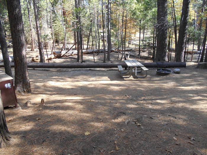
The recreation area offers two developed family campgrounds, a group camp and group picnic shelters. The group campsite can accommodate up to 50 people for tent camping. It is equipped with tables and campfire rings with grills. Accessible vault toilets, showers and drinking water are provided.Group shelters can accommodate up to 150 people. Picnic tables, campfire rings and grills are provided, as well as accessible flush toilets and drinking water. One shelter provides electricity, while the other does not. Each has access to an amphitheater.
Natural Features
The lake sits on Storms Creek, which was dammed in 1939 by the Civilian Conservation Corps. The rugged hills and rock outcroppings offer a scenic backdrop for this beautiful recreation area. The historic Vesuvius iron furnace is located at the base of the dam.Nearby Attractions
The closest town is Ironton, Ohio, less than 10 miles from the campground.LEITH RUN Campground
List of CampsitesOverview
Leith Run Campground provides a beautiful location on the Ohio River, where grassy campsites and picnic areas make for a comfortable getaway in the Wayne National Forest. The campground is equipped with modern conveniences like flush toilets and electricity.
Recreation
The campground provides access to the mighty Ohio River and the Willow Island Pool, where canoeing, kayaking, swimming and fishing are popular activities. A backwater estuary lies alongside the campground.A paved trail and a boardwalk with a gazebo offer not only wildlife viewing opportunities, but also an opportunity to access the estuary and surrounding wetlands area, where fishing is a favorite pastime. Anglers may catch bass, catfish and other species.
Leith Run offers hiking opportunities, group picnic shelters and a playground for kids. A trailhead for the Scenic River Trail, which climbs to a bluff above the river, is available in the campground.
Facilities
Leith Run offers single-family campsites (accommodating up to eight individuals) and group picnic shelters, most of which are accessible. Picnic tables, campfire rings, grills and electric hookups are provided, as are accessible flush toilets, showers and drinking water. A dump station is on-site.An adjacent picnic area, complete with shelters, is equipped with tables, electricity and grills. It also offers a volleyball court, horseshoe pits, scenic overlooks and a playground.
Natural Features
The campground is located on the north banks of the beautiful Ohio River, just miles from the Ohio-West Virginia border, near the town of Newport, Ohio. A scenic hardwood-pine forest covers the campground, which has many waterfront sites.Nearby Attractions
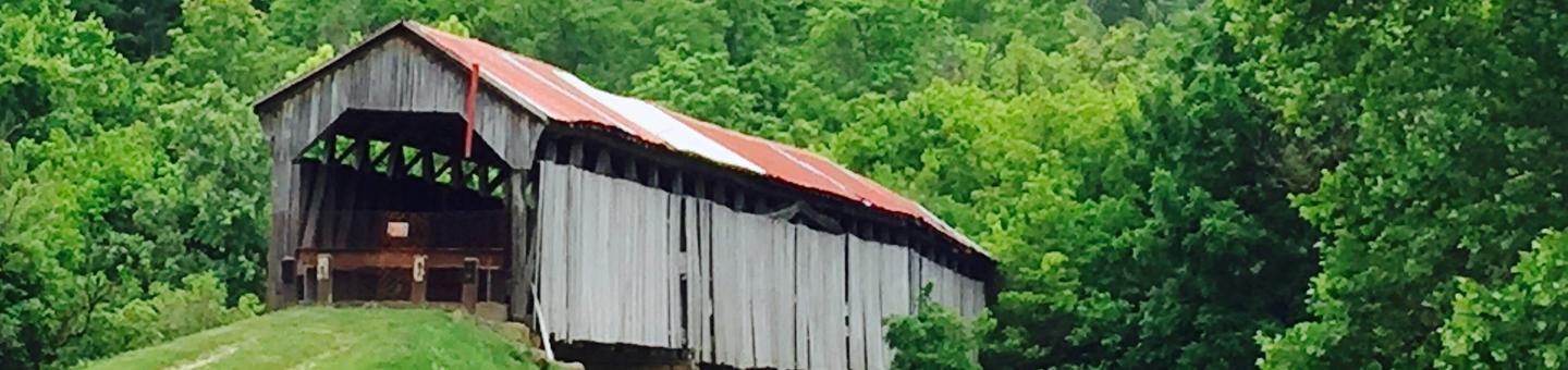
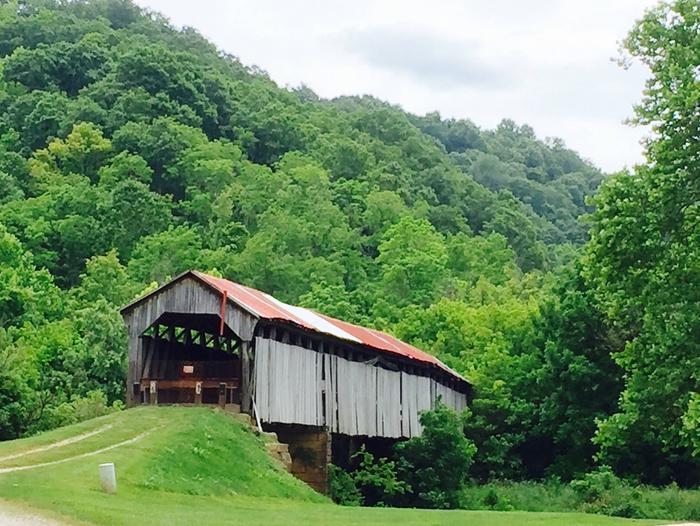
The Covered Bridge Scenic Byway passes by the campground and provides a romantic view of the countryside, complete with forested hills, open pastures and four 19th century covered bridges. Legend has it that it's a tradition for visitors passing over the covered bridges to hold their breath and make a wish.IRON RIDGE - LAKE VESUVIUS Campground
List of CampsitesOverview
Iron Ridge is one of two campgrounds in the Vesuvius Recreation Area in southeastern Ohio's Wayne National Forest. Iron Ridge offers a great location for outdoor recreation, with activities like boating, swimming and fishing on Lake Vesuvius. Horseback riding and hiking are also available in the rolling hills surrounding the campground.Recreation
Boating, fishing and swimming on Lake Vesuvius are the area's most popular activities. Anglers may catch bass, catfish, crappie or bluegill.More than 40 miles of trails exist in the area, with trailheads beginning at or near the campground. A 1/2-mile hiking trail connects the campground to Lake Vesuvius. Lake Shore Trail offers an 8-mile loop around the lake and shorter trails lead to Rock House Cave, a grand, tunnel-like sandstone cave that was once used by Native Americans for shelter.
Facilities
The campground offers multiple sites for RV camping, many of which have electric hookups. Some first-come, first-serve sites are also available. Each campsite can accommodate up to eight individuals.
Each site is equipped with a picnic table and campfire ring with grill. The campground has accessible flush toilets, showers and drinking water. Campsites 9, 19, 20, 21, 23, 24, 25, 26, and 27 all have access to shared water spigots, while all other campsites have their own individual water-hookups. A dump station is located on-site.
Natural Features
Iron Ridge Campground is located on a wooded ridge above 143-acre Lake Vesuvius. A scenic forest of mature eastern hardwoods covers the area.Nearby Attractions
The closest town is Ironton, Ohio, less than 10 miles from the campground.OAK HILL - LAKE VESUVIUS Campground
List of CampsitesOverview
Oak Hill Campground is one of two camping areas within Lake Vesuvius Recreation Area. It has recently renovated and upgraded with modern conveniences like electric hookups and flush toilets. Lake Vesuvius is very close, providing access to ample recreational opportunities.Recreation
Boating, fishing and swimming on Lake Vesuvius are the most popular activities. Anglers may catch bass, catfish, crappie and bluegill.More than 40 miles of trails exist in the area, with trailheads beginning at or near the campground. A spur within the campground connects to the Rock House Trail, which leads to a cave Native Americans used as a hide-out many years ago.
Facilities
The campground offers dozens of accessible single-family sites for tent and RV camping. Each campsite can accommodate up to eight individuals. A group site can accommodate up to 50 people. Some sites are available on a first-come, first-served basis.
Picnic tables, lantern posts, and campfire rings with grills are provided, as well as electric hookups, accessible flush and vault toilets, showers and water hook-ups. A dump station is located on-site.
Natural Features
The campground is situated on the west side of the 143-acre lake. A mixed hardwood-pine forest with many mature oak trees covers the area.Nearby Attractions
The closest town is Ironton, Ohio, less than 10 miles from the campground.Monroe Outlook Facility
This scenic vista provides a 360 degree view of the countryside. It also provides some excellent wildlife viewing opportunities.
The Latitude/Longitude for the site are: N 39° 35' 26.2536"; W 82° 3' 17.7942"
Frontier Boat Launch Facility

This boat launch facility is located in Washington County north of Marietta on State Route 7 along the Ohio River Scenic Byway. The 6 acre site includes 70 parking spaces for trucks and trailers plus additional parking for cars. There ramp is wide enough that two vehicles can launch a boat at one time. The parking area is open all night seven days a week, so overnight parking of vehicles and trailers is allowed.
For a flier with a large map of the area click here (prints best on 11 x 17 but can be printed on smaller paper.)
Dimensions:
- Ramp is 30 feet wide
- Concrete portion with piers is 87 feet long
- Total ramp length is 250 feet long
- 15% slope
Other useful info:
There is good site distance at the launch.
Frontier Boat Launch accesses the Willow Island Pool, bounded by Hannibal Locks & Dam on northern end and Willow Island Locks & Dam on southern end.
Each of the websites below leave the Wayne NF website.
Hannibal Locks & Dam (Pittsburgh District)
Willow Island Locks and Dam (Huntington District)
A $2,247.055 grant was provided by the Ohio Department of Natural Resources, Division of Watercraft through their Cooperative Boating Access Facilities Grant Program to build this facility.
GPS coordinates for this site are: 39 degrees, 28' 1.56" N, 81 degrees, 6' 57.599' W
Arabia Canoe Launch Site Facility
In late 2010, the Wayne National Forest Ironton Ranger District, Ohio Department of Natural Resources (ODNR) Division of Watercraft, and the Symmes Creek Restoration Committee celebrated the opening of the Arabia Canoe Launch located near Arabia along Symmes Creek. Funding for the public launch site came from an ODNR grant and will be maintained in partnership with the Symmes Creek Restoration Committee. There is public parking and a launch ramp available. A grocery store and restaurant are located one mile away on SR 141.
The site is one of six launch sites located along the Art S. Ferguson Canoe Trail, which follows 32 miles of Symmes Creek in Lawrence County from Arabia to the Chesapeake launch on the Ohio River. Launch sites are also available in Aid, Willow Wood, Getaway, Sky Lake, and Chesapeake. Please be respectful to private and public landowners who have granted permission for you to launch from their sites.
Superior OHV System Facility
Superior OHV Trail System is currently 16.5 miles long. A trailhead off State Route 52 accesses this section of trail.
The trail also has two connector trails to the Pine Creek OHV Trail System for continuous riding opportunities and additional traihead access points. The trail system is open to all-terrain vehicles (ATVs), off-highway motorcycles (OHMs), mountain bikes, and hiking. Trail width limit is 50 inches.
Trailhead
Underground Railroad: Vesuvius Furnace Facility
Iron Furnaces, which converted iron ore to pig iron, dotted the northeastern landscape prior to the 19th century. At the turn of the century, the industry developed in the Hanging Rock Iron Region of Ohio and Kentucky which became the largest iron producer in the US.
The Hanging Rock region produced iron from 1818 to 1916 and was one of three in the country capable of producing the iron needed during the Civil War. Not long after the war, the iron boom in Hanging Rock ceased. Hanging Rock’s Vesuvius Furnace, located on today’s Wayne National Forest, is a remnant of 1 of the 46 furnaces in the region.
The iron boom brought in workers who often lived in company towns. Company towns compensated workers with company “money” that could be used only within the town. Ironmasters owned the furnaces and managed company towns.
Ironmasters tended to be abolitionists and often provided support to the Underground Railroad as conductors or station masters. Furnaces and the connecting company towns provided safe havens and financial aid for freedom seekers. Several of the routes used by individuals escaping slavery were along the same paths of Ohio’s iron furnaces.
Black Fork settlement, an iron company town located in Lawrence County, Ohio, employed mostly African Americans, some escaped slaves. However, Black Fork was not a common iron company town; most only served as stations on the Underground Railroad - like Vesuvius - instead of final destinations.
Sources:
US Forest Service, “Vesuvius Furnace,” http://www.fs.usda.gov/detail/wayne/specialplaces/?cid=fsm9_006044
“Iron Furnaces,” http://www.oldindustry.org/iron.html
“Black Fork Settlement, Ohio,” http://www.ohiohistorycentral.org/w/Black_Fork_Settlement,_Ohio
“Historic Iron Furnaces,” http://www.ohio.org/destination/appalachia/historic-iron-furnaces
Underground Railroad and Freedom Trails on National Forests, http://www.fs.usda.gov/detail/wayne/learning/history-culture/?cid=fsm9_006142
This information about the Underground Railroad is part of a geo-located multi-forest interpretive program. Please contact the U.S. Forest Service Washington Office Recreation, Heritage, and Volunteer Resources program leadership with any questions or to make changes. SGV – Recreation Data and Information Coordinator.
Underground Railroad: Payne Cemetery Facility
The Underground Railroad consisted of a large secret network of travel routes and safe havens for freedom-seekers escaping slavery in the mid-19th century. The Ohio River divided freedom and enslavement along several Border States, including Ohio.
Like most states achieving statehood after Congress issued the Northwest Ordinance in 1787 – which forbid slavery in states entering the union north of the Ohio River – Ohio’s population was split between pro-slavery and anti-slavery sentiments. However, its location along the Ohio River meant that there were great opportunities to support the Underground Railroad. By the 1830s, Ohio became a hotbed for Underground Railroad activities. While many freedom seekers passed through Ohio at various entry points, others settled into the state.
Archaeologists and volunteers at the Wayne National Forest, in collaboration with the Friends of Freedom Society, the Multicultural Genealogical Center, and several historically Black Colleges, have focused research on two 19th century African-American settlements. These settlements, Paynes Crossing and Poke Patch, existed primarily from the 1820s to the 1880s. The small homesteads consisted of free Blacks, Whites, and Native Americans. Because of the settlements’ prime locations, both towns most likely served as stations on the Underground Railroad. Only a church and two cemeteries remain today.
___
Paynes Crossing
In the mid-19th century, routes toward freedom for escaped slaves went in several directions on the Underground Railroad. Freedom seekers relied on forests, rivers, and other landscape features for natural paths. Often freedom seekers headed north from slave states through the free state of Ohio. In Ohio, freedom seekers were likely to have come across the free Black community of Paynes Crossing, located in today’s Wayne National Forest.
Paynes Crossing was near New Straitsville, Ohio where farming and the iron industry dominated the landscape. It was a small community established in the 1830s by free Black migrants from Virginia. By the 1850s, African American families owned most of the land.
Research indicates that Paynes Crossing was a logical stop along the Underground Railroad and that the community’s residents were active in aiding freedom seekers. Today, only a cemetery remains as a physical clue about the stories of Paynes Crossing.
Sources:
“Underground Railroad in Ohio,” http://touringohio.com/history/ohio-underground-railroad.html
USDA, US Forest Service, “Underground Railroad and Freedom Trails on the National Forests,” http://www.fs.usda.gov/detailfull/wayne/about-forest/?cid=fsm9_006142&width=full
“The Underground Railroad on the Wayne National Forest” 2014 Brochure, Forest Supervisor’s Office & Athens Ranger District.
For more information on the Payne Cemetery, please visit: http://www.fs.usda.gov/detail/wayne/specialplaces/?cid=fsm9_006031
This information about the Underground Railroad is part of a geo-located multi-forest interpretive program. Please contact the U.S. Forest Service Washington Office Recreation, Heritage, and Volunteer Resources program leadership with any questions or to make changes. SGV – Recreation Data and Information Coordinator.
Ironton Ranger District - Ironton Area Facility
The Ironton Ranger District is located in Lawrence, Scioto, Gallia, and Jackson counties. Total acreage is 107,090 acres. Visitor information can be obtained from the Ironton Ranger Station located north of Ironton, Ohio in Pedro, Ohio.
Athens Ranger District - Athens Area Facility
Located 70 miles southeast of Columbus, Ohio, the Athens Unit of the Athens Ranger District is home to the Wayne National Forest Welcome Center. From here you can learn about all that the Wayne National Forest has to offer and plan your trip.
Monday Creek OHV System Facility
The Monday Creek area of the Wayne National Forest provides some excellent opportunities for riding off-highway vehicles (OHVs). This trail system, north of Nelsonville, provides approximately 75 miles of designated trails to OHV riders, mountain bikers, and hikers. Loading ramps are available at the New Straitsville and White Oak Trailheads.
Trailheads
- Monday Creek Trailhead
- Sycamore Trailhead
- Elm Trailhead
- Scarlet Trailhead
- Red Oak Trailhead
- White Oak Trailhead
- Long Ridge Trailhead
- New Straitsville Trailhead
Monday Creek Trailhead Facility
The Monday Creek area of the Wayne National Forest provides some excellent opportunities for riding off-highway vehicle (OHVs). This trail system, north of Nelsonville, provides approximately 75 miles of designated trails to off-highway vehicle riders, mountain bikers, and hikers. Loading ramps are available at the New Straitsville and White Oak Trailheads.
Old Stone Church Trailhead Facility
This trailhead is part of the Stone Church Horse Trail System.
Named for the skeletal ruins of an old stone church nearby, the Stone Church Horse Trail System provides a great opportunity for scenic riding on 21 miles of trails. Various loops for other distances are available. The horse trail winds through the rolling hills of the Wayne National Forest. The trails will lead you through a variety of vegetation: open fields, brushland, mature forest, and new forest. Along the way, you may glimpse wildlife, and will recognize the influence of humans, both now and in the past. You will also pass many of our land management activities.
Kinderhook Trailhead Facility
This is the Wayne National Forest's newest trail system which provides 12 miles of scenic riding. Horses, mountain bike riders, and hikers are welcome on this trail.The trail winds through some of the steeper hills on the Wayne National Forest. It will lead you through a variety of vegetation: open fields, brushland, mature forest, and new forest. Along the way, you may glimpse wildlife, and will recognize the influence of humans, both now and in the past. You will also pass many of our land management activities.
John's Creek Trailhead Facility
This trailhead is part of the Lake Vesuvius Horse Trail System. The Lake Vesuvius horseback trails system 46.66 miles long and is composed of 9 trails, 4 trailheads, and one horse campground.
The Lake Vesuvius horse trails wind through some of the most striking landscapes in Ohio. They will lead you through a variety of vegetation where many species of wildlife live. You will ride along rock cliffs, water falls, streams and along ridge tops. Expect to see open fields, brushland, mature forest, and young forests. Along the way, you will notice man's influence and land management activities.
Athens Ranger District - Marietta Area Facility
Located in Marrietta, OH, the Marietta Unit serves the southeastern parts of Ohio's Wayne National Forest.
Balancing Rock Trailhead Facility
This trailhead is part of the Lake Vesuvius Horse Trail System. The Lake Vesuvius horseback trails system 46.66 miles long and is composed of 9 trails, 4 trailheads, and one horse campground.
The Lake Vesuvius horse trails wind through some of the most striking landscapes in Ohio. They will lead you through a variety of vegetation where many species of wildlife live. You will ride along rock cliffs, water falls, streams and along ridge tops. Expect to see open fields, brushland, mature forest, and young forests. Along the way, you will notice man's influence and land management activities.
Bluegrass Trailhead Facility
This trailhead is part of the Lake Vesuvius Horse Trail System. The Lake Vesuvius horseback trails system 46.66 miles long and is composed of 9 trails, 4 trailheads, and one horse campground.
The Lake Vesuvius horse trails wind through some of the most striking landscapes in Ohio. They will lead you through a variety of vegetation where many species of wildlife live. You will ride along rock cliffs, water falls, streams and along ridge tops. Expect to see open fields, brushland, mature forest, and young forests. Along the way, you will notice man's influence and land management activities.
Longbow Archery Trailhead Facility
This 0.78-mile archery trail has 25 field targets. The entire trail is barrier free but the first section does have an incline and gravel pathway. Sites 18 through 25 are fully-accessible by federal standards.
The long loop is a 0.62 mile long gravel trail with 18 archery targets, some of which are three-dimensional. The elevation change is less than 40-foot elevation change.
The shorter loop is 0.16-mile and is level, surfaced with crushed limestone, and is designed for accessibility. There are ten archery targets along this segment of trail with bow hangers and benches along the way.
Partners, who helped the Forest Service create this trail were the National Wild Turkey Federation, Lawrence County Bass Club, and B.S.A. Eagles Scouts.
The trailhead is across from the boat dock with the longer trail continuing on from a loop off the shorter trail.
Morgan Sisters Trailhead Facility
This trailhead is part of the Symmes Creek/Morgan Sisters Trail System. The 6 trails in the Morgan Sisters – Symmes Creek Trail System are located in Gallia County, Ohio near Patriot. The trails travel through dense vegetation and over hilly rough terrain with elevation changes of 280 feet. The lowest elevation is 650 feet at Symmes Creek and the highest point is 934 feet on the School House Loop.
Morgan Sisters Trails
The Morgan Sisters Trail System is made up by the Coal Branch, Ridge, and School House loop trails and is located on the west side of Symmes Creek. The Morgan Sisters Trails wind through mature woods with old building sites along the trail. These trails are linked to the two Symmes Creek trails by a short connector trail.
All trails in this trail system are marked with white.
Ohio River Scenic Byway Facility
This byway follows the Ohio River and traverses two of the units (Ironton and Marietta) of the Wayne National Forest. Some of the Forest provides a backdrop to the byway's scenery, in other cases, loop trails off the byway offer visitors alternative routes to explore. A Forest campground along the byway, trails, and other amenities offer byway travelers an opportunity to explore the Wayne.
