
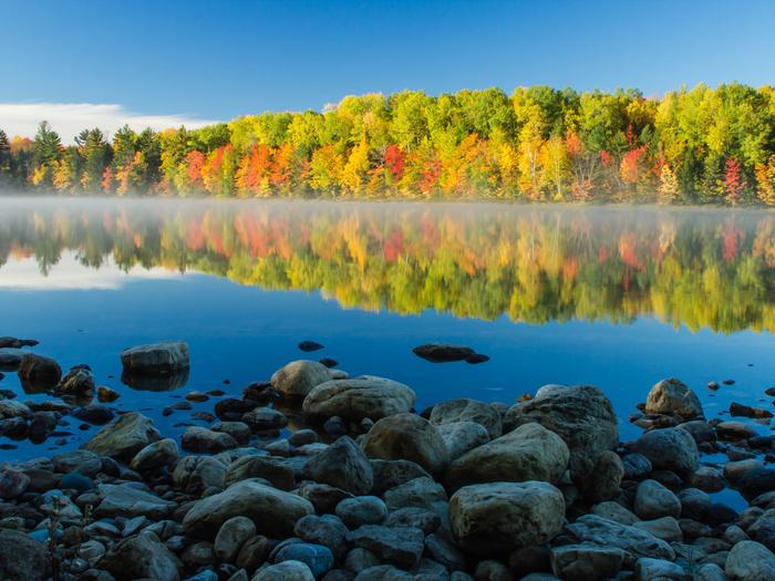
Hiawatha National Forest
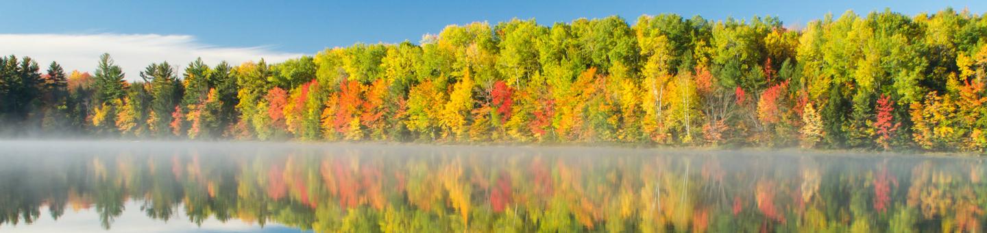
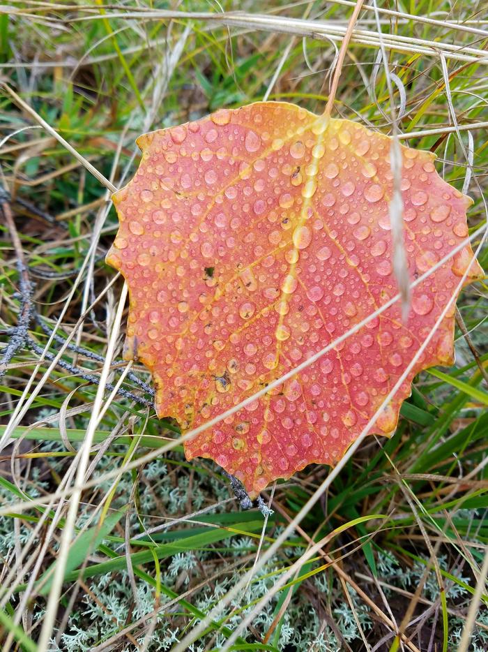
Located in Michigan's wild and scenic Upper Peninsula, the Hiawatha National Forest's dramatic shorelines lie nestled up to Lakes Superior, Huron and Michigan -- three of the five great lakes. Our lake shores, lighthouses, islands and abundant snow create a place of respite and play within a day's drive of urban and rural areas of Michigan, Wisconsin, other nearby states and international locations. Check out these feature stories by visiting this webpage: http://www.fs.usda.gov/detail/hiawatha/about-forest/?cid=STELPRD3808864
RecAreaDirections
Supervisors Office:
820 Rains Drive Gladstone, MI 49837
Phone: 906-428-5800
Open with Google MapMisc
| Stay Limit | |
| Reservable | false |
| Keywords | |
| Map Link | |
| Contact Phone | |
| Contact Email |
Permits info
Facilities
FLOWING WELL CAMPGROUND Campground
List of CampsitesOverview
Flowing Well Campground is situated along the western banks of the Sturgeon River, among large trees and a variety of wildflowers. Camping, fishing, picnicking and canoeing can be enjoyed in a serene setting.Recreation
The area is most popular for canoeing and other non-motorized boating, as the Sturgeon River Canoe Trail runs right through the campground. The trail weaves with the river through a 41-mile portion of the heavily wooded Hiawatha National Forest. There are various access points along the river.Fishing is also popular, with brook trout, steelhead and salmon found in the river.
Facilities
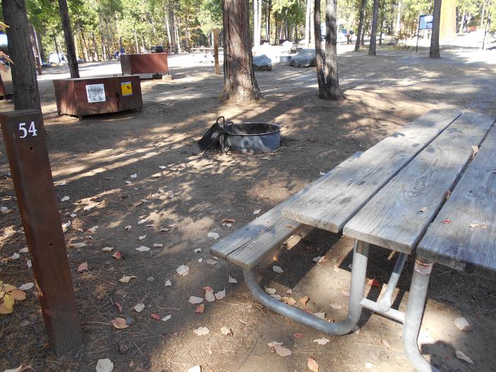
The campground offers less than a dozen spacious sites for tent and RV camping. Some sites are situated along the bank, overlooking the slow-moving river.Each site is equipped with tables and campfire rings, and most come equipped with grills as well. Accessible vault toilets and drinking water are provided. The water from the well has a heavy iron and sulfur content, which is an acquired taste, but is safe to consume.
A group picnic area is also equipped with tables and campfire rings with grills. It is adjacent to a good-sized parking area. Vault toilets and drinking water are also available.
Natural Features
The campground is sandwiched between Forest Highway 13 and the Sturgeon River, in the lower portion of Michigan's Upper Peninsula. It is about 10 miles from the northern shores of Lake Michigan. The region is dotted with wildflowers and mature trees.Little Bay de Noc Campground
List of CampsitesOverview
Little Bay Campground provides a quiet respite from more developed campgrounds in the area. It has long been a favorite for visitors seeking solitude. Beautiful sunsets can be seen over the glistening water of the Little Bay de Noc, and campers enjoy water activities on the lake.Recreation
The bay is widely recognized as one of the finest walleye fisheries in the country. The Hunter's Point paved boat ramp is located less than a mile from the entrance of the campground.Other than fishing, visitors enjoy non-motorized boating and swimming, or simply enjoying the beach. A variety of hiking trails are also within a couple miles of the campground.
Facilities
The campground offers multiple single-family sites and two large group sites, available for tent and RV camping. Each site is equipped with tables and campfire rings with grills. Accessible vault toilets and drinking water are also provided.A day-use picnic area is equipped with tables and grills. An adjacent open grassy area is available for large recreational gatherings. The picnic area is also adjacent to the swimming beach and boat ramp.
Natural Features
The campground sits on the shore of Little Bay de Noc, on the north end of Lake Michigan. A group camping area is separated from the other sites with oak, hemlock and hardwood trees, providing a relatively private camping experience.CAMP SEVEN LAKE CAMPGROUND Campground
List of CampsitesOverview
Camp Seven Lake Campground neighbors the 60-acre Camp Seven Lake, which offers visitors a place to swim, boat and fish. The excellent location, beautiful setting and many available activities make the campground a perfect place to spend a day, the weekend or longer vacation.Recreation
Boating is popular among visitors to the Camp Seven Lake area, and anglers looking to find that perfect spot on the lake. Smallmouth bass, bluegills and perch make up the most popular catches.The 2-mile Van Winkle Lake loop trail leads hikers to a spectacular paper birch stand overlooking quiet Van Winkle Lake. A variety of waterfowl and wetland wildlife can be spotted along the trail. For a more relaxing stroll, the beach at Camp Seven Lake boasts a paved walking trail.
Facilities
The campground offers multiple accessible single-family campsites, available for tent and RV camping. For the most part, each site is shaded and private and some are right on the lake. A few sites are available on a first-come, first-served basis.Each site is equipped with tables and campfire rings; only a few have grills. Accessible vault toilets and drinking water are provided. A group picnic area can accommodate up to 25 people and offers tables, a campfire circle and a grill.
Natural Features
The campground is adjacent to Camp Seven Lake, which is situated in the lower third of the Hiawatha National Forest, in Michigan's Upper Peninsula. The area is home to many bodies of water and plentiful mixed hardwood forests.Nearby Attractions
The town of Garden Corners is about 20 miles from the campground, on the shores of Lake Michigan.COLWELL LAKE CAMPGROUND Campground
List of CampsitesOverview
Colwell Lake Campground is situated on Colwell Lake in the center of Michigan's Hiawatha National Forest. Guests of all ages can enjoy nature and the outdoors in this picturesque setting.The campground has much to offer in terms of recreation, such as swimming, fishing, boating and picnicking, and can accommodate families, individuals, small groups, RV and tent campers with several amenities.
Recreation
With an excellent swimming beach, boat access and an accessible fishing pier, Colwell Lake has plenty to offer families and anglers.Largemouth bass, northern pike, crappie, pumpkinseed sunfish, perch and bluegill are all available in the lake. The facility also provides a leisurely 2 mile hiking and snowshoeing trail.
Facilities
The campground consists of many individual family sites, as well as a group site that can hold 24 people and two tent-only sites along the lake shore. Sites are equipped with campfire rings, lantern posts and tent pads, with vault toilets and drinking water located throughout the facility.A picnic area sits adjacent to the sandy swimming beach. Pedestal grills and tables for individual families or small groups are provided.
Boaters will find a boat ramp and launching pier near the campground entrance. There is adequate space for parking and a trailer turn-around.
Natural Features
The campground is situated on Michigan's Upper Peninsula, on the eastern shore of the 145-acre Colwell Lake. The area is forested with a variety of deciduous and conifer trees, and some campsites overlook the water.Nearby Attractions
Big Island, Fish and Straits lakes are all within 25 miles of the campground.Au Train Lake Campground Campground
List of CampsitesOverview
Located at the south end of AuTrain Lake, this campground is favored by anglers and outdoor enthusiasts.The quiet setting is great for family trips, and visitors can enjoy a variety of recreational opportunities year-round, all less than a day's drive from major urban areas of Michigan and Wisconsin.
Recreation
The large size of the lake provides miles of prime water skiing, boating, swimming and fishing. Anglers can expect a healthy catch of bass and a variety of perch. Canoeing is also popular on AuTrain Lake and the nearby AuTrain River, which meanders into Lake Superior.The campground also provides access to the popular two-mile Songbird interpretive trail, which winds through forest and field, along bog and lakeshore, and is popular for birding.
A wildlife viewing platform is available at neighboring Buck Bay and Buck Bay Creek.
Facilities
The campground offers dozens of large, wooded campsites, available for tent and RV camping. Some sites are available on a first-come, first-served basis. Each site is equipped with tables and campfire rings with grills. Accessible vault toilets and drinking water are provided.A boat ramp is available at the parking area of the campground, and the lot offers plenty of space for turning and parking. Boat rentals are available in AuTrain.
Natural Features
AuTrain Lake is located in the upper peninsula of Michigan, between three of the Great Lakes. It sits amid rolling hills forested with pine and aspen trees, as well as large open and tree-covered wetlands.Nearby Attractions
The city of AuTrain, located on the shores of Lake Superior, is about 5 miles from the campground.BAY FURNACE CAMPGROUND Campground
List of CampsitesOverview
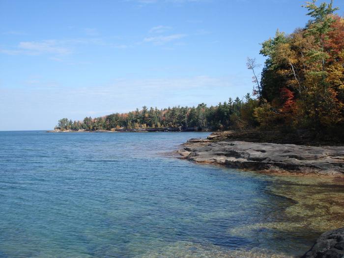
Bay Furnace Campground is located on the south shores of Lake Superior, near Pictured Rocks National Lakeshore. Favorite to many, the campground is centered to various waterfalls, as well as other sightseeing attractions, including boat tours and visits to Grand Island.Recreation
Fishing in Lake Superior is best by boat. There is no access to the lake at Bay Furnace, but there is a boat ramp approximately 10 miles west, at AuTrain, and in Munising. Anglers can enjoy a variety of lake trout and salmon fishing.Visitors can access the popular Grand Island via a 10-minute ferry ride or by private boat. This scenic island is a favorite for hiking, mountain biking and exploring.
Various boat excursions are offered near the campground at an additional cost, providing a great way to explore the crystal clear blue-green waters of Lake Superior and view the stunning natural rock formations.
Facilities
The campground offers multiple reservable single sites for tent and RV camping. Additional campsites are available on a first-come, first-served basis. Each site is equipped with tables and campfire rings with grills. Accessible vault toilets and drinking water are provided.A day-use picnic area is also available at the campground, located near the lake shore. Multiple tables, drinking water and accessible vault toilets are included.
Natural Features
Visitors can enjoy the scenic views of Lake Superior, with its spectacular sunrises, sunsets and occasional northern lights displays. Amid forests of deciduous trees, some sites overlook the lake while others are near Furnace Creek.Nearby Attractions
Boat ramps are available in Munising, less than 5 miles from the campground, or at AuTrain, which is about 10 miles away.Pete’s Lake Campground Campground
List of CampsitesOverview
Petes Lake Campground, located in the center of Michigan's Hiawatha National Forest, is surrounded by several lakes and offers excellent hiking, biking, fishing, boating and more.Snuggled amongst mixed hardwood trees, the campground offers a swimming beach and day-use picnic area away from the hustle and bustle of city life.
Recreation
Visitors enjoy a variety of water-related recreation opportunities. The campground also has fishing pier next to the day-use area. Anglers can expect healthy populations of northern pike, bass, walleye and perch in the lake.The nine-mile Bruno's Run Trail, which winds its way past a host of small lakes in the area, passes directly through the campground and is a popular trail for hiking and biking, as well as snowshoeing and cross-country skiing in the winter.
Facilities
The campground offers multiple spacious and forested private campsites for tent and RV camping. A few sites overlook the lake.Each site is equipped with tables and campfire rings and about half of the sites have access to a grill. Accessible vault toilets and drinking water are provided.
A shaded day-use picnic area at the campground offers multiple tables and benches right on the lake shore. Accessible vault toilets and drinking water are also provided in the picnic area, as well as a fairly large parking area.
Natural Features
The campground is situated on the upper peninsula of Michigan, on the shores of the 190-acre Petes Lake. It sits amid rolling hills that are forested with a variety of deciduous and conifer trees. Many of the campsites are shaded and private.Nearby Attractions
Big Island, Fish and Straits lakes are all within 25 miles of the campground.Council Lake Campsites Campground
List of CampsitesOverview
There are many campsites on the Munising and Rapid River/Manistique Ranger Districts of the Hiawatha National Forest. Many are located on inland lakes and are in a rustic forest environment with few to no amenities and no drinking water. The rustic environment offers a wonderfully serene and peaceful setting for your next camping experience.
The Council Lake Campsites sit on the shores of Council Lake in the center of the Hiawatha National Forest.
It is located amid a series of forested lakes and provides ample opportunity for visitors to enjoy nature in the scenic surroundings.
Recreation
Council Lake is a 12-acre lake with yellow perch, rock and largemouth bass, bluegill, black crappie, bullhead and northern pike. Licenses are required to fish in Michigan waters.
Council Lake is part of a small chain of lakes and offers excellent canoeing and kayaking opportunities. There is a short portage that links Council Lake to Bar Lake and the Indian Wild and Scenic River.
Non-motorized boats can be used on the lake, however access at the campground is by land only. A boat ramp can be found at adjoining Red Jack Lake.
The day-use area is equipped with tables and a campfire ring with a grill. The area is near a beach that is perfect for lounging and swimming. No drinking water is provided at the campsite; water must be brought in and garbage must be carried out.
Facilities
There are four campsites at Council Lake for tent and small RV camping. Each campsite is equipped with a table and a campfire ring. A pit toilet is located near site 1, but toilet paper is not provided.
There is NO drinking water.
Lake Name: Council Lake
Number of Sites: 4
Maximum Number of People: 8 (for each site)
Toilets: 1 (by site 1)
Boat Access: Carry-In
Lake Size (acres): 14
Natural Features
These campsites are situated on the quaint 12 - acre Council Lake, nestled in a mixed stand of hardwood and pine trees. They are on the southern shores of Council Lake, close to adjoining Red Jack and Scout lakes.
contact_info
For local information, please call (906) 387-2512 or call (906) 474-6442 for general information.Cookson Lake Campsites Campground
List of CampsitesOverview
There are many campsites on the Munising and Rapid River/Manistique Ranger Districts of the Hiawatha National Forest. Many are located on inland lakes and are in a rustic forest environment with few to no amenities and no drinking water. The rustic environment offers a wonderfully serene and peaceful setting for your next camping experience. All of these sites are nestled in hardwood trees and pines. All of them are on small inland lakes, which offer a wide variety of fishing opportunities.
Recreation
Visitors enjoy swimming and fishing in the 35-acre adjacent lake. Largemouth bass, northern pike, bluegill and bullhead are among the typical catch. Licenses are required for fishing in Michigan waters.
A public boat ramp is located adjacent to site 2, which can be used to access Cookson Lake's fishery of largemouth bass, northern pike, bluegill and bullhead.
Facilities
The campground offers five primitive campsites for tent and RV camping. Each offers tables and campfire rings. A pit toilet is located near one of the sites, but toilet paper is not provided.
Drinking water is NOT present at these sites.
There is a primitive toilet present at these sites.
Lake Name: Cookson Lake
Number of Sites: 5
Maximum Number of People: Site 1 (8), Sites 2-5 (16)
Toilets: 1
Boat Access: Back-In
Lake Size (acres): 35
Natural Features
Cookson Lake Campsite offers a primitive place to stay in the thick of Michigan's wilderness. Beautiful forests surround several lakes in the area, providing ample opportunity to enjoy nature in all its forms.
These campsites is located in a large open field on the shores of Cookson Lake. All of the campsites are surrounded by a mixed stand of aspens and northern hardwoods on the south shore of the lake. This 35 - acre lake boasts two small islands, and a variety of wildflowers abound in the area during warmer months.
Nearby Attractions
Cookson Lake is near the Indian Wild and Scenic River and the Big Island Lake Wilderness Area.
Groceries, ice, gasoline, fishing and camping supplies, ice and deli are available 5 miles east on County Road 437 in the Steuben Area.
contact_info
For local information, please call (906) 387-2512 or call (906) 474-6442 for general information.Ewing Point Campsite Campground
List of CampsitesOverview
There are many campsites on the Munising and Rapid River/Manistique Ranger Districts of the Hiawatha National Forest. Many are located on inland lakes and are in a rustic forest environment with few to no amenities and no drinking water. The rustic environment offers a wonderfully serene and peaceful setting for your next camping experience. All of these sites are nestled in hardwood trees and pines. All of them are on small inland lakes, which offer a wide variety of fishing opportunities.
Recreation
Visitors will be able to enjoy swimming, berry picking, and fishing at these dispersed campsites. Licenses are required for fishing in Michigan waters.
Bruno's Run Hiking Trail weaves throughout the Ewing Point area, offering 9 miles of adventure for hikers. The trail is accessible at various locations, two of which are near the Ewing Point parking area. One section of the trail leads to Grassy Lake, while the other heads along the southeastern portion of McKeever Lake.
McKeever Lake offers great fishing for musky, pike, bass and pan fish, and there is boat access in the parking area. Boats must be carried to the site by hand or through the water. Because the water is quite shallow, large boats are not recommended.
The lake bottom is sandy and provides good wading opportunities. Be cautious when swimming because this area has not ben checked for possible hazards - swimming is at your own risk.
Facilities
There is NO drinking water at the site. Drinking water must be carried in. Water is available at Pete's Lake Campground.
There is a pit toilet available.
The campsite is equipped with tables, a campfire ring with a grill and a lantern post.
Lake Name: McKeever Lake
Number of Sites: 1
Maximum Number of People Per Site: 16
Toilets: 1
Boat Access: Back-In
Lake Size (acres): 132
Natural Features
Ewing Point is a beautiful walk-in campsite located on the north side of the 132-acre McKeever Lake. The grassy site is 50 ft x 75 ft, surrounded by hemlock and cedar.
contact_info
For local information, please call (906) 474-6442 or call (906) 387-2512 for general information.BREVOORT LAKE CAMPGROUND Campground
List of CampsitesOverview
Brevoort Lake Campground stretches along the western shore of its namesake in the Hiawatha National Forest. This popular fishing destination is situated on a peninsula that juts into the lake and Beodne Bay. Visitors to the campground enjoy the easy access to the pristine sandy beaches.Recreation
The 4,233-acre Brevoort Lake provides ample opportunities for recreation. Boat access is available from the center of the campground on Boedne Bay.In 1985, the Forest Service completed the construction of a walleye spawning reef in Brevoort Lake, providing plentiful fishing in the area. Anglers can also expect healthy populations of pike, bass, perch and a variety of other fish.
Hiking is also a popular pastime of visitors to the campground. The Ridge, Sand Dunes Cross Country and North Country National Scenic trails pass near the campground.
A 10-minute ferry ride to Mackinac Island makes for an interesting day trip. The 3.8-acre island offers hiking, biking, horseback riding and shopping, as well as access to historical sites and museums, among other activities.
Facilities
The campground offers dozens of reservable single-family campsites for tent and RV camping. Additional sites are available on a first-come, first-served basis. Each site is equipped with tables and campfire rings with grills, and accessible flush toilets, drinking water and a dump station are provided.Natural Features
Campsites are somewhat secluded, surrounded by huge pine, hemlock and oak trees and low, shrubby vegetation. Beach grass grows along the lake shore, sometimes buried in light sand.Nearby Attractions
St. Ignace, Michigan, about 20 miles east of the campground, offers historical and tourist attractions as well as grocery and gas services.Charges & Cancellations
Please cancel 7 days in advance if you need to cancel your reservation. Reservation sites cannot be traded for walk-up sites.
LAKE MICHIGAN AT ST. IGNACE Campground
List of CampsitesOverview
Lake Michigan Campground at St. Ignace provides great views and unlimited access to Lake Michigan. The area has excellent trails, winding hikers through ancient sand dunes, windswept foundations and a variety of vegetation.Recreation
The campsites are located between 20- to 30-foot high sand dunes and are just steps away from great body-surfing waves, that crash onto the lake's sandy beaches during commonly high winds. Lake Michigan does offer fishing, but anglers tend to prefer Brevort Lake better, for its catches of walleye, pike, bass, perch and crappie. Campers at Lake Michigan have access to the popular Sand Dunes Cross-Country Ski Trail, as well as the North Country National Scenic Trail, which connects a host of natural areas, from valleys to hilltops, prairies to forests and everything in between. Both trails offer miles of terrain, keeping hikers busy for as long as they choose.Facilities
The campground offers many shaded and open sites for tent and RV camping. Some sites are available on a first-come, first-served basis. Picnic tables and campfire rings with grills are provided.Accessible vault toilets are available, as well as drinking water. Hookups are not provided. Parking spurs are comprised of grass and dirt. A trash collection bin is available at the campground and a dump station can be found at Brevort Lake.
Natural Features
The campground stretches along a bluff between the highway and the lake. Dunes, waves, sand and wind are the primary environmental factors present. Visitors enjoy watching shorebirds, like the Spotted Sandpiper, which can often be seen running up and down the beaches throughout the day.Nearby Attractions
Brevort Lake is about five miles from the campground. St. Ignace is about 18 miles from the campground and is the closest town.Charges & Cancellations
Please cancel 7 days in advance if you need to cancel your reservation. Reservation sites cannot be traded for walk up sites.
CARP RIVER CAMPGROUND Campground
List of CampsitesOverview
Nestled in a quiet, rustic setting adjacent to the Carp Wild and Scenic River, Carp River Campground is an ideal place to get away and enjoy the outdoors.The surrounding Hiawatha National Forest provides visitors with countless recreational activities, and the scenery provides a beautiful backdrop for a traditional camping experience.
Recreation
Divided into two major blocks of land and five districts, the forest is home to Grand Island National Recreation Area, Whitefish Scenic Byway, six lighthouses, five Wildernesses and Clear Lake Education Center. In addition to recreation opportunities, visitors will find a wide array of habitats, including trees like northern hardwoods, jackpine and other conifers, and a variety of inland wetland habitats.Fishing is a popular activity in the campground area, and brook, brown and rainbow trout can all be spotted in the Carp River.
In addition to the fishing opportunities, hiking canoeing, kayaking, wildlife viewing and more are all available at or around the Carp River Campground.
Facilities
All campsites are wooded and shaded from the hot summer sun. Each site has a table and a fire ring, and drinking water and vault toilets are conveniently spaced throughout the campground.Natural Features
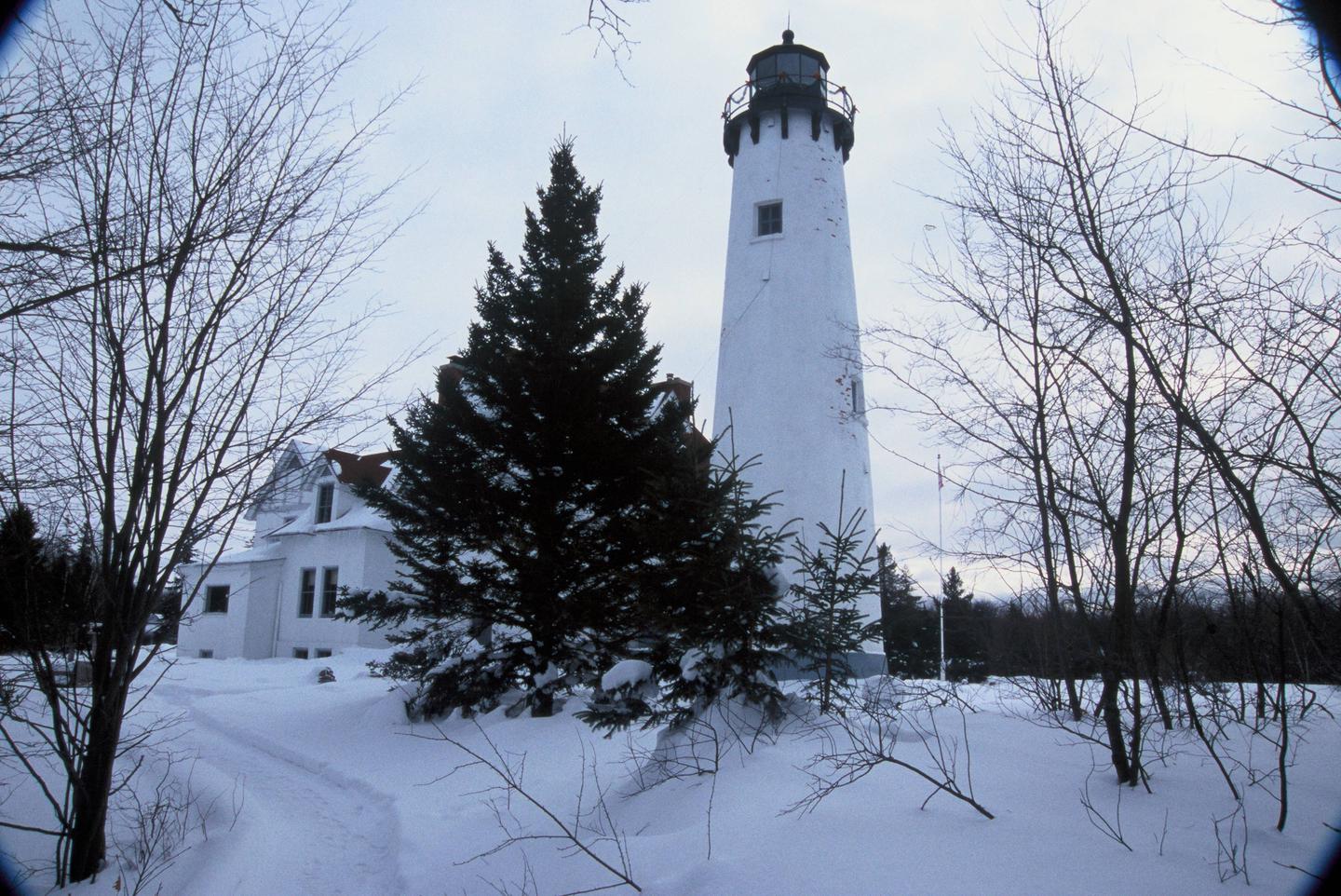
Located in Michigan's wild and scenic Upper Peninsula, the Hiawatha National Forest is known as "the Great Lakes National Forest." The forest's dramatic shorelines lie nestled up to Lakes Superior, Huron and Michigan.Outstanding lakeshores, lighthouses, islands and historic sites create a playground and place of respite, all within a day's drive from major urban and rural areas of Michigan and Wisconsin.
Nearby Attractions
Carp River Campground is located just eight miles from St. Ignace, which is known for its fine restaurants, museums and historic sites.Charges & Cancellations
Please cancel seven days in advance if you need to cancel your reservation. Reservation sites cannot be traded for walk up sites.
MCKEEVER CABIN Campground
List of CampsitesOverview
McKeever Cabin is located in the Hiawatha National Forest in Michigan's Upper Peninsula, approximately 14 miles south of Munising, Michigan. The Cabin was constructed in 1991 and overlooks the 132-acre McKeever Lake.While the facility offers little in the way of modern amenities, convenient access to a number of recreational activities, including hunting, fishing, hiking, mountain biking, swimming and cross-country skiing, make this cabin a desirable destination for the outdoors enthusiast.
During warmer months, visitors may park their vehicle and access the cabin by foot via a 1,000 ft. trail. When snow is present, the cabin may be accessed by snowshoe or cross-country skis via a 1-mile trail.
Recreation
During winter months, visitors can enjoy the McKeever Hills Ski Trail, which offers a quieter, less manicured alternative to highly groomed trails without sacrificing quality. The trail to the cabin connects directly to the ski trail, so visitors can ski right out the cabin door.The Bruno's Run Trail offers a 9 mile (14.48 km) loop ideal for hiking and mountain biking in spring, summer and fall and snow shoeing in winter. Although the trail is not groomed for cross-country skiing, it does offer a suitable source for experienced skiers who prefer to break their own way.
Seasonal activities also include swimming, canoeing, kayaking and fishing on the lake as well as hunting in designated areas. See the Michigan Department of Natural Resource's website for information about hunting seasons and permits.
Facilities
The cabin can accommodate up to four people comfortably and a maximum of six people. There are two sets of bunk beds (with 4 mattresses), one table with stools, one counter top, one corner seat and a wood burning stove. There is no longer a loft with a mattress in this cabin. There are no modern bathroom facilities or electricity offered at this cabin. In order to ensure a comfortable stay, visitors must bring several of their own supplies including a camp stove, dishes, cooking utensils, containers for carrying water, toilet paper, lanterns, sleeping bags and pillows. A vault toilet is located just off the trail to the cabin and there is a (summer/winter) hand pump with drinking water located down the trail to the lake. Do not bring firewood from home: firewood will be supplied at the cabin.Natural Features
The cabin is situated on a small knoll surrounded by young evergreens and hardwood trees, overlooking the western shores of McKeever Lake. The lake was stocked with northern muskie in 1990, but also supports a good population of northern pike, largemouth bass, smallmouth bass and bluegill.The Big Island Lake Wilderness is located near the cabin and features 23 small lakes ranging in size from 5 to 149 acres. White birch, maple and aspen cover the wooded hills that surround the lakes. Berries, mushrooms and wildflowers grow throughout the area and a wide range of wildlife and waterfowl, including sensitive species, may be carefully observed here.
contact_info
For local information, please call (906) 387-2512 or call (906) 474-6442 for general information.SOLDIER LAKE Campground
List of CampsitesOverview
A quiet, relaxing campground with campsites nestled in the pines surrounding Soldier Lake in Michigan's Upper Peninsula. The campground provides a feeling of remoteness but is still close to roads that lead to some of the best sightseeing the area has to offer.Recreation
Non-motorized boating is allowed on Soldier Lake. Swimming is also a popular activity. Two sandy beaches are found within the campground and day use areas. The North Country National Scenic Trail, which winds through several northern states, can be accessed from the day use area.Facilities
The rustic campground offers shaded single-family sites for tent and RV camping. Each site is equipped with a table and a campfire ring. Vault toilets and drinking water are provided. No hookups are available. The campground also has two large day-use picnic areas with tables and grills. A sheltered picnic area is equipped with a fireplace. The picnic area has vault toilets and drinking water.Natural Features
The campground surrounds 15-acre Soldier Lake. A scenic forest of pine, aspen and maple trees covers the area.Nearby Attractions
The closest town is Strongs, 7 miles west. Services available include a fuel station, restaurants, and a general store.Charges & Cancellations
Please cancel 7 days in advance for reservation sites. Reservation sites cannot be transferred to walk-in sites.
Bay View (Hiawatha National Forest, MI) Campground
List of CampsitesOverview
Located just off the Whitefish Bay Scenic Byway in Michigan's Upper Peninsula, Bay View Campground provides a rustic opportunity to camp along the shores of Lake Superior. The campground is a perfect stop amidst many recreational opportunities available in the Sault Ste. Marie area. Visitors also enjoy exploring the Whitefish Bay National Scenic Byway all the way to the beautiful Tahquamenon Falls.Recreation
Miles of sandy beaches and beautiful sunsets stretch across Lake Superior, the greatest single body of fresh water in the world. Birding and sightseeing are popular pastimes, and visitors enjoy long walks along Superior's beaches.Facilities
The rustic campground offers multiple single-family campsites for tent and RV camping. Each site is equipped with a picnic table and campfire rings with grills.Vault toilets and hand-pumped drinking water are available at several locations within the campground. Most of the sites are heavily shaded. A campground host lives at the campground and can be available to answer any questions.
Natural Features
The campground is located in Lake Superior's famous Whitefish Bay, the site of numerous historically preserved shipwrecks and lighthouse stations. The area is also a natural corridor for migratory birds.Nearby Attractions
Tahquamenon Falls, a series of beautifully brown-colored waterfalls on the Tahquamenon River, are located just 30 miles away. The Great Lakes Shipwreck Museum and Whitefish Point Lighthouse are 39 miles to the north and west while the Point Iroquois Lighthouse lies about 8 miles east.Charges & Cancellations
Please cancel 7 days in advance if you need to cancel your reservation. Reserve sites cannot be transferred to walk up sites.
MONOCLE LAKE Campground
List of CampsitesOverview
Monocle Lake Campground offers a a relaxing place to fish, swim and hike along the shores of scenic Monocle Lake just off Lake Superior. It is located in Michigan's Upper Peninsula in the northeastern corner of the Hiawatha National Forest.The campground is centrally located among many recreational opportunities in the Sault Ste. Marie area, including the Whitefish Bay National Scenic Byway and Tahquamenon Falls.
Recreation
Monocle Lake is populated with walleye, smallmouth bass, pike and perch. Two man-made reefs lie just off the eastern shore next to the campground, where anglers typically have good luck.Swimming and boating are popular activities in the area. Visitors also enjoy hiking the 14.5-mile Monocle Lake Trail. Two miles of the trail have interpretive displays, and the first 1100 feet of the trail are along an elevated, accessible boardwalk. Additional trails are found in the surrounding area.
Facilities
The campground offers heavily shaded single-family sites for tent and RV camping. Some sites are available on a first-come, first-served basis. Each site is equipped with a table and campfire ring with grill. Accessible vault toilets and drinking water are provided. Hookups are not available.A day-use picnic area, adjacent to a fairly large parking area at the campground, provides easy access to a swimming beach. The picnic area is equipped with tables, grills and drinking water, as well as accessible vault toilets. A paved boat launch with a parking lot big enough to accommodate vehicles and trailers provides easy access to the beautiful all sports lake.
Natural Features
The campground surrounds the south end of 172-acre Monocle Lake, and is less than two miles from the historic Point Iroquois Lighthouse. It is nestled in a mixed hardwood forest of aspen, maple, birch and pine trees, providing scenic lake and forest views from anywhere in the campground. Private residences also surround the inland lake.Nearby Attractions
The nearest town is Bay Mills, which is about 6 miles from Monocle Lake. The United States-Canada border, at Sault Ste. Marie, is about 25 miles from the campground.Tahquamenon Falls, a series of beautifully brown-colored waterfalls on the Tahquamenon River, is located about 35 miles from Monocle Lake.
Charges & Cancellations
Please cancel 7 days in advance if you need to cancel your reservation. Reservation sites cannot be traded for walk-in sites.
THREE LAKES Campground
List of CampsitesOverview
Three Lakes Campground is a peaceful facility tucked away from the busy highway. It is nestled between Whitmarsh, Brown and Walker Lakes, giving visitors ample opportunity to enjoy and explore nature at its best.Recreation
The three lakes are open to non-motorized boating. A carry-down boat ramp is located at the campground's picnic area. Fishing is a popular activity. Rainbow trout, perch and catfish are found in the lakes. Although there is no designated swimming beach, sandy areas are located along the shores of the three lakes.Hikers enjoy the serene atmosphere of the campground. The Walker Loop Trail begins within the campground, near the picnic area, and leads hikers around the perimeter of Walker Lake. The trail is easy hiking and traverses about 1.15 miles.
Facilities
Three Lakes Campground is a rustic campground with single-family sites for tent and RV camping. Each is equipped with a table and campfire ring. Vault toilets and drinking water are provided. A day-use picnic area is also available.Natural Features
The campground is set among a variety of pine, spruce and maple trees on land sandwiched between Lake Superior and Lake Michigan. Whitmarsh, Brown and Walker Lakes dot the landscape to the north, south, and west of the campground.Nearby Attractions
The nearest town is Strongs, just 2.5 miles from the campground.MURRAY BAY GROUP CAMPSITE on GRAND ISLAND Campground
List of CampsitesOverview
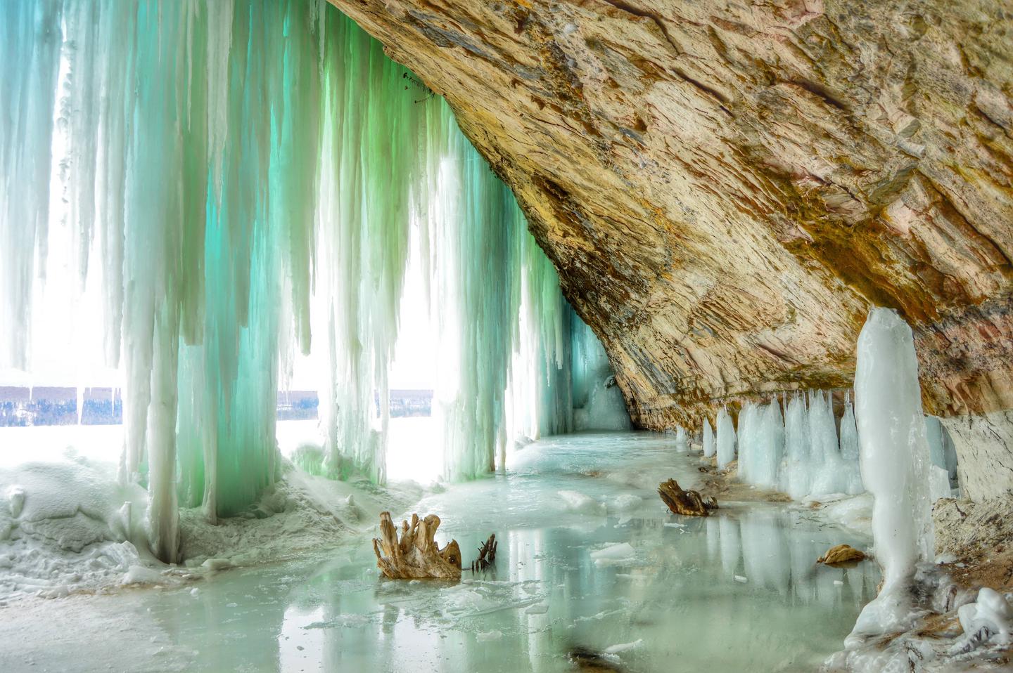
Murray Bay Group Campground is located on the southern shores of Grand Island, at the southeastern tip of Lake Superior. The island's scenic natural beauty and interesting history make it an attractive place for camping and other outdoor activities.The Grand Island National Recreation Area boasts massive 300-foot wave-cut sandstone cliffs, 13,500 acres of lush forest, beaches of fine sand, winter ice caves and historic buildings and artifacts dating back as far as 2000 B.C.
Recreation
The sandy lake is a popular swimming destination. Boating is also available, however, there is no boat ramp or dock facility at the campground.Anglers and hunters frequent the area for its wide variety of fish and game. Licenses are required to participate in either activity.
Visitors also enjoy over 30 miles of hiking and mountain biking trails on the island. A bus tour is also available for those who would like to learn more about the island's natural and cultural history.
Facilities
The campground offers a single group campsite that can accommodate up to 25 guests, as well as a day-use picnic area. Both are equipped with tables and campfire rings with grills.Vault toilets and drinking water are also provided. Camping is not allowed at the day-use site. A bear pole and box for food storage are provided at each site.
Natural Features
Grand Island and the Murray Bay Group Campground are part of the Hiawatha National Forest, near Michigan's Upper Peninsula. Calm waters and white-sand beaches beckon boaters and swimmers to the area.JUNIPER FLATS GROUP CAMPSITE on GRAND ISLAND Campground
List of CampsitesOverview
Juniper Flats Group Campground is one of only a few places to stay on beautiful Grand Island. The island's scenic natural beauty and interesting history make it a popular place for camping and other outdoor activities.The Grand Island National Recreation Area boasts massive 300-foot wave-cut sandstone cliffs, 13,500 acres of lush forest, beaches of fine sand, winter ice caves and historic buildings and artifacts dating back as far as 2000 B.C.
Recreation
The island offers more than 30 miles of hiking and mountain biking trails, complete with spectacular scenery. Visitors also enjoy fishing on the island. Anglers will find plentiful salmon, trout, perch, pike, walleye and bass. A variety of wildlife also make its home on the island.Kayaking, canoeing and boating are also popular pastimes. Boats, however, must be anchored offshore because of the rocky lake bottom and heavy surf.
Facilities
The campground provides one large group tent campsite, equipped with tables and a campfire circle. Vault toilets and drinking water are provided. Bear poles and bear boxes are available for food storage.Natural Features
Juniper Flats Group Campground is located on the west side of Grand Island near the Waterfall and Mather beaches.The area is heavily forested and primarily shady throughout the day. The campground is situated away from the beach, but the lake is visible from the site.
WIDEWATERS CAMPGROUND Campground
List of CampsitesOverview
Widewaters Campground is remotely located on Michigan's upper peninsula in the Hiawatha National Forest.It sits on a stretch of heavily forested land between Lake Superior and Lake Michigan, near a series of smaller lakes and the Indian River, making it an ideal getaway for anglers and explorers alike.
Recreation
This small, quiet campground is perfect for fishing, canoeing and kayaking. Anglers enjoy catching brook trout in the area.The 9-mile Bruno's Run Trail, which winds its way past a host of small lakes in the area, passes directly through the campground and is a popular trail for hiking and biking, as well as snowshoeing and cross-country skiing in the winter.
Facilities
The campground offers multiple well-spaced single-family sites, available for tent and RV camping. Sites vary from being heavily wooded and private, to open with little privacy. A few waterfront sites have access to the river. Some additional sites are available on a first-come, first-served basis.Each site is equipped with tables and campfire rings and some have access to grills. Accessible vault toilets and drinking water are provided.
Boat ramps are available at the campground and also at Fish Lake.
Natural Features
Widewaters is in a beautiful forest of mature hardwoods, sandwiched between Irwin Lake and Indian River.TOM'S LAKE CABIN Campground
List of CampsitesOverview
Tom's Lake Cabin was built in 1991 and will accommodate up to eight people. The cabin is situated on a small knoll overlooking Tom's Lake, a 23 acre lake in the heart of the Hiawatha National Forest.Recreation
There are several hiking, biking, and horseback riding trails within a few miles from the cabin, including the Ironjaw semi-primitive area and the Pine Marten Run trail system offering 26 miles of trail. For the winter enthusiast, snowmobile trails can be found nearby, and the Pine Marten Run trail is frequently used for snowshoeing and cross-country skiing (although the trail is not groomed). Those trying their hand at fishing on the lake should note that boat access is carry-in only.Facilities
The cabin has a wood stove and firewood is provided in addition to the pedestal grill and fire pit outside. The cabin does not have modern bathroom facilities or electricity. There is a hand pump for drinking water just outside the cabin and a pit toilet behind the cabin. The cabin is furnished with four twin bunk beds with mattresses and seating for eight. You should plan to bring all your own camping equipment including camp stove, dishes, cooking and eating utensils, toilet paper, water containers, lanterns, flashlights, bedding and pillows. There is a gate at the entry road for your use. You can close it if you wish for privacy, but we ask that you don't lock it in the event we need to get in for routine maintenance. We will leave it the way we found it. During the winter months, the 1/4 mile road into the cabin is not plowed. One must park in the parking lot provided along Co. Rd. 440 and walk, ski, or snowmobile in.Natural Features
Tom's Lake Cabin is nestled adjacent to Tom's Lake and is ideal for swimming and fishing. Anglers will enjoy a day on the lake in search of largemouth bass and bluegill. After a day fishing and swimming, settle in for a wonderful campfire overlooking the lake and relax around the outdoor fire pit lined with a few benches. The Hiawatha National Forest is rich in wildlife, which includes 312 species that live within the Hiawatha National Forest region including whitetail deer, black bear, grey wolves, coyote, eagles, hawks, and rabbits. Over 250 species of birds use the Hiawatha, either when migrating through the area, as summer or winter range, or as permanent residents.Nearby Attractions
The cabin is within a short commute of the Big Island Lake Wilderness with its 23 small lakes and portages to challenge the canoeist. The nationally-designated Wild and Scenic Indian River is also nearby, and its 51 miles offer outstanding canoeing and fishing opportunities.Groceries, gasoline, fishing, camping supplies, boat rentals, ice, MDNR licenses, deli, and restaurants are available on Highway 13.
contact_info
For local information, please call (906) 474-6442 or call (906) 387-2512 for general information.GRAND ISLAND CABINS Campground
List of CampsitesOverview
Grand Island Cabins are remotely located on forested Grand Island, surrounded by Lake Superior, 1/2 mile off the mainland community of Munising, Michigan. The cabins are placed in individual settings providing an excellent base for hiking, biking, and other outdoor activities.Recreation
Recreation opportunities include: kayaking, biking, hiking, fishing, swimming, beachcombing, and hunting.Facilities
Each cabin is 14' x 16' with an attached 8' x 14' screened in porch and offers four full size beds, bunk bed style. Maximum sleeping capacity is eight people per cabin. Picnic table and campfire ring with cooking grate are located just outside each cabin.Natural Features
The cabins sit amidst a forest of old-growth trees within walking distance of Lake Superior. Grand Island's scenic natural beauty and interesting history make it an attractive place to spend your vacation. The island's miles of trails provide ample opportunity to view wildlife, picturesque sunsets, and enjoy pristine beaches.Nearby Attractions
Lake Superior is the largest body of fresh water in the world. It is the coldest, cleanest, and deepest of the five Great Lakes. The lakes’ clear water enables viewing of several shipwrecks from in a boat.ISLAND LAKE Campground
List of CampsitesOverview
Island Lake Campground is a small and quiet campground nestled in a mostly pine forest. Island Lake offers great fishing for anglers with small boats or canoes.Recreation
Island Lake offers excellent fishing and canoeing or kayaking. Anglers fish for largemouth bass, blue gill and perch. The campground offers fishing from shore. Island Lake Campground features a boat slip for small carry-in boats or canoes. Other popular activities include hiking, biking and ATV trails.Facilities
This small campground offers a group site and single-family sites that can be doubled-up to occupy two families. Note: Each family has to pay a site fee if doubled up on one site.Natural Features
Although there are a few mixed hardwood trees in the area, this campground is favored by those individuals who like to camp in a classic pine forest setting.Nearby Attractions
There are many waterfalls to see in the area, as well as the popular Pictured Rocks National Lakeshore and Grand Island, located just 15 miles away at Lake Superior.LITTLE DUNE I CAMPSITE ON GRAND ISLAND Campground
List of CampsitesOverview
Grand Island is located in Lake Superior, about one-half mile from the mainland community of Munising, Michigan. Munising is about 43 miles from Marquette and 55 miles from Manistique. Grand Island is the perfect place to spend a day or even just a few hours biking and exploring. The island's breathtaking overlooks, pristine sandy beaches, fascinating cultural sites, deep hard woods, and inland lakes make it an exciting and secluded destination.Recreation
Swimming - The lake bottom is sandy, with small rocks, or solid rock depending on what site you choose. Lake Superior can be cold with average high temperatures reaching only the high 60s (degrees Fahrenheit). Be cautious when swimming because this area has not been checked for possible hazards. Please remember, you swim at your own risk.Hiking/biking - Over 30 miles of hiking and mountain biking trails provide wonderful opportunities for day-trips and give access via unsurfaced trails to some of the Island's most spectacular scenery.
Fishing and Hunting - Lake Superior has Coho salmon, lake trout, perch, pike, walleye, and rock bass. Game species on the island include deer, bear, rabbit, grouse, and ducks. A Michigan fishing, hunting and/or trapping license is required. (See the Michigan Department of Natural Resources Fishing Guide for license information and special regulations for Echo and Duck Lakes.)
Boat Access - There are a number of sand beaches where a boat could pull up to shore. Murray Bay, Trout Bay and North Light Creek areas have the largest sand beaches with little to no rock obstructions. There are several areas around the perimeter of the island where kayakers can gain access. Be aware that there are very few locations on the northwest and northeast sides that are not cliff. There is no boat launch or public dock facility on Grand Island. Personal watercraft (SeaDoo/Jet Ski) are not allowed on the shores of Grand Island. The dock at Williams Landing can be used for loading and unloading only. Boats may not park at the dock.
Facilities
Drinking water is available at Williams Landing, Juniper Flats, Farrell Cottage, and Murray Bay Day Use Area. If traveling elsewhere on the island, bring water with you or filter/boil/treat surface water. Keep soaps and detergents out of lakes and streams. Wash dishes and clothes in a pot and dispose of the waste water in a hole at least 100 feet from the nearest water supply. Bathe in a similar manner.Little Dunes I & Little Dunes II: Located on the eastern edge of Trout Bay beach, these two sites are approximately 4 miles northeast of William's Landing. Both sites can accommodate no more than 4 people and 2 tents. An outhouse, food storage poles and lockers, fire rings and benches are provided in/near these campsites. Both sites can be accessed via the island's trail system or by water. Kayakers can pull their kayaks to shore and easily locate these two sites along the beach edge. Due to the potential exposure to strong north winds, it is recommended that kayaks not be left unattended near the water's edge.
Natural Features
Grand Island, a Congressionally designated National Recreation Area (NRA), boasts massive 300-foot wave-cut sandstone cliffs; 13,500 acres of lush forest; beaches of fine sand; winter ice caves; and historic buildings and artifacts dating back as far as 2,000 BC, to name just a few of its highlights! The island's scenic natural beauty and interesting history make it an attractive place for camping and other outdoor activities.Nearby Attractions
Pictured Rocks National Lakeshore, Hiawatha National Forest, and the City of Munising are all in the area. The Munising area provides a variety of restaurants, hotels, camping opportunities, and outfitters. Local outfitters provide guided and self-guided kayak, canoe, pontoon, and mountain bike rentals.GAMEFENCE CAMPSITE ON GRAND ISLAND Campground
List of CampsitesOverview
Grand Island is located in Lake Superior, about one-half mile from the mainland community of Munising, Michigan. Munising is about 43 miles from Marquette and 55 miles from Manistique. Grand Island is the perfect place to spend a day or even just a few hours biking and exploring. The island's breathtaking overlooks, pristine sandy beaches, fascinating cultural sites, deep hard woods, and inland lakes make it an exciting and secluded destination.Recreation
Swimming - The lake bottom is sandy, with small rocks, or solid rock depending on what site you choose. Lake Superior can be cold with average high temperatures reaching only the high 60s (degrees Fahrenheit). Be cautious when swimming because this area has not been checked for possible hazards. Please remember, you swim at your own risk.Hiking/biking - Over 30 miles of hiking and mountain biking trails provide wonderful opportunities for day-trips and give access via unsurfaced trails to some of the Island's most spectacular scenery.
Fishing and Hunting - Lake Superior has Coho salmon, lake trout, perch, pike, walleye, and rock bass. Game species on the island include deer, bear, rabbit, grouse, and ducks. A Michigan fishing, hunting and/or trapping license is required. (See the Michigan Department of Natural Resources Fishing Guide for license information and special regulations for Echo and Duck Lakes.)
Boat Access - There are a number of sand beaches where a boat could pull up to shore. Murray Bay, Trout Bay and North Light Creek areas have the largest sand beaches with little to no rock obstructions. There are several areas around the perimeter of the island where kayakers can gain access. Be aware that there are very few locations on the northwest and northeast sides that are not cliff. There is no boat launch or public dock facility on Grand Island. Personal watercraft (SeaDoo/Jet Ski) are not allowed on the shores of Grand Island. The dock at Williams Landing can be used for loading and unloading only. Boats may not park at the dock.
Facilities
Drinking water is available at Williams Landing, Juniper Flats, Farrell Cottage, and Murray Bay Day Use Area. If traveling elsewhere on the island, bring water with you or filter/boil/treat surface water. Keep soaps and detergents out of lakes and streams. Wash dishes and clothes in a pot and dispose of the waste water in a hole at least 100 feet from the nearest water supply. Bathe in a similar manner.Gamefence: Located on the west side of Grand Island, Gamefence site is approximately 3.5 miles from William's Landing. The site can accommodate up to 6 people and 2 tents. A primitive latrine, food storage pole, fire ring and benches are provided in/near this campsite. Gamefence can be accessed either by the island's trail system or by water. From Waterfall Beach, kayakers can climb the stairs and hike approximately 100 yards north to the site. Kayaks may be secured on the beach or carried to the campsite.
Natural Features
Grand Island, a Congressionally designated National Recreation Area (NRA), boasts massive 300-foot wave-cut sandstone cliffs; 13,500 acres of lush forest; beaches of fine sand; winter ice caves; and historic buildings and artifacts dating back as far as 2,000 BC, to name just a few of its highlights! The island's scenic natural beauty and interesting history make it an attractive place for camping and other outdoor activities.Nearby Attractions
Pictured Rocks National Lakeshore, Hiawatha National Forest, and the City of Munising are all in the area. The Munising area provides a variety of restaurants, hotels, camping opportunities, and outfitters. Local outfitters provide guided and self-guided kayak, canoe, pontoon, and mountain bike rentals.CHANNEL MARKER CAMPSITE ON GRAND ISLAND Campground
List of CampsitesOverview
Grand Island is located in Lake Superior, about one-half mile from the mainland community of Munising, Michigan. Munising is about 43 miles from Marquette and 55 miles from Manistique. Grand Island is the perfect place to spend a day or even just a few hours biking and exploring. The island's breathtaking overlooks, pristine sandy beaches, fascinating cultural sites, deep hard woods, and inland lakes make it an exciting and secluded destination.Recreation
Swimming - The lake bottom is sandy, with small rocks, or solid rock depending on what site you choose. Lake Superior can be cold with average high temperatures reaching only the high 60s (degrees Fahrenheit). Be cautious when swimming because this area has not been checked for possible hazards. Please remember, you swim at your own risk.Hiking/biking - Over 30 miles of hiking and mountain biking trails provide wonderful opportunities for day-trips and give access via unsurfaced trails to some of the Island's most spectacular scenery.
Fishing and Hunting - Lake Superior has Coho salmon, lake trout, perch, pike, walleye, and rock bass. Game species on the island include deer, bear, rabbit, grouse, and ducks. A Michigan fishing, hunting and/or trapping license is required. (See the Michigan Department of Natural Resources Fishing Guide for license information and special regulations for Echo and Duck Lakes.)
Boat Access - There are a number of sand beaches where a boat could pull up to shore. Murray Bay, Trout Bay and North Light Creek areas have the largest sand beaches with little to no rock obstructions. There are several areas around the perimeter of the island where kayakers can gain access. Be aware that there are very few locations on the northwest and northeast sides that are not cliff. There is no boat launch or public dock facility on Grand Island. Personal watercraft (SeaDoo/Jet Ski) are not allowed on the shores of Grand Island. The dock at Williams Landing can be used for loading and unloading only. Boats may not park at the dock.
Facilities
Drinking water is available at Williams Landing, Juniper Flats, Farrell Cottage, and Murray Bay Day Use Area. If traveling elsewhere on the island, bring water with you or filter/boil/treat surface water. Keep soaps and detergents out of lakes and streams. Wash dishes and clothes in a pot and dispose of the waste water in a hole at least 100 feet from the nearest water supply. Bathe in a similar manner.Channel Marker: This campsite is located on the southwest tip of Grand Island near Merchandise Beach. The site is in close proximity (1/2 mile) to William's Landing (ferry service arrival point, water, and visitor information center). The site can accommodate up to 6 people. A primitive latrine, food storage pole, fire ring and benches are provided in/near the campsite. Channel Marker can be accessed either by the island's trail system or by water. Kayakers can access this site via the unnamed beach approximately 0.5 mile west of William's Landing. Leave your kayak on the beach, and walk approximately 100 ft. inland to the campsite.
Natural Features
Grand Island, a Congressionally designated National Recreation Area (NRA), boasts massive 300-foot wave-cut sandstone cliffs; 13,500 acres of lush forest; beaches of fine sand; winter ice caves; and historic buildings and artifacts dating back as far as 2,000 BC, to name just a few of its highlights! The island's scenic natural beauty and interesting history make it an attractive place for camping and other outdoor activities.Nearby Attractions
Pictured Rocks National Lakeshore, Hiawatha National Forest, and the City of Munising are all in the area. The Munising area provides a variety of restaurants, hotels, camping opportunities, and outfitters. Local outfitters provide guided and self-guided kayak, canoe, pontoon, and mountain bike rentals.SHELTER RIDGE CAMPSITE ON GRAND ISLAND Campground
List of CampsitesOverview
Grand Island is located in Lake Superior, about one-half mile from the mainland community of Munising, Michigan. Munising is about 43 miles from Marquette and 55 miles from Manistique. Grand Island is the perfect place to spend a day or even just a few hours biking and exploring. The island's breathtaking overlooks, pristine sandy beaches, fascinating cultural sites, deep hard woods, and inland lakes make it an exciting and secluded destination.Recreation
Swimming - The lake bottom is sandy, with small rocks, or solid rock depending on what site you choose. Lake Superior can be cold with average high temperatures reaching only the high 60s (degrees Fahrenheit). Be cautious when swimming because this area has not been checked for possible hazards. Please remember, you swim at your own risk.Hiking/biking - Over 30 miles of hiking and mountain biking trails provide wonderful opportunities for day-trips and give access via unsurfaced trails to some of the Island's most spectacular scenery.
Fishing and Hunting - Lake Superior has Coho salmon, lake trout, perch, pike, walleye, and rock bass. Game species on the island include deer, bear, rabbit, grouse, and ducks. A Michigan fishing, hunting and/or trapping license is required. (See the Michigan Department of Natural Resources Fishing Guide for license information and special regulations for Echo and Duck Lakes.)
Boat Access - There are a number of sand beaches where a boat could pull up to shore. Murray Bay, Trout Bay and North Light Creek areas have the largest sand beaches with little to no rock obstructions. There are several areas around the perimeter of the island where kayakers can gain access. Be aware that there are very few locations on the northwest and northeast sides that are not cliff. There is no boat launch or public dock facility on Grand Island. Personal watercraft (SeaDoo/Jet Ski) are not allowed on the shores of Grand Island. The dock at Williams Landing can be used for loading and unloading only. Boats may not park at the dock.
Facilities
Drinking water is available at Williams Landing, Juniper Flats, Farrell Cottage, and Murray Bay Day Use Area. If traveling elsewhere on the island, bring water with you or filter/boil/treat surface water. Keep soaps and detergents out of lakes and streams. Wash dishes and clothes in a pot and dispose of the waste water in a hole at least 100 feet from the nearest water supply. Bathe in a similar manner.Shelter Ridge: Located near the North Light Creek, this site is approximately 10 miles from William's Landing. The site can accommodate 6 people and 2 tents. A primitive latrine, food storage pole, fire ring and benches are provided in/near this campsite. Shelter Ridge can be accessed either by the island's trail system or by water. Kayakers can access this site via the North Light Creek beach. Pull kayaks to shore, and hike approximately 100 yards east from the North Light Creek bridge. Kayaks may be secured on the beach or carried to the campsite. Due to the potential exposure to strong north winds, it is recommended that kayaks not be left unattended near the water's edge.
Natural Features
Grand Island, a Congressionally designated National Recreation Area (NRA), boasts massive 300-foot wave-cut sandstone cliffs; 13,500 acres of lush forest; beaches of fine sand; winter ice caves; and historic buildings and artifacts dating back as far as 2,000 BC, to name just a few of its highlights! The island's scenic natural beauty and interesting history make it an attractive place for camping and other outdoor activities.Nearby Attractions
Pictured Rocks National Lakeshore, Hiawatha National Forest, and the City of Munising are all in the area. Well known attractions include the Pictured Rocks Cruises, and Riptide Rides. The Munising area provides a variety of restaurants, hotels, camping opportunities, and outfitters. Local outfitters provide guided and self-guided kayak, canoe, pontoon, and mountain bike rentals.Little Dune 2 Campsite On Grand Island Campground
List of CampsitesOverview
Grand Island is located in Lake Superior, about one-half mile from the mainland community of Munising, Michigan. Munising is about 43 miles from Marquette and 55 miles from Manistique. Grand Island is the perfect place to spend a day or even just a few hours biking and exploring. The island's breathtaking overlooks, pristine sandy beaches, fascinating cultural sites, deep hard woods, and inland lakes make it an exciting and secluded destination.Recreation
Swimming - The lake bottom is sandy, with small rocks, or solid rock depending on what site you choose. Lake Superior can be cold with average high temperatures reaching only the high 60s (degrees Fahrenheit). Be cautious when swimming because this area has not been checked for possible hazards. Please remember, you swim at your own risk.Hiking/biking - Over 30 miles of hiking and mountain biking trails provide wonderful opportunities for day-trips and give access via unsurfaced trails to some of the Island's most spectacular scenery.
Fishing and Hunting - Lake Superior has Coho salmon, lake trout, perch, pike, walleye, and rock bass. Game species on the island include deer, bear, rabbit, grouse, and ducks. A Michigan fishing, hunting and/or trapping license is required. (See the Michigan Department of Natural Resources Fishing Guide for license information and special regulations for Echo and Duck Lakes.)
Boat Access - There are a number of sand beaches where a boat could pull up to shore. Murray Bay, Trout Bay and North Light Creek areas have the largest sand beaches with little to no rock obstructions. There are several areas around the perimeter of the island where kayakers can gain access. Be aware that there are very few locations on the northwest and northeast sides that are not cliff. There is no boat launch or public dock facility on Grand Island. Personal watercraft (SeaDoo/Jet Ski) are not allowed on the shores of Grand Island. The dock at Williams Landing can be used for loading and unloading only. Boats may not park at the dock.
Facilities
Drinking water is available at Williams Landing, Juniper Flats, Farrell Cottage, and Murray Bay Day Use Area. If traveling elsewhere on the island, bring water with you or filter/boil/treat surface water. Keep soaps and detergents out of lakes and streams. Wash dishes and clothes in a pot and dispose of the waste water in a hole at least 100 feet from the nearest water supply. Bathe in a similar manner.Little Dunes I & Little Dunes II: Located on the eastern edge of Trout Bay beach, these two sites are approximately 4 miles northeast of William's Landing. Both sites can accommodate no more than 4 people and 2 tents. An outhouse, food storage poles and lockers, fire rings and benches are provided in/near these campsites. Both sites can be accessed via the island's trail system or by water. Kayakers can pull their kayaks to shore and easily locate these two sites along the beach edge. Due to the potential exposure to strong north winds, it is recommended that kayaks not be left unattended near the water's edge.
Natural Features
Grand Island, a Congressionally designated National Recreation Area (NRA), boasts massive 300-foot wave-cut sandstone cliffs; 13,500 acres of lush forest; beaches of fine sand; winter ice caves; and historic buildings and artifacts dating back as far as 2,000 BC, to name just a few of its highlights! The island's scenic natural beauty and interesting history make it an attractive place for camping and other outdoor activities.Nearby Attractions
Pictured Rocks National Lakeshore, Hiawatha National Forest, and the City of Munising are all in the area. The Munising area provides a variety of restaurants, hotels, camping opportunities, and outfitters. Local outfitters provide guided and self-guided kayak, canoe, pontoon, and mountain bike rentals.PRESERVATION POINT CAMPSITE on GRAND ISLAND Campground
List of CampsitesOverview
Grand Island is located in Lake Superior, about one half mile from the mainland community of Munising, Michigan. Munising is about 43 miles from Marquette and 55 miles from Manistique.Recreation
Swimming - The lake bottom is sandy, sandy with small rocks, or solid rock depending on what site you choose. Lake Superior can be cold with average high temperatures reaching only the high 60s (degrees Fahrenheit). Be cautious when swimming because this area has not been checked for possible hazards. Please remember, you swim at your own risk.Hiking and Biking - Over 30 miles of hiking and mountain biking trails provide wonderful opportunities for day-trips and give access via unsurfaced trails to some of the Island's most spectacular scenery.
Fishing and Hunting - Lake Superior has Coho salmon, lake trout, perch, pike, walleye and rock bass. Game species on the island include deer, bear, rabbit, grouse and ducks. A Michigan fishing, hunting and/or trapping license is required. (See the Michigan Department of Natural Resources Fishing Guide for license information and special regulations for Echo and Duck Lakes.)
Boat Access - There are a number of sand beaches where a boat could pull right up to shore. Murray Bay, Trout Bay and North Light Creek areas have the largest sand beaches with little to no rock obstructions. There are several areas around the perimeter of the island where kayakers can gain access. Be aware that there are very few locations on the northwest and northeast sides that are not cliff. There is no boat launch or public dock facility on Grand Island. Personal watercraft (SeaDoo/Jet Ski) are not allowed on the shores of Grand Island. The dock at Williams Landing can be used for loading and unloading only. Boats may not park at the dock.
Facilities
Drinking water is available at Williams Landing, Juniper Flats, Farrell Cottage and Murray Bay Day Use Area. If traveling elsewhere on the island, bring water with you or filter/boil/treat surface water. Keep soaps and detergents out of lakes and streams. Wash dishes and clothes in a pot and dispose of the waste water in a hole at least 100 feet from the nearest water supply. Bathe in a similar manner.Preservation Point: This campsite is located on the north western tip of Grand Island, approximately 1 mile west of North Beach. The site is approximately 9 miles from William's Landing (ferry service arrival point, and visitor information center). The nearest potable water is approximately 6 miles south of this campsite at Juniper Flats Group Campsite. Plan ahead, and bring drinking water when staying at this site. Water can be filtered from Lake Superior which is accessed at North Beach, approximately 1 mile east of this campsite. This site can accommodate up to 6 people in two tents. A primitive latrine, food storage pole, fire ring, and benches are provided in/near the campsite. Preservation Point can be accessed via the island's trail system. This campsite is not accessible by kayakers.
Natural Features
Grand Island, a Congressionally designated National Recreation Area (NRA), boasts massive 300-foot wave-cut sandstone cliffs; 13,500 acres of lush forest; beaches of fine sand; winter ice caves; and historic buildings and artifacts dating back as far as 2,000 BC, to name just a few of its highlights! The island's scenic natural beauty and interesting history make it an attractive place for camping and other outdoor activities.Nearby Attractions
Pictured Rocks National Lakeshore, Hiawatha National Forest, and the City of Munising. Well known attractions include the Pictured Rocks Cruises, and Riptide Rides. The Munising Area provides a variety of restaurants, hotels, camping opportunities and outfitters. Local outfitters provide guided and self-guided kayak, canoe, pontoon and mountain bike rentals.LOON CALL CAMPSITE on GRAND ISLAND Campground
List of CampsitesOverview
Grand Island is located in Lake Superior, about one half mile from the mainland community of Munising, Michigan. Munising is about 43 miles from Marquette and 55 miles from Manistique.Recreation
Swimming - The lake bottom is sandy, sandy with small rocks, or solid rock depending on what site you choose. Lake Superior can be cold with average high temperatures reaching only the high 60s (degrees Fahrenheit). Be cautious when swimming because this area has not been checked for possible hazards. Please remember, you swim at your own risk.Hiking and Biking - Over 30 miles of hiking and mountain biking trails provide wonderful opportunities for day-trips and give access via unsurfaced trails to some of the Island's most spectacular scenery.
Fishing and Hunting - Lake Superior has Coho salmon, lake trout, perch, pike, walleye and rock bass. Game species on the island include deer, bear, rabbit, grouse and ducks. A Michigan fishing, hunting and/or trapping license is required. (See the Michigan Department of Natural Resources Fishing Guide for license information and special regulations for Echo and Duck Lakes.)
Boat Access - There are a number of sand beaches where a boat could pull right up to shore. Murray Bay, Trout Bay and North Light Creek areas have the largest sand beaches with little to no rock obstructions. There are several areas around the perimeter of the island where kayakers can gain access. Be aware that there are very few locations on the northwest and northeast sides that are not cliff. There is no boat launch or public dock facility on Grand Island. Personal watercraft (SeaDoo/Jet Ski) are not allowed on the shores of Grand Island. The dock at Williams Landing can be used for loading and unloading only. Boats may not park at the dock.
Facilities
Drinking water is available at Williams Landing, Juniper Flats, Farrell Cottage and Murray Bay Day Use Area. If traveling elsewhere on the island, bring water with you or filter/boil/treat surface water. Keep soaps and detergents out of lakes and streams. Wash dishes and clothes in a pot and dispose of the waste water in a hole at least 100 feet from the nearest water supply. Bathe in a similar manner.Loon Call: This campsite is located approximately 75 yards from Lake Superior and Murray Bay Beach. The site is approximately 1.5 miles from William's Landing (ferry service arrival point, and visitor information center). The nearest potable water is at Murray Bay Day Use Area, approximately 100 yards from the campsite. This site can accommodate up to 6 people in two tents. A latrine, food storage pole and locker, fire ring, benches and firewood are provided in/near the campsite. Loon Call can be accessed via the island's trail system and is accessible to kayakers via Murray Bay Beach.
Natural Features
Grand Island, a Congressionally designated National Recreation Area (NRA), boasts massive 300-foot wave-cut sandstone cliffs; 13,500 acres of lush forest; beaches of fine sand; winter ice caves; and historic buildings and artifacts dating back as far as 2,000 BC, to name just a few of its highlights! The island's scenic natural beauty and interesting history make it an attractive place for camping and other outdoor activities.Nearby Attractions
Pictured Rocks National Lakeshore, Hiawatha National Forest, and the City of Munising. The Munising Area provides a variety of restaurants, hotels, camping opportunities and outfitters. Local outfitters provide guided and self-guided kayak, canoe, pontoon and mountain bike rentals.ROAD'S END CAMPSITE on GRAND ISLAND Campground
List of CampsitesOverview
Grand Island is located in Lake Superior, about one half mile from the mainland community of Munising, Michigan. Munising is about 43 miles from Marquette and 55 miles from Manistique.Recreation
Swimming - The lake bottom is sandy, sandy with small rocks, or solid rock depending on what site you choose. Lake Superior can be cold with average high temperatures reaching only the high 60s (degrees Fahrenheit). Be cautious when swimming because this area has not been checked for possible hazards. Please remember, you swim at your own risk.Hiking and Biking - Over 30 miles of hiking and mountain biking trails provide wonderful opportunities for day-trips and give access via unsurfaced trails to some of the Island's most spectacular scenery.
Fishing and Hunting - Lake Superior has Coho salmon, lake trout, perch, pike, walleye and rock bass. Game species on the island include deer, bear, rabbit, grouse and ducks. A Michigan fishing, hunting and/or trapping license is required. (See the Michigan Department of Natural Resources Fishing Guide for license information and special regulations for Echo and Duck Lakes.)
Boat Access - There are a number of sand beaches where a boat could pull right up to shore. Murray Bay, Trout Bay and North Light Creek areas have the largest sand beaches with little to no rock obstructions. There are several areas around the perimeter of the island where kayakers can gain access. Be aware that there are very few locations on the northwest and northeast sides that are not cliff. There is no boat launch or public dock facility on Grand Island. Personal watercraft (SeaDoo/Jet Ski) are not allowed on the shores of Grand Island. The dock at Williams Landing can be used for loading and unloading only. Boats may not park at the dock.
Facilities
Drinking water is available at Williams Landing, Juniper Flats, Farrell Cottage and Murray Bay Day Use Area. If traveling elsewhere on the island, bring water with you or filter/boil/treat surface water. Keep soaps and detergents out of lakes and streams. Wash dishes and clothes in a pot and dispose of the waste water in a hole at least 100 feet from the nearest water supply. Bathe in a similar manner.Road's End: This campsite is located on the eastern edge of Grand Island, overlooking Trout Bay. This site is approximately 1.5 miles northwest of Trout Bay Beach. The site is approximately 3.5 miles from William's Landing (ferry service arrival point, and visitor information center). The nearest potable water is approximately 2 miles south of this campsite at Murray Bay Day Use Area. Plan ahead, and bring drinking water when staying at this site. Water can be filtered from Lake Superior which is accessed at Trout Bay Beach, approximately 1.5 miles southeast of this campsite. This site can accommodate up to 6 people in two tents. A primitive latrine, food storage pole, fire ring, and benches are provided in/near the campsite. Road's End can be accessed via the island's trail system. This campsite is not accessible by kayakers.
Natural Features
Grand Island, a Congressionally designated National Recreation Area (NRA), boasts massive 300-foot wave-cut sandstone cliffs; 13,500 acres of lush forest; beaches of fine sand; winter ice caves; and historic buildings and artifacts dating back as far as 2,000 BC, to name just a few of its highlights! The island's scenic natural beauty and interesting history make it an attractive place for camping and other outdoor activities.Nearby Attractions
Pictured Rocks National Lakeshore, Hiawatha National Forest, and the City of Munising. Well known attractions include the Pictured Rocks Cruises, and Riptide Rides. The Munising Area provides a variety of restaurants, hotels, camping opportunities and outfitters. Local outfitters provide guided and self-guided kayak, canoe, pontoon and mountain bike rentals.BERMUDA CAMPSITE on GRAND ISLAND Campground
List of CampsitesOverview
Grand Island is located in Lake Superior, about one half mile from the mainland community of Munising, Michigan. Munising is about 43 miles from Marquette and 55 miles from Manistique.Recreation
Swimming: Lake Superior can be cold with average high temperatures reaching only the high 60s (degrees Fahrenheit). The lake bottom is sandy, sandy with small rocks, or solid rock depending on what site you choose. Be cautious when swimming because this area has not been checked for possible hazards. Please remember, you swim at your own risk.
Hiking and Biking: Over 30 miles of hiking and mountain biking trails provide wonderful opportunities for day-trips and give access via unsurfaced trails to some of the Island's most spectacular scenery.
Fishing and Hunting: Lake Superior has Coho salmon, lake trout, perch, pike, walleye and rock bass. Game species on the island include deer, bear, rabbit, grouse and ducks. A Michigan fishing, hunting and/or trapping license is required. (See the Michigan Department of Natural Resources Fishing Guide for license information and special regulations for Echo and Duck Lakes.)
Boat Access: There are a number of sand beaches where a boat could pull right up to shore. Murray Bay, Trout Bay and North Light Creek areas have the largest sand beaches with little to no rock obstructions. There are several areas around the perimeter of the island where kayakers can gain access. Be aware that there are very few locations on the northwest and northeast sides that are not cliff. There is no boat launch or public dock facility on Grand Island. Personal watercraft (SeaDoo/Jet Ski) are not allowed on the shores of Grand Island. The dock at Williams Landing can be used for loading and unloading only. Boats may not park at the dock.
Facilities
Drinking water is available at Williams Landing, Juniper Flats, Farrell Cottage and Murray Bay Day Use Area.
- If traveling elsewhere on the island, bring water with you or filter/boil/treat surface water.
- Keep soaps and detergents out of lakes and streams.
- Wash dishes and clothes in a pot and dispose of the waste water in a hole at least 100 feet from the nearest water supply. Bathe in a similar manner.
Bermuda: This campsite is located approximately 75 yards from Lake Superior and Murray Bay Beach. The site is approximately 1.5 miles from William's Landing (ferry service arrival point, and visitor information center). The nearest potable water is at Murray Bay Day Use Area, approximately 100 yards from the campsite. This site can accommodate up to 6 people in two tents. A latrine, food storage pole and locker, fire ring, benches and firewood are provided in/near the campsite. Bermuda can be accessed via the island's trail system and is accessible to kayakers via Murray Bay Beach.
Natural Features
Grand Island, a Congressionally designated National Recreation Area (NRA), boasts massive 300-foot wave-cut sandstone cliffs; 13,500 acres of lush forest; beaches of fine sand; winter ice caves; and historic buildings and artifacts dating back as far as 2,000 BC, to name just a few of its highlights! The island's scenic natural beauty and interesting history make it an attractive place for camping and other outdoor activities.Nearby Attractions
Pictured Rocks National Lakeshore, Hiawatha National Forest, and the City of Munising. The Munising Area provides a variety of restaurants, hotels, camping opportunities and outfitters. Local outfitters provide guided and self-guided kayak, canoe, pontoon and mountain bike rentals.HARDWOOD CAMPSITE on GRAND ISLAND Campground
List of CampsitesOverview
Grand Island is located in Lake Superior, about one half mile from the mainland community of Munising, Michigan. Munising is about 43 miles from Marquette and 55 miles from Manistique.Recreation
Swimming - The lake bottom is sandy, sandy with small rocks, or solid rock depending on what site you choose. Lake Superior can be cold with average high temperatures reaching only the high 60s (degrees Fahrenheit). Be cautious when swimming because this area has not been checked for possible hazards. Please remember, you swim at your own risk.Hiking and Biking - Over 30 miles of hiking and mountain biking trails provide wonderful opportunities for day-trips and give access via unsurfaced trails to some of the Island's most spectacular scenery.
Fishing and Hunting - Lake Superior has Coho salmon, lake trout, perch, pike, walleye and rock bass. Game species on the island include deer, bear, rabbit, grouse and ducks. A Michigan fishing, hunting and/or trapping license is required. (See the Michigan Department of Natural Resources Fishing Guide for license information and special regulations for Echo and Duck Lakes.)
Boat Access - There are a number of sand beaches where a boat could pull right up to shore. Murray Bay, Trout Bay and North Light Creek areas have the largest sand beaches with little to no rock obstructions. There are several areas around the perimeter of the island where kayakers can gain access. Be aware that there are very few locations on the northwest and northeast sides that are not cliff. There is no boat launch or public dock facility on Grand Island. Personal watercraft (SeaDoo/Jet Ski) are not allowed on the shores of Grand Island. The dock at Williams Landing can be used for loading and unloading only. Boats may not park at the dock.
Facilities
Drinking water is available at Williams Landing, Juniper Flats, Farrell Cottage and Murray Bay Day Use Area. If traveling elsewhere on the island, bring water with you or filter/boil/treat surface water. Keep soaps and detergents out of lakes and streams. Wash dishes and clothes in a pot and dispose of the waste water in a hole at least 100 feet from the nearest water supply. Bathe in a similar manner.Hardwood: This campsite is located on the western side of Grand Island near Waterfall Beach. The site is approximately 3.5 miles from William's Landing (ferry service arrival point, and visitor information center). The nearest potable water is approximately 0.5 mile south of this campsite at Juniper Flats Group Campsite. This site can accommodate up to 6 people in two tents. A primitive latrine, food storage pole, fire ring, benches and firewood are provided in/near the campsite. Hardwood can be accessed either by the island's trail system or by water. Kayakers can access this site via Waterfall Beach. Leave your kayak on the beach, climb the stairs from the beach to the trail, and hike approximately 100 yards north to the campsite.
Natural Features
Grand Island, a Congressionally designated National Recreation Area (NRA), boasts massive 300-foot wave-cut sandstone cliffs; 13,500 acres of lush forest; beaches of fine sand; winter ice caves; and historic buildings and artifacts dating back as far as 2,000 BC, to name just a few of its highlights! The island's scenic natural beauty and interesting history make it an attractive place for camping and other outdoor activities.Nearby Attractions
Pictured Rocks National Lakeshore, Hiawatha National Forest, and the City of Munising. The Munising Area provides a variety of restaurants, hotels, camping opportunities and outfitters. Local outfitters provide guided and self-guided kayak, canoe, pontoon and mountain bike rentals.DRIFTWOOD CAMPSITE on GRAND ISLAND Campground
List of CampsitesOverview
Grand Island is located in Lake Superior, about one half mile from the mainland community of Munising, Michigan. Munising is about 43 miles from Marquette and 55 miles from Manistique.Recreation
Swimming - The lake bottom is sandy, sandy with small rocks, or solid rock depending on what site you choose. Lake Superior can be cold with average high temperatures reaching only the high 60s (degrees Fahrenheit). Be cautious when swimming because this area has not been checked for possible hazards. Please remember, you swim at your own risk.Hiking and Biking - Over 30 miles of hiking and mountain biking trails provide wonderful opportunities for day-trips and give access via unsurfaced trails to some of the Island's most spectacular scenery.
Fishing and Hunting - Lake Superior has Coho salmon, lake trout, perch, pike, walleye and rock bass. Game species on the island include deer, bear, rabbit, grouse and ducks. A Michigan fishing, hunting and/or trapping license is required. (See the Michigan Department of Natural Resources Fishing Guide for license information and special regulations for Echo and Duck Lakes.)
Boat Access - There are a number of sand beaches where a boat could pull right up to shore. Murray Bay, Trout Bay and North Light Creek areas have the largest sand beaches with little to no rock obstructions. There are several areas around the perimeter of the island where kayakers can gain access. Be aware that there are very few locations on the northwest and northeast sides that are not cliff. There is no boat launch or public dock facility on Grand Island. Personal watercraft (SeaDoo/Jet Ski) are not allowed on the shores of Grand Island. The dock at Williams Landing can be used for loading and unloading only. Boats may not park at the dock.
Facilities
Drinking water is available at Williams Landing, Juniper Flats, Farrell Cottage and Murray Bay Day Use Area. If traveling elsewhere on the island, bring water with you or filter/boil/treat surface water. Keep soaps and detergents out of lakes and streams. Wash dishes and clothes in a pot and dispose of the waste water in a hole at least 100 feet from the nearest water supply. Bathe in a similar manner.Driftwood: This campsite is located approximately 50 yards from Lake Superior and Trout Bay Beach. The site is approximately 2.5 miles from William's Landing (ferry service arrival point, and visitor information center). The nearest potable water is approximately 1 mile south of this campsite at Murray Bay Day Use Area. Plan ahead, and bring drinking water when staying at this site or plan to filter water from Lake Superior. This site can accommodate up to 4 people in two tents. A latrine, food storage pole and locker, fire ring, benches and firewood are provided in/near the campsite. Driftwood can be accessed via the island's trail system and is accessible to kayakers via Trout Bay Beach.
Natural Features
Grand Island, a Congressionally designated National Recreation Area (NRA), boasts massive 300-foot wave-cut sandstone cliffs; 13,500 acres of lush forest; beaches of fine sand; winter ice caves; and historic buildings and artifacts dating back as far as 2,000 BC - to name just a few of its highlights! The island's scenic natural beauty and interesting history make it an attractive place for camping and other outdoor activities.Nearby Attractions
Pictured Rocks National Lakeshore, Hiawatha National Forest, and the City of Munising. The Munising Area provides a variety of restaurants, hotels, camping opportunities and outfitters. Local outfitters provide guided and self-guided kayak, canoe, pontoon and mountain bike rentals.LITTLE DUCK CAMPSITE on GRAND ISLAND Campground
List of CampsitesOverview
Grand Island is located in Lake Superior, about one half mile from the mainland community of Munising, Michigan. Munising is about 43 miles from Marquette and 55 miles from Manistique.Recreation
Swimming - The lake bottom is sandy, sandy with small rocks, or solid rock depending on what site you choose. Lake Superior can be cold with average high temperatures reaching only the high 60s (degrees Fahrenheit). Be cautious when swimming because this area has not been checked for possible hazards. Please remember, you swim at your own risk.Hiking and Biking - Over 30 miles of hiking and mountain biking trails provide wonderful opportunities for day-trips and give access via unsurfaced trails to some of the Island's most spectacular scenery.
Fishing and Hunting - Lake Superior has Coho salmon, lake trout, perch, pike, walleye and rock bass. Game species on the island include deer, bear, rabbit, grouse and ducks. A Michigan fishing, hunting and/or trapping license is required. (See the Michigan Department of Natural Resources Fishing Guide for license information and special regulations for Echo and Duck Lakes.)
Boat Access - There are a number of sand beaches where a boat could pull right up to shore. Murray Bay, Trout Bay and North Light Creek areas have the largest sand beaches with little to no rock obstructions. There are several areas around the perimeter of the island where kayakers can gain access. Be aware that there are very few locations on the northwest and northeast sides that are not cliff. There is no boat launch or public dock facility on Grand Island. Personal watercraft (SeaDoo/Jet Ski) are not allowed on the shores of Grand Island. The dock at Williams Landing can be used for loading and unloading only. Boats may not park at the dock.
Facilities
Drinking water is available at Williams Landing, Juniper Flats, Farrell Cottage and Murray Bay Day Use Area. If traveling elsewhere on the island, bring water with you or filter/boil/treat surface water. Keep soaps and detergents out of lakes and streams. Wash dishes and clothes in a pot and dispose of the waste water in a hole at least 100 feet from the nearest water supply. Bathe in a similar manner.Little Duck: This campsite is located approximately 50 yards from Lake Superior and Trout Bay Beach. The site is approximately 2.5 miles from William's Landing (ferry service arrival point, and visitor information center). The nearest potable water is approximately 1 mile south of this campsite at Murray Bay Day Use Area. Plan ahead, and bring drinking water when staying at this site or plan to filter water from Lake Superior. This site can accommodate up to 4 people in two tents. A latrine, food storage pole and locker, fire ring, benches and firewood are provided in/near the campsite. Little Duck can be accessed via the island's trail system and is accessible to kayakers via Trout Bay Beach.
Natural Features
Grand Island, a Congressionally designated National Recreation Area (NRA), boasts massive 300-foot wave-cut sandstone cliffs; 13,500 acres of lush forest; beaches of fine sand; winter ice caves; and historic buildings and artifacts dating back as far as 2,000 BC - to name just a few of its highlights! The island's scenic natural beauty and interesting history make it an attractive place for camping and other outdoor activities.Nearby Attractions
Pictured Rocks National Lakeshore, Hiawatha National Forest, and the City of Munising. The Munising Area provides a variety of restaurants, hotels, camping opportunities and outfitters. Local outfitters provide guided and self-guided kayak, canoe, pontoon and mountain bike rentals.GULL POINT CAMPSITE on GRAND ISLAND Campground
List of CampsitesOverview
Grand Island is located in Lake Superior, about one half mile from the mainland community of Munising, Michigan. Munising is about 43 miles from Marquette and 55 miles from Manistique.Recreation
Swimming - The lake bottom is sandy, sandy with small rocks, or solid rock depending on what site you choose. Lake Superior can be cold with average high temperatures reaching only the high 60s (degrees Fahrenheit). Be cautious when swimming because this area has not been checked for possible hazards. Please remember, you swim at your own risk.Hiking and Biking - Over 30 miles of hiking and mountain biking trails provide wonderful opportunities for day-trips and give access via unsurfaced trails to some of the Island's most spectacular scenery.
Fishing and Hunting - Lake Superior has Coho salmon, lake trout, perch, pike, walleye and rock bass. Game species on the island include deer, bear, rabbit, grouse and ducks. A Michigan fishing, hunting and/or trapping license is required. (See the Michigan Department of Natural Resources Fishing Guide for license information and special regulations for Echo and Duck Lakes.)
Boat Access - There are a number of sand beaches where a boat could pull right up to shore. Murray Bay, Trout Bay and North Light Creek areas have the largest sand beaches with little to no rock obstructions. There are several areas around the perimeter of the island where kayakers can gain access. Be aware that there are very few locations on the northwest and northeast sides that are not cliff. There is no boat launch or public dock facility on Grand Island. Personal watercraft (SeaDoo/Jet Ski) are not allowed on the shores of Grand Island. The dock at Williams Landing can be used for loading and unloading only. Boats may not park at the dock.
Facilities
Drinking water is available at Williams Landing, Juniper Flats, Farrell Cottage and Murray Bay Day Use Area. If traveling elsewhere on the island, bring water with you or filter/boil/treat surface water. Keep soaps and detergents out of lakes and streams. Wash dishes and clothes in a pot and dispose of the waste water in a hole at least 100 feet from the nearest water supply. Bathe in a similar manner.Gull Point: This campsite is located on the north western tip of Grand Island, approximately 1.2 miles west of North Beach. The site is approximately 9 miles from William's Landing (ferry service arrival point, and visitor information center). The nearest potable water is approximately 6 miles south of this campsite at Juniper Flats Group Campsite. Plan ahead, and bring drinking water when staying at this site. Water can be filtered from Lake Superior which is accessed at North Beach, approximately 1.2 mile east of this campsite. This site can accommodate up to 6 people in two tents. A primitive latrine, food storage pole, fire ring, and benches are provided in/near the campsite. Gull Point can be accessed via the island's trail system. This campsite is not accessible by kayakers.
Natural Features
Grand Island, a Congressionally designated National Recreation Area (NRA), boasts massive 300-foot wave-cut sandstone cliffs; 13,500 acres of lush forest; beaches of fine sand; winter ice caves; and historic buildings and artifacts dating back as far as 2,000 BC, to name just a few of its highlights! The island's scenic natural beauty and interesting history make it an attractive place for camping and other outdoor activities.Nearby Attractions
Pictured Rocks National Lakeshore, Hiawatha National Forest, and the City of Munising. Well known attractions include the Pictured Rocks Cruises, and Riptide Rides. The Munising Area provides a variety of restaurants, hotels, camping opportunities and outfitters. Local outfitters provide guided and self-guided kayak, canoe, pontoon and mountain bike rentals.HEMLOCK CAMPSITE on GRAND ISLAND Campground
List of CampsitesOverview
Grand Island is located in Lake Superior, about one half mile from the mainland community of Munising, Michigan. Munising is about 43 miles from Marquette and 55 miles from Manistique.Recreation
Swimming - The lake bottom is sandy, sandy with small rocks, or solid rock depending on what site you choose. Lake Superior can be cold with average high temperatures reaching only the high 60s (degrees Fahrenheit). Be cautious when swimming because this area has not been checked for possible hazards. Please remember, you swim at your own risk.Hiking and Biking - Over 30 miles of hiking and mountain biking trails provide wonderful opportunities for day-trips and give access via unsurfaced trails to some of the Island's most spectacular scenery.
Fishing and Hunting - Lake Superior has Coho salmon, lake trout, perch, pike, walleye and rock bass. Game species on the island include deer, bear, rabbit, grouse and ducks. A Michigan fishing, hunting and/or trapping license is required. (See the Michigan Department of Natural Resources Fishing Guide for license information and special regulations for Echo and Duck Lakes.)
Boat Access - There are a number of sand beaches where a boat could pull right up to shore. Murray Bay, Trout Bay and North Light Creek areas have the largest sand beaches with little to no rock obstructions. There are several areas around the perimeter of the island where kayakers can gain access. Be aware that there are very few locations on the northwest and northeast sides that are not cliff. There is no boat launch or public dock facility on Grand Island. Personal watercraft (SeaDoo/Jet Ski) are not allowed on the shores of Grand Island. The dock at Williams Landing can be used for loading and unloading only. Boats may not park at the dock.
Facilities
Drinking water is available at Williams Landing, Juniper Flats, Farrell Cottage and Murray Bay Day Use Area. If traveling elsewhere on the island, bring water with you or filter/boil/treat surface water. Keep soaps and detergents out of lakes and streams. Wash dishes and clothes in a pot and dispose of the waste water in a hole at least 100 feet from the nearest water supply. Bathe in a similar manner.Hemlock: This campsite is located on the western side of Grand Island near Waterfall Beach. The site is approximately 3.5 miles from William's Landing (ferry service arrival point, and visitor information center). The nearest potable water is approximately 0.5 mile south of this campsite at Juniper Flats Group Campsite. This site can accommodate up to 6 people in two tents. A primitive latrine, food storage pole, fire ring, benches, and firewood are provided in/near the campsite. Hemlock can be accessed either by the island's trail system or by water. Kayakers can access this site via Waterfall Beach. Leave your kayak on the beach, climb the stairs from the beach to the trail, and hike approximately 100 yards north to the campsite.
Natural Features
Grand Island, a Congressionally designated National Recreation Area (NRA), boasts massive 300-foot wave-cut sandstone cliffs; 13,500 acres of lush forest; beaches of fine sand; winter ice caves; and historic buildings and artifacts dating back as far as 2,000 BC, to name just a few of its highlights! The island's scenic natural beauty and interesting history make it an attractive place for camping and other outdoor activities.Nearby Attractions
Pictured Rocks National Lakeshore, Hiawatha National Forest, and the City of Munising. The Munising Area provides a variety of restaurants, hotels, camping opportunities and outfitters. Local outfitters provide guided and self-guided kayak, canoe, pontoon and mountain bike rentals.FREIGHTERVIEW CAMPSITE on GRAND ISLAND Campground
List of CampsitesOverview
Grand Island is located in Lake Superior, about one half mile from the mainland community of Munising, Michigan. Munising is about 43 miles from Marquette and 55 miles from Manistique.Recreation
Swimming - The lake bottom is sandy, sandy with small rocks, or solid rock depending on what site you choose. Lake Superior can be cold with average high temperatures reaching only the high 60s (degrees Fahrenheit). Be cautious when swimming because this area has not been checked for possible hazards. Please remember, you swim at your own risk.Hiking and Biking - Over 30 miles of hiking and mountain biking trails provide wonderful opportunities for day-trips and give access via unsurfaced trails to some of the Island's most spectacular scenery.
Fishing and Hunting - Lake Superior has Coho salmon, lake trout, perch, pike, walleye and rock bass. Game species on the island include deer, bear, rabbit, grouse and ducks. A Michigan fishing, hunting and/or trapping license is required. (See the Michigan Department of Natural Resources Fishing Guide for license information and special regulations for Echo and Duck Lakes.)
Boat Access - There are a number of sand beaches where a boat could pull right up to shore. Murray Bay, Trout Bay and North Light Creek areas have the largest sand beaches with little to no rock obstructions. There are several areas around the perimeter of the island where kayakers can gain access. Be aware that there are very few locations on the northwest and northeast sides that are not cliff. There is no boat launch or public dock facility on Grand Island. Personal watercraft (SeaDoo/Jet Ski) are not allowed on the shores of Grand Island. The dock at Williams Landing can be used for loading and unloading only. Boats may not park at the dock.
Facilities
Drinking water is available at Williams Landing, Juniper Flats, Farrell Cottage and Murray Bay Day Use Area. If traveling elsewhere on the island, bring water with you or filter/boil/treat surface water. Keep soaps and detergents out of lakes and streams. Wash dishes and clothes in a pot and dispose of the waste water in a hole at least 100 feet from the nearest water supply. Bathe in a similar manner.Freighter View: This campsite is located on the north eastern tip of Grand Island, approximately 1 mile east of North Beach. The site is approximately 9 miles from William's Landing (ferry service arrival point, and visitor information center). The nearest potable water is approximately 8 miles south of this campsite at Murray Bay Day Use Area. Plan ahead, and bring drinking water when staying at this site. Water can be filtered from Lake Superior which is accessed at North Beach, approximately 1 mile west of this campsite. This site can accommodate up to 6 people in two tents. A primitive latrine, food storage pole, fire ring, and benches are provided in/near the campsite. Freighter View can be accessed via the island's trail system. This campsite is not accessible by kayakers.
Natural Features
Grand Island, a Congressionally designated National Recreation Area (NRA), boasts massive 300-foot wave-cut sandstone cliffs; 13,500 acres of lush forest; beaches of fine sand; winter ice caves; and historic buildings and artifacts dating back as far as 2,000 BC - to name just a few of its highlights! The island's scenic natural beauty and interesting history make it an attractive place for camping and other outdoor activities.Nearby Attractions
Pictured Rocks National Lakeshore, Hiawatha National Forest, and the City of Munising. Well known attractions include the Pictured Rocks Cruises, and Riptide Rides. The Munising Area provides a variety of restaurants, hotels, camping opportunities and outfitters. Local outfitters provide guided and self-guided kayak, canoe, pontoon and mountain bike rentals.DUCK LAKE CAMPSITE on GRAND ISLAND Campground
List of CampsitesOverview
Grand Island is located in Lake Superior, about one half mile from the mainland community of Munising, Michigan. Munising is about 43 miles from Marquette and 55 miles from Manistique.Recreation
Swimming - The lake bottom is sandy, sandy with small rocks, or solid rock depending on what site you choose. Lake Superior can be cold with average high temperatures reaching only the high 60s (degrees Fahrenheit). Be cautious when swimming because this area has not been checked for possible hazards. Please remember, you swim at your own risk.Hiking and Biking - Over 30 miles of hiking and mountain biking trails provide wonderful opportunities for day-trips and give access via unsurfaced trails to some of the Island's most spectacular scenery.
Fishing and Hunting - Lake Superior has Coho salmon, lake trout, perch, pike, walleye and rock bass. Game species on the island include deer, bear, rabbit, grouse and ducks. A Michigan fishing, hunting and/or trapping license is required. (See the Michigan Department of Natural Resources Fishing Guide for license information and special regulations for Echo and Duck Lakes.)
Boat Access - There are a number of sand beaches where a boat could pull right up to shore. Murray Bay, Trout Bay and North Light Creek areas have the largest sand beaches with little to no rock obstructions. There are several areas around the perimeter of the island where kayakers can gain access. Be aware that there are very few locations on the northwest and northeast sides that are not cliff. There is no boat launch or public dock facility on Grand Island. Personal watercraft (SeaDoo/Jet Ski) are not allowed on the shores of Grand Island. The dock at Williams Landing can be used for loading and unloading only. Boats may not park at the dock.
Facilities
Drinking water is available at Williams Landing, Juniper Flats, Farrell Cottage and Murray Bay Day Use Area. If traveling elsewhere on the island, bring water with you or filter/boil/treat surface water. Keep soaps and detergents out of lakes and streams. Wash dishes and clothes in a pot and dispose of the waste water in a hole at least 100 feet from the nearest water supply. Bathe in a similar manner.Duck Lake: This campsite is located approximately 75 yards from Duck Lake. The site is approximately 2 miles from William's Landing (ferry service arrival point, and visitor information center). The nearest potable water is at Murray Bay Day Use Area, approximately 0.5 mile from the campsite. This site can accommodate up to 6 people in two tents. A latrine, food storage pole, fire ring, and benches are provided in/near the campsite. Duck Lake can be accessed via the island's trail system.
Natural Features
Grand Island, a Congressionally designated National Recreation Area (NRA), boasts massive 300-foot wave-cut sandstone cliffs; 13,500 acres of lush forest; beaches of fine sand; winter ice caves; and historic buildings and artifacts dating back as far as 2,000 BC - to name just a few of its highlights! The island's scenic natural beauty and interesting history make it an attractive place for camping and other outdoor activities.Nearby Attractions
Pictured Rocks National Lakeshore, Hiawatha National Forest, and the City of Munising. The Munising Area provides a variety of restaurants, hotels, camping opportunities and outfitters. Local outfitters provide guided and self-guided kayak, canoe, pontoon and mountain bike rentals.Gooseneck Lake Campsites Campground
List of CampsitesOverview
There are many campsites on the Munising and Rapid River/Manistique Ranger Districts of the Hiawatha National Forest. Many are located on inland lakes and are in a rustic forest environment with few to no amenities and no drinking water. The rustic environment offers a wonderfully serene and peaceful setting for your next camping experience. All of these sites are nestled in hardwood trees and pines. All of them are on small inland lakes, which offer a wide variety of fishing opportunities.
Recreation
Visitors will be able to enjoy swimming, berry picking, and fishing at these dispersed campsites. Licenses are required for fishing in Michigan waters.
The best swimming opportunities are located at site 3 and site 4.
- Site 1 does NOT have good swimming conditions.
- Site 3 has good swimming conditions, however there are high banks at this site that block the view of the shoreline from the site.
An improved public boat access is located near site 1. A toilet is nearby, which is shared with site 1. The lake offers a good fishery of walleye, large and smallmouth bass, rock bass, sunfish and northern pike.
Facilities
There is NO drinking water available at these sites.
Primitive toilets are available at the campsites:
- Site 1 has a primitive toilet, which is located and shared with the public using the boat launch
- Site 3 has a primtive toilet.
Lake Name: Gooseneck Lake
Number of Sites: 3
Maximum Number of People Per Site: Site 1, 4 (8) Site 3 (16)
Toilets: Yes
Boat Access: Back-In
Lake Size (acres): 123
Natural Features
Gooseneck Lake is an extremely busy lake with private land and cottages surrounding most of its shores. As a result, pontoon boats, jet skis and water skiers and even occasional fishing boats can be seen and heard on the lake.
There are three campsites on Gooseneck Lake:
- Site 1 is set back in a wooded area. Although its small, it is very nice. It is 40 ft. x 30 ft. with rough road access. It is suitable for a single family, but trailers are not recommended.
- Site 3 is an excellent camping area at the top of a small sandy bank. It is an open area, 100 ft x 70 ft in size. Access is good and this site is suitable for two families and trailers.
- Site 4 is located on the south side of the lake. The site is 70 ft. x 45 ft. and can accomodate one family. The access road is firm, but very narrow with sharp turns. Trailers are not recommended due to the very limited turning space.
Nearby Attractions
There are a number of horse, bike, and hiking trails within minutes of several of the sites. In over a mile from these campsites, visitors can expect to find: bait shops, general and grocery stores, gas, a pay phone, trailheads, a fishing pier, biking, and kayak/canoe rentals.
Gasoline, groceries, fishing and camping supplies, boat rentals, ice and MDNR licenses are available at Steuben, approximately 2 miles northwest on County Road 437.
contact_info
For local information, please call (906) 474-6442 or call (906) 387-2512 for general information.Chicago Lake Campsites Campground
List of CampsitesOverview
There are many campsites on the Munising and Rapid River/Manistique Ranger Districts of the Hiawatha National Forest. Many are located on inland lakes and are in a rustic forest environment with few to no amenities and no drinking water. The rustic environment offers a wonderfully serene and peaceful setting for your next camping experience. All of these sites are nestled in hardwood trees and pines. All of them are on small inland lakes, which offer a wide variety of fishing opportunities.
Recreation
Visitors will be able to enjoy swimming, berry picking, and fishing at these campsites. Licenses are required for fishing in Michigan waters.
Swimming conditions vary by site.
- Conditions are the best at sites 3 and 4.
- Conditions at site 2 are considered fair.
- Conditions at site 1 are conisdered poor.
The road leading to sites 3 and 4 are shared by anglers using the public boat launch into Chicago Lake. This boat launch is located adjacent to Site 4 and features an improved gravel ramp for accessing the abundant population of northern pike and bluegills. Largemouth bass and perch are present in smaller quanities.
Facilities
There are primitive toilets available at site 2 and between sites 3 and 4.
There is NO drinking water.
Lake Name: Chicago Lake
Number of Sites: 4
Maximum Number of People Per Site: Site 1 (8), Sites 2-4 (16)
Toilets: Yes
Boat Access: Back - In
Lake Size (acres): 188
Natural Features
Chicago Lake (188 acres) hosts four campsites and an improved boat launch, all clustered around its north end.
- Site #1 is a small site in a heavily wooded area and offers lots of privacy from adjacent sites and campers. It measures 20 ft. x 15 ft and is suitable for one family only. The access road is poor and 4 wheel drive vehicles and tents are recommended.
- Site #2 is a larger site in an open area, measuring 55 ft. by 45 ft. It can accommodate 2 families and trailers. There is a primitive toilet at this site.
- Site #3 is a larger site surrounded by tall pines and is near the lakeshore. It measures 60 ft. by 50 ft. and is suitable for two families. However, trailer access is difficult because of limited turning area.
- Site #4 is a semi-open area that measures 55 ft. by 50 ft. It can accommodate two families and trailers. A primitive toilet is shared with site #4.
There is a boat launch located adjacent to site #4 and features an improved gravel ramp for accessing Chicago Lake.
Nearby Attractions
There are a number of horse, bike, and hiking trails within minutes of several of the sites. In over a mile from these campsites, visitors can expect to find: bait shops, general and grocery stores, gas, a pay phone, trailheads, a fishing pier, biking, and kayak/canoe rentals.
Groceries, gasoline, fishing and camping supplies, ice and deli are available seven miles Northeast on County Road 437 in the Thunder Lake Area.
contact_info
For local information, please call (906) 474-6442 or call (906) 387-2512 for general information.Crooked Lake Campsite Campground
List of CampsitesOverview
There are many campsites on the Munising and Rapid River/Manistique Ranger Districts of the Hiawatha National Forest. Many are located on inland lakes and are in a rustic forest environment with few to no amenities and no drinking water. The rustic environment offers a wonderfully serene and peaceful setting for your next camping experience. All of these sites are nestled in hardwood trees and pines. All of them are on small inland lakes, which offer a wide variety of fishing opportunities.
Recreation
Visitors will be able to enjoy swimming, berry picking, and fishing at these campsites. Licenses are required for fishing in Michigan waters. Some of these campsites offer only one site on these inland lakes allowing for a very peaceful and wilderness-like experience.
Crooked Lake offers a good fishery for bluegill, crappie, and northern pike. Occasionally, you may catch smallmouth bass.
Boat access to lake is by carry-in only, which can be found at the campsite. Keep in mind that the boat access is shared with the public, meaning anglers may pass through your site to access the lake.
Swimming is considered to be poor.
Facilities
NOTE: There are no toilets or drinking water at this site.
Lake Name: Crooked Lake
Number of Sites: 1
Maximum Number of People Per Site: 8
Toilets: No
Boat Access: Carry-In
Lake Size (acres): 190
Natural Features
There is only one campsite on Crooked Lake. It is small (35ft. by 35ft.), level and suitable for one family and a trailer. Although there is only one campsite on Crooked Lake, the lake is busy with a private resort and many private homes and cabins dotting its lengthy shoreline.
contact_info
For local information, please call (906) 474-6442 or call (906) 387-2512 for general information.Nearby Attractions
There are a number of horse, bike, and hiking trails within minutes of several of the sites. In over a mile from these campsites, visitors can expect to find: bait shops, general and grocery stores, gas, a pay phone, trailheads, a fishing pier, biking, and kayak/canoe rentals.
Gasoline, groceries, fishing and camping supplies, boat rentals, ice and MDNR licenses are available at Steuben, approximately four miles southwest on County Road 437.
Mowe Lake Campsites Campground
List of CampsitesOverview
There are many campsites on the Munising and Rapid River/Manistique Ranger Districts of the Hiawatha National Forest. Many are located on inland lakes and are in a rustic forest environment with few to no amenities and no drinking water. The rustic environment offers a wonderfully serene and peaceful setting for your next camping experience. All of these sites are nestled in hardwood trees and pines. All of them are on small inland lakes, which offer a wide variety of fishing opportunities.
Recreation
Visitors will be able to enjoy swimming, berry picking, and fishing at these dispersed campsites. Licenses are required for fishing in Michigan waters.
Neither site on Mowe Lake has good swimming conditions.
Mowe Lake is a good fishery for northern pike, largemouth bass, pumpkinseed and yellow perch. Survesy indicate a good, healthy fishery. there is an unimproved access located across from site 2. It has a sand base and is recommneded for small boats and trailers only.
Facilities
There is NO drinking water provided at this site.
There is a primitive toilet.
Lake Name: Mowe Lake
Number of Sites: 2
Max Number of People Per Site: 8 (for both sites)
Toilets: Yes
Boat Access: Back-In
Lake Size (acres): 25
Natural Features
There are two campsites located on Mowe Lake, each with their own set of characteristics:
- Site 1 is located in a semi-open area bordered by hardwood trees. It is 60 ft. x 40 ft and suitable for one family and trailer.
- Site 2 is similar to site 1 in layout, but slightly smaller in size. It is suitable for one family and trailer.
The access road to these sites is narrow, but capable of handling moderate sized vehicles and trailers.
contact_info
For local information, please call (906) 474-6442 or call (906) 387-2512 for general information.Nearby Attractions
There are a number of horse, bike, and hiking trails within minutes of several of the sites. In over a mile from these campsites, visitors can expect to find: bait shops, general and grocery stores, gas, a pay phone, trailheads, a fishing pier, biking, and kayak/canoe rentals.
Gasoline, groceries, fishing and camping supplies, boat rentals, ice, MDNR, licenses, deli and restaurants are available approximately six miles northwest on Forest Highway 13.
Bass Lake Campsite Campground
List of CampsitesOverview
There are many campsites on the Munising and Rapid River/Manistique Ranger Districts of the Hiawatha National Forest. Many are located on inland lakes and are in a rustic forest environment with few to no amenities. The rustic environment offers a wonderfully serene and peaceful setting for your next camping experience. All of these sites are nestled in hardwood trees and pines. All of them are on small inland lakes, which offer a wide variety of fishing opportunities.
Recreation
Visitors will be able to enjoy swimming, berry picking, and fishing at these dispersed campsites. Licenses are required for fishing in Michigan waters.
Swimming is considered poor at the Bass Lake campsite.
However, Bass Lake hosts a great fishery of northern pike, largemouth and smallmouth bass and bluegills. There is a developed boat launch located on the eastern shore of Bass Lake, approximately four miles away from the campsite. There is no back-in boat access at the campsite.
Facilities
There are NO toilets available.
There is NO drinking water available.
Lake Name: Bass Lake
Number of Sites: 1
Max Number of People Per Site: 8
Toilets: No
Boat Access: Back-In Landing
Lake Size (acres): 290
Natural Features
The Bass Lake campsite is located on the western shore of the enormous 290-acre Bass Lake. This site is nestled among hardwoods and is approximately 35 ft x 50 ft in size. It is suitable for only one family trailer.
Nearby Attractions
There are a number of horse, bike, and hiking trails within minutes of several of the sites. In over a mile from these campsites, visitors can expect to find: bait shops, general and grocery stores, gas, a pay phone, trailheads, a fishing pier, biking, and kayak/canoe rentals.
Gasoline, groceries, fishing and camping supplies, boat rentals, ice and MDNR licenses are available at Steuben, approximately three miles to the Northeast on County Road 437 (CR-437)
contact_info
For local information, please call (906) 474-6442 or call (906) 387-2512 for general information.Bear Lake Campsite Campground
List of CampsitesOverview
There are many campsites on the Munising and Rapid River/Manistique Ranger Districts of the Hiawatha National Forest. Many are located on inland lakes and are in a rustic forest environment with few to no amenities and no drinking water. The rustic environment offers a wonderfully serene and peaceful setting for your next camping experience. All of these sites are nestled in hardwood trees and pines. All of them are on small inland lakes, which offer a wide variety of fishing opportunities.
Recreation
Visitors will be able to enjoy swimming, berry picking, and fishing at the designated campsites located on the Hiawatha National Forest. Licenses are required for fishing in Michigan waters.
At the Bear Lake campsite, there is a carry - in boat launch. This is intended to prevent the overfishing of this excellent brook trout fishery, which is maintained by annual stocking.
Swimming is marginal with a thin layer of sand covering a mucky bottom.
Facilities
There is NO drinking water available at these sites.
There are NO toilets.
Lake Name: Bear Lake
Number of Sites: 1
Maximum Number of People per Sites: 8
Toilets: No
Boat Access: Back-In Landing
Lake Size (acres): 21
Natural Features
The Bear Lake campsite is situated on the gorgeous 21- acre Bear Lake, high upon a hill overlooking the lake. The site is surrounded by spectacular paper birch, aspen and oak tree species.
Nearby Attractions
There are a number of horse, bike, and hiking trails within minutes of several of the sites. In over a mile from these campsites, visitors can expect to find: bait shops, general and grocery stores, gas, a pay phone, trailheads, a fishing pier, biking, and kayak/canoe rentals.
Groceries, gasoline, fishing and camping supplies, ice and deli are available five miles northeast on County Road 437 in the Thunder Lake Area.
contact_info
For local information, please call (906) 474-6442 or call (906) 387-2512 for general information.Triangle Lake Campsites Campground
List of CampsitesOverview
There are many campsites on the Munising and Rapid River/Manistique Ranger Districts of the Hiawatha National Forest. Many are located on inland lakes and are in a rustic forest environment with few to no amenities and no drinking water. The rustic environment offers a wonderfully serene and peaceful setting for your next camping experience. All of these sites are nestled in hardwood trees and pines. All of them are on small inland lakes, which offer a wide variety of fishing opportunities.
Recreation
Visitors will be able to enjoy swimming, berry picking, and fishing at these dispersed campsites. Licenses are required for fishing in Michigan waters.
Our management efforts seek to provide for quiet, peaceful recreation opportunities in a semi-primitive setting.
Swimming conditions vary by site. Site 1 has excellent swimming conditions, swimming is NOT recommended at site 2.
Pine Marten Run (PMR) Trail acces varies by site:
- For site 1: trail access is via FR 2734, where the trail intersects the road approximately 0.2 mile east of the campsite.
- For site 2: trail access is via FR 2452, just east of the campsite.
Triangle Lake boasts a strong fishery of northern pike, smallmouth bass, bluegills, crappie and perch. A boat access and parking area for day use is located at Site 1. This access is very sandy and turn-around space is limited. Carry-in access is recommended. There is no boat access at Site 2.
Facilities
There is a primitive toilet located at site 1.
There is NO drinking water.
Lake Name: Triangle Lake
Number of Sites: 2
Maximum Number of People Per Site: Site 1 (24), Site 2 (8)
Maximum Number of Horses: Site 1 (4), Site 2 (2)
Toilets: Yes
Boat Access: Back-In
Lake Size (acres): 169
Natural Features
Located in the heart of the Ironjaw Semi-Primitive Area, Triangle Lake is managed for both motorized and non-motorized uses. Both campsites on Triangle Lake are located on the non-motorized Pine Marten Run Trail and horse camping is allowed.
- Site 1 is a long, narrow site located on a level, sandy strip of land between the lake and a small wetland pond. The site is about 100 ft x 30 ft and is suitable for three families and trailers. There is good access via Forest Road 2734, however turn-around space is very limited.
- Site 2 is located in a wooded lowland. It is 40 ft x 40 ft and is sutable for one family. Although the access road is in fair condition, trailers are not recommended because of the limited turn-around space.
contact_info
For local information, please call (906) 474-6442 or call (906) 387-2512 for general information.Nearby Attractions
There are a number of horse, bike, and hiking trails within minutes of several of the sites. In over a mile from these campsites, visitors can expect to find: bait shops, general and grocery stores, gas, a pay phone, trailheads, a fishing pier, biking, and kayak/canoe rentals.
Lake Nineteen Campsite Campground
List of CampsitesOverview
There are many campsites on the Munising and Rapid River/Manistique Ranger Districts of the Hiawatha National Forest. Many are located on inland lakes and are in a rustic forest environment with few to no amenities and no drinking water. The rustic environment offers a wonderfully serene and peaceful setting for your next camping experience. All of these sites are nestled in hardwood trees and pines. All of them are on small inland lakes, which offer a wide variety of fishing opportunities.
Recreation
Visitors will be able to enjoy swimming, berry picking, and fishing at these campsites. Licenses are required for fishing in Michigan waters.
Our management efforts seek to provide for quiet, peacfeul recreation opportunities in a semi-primitive setting. Lake Ninteen campsite can be accessed by boat, by foot or by horseback from the Pine Marten Run Trail. This site is located approximately 2.5 miles away form the Pine Marten Run Middle Trailhead.
Unfortunately, the swimming area at this site is of poor condition.
Lake Nineteen has been stocked with rainbow trout. The boat access to Lake Nineteen is steep, but the road is firm. There is no turn-around at the base of the hill; trailers must be backed down to the lake. Parking is restricted to a small area located at the top of the hill.
Facilities
There is NO toilet or drinking water available at this site.
Lake Name: Lake Nineteen
Number of Sites: 1
Maximum Number of People Per Site: 8
Toilets: No
Boat Access: Back-In
Lake Size (acres): 26
Natural Features
Like it's neighbor Ironjaw Lake to the west, Lake Nineteen is located in the heart of the Ironjaw Semi-Primitive Area, which is managed for both motorized and non-motorized uses. Our management efforts seek to provide for quiet, peacfeul recreation opportunities in a semi-primitive setting.
The Lake Nineteen campsite is located on the eastern shore of Lake Nineteen.
contact_info
For local information, please call (906) 474-6442 or call (906) 387-2512 for general information.Nearby Attractions
There are a number of horse, bike, and hiking trails within minutes of several of the sites. In over a mile from these campsites, visitors can expect to find: bait shops, general and grocery stores, gas, a pay phone, trailheads, a fishing pier, biking, and kayak/canoe rentals.
Groceries, gasoline, fishing and camping supplies, boat rentals, ice, MDNR, licenses, deli, and restaurants are available on Forest Highway 13, approximately six miles to the west and north.
East Lake Campsites Campground
List of CampsitesOverview
There are many campsites on the Munising and Rapid River/Manistique Ranger Districts of the Hiawatha National Forest. Many are located on inland lakes and are in a rustic forest environment with few to no amenities and no drinking water. The rustic environment offers a wonderfully serene and peaceful setting for your next camping experience. All of these sites are nestled in hardwood trees and pines. All of them are on small inland lakes, which offer a wide variety of fishing opportunities.
Recreation
Visitors will be able to enjoy swimming, berry picking, and fishing at these dispersed campsites. Licenses are required for fishing in Michigan waters.
East Lake has fishing for largemouth bass, perch, bluegill and bullheads. Boat access is located just past site 1. It is unimproved, shallow and sandy. Carry-in access is recommended.
Swimming at Site 3 is excellent, but is not recommended at sites 1 and 2.
Facilities
There is NO drinking water at this location. There are primitive toilets located at sites 1 and 2.
Lake Name: East Lake
Number of Sites: 3
Max Number of People per site: Site 1 (24), Site 2 and 3 (8)
Toilets: Yes
Boat Access: Back-In
Lake Size (acres): 53
Natural Features
There are 3 campsites located on different shores of the 53-acre East Lake:
- Site 1 is located in a wooded area, on a hill, overlooking East Lake. It is located on the western shore of the lake. The site is 100 ft. x 75 ft. and is suitable for three families.
- Site 2 is located on wooded site on the northeast side of the lake. It is 45 ft. x 35 ft. and would be suitable for one family. The access road to this site is narrow and winding, but can be traversed by small trailers.
- Site 3 is located at an open area the extends into East Lake. It is 55 ft. x 50 ft. and is suitable for one family. Trailers are NOT recommended due to the very narrow and winding access road.
contact_info
For local information, please call (906) 474-6442 or call (906) 387-2512 for general information.Nearby Attractions
There are a number of horse, bike, and hiking trails within minutes of several of the sites. In over a mile from these campsites, visitors can expect to find: bait shops, general and grocery stores, gas, a pay phone, trailheads, a fishing pier, biking, and kayak/canoe rentals.
Gasoline, groceries, fishing and camping supplies, boat rentals, ice and MDNR licenses are availalbe at Steuben, approximately two miles northwest, on County Road 437.
Jackpine Lake Campsites Campground
List of CampsitesOverview
There are many campsites on the Munising and Rapid River/Manistique Ranger Districts of the Hiawatha National Forest. Many are located on inland lakes and are in a rustic forest environment with few to no amenities and no drinking water. The rustic environment offers a wonderfully serene and peaceful setting for your next camping experience. All of these sites are nestled in hardwood trees and pines. All of them are on small inland lakes, which offer a wide variety of fishing opportunities.
Recreation
Visitors will be able to enjoy swimming, berry picking, and fishing at these campsites. Licenses are required for fishing in Michigan waters.
Jackpine Lake is a great fishery for smallmouth bass and bluegills. There are some large yellow perch and bullheads present as well. There is an unimproved boat access located on the south side of the lake near site 1. This access is suitable for small, lightweight craft only. The access road leading to this boat access is firm sand with some gravel. This boat access is intended for day - use only. Parking space is limited.
Swimming conditions differ based on each site:
- Site 1: There are good swimming conditions, however it is shared with the boat access.
- Site 2: Swimming is NOT recommended at this site.
Facilities
There is NO drinking water available at these campsites.
There are primitive toilets located at sites 1 and 2.
Lake Name: Jackpine Lake
Number of Sites: 2
Maximum Number of People Per Site: Site 1 (16), Site 2 (8)
Toilets: Yes
Boat Access: Back - In
Lake Size (acres): 63
Natural Features
There are two campsites located on the 63-acre Jackpine Lake.
- Site 1 is located in an open area on top of a small hill overlooking the south side of Jackpine Lake. This site is 45ft. x 40ft. and there is a short, but steep, road that must be driven in order to reach the campsite. This site is suitable for two families with trailers.
- Site 2 is small, wooded and located on the west side of Jackpine Lake. It is 30 ft. x 20 ft. and is suitable for one family. Trailers are NOT recommended because of the limited due to limited turn-around space.
Nearby Attractions
There are a number of horse, bike, and hiking trails within minutes of several of the sites. In over a mile from these campsites, visitors can expect to find: bait shops, general and grocery stores, gas, a pay phone, trailheads, a fishing pier, biking, and kayak/canoe rentals.
Gasoline, groceries, fishing and camping supplies, ice and deli are available in the Tuhnder Lake area on CR 437, approximately seven miles to the southeast.
contact_info
For local information, please call (906) 474-6442 or call (906) 387-2512 for general information.Little Bass Lake Campsites Campground
List of CampsitesOverview
There are many campsites on the Munising and Rapid River/Manistique Ranger Districts of the Hiawatha National Forest. Many are located on inland lakes and are in a rustic forest environment with few to no amenities and no drinking water. The rustic environment offers a wonderfully serene and peaceful setting for your next camping experience. All of these sites are nestled in hardwood trees and pines. All of them are on small inland lakes, which offer a wide variety of fishing opportunities
Recreation
Visitors will be able to enjoy swimming, berry picking, and fishing at these campsites. Licenses are required for fishing in Michigan waters.
Little Bass Lake is 84 acres in size and features a carry-in launch site. This lake has a diverse fishery of largemouth bass, bluegills, northern pike, black crappies and perch.
Facilities
There is NO drinking water at this site.
There is a primitive toilet located at this site.
Lake Name: Little Bass Lake
Number of Sites: 5
Maximum Number of People Per Site: 8 (all sites)
Toilets: Yes
Boat Access: Carry - In
Lake Size (acres): 84
Natural Features
Little Bass Lake is perfect for those that are looking for an uncrowded, quiet camping experience with few amenities and even fewer neighbors! The lake is 84 acres in size and supports a diverse fishery.
Nearby Attractions
There are a number of horse, bike, and hiking trails within minutes of several of the sites. In over a mile from these campsites, visitors can expect to find: bait shops, general and grocery stores, gas, a pay phone, trailheads, a fishing pier, biking, and kayak/canoe rentals.
Gasoline, groceries, fishing and camping supplies, boat rentals, ice, and MDNR licenses are available at Steuben, approximately five miles northeast on County Road 437.
contact_info
For local information, please call (906) 474-6442 or call (906) 387-2512 for general information.Camp Cook Campsite Campground
List of CampsitesOverview
There are many campsites on the Munising and Rapid River/Manistique Ranger Districts of the Hiawatha National Forest. Many are located on inland lakes and are in a rustic forest environment with few to no amenities and no drinking water. The rustic environment offers a wonderfully serene and peaceful setting for your next camping experience. All of these sites are nestled in hardwood trees and pines. All of them are on small inland lakes, which offer a wide variety of fishing opportunities.
Recreation
Visitors will be able to enjoy swimming, berry picking, and fishing at these dispersed campsites. Licenses are required for fishing in Michigan waters.
This site is located adjacent to the Fishdam River, which provides a great fishing opportunity for brook trout. Additionally, the drinking water and toilet are ideal for hunters looking to set up camp for deer season.
This site does NOT offer swimming. However, there is an excellent beach area located at Camp 7 Lake Campground that is only two miles away.
Facilities
There is drinking water available.
There is a toilet available.
Lake Name: None
Number of Sites: 1
Maximum Number of People Per Site: 24
Toilets: Yes
Boat Access: None
Lake Size (acres): None
Natural Features
Once the site of a Civilian Conservation Corps (CCC) camp, Camp Cook offers a campsite that can be reserved singly or as a group. This site is situated on a large grassy opening, which makes it particulary well suited for large gatherings. It is close in proximity to the Fishdam River, which makes it popular among anglers.
Nearby Attractions
There are a number of horse, bike, and hiking trails within minutes of several of the sites. In over a mile from these campsites, visitors can expect to find: bait shops, general and grocery stores, gas, a pay phone, trailheads, a fishing pier, biking, and kayak/canoe rentals.
Groceries, gasoline, fishing and camping supplies, ice and deli are available nine miles Northeast on County Road 437 in the Thunder Lake Area.
contact_info
For local information, please call (906) 474-6442 or call (906) 387-2512 for general information.Ironjaw Lake Campsite Campground
List of CampsitesOverview
There are many campsites on the Munising and Rapid River/Manistique Ranger Districts of the Hiawatha National Forest. Many are located on inland lakes and are in a rustic forest environment with few to no amenities and no drinking water. The rustic environment offers a wonderfully serene and peaceful setting for your next camping experience. All of these sites are nestled in hardwood trees and pines. All of them are on small inland lakes, which offer a wide variety of fishing opportunities.
Recreation
Visitors will be able to enjoy swimming, berry picking, and fishing at these campsites. Licenses are required for fishing in Michigan waters.
Our management efforts seek to provide for quiet, peaceful recreation opportunities in a semi-primiitve setting. The campsite is located on the non-motorized Pine Marten Run Trail, which is open to hiking, mountain biking, and horse back riding.
The swimming area at this site is in poor condition.
Horse camping is allowed at Ironjaw Lake.
Ironjaw Lake is one of the better fishing lakes in the area. Crappie fishing is excellent in the spring. The lake contains northern pike, largemouth bass, bluegill and bullheads.
- Boat access is dow a steep hill but the surface is firm. Turn-around and back-in space at the base of the hill is very limited. 4 wheel drive vehicles are highly recommended. Parking is restricted to a small area located at the top of the hill.
Facilities
There is NO drinking water available.
There is a primitive toilet located across the road from the parking area.
Lake Name: Ironjaw Lake
Number of Sites: 1
Maximum Number of People Per Site: 8
Maximum Number of Horses Allowed: 2
Toilets: Yes
Boat Access: Back-In
Lake Size (acres): 62
Natural Features
Ironjaw Lake (62 acres) is located in the heart of the Ironjaw Semi-Primitive Area, which is managed for both motorized and non-motorized uses.
The campsite at Ironjaw is a pull through site that features a tent pad situated on a hill overlooking Lake Nineteen. The site is suitable for only one family with a small trailer. There is limitied turnaround space.
contact_info
For local information, please call (906) 474-6442 or call (906) 387-2512 for general information.Nearby Attractions
There are a number of horse, bike, and hiking trails within minutes of several of the sites. In over a mile from these campsites, visitors can expect to find: bait shops, general and grocery stores, gas, a pay phone, trailheads, a fishing pier, biking, and kayak/canoe rentals.
Groceries, gasoline, fishing and camping supplies, boat rentals, ice, MDNR licenses, deli, and restaurants are available approximately six miles west on Forest Highway 13.
Minerva Lake Campsite Campground
List of CampsitesOverview
There are many campsites on the Munising and Rapid River/Manistique Ranger Districts of the Hiawatha National Forest. Many are located on inland lakes and are in a rustic forest environment with few to no amenities and no drinking water. The rustic environment offers a wonderfully serene and peaceful setting for your next camping experience. All of these sites are nestled in hardwood trees and pines. All of them are on small inland lakes, which offer a wide variety of fishing opportunities.
Recreation
Visitors will be able to enjoy swimming, berry picking, and fishing at these campsites. Licenses are required for fishing in Michigan waters.
The 45-acre Minerva Lake contains largemouth bass and perch. This lake has always enjoyed a good reputation for fishing. There is an improved, day use boat access located adjacent to the campsite. It has a gravel base and is recommended for small boats and trailers only. Parking is limited.
Swimming conditions are poor.
Facilities
There is NO primitive toilet or drinking water available at this site.
Lake Name: Minerva Lake
Number of Sites: 1
Maximum Number of People Per Site: 8
Toilets: No
Boat Access: Back-In
Lake Size (acres): 45
Natural Features
There is one primitive campsite located on Minerva Lake. It is located in a small, semi-open area bordered by hardwood trees and hemlocks. It is 40ft. x 30 ft. and suitable for one family and tents or small trailers due to limited turn-around space.
Nearby Attractions
There are a number of horse, bike, and hiking trails within minutes of several of the sites. In over a mile from these campsites, visitors can expect to find: bait shops, general and grocery stores, gas, a pay phone, trailheads, a fishing pier, biking, and kayak/canoe rentals.
Groceries, gasoline, fishing and camping supplies, ice and deli are available approximately three miles south on County Road 437 in the Thunder Lake area
contact_info
For local information, please call (906) 474-6442 or call (906) 387-2512 for general information.Leg Lake Campsites Campground
List of CampsitesOverview
There are many campsites on the Munising and Rapid River/Manistique Ranger Districts of the Hiawatha National Forest. Many are located on inland lakes and are in a rustic forest environment with few to no amenities and no drinking water. The rustic environment offers a wonderfully serene and peaceful setting for your next camping experience. All of these sites are nestled in hardwood trees and pines. All of them are on small inland lakes, which offer a wide variety of fishing opportunities.
Recreation
Visitors will be able to enjoy swimming, berry picking, and fishing at these dispersed campsites. Licenses are required for fishing in Michigan waters.
Leg Lake has good fishing for northern pike, largemouth bass, black crappies and bluegills. Some yellow perch and bullheads may be caught. There is an unimproved boat access located adjacent to site 2. It is intended for day use only. Only small boats and trailers are recommended at this access.
There is a good swimming area at site 1, but because much of it is lower than the campsite, it cannot be seen from the site.
Facilities
There is NO drinking water available at these sites.
There is a primitive toilet located at site 1.
Lake Name: Leg Lake
Number of Sites: 2
Max Number of People Per Site: Site 1 (24), Site 2 (8)
Toilets: Yes
Boat Access: Back-In
Lake Size (acres): 40
Natural Features
There are two campsites located on Leg Lake. These sites lie about 0.25 miles west of County Road 437 between Forest Roads 2697 and 2438. Each of these has specific features as detailed below:
- Site 1 is located on the west side of the lake. It is a very large semi-open area that would be suitable for group camping or family gatherings with trailers.
- Site 2 is a small, wooded area located on the east side of the lake. This site is suitable for one family. Trailers are not recommended because of the limitied turn-around space.
Nearby Attractions
There is a number of horse, bike, and hiking trails within minutes of several of the sites. In over a mile from these campsites, visitors can expect to find: bait shops, general and grocery stores, gas, a pay phone, trailheads, a fishing pier, biking, and kayak/canoe rentals.
Gasoline, groceries, fishing and camping supplies, ice and deli are available approximately two miles south on County Road 437 in the Thunder Lake area.
contact_info
For local information, please call (906) 474-6442 or call (906) 387-2512 for general information.Carr Lake Campsite Campground
List of CampsitesOverview
There are many campsites on the Munising and Rapid River/Manistique Ranger Districts of the Hiawatha National Forest. Many are located on inland lakes and are in a rustic forest environment with few to no amenities and no drinking water. The rustic environment offers a wonderfully serene and peaceful setting for your next camping experience. All of these sites are nestled in hardwood trees and pines. All of them are on small inland lakes, which offer a wide variety of fishing opportunities.
Recreation
Visitors will be able to enjoy swimming, berry picking, and fishing at these campsites. Licenses are required for fishing in Michigan waters.
Carr Lake offers fisheries for largemouth bass, yellow perch, northern pike and the occasional brook or brown trout. Carr Creek, located upstream and downstream from Carr Lake, offers a good fishery for brook and brown trout. Access to Carr Lake is by carry-in boat only and a boat slide has been constructed for small watercraft.
Conditions for swimming are considered poor quality.
Facilities
There are NO toilets available at this campsite.
There is NO drinking water available.
Lake Name: Carr Lake
Number of Sites: 1
Maximum Number of People Per Site: 16
Toilets: No
Boat Access: Slide
Lake Size (acres): 16
Natural Features
The Carr Lake campsite offers privacy and seclusion, situated on the small 16-acre Carr Lake. This site is fairly roomy (70 ft. by 40 ft.), grassy and suitable for 2 families. There is limited parking available at this site.
contact_info
For local information, please call (906) 474-6442 or call (906) 387-2512 for general information.Nearby Attractions
There are a number of horse, bike, and hiking trails within minutes of several of the sites. In over a mile from these campsites, visitors can expect to find: bait shops, general and grocery stores, gas, a pay phone, trailheads, a fishing pier, biking, and kayak/canoe rentals.
Groceries, gasoline, fishing and camping supplies, ice and deli are availablefive miles Northeast on County Road 437 in the Thunder Lake Area.
Steuben Lake Campsites Campground
List of CampsitesOverview
There are many campsites on the Munising and Rapid River/Manistique Ranger Districts of the Hiawatha National Forest. Many are located on inland lakes and are in a rustic forest environment with few to no amenities and no drinking water. The rustic environment offers a wonderfully serene and peaceful setting for your next camping experience. All of these sites are nestled in hardwood trees and pines. All of them are on small inland lakes, which offer a wide variety of fishing opportunities.
Recreation
Visitors will be able to enjoy swimming, berry picking, and fishing at these campsites. Licenses are required for fishing in Michigan waters.
There are good swimming areas at both campsites. However, there is a hill at Site 2 and makes the beach area difficult to see from the campsite.
Steuben Lake has been stocked with walleye and has supporting populations of northern pike, largemouth bass, bluegill and perch. There is good boat access located in the northwest corner of Steuben Lake, along Forest Road 2662. This access can accomodate most fishing boats and trailers.
Facilities
There is NO drinking water available at this site.
There are primitive toilets located at both sites.
Lake Name: Steuben Lake
Number of Sites: 2
Maximum Number of Sites: Site 1 (24), Site 2 (16)
Toilets: Yes
Boat Access: Back-In
Lake Size (acres): 151
Natural Features
There are two campsites located on the 151-acre Steuben Lake.
- Site 1 is a large wooded campsite, 75 ft x 75 ft, and suitable for three families and trailers. It is located on the west side of Steuben Lake and can be reached by Forest Road 2554.
- Site 2 is a large, open area, 70 ft x 50 ft, suitable for two families and trailers. It is located on the west side of the lake on the top of a small hill. A stairway has been constructued to provide access to the lake. This site can be reached from Forest Road 2662A
contact_info
For local information, please call (906) 474-6442 or call (906) 387-2512 for general information.Nearby Attractions
There are a number of horse, bike, and hiking trails within minutes of several of the sites. In over a mile from these campsites, visitors can expect to find: bait shops, general and grocery stores, gas, a pay phone, trailheads, a fishing pier, biking, and kayak/canoe rentals.
Gasoline, groceries, fishing and camping supplies, boat rentals, ice, and MDNR licenses are available at Steuben, approximately two miles west on County Road 437.
Lyman Lake Campsites Campground
List of CampsitesOverview
There are many campsites on the Munising and Rapid River/Manistique Ranger Districts of the Hiawatha National Forest. Many are located on inland lakes and are in a rustic forest environment with few to no amenities and no drinking water. The rustic environment offers a wonderfully serene and peaceful setting for your next camping experience. All of these sites are nestled in hardwood trees and pines. All of them are on small inland lakes, which offer a wide variety of fishing opportunities.
Recreation
Visitors will be able to enjoy swimming, berry picking, and fishing at these campsites. Licenses are required for fishing in Michigan waters.
Lyman Lake supports a diverse fishery of bluegills, pumpkinseeds, rock bass, largemouth bass and northern pike. There is a back-in boat access, with parking, located between sites 6 and 7.
Swimming conditions vary based on site choice.
- Good swimming areas can be found at sites 2, 3 and 5.
- Sites 4 and 6 have fair swimming areas.
- Sites 1, 7, 8, 9 and 10 have poor swimming areas.
Facilities
There is NO drinking water available.
Primitive toilets can be found at several of the campsites.
Lake Name: Lyman Lake
Number of Sites: 10
Maximum number of people per site:
- Sites 1, 7, 10 (8)
- Sites 2-4, 6, 8, 9 (16)
- Site 5 (24)
Toilets: Yes
Boat Access: Back-In
Lake Size (acres): 67
Natural Features
Lyman Lake has 10 campsites lining its shores, which can make this lake very busy! Each campsite has its own set of specific features.
- Site 1 is on a small, wooded area, 35 ft x 25 ft and has good road access. This site is suitable for one family and a small trailer. Access to the lake is steep, but a stairway is provided.
- Site 2 is a level area that measures 40 ft x 30 ft in size and is suitable for two families and trailers. Access to teh lake is steep, but a stairway is provided.
- Site 3 is on an open area, 75ft x 70 ft and is suitable for two families with trailers.
- Site 4 is 40 ft x 40 ft and very wooded. This site can accomodate two families with trailers, but turn-around space is very limited.
- Site 5 is a large area that measures 75 ft x 50 ft. and has good road access. It is suitable for three families and trailers.
- Site 6 is a large area that measures 75 ft x 60 ft. The ground slopes, making it difficult for trailers. This site is suitable for two families. Turning radius is very limited.
- Site 7 is 45 ft x 35 ft and is on a slope. It is suitable for one family. Tents are recommended at this site.
- Site 8 is wooded, 55 ft x 35 ft, and is situated on a hill overlooking Lyman Lake. The site is level and suitable for two families and trailers.
- Site 9 is wooded, 80 ft x 40 ft and on a hill overlooking Lyman Lake. The site is level and suitable for two families and trailers. There is limited turn-around space.
- Site 10 is in a wooded area, 50 ft x 30 ft, and overlooks Lyman Lake. It is isolated from the other campsites and has a seperate access road. This site is suitable for one family.
contact_info
For local information, please call (906) 474-6442 or call (906) 387-2512 for general information.Nearby Attractions
There are a number of horse, bike, and hiking trails within minutes of several of the sites. In over a mile from these campsites, visitors can expect to find: bait shops, general and grocery stores, gas, a pay phone, trailheads, a fishing pier, biking, and kayak/canoe rentals.
Groceries, gasoline, fishing and camping supplies, ice and deli are available seven miles northeast on County Road 437 in the Thunder Lake area.
Swan Lake Campsites Campground
List of CampsitesOverview
There are many campsites on the Munising and Rapid River/Manistique Ranger Districts of the Hiawatha National Forest. Many are located on inland lakes and are in a rustic forest environment with few to no amenities and no drinking water. The rustic environment offers a wonderfully serene and peaceful setting for your next camping experience. All of these sites are nestled in hardwood trees and pines. All of them are on small inland lakes, which offer a wide variety of fishing opportunities.
Recreation
Visitors will be able to enjoy swimming, berry picking, and fishing at these campsites. Licenses are required for fishing in Michigan waters.
All campsites on Swan Lake have excellent swimming areas.
Swan Lake offers a good fishery for large and smallmouth bass, bluegills and pumpkinseeds. There is a public boat launch to Steuben Lake located near Site 1.
Facilities
There are three primitive toilets available, but NO drinking water.
- Primitive toilets are located at sites 1, 2 and between 3 and 4.
Lake Name: Swan Lake
Number of Sites: 4
Max Number of People Per Site: Site 1 (8), Site 2-4 (16)
Toilets: Yes
Boat Access: Back-In
Lake Size (acres): 169
Number of Horses Allowed: Site 1 (2), Site 2 (2), Site 3 (4), Site 4 (6)
Natural Features
Swan Lake is the most popular lake in the designated campsite program, so getting a permit to camp here can be quite competitive. All four campsites are located on the non-motorized Pine Marten Run Trail and horse camping is allowed.
- Site 1 is located on a small hill overlooking the west shore of the lake and is isolated from the other three campsites on the lake. This site is 60 ft x 30 ft, and is suitable for one family. Trailers are NOT recommended unless they are set up in the parking area at the base of the knoll. The public boat launch to the lake is located near this site, so campers may have boaters accessing the lake.
- Site 2 is on the southwest side of the lake and is 65 ft x 50 ft. This site is level and suitable for two families and small trailers. Turn-around space is very limited.
- Site 3 is a nice level area, 65 ft x 35 ft, that can accomodate two families and trailers.
- Site 4 is 80 ft x 70 ft and suitable for two families.
Sites 3 and 4 are adjacent to one another and can be reserved together to accomodate larger groups.
contact_info
For local information, please call (906) 474-6442 or call (906) 387-2512 for general information.Nearby Attractions
There are a number of horse, bike, and hiking trails within minutes of several of the sites. In over a mile from these campsites, visitors can expect to find: bait shops, general and grocery stores, gas, a pay phone, trailheads, a fishing pier, biking, and kayak/canoe rentals.
Clear Lake Campsite Campground
List of CampsitesOverview
There are many campsites on the Munising and Rapid River/Manistique Ranger Districts of the Hiawatha National Forest. Many are located on inland lakes and are in a rustic forest environment with few to no amenities and no drinking water. The rustic environment offers a wonderfully serene and peaceful setting for your next camping experience. All of these sites are nestled in hardwood trees and pines. All of them are on small inland lakes, which offer a wide variety of fishing opportunities.
Recreation
Visitors will be able to enjoy swimming, berry picking, and fishing at these campsites. Licenses are required for fishing in Michigan waters.
Swimming is not recommended at this site.
Clear Lake boasts a great fishery of yellow perch, smallmouth bass, and largemouth bass. Occasionally, splake may be caught as well.
There is a back-in boat launch located adjacent to the campsite. It is used as public access point, so campers can expect users to cross their site to access this launch.
Facilities
There is NO drinking water.
There are NO primitive toilets.
Lake Name: Clear Lake
Number of Sites: 1
Maximum Number of People: 8
Toilets: No
Boat Access: Back-In
Lake Size (acres): 109
Natural Features
Clear Lake hosts a single campsite in an open area, located on the eastern side of the lake. This site measures 50 ft x 30 ft and can accomodate 2 families and trailers. There is a boat launch located adjacent to this site that is used by the public. Campers can expect public use of this boat access.
