
Ottawa National Forest

I want to...


I Need to Know About...


RecAreaDirections
Open with Google Map
Misc
| Stay Limit | |
| Reservable | false |
| Keywords | |
| Map Link | |
| Contact Phone | |
| Contact Email |
Permits info
Facilities
Lake Ottawa Campground Campground
List of CampsitesOverview
Planning a trip to the Lake Ottawa Campground? Watch for Alerts at the top of the page for any Alerts regarding this facility.
Lake Ottawa Campground is in a beautiful forested northwoods setting located 5 miles southwest of Iron River, MI, on the Iron River Ranger District.
Recreation
- Located adjacent to the Campground is Lake Ottawa, a deep cold water lake that provides fishermen with a good variety of game fish. There is a boat ramp with ample parking for trailers.
- Ge-Che Trail - Length is approximately 9 miles on a dirt trail. This trail provides scenery of primarily hardwood forest. The trail can be accessed from Lake Ottawa boat landing, and from within the campground.
- Lake Ottawa Recreation Area day use area provides indoor facilities for a group picnic, and a large outdoor picnic area complete with picnic tables and grills. The area is large enough to provide plenty of space for all. Also located in the same area is an athletic field. The day use building provides indoor seating for eating or parties. The building has a fireplace, electricity, and flush toilets.
Facilities
Lake Ottawa Campground is 95% surrounded by National Forest System Land and offers 32 campsites, a picnic shelter with two stone fireplaces and original log picnic tables, and two log toilet buildings with flush toilets. A pressurized water system and RV dump station are located in the campground. Adjacent to the campground, in the day use area, is a CCC era recreation building, with flush toilets, swimming beach, playing field, picnic areas and boat launch.
Nearby Attractions
- Stateline-Mile Post Zero Trail - Scenery is hardwood, forested with two destination points on the Brule River. The trail is not a loop, it is a relatively flat dirt trail. The length of the trial is approximately 4/10 of a mile and takes you to the historic Stateline Mile Post Zero location indicating the border between Michgian and Wisconsin.
- The combination of topography and thousands of miles of rivers and streams have created hundreds of waterfalls throughout the Upper Peninsula, with several of the waterfalls located on the Ottawa. The Ottawa National Forest has 18 named waterfalls, 53,637 acres of lakes, 2,366 miles of perennial streams, 2,890 miles of intermittent (occasional) streams, and 210,761 acres of wetlands. The falls vary in size and some are easier to get to than others. For more information on the most visited waterfalls on and around the Ottawa National Forest, visit the Ottawa National Forest website waterfall page.
Bobcat Lake Camp Campground
List of CampsitesOverview
This location is available on a first-come, first-served basis only. Visitors are required to physically arrive at the campground to purchase and claim a site. Once on-site, you may be able to pay for your campsite(s) by scanning a QR code using the Recreation.gov mobile app, and the Scan and Pay feature.
If this option is available, you will need to first download the free Recreation.gov mobile app https://www.recreation.gov/mobile-app prior to your arrival as some remote areas have limited or no cellular service.
Henry Lake Camp Campground
List of CampsitesOverview
This location is available on a first-come, first-served basis only. Visitors are required to physically arrive at the campground to purchase and claim a site. Once on-site, you may be able to pay for your campsite(s) by scanning a QR code using the Recreation.gov mobile app, and the Scan and Pay feature.
If this option is available, you will need to first download the free Recreation.gov mobile app https://www.recreation.gov/mobile-app prior to your arrival as some remote areas have limited or no cellular service.
Moosehead Lake Camp Campground
List of CampsitesOverview
This location is available on a first-come, first-served basis only. Visitors are required to physically arrive at the campground to purchase and claim a site. Once on-site, you may be able to pay for your campsite(s) by scanning a QR code using the Recreation.gov mobile app, and the Scan and Pay feature.
If this option is available, you will need to first download the free Recreation.gov mobile app https://www.recreation.gov/mobile-app prior to your arrival as some remote a reas have limited or no cellular service.
Pomeroy Lake Camp Campground
List of CampsitesOverview
This location is available on a first-come, first-served basis only. Visitors are required to physically arrive at the campground to purchase and claim a site. Once on-site, you may be able to pay for your campsite(s) by scanning a QR code using the Recreation.gov mobile app, and the Scan and Pay feature.
If this option is available, you will need to first download the free Recreation.gov mobile app https://www.recreation.gov/mobile-app prior to your arrival as some remote areas have limited or no cellular service.
BLACK RIVER HARBOR PAVILION Campground
List of CampsitesOverview
The Black River Harbor Pavilion is located within the Black Harbor Recreation Area on Lake Superior in Michigans Upper Peninsula. The historic stone and wood pavilion was constructed by the Civilian Conservation Corps in the 1930s.Recreation
Lake Superior offers great opportunities for boating, fishing, and swimming. The North Country National Scenic Trail, which traverses through the recreation area, offers access to all five waterfalls and a scenic 12 mile hike to the Porcupine Mountain Wilderness State Park in Michigan.The Black River Harbor Boating Club sponsors an annual fishing derby over Labor Day weekend.
Facilities
The recreation area offers an enclosed pavilion with a fireplace and flush toilet facilities. A campground with first-come, first-served sites is also available. Facilities include vault toilets and a pressurized water system. A sandy beach is located on-site.Natural Features
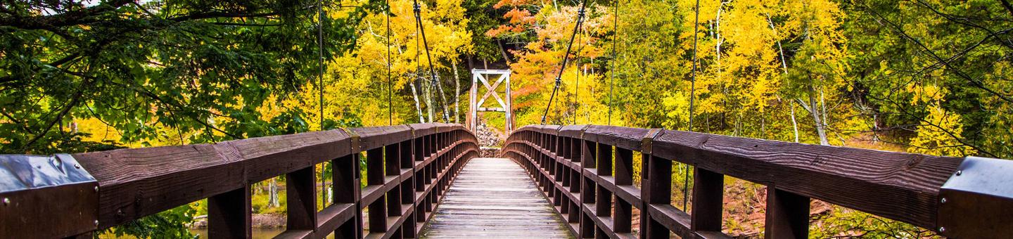
Visitors enjoy boating, fishing, hiking, swimming, and viewing waterfalls. The Black River Harbor Recreation Area has docking and fuel services for day and transient boaters, a boat launch, a large picnic area with a swing set, a campground with 39 campsites, beach access to Lake Superior, and five scenic waterfalls along the wild and scenic Black River. The day-use picnic area has a suspension bridge over the Black River with a hiking trail to a beautiful sand and pebble beach on Lake Superior. The campground is situated among hemlock and pine trees at an elevation of 840 feet, on a bluff overlooking Lake Superior and offers a scenic overlook of Lake Superior's Apostle Islands.The Ottawa National Forest encompasses nearly one million acres on the west side of Michigan's Upper Peninsula. The forest extends from the south shore of Lake Superior to the Wisconsin border. It is distinguished by rolling hills dotted with lakes, rivers and waterfalls.
Nearby Attractions
For a panoramic view of the area, visit Copper Peak International Ski Flying Hill, a 17-story steel ski jump. Visitors can take an elevator up to the top. The attraction is a short drive from the campground. The Porcupine Mountain Wilderness State Park in Michigan can be seen in the distance from the beach and is less than a one-hour drive from the Harbor.Charges & Cancellations
Cancellations
- If you cancel reservation at least 14 days prior to check in date, all recreation fees, minus a $10 cancellation fee and the reservation fee ($8 if made online or $9 if made through the call center) will be refunded.
- If you cancel reservation less than 14 days prior to check in date, you forfeit the entire total paid.
No Show
Staff will hold facility until check-in time on the arrival date.
For more information about rules and reservation policies, visit the Recreaiton.gov Rules and Reservations Policy page.
MARION LAKE GROUP SITE Campground
List of CampsitesOverview
The sparkling Marion Lake offers breathtaking and exciting camping for your next family trip. Live it up on the water with your jet skis or wake board, or tone down the pace with a full day of fishing. The Marion Lake Group Site is an ideal way to spend time with friends and family for all the water activities you can imagine. Marion Lake is in the Ottawa National Forest, a protected area in the Western Upper Peninsula of Michigan. It stretches from the Lake Superior shoreline to the Wisconsin border, and attracts deer and many types of migrating birds.Recreation
A swim beach is adjacent to the group site.Facilities
A convenient path leads to the lake and boat launch. Water is not available on-site, but is a short walk away.Natural Features
The campground is in a large, grassy field surrounded by hemlock and hardwood trees with an opening to Marion Lake. The altitude is 1,627 feet, with lightly rolling hills stretched between the many other lakes in the area.Nearby Attractions
Hiking enthusiasts will find scenic trails throughout the Sylvania Wilderness area, a region to the west with old-growth forests and 34 named lakes. On the way, stop by the Ottawa Visitor Center in Watersmeet for some interesting exhibits.SYLVANIA WILDERNESS BACKCOUNTRY CAMPING Campground
List of CampsitesOverview
Planning a trip to the Sylvania Wilderness? Watch for Alerts at the top of the page for any Alerts regarding this facility.
The Sylvania Wilderness encompasses 18,327 acres of primitive lands and is part of the National Wilderness Preservation System. Visitors can camp in 50 designated campsites within the Sylvania Wilderness. Visitors enjoy endless canoeing, fishing, hiking and wildlife viewing opportunities.
Recreation
Sylvania's abundant lakes provide plentiful non-motorized boating, canoeing, kayaking and fishing opportunities. Other popular activities include hiking and viewing wildlife.Facilities
Sylvania Wilderness Backcountry Camp is not a physical campground located at one location. The 50 individual sites are located along eight lakes within the Sylvania Wilderness. Camping is allowed only at designated sites. Campsites are primitive, but each is equipped with a campfire ring and a wilderness latrine.Natural Features
The old-growth forests and pristine lakes in the region provide habitat for a wide range of animal and plant life, including rare orchids, bald eagles, loons and osprey. The wilderness contains 34 named lakes, some with sandy beaches and others surrounded by record-size red and white pines. The Ottawa National Forest is comprised of nearly 1 million acres and is located in the western reaches of Michigan's Upper Peninsula. The forest's rolling, tree covered hills extend from the south shore of Lake Superior to the Wisconsin border. Lakes, rivers and waterfalls are found throughout this beautiful landscape.Charges & Cancellations
Cancellations
- If you cancel reservation at least 14 days prior to check in date, all recreation fees, minus a $10 cancellation fee and the reservation fee ($8 if made online or $9 if made through the call center) will be refunded.
- If you cancel reservation less than 14 days prior to check in date, all recreation fees, minus $10 cancellation fee, reservation fee ($8 if made online or $9 if made through the call center), and first night’s use fee will be refunded.
- The reservation fee ($8 if made online or $9 if made through the call center) is non-refundable.
No Show
Staff will hold a campsite until check-out time on the day following the arrival date.
For more information about rules and reservation policies, visit the Recreaiton.gov Rules and Reservations Policy page.
Iron River Ranger District Facility
Iron River is located in Iron County, in the western portion of Michigan's Upper Peninsula, just seven miles from the Wisconsin border. The border is shared with the Nicolet National forest. The Iron River Ranger District is 138,000 acres in size. Recreation opportunities include two camping for fee campgrounds and two rustic campgrounds. Three wilderness areas are located on adjacent districts. The area's climate is truly unique for each season of the year. The weather is summarized as follows: 31 inches of average annual precipitation, 68 inches of snowfall, an average of 62 frost-free days, 59 degree F. average temperature May through September, and long cold winters.
Four-season recreation is Iron County's claim to fame. 2,175 lakes and 902 miles of streams offer unlimited challenges for both warm and cold-water fishing. Three rivers on the district have recently been designated as recreational rivers under the Wild and Scenic rivers Act. Northern hardwoods, pine, balsam fir, and spruce cover 80% of the county. More whitetail deer Boone and Crockett entries have been taken from the forests of Iron County than any other Michigan county. Add to this, the title of woodcock capital of the world and one cannot find any better small and big game hunting anywhere in the Midwest.
When winter arrives, it's no time to rest. 212 miles of snowmobile trails connect to a vast system of trails throughout upper Michigan and northern Wisconsin. The Iron River District, in cooperation with Covenant Point Bible Camp, grooms and maintains a Nordic ski trail, and Ski Brule, a major ski resort, is just minutes from town.
Kenton Ranger District Facility
The Kenton Ranger District is the largest and oldest district on the Ottawa, dating back to 1931, when the forest had only one district. The recreation program includes a wide variety of dispersed activities including hunting, fishing, remote camping and hiking including two wildernesses, snowmobiling on numerous maintained trails, recreational driving with a variety of potential destinations including lakes, waterfalls and other scenic attractions. Developed recreation includes 7 campgrounds (3 on rivers, 4 on lakes), 2 waysides on M-28 and a CCC era organizational camp, which is used seasonally by a wide variety of organizations for outdoor education and other purposes.
The McCormick Wilderness and The Sturgeon Gorge Wilderness are located on the District.
The district is a premium spot for the outdoorsman. Whitetail deer are numerous. Black bear are common and getting more numerous. Upland game birds include ruffed grouse and woodcock. There is some local Canada geese and ducks in addition to migrants, which concentrate on local farm fields and Michigan DNR wildlife projects. Wild turkey hunting is also available with a two-hour drive. Fishing includes brook, rainbow and German brown trout, Chinook and Coho salmon, walleye, large and small mouth bass, northern pike, musky and numerous species of pan fish. The area is also home to a wide variety of other wildlife including moose, gray (timber) wolves, fisher, pine marten, bald eagles, osprey, loons, river otter, bobcat, mink, beaver and many more. Sightings of bald eagle are common occurrences with local population being among the highest in the Midwest along with numerous nesting sites. In general, it is a good place if you enjoy clean air, water, outdoor experiences and nature.
Sturgeon River Gorge Wilderness Facility
The Wild and Scenic Sturgeon River rushes out of the northern portion of this wilderness, over the 20 foot volcanic outcroppings of Sturgeon Falls, and through a gorge that reaches 350 feet in depth and a mile in width. Throughout this rugged, steep Wilderness, the Sturgeon and Little Silver Rivers and their tributaries have carved falls, rapids, ponds, oxbows, and terraces. Stunning views are possible from the eastern rim of the gorge. Except for a few naturally bare slopes, most of the land is forested with pine, hemlock, aspen, sugar maple, birch, and basswood. When the leaves of the hardwoods change color in the fall, they form a vivid tapestry. There are few established trails in Sturgeon River Gorge Wilderness, and the few overgrown logging roads are hard to find and follow. The North Country National Scenic Trail parallels the northern and eastern boundaries for about eight miles. Sturgeon River Campground offers seven sites on the southeastern boundary. In spring and during peak runoff, kayaking and white water canoeing are challenging, and only recommended for advanced paddlers.
Sturgeon River Gorge Wilderness Map
Ontonagon Ranger District Facility
Ontonagon Ranger District is on the shores of Lake Superior, largest of the Great Lakes, and the mouth of the Ontonagon River. There are numerous outdoor recreational opportunities. Hunting, fishing, swimming, hiking, boating, and ATV riding are available in the summer and fall months. In the winter downhill, cross-country skiing, snowmobiling and snowshoeing are available.
Bessemer Ranger District Facility
Bessemer Ranger District has a variety of traditional lands, fisheries, and timber programs with new challenges in wildlife partnerships, in recreation (Region 9's only Harbor) and with management of our Wild and Scenic Rivers, and Scenic Byway. The district has an excellent reputation for being team participants at both the district and Forest levels.
There is something for everyone with 32 waterfalls; 1200 miles of rivers and streams; over 1,100 lakes; and 30 miles of Lake Superior shoreline just 15 minutes north on County Road 513.
It's a perfect spot for fishing, picnicking, swimming, boating, canoeing, hiking, camping and hunting for grouse, black bear, and white tailed deer. BESSEMER'S Fourth of July celebration and Pumpkinfest are among the finest in the Midwest, and involves the whole community. A Lake Superior fishing derby on Labor Day ushers in the fall color and salmon run for the Black River Harbor area.
The Black River Harbor Recreational Area is a popular destination for many when visiting the Bessemer Ranger District. This recreational area provides a marina/harbor, campground, watersfalls, access to the North Country Trail.
BESSEMER is in the heart of Big Snow country where fresh powder graces four ski resorts with novice to expert trails atop three mountain ranges; kilometers of groomed cross-country trail; The almost one million acre Ottawa National Forest is located throughout the western half of the Upper Peninsula. The forest has five ranger districts and a nursery that serves the Great Lakes area. The Eastern Time zone cuts across the heart of the Forest.
Bobcat Lake Campground Campground
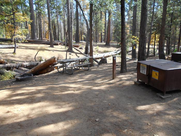
List of CampsitesLocated in Gogebic County just 3 miles southeast of Marenisco, Mi., on the Bessemer Ranger District in the southern half of the Ottawa National Forest. Bobcat Lake campground features one loop with 11 campsites. Campsites are bordered by vegetation providing privacy between sites. These drive in sites offer a tent pad, wood table, fire ring, lantern post and gravel parking spur. Two accessible vault toilets are located in the campground and water is provided by a centrally located hand pump in the loop. A sandy beach and day use area, complete with vault toilets, tables, grills and changing house is located 1/2 mile east of the campground. Also adjacent to the campground is a boat ramp which provides access to a variety of game fish.
Langford Lake Boat Launch Campground
List of CampsitesThis launch is located 11 miles to the southeast of Marenisco, Mi., on the Bessemer Ranger District.
Yondota Falls Facility
Yondota Falls, located just 3 1/2 miles north of Marenisco Mi., on the Bessemer Ranger District, is a series of falls, so be sure you walk far enough to see them all. The trail is not long, but does drop in elevation along the river, so the uphill return hike may make this a moderately difficult trail.
Kakabika Falls Facility
Kakabika Falls, located approximately 12 miles northeast of Marenisco Mi., on the Bessemer Ranger District. This falls is actually a series of "S" turns as the river drops in elevation. The trail is not a long trail and not too difficult. There is some good berry picking near here as well as great fishing.
Little Falls Facility
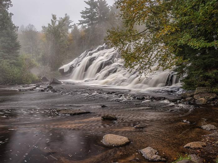
Located on the southern portion of Bond Falls Flowage in the Watersmeet Ranger District.
Sylvania (Clark Lake) Campground Campground
List of CampsitesOverview
Sylvania (Clark Lake) Campground is located seven miles southwest of Watersmeet, Michigan, adjacent to the 18,327 acre Sylvania Wilderness Area. This 48-site campground provides a home base for visitors who venture into the wilderness on day outings. Also a great camping area in general or overnight camping just 5 minutes off Highway U.S. 2. Some electrical sites available, pressurized toilet facilities and an RV Dump and Water Station. Some sites are reservable but there are always sites available on a first come first serve basis as well!
Recreation
Sylvania's abundant lakes provide plentiful non-motorized boating, canoeing, kayaking and fishing opportunities. Other popular activities include hiking and viewing wildlife.Facilities
This campground consists of four camping loops with a total of 48 campsites and provides drive-in campsites that can accommodate tents, trailers and motor homes. All sites are spaced with natural vegetation for screening. Each campsite offers a wood table, fire ring, lantern post and parking spur. Drinking water is provided by faucets in loops 2, 3, and 4, while two flush toilet facilities and one accessible vault toilet are evenly spaced throughout the campground. Also located adjacent to the campground is a day use facility that has showers, a picnic area, canoe access landings, trailheads and a swimming beach. Located adjacent to the campground is a water and sewage dump station for RV's at a $5.00 charge. Some sites are reservable on Recreation.gov but other sites are on a first come, first serve basis and typically there is always a site available.
Natural Features
The old-growth forests and pristine lakes in the region provide habitat for a wide range of animal and plant life, including rare orchids, bald eagles, loons and osprey. The wilderness contains 34 named lakes, some with sandy beaches and others surrounded by record-size red and white pines.The Ottawa National Forest is comprised of nearly one million acres and is located in the western reaches of Michigan's Upper Peninsula. The forest's rolling, forest covered hills extend from the south shore of Lake Superior to the Wisconsin border. Lakes, rivers and waterfalls are found throughout this beautiful landscape.
Nearby Attractions
Bond Falls located about 20 minutes North East. Porcupine Mountains located about 1 hour North West. Pictured Rocks National Lakeshore located about 2 hours North East. Keweenaw Peninsula is located about 1.5 hours North.BLACK RIVER HARBOR CAMPGROUND Campground
List of CampsitesOverview
Planning a trip to the Black River Harbor Campground? Watch for Alerts at the top of the page for any Alerts regarding this facility.
Black River Campground is adjacent to the Black River Harbor Recreation Area. The recreation area includes a pavilion, harbor and a large picnic area. The area provides for many opportunities for fishing, boating, backpacking, hiking, bird watching, photography and beautiful scenery for relaxation in the outdoors.
Recreation
The campground is adjacent to the Black River Harbor Recreation Area. The Harbor offers one of the area's few access points to Lake Superior, with boating and fishing being a major summer time activity. Fishing charters are available at the harbor dock area. The boat ramp can accommodate almost any craft trailered in. Parking for trucks and boat trailers is ample. The area has many trails that follow the Black River leading you to the many waterfalls along the river. The recreation area has a large grassy area for picnics.
Facilities
The Black River Campground has 38 available campsites that can accommodate RVs, campers or tents. There are two concrete vault toilet buildings at either end of the campground. There are 10 pressurized water spigots spaced throughout the camping areas for easy water access. All campsites are wooded with partial shade and have a generous area to spread out in. There are five campsites that are within a few hundred feet of Lake Superior.Natural Features
Known for its spectacular waterfalls, idyllic beaches, scenic hiking trails and tranquil campground, the Black River Harbor Recreation Area is a popular destination throughout the year. Originating in Wisconsin, the Black River flows through forested areas of large pine, hemlock and hardwood trees. The River has a series of scenic waterfalls as it drops in elevation to meet Lake Superior. Tannin (tannic acids) from hemlock trees is what gives it its unique color.Nearby Attractions
A historic pavilion built by the Civilian Conservation Corps is located in the recreation area next to the campground. The recreation area includes a large picnic area and Black River Harbor that has fishing charters available and in itself is a scenic area to explore. Trails run adjacent to the Black River and lead to several waterfalls. A foot bridge and short walk will take you across the Black River to Lake Superior and the sand beach swimming areas.Charges & Cancellations
Cancellations
- If you cancel reservation at least 2 days prior to check in date, all recreation fees, minus a $10 cancellation fee and the reservation fee ($8 if made online or $9 if made through the call center) will be refunded.
- If you cancel reservation the day before or the day of check in date, all recreation fees, minus $10 cancellation fee, the reservation fee ($8 if made online or $9 if made through the call center), and the first night’s use fee will be refunded. Cancellations for one night reservations will forfeit the entire amount paid.
- The reservation fee ($8 if made online or $9 if made through the call center) is non-refundable.
No Show
Staff will hold a campsite until check-out time on the day following the arrival date.
For more information about rules and reservation policies, visit the Recreaiton.gov Rules and Reservations Policy page.
CLARK LAKE PAVILION Campground
List of CampsitesOverview
The Clark Lake Pavilion, located within the Clark Lake day use area, sits in a beautiful north woods setting; at the north end of Clark Lake. The pavilion provides a large indoor gathering area complete with picnic tables, limited seating and a fireplace. The large parking area serves as parking for the pavilion and Clark Lake day use area; there are 46 parking spots, 2 accessible parking spots, and 1 bus/larger vehicle parking spot.
Recreation
Clark Lake day use area, Clark Lake campground, and the Sylvania Wilderness provide visitors with a multitude of opportunities to enjoy picnicking, paddling, fishing, hiking, swimming, camping and the solitude of wilderness. With more than 30 named lakes, 26 miles of hiking trails, and 50 backcountry campsites on the wilderness landscape there are no shortage of hiking, paddling, and camping opportunities throughout the area. The Clark Lake campground is just a short drive from the pavilion and provides an overnight camping option for those wishing to camp in the area.Facilities
The Clark Lake day use area offers a large outdoor picnic area complete with picnic tables and grills, a beautiful sandy beach, as well as an enclosed pavilion with a fireplace. Co-located within the pavilion are flush toilets and shower facilities. Nearby, the Clark Lake campground offers four camping loops with a total of 48 campsites, paved access roads, pressurized water system, flush toilets and a trailer dump station. There are canoe access landings at the north end of Crooked Lake and Clark Lake to access paddling opportunities within the wilderness.Natural Features
The Clark Lake pavilion sits just outside the Sylvania Wilderness boundary at the north end of Clark Lake. Clark Lake is a crystal clear lake with a natural sandy shoreline, providing excellent swimming and outdoor picnic opportunities just a short walk from the pavilion.Sylvania Wilderness encompasses 18,327 acres of primitive lands and is part of the National Wilderness Preservation System. With its untouched, virgin timber still standing tall, Sylvania looks and feels today like it did when it was first discovered. Sylvania Wilderness welcomes the new and returning visitor with towering, ancient trees, the lonesome call of loons and soft pine needles underfoot. A staggering 4,000 acres of this wilderness is covered by water.
Nearby Attractions
The Wilderness Lakes Trails system encompasses 38 miles of bike and pedestrian trails that traverse Michigan and Wisconsin, as well as encircling Sylvania Wilderness. This trail system provides a multitude of riding and pedestrian opportunities and has something for everyone. The Land O' Lakes cross country ski trails, adjacent to Sylvania Wilderness, offer approximately 6.5 miles of groomed ski trail. Whether you are an expert skier, or a beginner, you're sure to find a favorite trail that lets you enjoy the great outdoors all winter long. The almost one million acres of the Ottawa National Forest are located in the Western Upper Peninsula of Michigan. The forest extends from the south shore of Lake Superior to the Wisconsin border. The area is rich in wildlife viewing opportunities; breathtaking views of rolling hills dotted with lakes, rivers and waterfalls; and spectacular fall colors.Charges & Cancellations
Cancellations
- If you cancel reservation at least 14 days prior to check in date, all recreation fees, minus a $10 cancellation fee and the reservation fee ($8 if made online or $9 if made through the call center) will be refunded.
- If you cancel reservation less than 14 days prior to check in date, you forfeit the entire total paid.
No Show
Staff will hold facility until check-in time on the arrival date.
For more information about rules and reservation policies, visit the Recreaiton.gov Rules and Reservations Policy page.
LAKE OTTAWA PAVILION Campground
List of CampsitesOverview
Planning a trip to the Lake Ottawa Pavilion? Watch for Alerts at the top of the page for any Alerts regarding this facility.
The Lake Ottawa Pavilion, located within the Lake Ottawa Recreation Area, sits in a beautiful north woods setting; along the shore of Lake Ottawa. The Civilian Conservation Corps-era pavilion provides a large indoor gathering area complete with picnic tables, limited seating and a fireplace.
Recreation
Lake Ottawa is a clear lake with a natural sandy bottom, providing excellent swimming opportunities. Just a short walk from the pavilion is the Lake Ottawa campground and trailhead for the Ge Che hiking trail. The Ge Che trail provides approximately nine miles of hiking opportunities; winding through the campground, day use area and surrounding northern hardwood forest. Spend the night in the Lake Ottawa campground. Choose from campsites located along the lakeshore or those nestled in a forest setting. The boat landing has ample parking and provides anglers with access to this fishery. Anglers enjoy fishing for trout, bass, walleye, and pan-fish.Facilities
The Lake Ottawa pavilion offers an enclosed pavilion with a fireplace. Surrounding the pavilion is a very large picnic area complete with water bubblers, picnic tables and grills. The area also has a swimming beach and athletic field for family fun. Co-located within the pavilion are flush toilets and change rooms.Natural Features
Lake Ottawa is almost completely surrounded by National Forest System land, providing a lovely view of the shoreline and forest.
Nearby Attractions
Lake Ottawa campground offers 32 campsites, paved access roads, pressurized water system, flush toilets, a trailer dump station, and a picnic shelter with two stone fireplaces and original log picnic tables which were constructed by the Civilian Conservation Corps in the late 1930s. Each campsite has natural vegetation providing some privacy from neighboring sites. Located in the general area is Lake Ottawa, Brule Lake, Hagerman Lake, Brule River, Bass Lake, and miles of hiking trails. Lake Ottawa is a deep cold water lake that provides fishermen with a good variety of game fish. There is a boat landing with ample parking to access Lake Ottawa. The Ge Che hiking and ski trail and the Historic Mile Post Zero/Treaty Tree trail provide hiking opportunities through northern hardwood forests. The almost one million acres of the Ottawa National Forest are located in the Western Upper Peninsula of Michigan. The forest extends from the south shore of Lake Superior to the Wisconsin border. The area is rich in wildlife viewing opportunities; breathtaking views of rolling hills dotted with lakes, rivers and waterfalls; and spectacular fall colors.Charges & Cancellations
Cancellations
- If you cancel reservation at least 14 days prior to check in date, all recreation fees, minus a $10 cancellation fee and the reservation fee ($8 if made online or $9 if made through the call center) will be refunded.
- If you cancel reservation less than 14 days prior to check in date, you forfeit the entire total paid.
No Show
Staff will hold facility until check-in time on the arrival date.
For more information about rules and reservation policies, visit the Recreaiton.gov Rules and Reservations Policy page.
