
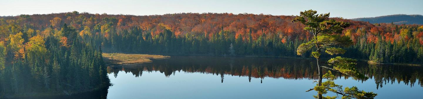
Superior National Forest

 |
 |
 |
 |
2,000 miles of trails designed for hiking, hunting, riding and more. Camp on one of the many developed "fee", rustic, or backcountry campsites, most of which are on a body of water. Boat, fish, swim or picnic at one of lake accesses, fishing piers, swimming beaches, or picnic areas. Drive on one of three national scenic byways. Explore the Boundary Waters Canoe Area Wilderness, with over 800,000 acres it is the largest designated wilderness in the eastern.


RecAreaDirections
Open with Google Map
Misc
| Stay Limit | |
| Reservable | false |
| Keywords | |
| Map Link | |
| Contact Phone | |
| Contact Email |
Permits info
Facilities
ECHO LAKE (MINN) Campground
List of CampsitesOverview
Echo Lake is located on the west end of the Echo Trail, a remote country road that traverses through the heart of the Western Superior National Forest. This quiet campground, where the sounds of birds and the wind are often heard, is a peaceful alternative to the hustle and bustle of the area's resort scene. A variety of campsites, activities and amenities offer a comfortable stay for RV, trailer and tent campers. Superior National Forest, located in northeastern Minnesota's arrowhead region, is comprised of three million acres. The forest spans 150 miles along the United States-Canada border. Visitors can find recreation opportunities year-round, including travel in the famous Boundary Waters Canoe Area Wilderness.Recreation
Echo Lake is a popular fishing spot for walleye, northern pike, panfish, black crappie, white sucker and yellow perch also living in the lake. The surrounding national forest offers a wide variety of recreational opportunities, including hiking in secluded woodlands and canoeing in pristine lakes and rivers. View recreation guides and maps of hiking trails and canoe routes in the national forest.Facilities
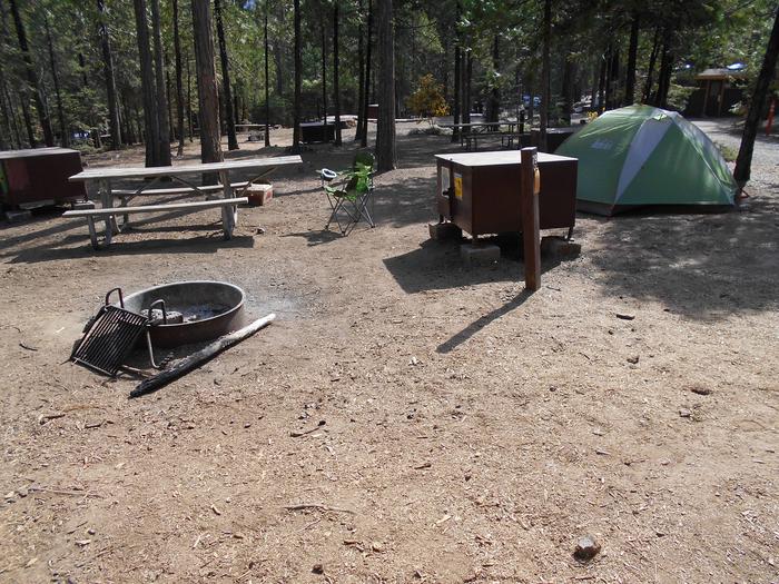
The campground provides 22 sites, with 13 reservable sites (1 group site and 12 standard sites) and 9 first come-first served. The sites are non- electric and amenities include vault toilets, solar powered water, tables, garbage service, campfire rings.
A group campsite is available for groups of up to 21 people. Three free First Come First Serve dispersed campsites that can be accessed only by boat are located around the lake as well.
Heavy vegetation may limit the lake view from some sites; however, there are numerous trails leading to the water. Young trees and lush ground plants provide privacy between sites.
A boat ramp and sandy beach are provided for access to water activities and swimming.
Natural Features
This campground is on the south shore of the 1,222-acre Echo Lake and is surrounded by a mix of aspen, balsam, spruce, maple and pine trees, which provide ample shade.Nearby Attractions
Possible day trips from the campground include Voyageurs National Park, Crane Lake, Vermillion Falls, Echo Lake Trail (1.5 miles) and Echo Lake Hunters Walking Trail (10 miles).Numerous outdoor recreation opportunities lie within Superior National Forest's 77 lake accesses, 13 fishing piers, 10 swimming beaches and 22 picnic areas. The forest is also home to three scenic byways and the Boundary Waters Canoe Area Wilderness.
Additional sites of interest
JEANETTE LAKE Campground
List of CampsitesOverview
Jeanette Lake Campground is a small, single-loop campground on a peninsula reaching out onto the glacier-carved Lake Jeanette in Superior National Forest. Originally built by the Civilian Conservation Corps in the 1930s, this sweet, picturesque campground is well worth the drive.The facility provides sites that are usually accessible to RVs and tent trailers along with tent-only and hike-in sites.
Superior National Forest, located in northeastern Minnesota's arrowhead region, is comprised of three million acres. The forest spans 150 miles along the United States-Canada border. Visitors can find recreation opportunities year-round, including travel in the famous Boundary Waters Canoe Area Wilderness.
Recreation
The winding shoreline and islands make the 638-acre Lake Jeanette a great place to explore in a canoe or kayak. Fishing opportunities include walleye, northern pike and perch. The campground provides access to the Astrid Lake Hiking Trail for those who want to stretch their legs.The surrounding national forest offers a wide variety of recreational opportunities, including hiking in secluded woodlands and canoeing in pristine lakes and rivers.
View recreation guides and maps of hiking trails and canoe routes in the national forest.
Facilities
There are 12 sites total with six reservable standard sites, 4 First Come First Serve standard sites, and two First Come First Serve tent-only sites.
Most sites have a view of the lake and some are located on the lakeshore. The campsites are close together providing fair privacy, except for walk-in sites which enjoy excellent privacy.
The walk-in tent sites have an additional backcountry latrine nearby (campers may want to bring toilet paper).
Lake Jeanette also has six dispersed backcountry sites that are first-come, first-served and accessible only by boat.
Natural Features
Lake Jeanette is not the largest or most isolated lake in the national forest, but it feels like it is both. Created long ago by a massive glacier, this lake is considered by many to be a special location.The campground is wooded with a pleasant mix of hardwoods, pine and spruce providing shade for most sites. The understory of fern, wildflowers and grass is kept under control by mowing, giving the campground a manicured appearance.
Glacial "erratics" (massive boulders) left behind by the receding glacier give the campground character and a place for moss to grow.
Nearby Attractions
Possible day trips from the campground include Voyageurs National Park, Crane Lake and Vermillion Falls.Numerous outdoor recreation opportunities lie within Superior National Forest's 77 lake accesses, 13 fishing piers, 10 swimming beaches and 22 picnic areas. The forest is also home to three scenic byways and the Boundary Waters Canoe Area Wilderness.
Additional sites of interest
PFEIFFER LAKE Campground
List of CampsitesOverview
Pfeiffer Lake Campground, located adjacent to it's namesake lake, is a small, peaceful and scenic facility in the Superior National Forest of Minnesota. The lake's healthy population of fish make it a favorite spot for anglers, and the swim beach, playground and picnic area provide fun for the whole family.Superior National Forest, located in northeastern Minnesota's arrowhead region, is comprised of 3 million acres. The forest spans 150 miles along the United States-Canada border. Visitors can find recreation opportunities year-round, including travel in the famous Boundary Waters Canoe Area Wilderness.
Recreation
Pfeiffer Lake has many activities, fishing being one of the most popular. Panfish, bass, perch and walleye can be caught from the fishing dock or offshore, accessible via the facility's boat ramp.
Canoeing and kayaking are also a favorite pastime.
The picnic area is next to a grassy swimming beach and 3-mile hiking trail.
Facilities
The campground has 16 total campsites 8 reservable and 8 first-come, first-served campsites, some of which can accommodate RVs. The campground provides fire rings, tables, drinking water, vault toilets and a centrally located playground that offers children a great place to run off the day's energy.
A campground host is on site to answer questions.
Natural Features
The campground sits in a forest of mixed hardwoods and pine and new pine and cedar have been planted.
The lake is 57 acres and has an irregular shoreline great for exploring by canoe or kayak. The lake area is also a nesting place for loons and a habitat for other birds and wildlife.
Nearby Attractions
Numerous outdoor recreation opportunities lie within Superior National Forest's 77 lake accesses, 13 fishing piers, 10 swimming beaches and 22 picnic areas. The forest is also home to three scenic byways.
Additional sites of interest
WHITEFACE RESERVOIR Campground
List of CampsitesOverview
Whiteface Reservoir Campground offers an ideal getaway for anglers, boaters and families. The provided swim beach, playground and five picnic areas offer hours of entertainment, and the scenery provides a relaxing backdrop for the day's activities.
Superior National Forest, located in northeastern Minnesota's arrowhead region, is comprised of 3 million acres. The forest spans 150 miles along the United States-Canada border. Visitors can find recreation opportunities year-round, including travel in the famous Boundary Waters Canoe Area Wilderness.
Recreation
A boat launch located at the campground provides access to the great walleye, panfish and northern fishery in the reservoir. The fish cleaning house next to the boat launch gives anglers the chance to clean their fish in time for lunch at the picnic area.Children will have a great time playing on the playground and on the small, sandy beach. There are also 2.5 miles of hiking trails within the facility.
Facilities
Whiteface Reservoir Campground provides sites for RV and tent camping, along with a few hike-in sites. The opposite shoreline is dotted with private residences.A few sites overlook the reservoir, and all sites offer shade and privacy. The campground also has some long-term sites that have a yearly fee associated with them.
Campground hosts are available on-site to assist visitors.
Natural Features
Campsites are in a mixed forest including aspen, birch and maple. The reservoir provides 4,980 acres of calm, clean waters. Numerous species of birds and wildlife inhabit the area.Nearby Attractions
There is a store available on-site that provides firewood, bait, bug spray, snacks and other small items.Numerous outdoor recreation opportunities lie within Superior National Forest's 77 lake accesses, 13 fishing piers, 10 swimming beaches and 22 picnic areas. The forest is also home to three scenic byways.
Additional sites of interest.
contact_info
For facility specific information, please call (218) 453-8650.CADOTTE LAKE Campground
List of CampsitesOverview
Cadotte Lake Campground lines the western shore of Cadotte Lake in Superior National Forest. A boat ramp and fishing dock make the campground convenient for anglers, and the sandy swimming beach is popular among families.Superior National Forest, located in northeastern Minnesota's arrowhead region, is comprised of 3 million acres. The forest spans 150 miles along the United States-Canada border. Visitors can find recreation opportunities year-round, including exploring the famous Boundary Waters Canoe Area Wilderness.
Recreation
The 318-acre Cadotte Lake is a great spot to fish for walleye and northern pike. The surrounding national forest offers a wide variety of recreational opportunities, including hiking in secluded woodlands and canoeing in pristine lakes and rivers.View recreation guides and maps of hiking trails and canoe routes in the national forest.
Facilities
Cadotte Campground is in a wooded area with private sites, some of which have views of the lake and access to trails that lead to the water. Some campsites can accommodate RVs up to 45 ft. in length.
The facility provides fishing areas, a boat ramp, dock and sandy beach.
Natural Features
Superior National Forest is known for its boreal forest ecosystem, numerous clean lakes and diversity of animals and plants. The campground lies in a mixed evergreen, birch and aspen forest.Nearby Attractions
Numerous outdoor recreation opportunities lie within Superior National Forest's 77 lake access points, 13 fishing piers, 10 swimming beaches and 22 picnic areas. The forest is also home to three scenic byways.FALL LAKE Campground
List of CampsitesOverview
Fall Lake Campground is located on the shores of Fall Lake and provides direct access into the Boundary Waters Canoe Area Wilderness (BWCAW). The campground opens in early May in time for walleye fishing season, making it a popular place for anglers. Others are drawn to Fall Lake for its birding, swimming, hiking and boating opportunities.Superior National Forest, located in northeastern Minnesota's arrowhead region, is comprised of 3 million acres. The forest spans 150 miles along the United States-Canada border.
Recreation
Part of Fall Lake lies within the BWCAW, while the rest of the lake is open to unrestricted boating, permits are required to enter the BWCAW. View recreation guides and maps of hiking trails and canoe routes in the national forest.Kids love the campground's swimming beach, playground and picnic area. A 1.5 mile hiking trail is also a favorite pastime for families. Anglers can try their luck for smallmouth bass, walleye, northern pike, crappie, perch and bluegill.
Some campers might be interested in the unique opportunity to view the visitor center's display of replica artifacts found during archaeological digs within the campground and surrounding areas.
There's no shortage of popular local events to attend, including the City of Ely's July 4th fireworks, the Blueberry Festival (the last full weekend in July) and the Harvest Moon Festival-mid September.
Facilities
This lake has some sites that can be reserved and some that are first-come, first-served. Many sites at Fall Lake are made to accommodate RVs including pull-through sites. Trees provide privacy between most campsites. The facility is very accessible.A store, canoe rentals, firewood and ice are available at the facility, and a campground host is on-site during the season.
Natural Features
The campground is nestled among majestic pine and abundant aspen and fir trees, providing the ultimate northwoods setting. Average summer temperatures are a pleasant 60-75 degrees. Birds and wildlife are abundant.Nearby Attractions
Guests may want to take a day trip to the Dorothy Molter Museum, International Wolf Center, North American Bear Center, Ely-Winton History Museum or Soudan Mine.By far the most popular nearby attraction is the Boundary Waters Canoe Area Wilderness. Over one million acres in size, the Boundary Waters contain over 1,200 miles of canoe routes, 12 hiking trails and over 2,000 designated campsites.
IRON LAKE Campground
List of CampsitesOverview
Iron Lake Campground is located in a dense forest along the banks of Iron Lake in far northern Minnesota. The campground is unique due to its remoteness and small size. Fishing and canoeing are its biggest draws, as the lake provides access to the Boundary Waters Canoe Area Wilderness.The Ham Lake Fire passed through the campground in 2007. Visitors may be surprised at how the burned area is greening up. Soils and seedling trees are delicate. Some dead trees, which were left standing to provide habitat, may be hazardous. Use caution and stay out of closed areas.
Recreation
Iron Lake provides many boating opportunities. The campground offers plenty of canoeing and fishing opportunities. Walleye and northern pike fishing are usually good. Canoes, kayaks and small boats must be carried down to access the lake.When portaging or paddling out of this lake and into another, visitors should find out if they will be entering the Boundary Waters Canoe Area Wilderness. Entry requires a permit (self-issued for day use) and visitors must follow wilderness regulations including group size.
**View recreation guides and maps of hiking trails and canoe routes in the national forest.
View recreation guides and maps of hiking trails and canoe routes in the national forest.
Facilities
This campground is small and simple. Sites are organized into one loop near the water. There are no electric hookups. Site 6 is a first-come, first-served site.Vault toilets, drinking water and trash bins are provided. Conveniences are available at area lodges and resorts. A campground host from another facility visits here every other day, and the facility is routinely patrolled by the County Sheriff and the concessionaire.
Natural Features
Iron Lake is in a burn area, and visitors can see post-fire ecology including uncommon black-backed woodpeckers. Moose, bear, loons and other wildlife live in the area. Blueberries grow abundantly in the area and can be picked in mid to late summer.Nearby Attractions
The BWCAW is by far the most popular nearby attraction. Over 1 million acres in size, the Boundary Waters extend nearly 150 miles along the United States-Canada border and contains over 1,200 miles of canoe routes, 12 hiking trails and over 2,000 designated campsites.Boundary Waters Canoe Area Wilderness
Additional sites of interest
TRAILS END CAMPGROUND Campground
List of CampsitesOverview
Trail's End Campground is located next to the Boundary Waters Canoe Area Wilderness (BWCAW) in a remote area of Superior National Forest in northern Minnesota. It is a wonderful place to sit and enjoy life, or get out on the water to canoe and fish. Berry picking and wildlife viewing are also great fun.Recreation
Trail's End includes four entry points (54, 55, J and K) into the BWCAW, offering plenty of boating, canoeing and fishing opportunities. Overnight, day use and boat motor permits are required for entry, and horsepower limits are in effect. Day use and overnight permits are available at the campground.Wildlife viewing is exceptional for bald eagles, osprey, loons and moose, and fishing is good for walleye, northern pike, smallmouth bass and lake trout.
View recreation guides and maps of hiking trails and canoe routes in the national forest.
Facilities
Many campsites are walk-to sites designated for tent camping only. Some have a view of or access to water, while other have steep drop-offs. Other campsites can accommodate equipment ranging in size from tents to 45-foot RVs. The campground is routinely patrolled by the County Sheriff and campground host.Commercial services include canoe rentals, outfitting, showers, groceries and gear. Long and short term parking for the BWCAW is also available.
Natural Features
Trail's End sits along the Seagull River and provides access to Seagull, Gull and Saganaga Lakes. Numerous species of wildlife live in and around the campground, and blueberries grow abundantly on the forest floor.White and red pine, aspen and birch trees grow in the forested parts of the facility, providing shade. The fire burned a mosaic pattern, reducing some areas to ash while leaving others untouched. Many trees survived and burned areas have begun to grow again.
This is a great opportunity to see a young forest rejuvenate after a fire. Post-fire soils and young trees are delicate, so caution should be taken while walking in the forest.
Nearby Attractions
The nearby Chik-Wauk Museum and Nature Center is a great way to spend an afternoon with the family. Many nature trails crisscross the center's 50-acre grounds.The BWCAW is by far the most popular nearby attraction. Over 1 million acres in size, the Boundary Waters extend nearly 150 miles along the United States-Canada border and contain over 1,200 miles of canoe routes, 12 hiking trails and over 2,000 designated campsites.
Boundary Waters Canoe Area Wilderness
Additional sites of interest
FLOUR LAKE CAMPGROUND Campground
List of CampsitesOverview
Flour Lake Campground provides a convenient home base for exploring the Boundary Waters Canoe Area Wilderness (BWCAW). Its scenery, amenities and access to outdoor recreation areas make it a popular campground for canoeing, kayaking, boating, and fishing.
Superior National Forest, located in northeastern Minnesota's Arrowhead Region, is comprised of 3 million acres. The forest spans 150 miles along the United States-Canada border. Visitors can find recreation opportunities year-round, including travel in the famed Boundary Waters.
Recreation
The eastern edge of Flour Lake has two separate portages for entering the BWCAW, thus this campground attracts canoe and kayak enthusiasts. Portages link Flour Lake with East Bearskin Lake and Moon Lake. Flour Lake also provides great fishing for bass, walleye and lake trout.Entering the BWCAW requires a permit. Day use permits are available at no charge; inquire at the campground host site. View recreation guides and maps of hiking trails and canoe routes in the national forest.
The half-mile Honeymoon Bluff Trail begins a short walk up the road from the campground and offers a great vista of Hungry Jack Lake. Many additional hiking, mountain biking and cross-country ski trails are nearby.
Facilities
Flour Lake Campground has private sites, each containing a picnic table and campfire ring with grill, and several have views of the lake. Some are reservable, while others are first-come, first-served. Large RVs are easily accommodated.The campground has accessible vault toilets, a solar-powered drinking water system, trash and recycling facilities and a public boat ramp. A fee dump station is nearby.
Natural Features
The campground sits on the quiet shore of 352-acre Flour Lake in a stand of mixed hardwoods and pine. The lake features several shallow bays that are frequented by a variety of wildlife, including moose, beavers, bald eagles, ducks, loons, songbirds and bears.Nearby Attractions
Golden Eagle Lodge, the lake concessionaire, offers many other services and conveniences as well as watercraft rental, coin-operated showers and approved firewood.By far, the most popular nearby attraction is the BWCAW, with over 1,200 miles of canoe routes, 12 hiking trails and over 2,000 designated campsites.
Boundary Waters Canoe Area Wilderness
Additional sites of interest
CRESCENT LAKE (MN) Campground
List of CampsitesOverview
Crescent Lake is an undeveloped lake surrounded entirely by the remote Superior National Forest. This quiet campground has waterfront campsites with easy access to fishing, exploring the nearby wilderness and simply enjoying the beauty of the natural area.Superior National Forest, located in northeastern Minnesota's arrowhead region, is comprised of 3 million acres. The forest spans 150 miles along the United States-Canada border.
Visitors can find recreation opportunities year-round, including travel in the famous Boundary Waters Canoe Area Wilderness.
Recreation
The fishing is good for walleye, northern pike and muskie. Crescent Lake allows motorized boat use without limit on horsepower, but is most appropriate for small fishing or similar type boats.The surrounding national forest offers a wide variety of recreational opportunities, including hiking in secluded woodlands and canoeing in pristine lakes and rivers.
View recreation guides and maps of hiking trails and canoe routes in the national forest.
Facilities
The campground has 32 sites situated on a peninsula that juts out into the lake, providing many sites with nice views of the water and some sites with access to the water.A few sites are first-come, first-served, including one primitive backcountry camping site that campers can boat into; access is a boat ramp on the northwest side of the lake.
Picnic tables, campfire grates, water pumps and vault toilets are provided. A fishing pier is located within the campground.
Natural Features
Superior National Forest is known for its boreal forest ecosystem, numerous clean lakes and diversity of plants and animals. The entire campground is heavily wooded with white pines, red pines, spruce, balsam, birch and aspen. Birds and wildlife are abundant, from moose and bear to bald eagles and loons.Nearby Attractions
The concessionaire Sawbill Canoe Outfitters maintains a store with showers, laundry, fishing licenses, fishing bait and tackle, ice, grocery and convenience items, canoe and camping gear rental and a pay telephone. It is 13 miles from the campground.Numerous outdoor recreation opportunities lie within Superior National Forest, including the nearby Boundary Waters Canoe Area Wilderness. Over one million acres in size, the Boundary Waters extend nearly 150 miles along the United States-Canada border and contain over 1,200 miles of canoe routes, 12 hiking trails and over 2,000 designated campsites.
Additional sites of interest.
Sawbill Lake Campground - Superior National Forest Campground
List of CampsitesOverview
Sawbill Lake Campground has immediate access to the Boundary Waters Canoe Area Wilderness, a beautiful, peaceful and wild natural feature of Minnesota's Superior National Forest. The campground acts as a convenient base camp for exploring the nearby wilderness.Superior National Forest, located in northeastern Minnesota's Arrowhead Region, is comprised of 3 million acres. The forest spans 150 miles along the United States-Canada border. Visitors can find recreation opportunities year-round, including travel in the famed Boundary Waters.
Recreation
This facility draws canoe enthusiasts who seek a quiet and convenient area from which to access the surrounding wilderness. Day and overnight use of the Boundary Waters requires a permit.The campground concessionaire, Sawbill Canoe Outfitters, provides a one-stop shop for canoeists of all levels within walking distance of the campground. Canoe rentals, permits and guided canoe trips are available.
Campers who wish to spend time relaxing at the campground can fish for northern pike and bass; hike, bike, picnic and attend educational programs.
View recreation guides and maps of hiking trails and canoe routes in the national forest.
Facilities
Sawbill Lake is comprised of two loops with a total of 51 campsites, 27 of which can be reserved (others are first-come, first-served). Campsites can easily accommodate large motorhomes and RVs. Some of the sites offer a partial lake view through the forest.The campground is equipped with picnic tables and campfire rings with grills, as well as vault toilets, a dump station, drinking water and trash and recycling bins.
Natural Features
Sawbill Lake is nestled in a thick pine forest that gives campsites excellent privacy. Birds and wildlife are abundant, from moose and bear to bald eagles and loons. Wildflowers add bright colors to the landscape in warmer months.The campground sits on a hill above Sawbill Lake. The 765-acre lake is within the Boundary Waters.
Nearby Attractions
Sawbill Canoe Outfitters maintains a store with showers, laundry, fishing licenses, bait and tackle, ice, grocery and convenience items, canoe and camping gear, rentals and a pay telephone.Over 1 million acres in size, the Boundary Waters Canoe Area Wilderness contains over 1,200 miles of canoe routes, 12 hiking trails and over 2,000 designated campsites.
Boundary Waters Canoe Area Wilderness
Additional sites of interest
EAST BEARSKIN LAKE CAMPGROUND Campground
List of CampsitesOverview
East Bearskin Lake Campground is located on its namesake lake, at the edge of the Boundary Waters Canoe Area Wilderness in Northern Minnesota. It is a perfect spot for visitors who want the experience found in Boundary Waters and the convenience of car camping. Visitors can reserve standard or walk-in tent sites, or rent small cabins that accommodate up to five or seven people. Canoeing, kayaking and motorized boating is available on East Bearskin Lake. The facility can be conveniently accessed by vehicle. Guests are responsible for their own travel arrangements and safety, and must bring several of their own amenities.Recreation
Over a million acres in size, the Boundary Waters Canoe Area Wilderness extends nearly 150 miles along the borders of the United States and Canada, containing over 1,200 miles of canoe routes, 12 hiking trails and over 2,000 designated campsites.The two eastern bays of the lake are within the boundaries of Boundary Waters, thus the campground attracts canoe enthusiasts. Portages link to Flour Lake. Entering the wilderness area requires a special permit. Day permits for non-motorized use are available at the campground, but overnight and motor use permits must be obtained in advance. More information on the Boundary Waters region can be found here.
East Bearskin Lake features several shallow bays, making the campground and shoreline good places for wildlife watching. Moose, beavers, eagles, ducks, loons, songbirds and bears are the most common visitors. See recreation guides and maps of hiking trails and canoe routes in the national forest.
Fishing is also a huge draw for the area, with East Bearskin Lake offering great fishing for bass, walleye and lake trout. A boat ramp at the campground allows motorboats and canoes access to the lake. Back on shore, a variety of hiking, mountain biking and cross-country ski trails are nearby.
Facilities
Campsites are arranged along one large loop and three smaller loops within the campground. A few sites provide a limited view of the water and all sites are within walking distance of the lake. Each campsite has an accessible fire ring with grill grates and a picnic table. Vault toilets and a solar-powered drinking water system are provided throughout the campground.The four rental cabins sleep five or seven people, respectively. Each has a single bed, double bed and set of bunk beds, while one has an additional bed. The cabins have no running water, electricity, heating or cooking facilities. Cabin visitors must use the campground's toilet and water facilities.
Cabin campers must bring their own sleeping pads, sleeping bags, cooking gear and food. Flashlights are also recommended.
Natural Features
The campground and surrounding area is shaded with majestic red and white pines, balsam fir, spruce, birch and aspen trees. A thick understory offers plenty of shade and excellent privacy between campsites. The campground lies on the shore of the 643-acre East Bearskin Lake, a typical loon nesting site.The surrounding Superior National Forest is located in northeastern Minnesota's arrowhead region and is comprised of 3 million acres. The forest spans 150 miles along the border of the United States and Canada. Visitors can find recreation opportunities year-round, including travel in the famous Boundary Waters area.
Nearby Attractions
Boats, canoes and kayaks are available for rent at the neighboring Bearskin Lodge. The store also offers fishing licenses, day use permits, groceries, ice, firewood, maps and fishing guide services for sale.Boundary Waters Canoe Area Wilderness (Reservations) Permit
Overview:
The Boundary Waters Canoe Area Wilderness (BWCAW) is located in the northern third of the Superior National Forest in northeastern Minnesota. Approximately 1.1 million acres in size, it extends nearly 150 miles along the international boundary adjacent to Canada's Quetico Provincial Park and is bordered on the west by Voyageurs National Park.The BWCAW offers more than 1,200 miles of canoe routes, 11 hiking trails and approximately 2,000 designated campsites.
The area was set aside in 1926 to preserve its primitive character and was made a part of the National Wilderness Preservation System in 1964. Visitors can canoe, portage and camp in the spirit of the french voyageurs of 200 years ago.
Any group taking an overnight paddle, motor or hiking trip, or a motorized day use trip into the BWCAW from May through September is required to obtain a quota permit.
Reservations are recommended since there are a limited number of quota permits available for each entry point. Self-issued permits are required year-round for all non-motorized day use visitors and for all overnight visitors entering the BWCAW between October and April. Self-issued permits are free and available at the entry point or Forest Service ranger stations.
For the most current, comprehensive information on planning a trip to the BWCAW, please review the BWCAW Trip Planning Guide here.
FENSKE LAKE CAMPGROUND Campground
List of CampsitesOverview
Fenske Lake Campgrond is currently under renevoation. Be aware that there is loud machinery in the campground and that some sites may be closed. Fenske Lake Campground offers visitors an escape to a small, remote campground with large, majestic pine trees and easy access to water. It is a popular base camp for exploring, fishing, hiking, sightseeing and backcountry canoeing in Superior National Forest and the nearby Boundary Waters Canoe Area Wilderness. The campground lies approximately 10 miles outside of Ely, Minnesota.
Recreation
Because of its proximity to access points into the Boundary Waters Canoe Area Wilderness and its status as a Superior National Forest canoe circle route, Fenske Lake is very popular for canoeing and kayaking.
Families and children enjoy exploring the short, 1-mile nature trail in the campground, as well as swimming at the grassy beach or waiting for a catch on the accessible fishing pier. Anglers can make use of the boat ramp and try their luck for bass, northern pike, crappie and sunfish.
View recreation guides and maps of hiking trails and canoe routes in the national forest.
Facilities
The campground is tent-friendly; most sites do not accommodate large RVs. Sites are spaced widely apart along a large loop. All sites have partial to full shade, and some overlook the lake.A group campsite for 10 to 25 people is situated on a separate parking spur away from the main campground. The site is perched high on a rock ledge overlooking the lake, offering a spectacular view.
Families and groups of friends will enjoy the facility's small picnic area. An open log shelter is available for use during inclement weather.
Natural Features
The facility overlooks 130-acre Fenske Lake, a small and scenic body of water surrounded by dense hardwood and pine forests in the northwoods of Minnesota. Birds and wildlife are abundant in the area.Superior National Forest, located in northeastern Minnesota's Arrowhead Region, is comprised of 3-million acres. The forest spans 150 miles along the United States-Canada border.
Nearby Attractions
Numerous outdoor recreation opportunities lie within Superior National Forest's 77 lake accesses, 13 fishing piers, 10 swimming beaches and 22 picnic areas. The forest is also home to three scenic byways.Campers can also explore the nearby Boundary Waters Canoe Area Wilderness. Over 1-million acres in size, the Boundary Waters extends nearly 150 miles along the United States-Canada border and contains over 1,200 miles of canoe routes, 12 hiking trails and over 2,000 designated campsites.
Additional sites of interest
BIRCH LAKE CAMPGROUND Campground
List of CampsitesOverview
Birch Lake Campground is located in Superior National Forest near the Boundary Waters Canoe Area Wilderness, about 13 miles from Ely, Minnesota. It is an ideal place to relax while enjoying fishing, boating and other recreational activities.Recreation
Fishing, boating and canoeing are popular on Birch Lake. Anglers can use the boat ramp or try their luck from shore to catch northern pike, perch, crappie and walleye. There are no horsepower limitations for boats on the lake.
The shoreline is inviting for campers interested in canoeing. Families also enjoy berry picking during the summer and early fall months.
View recreation guides and maps of hiking trails and canoe routes in the national forest.
Facilities
The campground features shaded campsites, each with a picnic table, tent pad and campfire ring with grill. Campsites are organized into two loops, all near the water and well-separated by dense forest. The north loop also has a group site to accommodate up to 45 people with eight back-in parking spurs and an open play area. The south loop has two camper cabins. These cabins are two room cabins with two sets of bunk beds (4 beds) in the back bedroom, and a main area with a table, chairs, and futon in the front room. The cabins sleep up to 6 persons and offer the indoor/outdoor camping experience with a front porch. A heater is provided for those cooler Minnesota nights. Please note: guests must supply their own linens and supplies; no electricity, water or indoor kitchen. Vault toilets and a hand pump for drinking water are provided, and firewood is available for purchase.
Natural Features
Birch Lake covers 7,628 acres and is one of a series of lakes in the area. The campground lies in aspen and birch forest. Birds and wildlife are abundant.Superior National Forest, located in northeastern Minnesota's Arrowhead Region, is comprised of 3-million acres. The forest spans 150 miles along the United States-Canada border.
Nearby Attractions
Numerous outdoor recreation opportunities lie within Superior National Forest's 77 lake accesses, 13 fishing piers, 10 swimming beaches and 22 picnic areas. The forest is also home to three scenic byways.Campers can also explore the nearby Boundary Waters Canoe Area Wilderness. Over 1-million acres in size, the Boundary Waters extends nearly 150 miles along the United States-Canada border and contains over 1,200 miles of canoe routes, 12 hiking trails and over 2,000 designated campsites.
SOUTH KAWISHIWI RIVER Campground
List of CampsitesOverview
South Kawishiwi River Campground is located in Superior National Forest near the Boundary Waters Canoe Area Wilderness, about 10 miles from Ely, Minnesota. It offers fishing, boating and other recreational activities in a relaxing outdoor setting. The campground has sites with and without electric hookups, as well as one group day use area great for family picnics, birthday parties and other gatherings of up to 35 people.Recreation
Canoeing is a main attraction. The Kawishiwi River provides access to Birch Lake to the south and the Boundary Waters to the north. When traveling in the Boundary Waters Canoe Area Wildnerness, a permit is required.
Canoe rentals are available by contacting the host.
Closer to shore, visitors can enjoy an afternoon of swimming at the campground's grassy beach, hiking the 1-mile Kawishiwi River Forest Trail or trying their luck at fishing for northern pike, perch and walleye. A boat ramp is located on-site.
View recreation guides and maps of hiking trails and canoe routes in the national forest.
Facilities
The campground offers individual campsites and one group picnic area that can be reserved for day use. Sites are spacious, private, well-maintained and shaded. Visitors will find vault toilets, drinking water and trash bins within the facility. Firewood is available for purchase.Natural Features
The scenic Kawishiwi River boasts clear, cold and calm waters lined with boreal forest and wetland ecosystems. Wildlife abounds in Superior National Forest, from moose and bear to bald eagles and loons. The campground lies in a mixed aspen, birch and conifer forest.Superior National Forest, located in northeastern Minnesota's Arrowhead Region, is comprised of 3-million acres. The forest spans 150 miles along the United States-Canada border.
Nearby Attractions
Numerous outdoor recreation opportunities lie within Superior National Forest's 77 lake accesses, 13 fishing piers, 10 swimming beaches and 22 picnic areas. The forest is also home to three scenic byways.Campers can also explore the nearby Boundary Waters Canoe Area Wilderness. Over 1-million acres in size, the Boundary Waters extends nearly 150 miles along the United States-Canada border and contains over 1,200 miles of canoe routes, 12 hiking trails and over 2,000 designated campsites.
Boundary Waters Canoe Area Wilderness
Additional sites of interest
Steer Lake Facility
Steer Lake is in the Hogback Lake Area. It has one backcountry site accessible from the Hogback Hiking Trail. The hiking trail can be accessed from the Hogback Rustic Campground or from an access point signed "Steer Lake" on Co 7 just south of FR 172.
For full information, visit the Hogback Lake Campground and Backcountry Sites page.
Cascade Lake Facility
This is one of our Backcountry sites which is a near- wilderness single party site and is accessible only by foot or boat. These sites are first come, first served. There 2 sites on this lake, each have a fire grate, a latrine and may have a picnic table. There is a boat launch A few reminders: Hang food packs, put your fire out each time you leave your campsite, treat or boil all water, wash yourself and dishes at least 150ft from any body of water, pack out all garbage and Leave No Trace.
Homer Lake Facility
This is one of our Backcountry sites which is a near- wilderness single party site and is accessible only by foot or boat. These sites are first come, first served. There is one site on this lake, each have a fire grate, a latrine and may have a picnic table. A few reminders: Hang food packs, put your fire out each time you leave your campsite, treat or boil all water, wash yourself and dishes at least 150ft from any body of water, pack out all garbage and Leave No Trace. Use a Forest Map to locate campsites and accesses. (You can purchase a map on line at http://www.nationalforeststore.com/ or at any of the District offices or by mail.)
McDougal Lake Campground Campground
List of CampsitesOverview
McDougal Lake Campground provides easy access to a wide variety of recreational activities including hiking, boating, fishing, picnicking and swimming within the central part of Superior National Forest.
Superior National Forest, located in northeastern Minnesota's arrowhead region, is comprised of three million acres. The forest spans 150 miles along the United States-Canada border. Visitors can find recreation opportunities year-round, including travel in the famous Boundary Waters Canoe Area Wilderness.
Recreation
The campground offers a one-mile trail that loops along the shore and through the forest, providing a great pastime for families. Kids will also love the sandy swimming beach within the facility. A boat ramp and shoreline access provide anglers the opportunity for a leisurely afternoon of fishing for walleye and northern pike.
Facilities
This comfortable facility provides 13 first come, first served and 8 reservable campsites that are either drive-in sites suitable for RVs and trailers or hike-in sites for tent campers. Campsites are private and separated by woods. The facilities include water from a solar powered pump station and vault toilets. Five of the first come, first served sites are available for long term rental by contacting the Tofte Ranger District Office at 218-663-8060.
Natural Features
The 323-acre McDougal Lake is surrounded by a thick forest of birch, maple and pine and sits at an elevation of 1,800 ft. The area is peaceful, rustic and begs for relaxation. One unique feature of the lake is the wild rice growing within it. Birds and wildlife frequent its shores.
Nearby Attractions
Numerous outdoor recreation opportunities lie within Superior National Forest's 77 lake access areas, 13 fishing piers, 10 swimming beaches and 22 picnic areas. The forest is also home to three scenic byways.
contact_info
For facility specific information, please call (218) 663-8060.Ninemile Lake Campground Campground
List of CampsitesOverview
Ninemile Lake Campground is perfect for people wanting to do some exploring while camping. A boat ramp leads to Ninemile Lake, complete with islands and hidden bays. For birders and hikers, there is a trail through boreal hardwoods beginning across the road from the campground entrance with 0.5 miles of maintained hiking trail. North of the campground on County 7 is access to Echo Lake, a portage access to Goldeneye Lake.
Recreation
Ninemile Lake is close to 300 acres in size it is a popular fishing spot for walleye, northern, bass, and pan fish. The surrounding national forest offers a wide variety of recreational opportunities, including hiking in secluded woodlands, canoeing and hunting.
Facilities
This is a moderate size facility with 13 first come, first served campsites and 13 reservable sites that are private and close to the water. Trash collection, solar powered water pump and restrooms are provided.
Natural Features
The area is scenic and easily accessible. Superior National Forest is known for its boreal forest ecosystem, numerous clean lakes, diversity of plants and animals and colorful cultural history.
contact_info
For facility specific information, please call (218) 663-8060.Nearby Attractions
Numerous outdoor recreation opportunities lie within Superior National Forest's 77 lake access areas, 13 fishing piers, 10 swimming beaches and 22 picnic areas. The forest is also home to three scenic byways.
Charges & Cancellations
Rules and Reservation Policies
Lichen Lake Facility
This is one of our Backcountry sites which is a near- wilderness single party site and is accessible only by foot or boat. These sites are first come, first served. There sites on this lake, each have a fire grate, a latrine and may have a picnic table. A few reminders: Hang food packs, put your fire out each time you leave your campsite, treat or boil all water, wash yourself and dishes at least 150ft from any body of water, pack out all garbage and Leave No Trace. Use a Forest Map to locate campsites and accesses. (You can purchase a map on line at or at any of the District offices or by mail.)
Rice Lake Facility
This is one of our Backcountry sites which is a near- wilderness single party site and is accessible only by foot or boat. These sites are first come, first served. There are 2 sites on this lake, each have a fire grate, a latrine and may have a picnic table. A few reminders: Hang food packs, put your fire out each time you leave your campsite, treat or boil all water, wash yourself and dishes at least 150ft from any body of water, pack out all garbage and Leave No Trace. Use a Forest Map to locate campsites and accesses. (You can purchase a map on line at http://www.nationalforeststore.com/ or at any of the District offices or by mail.)
Shoepack Lake Facility
This is one of our Backcountry sites which is a near- wilderness single party site and is accessible only by foot or boat. These sites are first come, first served. There is one site on this lake, each have a fire grate, a latrine and may have a picnic table. A few reminders: Hang food packs, put your fire out each time you leave your campsite, treat or boil all water, wash yourself and dishes at least 150ft from any body of water, pack out all garbage and Leave No Trace. Use a Forest Map to locate campsites and accesses. (You can purchase a map on line at http://www.nationalforeststore.com/ or at any of the District offices or by mail.)
Thunderbird Lake Facility
This is one of our Backcountry sites which is a near- wilderness single party site and is accessible only by foot or boat. These sites are first come, first served. There are 2 sites on this lake, each have a fire grate, a latrine and may have a picnic table. A few reminders: Hang food packs, put your fire out each time you leave your campsite, treat or boil all water, wash yourself and dishes at least 150ft from any body of water, pack out all garbage and Leave No Trace. Use a Forest Map to locate campsites and accesses. (You can purchase a map on line at http://www.nationalforeststore.com/ or at any of the District offices or by mail.)
T-Lake Backcountry Campsite Campground
List of CampsitesThis is one of our Backcountry sites which is a near- wilderness single party site and is accessible only by foot or boat. These sites are first come, first served. There are 2 sites on this lake, each have a fire grate, a latrine and may have a picnic table. A few reminders: Hang food packs, put your fire out each time you leave your campsite, treat or boil all water, wash yourself and dishes at least 150ft from any body of water, pack out all garbage and Leave No Trace. Use a Forest Map to locate campsites and accesses. (You can purchase a map on line at http://www.nationalforeststore.com/ or at any of the District offices or by mail.)
Bearskin Lake Backcountry Site Facility
This is one of our Backcountry sites which is a near- wilderness single party site and is accessible only by foot or boat. These sites are first come, first served. There is one site on this lake, each have a fire grate, a latrine and may have a picnic table. A few reminders: Hang food packs, put your fire out each time you leave your campsite, treat or boil all water, wash yourself and dishes at least 150ft from any body of water, pack out all garbage and Leave No Trace. Use a Forest Map to locate campsites and accesses. (You can purchase a map on line at http://www.nationalforeststore.com/ or at any of the District offices or by mail.)
Birch Lake Facility
This is one of our Backcountry sites which is a near- wilderness single party site and is accessible only by foot or boat. These sites are first come, first served. There is one site on this lake, each have a fire grate, a latrine and may have a picnic table. A few reminders: Hang food packs, put your fire out each time you leave your campsite, treat or boil all water, wash yourself and dishes at least 150ft from any body of water, pack out all garbage and Leave No Trace. Use a Forest Map to locate campsites and accesses. (You can purchase a map on line at http://www.nationalforeststore.com/ or at any of the District offices or by mail.)
East Twin Lake Facility
This is one of our Backcountry sites which is a near- wilderness single party site and is accessible only by foot or boat. These sites are first come, first served. There are 2 sites on this lake, each have a fire grate, a latrine and may have a picnic table. A few reminders: Hang food packs, put your fire out each time you leave your campsite, treat or boil all water, wash yourself and dishes at least 150ft from any body of water, pack out all garbage and Leave No Trace. Use a Forest Map to locate campsites and accesses. (You can purchase a map on line at http://www.nationalforeststore.com/ or at any of the District offices or by mail.)
Elbow Lake (Gunflint) Facility
This is one of our Backcountry sites which is a near- wilderness single party site and is accessible only by foot or boat. These sites are first come, first served. There is one site on this lake, each have a fire grate, a latrine and may have a picnic table. A few reminders: Hang food packs, put your fire out each time you leave your campsite, treat or boil all water, wash yourself and dishes at least 150ft from any body of water, pack out all garbage and Leave No Trace. Use a Forest Map to locate campsites and accesses. (You can purchase a map on line at http://www.nationalforeststore.com/ or at any of the District offices or by mail.)
Gunflint Lake Facility
This is one of our Backcountry sites which is a near- wilderness single party site and is accessible only by foot or boat. These sites are first come, first served. There are 6 sites on this lake, each have a fire grate, a latrine and may have a picnic table. A few reminders: Hang food packs, put your fire out each time you leave your campsite, treat or boil all water, wash yourself and dishes at least 150ft from any body of water, pack out all garbage and Leave No Trace. Use a Forest Map to locate campsites and accesses. (You can purchase a map on line at http://www.nationalforeststore.com/ or at any of the District offices or by mail.)
Ham Lake Facility
This is one of our Backcountry sites which is a near- wilderness single party site and is accessible only by foot or boat. These sites are first come, first served. There are 4 sites on this lake, each have a fire grate, a latrine and may have a picnic table. A few reminders: Hang food packs, put your fire out each time you leave your campsite, treat or boil all water, wash yourself and dishes at least 150ft from any body of water, pack out all garbage and Leave No Trace. Use a Forest Map to locate campsites and accesses. (You can purchase a map on line at http://www.nationalforeststore.com/ or at any of the District offices or by mail.)
Kemo Lake Facility
This is one of our Backcountry sites which is a near- wilderness single party site and is accessible only by foot or boat. These sites are first come, first served. There is one site on this lake, each have a fire grate, a latrine and may have a picnic table. A few reminders: Hang food packs, put your fire out each time you leave your campsite, treat or boil all water, wash yourself and dishes at least 150ft from any body of water, pack out all garbage and Leave No Trace. Use a Forest Map to locate campsites and accesses. (You can purchase a map on line at http://www.nationalforeststore.com/ or at any of the District offices or by mail.)
Little Gunflint Lake Facility
This is one of our Backcountry sites which is a near- wilderness single party site and is accessible only by foot or boat. These sites are first come, first served. There are 2 sites on this lake, each have a fire grate, a latrine and may have a picnic table. A few reminders: Hang food packs, put your fire out each time you leave your campsite, treat or boil all water, wash yourself and dishes at least 150ft from any body of water, pack out all garbage and Leave No Trace. Use a Forest Map to locate campsites and accesses. (You can purchase a map on line at http://www.nationalforeststore.com/ or at any of the District offices or by mail.)
Loon Lake Facility
This is one of our Backcountry sites which is a near- wilderness single party site and is accessible only by foot or boat. These sites are first come, first served. There is one site on this lake, each have a fire grate, a latrine and may have a picnic table. A few reminders: Hang food packs, put your fire out each time you leave your campsite, treat or boil all water, wash yourself and dishes at least 150ft from any body of water, pack out all garbage and Leave No Trace. Use a Forest Map to locate campsites and accesses. (You can purchase a map on line at http://www.nationalforeststore.com/ or at any of the District offices or by mail.)
Moss Lake Facility
This is one of our backcountry sites which is a near-wilderness single party site and is accessible only by foot or boat. These sites are first-come, first-served. There is one site on this lake with a fire grate, a latrine and possibly a picnic table. A few reminders: hang food packs, put fires out each time you leave your campsite, treat or boil all water, wash yourself and dishes at least 150ft from any body of water, pack out all garbage and Leave No Trace. Use a Forest Map to locate campsites and accesses. (You can purchase a map on line at http://www.nationalforeststore.com/ or at any of the District offices or by mail.)
North Fowl Lake Facility
This is one of our Backcountry sites which is a near- wilderness single party site and is accessible only by foot or boat. These sites are first come, first served. There is one site on this lake, each have a fire grate, a latrine and may have a picnic table. A few reminders: Hang food packs, put your fire out each time you leave your campsite, treat or boil all water, wash yourself and dishes at least 150ft from any body of water, pack out all garbage and Leave No Trace. Use a Forest Map to locate campsites and accesses. (You can purchase a map on line at http://www.nationalforeststore.com/ or at any of the District offices or by mail.) This lake may be a part of or has portage or waterway access into the BWCAW. When portaging or paddling out of this lake and into another you’ll want to check to see if you’ll be entering into the BWCAW. Permits are always required while traveling in the BWCAW. If traveling for the day by paddle or foot you can use a self issued permit found at any Ranger District office or at the kiosk at the official entry point. Motor powered watercraft is permitted only on designated lakes. When traveling over night or using a motor please look at the BWCAW portion of this web site or take a look at the reservation site at www.recreation.gov for more information. Remember to Leave No Trace.
North Lake Facility
This is one of our Backcountry sites which is a near- wilderness single party site and is accessible only by foot or boat. These sites are first come, first served. There are 6 sites on this lake, each have a fire grate, a latrine and may have a picnic table. A few reminders: Hang food packs, put your fire out each time you leave your campsite, treat or boil all water, wash yourself and dishes at least 150ft from any body of water, pack out all garbage and Leave No Trace. Use a Forest Map to locate campsites and accesses. (You can purchase a map on line at http://www.nationalforeststore.com/ or at any of the District offices or by mail.) This lake may be a part of or has portage or waterway access into the BWCAW. When portaging or paddling out of this lake and into another you’ll want to check to see if you’ll be entering into the BWCAW. Permits are always required while traveling in the BWCAW. If traveling for the day by paddle or foot you can use a self issued permit found at any Ranger District office or at the kiosk at the official entry point. Motor powered watercraft is permitted only on designated lakes. When traveling over night or using a motor please look at the BWCAW portion of this web site or take a look at the reservation site at www.recreation.gov for more information. Remember to Leave No Trace.
Northern Light Lake Facility
This is one of our Backcountry sites which is a near- wilderness single party site and is accessible only by foot or boat. These sites are first come, first served. There is one site on this lake, each have a fire grate, a latrine and may have a picnic table. A few reminders: Hang food packs, put your fire out each time you leave your campsite, treat or boil all water, wash yourself and dishes at least 150ft from any body of water, pack out all garbage and Leave No Trace. Use a Forest Map to locate campsites and accesses. (You can purchase a map on line at http://www.nationalforeststore.com/ or at any of the District offices or by mail.)
Pine Lake Facility
This is one of our Backcountry sites which is a near- wilderness single party site and is accessible only by foot or boat. These sites are first come, first served. There is one site on this lake, each have a fire grate, a latrine and may have a picnic table. A few reminders: Hang food packs, put your fire out each time you leave your campsite, treat or boil all water, wash yourself and dishes at least 150ft from any body of water, pack out all garbage and Leave No Trace. Use a Forest Map to locate campsites and accesses. (You can purchase a map on line at http://www.nationalforeststore.com/ or at any of the District offices or by mail.)
South Fowl Lake Facility
This is one of our Backcountry sites which is a near- wilderness single party site and is accessible only by foot or boat. These sites are first come, first served. There are 2 sites on this lake, each have a fire grate, a latrine and may have a picnic table. A few reminders: Hang food packs, put your fire out each time you leave your campsite, treat or boil all water, wash yourself and dishes at least 150ft from any body of water, pack out all garbage and Leave No Trace. Use a Forest Map to locate campsites and accesses. (You can purchase a map on line at http://www.nationalforeststore.com/ or at any of the District offices or by mail.)
Trout Lake Facility
This is one of our Backcountry sites which is a near- wilderness single party site and is accessible only by foot or boat. These sites are first come, first served. There is one site on this lake, each have a fire grate, a latrine and may have a picnic table. A few reminders: Hang food packs, put your fire out each time you leave your campsite, treat or boil all water, wash yourself and dishes at least 150ft from any body of water, pack out all garbage and Leave No Trace. Use a Forest Map to locate campsites and accesses. (You can purchase a map on line at http://www.nationalforeststore.com/ or at any of the District offices or by mail.)
Two Island Lake Campground Campground
List of CampsitesTwo Island Lake Campground is near Grand Marais, but off the beaten path. It offers the services of a fee campground with water, toilets, and trash containers, plus a boat ramp on a lake filled with walleye, smallmouth bass and northerns.
For an even more secluded camping or canoeing experience, the nearby Twin Lakes Canoe Route offers backcountry canoeing and campsites similar to those in the Boundary Waters Canoe Area Wilderness. See the Camping and Twin Lakes Canoe Route information sheets for more details.
The Eagle Mountain Hiking Trail is four miles to the west of Two Islands and provides a hike into the Boundary Waters Canoe Area Wilderness to the top of Minnesota’s tallest peak, Eagle Mountain. A trail map with more information about travel in a wilderness area is available.
Downloadable information and map.
Bear Island Lake Facility
Bear Island Land has a sand beach and 4 back country campsites. There are resorts on portions of the shoreline on the lake.
Nearby lakes include: Johnson Lake, One Pine Lake and Whisper Lake.
West Twin Lake Facility
This is one of our Backcountry sites which is a near- wilderness single party site and is accessible only by foot or boat. These sites are first come, first served. There is one site on this lake, each have a fire grate, a latrine and may have a picnic table. A few reminders: Hang food packs, put your fire out each time you leave your campsite, treat or boil all water, wash yourself and dishes at least 150ft from any body of water, pack out all garbage and Leave No Trace. Use a Forest Map to locate campsites and accesses. (You can purchase a map on line at http://www.nationalforeststore.com/ or at any of the District offices or by mail.)
Norway Lake Facility
This is one of our Backcountry sites which is a near- wilderness single party site and is accessible only by foot or boat. These sites are first come, first served. There is one site on this lake, each have a fire grate, a latrine and may have a picnic table. A few reminders: Hang food packs, put your fire out each time you leave your campsite, treat or boil all water, wash yourself and dishes at least 150ft from any body of water, pack out all garbage and Leave No Trace. Use a Forest Map to locate campsites and accesses. (You can purchase a map on line at http://www.nationalforeststore.com/ or at any of the District offices or by mail.)
Pickerel Lake Facility
This is one of our Backcountry sites which is a near- wilderness single party site and is accessible only by foot or boat. These sites are first come, first served. There are 2 sites on this lake, each have a fire grate, a latrine and may have a picnic table. A few reminders: Hang food packs, put your fire out each time you leave your campsite, treat or boil all water, wash yourself and dishes at least 150ft from any body of water, pack out all garbage and Leave No Trace. Use a Forest Map to locate campsites and accesses. (You can purchase a map on line at http://www.nationalforeststore.com/ or at any of the District offices or by mail.)
Picket Lake Facility
This is one of our Backcountry sites which is a near- wilderness single party site and is accessible only by foot or boat. These sites are first come, first served. There is one site on this lake, each have a fire grate, a latrine and may have a picnic table. A few reminders: Hang food packs, put your fire out each time you leave your campsite, treat or boil all water, wash yourself and dishes at least 150ft from any body of water, pack out all garbage and Leave No Trace. Use a Forest Map to locate campsites and accesses. (You can purchase a map on line at http://www.nationalforeststore.com/ or at any of the District offices or by mail.) This lake may be a part of or has portage or waterway access into the BWCAW. When portaging or paddling out of this lake and into another you’ll want to check to see if you’ll be entering into the BWCAW. Permits are always required while traveling in the BWCAW. If traveling for the day by paddle or foot you can use a self issued permit found at any Ranger District office or at the kiosk at the official entry point. Motor powered watercraft is permitted only on designated lakes. When traveling over night or using a motor please look at the BWCAW portion of this web site or take a look at the reservation site at www.recreation.gov for more information. Remember to Leave No Trace.
Twin West Facility
This is one of our Backcountry sites which is a near- wilderness single party site and is accessible only by foot or boat. These sites are first come, first served. There are 5 sites on this lake, each have a fire grate, a latrine and may have a picnic table. A few reminders: Hang food packs, put your fire out each time you leave your campsite, treat or boil all water, wash yourself and dishes at least 150ft from any body of water, pack out all garbage and Leave No Trace. Use a Forest Map to locate campsites and accesses. (You can purchase a map on line at http://www.nationalforeststore.com/ or at any of the District offices or by mail.)
Big Rice Lake Facility
Big Rice Lake is a large, shallow lake- 1870 acres, maximum depth 5 feet. For 2000 years and continuing today, wild rice has been harvested from the lake. The area offers a drive-in rustic campground with 3 campsites, duck hunting, a boat launch for small boats and some fishing.
Downloadable map and information.
Cloquet Lake Facility
Cloquet Lake has a boat launch to the lake. There are no other facilities at this lake.
Pine Lake Facility
This is one of our Backcountry sites which is a near- wilderness single party site and is accessible only by foot or boat. These sites are first come, first served. There are 3 sites on this lake, each have a fire grate, a latrine and may have a picnic table. A few reminders: Hang food packs, put your fire out each time you leave your campsite, treat or boil all water, wash yourself and dishes at least 150ft from any body of water, pack out all garbage and Leave No Trace. Use a Forest Map to locate campsites and accesses. (You can purchase a map on line at http://www.nationalforeststore.com/ or at any of the District offices or by mail.)
Lake Vermilion Facility
Lake Vermilion is 40,000 acres and has 365 islands. It has the most shoreline of any lake in Minnesota. There are 6 backcountry campsites and 8 day use only sites located in various locations on the lake. Day use sites are maintained by the Sportsmen’s Club of Lake Vermilion in cooperation with the U.S. Forest Service. Campsites are maintained by the U.S. Forest Service.
Downloadable information and map.
Astrid Lake Area Facility
The Astrid Lake Area has 7 miles of hiking trail, 6 backcountry campsites and a canoe route with 4 interconnected lakes, including Astrid Lake, Maude Lake, Pauline Lake and Nigh Lake. The area provides an opportunity to experience wilderness-style camping without wilderness permits and regulations.
Downloadabe map and information - Astrid Lake Hiking Trail
Downloadable map and information - Hunting Shack River Canoe Route
Dumbell Lake Backcountry Campsites Campground
List of CampsitesThe two backcountry campsites on Dumbell Lake are similar to those in the Boundary Waters Canoe Area Wilderness with fire grate and wilderness latrine. Please respect the area as you would a wilderness and leave no trace of your presence behind.
Lutsen Mountains Ski Area Facility
Lutsen Mountains is a privately operated ski area within the proclamation boundary of the Superior National Forest. It operates alpine skiing runs, snowboarding areas, skate and classic cross country skiing trails, and snowshoeing areas and trails. For your convenience, we include their trails on our overview map, and provide a link here to their website for further information.
Norway Point Facility
Norway Point is located on the St. Louis River and has a picnic area and boat launch. Fish found in the river include northern pike, walleye, smallmouth bass and pan fish.
Downloadable information and map
All Gunflint Area Lakes with Boat Access Facility
Many lakes in the Gunflint Ranger District have boat ramps and docks suitable for launching a trailered boat. These lakes are open for use by motorized boats, but of course are also available for non-motorized boating also. Most of these lakes have minimal aids to navigation, so be aware of your depth and the presence of rocks.
Lakes with carry down access outside of the Boundary Waters Canoe Area are also open to motorized boat use, but you will have to carry the boat and motor. Some accesses are right off the road, but some are long trails or portages from other lakes.
Some of the lakes also have 'backcountry' campsites on their shores, often accessible only by boat. Visit our Dispersed Camping page for more information on these campsites.
The map and table below give information on lakes with boat access. Look under the 'Access' columns to find lakes with boat ramps, and under 'Facilities' to find lakes with campsites. Map reference letters and numbers match those used on the Forest Map which you may purchase. The grid also corresponds to latitude and longitude for GPS use and to the USGS map quadrangles. The same map and table as well as other information can be seen as an ADA compliant pdf file suitable for reading electronically or printing; click here to load.

Click the preview map above for a larger, readable version.

For more details on these lakes, we suggest visiting the Minnesota DNR's Lake Finder site.
Timber-Frear Canoe Route Facility
The Timber-Frear Canoe Route (named for Timber and Frear Lakes) links seven lakes with seven portages. There are 11 backcountry campsites accessible by canoe and one rustic campground accessible by car on the route. There are an additional 4 rustic campgrounds nearby. See the Timber-Frear Area in the camping section for additional camping information.
For a printable pdf file with a map and information about Timber-Frear, click here.
Angleworm - Hegman Lakes Ski Route Facility
This is wilderness skiing within the Boundary Waters Canoe Area Wilderness. It is not groomed, so skiers need to be familiar with backcountry skiing and be able to navigate with map and compass. A GPS is a good backup, but does not substitute for map, compass, and navigational skills. Skiers need to be prepared for emergencies and should be aware that cell phone coverage is minimal to non-existent within most of the BWCAW.
Skiers will be using both summer portage trails and frozen lakes to navigate this route. Be aware of ice thickness and safety when skiing on lakes.
There is parking available off the Echo Trail.
Giant's Ridge Ski Area Facility
Giant's Ridge is a privately operated ski area within the proclamation boundary of the Superior National Forest. It operates alpine skiing runs, snowboarding areas, tubing/sledding runs, skate and classic cross country skiing trails, and snowshoeing trails. For your convenience, we include their trails on our overview map, and provide a link here to their website for further information.
Laurentian Fall Color Tour Facility
The Laurentian Fall Color Tour takes travelers down both larger state and county highways as well as smaller Forest Service roads. It passes several great places to stop along the way and either picnic or hike depending on your need for food or exercise! The Recreational Opportunity Guide for the tour gives a descriptive account of the tour, but would be best if supplemented with a Forest Map. Select Maps and Publications from the left sidebar for more information on obtaining a Forest Map.
Where Am I?
Roads in the Forest are designated in several ways. The name of the road is usually found on street signs at intersections, and is used on some brown navigational signs in the Forest. The road number is used on the majority of brown navigational signs in the Forest, and is often found on a plastic lath type marker post alongside the road within a few yards of intersections.
A single road may have along its length different road numbers as it crosses county lines (for example, the Cramer Road is County 7 in Lake County and County 8 in Cook County) and/or different names with the same road number (again, the Cramer Road is County 7 for part of its length, then it becomes the Perent Lake Road but is still designated as County 7).
Camp Four Lake Facility
Camp Four Lake is a small lake with a carry-in access that is roughly ¼ mile from the parking area. There are 2 back country campsites on this lake. Nearby lakes include: Dark Lake, Knuckey Lake and Clear Lake.
All Tofte Area Lakes with Boat Access Facility
Many lakes in the Tofte Ranger District have boat ramps and docks suitable for launching a trailered boat. These lakes are open for use by motorized boats, but of course are also available for non-motorized boating also. Most of these lakes have minimal aids to navigation, so be aware of your depth and the presence of rocks.
Lakes with carry down access outside of the Boundary Waters Canoe Area are also open to motorized boat use, but you will have to carry the boat and motor. Some accesses are right off the road, but some are long trails or portages from other lakes.
Some of the lakes also have 'backcountry' campsites on their shores, often accessible only by boat. Visit our Dispersed Camping page for more information on these campsites.
The map and table below give information on lakes with boat access. Look under the 'Access' columns to find lakes with boat ramps, and under 'Facilities' to find lakes with campsites. Map reference letters and numbers match those on the Forest Map which you may purchase. They also correspond to latitude and longitude for GPS use and to USGS quadrangle maps. The same map and table as well as additional information can be seen as an ADA compliant pdf file suitable for reading electronically or printing; click here to load.
Click the preview map above for larger, readable map.

Sawtooth Mountains Fall Color Tour Facility
The Sawtooth Mountains Fall Color Tour in the Tofte Ranger District is made of four linked routes: Beaver Dam, Moose, Maple Leaf and Mountain View Drives Each is signed at intersections to help you follow the route. All work their way through sugar maples, moose maples, tamaracks, and birches for plenty of color usually over several weeks in the fall. A map is available as part of the Recreational Opportunity Guide for the tour, click here for a pdf copy of the guide with map. Drivers may also want to purchase a Forest Map that will show much more detail and allow you to explore different sections of the fall forest. For more information on Forest Maps, click the Maps and Publications section on the left sidebar.
About the Fall Color Tour Map and road names
Roads in the Forest are designated in several ways. The name of the road is usually found on street signs at intersections, and is used on some brown navigational signs in the Forest. The road number is used on the majority of brown navigational signs in the Forest, and is often found on a plastic lath type marker post alongside the road within a few yards of intersections. The seasonal Fall Color Tour Route name is found along Fall Color Tour Routes on brown keystone shaped signs which are only up during the fall. These Route names are not the same as the road name.
A single road may have along its length different road numbers as it crosses county lines (for example, the Cramer Road is County 7 in Lake County and County 8 in Cook County) and/or different names with the same road number (again, the Cramer Road is County 7 for part of its length, then it becomes the Perent Lake Road but is still designated as County 7). The Tour Route map has road name and numbers on it, and designates the Fall Color Tour route name by the color of the road on the map.
Twin Lakes Canoe Route Facility
Six lakes linked by four portages make up the Twin Lakes Canoe Route. There are five backcounty campsites along the way, and lots of opportunities for fishing and wildlife viewing.
For a printable pdf file with a map and additional information, click here.
Discovery Auto Tour Facility
 The Discovery Auto Tour is a self-guided driving tour that includes two routes on the LaCroix and Kawishiwi Ranger Districts of the Superior National Forest. The tour provides an easy way to explore some of the natural and cultural history of the Forest and the many recreation opportunities along the way. This "signed" tour is a partnership between the USDA Forest Service and the Lake Vermilion Resort Association. A 40-page guide book that includes the map shown below, along with a description of each site, is available for purchase at the LaCroix Ranger District Office in Cook, the Kawishiwi Ranger District office in Ely, at Lake Vermilion resorts, and other local businesses.
Downloadable Discovery Tour map
North Shore Scenic Drive Facility
Running for a total of 154 miles between Duluth and the Canadian border, Highway 61 is a spectacular stretch of road skirting Lake Superior. Immortalized in song by Bob Dylan, Highway 61 earns its national designation as an All American Road. You'll see birch and pine forests, lighthouses, rocky cliffs, and of course the world's largest lake. Watch also for bald eagles and wolves - but really watch for deer! There are plenty and they don't look both ways before crossing.

Check out the interactive mapping application showcasing the 96 waysides located along the North Shore Scenic Drive (MN Highway 61) between Duluth and Grand Portage along the North Shore of Lake Superior.
To visit the National Scenic Byways website, click here.
Superior National Forest Scenic Byway Facility
The Superior National Forest Scenic Byway, designated as Forest Highway 11, runs from the taconite town of Silver Bay to the logging town of Aurora. There are long stretches of unbroken forest along this 54 mile road, giving the driver a good sense of being away from it all. Several trails and campgrounds are on or near the route for perfect resting areas.
For a brochure describing the Byway in detail, click here.
Check out the interactive mapping application showcasing the 96 waysides located along the North Shore Scenic Drive (MN Highway 61) between Duluth and Grand Portage along the North Shore of Lake Superior.

To visit the national Scenic Byways webpage for more information, click here.
Scarp Lake Facility
Scarp Lake is in the Hogback Lake Area. It has two backcountry campsites accessible from either the lake (which you must portage to from Hogback Lake) or the Hogback Hiking Trail.
For full information, visit the Hogback Lake Campground and Backcountry Sites page.
Greenwood Lake Facility
This is one of our backcountry sites which is a near-wilderness single party site and accessible only by foot or boat. These sites are first-come, first-served. There is one site on this lake with has a fire grate, a latrine and may have a picnic table. A few reminders: hang food packs, put your fire out each time when leaving your campsite, treat or boil all water, wash yourself and dishes at least 150 ft from any body of water, pack out all garbage and Leave No Trace. Use a Forest map to locate campsites and accesses. (You can purchase a map on line at http://www.nationalforeststore.com/ or at any of the district offices or by mail.)
Little Isabella River Campground Campground
List of CampsitesOverview
Little Isabella River Campground is a small, secluded campground in a grove of red and white pines in the central part of Superior National Forest, just 4.5 miles west of Isabella, Minnesota. This is a great campground for campers seeking a quiet spot in the woods and anglers interested in fishing the Little Isabella River.
Superior National Forest, located in northeastern Minnesota's arrowhead region, is comprised of three million acres. The Forest spans 150 miles along the United States-Canada border. Visitors can find recreation opportunities year-round, including travel in the famous Boundary Waters Canoe Area Wilderness.
Recreation
The Little Isabella River, a small stream with occasional riffles, is a popular fishing spot for brook trout. The surrounding national forest offers a wide variety of recreational opportunities, including hiking in secluded woodlands, canoeing and hunting.
Facilities
This is a small facility with six first come first served campsites, and five reservable campsites. All sites are private and close to the water. Trash collection and restrooms are provided.
Natural Features
The campground lies among towering red pine trees at an elevation of 1,900 ft. The area is scenic and secluded. Superior National Forest is known for its boreal forest ecosystem, numerous clean lakes, diversity of plants and animals and colorful cultural history.
contact_info
For facility specific information, please call (218) 663-8060.Nearby Attractions
Numerous outdoor recreation opportunities lie within Superior National Forest's 77 lake access areas, 13 fishing piers, 10 swimming beaches and 22 picnic areas. The forest is also home to three scenic byways.
Charges & Cancellations
Changes and cancellations are allowed up to 48 hours prior to date of arrival.
Laurentian Ranger District Facility
Welcome to the Laurentian Ranger District. This district is the southern portion of the Superior National Forest stretching from McCarthy State Park north of Hibbing, MN to near the north shore of Lake Superior. The district office is in Aurora. The Superior National Forest Scenic Byway bisects the District from Aurora to Silver Bay. It links communities steeped in the tradition of iron mining, logging and tourism.
Nels Lake Facility
This is one of our Backcountry sites which is a near- wilderness single party site and is accessible only by foot or boat. These sites are first come, first served. There are 2 sites on this lake, each have a fire grate, a latrine and may have a picnic table. A few reminders: Hang food packs, put your fire out each time you leave your campsite, treat or boil all water, wash yourself and dishes at least 150ft from any body of water, pack out all garbage and Leave No Trace. Use a Forest Map to locate campsites and accesses. (You can purchase a map on line at http://www.nationalforeststore.com/ or at any of the District offices or by mail.) This lake may be a part of or has portage or waterway access into the BWCAW. When portaging or paddling out of this lake and into another you’ll want to check to see if you’ll be entering into the BWCAW. Permits are always required while traveling in the BWCAW. If traveling for the day by paddle or foot you can use a self issued permit found at any Ranger District office or at the kiosk at the official entry point. Motor powered watercraft is permitted only on designated lakes. When traveling over night or using a motor please look at the BWCAW portion of this web site or take a look at the reservation site at www.recreation.gov for more information. Remember to Leave No Trace.
Ball Club Lake Facility
This is one of our Backcountry sites which is a near- wilderness single party site and is accessible only by foot or boat. These sites are first come, first served. There is one site on this lake, each have a fire grate, a latrine and may have a picnic table. A few reminders: Hang food packs, put your fire out each time you leave your campsite, treat or boil all water, wash yourself and dishes at least 150ft from any body of water, pack out all garbage and Leave No Trace. Use a Forest Map to locate campsites and accesses. (You can purchase a map on line at http://www.nationalforeststore.com/ or at any of the District offices or by mail.)
