
Green Mountain & Finger Lakes National Forests
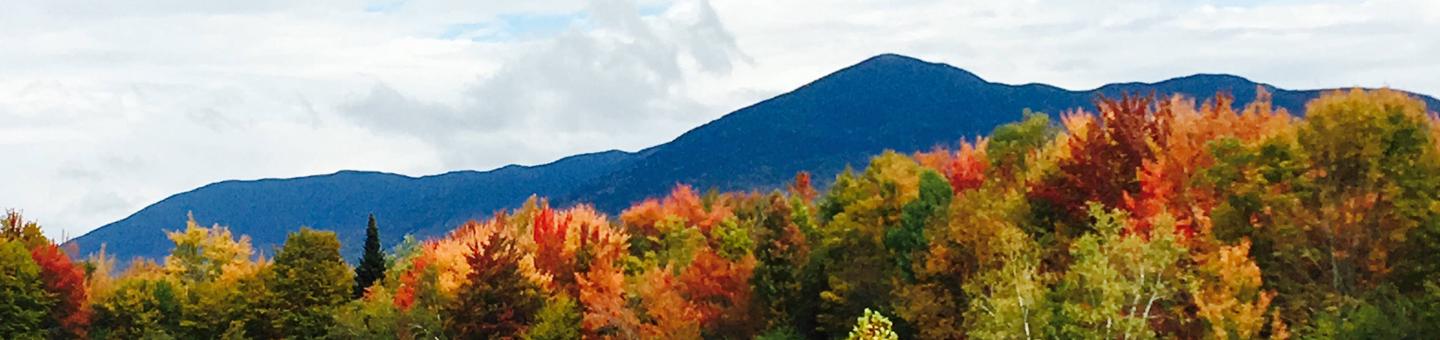

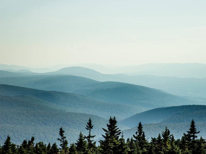
The Green Mountain & Finger Lakes National Forests’ scenic beauty along the backbone of Vermont’s Green Mountains and New York’s Finger Lakes region provide unlimited recreational opportunities in all seasons.
Go Play!


Some of the many opportunities we offer include:
- Over 900 miles of trails managed for both summer and winter uses
- Sections long trails like the Appalachian National Scenic Trail, the Long Trail, and the North Country Scenic Trail.
- Outsanding campgrounds, including two designated National Recreation Areas
- Eight designated wilderness areas on the Green Mountain National Forest
- 3 Alpine and 6 Nordic Commercial ski areas offering some of the most spectacular skiing in the northeast
- Countless lakes and streams for unlimited fishing and other water activities
Enjoy your Green Mountain and Finger Lakes National Forests. It’s All Yours!
RecAreaDirections
Open with Google Map
Misc
| Stay Limit | |
| Reservable | false |
| Keywords | |
| Map Link | |
| Contact Phone | |
| Contact Email |
Permits info
Facilities
Grout Pond Campground Campground
List of CampsitesOverview
Grout Pond is a popular destination for camping, hiking, paddling, and fishing. Located in a beautiful mixed conifer and hardwood forest, the campground has 12 reservable sites and offers easy access to over 10 miles of mulituse trails.
Recreation
Grout Pond offers a variety of recreation opportunities year-round. In the warmer months, fishing and non-motorized boating is popular on the pond. A 200-foot carry-in boat launch is accessible from an unloading pull-out just before the parking lot.
Please help prevent the spread of non-native invasive species, such as Eurasian watermilfoil, by cleaning and drying your boat between each use.
Hiking is another popular activity at Grout Pond. Over 10 miles of relatively flat trails are accessible from the campground. These trails connect with a more extensive system off National Forest lands around Somerset Reservoir to the south. Trails that are marked with blue diamond blazes are designed for cross-country skiing and can be very wet and muddy in the spring, summer, and even fall.
Facilities
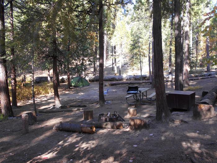
The campground offers 12 overnight sites available for reservation. Nine of these sites are tent sites accessed by hiking in from the main parking area. Hike-in distances vary from a quarter to three-quarters of a mile. Three campsites are drive-in sites that accomodate small RVs. The campground also offers two drive-in sites that are available on a first-come, first-served basis and cannot be reserved.
All campsites are outfitted with fire rings and several have picnic tables. Hike-in sites have tent pads; please use the tent pads in order to minimize camping impacts. Vault toilets are located off the main parking area and near the old cabin building. Potable water is available from an old-fashioned hand pump in the day use area near the pond.
Natural Features
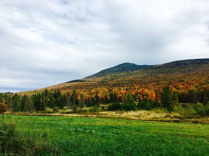
Grout Pond is 84 acres and 28 feet deep. The water can be chilly but refreshing on a hot summer day. The campground is located along the pond and is shaded by red maple, yellow birch and red spruce. Fall foliage viewing in the autumn months is excellent.
Nearby Attractions
Nearby attractions include hiking trails accessible from the site and paddling on the pond. The campground is also in close proximity to Appalachian/Long Trail trailheads off Kelly Stand Road and Stratton Mountain Resort and Village.
Blueberry Patch Campground Campground
List of CampsitesOverview
Blueberry Patch Campground is a small, semi-primitive campground located along Picnic Area Road (County Route 2), next to the large blueberry patch it received its name from. This is a popular spot to gather berries when they are in season. The berry patch features the high bush as well as low bush blueberries.
There are nine campsites available. Each has a fire pit, a tent pad, a picnic table, and parking for up to two cars. This campground is designed for tents or small campers under 24 feet long. Some of the picnic tables are handicap accessible. There are two handicap accessible vault toilets
HAPGOOD POND Campground
List of CampsitesOverview
Hapgood Pond Recreation Area and Campground is situated next to its scenic namesake pond, 13 miles east of Manchester, Vermont. Visitors enjoy camping, canoeing, kayaking, fishing, swimming, and hiking.Recreation
The Hapgood Pond is a popular place for non-motorized boating, including canoeing and kayaking. A carry-down launch area is located on the south end of the pond. Fishing and swimming are also favorite activities. Hapgood boasts the Forest's only designated and managed swim beach. A fishing pier is located on the south shore. Hapgood Pond Trail begins in the day-use area and continues almost a mile around the north edge of the pond to the dam. A short spur trail follows a stream and winds through the woods around the pond. Younger visitors love the big play field area within Hapgood, a perfect spot for Frisbee or ball games.Facilities
Hapgood Pond Recreation Area offers family campsites and day-use picnic shelters for groups. First come, first served sites are available. Vault toilets and drinking water are provided. Each family campsite is equipped with a picnic table, campfire ring with grill, parking spur, and a cleared area for a tent. Campsites 9-28 are reservable. Each group picnic shelter can accommodate up to 35 people, and is equipped with a pavilion, picnic tables, and a grill. The two shelters are available for reservations.Natural Features
Hapgood Pond Recreation Area is eight acres and is set in a wooded area in the northeastern portion of the Green Mountain National Forest, which encompasses over 400,000 acres in southwestern and central Vermont. Hapgood Pond covers another 12 acres which is perfect for swimming, boating, and fishing. The Green Mountain National Forests includes three nationally designated trails: the Appalachian Trail, the Long Trail, and the Robert Frost National Recreation Trail. The Forest also contains three alpine ski areas, seven Nordic ski areas, and approximately 900 miles of multiple-use trails.Nearby Attractions
The town of Manchester, Vermont, popular for its shops, restaurants, and other attractions, including the American Museum of Fly Fishing, is a short drive away.POTOMAC GROUP CAMPGROUND Campground
List of CampsitesOverview
Potomac Group Campground and Day Use Area provides a primitive camping experience for groups of 8-40 people. It is an excellent site for family events and youth group activities. The facility is situated in a scenic area of New York, which makes for an exciting place to explore. A variety of recreational activities are available. Parking for the campground is located approximately 500 feet from the campground itself and all gear must be carried in and out. Recycling cans are available on site but trash must be packed out.
Recreation
A variety of trails exist in the area, including the Potomac Trail, which extends about 5 miles round-trip. It is a moderately difficult trail that travels through a variety of forest types and follows the edges of quite a few ponds in the area. It is a nice loop on which to learn cross-country skiing and is also a popular game bird hunting area. The Potomac Trail connects with the Interloken Trail and the campground. Fishing is allowed in the ponds, pertaining to state fishing regulations.Facilities
Many primitive, group, tent-only campsites, and a group picnic shelter are available for reservation and equipped with at least 4 tables. A campfire circle and grills are also provided and vault toilets are located nearby. The shelter can accommodate up to 40 people and an adjacent parking lot can hold up to 10 vehicles. There is no electricity at the shelter. Drinking water is not available at the campground or picnic shelter, nor is trash collection.Natural Features
The lush, green campground is located in Finger Lakes National Forest, between Cayuga and Seneca Lakes in southwestern New York. It is New York's only National Forest. The Forest has over 30 miles of interconnecting trails that traverse gorges, ravines, pastures, and woodlands.Green Mountain - Middlebury/Rochester District Facility
The Middlebury/Rochester Ranger Districts are located in central Vermont.
Green Mountain - Manchester District Facility
The Manchester Ranger District is located in southwest Vermont, from the Massachusetts border north to Wallingford, VT.
Green Mountain National Forest - Manchester Ranger District Office Information
Address
2538 Depot Street
Manchester Center, VT 05255
Phone
1-802-362-2307
Moosalamoo National Recreation Area Facility
The Moosalamoo National Recreation Area, encompassing 15,857 acres, is a premier recreation destination that includes hiking trails, mountain bike trails, cross country ski trails, snowmobile trails, the Robert Frost Trail and camping areas at Silver Lake and Moosalamoo campgrounds.
Moosalamoo National Recreation Area Recreation Opportunity Guide
Silver Lake Campground Campground
List of CampsitesOverview
Silver Lake Campground is a small, primitive hike or bike-in only campground located on Silver Lake in Leicester, VT. There are 15 campsites, seven of which are available for advanced reservations along with eight first-come, first-served sites. It is a 0.6 mile hike in or a 1.5 mile bike ride in to access the campground.
Please note: This Silver Lake Campground is located in Vermont.
Recreation
The Moosalamoo National Recreation Area consists of 16,000 acres abounding with recreation opportunities. With over 70 miles of well-maintained trails, mountain vistas, waterfalls, lakes and streams, it offers opportunities for hiking, mountain biking, kayaking, swimming, fishing, hunting and more. From Silver Lake Campground, several hiking and mountain biking trails begin, including the Leicester Hollow / Chandler Ridge loop (open to hiking and biking) and the Rattlesnake Cliff / Aunt Jenny hiking loop (closed March 15 - August 1 for Peregrine Falcon nesting). Fishing and swimming are both popular activities accessible from the campground.
Facilities
There are two vault toilets and a spring (treat or boil water) within the campground. To access each campsite you must hike or bike-in, including all your gear. Each campsite has a fire ring, picnic table and a bear-proof food storage locker.
There is no garbage service available; please carry out what you carry in.
Natural Features
Silver Lake is a gorgeous 100-acre lake surrounded by National Forest on all sides. It has attracted people for many generations and, along with its natural beauty, holds a strong sense of history. Long before the famous Silver Lake Hotel and religious retreat located on the site of today's picnic area, ancestors of today's Abenaki people were here enjoying the peace and beauty.
Nearby Attractions
The nearest available shopping and dining is in Brandon, located nine miles from the campground. Also nearby is Middlebury (17 miles from the campground), which offers many additional options.
Bald Mountain Facility
The Bald Mountain trail provides a path for visitors to access the Glastenbury Wilderness and the summit of Bald Mountain. From the Bennington side, after climbing several hundred feet, hikers will reach the “white rocks” (not to be confused with the White Rocks National Recreation Area 40 miles to the north). This rocky opening on the west side of Bald Mountain provides excellent views to the west.
Trail Information
Bennington Side
The west side of the Bald Mountain trail (nearer Bennington) travels 4 miles, with 2000' elevation change, to the junction of with the West Ridge Trail. The trail travels under a powerline, through a tunnel under Route 279 and then follows an old woods road before entering the Glastenbury Wilderness on the Green Mountain National Forest in approximately one mile. The trail then climbs several switch backs and reaches the white rocks in 2.8 miles. The junction with the West Ridge trail is approximately 1 mile beyond the white rocks vista. The trail is marked with blue blazes.
Woodford Side
The east side of the Bald Mountain trail (nearer Woodford) travels 2 miles, with 1580' elevation change, to the junction of with the West Ridge Trail. The trail follows an old road that provides access for a few local camps and then at 0.3 miles, at the Forest Service boundary marked with red paint, turn left onto the trail. The trail climbs steadily and at 1.6 miles, the trail meets a spur trail leading to a seasonal spring at “Bear Wallow.” The trail reaches the West Ridge trail at 2 miles. The trail is marked with blue blazes.
Additional Resources
Bald Mountain Trail Brochure and Map
Robert T. Stafford White Rocks National Recreation Area Facility
Robert T. Stafford White Rocks National Recreation Area was re-named to honor the late Vermont Governor and Senator, Robert T. Stafford.
Chatfield Loop Facility
The trail begins on FR 67 (Brooks Road) at the Chatfield Parking Area. The trailis wide with gradual ascents and descents through various timber communities. Total loop distance is 12.5 miles and maximum elevation change is 400 feet. Average ride time is 3 – 4 hours.
Chatfield Loop Recreation Opportunity Guide
Mountain Biking Recreation Opportunity Guide
Forest Road 341 Facility
This road, also known as the International Paper or I.P. Road, can be accessed from the Stratton-Arlington Road (Kelley Stand Road) on the south and the Kendall Farm Road on the north. This road is open to mountain biking when not in use as a snowmobile trail. It is a 18.6-mile ride on a hard, gravel road surface that is rated moderate. Rules and regulations are posted by the New England Mountain Bike Association (NEMBA). Please adhere to these rules, so that the road can remain open for future use.
Forest Road 341 Recreation Opportunity Guide
Mountain Biking Recreation Opportunity Guide
Bingo Facility
General Forest Camping Recreational Opportunity Guide
Downingville Facility
General Forest Camping Recreation Opportunity Guide
Michigan Brook Road Facility
General Forest Camping Recreation Opportunity Guide
Romance Header Facility
General Forest Camping Recreation Opportunity Guide
Sparks Landing Facility
General Forest Camping Recreation Opportunity Guide
Steam Mill Clearing Facility
General Forest Camping Recreation Opportunity Guide
Texas Meadows Facility
General Forest Camping Recreation Opportunity Guide
West Hill (White River Road) & Patterson Brook Roa Facility
General Forest Camping Recreation Opportunity Guide
Old Job Facility
General Forest Camping Recreation Opportunity Guide
Old Job South Loop Recreation Opportunity Guide
Breadloaf Wilderness Facility
The largest of the Wildernesses in the Green Mountain National Forest, Breadloaf takes its name from Breadloaf Mountain, the highest point in the area at 3,835 feet. Within the boundaries you'll be able to climb Vermont's Presidential Range: Mounts Wilson, Roosevelt, Cleveland, and Grant. Although evidence of past logging operations can still be seen, the forest is quickly regenerating and numerous wildlife species take cover in these cutover sections. Moose and black bears live here in considerable numbers. Breadloaf contains the headwaters of the New Haven and White Rivers, both well stocked with small brook trout. The Norske Trail provides a primitive cross country ski or snow shoe experience.
Prospect Facility
Cross Country Skiing Recreation Opportunity Guide
Wild Wings Facility
Cross Country Skiing Recreation Opportunity Guide
Mt. Top Facility
Mt. Top
Rikert Facility
Rikert
Blueberry Hill Facility
Cross Country Skiing Recreation Opportunity Guide
Sugarbush Facility
Sugarbush
Mt. Snow Facility
Mt. Snow
Brandon Gap Facility
Brandon Gap
Lincoln Gap Road Facility
Lincoln Gap Road
Robert Frost Memorial Drive Facility
Robert Frost Memorial Drive
White River Road Facility
White River Road
Somerset Road Facility
Auto Foliage Tour Recreation Opportunity Guide
Joseph Battell Wilderness Facility
The Joseph Battell Wilderness is located in the northern half of the Green Mountain National Forest, just south of the Breadloaf Wilderness. There are five mountains in the area with altitudes exceeding 3,000 feet: Monastery Mountain, Worth Mountain, Romance Mountain, Mount Horrid, and Philadelphia Peak. The area is a rare ecological gem. It contains many patches of large, mature northern hardwoods, the longest section of roadless and trailless ridgeline on the Green Mountain National Forest, and the headwaters of Bingo Brook, one of the most pristine, high-quality trout streams in Vermont. Because of its remoteness, the area provides critical habitat for black bear. In addition, 17 rare, threatened, and endangered plant and animal species have been identified on Mount Horrid alone. Much of this wilderness was earmarked to be forever wild long before it was acquired by the Forest Service. The core of the area - Monastery Mountain to Worth Mountain to Romance Mountain - was bequeathed as a "park" to Middlebury College by Joseph Battell in 1915. In his will, Battell directed the trustees of these lands to "preserve as far as reasonably may be the forests of said park, and neither to cut nor permit to be cut thereon any trees whatsoever except such as are dead or down and such as it may be necessary to cut in making and repairing needful roads; it being a principal object of this [will] to preserve intact such wild lands as a specimen of the original Vermont forest." Middlebury sold nearly all of Battell's lands to the Forest Service in the 1930s and 1950s. Despite Battell's intentions, the college sold the lands without restrictions. It was the sale of these very lands that prompted the Federal government to create the northern unit of the Green Mountain National Forest
Middlebury Gap Facility
Middlebury Gap
Moses Pond Facility
Moses Pond
Falls of Lana Facility
Falls of Lana
Robert Frost Wayside Facility
Robert Frost Wayside
Big Branch Overlook Facility
Big Branch Overlook
Lye Brook Wilderness Facility
The Lye Brook Wilderness is east of Manchester Center in the southern Green Mountains of Vermont. This wilderness is named after Lye Brook, which flows through its western half. The wilderness ranges from 900 feet to 2900 feet above sea level. Most is above 2500 feet, on a high plateau with several ponds and bogs. Waterfalls and rocky streams may be found here as well as reflecting pools. The western section is extremely steep, facing west-northwest towards U.S. Route 7 and Manchester. Four and a half miles of the Appalachian/Long Trail cross the northwest tip of the wilderness. Approximately 80% of the area is forested with northern hardwoods: birch, beech, and maple. Thickets of small spruce dot the area. Remnants of railroad grades and old logging roads remain. Several species of neotropical birds, black bear, moose, deer, pine martin and bobcat inhabit these woods. There are many marshy areas off trail and the ecological balance is quite fragile. Take care and be prepared for muddy trails and an intense black fly season in the spring and early summer. Hunting opportunities for deer bring many seasonal visitors, as do snowshoeing and cross-country skiing in the winter months.
George D. Aiken Wilderness Facility
This wilderness was named after the late Vermont senator George D. Aiken. He was a strong advocate of preservation and a leader in securing the Eastern Wilderness Act of 1975. The Aiken Wilderness is situated on a plateau rising as high as 2,300 feet. General conditions are wet and marshy as the ground surface of the Aiken Wilderness is covered with a great deal of water. In spring and summer, be prepared for swarming mosquitoes and black flies. Beavers are very active here, chewing trees down to stumps and building dams. Brook trout live in their ponds and make for excellent fishing opportunities. Bears, moose, deer, otters, and many smaller mammals and birds share the area. Although not mountainous, this land of ponds, meadows, and brushy forest is purposely managed without established trails. Old logging roads, evident in some places, disappear quickly. Bushwhacking can be tough but worth a compass adventure.
Bristol Cliffs Wilderness Facility
Bristol Cliffs, Vermont's smallest Wilderness, takes its name from the overhanging cliffs on the huge rocky slopes within the western portion of the area. From their 1,500-foot summit, you can gaze across Champlain Valley, over Lake Champlain, and into the Adirondacks of New York. A bulge of quartzite called Devil's Pulpit, probably used by early Native American toolmakers, dominates the cliff face. The face is considered unsafe for climbing. The forest of Bristol Cliffs provides habitat for beavers, white-tailed deer, black bears, and grouse. If you're lucky, you might spot a peregrine falcon on the cliffs. Two secluded ponds, North and Gilmore, are nestled deep in the interior. Numerous streams tumble musically over low waterfalls. The area has no established trails, and the occasional footpaths to the cliffs are faint and hard to follow. But with a map and compass in hand, you can explore the area and find one of the least visited spots in Vermont.
Big Branch Wilderness Facility
Named after Big Branch Stream, this area provides a home for wild turkeys, beavers, and moose. Hunters track the substantial populations of white-tailed deer and black bears, while trout lure anglers to Big Branch Stream and Lake Brook. Approximately 80 percent of the forest leafs out in northern hardwoods--maple, beech, and birch--and straddles the steep slopes and summits of the Green Mountains. Red spruce, balsam fir, and hemlock pretty much fill out the rest of the trees. Elbow Swamp, a large wetland, lies on the eastern edge of the Wilderness, and hikers who intend to wander there should wear rubber boots. The weather is cool from spring through fall, followed by long, snowy winters that attract cross-country skiers. The Appalachian Trail/Long Trail crosses the area for approximately five miles and, with side trails, allows you to explore Big Branch with numerous camping opportunities. Climbing up to Baker Peak is a rewarding view. Bring a map and compass and wander off-trail for a more vivid Vermont Wilderness experience.
Peru Peak Wilderness Facility
Resting just east of Big Branch Wilderness, Peru Peak Wilderness takes its name from the highest mountain in the area. In the more remote, trailless northern half stands Pete Parent Peak, a 3,000-footer that, unlike most in Vermont, has no marked path to the top. Brook trout can be found in the numerous ponds and streams. Black bear and white-tailed deer attract hunters in the fall. Deer are more numerous in the eastern section along Utley Brook. Cross-country skiers like the deep, hard snow deposited in winter. The Appalachian Trail/Long Trail crosses the southern end of the Wilderness for about three miles, taking in the summits of Peru and Styles Peak, both topping 3,000 feet. Styles Peak provides the best view.
Glastenbury Wilderness Facility
The Glastenbury Wilderness is northeast of Bennington, beginning just north of Route 9. Seen from Route 7, the area possesses a massive and beautifully wild ridgeline that dominates the landscape to the east. Despite the area's proximity to Bennington, it is quiet and remote. The forestland and extensive stands of mature beech trees provide critical black bear habitat, and claw-marked beech trees are a common sight demonstrating the presence of bears throughout the area. The Vermont Fish and Wildlife Department has identified Glastenbury as a region "supporting relatively high densities of cub-producing females, and an area containing critical habitats necessary to bear survival." The rich forest habitat of the Glastenbury area is home to a wide variety of birds. The presence of Bicknell's thrush (designated in Vermont as rare and of special concern) has been documented as well as Swainson's thrush, yellow-rumped warbler, Cape May warbler, winter wren, dark-eyed junco, and white-throated sparrow. Glastenbury offers extensive opportunities for backcountry recreation. The hilly terrain of the area includes several summits surpassing 2,000 feet and Mt. Glastenbury is over 3,700 feet in elevation. More than fifteen miles of trails offer access to hikers, snowshoers, and cross-country skiers. The Long Trail/Appalachian Trail crosses the entire area from north to south by an old fire tower on the top of Glastenbury Mountain. Hell Hollow Brook, in the southern edge of the area, contributes to the public water supply of Bennington. The township of Glastenbury is almost entirely National Forest, but for much of the last one hundred years it was owned by one family. The timber magnate Trenor W. Park passed Glastenbury along to his grandson, Hall Park McCullough, whose grandson, Trenor Scott, sold most of his holdings to the Forest Service. A century ago, Glastenbury was completely clearcut to supply vast quantities of charcoal to the iron industry in nearby Shaftsbury and Troy, New York. Glastenbury is now a rich mosaic of balsam fir, red spruce, white and yellow birch, beech, and mountain ash. It is interspersed with patches of ferns, raspberries, blackberries, bluebead lily, and dwarf dogwood. It now supports mature forest.
Shep Meadows Facility
Shep Meadows
Backbone Horse Campground Campground
List of CampsitesOverview
Backbone Horse Campground is a small, semi-primitive campground designed primarily for campers or picnickers that bring horses with them.
Finger Lakes - Hector District Facility
The Finger Lakes National Forest, positioned along the ridges between Cayuga Lake and Seneca Lake, offers scenic beauty and unlimited recreational opportunities any season of the year. Whether you are a hiker, cross country skier, camper, fishing or hunting enthusiast, snowmobiler, horseback rider, mountain biker, or wildlife watcher, the Forest can provide the recreational experience you are seeking!
The most popular season is autumn when the trees and pastures are ablaze with color. Hunter ejoy the woods and brush lands of the forest during this time. Summer is a popular time for camping, hiking, horseback riding, bicycling, and fishing. Winter brings out cross country skiers, snowmobiles, and snowshoe enthusiasts. In spring, the Forest bursts forth from the grip of winter with emerging leaves on the trees, bird flyway activity, and numerous wildflowers that are visible along many of the Forest trails and pastures. The first fishing days are enjoyed by a lot of people.
Spring is also mud season, which is usually short but intense. Going "off-road" and hiking on wet trails is not encouraged during this time.
Finger Lakes National Forest - Hector Ranger District Office Information
Address
5218 State Route 414
Hector, NY 14841
Phone
1-607-546-4470
