
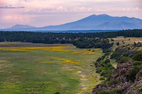
Coconino National Forest Recreation
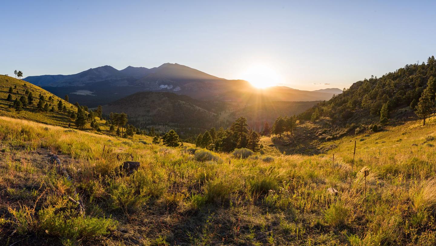


The Digital Travel Map is a free resource for anyone headed out into the Coconino National Forest. Whether you're driving, hiking, riding, or exploring, you will find this full color, GPS-enabled map a handy reference to have on your mobile device. The map show trails, recreation sites, major landmarks, and forest boundaries in addition to the roads shown on the Motor Vehicle Use Map.
See Maps and Publications for more digital and printed maps.
Some tips to help you enjoy your recreation experience...
- Fireworks are not allowed on the National Forest.
- Winter brings snow to the high country. Be avalanche aware!
- When camping or picnicking, please keep your site clean, free from trash and food. Otherwise animals and insects are attracted to your site.
- Bag your trash and take it home with you. Help us keep our forests clean and green by "Packing It Out!"
- Never leave your campfire unattended. When you leave, put it out, dead out! See Forest Orders for any current fire restrictions
- Human waste is a big problem when thousands of people converge on the Forest. Please see Leave No Trace - Dispose of Waste Properly for detailed instructions on handling this "delicate" situation.
Sharing the trail with horses
“What a Horse Sees!” – a short film illustrating safe ways of passing horse and rider on the trail. [Trailmeister.com]
Driving motorized vehicles on the Forest
Keep motor vehicles on designated routes and areas. If you plan on camping, driving off-highway vehicles, hunting, or exploring the backcountry, get a free Motor Vehicle Use Map (MVUM) to know which roads are open to motor vehicle use. Know before you go.
Where do recreation fees go and how are they used?
Take a moment to view the latest Recreation Fee Accomplishment Report, which shows the revenue and expenditures, as well as how fees were put to good use!
With your help, we can protect our natural resources for future generations. Thank you!
RecAreaDirections
Open with Google Map
Misc
| Stay Limit | |
| Reservable | false |
| Keywords | |
| Map Link | |
| Contact Phone | |
| Contact Email |
Permits info
Facilities
Coconino National Forest Christmas Tree Permit Tree Permit
Moqui Group Campground Campground
List of CampsitesOverview
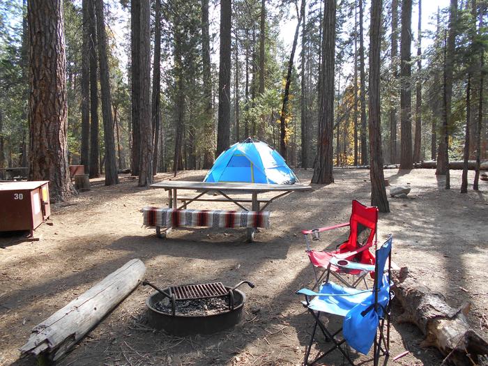
The Moqui Group Campground sits in a beautiful setting surrounded by ponderosa, oak, and aspen at an elevation of 6,915'. The campground consists of 3 individual group sites: Simmons, Spooner, and Ernst. Each site can accomodate up to 50 people offering picnic tables, fire rings, grills, vault tolets, trash collections, and piped drinking water. For groups larger than 50 people, multiple sites can be reserved. The Simmons and Spooner Group sites can each accomodate a maximum of 3 trailers or RV's up to 22'. The Earnst Group site is best suited for tents and smaller equipment.
Recreation
Many visitors spend time relaxing and exploring the area. The nearby C.C. Cragin Reservoir and Knoll Lake offer opportunities for water based recreation, while the Arizona National Scenic Trail, General Crook National Recreation Trail, and historic Cabin Loop Trail System offer opportunities for hikers, bicyclist, and equestrian users. There are also several Fire Lookout Towers in the area.
Facilities
The group sites include fire rings, grills, picnic tables, vault toilets, trash collection, and piped drinking water.
Natural Features
The campground is in a forested setting. The nearby Mogollon Rim is one of the most striking geologic features in the state. This steep escarpment, measured in thousands of feet, stretches from New Mexico diagonally accross two thirds of Arizona and offers sweeping views of the landscape.
Nearby Attractions
The community of Happy Jack, Arizona has a gas station, two convenience stores and two restaurants.
Long Valley Group Campground Campground
List of CampsitesOverview
The Long Valley Work Center Group Campground sits among stately ponderosa pines at an elevation of 6,950 feet offering a cool respite from the summer heat of the valley below. It is also the site of a historic Forest Service work center. The campground is designed to meet the needs of large groups and can accommodate 100 people, offering picnic tables, grills, and a large fire pit. There are vault toilets. For every 25 people after the first 50, the group will need to provide additional port-a-pots.
Recreation
Many visitors spend time relaxing and exploring the area. The nearby C.C. Cragin Reservoir and Knoll Lake offer opportunities for water based recreation, while the Arizona National Scenic Trail, General Crook National Recreation Trail, and historic Cabin Loop Trail System offer opportunities for hikers, bicyclist, and equestrian users. There are also several Fire Lookout Towers in the area.
Facilities
The group campground is in a primitive setting on 5 acres. The site has grills, picnic tables, a large fire ring, trash collection and vault toilets. It is important to know that for every 25 people after the first 50, the group will need to provide additional port-a-pots. The site can accomodate up to 100 people and 50 vehicles.
Natural Features
The campground is in a forested setting adjacent to a meadow. The nearby Mogollon Rim is one of the most striking geologic features in the state. This steep escarpment, measured in thousands of feet, stretches from New Mexico diagonally across two thirds of Arizona and offers sweeping views of the landscape.
Nearby Attractions
The community of Happy Jack, Arizona has a gas station, two convenience stores and two restaurants.
Palatki Heritage Site Tours Ticket Facility
Ancient Cliff Dwelling and Pictographs Sheltered by Colorful Cliffs of Red Canyon. In addition to the ticket, an interagency (IA) or Red Rock Pass is required for entry and may be purchased on site. To purchase an Interagency Pass: • In person: Find a location to purchase this pass at a federal recreation site. • Online: Buy this pass from the USGS Store. • By phone: Call 888-ASK USGS (1-888-275-8747), extension 2. Hours of operation are 8 am to 4 pm Mountain Time. To purchase a Red Rock Pass: • In person: Where to buy a Red Rock Pass • Online: Buy a Red Rock Pass from Rcreation.gov Located northwest of Sedona, Arizona, the Palatki Heritage Site is one of the largest cliff dwellings of the Red Rock Country between C.E 1150-1350. The dwelling stands much as described and photographed by Dr. Jesse Walter Fewkes, in 1895 from the Smithsonian Institution, who gave them name of Palatki, Hopi for Red House. In addition to the excellently preserved dwelling, there is “Rock Art”, Pictographs and Petroglyphs indicating that the area has been utilized by people as far back as 12,000 B.C.E. Many cultures left their “marks” through the ages for you to experience up close. To protect these sites, we have experienced guides who will assist you in understanding the people who lived here and their cultures. The main tour for the site includes the Dwelling and the “Grotto” “Rock Art” site. These 1-hour tours leave the visitor center every half hour starting at 9:30AM and the last tour leaves at 2:00PM, expect to spend 1 1/2 hours on site. The tours are offered 7 days a week. Total walking distance for the basic tour is 1 mile which includes 60 fairly strenuous, uneven steps to the Dwelling site. Please know your limitations An extended tour, of the area includes the Bear Alcove, Water Catchment and Roasting Pit area in addition to the basic tour. Including the Basic tour this tour lasts 2 hours and is led by a guide.
Rock Crossing Campground (AZ) Campground
List of CampsitesOverview
The Rock Crossing Campground sits in a beautiful setting surrounded by ponderosa pine and oak at an elevation of 7,316'. The cool summer climate and countless recreational opportunities makes this a popular location.
Wildlife is abundant in the area and includes elk, mule deer, black bear, bald eagles, and osprey.
Recreation
Many visitors spend time relaxing and exploring the area. The nearby C.C. Cragin Reservoir and Knoll Lake offer opportunities for water based recreation, while the Arizona National Scenic Trail, General Crook National Recreation Trail, and the historic Cabin Loop Trail System, offer opportunities for hikers, bicyclist, and equestrian users. There are also several Fire Lookout Towers in the area.
Facilities
The campground is comprised of 31 individual family sites and two double sites. Each family site can accommodate up to eight people while double sites can accommodate up to 16 people. The facility provides picnic tables, campfire rings, cooking grills, tent pads, bear food storage lockers, drinking water, vault toilets, trash collection, and campground hosts. There are no utility hookups or showers.
Campsites vary in size and can accommodate a wide range of equipment with a maximum RV or trailer length of 32'.
For groups larger than 10 people and up to 50 people, the nearby Moqui Group Campground can be reserved.
Natural Features
Coconino National Forest offers 1.8 million acres of recreational opportunity from desert basins to mountain peaks. The campground sits in a forested setting. The nearby Mogollon Rim is one of the most striking geologic features in the state. This steep escarpment, measured in thousands of feet, stretches from New Mexico diagonally across two thirds of Arizona and offers sweeping views of the landscape.
Nearby Attractions
Tonto Natural Bridge State park is approximately 45 minutes away and offers what may be the world's largest travertine bridge. The community of Happy Jack, Arizona has a gas station, two convenience stores and two restaurants.
Lakeview Campground (AZ) Campground
List of CampsitesOverview
Lakeview Campground is a tent camper's paradise with its terraced hillside campsites tucked in amongst old ponderosa pines. With all the easy forest and lake access, this is also a great place for wildlife watchers. Many visitors report seeing bald eagle, osprey, migratory waterfowl, great blue heron, elk and mule deer.
Recreation
Ideal for hiking, bird watching, fishing, wildlife watching.
Facilities
The campground has 30 campsites. 15 sites are reservable and 15 sites are dedicated as first-come-first-served sites. Each site has provided picnic tables, fire rings and cooking grills. The campground provides drinking water, has accessible vault type toilets and a boat ramp for universal access fishing at Lake Mary picnic area. Wood memorial trail links Lakeview campground with Lake Mary picnic area. Trash service is provided for campers only. Lakeview campground is pet friendly. Pets must always be restrained or on a leash. Camp host lives on site.
Natural Features
Woodland environment with gravel roads and gentle hillsides. Glimpses of beautiful Lake Mary can be enjoyed through the abundant pine.
Nearby Attractions
Lake Mary provides many water activities for kayakers, boaters and is very popular for paddle boarding. The Lake Mary picnic area is a comfortable and beautiful spot to enjoy the lake.
CLEAR CREEK GROUP (AZ) Campground
List of CampsitesOverview
This cozy group campground is tucked in the Lower Sonoran Desert along the banks of the fresh, chilly Clear Creek. Campers can wade in the creek, fish, or curl up with a book under the umbrella of cottonwood trees. Another popular pastime here is birdwatching, where you might just spot a hawk or bald eagle in flight.Clear Creek Campground is seven miles southeast of the small ranching town of Camp Verde. It's part of the Coconino National Forest, one of the most diverse forests in the country. Landscapes range from alpine tundra to desert valleys and red canyons.
Recreation
The campground is part of an oasis that attracts a variety of wildlife. Colorful songbirds and raptors are common birdwatching finds, and cool water species such as smallmouth bass and green sunfish make for enjoyable fishing. Wildlife watching includes black bears, elk, turkey, deer, and bison.Facilities
Clear Creek Campground is grassy and flat, with some shade from surrounding cottonwoods. The group campsite holds 80 people with a maximum of 30 vehicles. The campsite is a popular destination, with its relaxed, open atmosphere, so be sure to book early for holiday weekends. This facility also has 18 standard family sites available on a first-come, first-served basis.Natural Features
Clear Creek sits in the Verde Valley at 3,200 feet elevation. It's part of the Sonoran desert near the base of Cactus Mountain, and the climate is arid with hot summer days and mild winters.Nearby Attractions
A must-do day trip is the Montezuma Castle National Monument, where you can marvel at a well-preserved Native American cliff dwelling that dates back 1,000 years. Near the dwelling is the Montezuma Well, which is a naturally-formed well that collects over a million gallons of fresh water a day.Hot-air ballooning and horseback riding are also fun outings near the campsite.
CHAVEZ CROSSING Campground
List of CampsitesOverview
Chavez Crossing Group Campground is in the picturesque Red Rock district of Arizona, with famous red rock formations and breathtaking painted sunsets. Placed beside a creek and surrounded by sycamore and cypress groves, the campground's location offers a fresh sense of the great outdoors. It's also conveniently close to developed entertainment like golf courses and stylish restaurants in the resort town of Sedona. Drive through Oak Creek Canyon to view majestic red-hued cliffs, buttes, and canyons. At night, relax by the campfire at your site or take advantage of Sedona's trendy shopping and nightlife.Recreation
Go wading or fishing in the crystal clear waters of Oak Creek or take a stroll with your camera to photograph the unique flora, fauna and rock formations. Cathedral Rock and Bell Rock are famous nearby attractions, perfect for exploring or photographing.Facilities
The campground's location makes it a convenient place to mix outdoors time with shopping trips in the resort town of Sedona. Three group sites are available, and all three can be reserved for a total capacity of 110.Natural Features
Chavez Crossing is in a high desert region situated at the base of the Mogollon Rim, a 200-mile long slope that ranges between 5,000 and 7,000 ft elevation. The unique landscape creates erosion that has shaped spectacular canyons and buttes that make the region an appealing attraction.Nearby Attractions
A variety of hiking trails and swimming holes are a short drive away. Seek out your favorite panoramic views at Munds Mountain Wilderness, or explore the Red Rock/Secret Mountain Wilderness area in the heart of Oak Creek Canyon. Here, you can find abandoned dwellings and rock art from early inhabitants.DAIRY SPRINGS Campground
List of CampsitesOverview
Dairy Springs is a comfortable campground tucked away in a scenic area of northern Arizona. Its main attraction is the seasonal Mormon Lake which, when filled with water, draws visitors for fishing, windsurfing and wildlife watching.Hiking, biking, horseback riding and photography are available year-round. The facility has both individual and group sites that can accommodate groups of many sizes, including large families.
Recreation
Recreation usually centers around fishing in nearby Mormon Lake (seasonally). The area is ripe with additional outdoor activities. Three hiking trails originate at Dairy Springs and one at nearby Double Springs. The trails lead to scenic overlooks of Mormon Lake and surrounding prairies, forests and volcanoes.Wildlife watching is also popular. It's a very good place to spot hawks, including northern harriers and ospreys. The area boasts a healthy population of elk and mule deer too.
Facilities
The moderate-sized campground has 30 single unit campsites with tables and cooking grills, in addition to two group sites that can each hold 40 people and may be reserved at the same time for a group of up to 80 campers.
Campsites are nicely spaced with plenty of room and shade. Visitors can walk along a self-guided nature trail or attend a campfire program at the facility's amphitheater.
Fifteen single unit sites are available at the adjacent Double Springs Campground by reservations only.
Natural Features
Dairy Springs sits in a picturesque forest of old Ponderosa pine and oak trees with a grassy understory. The campground is at an elevation of 7,100 ft. and has summers that are characteristically sunny, warm and dry, with the occasional afternoon thunderstorm.Dairy Springs is adjacent to Double Springs Campground, which has a spring that runs to the surface just above the camping area.
Nearby Attractions
The closest town is Mormon Lake, Arizona. This small and scenic mountain resort village is conveniently close to the campground and offers horseback rides, mountain bike rentals, a country store, service station and steakhouse.PINEGROVE Campground
List of CampsitesOverview
Pinegrove Campground sits in the lush Coconino National Forest of northern Arizona, offering visitors countless recreation opportunities set in a stunning landscape.Recreation
Nearby Upper and Lower Lake Mary, Ashurst, Marshall and Kinnikinick Lakes serve as a recreational focus for this campground. All are stocked with fish including trout, bass and channel catfish. Upper Lake Mary is popular with power boaters, and Ashurst attracts a following of windsurfers along with anglers and boaters.Several excellent hiking and biking trails are located within a short drive. Visitors also enjoy wildlife viewing and picnicking.
Facilities
The campground is comprised of 46 spacious individual sites. The facility provides coin-operated showers, picnic tables, campfire rings, cooking grills, drinking water and accessible flush toilets.There are boat ramps at the lakes, as well as accessible fishing access at Lake Mary Narrows.
Natural Features
Coconino National Forest's 1.8 million acres offer clear lakes, red rock cliffs, desert basins and canopies of pine trees.The lakes around these forested campgrounds are used as a stopover for migrating waterfowl, a wintering site for rare bald eagles and a feeding ground for resident ospreys. The area is also home to a considerable number of elk and mule deer.
Nearby Attractions
The nearest town is Flagstaff, Arizona, about 20 miles away. Camping supplies, groceries, gas, restaurants, shopping and more are available.CAVE SPRING Campground
List of CampsitesOverview
Cave Springs sits in the scenic Oak Creek Canyon and is one of Coconino National Forest's most popular campgrounds.The campground is nestled in a forested canyon near the town of Sedona, Arizona, and its famous red rock cliffs. The scenery is unmatched, the stream is stocked with trout, and swimming, hiking and birding spots are nearby.
Recreation
There are several hiking trails in the vicinity. Some lead up the canyon slopes to offer good views of the surrounding scenery. The creek is bordered with paths that lead along its picturesque course, offering great bird watching and fishing.Facilities
Cave Spring is a large campground with 84 campsites, including one tent-only site. All sites have picnic tables, campfire rings and cooking grills. Token-operated showers, drinking water and vault restrooms are provided for convenience. The facility can host RVs, trailers and motor homes up to 36-ft.Natural Features
The area is a heavily wooded, lush riparian zone. Campsites are located in a shady stand of ponderosa pines in the upper reaches of the canyon. Many of the campsites are located right on the banks of Oak Creek. The creek has crystal clear, cool water that is refreshing on hot summer days.Nearby Attractions
The nearest town is Sedona, popular for its red rock vistas, resorts and shopping. One of Arizona's best swimming spots, Slide Rock State Park, is down the road.Campers can also explore the 1.8-million acre Coconino National Forest, which boasts a spectacular variety of scenery and outdoor activities.
LITTLE ELDEN SPRINGS HORSECAMP Campground
List of CampsitesOverview
Little Elden Springs Horse Camp is a campground that was created for those who love horses and enjoy riding in a beautiful landscape. Located in the Coconino National Forest of northern Arizona, the campground offers opportunities for horseback riding, hiking and wildlife viewing.The facility is very accommodating to campers and their horses and including hitching posts, plenty of space for horse trailers and access to over 30 miles of trails.
Recreation
Campers can access the Kachina Peaks Wilderness at the Weatherford Trail near Schultz Tank just up the road from the campground.The Mount Elden/Dry Lake Hills Trail System is also accessible right from camp and is comprised of over 30 miles of trails for all levels of horseback riding, hiking and mountain biking.
Some of the nearby trails offer amazing views of the peaks, especially during the changing of the leaves in the fall when the aspens turn from green to gold.
Facilities
This campground is only available to campers with horses, and has been designed for the particular needs of equestrian campers. All 15 campsites allow easy access for vehicles pulling horse trailers and are equipped with horse-friendly accommodations. Two hitching posts are provided per site, and extra parking is available. Manure removal is the responsibility of the owners.The restroom is accessible, though there are no accessible sites.
Stalls or corrals are not provided.
Natural Features
The campground lies near the base of Mount Elden in a lush ponderosa pine and gamble oak forest and has a view of the 12,000-ft. San Francisco Peaks. Fall foliage can be outstanding and very inviting for photography. There is a healthy population of mule deer and elk in the area that can be fun to watch and photograph when sighted.Summers are very pleasant with sunny skies, high temperatures in the 60s to 80s and occasional afternoon thunderstorms.
Nearby Attractions
The nearby town of Flagstaff, Arizona, has shopping, restaurants and other conveniences. Visitors can also make a quick trip down the road to the must-see Sunset Crater Volcano National Monument and Wupatki National Monument.CRESCENT MOON Campground
List of CampsitesOverview
Crescent Moon sits beneath the towering Cathedral Rock, one of the most photographed scenes in the Southwest. This day-use area (group shelter also known as Ramada) is as popular as it is beautiful. Visitors will marvel at the reflection of the red cliffs in the waters of Oak Creek at Red Rock Crossing.Recreation
Visitors enjoy picnicking, fishing and wading in the crystal clear waters of Oak Creek. Flora, fauna and rock formations in the surrounding area offer excellent photography opportunities.Within a few minutes, visitors can access hiking, biking and scenic driving through Oak Creek Canyon to view majestic red-hued cliffs, buttes and canyons. The site is also conveniently close to developed entertainment like golf courses and stylish restaurants in the resort town of Sedona.
Facilities
The scenery is the biggest draw to the facility. The group picnic shelter (also known as ramada) has picnic tables and grills and can accommodate up to 50 guests. There is ample parking around the site. Drinking fountains are provided.Natural Features
Placed beside a tree-lined creek, the picnic area's location offers a serene place to enjoy nature, with Sedona's famous red rock cliffs setting the backdrop.Crescent Moon lies in a high desert region situated at the base of the Mogollon Rim, a 200-mile long slope that ranges between 5,000 and 7,000 feet in elevation. The unique landscape creates erosion that has shaped spectacular canyons and buttes that make the region an appealing attraction.
Nearby Attractions
The towns of Sedona and Oak Creek offer plenty of lodging, camping, shopping and dining to entertain guests.A variety of hiking trails and swimming holes are a short drive away. The Red Rock/Secret Mountain Wilderness area in the heart of Oak Creek Canyon is a popular destination, where visitors will find abandoned dwellings and rock art from early inhabitants.
PINE FLAT CAMPGROUND WEST Campground
List of CampsitesOverview
Pine Flat Campground is a popular camping spot in scenic Oak Creek Canyon in Arizona's Coconino National Forest.The campground is nestled in a forested canyon near the well-known town of Sedona, Arizona, and its red rock cliffs. The scenery is unmatched, the stream is stocked with trout, and swimming, hiking and birding spots can be accessed from the facility.
Recreation
There are several hiking trails in the vicinity, with some leading up the canyon slopes to offer sweeping views of the surrounding scenery. The creek is bordered with paths that lead along its picturesque course, offering excellent birding and abundant fishing.Facilities
There are 59 single unit sites at Pine Flat Campground, including two accessible sites. Picnic tables, campfire rings and cooking grills, as well as vault restrooms and drinking water, are provided. No hookups or showers are available.
Natural Features
The area is a heavily wooded, lush riparian zone. Campsites are located in a shady stand of ponderosa pines in the upper reaches of the canyon. Many of the campsites are located right on the banks of Oak Creek. The creek has crystal clear, cool water that is refreshing on hot summer days.Nearby Attractions
The nearest town is Sedona, popular for its red rock vistas, resorts and shopping. One of Arizona's best swimming spots, Slide Rock State Park, is down the road.Campers can also explore the 1.8-million acre Coconino National Forest, which boasts a spectacular variety of scenery and outdoor activities.
CRESCENT MOON RANCH CABIN Campground
List of CampsitesOverview
Crescent Moon Ranch is an exceptional year-round place to stay in beautiful Sedona. The central Arizona facility is a rustic, historic ranch house adjacent to Oak Creek and near the base of the towering Cathedral Rock, one of the most photographed scenes in the Southwest. Guests can enjoy hiking, photography or simply relaxing and taking in the breathtaking views.The cabin can accommodate up to 10 people for overnight use. It can be accessed by vehicle. Guests are responsible for their own travel arrangements and safety, and must bring several of their own amenities.
Recreation
Guests can picnic at the adjacent day use area and fish, swim and wade in the crystal clear waters of Oak Creek. Flora, fauna and rock formations in the surrounding area provide excellent subjects for photography.Within a few minutes, visitors can access hiking, biking and scenic driving through Oak Creek Canyon, to view majestic red-hued cliffs, buttes and canyons. The site is also convenient to Sedona, a resort town with shopping, dining, golfing and other attractions.
Facilities
With three bedrooms, three bathrooms, a large living room, two kitchens and an enclosed sun porch, Crescent Moon offers plenty of room. The house has beds with mattresses, and a futon and sleeper sofa in the living room. Electricity and running water are provided, and the house has heating and air conditioning, providing a comfortable stay any time of the year. Please be mindful of reducing heating and cooling cost by not leaving windows open with central heating/cooling system running. The house is fully furnished, including a dining room table and chairs. The large kitchen has a sink, electric stovetop range, dishwasher, refrigerator, coffee maker, toaster, crock pot, electric can opener and microwave. There is a limited supply of plates, pots and pans, and silverware. The smaller kitchen has a sink, cupboard storage and extra counter space. A grill and picnic table sit outside for outdoor cooking ( click here for more cabin details ). Guests must bring their own bedding and pillows, flashlights, towels, food, garbage bags, dish soap, dish towels, extra cooking utensils and dishes, toilet paper and paper towels. Bedding and linens are not provided. Three full beds, one with a twin bunk and two full futons are in the living room. Guests must clean the cabin completely and pack out all food and trash before leaving. Some cleaning supplies are provided.Natural Features
Placed beside a tree-lined creek with Sedona's famous red rock cliffs in the background, Crescent Moon's location offers a serene natural setting. The site lies in the high desert at the base of the Mogollon Rim, a 200-mile slope that ranges between 5,000 and 7,000 feet in elevation. Cresent Moon sits at an elevation of 4,000 feet and was built by ranchers of the original homestead. The cabin was later made available for public use by the U.S. Forest Service.Nearby Attractions
The nearby towns of Sedona and Oak Creek offer plenty of lodging, camping, shopping and dining. A variety of hiking and swimming destinations are within a short drive, including the well-known Slide Rock State Park and Red Rock/Secret Mountain Wilderness area.OLEARY GROUP SITE Campground
List of CampsitesOverview
O'Leary Group Campground was constructed in 2001 and is named for O'Leary Peak, which overlooks this site. The campground is designed to accommodate the special needs of large groups with everything from picnic shelters, tables and grills, to lots of level ground covered in native volcanic cinders, perfect for setting up tents.Its proximity to Sunset Crater Volcano and Wupatki National Monuments make it especially suitable for visitors who are intrigued by the cultural and natural history of the area.
Recreation
Most visitors spend time hiking, exploring and learning at the national monuments. Sunset Crater and Wupatki National Monuments have visitor centers and feature self-guided and ranger-guided tours.Another popular activity is hiking to O'Leary Lookout Tower. The trail is 4.9 miles one way on an old forest road with a steady, steep climb that rewards visitors with a vast panoramic view of Flagstaff, the San Francisco Peaks and the Painted Desert which was carved out by the Little Colorado River.
Facilities
There are three group camping areas. The east and north loops can each accommodate up to 50 people, while the west loop can host up to 75 people. Camping areas are spacious. The facilities offer many amenities for hosting large group gatherings, such as electricity, trash collection and drinking water.Natural Features
The campground sits on a bed of soft, flat volcanic soil amidst Arizona's ponderosa pine country. This area of volcanic activity is so unique that much of it has been set aside as Sunset Crater National Monument.The camping area offers incredible views of dark cinder cone peaks, thick forests and open grassy meadows that burst with wildflowers in spring and early summer.
Wupatki National Monument is also nearby and features an ancient four-story pueblo, a masterpiece of Ancient Pueblo stone masonry circa A.D. 1120.
Nearby Attractions
The nearby town of Flagstaff, Arizona, has shopping, restaurants and other conveniences.Visitors also frequent the must-see Sunset Crater Volcano National Monument and Wupatki National Monument.
MANZANITA. Campground
List of CampsitesOverview
Manzanita Campground is a small, year-round, tent-only facility with campsites that fill up very quickly. Visitors enjoy the campground for its fishing and swimming holes along Oak Creek, beautiful scenery and excellent wildlife watching. Oak Creek Canyon is very crowded, especially on weekends; to get a campsite, it is best to reserve a weekday.Recreation
Recreation and relaxation abound in Oak Creek Canyon. Camping, fishing, swimming, wading and hiking are some of the activities awaiting visitors. Anglers have the convenience of creekside campsites, where they can cast a line for trout.Families love driving down the road to nearby Slide Rock State Park, one of Arizona's most popular swimming spots, or trying out several nearby hiking trails.
Facilities
The campground is very easy to access and has paved parking. It is made up of single-family campsites that are fairly close together. Each site has a picnic table, campfire ring and grill. A campground host is available for visitor assistance. Firewood can be purchased on-site.
Campground has 4 first-come-first-serve sites which are often occupied. Campground host is unable to "hold" any first-come-first-serve sites for customers.
Natural Features
The campground borders Oak Creek in a lush, forested riparian zone with Arizona ash and box elders, gravel beaches and stream-bed boulders. Colorful songbirds add flashes of brilliance to the trees. The creek's crystal clear waters are cool and refreshing on hot summer days.Nearby Attractions
The well-known town of Sedona is popular for its red rock vistas, resorts and shopping. Slide Rock State Park is a great local spot for swimming and only a few minutes away.Campers can also explore the 1.8 million-acre Coconino National Forest, which boasts a spectacular variety of scenery and outdoor activities.
KENDRICK CABIN Campground
List of CampsitesOverview
Kendrick Cabin offers groups of up to 10 people the chance to experience spectacular mountain views, numerous hiking and mountain biking trails, and several cultural and historic attractions of the Southwest region. The rustic, three-bedroom masonry and wood cabin is a retired U.S. Forest Service fire guard station constructed in the 1960s. It lies just minutes from downtown Flagstaff and about an hour from the world-famous Grand Canyon National Park. Kendrick Cabin is located approximately 22 miles north of Flagstaff. The site is open from mid-April to mid-November. There is no electricity available and running water is provided only during peak season. All roads are suitable for a sedan except during winter months. Guests are responsible for their own travel arrangements and safety, and must bring several of their own amenities.Recreation
The Flagstaff area is a hub for hiking and mountain biking in warmer months and skiing in the winter. Dozens of trails are within a short drive of the cabin, including the scenic Kendrick Mountain Trail and several trails on the San Francisco Peaks. Bikes and off-road vehicles are allowed only on designated roads and trails.Families and photographers can enjoy a morning or evening walk along the Kendrick Park Watchable Wildlife Trail, which is adjacent to the cabin. Hunting is also available in many nearby areas within the Coconino national forest.
Facilities
The multiple-room, two-story cabin is equipped with a solar lighting system, propane stovetop range, small refrigerator, dining area with a table and chairs, and a wood stove. Furniture includes two futon couches in livingroom, one double bed in the downstairs bedroom and two twin beds in each of the two upstairs bedrooms. Kitchen supplies include pots, pans, utensils, dishes, a coffee pot and can opener. A grill, campfire ring, picnic table and bathhouse with a flush toilet and shower are located outside, not far from the cabin. The cabin has an accessible ramp to the front porch, providing wheelchair access to the main floor of the house and one bedroom. The bath house and the path from the house to the bathhouse is not wheelchair accessible. The cabin provides running water from mid-May to mid-October; at other times, users must bring potable water. After October 15th the bathhouse will be closed and visitors must use the vault toilet outside. Due to higher elevation (8,200'), the water may be turned off by October 1st , if early season freezing occurs. Please call the Forest Service to confirm potable water availability. The cabin now has a solar lighting system in the main house. The bath house solar light is a dial switch that times out automatically. Please ensure all lights are turned off upon departure. Guests must bring their own bedding (or sleeping bags) for one double bed, two queen futons and four single beds, as well as flashlights, towels, garbage bags, warm clothes, dish soap, dish towels, an axe or saw for splitting wood, and matches and newspaper for starting fires in the wood stove. There are two picnic tables outside.Natural Features
The cabin is located at an elevation of 7,910 feet, in the scenic Kendrick Park area at the base of the 12,000-ft. San Francisco Peaks, the remains of an old volcano. From the facility, visitors have wonderful views of the peaks, Kendrick Mountain and the surrounding forest, as well as the night sky on clear nights.The area is home to elk, deer, antelope, fox, coyotes, mountain lions, numerous birds and other animals.
Nearby Attractions
The nearby city of Flagstaff is a popular stop along historic U.S. Route 66 and offers plenty of restaurants, museums, shops and an astronomical observatory.Guests can also drive 58 miles to the Grand Canyon National Park's scenic South Rim.
FERNOW CABIN Campground
List of CampsitesOverview
Fernow Cabin offers a quaint, forested retreat near Flagstaff and Sedona, in central Arizona. The rustic, three-bedroom log cabin is a retired U.S. Forest Service guard station constructed in the 1970s to house firefighters during wildfire season. Now, it offers groups of up to eight people a unique recreation opportunity in a beautiful Southwest setting. The cabin can be accessed by passenger vehicle, however caution required for the last mile; high clearanance recommended. Roads are not always maintained after each weather event. Guests are responsible for their own travel arrangements and safety, and must bring several of their own amenities.Recreation
The area is a hub for hiking, mountain biking and off-road vehicle riding. The cabin is adjacent to the Sycamore Canyon and Red Rock/Secret Mountain Wilderness areas, which boast numerous hiking trails. Bikes and off-road vehicles are only allowed on designated roads and trails.Flora, fauna and unique rock formations in the surrounding area also present excellent opportunities for photography.
Facilities
The cabin has running water from mid-May through mid-October. It also has an indoor shower, hot water heater, solar lights, a small dining area, kitchen, two bedrooms, a loft, wood stove and covered porch. It is furnished with beds and mattresses, dressers and a small dining table with chairs. There is no electricity available. If visiting before mid-May or after mid-October, guests must bring their own water. The kitchen includes a stove, oven, small refrigerator, pots, pans, utensils, dishes, coffee pot. The vault toilet is a short walking distance from the cabin, and an outdoor campfire circle and grill are also provided. The ramp to the front porch is accessible. Firewood and propane are provided (click here for more cabin details ). Visitors must bring their own sheets (two double beds and four single beds) and blankets, or sleeping bags, flashlights, towels, garbage bags, dish soap, dish towels, extra firewood, an axe for splitting wood, and matches and newspaper for lighting the wood stove. There are two picnic tables outside. Lawn chairs are not provided, but are a nice treat for summer months.Natural Features
The site lies in a ponderosa pine forest on the Mogollon Rim, a 200-mile slope that ranges between 5,000 and 7,000 feet in elevation. At an elevation of 6,656 feet, the cabin is fairly isolated, offering a private location for visitors to enjoy nature.The area is characterized by warm summer days and cool nights, with afternoon thunderstorms common from mid-June through mid-September.
Nearby Attractions
The nearby city of Flagstaff offers ample lodging, shopping and dining opportunities. Grand Canyon National Park is about a two-hour drive northwest of the cabin.APACHE MAID CABIN Campground
List of CampsitesOverview
This rustic forest cabin is located at the eastern base of Apache Maid Mountain, just two hours north of Phoenix and near the popular red rock canyons and outdoor recreation opportunities of Sedona, in central Arizona. The cabin provides several amenities, providing a comfortable stay for up to six people.It can be accessed by vehicle. Guests are responsible for their own travel arrangements and safety, and must bring several of their own amenities.
Recreation
The area is a hub for outdoor recreation. Although there are no trails immediately around the cabin, countless hiking, mountain biking and horseback riding trails are located within an hour drive. Closer to the cabin, anglers can fish for northern pike, yellow perch and sunfish at nearby Stoneman Lake, one of the few natural lakes in Arizona. Bird watchers can delight in watching for migratory waterfowl and summer songbirds from the shoreline, and families can enjoy an afternoon of picnicking.Facilities
The facility is a small, 520 square-foot cabin that can accommodate up to six overnight visitors. It has one bedroom with bunk beds and a roll-away bed, a living room with a futon couch, and a kitchen and dining room. All the beds have mattresses. The kitchen has a propane stove with dishes, pots and pans, but no refrigerator. The building is also equipped with a propane heater and has limited solar-supplied overhead lighting system with wall switches in each room. The cabin does not have any available outlets.Visitors must bring their own food and potable water for drinking, cooking and cleaning, bedding (sheets, blankets, pillows and/or sleeping bags), towels for the kitchen, weather appropriate clothing, dish soap, flashlights and an axe for splitting wood at the outdoor fire pit.
Users must clean the cabin and pack out all food and trash before leaving.
Natural Features
The facility was originally constructed in 1909 by Charles Babbitt and served as a ranch house for cattlemen, then later as a U.S. Forest Service ranger station. It has been restored to its historic character.The cabin is surrounded by the shade of a ponderosa pine forest and is just south of the Mogollon Rim, a 200-mile slope that ranges between 5,000 and 7,000 feet in elevation. The cabin sits at 6,382 feet and has summers that are characteristically sunny, warm and dry, with the occasional afternoon thunderstorm.
Nearby Attractions
Nearby Stoneman Lake, Beaver Creek and Sedona offer numerous recreation activities and cultural attractions.Fossil Creek Wild And Scenic River Permit
Overview:
Fossil Creek flows from its source, at Fossil Springs, 14 miles to its confluence with the Verde River downstream of the historic and decommissioned Childs power plant. Fossil Creek is one of two Wild and Scenic rivers in Arizona. Its 70 degree F water pours at 20,000 gallons per hour from springs at the bottom of a 1,600 foot deep canyon. Over the years these calcium rich waters have laid down huge deposits of a material called travertine. That rock-like substance encases whatever happens to fall into the streambed - forming the fossil-like formations for which the area is named.Fossil Creek is a rare riparian area within an arid landscape. Many plants and wildlife depend on Fossil Creek for habitat, including otters, beavers, leopard frogs and black hawks. Native fish populations have been successfully restored to some segments of Fossil Creek.
Fossil Creek has a number of Dilzhe'e (Western Apache) cultural sites. The Dilzhe'e lived along Fossil Creek for generations and still consider this to be part of their homeland.
Due to its beauty and year-round water, people are drawn to this area. The lushness of the riparian area strikes a sharp contrast to the dry and sparse desert vegetation that surrounds it. Fossil Creek recreation sites can be accessed via State Route 260 near Camp Verde, Arizona, and along Forest Road 708 (14 miles of rough dirt road) to designated parking lots and creek access sites near Fossil Creek; or via hiking 4.5 miles (strenuous) one way to the headwaters of Fossil Creek from the designated Fossil Springs Trailhead parking lot outside of Strawberry, Arizona.
Fossil Creek Permit Area
Advance permits are required to park a vehicle within the Fossil Creek Permit Area from April 1 through October 1. During this season and dependent on availability, a maximum of one permit per person per calendar month may be reserved (one permit = one day). Permits are made available one month ahead of time, on the first of the month. For example, permits for the month of April will be available to reserve beginning March 1. The permit allows parking for one vehicle only at one of nine designated parking lots. The maximum vehicle length is 22 feet. All persons listed on the permit must be accommodated inside the vehicle with a legal seatbelt on. The permit guarantees a parking space within the specified parking lot, but specific parking space assignments are not made. Parking spaces are occupied on a first-come, first-served basis.
Permits are not required from October 2 through March 31.
Equestrian users may reserve a specific parking space to accommodate a vehicle and horse trailer, located at Fossil Springs Trailhead only. These parking spaces are not first-come, first-served; they are assigned spaces. There are only three of these parking spaces at Fossil Springs Trailhead for equestrian use. The maximum vehicle and horse trailer length combined is 50 feet. All persons listed on the permit must be accommodated inside the vehicle with a legal seatbelt on.
The Fossil Creek area has very few developed facilities and visitors should be prepared for rustic and remote conditions. There is no camping in the Fossil Creek Permit Area.
Flagstaff Ranger District Facility
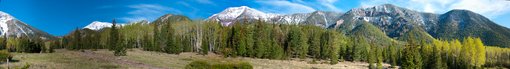
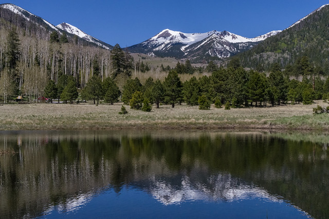
The Flagstaff Ranger District encompasses nearly 850,000 acres of National Forest lands around the Flagstaff area, from Mormon Lake and Anderson Mesa to north of the San Francisco Peaks. At 12,643 feet, the San Francisco Peaks is not only the dominant feature of the forest area we call the Volcanic Highlands, it's also the highest mountain in Arizona. Three of the summits that ring this dormant volcano's now quiet inner caldera are higher than any other mountain in the state.
This mountain is sacred to the native peoples that live in the area and its soaring profile set against a blue Arizona sky serves as a source of awe to contemporary residents and visitors. Views from the summit of the San Francisco Peaks stretch to the Grand Canyon's North Rim over eighty miles away. Hiking, sightseeing, wildlife watching and skiing are the predominant recreation activities enjoyed in this land of mountains, forests and lava flows.
Flagstaff Ranger District, extends from north of the Peaks to the south. This rolling highland is a land of ponderosa pine forests and pinyon/juniper woodlands clustered around broad prairies and small lakes. Arizona's largest natural lake, Mormon Lake, is located here. The area is also known for its plentiful wildlife. Large herds of elk roam the forests and edgelands. Bald eagles and ospreys live and hunt around the lakes. Pronghorn antelope graze the prairies.
Principal recreation activities among the lakes and prairies are boating, fishing, camping, and wildlife watching. The area also boasts some excellent cross-country skiing in good snow years.
Recreation Activities for the Flagstaff District:
- Campgrounds
- Trails
- Wilderness Areas, Boating/Fishing Sites, Scenic Drives
- Picnic Areas, Archaeology Sites, Cabin Rentals and Winter Activities
More Information
Mogollon Rim Ranger District Facility
The Mogollon Rim is a rugged escarpment that forms the southern limit of the Colorado Plateau. It extends across the entire forest and provides excellent views within Plateau Country and Desert Canyon Country as well. Dropping as much as 2,000 feet in some areas, the Rim provides some of the most far-reaching scenery in Arizona. Views stretch from its rocky precipice to Four Peaks of the Mazatzals northeast of Phoenix.
Needless to say, sightseeing is a favorite activity along the Rim, but this forest area also boasts a historic system of hiking and horseback trails, a couple of picturesque lakes for boating and fishing, and backcountry skiing for wilderness adventurers. The Mogollon Rim is home to Camp Colley, an outdoor adventure camp at Little Moqui, run by the City of Phoenix, Parks and Recreation.
The photo above (see larger view) was taken by Mark Hickcox, Civil Engineer Tech on the Mogollon Rim District, from the Hutch Mountain Lookout Tower in the summer of 2011. It is looking south-east toward Long Lake.
Recreation activities for the Mogollon Rim District:
More information
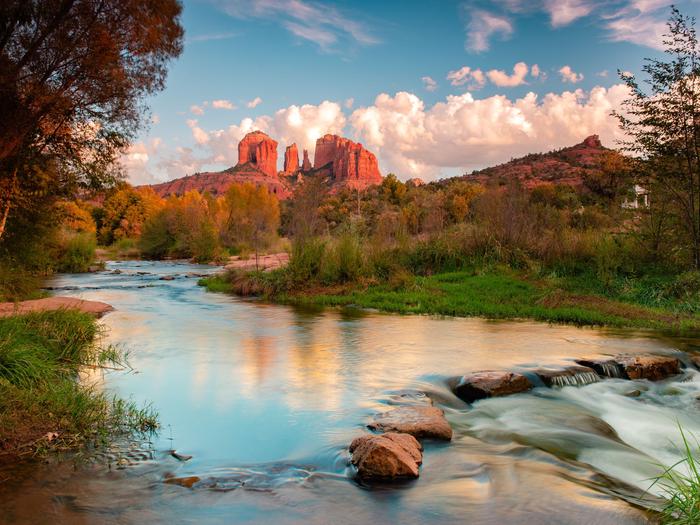
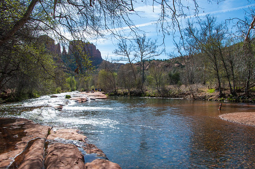
Red Rock Ranger District Facility
The colorful collection of buttes, pinnacles, mesas and canyons surrounding Sedona is famous the world around for its red rock vistas. Over the years, this area has served as the setting of many western novels and movies and has been the subject of uncounted paintings, photographs and other works of art. The remains of ancient wetlands, these crimson cliffs have been carved by the forces of the desert into one of nature's most magnificent masterpieces.
No matter what you do in Red Rock Country, you're always sightseeing. Ways to get even closer to all this scenery include: hiking, horseback riding, taking a scenic drive, sliding down a natural waterslide, picnicking, camping, taking lots of photos and fishing in Oak Creek. The Red Rock District includes some 160,000 acres of magnificent splendor. Some areas require a pass to park, so be sure to check out the information about our Red Rock Pass Program.

Get the scoop on the Red Rock Ranger District!
- Recreation Guide [PDF]
- Recreation Maps
- Red Rock Pass Information and find out where to get a Red Rock Pass
- Fee-free Days
- Road Status
- Forest Orders
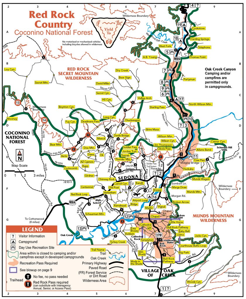
Recreation activities for the Red Rock Ranger District shown in tables:
- Campgrounds
- Trails (A-J)
- Trails (K-Z)
- Wilderness Areas, Boating/Fishing Sites, Scenic Drives
- Picnic Areas, Archaeology Sites, Cabin Rentals and Additional Information
C.C. Cragin (Blue Ridge) Reservoir Facility
NOTE!! The boat ramp at the reservoir is currently closed to trailers, as low water levels have exposed boulders and large rocks that make it unsafe and impossible for a trailer to be backed down the boat ramp. People may still access the water and carry kayaks and canoes to the water edge, but trailers with boats are not yet able to be backed down the boat ramp.
This narrow, winding body of water looks more like a canyon-bound river than a lake. Be aware that this is a canyon lake--meaning there is very little shore access around the entire reservoir. The sides of the canyon that create this reservoir are steep and there are not any sandy shores like you might expect at a traditional lake with shoreline, which makes this reservoir a destination mainly for people kayaking, canoeing, and fishing.
Fishers can catch rainbow, brown or brook trout here, stocked by the Arizona Game and Fish Department. Other types of recreation include sightseeing, wildlife watching, hiking, and mountain biking, but don't expect any wide open shores for sunbathing and swimming.
C.C. Cragin Reservoir is an important water source for the town of Payson, Arizona. Forest thinning and prescribed burning in the area under the Cragin Watershed Protection Project is helping to protect this valuable water source and improve forest health in the area. C.C. Cragin Dam was built in 1965 by Phelps Dodge, and later transferred to the Salt River Project (SRP). Learn more about the reservoir's history on SRP's history of C.C. Cragin dam and reservoir.
Elks Group Campground Campground
List of CampsitesOverview
The Elks Group Campground sits among a mix of ponderosa pines and juniper at an elevation of 6,500 feet offering a cool respite from the summer heat of the valley below. This campground facility was designed and constructed by the Winslow Elks Lodge and generously donated to the Mogollon Rim Ranger District. The campground is designed to meet the needs of large groups and can accommodate 100 people, offering picnic tables, grills, and fire pits. There are vault toilets. For every 25 people after the first 50, the group will need to provide additional port-a-pots.
Recreation
Many visitors spend time relaxing and exploring the area. The nearby C.C. Cragin Reservoir and Knoll Lake offers opportunities for water based recreation, while the Arizona National Scenic Trail, General Crook National Recreation Trail, and historic Cabin Loop Trail System offers opportunities for hikers, bicyclist, and equestrian users. There are also several Fire Lookout Towers in the area.
Facilities
The group campground is in a primitive setting on 6 acres. The site has a swing set, horseshoe pit, poles for a volleyball net, flag pole, pavillion, grills, picnic tables, a large fire ring, a 500 gallon water buffalo, trash collection and vault toilets. It is important to know that for every 25 people after the first 50, the group will need to provide additional port-a-pots. The site can accomodate up to 100 people and 50 vehicles.
Natural Features
The campground is in a transition zone where ponderosa pines fade into stands of pinyon and juniper trees. The nearby Mogollon Rim is one of the most striking geologic features in the state. This steep escarpment, measured in thousands of feet, stretches from New Mexico diagonally across two thirds of Arizona and offers sweeping views of the landscape.
Nearby Attractions
The community of Happy Jack, Arizona offers two convenience stores, two restaurants, and a gas station.
Jack's Canyon Camping and Climbing Area Facility
![[photo] Jack's Canyon view from above and at the creek.](http://www.fs.usda.gov/Internet/FSE_MEDIA/stelprdb5305682.jpg)
Situated in a beautiful canyon where water has carved the rock, Jack’s Canyon offers vertical to wildly overhanging routes on compact stone. The majority of the climbing is characterized by steep highly pocketed limestone/sandstone mix cliffs. Route length varies from short “bouldery” twenty foot routes to long “pumpy” routes around seventy feet. On vertical walls, the rock can be bubbly with edges and blocks. If you want to find fun and safe sport climbing on the Coconino National Forest, this is your place. Sport climbing, focused on movement and safety offers the opportunity for large dynamic moves on well protected routes. Fixed anchoring systems here keep climbers safe while minimizing impact to the rock compared to traditional anchoring systems such as pitons and trees. Jacks Canyon boasts 300 routes of what some consider being some of the best sport climbing in the country. Jacks Canyon is a great collaboration between the National Forest and the rapidly growing user group of rock climbers.
The roll-over photos here are from the top of the rim overlooking climbing areas and at the bottom at the creek.
Camping: The camping is free and unimproved at the canyon rim, where a 10 minute trail gets you to the routes. Please camp at obvious sites.
Weather: The Weather is great year round with spring and fall offering the best conditions. In the summer you’ll be chasing the shade with temperatures rising to the 90’s F. During the winter, temperatures can get down to freezing and can be snowy, but the sun warms the rock. Chase the sun and you’ll be climbing in tee-shirt and shorts. Watch out for late spring and summer monsoon floods.
Attractions: Climbing, Hiking, Wildlife viewing
Facilities: Toilet (vault type), NO water or trash services (Pack-it-In, Pack-it-Out)
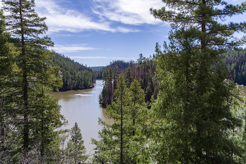
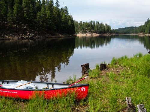
Knoll Lake Facility
![[photo] Knoll Lake - Click for Larger view](http://www.fs.usda.gov/Internet/FSE_MEDIA/stelprdb5301075.jpg)
This secluded forest lake attracts visitors for a number of reasons. Surrounded by ponderosa pines, with a picturesque island in its middle, Knoll Lake provides a scenic setting in which to enjoy your canoe or other small boat. Fishing is good here too, offering rainbow, brown and brook trout.
If the fish aren't biting, you'll definitely want to take a tour of the nearby Mogollon Rim. This two thousand foot escarpment marks the southern edge of the Colorado Plateau and drops from cool highlands to low deserts in a picturesque, stomach wrenching plunge.
The lake covers approximately 75 acres and is about 50 feet deep.
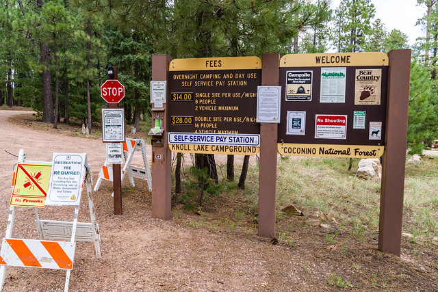
Knoll Lake Campground Campground
List of CampsitesThis secluded forest camp offers easy access to two features of high visitor interest.
The first is Knoll Lake, a medium-sized body of water tucked away in a picturesque setting. People come here to fish for trout and tour the lake in small boats.
The second feature of interest near this campground is the spectacular Mogollon Rim, a two thousand foot escarpment that marks the southern edge of the Colorado Plateau. This picturesque plunge from cool highlands to low deserts extends across most of Arizona. The area around Knoll Lake, however, is the home of some of the Rim's most magnificent views. It provides a scenic setting for hiking, mountain biking, horseback riding or just sitting back and enjoying the panorama.
Group Campouts and Events: This campground does not have facilities for large groups or group activities. If one campsite cannot accommodate your group (eight at a single site, 16 at a double site), please call the Mogollon Rim Ranger District at 928-477-2255 to plan your group camp-out at Elks, Moqui, or Long Valley group campgrounds.
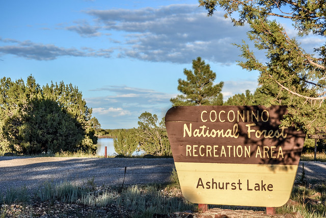
Ashurst Lake Campgrounds Campground
List of CampsitesAshurst Lake/Forked Pine Campgrounds
Good fishing and excellent views of the San Francisco Peaks characterize these two lakeside campgrounds. Ashurst Lake is stocked with trout, bass, and channel catfish, and boasts enough wind for windsurfing.
Both campgrounds hug the lakeshore with campsites huddled in a picturesque stand of gnarly old juniper trees and pinyon pines. One of Ashurst Lake's most notable characteristics is it ability to hold a high water level in drought years. That can be very important here in northern Arizona where less resilient lakes sometimes dry up.
In addition to fishing and board sailing, the lake offers excellent opportunities for birdwatching during the spring waterfowl migration. For a special treat look for white-faced ibises grazing in the shallows along with the cinnamon teal, pintails and other ducks. Bald eagles and osprey can also be seen in the area, along with a number of species of hawks and songbirds.
A graveled road to the lake and graveled road that surrounds most of the lake provides convenient access for most passenger vehicles and bicycles. Rustic gravel and “two-track” roads in the area offer some great opportunities to mountain bike or walk out into the surrounding juniper/ponderosa mixed forest for some wildlife viewing and open spaces. The San Francisco Peaks stand majestically on the horizon providing a grand display of Arizona’s volcanic past.
Forked Pine Campground Campground
List of CampsitesSee Ashurst Lake Campgrounds for details.
Lower Lake Mary Picnic Area Facility
This picnic area is conveniently close to Flagstaff and offers access to a number of different areas where you can enjoy your favorite outdoor recreation. When Lower Lake Mary has water in it, it's a popular place to fish for catfish and trout, depending on which has been stocked most recently. When it's dry, it's a good place to fly a kite. Lake Mary Road has wide paved shoulders and makes an excellent place to bike, roller blade or jog. Not too far away you'll find the Sandy's Canyon Trail which leads into an area of picturesque small canyons, big trees, and even bigger views. All this activity has been known to cause forest visitors to work up quite an appetite, hence the need for a picnic area.
See Lake Mary Recreation Corridor for more recreation sites and information about the area.
Mormon Lake Facility
Mormon Lake is the largest natural lake in Arizona... sometimes. During droughts it's frequently not so large, and not so much a lake. Occasionally it's even bone dry.
Wet or not, this has an excellent overlook where you can often see wildlife and birds across the lake's landscape. There is also a picturesque little resort on the lake's western shore where you can rent recreational equipment such as mountain bikes, horses to ride, snowmobiles and cross-country skis in season. Or you can drop in at the Mormon Lake Lodge, a famous cowboy steak house where the brands of local ranches are burned into the log walls.
Dairy Springs Campground and Double Springs Campground are located nearby. There, in addition to developed campsites, you'll find some excellent hiking trails which lead to panoramic overlooks of the lake and the surrounding area.
Lake Mary Narrows Boat Launch and Picnic Area Facility
There are a number of reasons to have a picnic at Lake Mary Narrows. You might be interested in fishing for the walleye, trout, and channel catfish that live in Upper Lake Mary while enjoying your picnic at the nearby picnic tables. It can also serve as a great place to take a time out from cruising in your boat, which may be anything from a canoe to a jet boat on this upland lake where there is no restriction on boat motor size. On the other hand, if you're a bird watcher, you may want to come here to see the migrating waterfowl or wintering eagles that regularly put in an appearance at the lake. In any of these cases and more, you'll find an afternoon at Lake Mary Narrows a varied and enjoyable experience.
In addition to the boat launch and parking, you can expect clean vault toilets, picnic tables and cooking grills.
See Lake Mary Recreation Corridor for more recreation sites and information about the area.
Abineau-Bear Jaw Loop Facility
From the Abineau (#127) and Bear Jaw (#26) trails, on the north slope of the San Francisco Peaks, you can see the Grand Canyon seventy miles away. These two trails make a scenic loop through forested canyons. Both end at the Waterline Road (FR 146) along the base of a long talus slope topped by Humphreys Peak, Arizona's highest point. The climb along either two-mile trail is steep and steady through stands of mixed conifer and aspen. The road completes the loop by connecting the top of one trail to the other, ascending 600' over two miles from the top of Bear Jaw Trail to the top of Abineau Trail. From this high perspective the Grand Canyon cuts a wide gap in a the plateau stretching from the mountain to the horizon. With the almost half-mile connector trail from the trailhead to the loop (where Bear Jaw and Abineau split to follow different routes up the mountain), the entire hike is approximately 7 miles long.
This route passes through an area colorful at all seasons of the year. In late spring, alpine wildflowers such as lupine, rocky mountain iris, penstemon and paintbrush splash the trailside meadows. Sunflowers add yellow in summer, and groves of aspen paint the slopes with crimson and gold during the fall.
You may spot a black bear here—perhaps the best chance you'll have around the Peaks. These big shy animals occasionally show themselves along these trails. Mule deer and elk are also plentiful. Common birds include juncos, Steller's jays and Clark's nutcrackers. In spring and early summer the melodious hermit thrush will serenade you.
Early in 2005, a huge avalanche did extensive damage to the trail in Abineau Canyon. Although the trail reopened by that summer, evidence of the avalanche still remains in toppled trees and gouged rock.
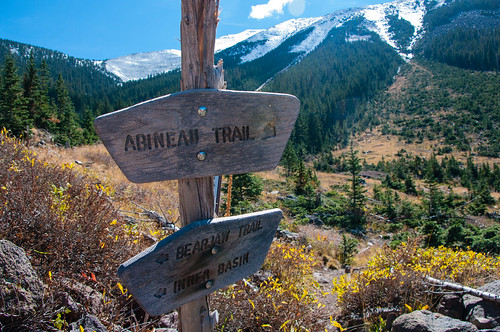
Download a slideshow about the Abineau-Bear Jaw Loop (PDF)
Kachina Peaks Wilderness Facility
View of the San Francisco Peaks from the interior of extinct volcano's crater, the Inner Basin.
Here's a wilderness experience that takes you as high as you can get in Arizona. This 18,960 acre roadless area encompasses most of the upper reaches of the San Francisco Peaks including Humphreys Peak, Arizona's highest point at 12,643 feet. The area is named for the Hopi dieties, or Kachinas, whom that culture's mythology tells us live here for part of every year. In mid-summer these dieties fly from the top of the peaks to the Hopi mesas as clouds bringing the nourishing rains of the seasonal monsoons.
Not surprisingly, this most prominent feature on the northern Arizona landscape is sacred to all of the area's indigenous people and has become a source of awe and wonder to its more recently arrived visitors and residents as well.
A number of trails offer access to this mountain which is a dormant volcano that last erupted roughly two million years ago. Some of those trails lead to the top of the several peaks which form the rim of the mountain's inner basin, a huge caldera which was formed during the mountain's most recent volcanic cataclysm. That once inhospitable crater now supports a thriving stand of white barked aspens and hardy mixed conifers. Other routes offer access to the forests and meadows which carpet the mountain's lower slopes. Views from any of these trails are well worth the effort of a visit.

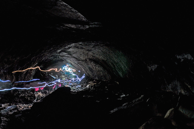
Lava River Cave Facility
This mile-long lava tube cave was formed roughly 700,000 years ago by molten rock that erupted from a volcanic vent in nearby Hart Prairie. The top, sides and bottom of the flow cooled and solidified first, after which the insides of the lava river continued to flow emptying out the present cave.
Ample evidence of how the tube was born is written in the rocks of which it is formed. Small wave-like undulations in the floor are the remains of ripples frozen in the last trickle of molten rock that flowed from the cave. Stone icicles hanging from the ceiling show where a final blast of volcanic heat caused the rock to partially re-liquefy and drip.
Dress appropriately when you come to visit, with warm clothes and sturdy shoes. The cave is as cool as 42° even in summer, and you may even find some ice inside. The rocks are always sharp and slippery, too. Bring two or three sources of light, in case one happens to fail, it can be very dark one mile from the nearest light source.
Portions of the cave which were once defaced by graffiti have been cleaned up. Today's more environmentally aware visitors take better care of such a unique resource and report vandals when they see them.
Learn more: Lava River Cave: A Natural Museum
Lockett Meadow Campground Campground
List of CampsitesThis primitive campground offers a scenic view of the San Francisco Peaks and dry camping in the cool aspen trees that surround Lockett Meadow. This is a terrific campground for those who cherish a real mountain camping experience and love to hike wilderness trails. You may catch a glimpse of the natural residents, porcupine or elk or thrill to the song of a hermit thrush that sings his best here. Even black bear have been known to stroll right through groups of picnickers without as much as a glance at their lunches.
The San Francisco Peaks are actually the remains of an extinct volcano, which mllions of years ago shattered and reshaped these great peaks, forming four of the highest individual peaks in Arizona and is home to the only region of tundra in Arizona. Inside the now quiet caldera a lush alpine environment has blurred evidence of that cataclysmic event.
The Inner Basin Trail that leads into the heart of the ancient volcano begins in beautiful Lockett Meadow. Starting at this island of emerald, which is ringed with quaking aspen stands and majestic high peaks, it leads into the mountain’s now quiet Inner Basin. The spring and summer wild flowers add a sprinkling of blue, red and yellow to the peaceful scene. While fall turns the extensive stands of aspen, which cover the steep slopes of the caldera, to solid gold, Winter avalanche tracks streak down the talus slopes exposing remnants of old lava flows which bear witness to the mountain’s turbulent heritage.
Wing Mountain Snowplay Area Facility

See the Winter Recreation page for a recreation map, backcountry permit information, and more info!
Flagstaff Winter Recreation Hotline
1-844-256-SNOW (7669)
Courtesy Flagstaff CVB
Bell Rock Pathway / Vista Facility
The Bell Rock Pathway is a 3.6 mile trail. Along this pathway you'll enjoy fantastic views of Bell Rock, Courthouse Butte, and other landmarks. Most of the pathway has a wide, hard surface, but there are some steep hills too. Some places around Bell Rock are rocky and rough.
There is a popular observation area on the west side of Bell Rock not accessible from the highway.
Bootlegger Picnic Area Facility
At this creekside picnic area you'll have a fishing hole and that's not all. Add spectacular scenery, clear water swimming holes, picturesque hiking trails and excellent wildlife watching (in other words, the standard amenities of Oak Creek Canyon) and it should come as no surprise that these pieces of recreational real estate are in high demand.
The decor at this day-use site is Arizona ash and box elders, gravel beaches and stream-bed boulders. The creek is regularly stocked with trout. Colorful songbirds add a flash of brilliance to the trees.
The A.B.Young Trail leaves from the southernmost end of the grounds. Take steps down to the creek, cross the creek and find an old metal sign indicating the trailhead.
Attractions: Picnia area, fishing, swimming/wading, hiking, sightseeing, wildlife viewing, photography.
Call of the Canyon Picnic Site Facility
This picturesque day use site in Oak Creek Canyon is at the trailhead of the West Fork of Oak Creek Trail. The trail follows the West Fork stream into a side canyon of Oak Creek Canyon, rich with maples and breathtaking beauty. Bring a picnic, your camera, and go for a hike!
For more information, see West Fork of Oak Creek Trail #108.
Clear Creek Day Use Picnic Site Facility
This is a day use site with a toilet. No overnight camping.
Crescent Moon Picnic Site Facility
One of the most photographed scenes in the southwest is towering Cathedral Rock reflected in the waters of Oak Creek at Red Rock Crossing. It should come as no surprise, then, that the picnic area located at that same site is as popular as it is beautiful. People come here to fish, swim, and wade in the creek, as well as to picnic and photograph the scenery. At times it can become quite crowded. If you want the world-class beauty of Red Rock Crossing all to yourself (or nearly so) visit early in the morning or on a weekday.
Attractions: Picnicking, waterplay, wildlife watching, photography, and fishing.
Oak Creek Visitor Center Facility
This popular visitor center at Indian Gardens offers the first public roadside rest rooms in the canyon. They were completed at Indian Gardens by the collective efforts of members of the Oak Creek Canyon Task Force in conjunction with Coconino National Forest.
The visitor center is managed under contract with Coconino Forest by Recreation Resource Management. They offer most types of hunting and fishing licenses, Red Rock Passes, and Forest Service Information. They sell maps, hiking books and interpretive souvenirs.
For more information, contact the Oak Creek Visitor Center at 928-203-0624.
The center is open daily from 8 a.m. to 4:30 p.m. starting March 30, 2012 through November.
Stoneman Lake Facility
There is still some debate over whether Stoneman Lake is the remains of a volcanic crater or whether it fills a deep, collapsed sinkhole. The location of this naturally occurring body of water at the bottom of a large bowl-shaped valley and its nearly circular shape actually support both conclusions. The fact that faults in underlying rock layers provide the only way for water to leave the lake, adds weight to the sinkhole conclusion.
The lake's recreational value, on the other hand, is something that is easily agreed upon. This medium-sized body of water, surrounded by Gambel oak and ponderosa pine covered basalt slopes is an excellent place to bird watch during the yearly waterfowl migrations, or all summer long for songbirds.
There is a gravel parking lot and boat ramp at a day use area on the lake's northern shore. Picnic tables at shaded sites nearby provide a good place to spend an afternoon.
Campground Season: There are no campgrounds at Stoneman Lake. Camping is available to the north at Mormon Lake and to the south at Beaver Creek. Please view "Dispersed Camping Guidlines" for camping in the area.
Attractions: Boating (single electric motors only), Picnicking, Wildlife viewing, Photography
Facilities: Gravel boat ramp and parking area, Picnic tables, Vault toilets
Notes:
- No camping is permitted at the day-use area. Boats may be powered with no more than a single electric motor.
- The last 4 miles of road into the lake are not suitable for passenger cars in wet weather.
- There are a number of private cottages near the lake. Please respect their privacy.
West Fork of Oak Creek No. 108 Facility
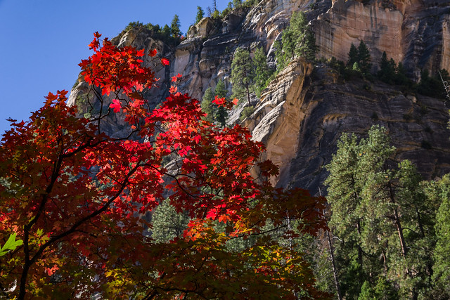
There are a number of reasons why West Fork is one of the most popular trails on the Coconino National Forest. Once you've strolled beside the pleasant little stream that ripples along the canyon floor and looked up, way up, at the dizzying cliffs that tower above it, you will fall in love with it, too. West Fork is fantastic throughout the year. In springtime, migrating songbirds decorate the trees with flashes of brilliance. In autumn, the canyon is ablaze with color, with red and gold leaves floating in clear reflecting pools under a canopy of solid color. In wintertime, icicles decorate from red rock overhangs, and snatches of snow persist in cool shadows. As a matter of fact, you'll probably find a new reason to be here every time you visit.
As for the trail itself, it's an easy stroll, but you do have to cross the stream in a number of places. Usually, that involves negotiating a few strategically placed stepping stones or taking a couple of steps in shallow water. The trail is marked and maintained for the first three miles.
Many hikers explore beyond the end of the maintained trail. Eventually the pathway ends, the route becomes more strenuous, and you will be forced to hike in the stream bed as you continue into the Red Rock-Secret Mountain Wilderness. If you choose to travel the entire 14 mile stretch from one end of the canyon to the other, plan to do a lot of wading and boulder hopping, and even some swimming. Please read this notice describing the strenuous 14 mile long full canyon route between SR 89A to FR 231 (Woody Mountain Road) before attempting this rugged wilderness route.
No matter how long a hike you take here, you'll enjoy it best if you come at a time when the trail is least crowded. Mornings and weekdays are best, better yet if they're in the off-season.
When you do come, remember to take special care and leave this beautiful place better than you found it. Of course you know not to litter, but picking flowers and autumn leaves can cause just as unsightly a scar. So can short-cutting or rock throwing. Treat this natural treasure with the care it deserves and you'll have plenty of reason to come back and see it again and again.
White Bridge Picnic Site Facility
White Bridge Picnic Site is a developed picnic area with toilets and picnic tables. Access to the Verde River and non-motorized boating, fishing and nature viewing are just some of the activities you will enjoy here. Overnight camping is not permitted at this site.
Facilities include:
- 4 picnic tables with pedestal grills
- 1 large ramada
- No drinking water
- Vault toilet
- No garbage service: Pack it out!
Double Springs Campground
List of CampsitesOverview
Double Springs Campground is an “old fashion” campground, originally built in the 1930’s, and has sites nestled in a beautiful draw filled with cool grass, ponderosa pine and Gambel oak.
Facilities
15 single-unit sites by reservations only.
Natural Features
Relax and take in the nostalgia of this historic campground or hike the Lake View Trail (2 miles one way), which originates at here. This trail leads to overlooks providing view of nearby Mormon Lake and the surrounding forests and volcanoes. Campground roads and parking spurs are gravel.
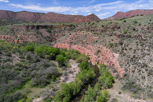
Verde River Facility
![[photo] Verde River from Beasley Flats side on the Prescott NF](http://www.fs.usda.gov/Internet/FSE_MEDIA/stelprdb5261138.jpg) The Verde River is one of Arizona's only two Wild and Scenic Rivers, yet it remains relatively undiscovered as a recreational resource. That doesn't mean this clear desert stream has little to offer. It's an excellent place to fish for a number of species including trout, which the Arizona Game and Fish Department has begun stocking on a put and take basis. The Verde is also becoming more and more popular for recreational boating. Some stretches provide scenic canoeing among long pools and manageable riffles. Other sections become exciting whitewater runs during the spring snowmelt or after late summer thunderstorms.
The Verde River is one of Arizona's only two Wild and Scenic Rivers, yet it remains relatively undiscovered as a recreational resource. That doesn't mean this clear desert stream has little to offer. It's an excellent place to fish for a number of species including trout, which the Arizona Game and Fish Department has begun stocking on a put and take basis. The Verde is also becoming more and more popular for recreational boating. Some stretches provide scenic canoeing among long pools and manageable riffles. Other sections become exciting whitewater runs during the spring snowmelt or after late summer thunderstorms.
- Overview/Background: Additional Verde River resources
- Permits & Regulations Online regulations, map, Forest Order for the Verde River
There are several recreation sites and ways to access and enjoy the Verde River:
- White Bridge Picnic Area
- Childs Dispersed Camping Area
- Sycamore Canyon Road (Google Maps)
- Find more Verde River recreation sites on the Prescott National Forest
Lake Mary Recreation Corridor Facility
The lakes are open year-round. In the warmer months (early May through early October), a fee is required to use the day-use areas, which are managed by a concessionaire. Vist individual sites for details and photos. Upper Lake Mary is the largest of Flagstaff's twin lakes. This long, narrow reservoir is especially popular with power boaters and water skiers because there is no motor size limit on it. It's also popular with those who prefer people-power or windpower over horsepower. For those who like fishing, the lake has northern pike, channel cat, crappie, and some trout. Lower Lake Mary is the smaller of Flagstaff's twin lakes. It has a tendency to disappear during the long dry spells that periodically hit this area. When the lake has water, its banks are usually lined with anglers trying to catch the trout which the Arizona Game and Fish Department stocks here. If it stays full for a year or two, it will pick up a population of northern pike and catfish. There are several other lakes nearby, including Marshall, Ashurst, and Mormon lakes. Picnic Areas
Campgrounds
Trails
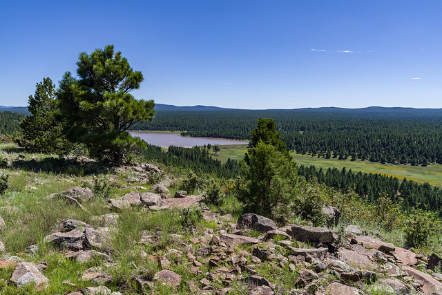
Schultz Tank Facility
Schultz Tank is a man-made pond nestled between the San Francisco Peaks and Dry Lake Hills at Schultz Pass. Two earthen dams create a pair of reservoirs along the drainage. The smaller upper tank is often dry. The larger lower tank may vary throughout the season, filling to overflowing after heavy winters, and rarely completely empty in dry years.
The tank is a haven for wildlife. A few ducks will live on the pond through the summer months. Small birds can usually be seen cavorting over the pond chasing flying insects. On quiet days, elk and deer may appear in the twilight hours. To ensure wildlife have access to water, state law prohibits camping within a quarter mile of a wildlife tank. Schultz Tank is day use only. Camping is prohibited here.
The views of the San Francisco Peaks here are fantastic. The only amenity here is a toilet at the parking lot. If you come for a picnic, make sure to bring a picnic blanket and drinking water.
Several trails can be accessed from the Schultz Tank Trailhead, which is just a half mile east of the Sunset Trailhead:
- Weatherford #102
- Arizona Trail Passage 34 (a short hike up Weatherford)
- Kachina #150 (approximately a mile up Weatherford)
- Little Elden #69
- Sunset #23 (the trail can be accessed by following the paths around the far side of the tank)
- Schultz Creek #152 (west on Sunset, and a short hike to Sunset Trailhead)
West Clear Creek Facility
The deep, rocky canyon cut by West Clear Creek, as it slices its way free of the Mogollon rim, is home to West Clear Creek Wilderness, one of the most unique Wilderness Areas in the Southwest. This gorge is so narrow that in places the stream fills it from wall to wall. To descend one has to swim or wade, not once but as many as 15 or 20 times. Lower reaches of the canyon are more accessible and provide excellent places for secluded recreation such as swimming, hiking, trout fishing, and wildlife watching. In addition to the many colorful birds in this area, it is home to some interesting larger creatures such as black bear, javelina, and mountain lion.
Campground Season: All year at Clear Creek Campground near Highway 260. Clear Creek Campground is open year-round.
Attractions: Fishing, camping, waterplay, sightseeing, wildlife viewing, photography
Facilities:
- Clear Creek Campground has drinking water, cooking grills, vault toilets, a group site, and the General Crook National Recreation Trail nearby.
- Bullpen Day Use Area has vault toilets and access to the nearby Blodgett Basin Trail and West Clear Creek Trail. There are no other amenities at the Bullpen area. There is no camping (dispersed or campground) at Bullpen.
Munds Mountain Wilderness Facility
You can get to know Red Rock Country from top to bottom in the Munds Mountain Wilderness. This 18,150 acre area stretches from the tops of Munds and Lee mountains to the bottoms of Jacks, Woods, and Rattlesnake canyons. In the high country, you'll enjoy views that stretch all the way from the floor of colorful Oak Creek Canyon to the top of the San Francisco Peaks, Arizona's highest mountain. From the trails that traverse canyon floors, you'll get an entirely different perspective on this area's red rock magnificence, looking up at crimson canyon walls set against a deep blue Arizona sky.
The area is very convenient to the villages of Sedona and Oak Creek, extending right up to the edge of their posh resorts and galleries. Within this bit of suburban wilderness you'll find two of the area's most famous and most picturesque landmarks, Courthouse Butte and Bell Rock. Many people believe there is spiritual energy in these rocks, concentrated in centers they call vortexes. Whether you follow this spiritual belief or not, you'll be one of a very few if you don't experience your own energizing bliss among these picturesque formations.
A number of trails offer access to the wilderness. Two you may want to try are Jacks Canyon Trail and the Hot Loop Trail. Both lead from canyon bottom to high overlook. Quite likely you'll have them to yourself, just you, the jackrabbits and the rest of the wildlife, that is.
Trails in Munds Mountain Wilderness
The following trails and areas are partially or completely inside the Wilderness.
- Jacks Canyon #55
- Hot Loop #94
- Woods Canyon #93
- Schnebly Hill #158
- Munds Mountain #177
- Margs Draw #163
- Bell Rock
- Courthouse Butte Loop
Wet Beaver Creek Facility
This clear, cool brook remains pleasantly secluded in the deep red rock canyon it has cut into the southern rim of the Colorado Plateau. For much of its length, the land bordering Wet Beaver Creek has been declared a Wilderness Area, the Wet Beaver Wilderness. In addition to the opportunities for solitude such an area offers, the stream's pools and riffles are a popular place to fish, hike, swim, and bird watch. The waters of the stream are stocked with trout. The lush riparian area beside its banks is alive with a full palette of songbirds. The desert beyond that oasis bristles with the highly adapted plants of the upper Sonoran Desert.
West Clear Creek Wilderness Facility

The West Clear Creek Wilderness, established in 1984, is a narrow but lengthy wilderness that follows the contours of West Clear Creek from its western terminus at Bull Pen Ranch to the headwaters of Willow Creek and Clover Creek to the north and east. The persistent strength of these waters have cut at the walls of the Mogollon Rim of the Colorado Plateau, creating the deep, narrow, rugged and spectacular canyon we see today. Due to the stark variance in elevation and sunlight across canyon walls, the West Clear Creek Wilderness offers a wide range of vegetation, geology, recreational opportunities, and supports a variety of wildlife.
Visitors should note that when traversing the canyon, stream crossings are unavoidable. The West Clear Creek Trail (the longest and most-used trail within the wilderness) has four crossings that range from knee-height to impassable depending on time of year, weather, and flooding. Those looking to follow the creek beyond the maintain trail should prepare for more than a dozen pools, which sits between both canyon wall sides and can be up to a quarter mile long, requiring wading or swimming.
Naturally, a place this remote and inaccessible provides superior opportunities for solitude and primitive recreation. For most of its length the stream is a valuable fishing resource and is stocked with trout by the Arizona Game and Fish Department. Trails leading into the canyon from the rim attract hardy adventurers seeking good fishing and secluded swimming holes. Trails that lead up from the canyon mouth get a lot of use by weekend anglers, picnickers, day hikers, and backpackers who use the primitive trailhead at the old Bull Pen Ranch.
Read more about West Clear Creek Wilderness.
The western portion of West Clear Creek is managed by the Red Rock Ranger District (928-203-2900). The eastern portion is managed by the Mogollon Rim Ranger District (928-477-2255). The District boundary runs north-south through the Home Take Draw area.
Wilderness areas are rare, wild places set aside by Congress where the land is allowed to retain its natural state, serving as a natural haven for humans to escape modern civilization and for nature to be itself. To help minimize human impacts in wilderness and maintain its character, several laws and regulations have been put in place and we ask that visitors practice "Leave No Trace ethics."
The image above was taken overlooking the canyon just west of state Route 87. This little slice of heaven is on the eastern end of West Clear Creek Wilderness.
Red Rock-Secret Mountain Wilderness Facility
This collection of cliffs, buttes, and canyons has to rank as one of nature's most magnificent masterpieces. It certainly is one of the most colorful. Red is the predominant hue here among these 43,950 acres of wind and water sculpted pinnacles, windows, arches, and slot canyons. The area is criss-crossed with trails that take you everywhere from the deepest gorges to the most prominent panoramas. Along these pleasant paths you'll discover wonders made both by nature and by some of the area's earliest human inhabitants. Watch the canyon walls and high cliffs for rock art and abandoned dwellings as diligently you keep an eye to the horizons for vistas and breathtaking overlooks.
As you part the chaparral to emerge into a hidden grotto or clamber up a slick rock slope to a dizzying precipice, you may even experience the unmatched thrill that you could have been the first to see whatever you've stumbled upon. One thing you'll surely rediscover here among the manzanita and red rocks is your own sense of wonder.
Trails in the Wilderness
All trails into the Wilderness start in the Red Rock Ranger District except Secret Mountain Trail #109, which is accessed from the Flagstaff Ranger District.
- A.B. Young #100
- Bear Mountain #54
- Bear Sign #59
- Boynton Canyon #47
- Brin's Mesa #119
- David Miller (see Secret Canyon Loop Trails)
- Dry Creek #52
- Fay Canyon #53
- HS #50
- Loy Canyon #5
- Long Canyon #122
- Mooney #12
- Secret Canyon #121
- Secret Mountain #109 (Flagstaff Ranger District)
- Soldier Pass #66
- Sterling Pass #46
- Vultee Arch #22
- West Fork Trail #108
- Wilson Mountain #10 and North Wilson #123
Additional Source: The Wilderness Institute.
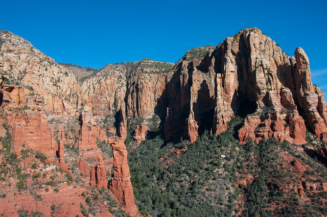
Desert Canyon Loop Scenic Drive Facility
This is a drive through scenic desert country where you'll see colorful canyons, lush oases, picturesque ranches, and out of the way Indian ruins. The route skirts the lower elevations of Arizona's rim country where red rock canyons spill out from under thick basalt flows. The road cuts two of these canyons and offers access to a third along the way.
Roadside signs point the way to a number of hiking trails and a few spur roads leading off into the backcountry.
There is a picnic area at Wet Beaver Creek Crossing (Beaver Creek Day Use Area) and another along West Clear Creek (Clear Creek Campground) at route's end. A primitive road leads to an undeveloped campground and recreation area at the mouth of West Clear Creek Canyon. A short side trip leads to Montezuma's Well National Monument, a large spring surrounded by cultural sites.
Keep an eye out for road runners, coyotes and javelinas as you drive. The road is a bit rough, but if you go slow it's not too bad.
Attractions: Sightseeing, History (ruins and ranches), Camping/picnicking, Swimming/wading, Fishing, Hiking, Mtn. biking, Wildlife watching
Road Condition: FR 618 is graveled and suitable for passenger cars; however, it can become soft and slippery when wet. FH 9 is paved.
Driving Time: 3.5 hours or all day
Photo (above): viewof Wet Beaver Creek from Bell Trail, one of the many sights and activities to enjoy along the Desert Canyon Loop. USFS/Deborah Lee Soltesz (2008)
Wet Beaver Wilderness Facility

The Wet Beaver Wilderness, established in 1984, encompasses much of the Wet Beaver Creek and surrounding canyons. A perennially flowing stream in a desert environment, Wet Beaver Creek offers a unique and precious habitat for wildlife and plants. Closer to the creek, cottonwoods and sycamores trees are a dominate plant. As you traverse farther up the canyon walls, those trees give way to junipers, prickly pear cacti, mesquite, and catclaw before the canyon opens up to grassy plateaus with scenic views. Travelers going into the depths of the canyon will see a number of coldwater pools stretch between canyon walls of sandstone, shale, and, in some sections, basalt. Whether you ascend the plateaus, navigate the canyon floors, or enjoy a mild hike to a favorite swimming spot or viewpoint, the Wet Beaver Wilderness has plentiful opportunities for solitude and unconfined recreation.
Wilderness areas are rare, wild places set aside by Congress where the land is allowed to retain its natural state, serving as a natural haven for humans to escape modern civilization and for nature to be itself. To help minimize human impacts in wilderness and maintain its character, several laws and regulations have been put in place and we ask that visitors practice "Leave No Trace ethics."

Most visitors spend their time in the wilderness’s lower, more accessible areas, such as the first several miles of the Bell Trail. Hiking, fishing, swimming, wildlife viewing, and running are popular forms of recreation for this area.
Trails
- Bell Trail #13: the only developed route into Wet Beaver Creek Canyon and the wilderness area it shelters.
- Apache Maid Trail #15: starts at the mouth of Wet Beaver Creek Canyon, then splits from Bell Trail to climb the canyon's north wall.
- Wier Trail #85: contours from near the information board on the Bell Trail before dropping to creek level.
- White Mesa Trail #86: on the west side of Casner Canyon.
Day Use and Picnic Areas
Camping
- Lawrence Crossing: Small free campground next to the creek, with toilet and fire rings, located 2 miles away: FR 618 to FR 121 to FR 618G.
- Dispersed camping along Forest Road 618: Numerous locations, no facilities.
- Clear Creek Campground: Fee-based campground with all amenities, located on West Clear Creek; follow FR 618 to SR 260 to Clear Creek Campground. Approximately 13 miles from Beaver Creek Day Use Picnic Site on dirt road.
Oak Creek Facility
This clear canyon stream may be one of the most scenic fishing and swimming holes in the world. Oak Creek flows through Oak Creek Canyon, a narrow gorge it has cut along a fault line in the same rock strata that form the Grand Canyon. But this smaller cousin of the world's most prestigious chasm, is much more accessible than its more famous relative. A road leads right down the middle of it. And if you'd really like to get to know these crimson cliffs and crystal pools up close and personal, there are plenty of overlooks and picnic areas, hiking trails and creekside paths to help you do it.
In Oak Creek Canyon, be sure to stop by the Oak Creek Visitor Center at Indian Gardens when it opens for the season, or visit the Red Rock Ranger District Visitor Center near the Village of Oak Creek year-round.
There is a catch and release section along Oak Creek from Call of the Canyon downstream to Junipine Resort. Refer to Arizona Game and Fish fishing regulations for details.
Campgrounds
Campgrounds usually fill early. The best opportunities for getting a campsite are weekday mornings between 8 a.m. and 11 a.m., or make reservations where available.
Picnic Areas
- Banjo Bill
- Bootlegger
- Call of the Canyon
- Crescent Moon
- Encinoso
- Grasshopper Point
- Halfway
- Midgely Bridge
- Slide Rock State Park
Additional Information
- Coconino National Forest: Red Rock District - Forest recreation information for the Oak Creek Canyon, Sedona, and the Verde Valley areas.
- Slide Rock State Park (glass containers are prohibited)
- Red Rock State Park
- Recreation Alternatives to Oak Creek Canyon
Hunt Unit 11M (Peaks) Facility
 A primarily roadless and Wilderness hunt area designated to help restore aspen, in particular young aspen sprouts that are browsed upon by elk and deer. It’s ideal for those seeking a unique and challenging hunt on foot or horseback.
The Coconino National Forest and Arizona Game & Fish Department (AZGFD) teamed-up to create this new AZGFD sub-unit. The Peaks Hunt is Game Management Unit 11M and was first established in 2011. It has since become a popular hunt with above average success even though it is listed as a “Limited Opportunity” hunt area.
The unit includes the San Francisco Peaks and Hart Prairie – some of the most scenic areas on the forest and the highest elevation in Arizona. The 1996 Hochderffer Fire (pictured here) and 2010 Schultz Fire burn scars are also within the unit boundary.
Arizona Nordic Village in the Winter Facility
 Make your way to Arizona Nordic Village during the most magical time of the year, winter! With over 40 kilometers of trails specifically groomed for cross-country skiing and separate trails packed for snowshoeing and fat tire biking, you are sure to have an unforgettable experience. To add to your experience book an overnight stay in one of our cabins or yurts and ski yourself and your gear out with you! Front country yurts are located 100 feet from the parking lot, back country cabins and yurts range from 0.5 miles to 3 miles from the parking lot. Vehicles are prohibited on the trail systems. The winter season at Arizona Nordic Village usually begins mid-December and ends in March each year.
Visit the Arizona Nordic Village website for detailed information, lodging reservations, and event bookings. See Winter Recreation Map and Information for more about winter sports and snowplay in the Flagstaff area.
See Arizona Nordic Village in the Summer for information about hiking, group events, and other summertime activities.
Red Rock Ranger District Visitor Center Facility
The Red Rock Ranger Station has an amazing visitor center where visitors and locals alike will enjoy learning about the area’s many scenic wonders and world class recreation opportunities.
Services offered at the Red Rock Ranger District Visitor Center
- Recreation Activity/Trip Planning Assistance
- Detailed Trail/Road Information
- Free Forest Recreation Guide with map
- Arizona Natural History Association Store (Maps, Books, Gifts)
- Sale of Red Rock Passes (annual only)
- Sale of Federal Interagency (America the Beautiful) Passes
- Sale of Forest Product Permits (personal use fuelwood, rock for landscaping)
- General Forest information
Environmental Education Services and Exhibits
Here is a brief overview of the services and exhibits offered at the Red Rock Ranger District Visitor Center. For more detail, see Environmental Educational Services and Exhibits. View photos of the facility in the slideshow below or view the photo album on Flickr
Inside the visitor center building:
- Plan Your Trip Interactive recreational trip planning.
- Stories In Stone: Red Rock Country geology display.
- Honor the Past: Human timeline of the Verde Valley Area.
- The Mosaic of Life: Interactive display highlights the 7 biotic communities found in the region.
- Fire: Nature’s Housekeeper: Meet a Forest Service firefighter and learn the vital role fire plays.
Outside Displays: Native plant garden, Smokey Bear, and stunning views!
Additional Educational Opportunities: Special programs, events, and school tours.
See News and Events to get a listing of upcoming events in the Red Rock Ranger District and throughout the Forest.
Pumphouse Wash (FR 237) Dispersed Camping Area Facility
Pumphouse Wash (Forest Road 237) is a popular dispersed camping area in the ponderosa pine forest along SR 89A, midway between Flagstaff and Sedona, Arizona. The area is conveniently located near Oak Creek Canyon, Sedona, Flagstaff, Woody Mountain Road, Lake Mary, and a variety of recreation sites. It is a popular alternative to traditional campgrounds for visitors to Oak Creek Canyon and the Flagstaff area.
There are four campsite loops, each containing between 11 and 26 signed and numbered sites. The site offers excellent camping opportunities for large groups as well as families and individuals. Most sites offer partial to full shade beneath towering ponderosa pine trees, and are generally flat, making it easy to set up tents or campers. Each site has parking and a campfire ring. There is no trash service, so if you pack it in, pack it out. There are no restroom facilities. Portable toilets are highly recommended.
FR 237 and the camping loop roads are well maintained and suitable for passenger cars.
Photo tour from this site [Flickr].
Around the Peaks Loop Facility
This drive takes you all the way around Arizona's highest mountain, winding through a land of pine forests and aspen groves, open prairies and rustic homesteads. Anytime is a good time to enjoy this drive, although the roads are closed through much of the winter (you might want to ski or snowmobile it then).
In the spring, wildflowers follow the retreating snow up the mountain. They color the meadows and decorate the forests reaching a climax just as summer comes to a close. Autumn then turns the mountain to gold, filling forest roads and trails with visitors come to enjoy the colorful display.
There are a number of places along this route where you can stop to take a hike, enjoy a lunch or even set up a primitive camp. That way you can take more than one day to do this drive or combine it with one or more of the other scenic drives in the vicinity of the San Francisco Peaks.
Marshall Lake Facility
Marshall Lake is a small marshy body of water that's generally full of coots and other waterfowl splashing, flapping, and cooting around. It is such valuable wildlife habitat that it is managed in partnership by Ducks Unlimited and the Arizona Game and Fish Department.
During most years the lake has enough water in it to be stocked with trout by the Arizona Game and Fish Department. In dry years, however, it may temporarily disappear! Even when the lake is dry this area still offers excellent opportunities for outdoor recreation.
Dry or wet, a number of primitive campsites near the east side of the lake provide exceptional views of the peaks from pine sheltered locations. The surrounding area also serves as a good place to come to see some of this area's plentiful elk or its rare wintering bald eagles. The lake itself provides a hunting site for resident ospreys and a rest stop for migrating waterfowl.
Here is a 6-photo slide show. Click any image for full-size view.
Plateau Lakes Scenic Drive Facility
South of Flagstaff, a collection of large and small lakes fill natural depressions in the area's volcanic caprock. Plateau Country is popular with anglers, boaters, birdwatchers, campers, and hikers. It is also popular with photographers for the lakes serve as reflecting pools for the surrounding mountains and forests. During the appropriate seasons, birdwatchers and other wildlife enthusiasts come to take advantage of the annual waterfowl migrations and to observe rare bald eagles that spend the winter here fishing the open water of the surrounding lakes.
In the vicinity of Mormon Lake you may want to visit the picturesque little village along its western shore. This requires a short detour along FR 90 and FR 240. In the village you'll find a lodge and restaurant, along with a number of rentable cabins. You can also rent a riding horse here, or a mountain bike or even cross country skis and snowmobiles in winter.
After leaving Forest Highway 3, the Plateau Lakes Scenic Drive takes you down a little traveled country road through meadows and forests where you'll see vestiges of the area's ranching heritage and perhaps catch a glimpse of some of its plentiful wildlife. The return trip is via Interstate 17 which features an excellent long distance view of the San Francisco Peaks.
West Clear Creek Wilderness - Mogollon Rim Facility
The vast West Clear Creek Wilderness is located on both the Red Rock District and the Mogollon Rim District. Click here for the main West Clear Creek Wilderness page.
Fossil Springs Wilderness (Mogollon Rim) Facility

The vast Fossil Springs Wilderness is located on both the Red Rock District and the Mogollon Rim District. Visit the official Fossil Creek Wilderness page for full details.
This 11,550 acre Wilderness boasts what has been described as the most diverse riparian area in Arizona. Over thirty species of trees and shrubs and over a hundred species of birds have been observed in this unique habitat.
Most people come to Fossil Creek to sunbathe, wade, hike and birdwatch. It's also a great place to take photographs. The lushness of the riparian area strikes a sharp contrast to the brittle desert that surrounds it.
Wing Mountain Dispersed Camping Facility
Looking for a camping spot in the woods with easy access to some of the Flagstaff area's fantastic trails and recreation opportunities along US 180? The Wing Mountain area southwest of the San Francisco Peaks offers fantastic dispersed camping along Forest Roads (FRs) 222 and 171, suitable for tents, campers, and recreational vehicles.
Wing Mountain is a prominent cinder cone volcano located approximately six miles southwest of the San Francisco Peaks, rising to an elevation of 8,560 feet. The mountain is surrounded by ponderosa pine forest on fairly level terrain at approximately 7,600 feet.
- FR 222 and FR 171: Easy to navigate, with fairly smooth, wide dirt roads offering areas where you may pull your vehicle and rig up to 300 feet off the road (refered to as "camping corridors" on the Motor Vehicle Use Map).
- Western end of FR 222A (between FR 171 and FR 519): Easy to navigate and offers areas suitable for everything from tents to recreational vehicles.
- Northern end of FR 222A (near FR 222) and western end of FR 9001P (near FR 171): These roads are narrower and rougher, and more suited to tent or small trailer camping.
Nearby Attractions and Activities
Distances and estimated driving times from the junction of US 180 and Forest Road 222:
- Arizona Snowbowl: 8 miles, 16 minutes
- Humphreys, Aspen Loop, and Kachina trailheads (at the Snowbowl): 8 miles, 16 minutes
- Kendrick Park Watchable Wildlife Trail: 11.5 miles, 13 minutes
- Bismarck Lake Trail: 13.5 miles, 22 minutes
- Arizona Nordic Village: 7.8 miles, 10 minutes
- Red Mountain Trail: 23 miles, 27 minutes
- Slate Mountain Trail: 24 miles, 40 minutes
- Lava River Cave: 10.5 miles, 20 (via FR 245) to 30 minutes (via FR 222)
Schultz Pass Road Scenic Drive Facility
Here's a scenic drive that offers many of the same attractions as longer drives farther out of town. Shultz Pass once served as a short cut from settlements in the eastern part of the Flagstaff area to downtown. Today, it plays an important role as the quickest route to escape the hustle and bustle of the city for the peace and quiet of the national forest. This drive provides easy access to great views of the San Francisco Peaks, cool ponderosa pine forests, lots of hiking trails, picturesque picnic spots where you can spend the day or set up camp. In the fall it has a good display of colorful aspens and there is even a good chance you'll see some of the resident elk, mule deer or other animals.
You can drive it in your high-profile vehicle, pedal it on your mountain bike or even ride it on horseback. Take a picnic and spread your picnic blanket by Schultz Tank (at the Schultz Pass Trailhead), where you can often see ducks and birds playing and hunting around the water. Wander around the tank for beautiful Peaks views, or take a longer hike up Sunset Trail. Extend your tour by continuing up to Lockett Meadow before returning back to the turn-off to U.S. 89 for your return to Flagstaff.
However you choose to visit this popular area, you'll no doubt find others doing the same. Please show them the same consideration you would like to be shown in return.
Bonito Campground (AZ) Campground
List of CampsitesOverview
Bonito Campground is located 18 miles northeast of Flagstaff, near Sunset Crater/Wupatki National Monument. Elevation is 6,900 feet. Bonito Campground is named for the Bonito Lava Flow which oozed across this high desert plain some 900 years ago. That river of liquid rock, now frozen forever, is just one of the many remnants of volcanic activity which lend an otherwordly appearance to this starkly beautiful place.
Recreation
Hiking, sightseeing, wildlife viewing are popular activities.
Facilities
The campground has 44 single campsites with 1 ADA accessible site. 22 sites are reservable and 22 sites are dedicated as first-come-first-served sites. Each site has provided picnic tables, fire rings and cooking grills. The campground has paved roads and spurs, drinking water and flush toilets. Bonito campground is pet friendly. Pets must always be restrained or on a leash.
Natural Features
Beautiful tall Ponderosa pines are abundant throughout the campground and across nearby ravines and hillsides. Bonito is a restful place to simply relax and enjoy nature.
Nearby Attractions
Also nearby is Wupatki National Monument. The centerpiece of this area is a four story masterpiece of Native American stone masonry. Construction of that stone-age condominium began in about 1120 A.D. At one time it contained as many as 100 rooms and housed as many as 125 people. Both Sunset Crater and Wupatki have visitor centers and feature self-guided as well as interpreter guided. The entrance to Sunset Crater National Park is adjacent to the campground. The Visitor's Center provides much information on the geological history of the area. You can enjoy learning about the Native Americans who populated the area as you wander through the nearby Walnut Canyon National Monument. The historic downtown section in nearby Flagstaff will provide a glimpse into the early days of the city's past.
Soldier Pass Permit
Soldier Pass provides a diverse experience beginning in an urban setting and eventually leads into Red Rock Secret Mountain Wilderness, increasing the potential for solitude.
