
Prescott National Forest
Prescott National Forest: "Where the Desert Meets the Pines." Central Arizona's mild climate makes the Prescott a year-round destination to camp, fish, picnic, hike, and ride! (MORE recreation opportunities and photos...)

RecAreaDirections
Open with Google Map
Misc
| Stay Limit | |
| Reservable | false |
| Keywords | |
| Map Link | |
| Contact Phone | |
| Contact Email |
Permits info
Facilities
PLAYGROUND GROUP Campground
List of CampsitesOverview
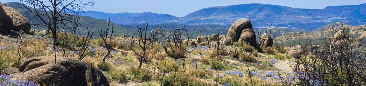
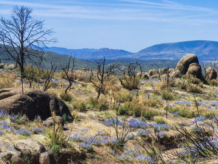
Close to historic western towns and centrally located in Arizona, Playground Group Campground is a great place for groups of up to 100 people to enjoy a secluded mountain getaway.The 7,500 ft. elevation of the site, puts it near the summit of Mingus Mountain in Prescott National Forest. Spectacular views of the surrounding desert valleys as well as the nearby towns of Sedona, Jerome and Prescott Valley await campers on the winding drive to and from the site.
Recreation
The surrounding forest offers many hiking trails of various levels of intensity, from easy short-distance walks to more challenging elevated climbs.Campers who need a break from hiking can relax around the campground, take in the views and listen to the sound of the wind in the pines.
Facilities
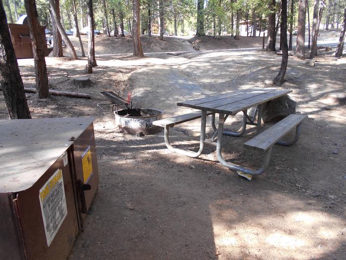
The site has a large group gathering place with picnic tables, grills, a large fire pit and vault toilet and is adjacent to a family picnic area. There is no drinking water available.The nearby towns of Prescott Valley and Cottonwood have grocery stores, restaurants, gas stations, shopping and other conveniences.
Natural Features
The campground is in a secluded site in the tall ponderosa pine trees. Pleasant daytime temperatures and cool mountain breezes make it a nice respite from the summer heat of nearby deserts.Nearby Attractions
A short drive away is the colorful town of Jerome, an abandoned mining town that has been transformed into an artist and tourist community.Tuzigoot National Monument, an ancient ruin of the Sinaguan culture, and Dead Horse Ranch State Park, which has mountain biking, canoeing and fishing along the Verde River, are also close by.
Tuzigoot National Monument
Dead Horse Ranch State Park
THUMB BUTTE Campground
List of CampsitesOverview
Thumb Butte Group Picnic Area is a convenient place for groups of up to 100 people to enjoy a day outdoors. The site is located under the towering pines of Prescott National Forest about 4 miles west of Prescott, and provides easy access to a variety of trails and amenities. It offers a year-round pavilion and a quiet, shaded setting for luncheons, church gatherings, family picnics and other large functions. To make reservations click on the availability button to the right to book this site or call 1 (877) 444-6777. For general Thumb Butte site questions contact the Bradshaw Ranger District at 1 (928) 443-8000.
Recreation
The Thumb Butte area is popular for hiking, mountain biking, rock climbing and horseback riding. Many trails can be found within a short walk or drive, including two that ascend Thumb Butte. Horseshoe pits are available at the picnic site; visitors interested in playing should bring their own horseshoes.Facilities
The picnic site is equipped with 12 picnic tables, 1 serving table, a covered picnic shelter, four charcoal grills and one campfire ring. There is designated parking (gated area) for 26 standard size vehicles. Guests have the convenience of restrooms with flush toilets and drinking water. The area is lighted after dark, and electric outlet(s) (20 amp maximum) are provided.Trash collection is limited and guests are encouraged to pack out their own trash.
Natural Features
The facility is set in a ponderosa pine forest at an elevation of 5,700 feet, at the base of the Thumb Butte rock formation and adjacent to Miller Creek. The forest is home to a wide variety of wildlife, including deer, mountain lions, bobcats, coyotes, foxes, rabbits, lizards, snakes and birds.Summer temperatures are pleasant, and winter is cool to cold with occasional snow. Afternoon thunderstorms are possible from late June through mid-September.
Nearby Attractions
Restaurants, shopping, historic sites and many amenities are nearby in the historic town of Prescott.TURNEY GULCH GROUP Campground
List of CampsitesOverview
Turney Gulch is a remote, scenic location for groups of up to 100 people to rest under the stars and towering pines of Prescott National Forest. Site accomodates 30 vehicles or less. The site lies near Horse Thief Lake and is seven miles southeast of the small town of Crown King, Arizona, a former ghost town. Campers can enjoy hunting, fishing, hiking, wildlife viewing and visiting historic sites in the area. To make reservations click on the availability button to the right to book this site or call 1 (877) 444-6777. For general campground questions contact the Bradshaw Ranger District at 1 (928) 443-8000.
Recreation
Campers have no shortage of activities both in and around the campground. The shade of the ponderosas invites guests to picnic and relax at the facility, while the nearby Horsethief Lake allows fishing and boating (electric motors and oars only). Anglers cast for largemouth bass, channel catfish and sunfish. Hunting is available in the surrounding forest, and the nearby Castle Creek Wilderness provides numerous trails for hikers to explore.
Facilities
Turney Gulch is the only group campground near Horse Thief Lake and is close to one family campground. The facility has a rustic mountain feel with a picnic shelter, 15 picnic tables, fire grills and an accessible vault toilet. Drinking water and trash collection are provided for your convenience. The site lies on an unimproved dirt road and the drive can be challenging; campers should use high clearance 4 x4 vehicles to get there.Natural Features
The facility is situated in a ponderosa pine forest at an elevation of 6,000 feet in the Bradshaw Mountains of north-central Arizona. The forest is home to a wide variety of wildlife, including deer, mountain lions, bobcats, coyotes, fox, rabbits, lizards, snakes, bald eagles and other species of birds.Summer temperatures offer a pleasant relief from the heat of nearby deserts, and winter is cool to cold with occasional snow. Afternoon thunderstorms are possible from late June through mid-September.
Nearby Attractions
The small town of Crown King has a general store with basic supplies.UPPER WOLF CREEK GROUP Campground
List of CampsitesOverview
Upper Wolf Creek Group Campground provides a quiet forest setting for groups of up to 100 people to camp and enjoy the outdoors. The historic town of Prescott, Arizona is just 8 miles away. This facility is set away from other developed recreation sites and offers town amenities, trails and lake recreation within minutes. To make reservations click on the availability button to the right to book this site or call 1 (877) 444-6777. For general campground questions contact the Bradshaw Ranger District at 1 (928) 443-8000.
Recreation
Within the facility, campers can relax with a game of volleyball( net not provided ) or horseshoes. Numerous hiking and mountain biking trails are found in the Bradshaw Mountains around the campground, and 15-acre Goldwater Lake is just a few miles away. Boaters, canoers and kayakers can make use of the lake's dock and boat ramp. Anglers try for trout, sunfish, crappie, largemouth bass and channel catfish in the calm waters.
A drive down unpaved Forest Road 97 reveals mountain views and passes through a burn scar from a 2002 wildfire.
Facilities
The group site has 13 picnic tables, five grills and one campfire ring. Trees are thinly spaced in some areas, allowing ample space for group activities, RV parking (up to 40 ft.) and camping. Drinking water and hookups are not provided.
Natural Features
The group area is set at an elevation of 6,000 feet in a ponderosa pine forest mixed with juniper, Gambel oak, native grasses. Boulders are strewn throughout the area. A multitude of colorful wildflowers bloom in the spring and during the summer monsoon season. Goldwater Lake is nearby.The forest is home to a wide variety of wildlife. Visitors may have the chance to spot deer, mountain lions, bobcats, coyotes, fox, rabbits, lizards, snakes and birds.
Afternoon thunderstorms are possible from late June through mid-September.
Nearby Attractions
This site is a convenient camping spot for groups who reserve the Groom Creek Schoolhouse day use picnic area nearby.EAGLE RIDGE GROUP CAMPGROUND Campground
List of CampsitesOverview
Eagle Ridge Group Campground sits within a tall ponderosa pine forest of Prescott National Forest. The site lies in the Bradshaw Mountains along Lynx Lake and is convenient to the historic town of Prescott, Arizona. Summer visitors seeking relief from the hot weather in Phoenix frequent the recreation area to camp, fish, picnic, hike and mountain bike. To make reservations click on the availability button to the right to book this site or call 1 (877) 444-6777. For general campground questions contact the Bradshaw Ranger District at 1 (928) 443-8000.
Recreation
The Lynx Lake Recreation Area is a popular fishing spot, with crappie, trout, bluegill, bass and catfish available, and anglers have the convenience of a boat ramp (motor boats less than 10 horsepower allowed). Swimming and wading are not allowed, though campers can rent canoes, kayaks, paddle boats and electric row boats at the campground concessionaire.Trails in the area allow for a variety of uses, including hiking and mountain biking. An easy, family-friendly, two-mile trail loops around the lake.
The Bradshaw Mountains are known for their history of mineral mining. Visitors can still pan for gold in Lynx Creek, and many historic mining sites lie in the area.
Facilities
Two group campsites, Osprey and Peregrine, are located adjacent to each other and provide plenty of space for church groups, family reunions and other social gatherings. Osprey holds 26 to 75 people, while Peregrine can accommodate 15 to 25. Access to Peregrine is via Osprey and one group may reserve both sites. The sites are equipped with campfire rings and picnic tables.Group facilities are accessible, and the lake recreation area can be easily access by car or foot. An on-site host is available to assist campers with visitor information and gates. A small store at the north end of the lake offers boat rentals, firewood and a restaurant.
Natural Features
At an elevation of 5,700 feet, Eagle Ridge offers visitors pleasant summer temperatures and cool breezes. It is surrounded by a dense ponderosa pine forest mixed with juniper and oak. Lynx Lake covers 55 acres and is just 0.25 mile. The area's animal residents include the osprey, coyote, deer, javelina, squirrel, fox, badger and mountain lion.Temperatures are pleasant during the camping season, though the area experiences a monsoon season from late June through mid-September that may result in afternoon thunderstorms.
SYCAMORE CABIN Campground
List of CampsitesOverview
Sycamore Cabin provides a unique recreation opportunity and lodging experience for visitors to Prescott National Forest. In 1938, the Civilian Conservation Corps constructed the cabin, which served as a residence for the district ranger and later, as housing for fire crews during fire season.
The cabin's capacity is up to eight people, however sleeping accommodations within the cabin are for six. A Recreational Vehicle (RV) is permitted for the additional two people. An extra vehicle fee will be charged for the RV.
The cabin is available for reservation year round for guests seeking relaxation and recreation in central Arizona by making reservation on this site or calling 1 (877) 444-6777. For general cabin question contact the Verde Ranger District at 1 (928) 567-4121.
Recreation
Anglers will appreciate the streams and rivers near Sycamore Cabin. Many offer seasonal fishing with rainbow trout, channel catfish and bullhead. Hikers have plenty of opportunities to explore the area on several local trails. A section of The Great Western Trail is nearby as well. The area is rich in history, including that of several Native American tribes and the mining industry.Facilities
Sycamore Cabin is enclosed by a fenced yard and is equipped with running water, electricity, a wood stove, gas heating and air-conditioning. The cabin has a maximum capacity of up to eight people, however it is only furnished with beds for up to six, including one double bed and four twin bunk beds. The additional two people are permitted only if a Recreational Vehicle (RV) is used.There is an additional fee for the RV. The kitchen has basic amenities including a sink, electric range, refrigerator, some cooking gear and a table with chairs. The bathroom has a flush toilet and shower. Although the cabin has several amenities, guests must provide a few of their own supplies, including food, sleeping bags, linens, towels, dish soap, matches, a first aid kit, toilet paper and garbage bags. It is recommended that guests bring an additional light source in case of emergencies. There is room for up to four horses permitted on-site. A corral area and open space to tether or hobble horses is available. The renter must supply the certified weed-free feed for the horses and clean up after the horses.Natural Features
Sycamore Cabin is located at an elevation of 4,000 feet and enjoys moderate climate and temperatures year round. The cabin sits on the edge of Sycamore Creek, providing an opportunity to explore a unique riparian area just outside the back door.Dense populations of mule deer and javelina inhabit this area, along with a few mountain lions, bobcats, black bears, coyotes, rabbits, foxes, skunks, and badgers. Snakes and lizards live here, and numerous birds soar overhead, including doves, quail, hawks, owls, ravens, jays, and many smaller species.
HORSETHIEF CABIN Campground
List of CampsitesOverview
Horsethief Cabin is situated in a clearing of Ponderosa pines at an elevation of over 6,000 feet in the Bradshaw Mountains of the Prescott National Forest.
The original cabin was built in 1939 as quarters and a staging area for Forest Service crews charged with protecting the southern end of the Bradshaw Mountains against wildfires. The cabin was remodeled and modernized over the years, but eventually fell into disuse by the 1980s.
The historic structure now enjoys a second life as a rental cabin, providing a unique recreation opportunity for visitors to the Prescott National Forest. To make reservations select the date range on this site or call 1 (877) 444-6777. For general cabin question contact the Bradshaw Ranger District at 1 (928) 443-8000.
Recreation
Anglers will appreciate the short hike from the cabin to Horsethief Basin Lake, stocked with largemouth bass, channel catfish and sunfish. Non-motorized boating is also available at the lake. Hikers have plenty of opportunities to explore the area on trails leading to Horsethief Canyon, Twin Peaks, Castle Creek and Jim Creek. Off-highway vehicles have several roads and trails available for travel, and a Forest Service fire lookout tower and a campground are in close proximity.Facilities
The cabin can accommodate up to six people and is furnished with four beds, including, two twin beds, one queen bed, and one double futon. The cabin is equipped with running water, electricity, propane heater, and fans for cooling.
The kitchen has all the basic amenities including a sink, propane stove/oven, refrigerator, toaster, coffee maker, and table with five chairs. The bathroom has a flush toilet, sink, and shower. There is a fire pedestal grill, fire ring, and picnic table on site.
Although the cabin has several amenities, guests must also provide a few of their own supplies, including food, sleeping bags, linens, towels, dish soap, matches, first aid kit, and garbage bags. It is recommended that you carry a well prepared Emergency Kit for any emergency.
Natural Features
The nearby Castle Creek Wilderness is defined by rugged and diverse terrain ranging from lower elevations with saguaro cactus, palo verde, mesquite, jojoba, cat claw, and grasslands to higher elevations dominated by piñon pine and juniper.Dense populations of mule deer and javelina inhabit this area, along with a few mountain lions, bobcats, black bears, coyotes, rabbits, foxes, skunks, and badgers. Snakes and lizards live here, and numerous birds soar overhead, including doves, quail, hawks, owls, ravens, jays, and many smaller species.
The area is rich in history, including early Native American inhabitants and later in the 1860s, home to horse thieves and rustled livestock. Evidence of historical mining activity abounds in this area, especially in the nearby community of Crown King.
Nearby Attractions
Horsethief Lookout Tower as well as Hazlett Hollow and Turney Gulch Campgrounds are in close proximity to the cabin.GROOM CREEK SCHOOLHOUSE Campground
List of CampsitesOverview
Built in 1902, this historic schoolhouse and adjacent picnic area in Arizona's Prescott National Forest may be reserved for day use for groups of up to 60 people. The facility offers a picturesque, quiet setting with indoor and outdoor areas for weddings, reunions, luncheons and group meetings.
The schoolhouse served about 10 to 15 children in the early 1900s. The building was an active school until 1952. It is now listed on the National Register of Historic Places and is used for administrative and training purposes.
Recreation
Groups enjoy gathering in the outdoor picnic area during nice weather or heading indoors into the the two-room schoolhouse if the weather turns. A leisurely walk through the forest on the accessible, paved Groom Creek Nature Trail provides a nice afternoon respite, and visitors can camp nearby if desired. Prescott National Forest has miles of hiking, mountain biking and horseback riding trails for visitors wishing to explore the area.Facilities
The schoolhouse building has two rooms with new furniture(tables and chairs) for indoor use. The outdoor picnic area is accessible and equipped with 10 picnic tables, vault toilets, an amphitheater (limited access) and parking for 12 vehicles or two buses. No drinking water is available at this site; guests must bring their own.Natural Features
The group area is set in a ponderosa pine ecosystem, an area dominated by pines and mixed with juniper trees, Gambel oaks and native grasses. A multitude of colorful wildflowers bloom in the spring and during the summer monsoon season. Afternoon thunderstorms are possible from late June through mid-September.The forest is home to a wide variety of wildlife. Visitors may spot deer, mountain lions, bobcats, coyotes, foxes, rabbits, lizards, snakes and birds.
Nearby Attractions
Upper Wolf Creek Campground is just around the corner if you want to camp overnight. Restaurants, shopping, historic sites and many amenities are nearby in the historic town of Prescott.GROOM CREEK HORSE CAMP Campground
List of CampsitesOverview
Equestrian campers will find Groom Creek Horse Camp seven miles south of Prescott, Arizona at an elevation of 6,398 feet. The ponderosa pine setting, nearby trails and limited equestrian camping opportunities make this a popular destination. Each campsite has a steel corral enclosure and an overhead tether line that accommodates two to four horses. Two group picnic sites are also available for reservation for group gatherings within this campground. To make reservations click on the availability button to the right to book this site or call 1 (877) 444-6777. For general horse camp questions contact the Bradshaw Ranger District at 1 (928) 443-8000.
Recreation
Three trails are in close proximity to Groom Creek Horse Camp. Horse Camp Loop Trail 383 (2 miles) is accessed from Loop C, across from the group site or at the campground's entrance. Wolf Creek Loop Trail 384 (5 miles) is accessed from Horse Camp Loop Trail 383 and from Forest Service Road C101. Groom Creek Loop Trail 307 (9 miles) is accessed from the trailhead across from the entrance to Horse Camp. These trails are shared with other users including mountain bikers and hikers. Off-highway vehicle use occurs on designated roads and trails.Facilities
Horse Camp has two reservable loops (Loops B and C) and one first-come, first-serve loop (Loop A). Each of the 30 campsites in Loop B and C have a picnic table, steel fire ring, 16'x16' steel corral, and an overhead tether line. Of the 30 campsites, 27 campsite driveways are pull-through, three driveways are back-in, and all have packed gravel surfacing. The internal access roads are also packed gravel. Four vault toilets, five trash dumpsters, and six water faucets service the campground. Nearly all water faucets are located at a vault toilet. Facilities are not accessible for persons with disabilities.A reservable group site is located in Loop B and one in Loop C. The group site in Loop B has six picnic tables, five pedestal fire grills, one group fire ring, and limited parking for a maximum of two vehicles. Trailers cannot be accommodated. The group site in Loop C has a steel ramada with six picnic tables, a steel ramada-covered cooking area with two triple cooking surface fire pedestal grills, water faucet, one large and one small steel fire ring, overhead tether line, a 16'x16' steel corral, and limited parking for a maximum of two vehicles.
Natural Features
Horse Camp occupies an area dominated by ponderosa pine mixed with alligator juniper, oak species, and a variety of forbs and native grasses. Colorful wildflowers bloom in the spring, and during the summer monsoon seasons. Visitors may see a variety of wildlife including deer, mountain lion, bobcat, coyotes, fox, rabbits, lizards, snakes, and birds.Nearby Attractions
Prescott is a 15 minute drive from Horse Camp. Many activities including arts, crafts and music festivals are scheduled throughout the summer. Goldwater Lake, located within minutes of Horse Camp, is managed by the City of Prescott. The City of Prescott's recreation pass and day-use fee should not be confused with the Prescott National Forest Day-Use Passes or day-use fee.LYNX CAMPGROUND Campground
List of CampsitesOverview
Lynx Campground is located in the Lynx Lake Recreation Area at 5,600 feet in elevation. Within 1/4 mile of the popular Lynx Lake, the campground is situated along the lake's west shoreline. The facility is about seven miles southeast of the city of Prescott, Arizona. To make reservations click on the availability button to the right to book on this site or call 1 (877) 444-6777. For general campground questions contact the Bradshaw Ranger District at 1 (928) 443-8000.
Recreation
Several trail systems trails are within the Lynx Lake Recreation Area. Most trails allow for multiple modes of travel. The exceptions are Lynx Creek Ruin Trail #301 and Loop Trail #311 that allows hiking only.
Wildlife viewing is a grand event when a bald eagle, osprey, or great blue heron has been seen flying effortlessly above Lynx Lake or skimming the water surface.
Recreational panning is allowed on the Prescott National Forest, as long as any natural feature is not harmed and no motorized or mechanical equipment or mining aids are used.
Lynx Lake is one of the most popular recreation spots in central Arizona and attracts more than 90,000 visitors each year. The lake offers a boat ramp and allows for boats with 10 HP motors or less. Oar, paddle, or sail-powered boats are also permitted.
Horseback riders, mountain bikers, and hikers can be found on most trails.
Forest Service Day-Use Facilities in the Prescott Basin are accessible at no additional fee. See the Volunteer Host for a complimentary pass validated for your length of stay. Visiting a Day-Use facility requires a pass visibly displayed on the vehicle's dashboard, driver's side.
Facilities
Each of the 35 campsites in Lynx Campground has a picnic table, steel fire ring, and either an established tent pad or an area with room for one to two tents. Two campsites also have a lantern hanger. A steel ramada is present on select campsites. Campsite driveways are either parallel, pull-through, or back-in and all have asphalt surfacing. Some campsite driveways allow a camp unit and an extra vehicle quite easily while others may be snug. A few campsites are a short walk-in. Four vault toilets, two flush toilets, six trash dumpsters, and eight water faucets service the campground. There are no RV hook-ups or dump station in the campground.Campsites 10-19, 22-23, and 28-34 have steps.
Campsites 20, 21, and 35 are fully accessible to persons with disabilities.
Natural Features
Lynx Campground offers visitors pleasant summer temperatures and cool breezes. The campground is situated in a ponderosa pine ecosystem mixed with alligator juniper, oak species, and a variety of forbs and native grasses. The 55-acre Lynx Lake skirts the campground's east boundary. Several species of colorful wildflowers bloom in the spring and during the summer monsoon seasons. Day-time and overnight temperatures are pleasant and afternoon thunderstorms are likely from late June through mid-September.The forest is home to a wide variety of wildlife. Visitors may see deer, osprey, great blue heron, bald eagle, mountain lion, bobcat, coyote, fox, skunk, rabbit, and several species of snakes, lizards, and birds.
Nearby Attractions
The Highlands Center for Natural History, in partnership with the Prescott National Forest, is only a few minutes from Lynx Campground. A learning center, trail system on 80 acres, and scheduled interpretive programs are but a few of the exciting activities the Center offers through the spring, summer, and fall. Lynx Lake Store and Marina near the North Shore Day-Use Area offers a restaurant, store, boat rentals, firewood, fishing and camping supplies. The City of Prescott is a few minutes drive from Lynx Campground. Many activities including arts, crafts, and music festivals are scheduled throughout the summer. Watson Lake, islocated within a 20-minute drive from Lynx Campground, is managed by the City of Prescott. The City of Prescott recreation pass and day-use fee should not be confused with the Prescott National Forest Day-use Passes or Day-Use fee. Fain Lake, in Prescott Valley, is a private enterprise and a short 20-minute drive from Lynx Campground. Fishing and picnicking can be found there.Cayuse Loop Facility
The Cayuse Loop includes West Lake Trail #351, Chimbley Water Trail #348, Willow Trail #347, and Willow Connector Trail #346, and begins at the Cayuse Equestrian Trailhead within the Granite Basin Recreation Area. It offers impressive views of Granite Mountain and the surrounding forested area. Although there is little elevation change along the loop, it travels through both ponderosa forest and chaparral. Due in part to this combination of habitats, the area is home to a wide variety of wildlife, including snakes, lizards, coyotes, foxes, mountain lions, and others.
The Cayuse Loop starts out on West Lake Trail #351, which passes through stands of ponderosa pine and alligator juniper as it travels toward Granite Basin Lake. The trail crosses a creek a number of times. Although the creek is usually dry, its banks are lined with dense vegetation nourished by occasional flows. The loop continues on Chimbley Water Trail #348, which climbs gently over exposed granite for a short distance through chaparral before joining up with Willow Trail #347. The junction is in a forest setting where it is common to encounter various birds and small mammals, such as rabbits. This section of Trail #347 is fairly level and travels south past large granite boulders, some of which stand at unusual, seemingly precarious angles. Farther along, the trail narrows as it traverses an exposed hillside where it meets Willow Connector Trail #346. Trail #346 proceeds downhill and passes through a series of gates before turning north to return to the Cayuse Equestrian Trailhead.
This loop is open to hikers, horseback riders, and mountain bicyclists. Please be considerate of other users—slow down and know when to yield the trail. Dogs must be on leashes; please clean up after pets. Restrooms are available at the parking area. Other amenities at the trailhead include water for horses, hitching posts, and picnic tables.
Printable Resources:
- Cayuse Loop Description and Map (727 KB; Black and White; 8.5” X 11”)
- Granite Basin Recreation Area Brochure (1.54 MB)
Granite Basin Recreation Area Facility
Nestled among pines and boulders of Prescott's iconic Granite Mountain, Granite Basin Recreation Area offers a variety of recreational opportunities year-round including: hiking, backpacking, horse riding, non-motorized boating, rock climbing, fishing, camping, and picnicking. Scroll down (below the recreation map) to learn more about the excellent recreational opportunities in Granite Basin.
Granite Basin Recreation Area Brochure (1.54 MB)
Note: Some sites in this recreation area may close to prevent resource damage following especially heavy snow and when the roads are too icy. If you plan to visit and want to make sure it is open, please contact the Bradshaw Ranger Station: 928-443-8000.
Notice: Visitors are asked to be alert and stay on existing trails when recreating on Granite Mountain as the area recovers from the Doce Fire of 2013. Soil erosion has occurred on portions of the trails, thus exposing more rock, and cross-country travel increases the possibility of encountering rolling rocks, stump and root holes, falling trees, and loose soils from rains.
Castle Creek Wilderness Facility
This wilderness of 25,517 acres sits on the eastern slopes of the Bradshaw Mountains and is characterized by extremely rugged topography with prominent granite peaks that overlook the Agua Fria River.
Elevations range from 2,800 and 7,000 feet. The primary vegetation at the lower elevations is saguaro cactus, palo verde, and mesquite. As the elevation increases, grassland species change into the chaparral community and the highest elevations have ponderosa pine, Arizona whiteoak, and alligator juniper.
Castle Creek Wilderness on Wilderness.net
The USFS Wilderness Stewardship brochure explains more about designated Wilderness and how you can become involved in helping care for this precious resource.
Sycamore Canyon Wilderness Facility
Established in 1935, this area contains a unique canyon-land environment. The canyon cuts through the Mogollon Rim which marks the southern edge of the Colorado Plateau. It winds for 20 miles along Sycamore Creek and at places stretches 7 miles from rim to rim. Wind and water have exposed 7 geological associations of plants and animals set in a spectacular setting of red sandstone, white limestone, and brown lava. Camping is limited by the often unreliable water sources.
- There are 13 maintained trails within this wilderness: #52, #54, #61, #66, #68, #117, #9017
- Sycamore Canyon Wilderness on Wilderness.net
The USFS Wilderness Stewardship brochure explains more about designated Wilderness and how you can become involved in helping care for this precious resource.
Juniper Mesa Wilderness Facility
Established in 1984, the 7,554 acre wilderness is characterized by the flat topped mesa from which its name is derived. Elevations range from 5,600 feet on the southwest side near Juniper Spring to 7,000 feet on the west side near George Wood Canyon and Gobblers Knob. The primary vegetation on the steep southern slopes in pinon pine and Utah juniper, and on the northern slopes, ponderosa pine and alligator juniper.
A great variety of wildlife can be found in the area. Black bear, elk, mule deer, bobcat, and Abert's squirrel are relatively common. There are no perennial water sources present, and the reliability of springs may be questioned during long periods of dry weather.
- There are 7 maintained trails within this wilderness: #3, #20, #100, #9853, #940
- Juniper Mesa Wilderness on Wilderness.net
The USFS Wilderness Stewardship brochure explains more about designated Wilderness and how you can become involved in helping care for this precious resource.
Woodchute Wilderness Facility
This small wilderness offers relatively easy access and spectacular views of the San Francisco Peaks and panoramic vistas of central Arizona. Created in 1984, the 5,923-acre wilderness ranges in elevation from 5,500 to 7,800 feet. Ponderosa Pine is the dominate overstory species located at the upper elevations which gradually changes to pinon pine and Utah juniper at the lower and relatively drier elevations.
- There is 1 maintained trail within this wilderness: #102
- Woodchute Wilderness on Wilderness.net
Mingus Mountain Brochure (1.86 MB) NOTE- Brochure Correction: Mingus Mountain Campground and Picnic Site do not have electricity available at this time.
The USFS Wilderness Stewardship brochure explains more about designated Wilderness and how you can become involved in helping care for this precious resource.
Chino Valley Ranger District Facility
Nestled comfortably in the mountains of Central Arizona at an elevation ranging 3,000 to 8,000 feet, Chino Valley is located about 20 miles north of Prescott and 2 hours northwest of Phoenix. In 1863, Arizona's first Territorial Capital was established nearby at Del Rio Springs, and the surrounding area has experienced explosive growth since the town of Chino Valley was incorporated in 1970.
Watershed, wildlife and range management, dispersed recreation, and fuel wooding are programs emphasized by the District. Chino Valley is also very involved in managing the Upper Verde River Area, habitat of some sensitive and endangered species. Ashes, willows, and cottonwood trees are common vegetation types found along the river banks.
Although the Chino Valley Ranger District does not have developed recreation sites, dispersed recreation is allowed anywhere on forest unless posted otherwise. One of the most heavily used recreation areas on the west side of the District is Camp Wood, located in the pines at an elevation of 5,700 feet. Approximately one mile north of Camp Wood is a riparian area, Emerald Glade, which is host to a variety of wildlife. This area was created by a masonry silt retention structure as part of our forest's wildlife habitat improvement program. The popular camping areas on the east side of the District are along the headwaters of the Verde River. The most popular trail is Sycamore Trail, located in the Sycamore Canyon Wilderness.
In addition to Sycamore Canyon, three other wilderness areas are located within the district: Juniper Mesa Wilderness and Apache Creek Wilderness on the west side, Woodchute Wilderness on the east side. For more information, please contact the Chino Valley Ranger District.
Map sales, free Motor Vehicle Use maps, permits, and information.
Bradshaw Ranger District Facility
The Bradshaw Mountains, located south of Prescott, have long been known for being one of the most mineralized mountain ranges in the world. As early as the mid-1800's, mining first brought settlers to this part of Arizona. The Bradshaw Ranger District encompasses the Bradshaw Range and extends beyond it, surrounding the city of Prescott.
The Bradshaws offer cool relief from the desert below, with numerous developed and dispersed recreation opportunities available. Mount Union, in the Bradshaws, is the highest elevation on the forest, at nearly 8,000 feet. From 7,000 to 8,000 foot elevation along the Bradshaw Range, the vegetation changes from pure forests of ponderosa pine to mixed conifer forests of Douglas-fir and white fir. The weather throughout the Bradshaw District is moderate, with daytime temperatures averaging 50 degrees in the winter and 70 degrees in summer. Recreation opportunities abound throughout all seasons.
Granite Mountain Wilderness, the forest's only "urban" wilderness, is located just a few short miles from Prescott. Other scenic attractions include Thumb Butte, Lynx Lake and the Thumb Butte Loop, as well as drives to Palace Station and Crown King. For more information, please contact the Bradshaw Ranger District.
Map sales, free motor vehicle use maps, recreation opportunity guides, wood cutting permits, and information.
Verde Ranger District Facility
Located near the geographic center of Arizona, the Verde Ranger District is accessible to visitors from all over the state. Drop a fishing line into the Verde River at one of eight day-use access points or put your canoe in at White Bridge Recreation Area for a popular nine-mile float to Beasley Flat. Explore the site of an old salt mine near Camp Verde, re-create history by following part of General Crook’s military supply route, or book a stay at Sycamore Cabin, which once served as the ranger station for the old Bloody Basin Ranger District. ATV enthusiasts can enjoy off-road riding at Hayfield Draw.
For relief from summer’s heat, follow the winding highway up to Mingus Mountain and camp in the pines at Potato Patch Campground or Mingus Recreation Area; groups of 20 to 100 can reserve Playground Group Campground. Many of the District’s hiking trails are located on Mingus, but it’s also a great place to relax and enjoy panoramic views of the Verde Valley. A bit lower on the mountain, near the cluster of homes known as Cherry, Powell Springs Campground stays open all year.
To escape from the crowds, try a backpacking trip into Pine Mountain or Cedar Bench wildernesses, on the southeastern edge of the District. Bring your own water and be prepared for an abundance of wildlife such as bears, mountain lions, and javelina. For more information, please contact the Verde Ranger District.
Information, permits, interpretive displays, LEED green building with solar panels and monitor, map sales, and free motor vehicle use maps for Prescott, Coconino, and Kaibab National Forests.
Lower Wolf Creek Campground Campground
List of Campsites


Located on the banks of Wolf Creek, Arizona walnut and live-oaks are interspersed among the ponderosa pines in this boulder-strewn campground that was constructed by the Civilian Conservation Corps in the late 1930s.
Facilities
- 20 campsites with picnic tables, and fire rings with grills
- No drinking water
- Vault toilets
- Garbage service
Woodchute Trailhead Facility
A parking area that is accessible to passenger vehicles and has plenty of room for trailer turn-around, located in the cool pines of Mingus Mountain near the Woodchute Wilderness Area.
Dispersed camping is NOT allowed at the trailhead, but is allowed on Forest Road 106. Campers are responsible for knowing regulations and restrictions.
Provides access to:
- Woodchute Trail #102 and Martin Canyon Trail #103
Check out Woodchute Trail described in Arizona Highways!
Mingus Mountain Brochure (1.86 MB) NOTE- Brochure Correction: Mingus Mountain Campground and Picnic Site do not have electricity available at this time.
Facilities
- No Water
- Vault toilet
- No garbage service- Please pack it out
Ranch (62) Trailhead Facility
Site resumes normal operation and fee schedule on Saturday, August 1, 2020. Please read the news release dated 7/28/20 for important information.
Printable Resources:
Ranch Trail #62 Trail Description and Map (893 KB; Black and White; 8.5” X 11”)
- Lynx Lake Recreation Area Brochure (1,020 KB; Color; 8.5” X 17”)
Facilities
- No drinking water
- Vault toilet
- No garbage service - Please pack it out
Lynx Lake - North Shore Picnic Site Facility


At 55-acres, Lynx Lake is the largest--and busiest--lake on the Prescott National Forest. Lynx Lake North Shore Day-use Area provides lake-side recreation, fishing, picnic tables and grills, a wildlife viewing scope, and interpretive signs.
Lynx Lake Recreation Area Brochure (1,020 KB)
Facilities
- 12 picnic tables
- Fire pit/grill
- Wildlife viewing scope
- Drinking water (seasonally, May - October)
- Flush toilet
- Garbage service
Lynx Lake Marina & Store Boating Site Facility
Status: Open 8 a.m. to 5 p.m.
No Fee
Limited Services: No restrooms, water, or garbage service.
Please follow sanitry practices and leave no trace ethics:
- "Pack it in, Pack it out"
- Bury waste 8" deep and at least 200' from water sources
This location remains open for arrivals at this time. Local managers are committed to the health and safety of recreational visitors and our staff. We are following the guidelines from our department and the CDC regarding COVID-19, closely monitoring the situation and responding to current conditions. Please continue to monitor this page for status updates.


This site provides restaurant dining, fishing/camping supplies, bait, boat rentals and firewood. Closed for a couple of months each winter; Visit the Lynx Lake Marina website for hours, menu, and more information. (Click the "back" arrow to return to this page.)
Lynx Lake Recreation Area Brochure (1,020 KB)
Grief Hill Day Use Area / Trailhead Facility
Trailhead accesses trail that was an old wagon route built in 1864. It’s steep and treacherous with beautiful vistas. Builder and rancher King Woolsey charged soldiers and civilians two cents per mile for its use in the old days.
Provides access to:
Facilities
- No drinking water
- No garbage service- Please pack it out
Granite Basin Boating Site Facility
This site has a boat ramp for non-motorized boats only. The Granite Basin Lake is a small (approximately 5 surface acre) lake. No swimming is allowed.
Fish Your National Forests: This site can be accessed by ; Fish available include: Bass, Catfish, Panfish; Types of fishing available include: Shore, Non-motorized boat;
Granite Basin Recreation Area Brochure (1.54 MB)
Note: This site closes following especially heavy rain or snow, and when the roads are too icy. If you plan to visit and want to make sure it is open, please contact the Bradshaw Ranger Station: 928-443-8000. When the office is closed, please check the right-hand column under "Alerts and Warnings" to see if there are weather-related closures, and follow the link to see if this site is closed or on a reduced schedule.
Facilities
- Picnic tables
- No drinking water
- 1 vault toilet
- Garbage service
Williamson Valley Trailhead Facility
The Williamson Valley Trailhead accesses the east side of Granite Mountain. It has plentiful parking and room for trailers to park and turn-around.
Provides access to:
Facilities
- No drinking water
- Vault toilet
- No garbage service- Please pack it out
Lynx Lake Recreation Area Facility
Located in the cool pines just outside of Prescott, AZ, Lynx Lake Recreation Area offers a wide variety of recreational opportunities including: hiking, mountain biking, camping, fishing, boating, and picnicking. Scroll down (below the recreation map) to learn more about the excellent recreational opportunities at Lynx Lake.
Lynx Lake Recreation Area Brochure (1,020 KB)
Granite Mountain Wilderness Facility
An easily identifiable landmark located on the outskirts of Prescott, this 9,799 acre wilderness is characterized by rugged granite boulders, some the size of a house, stacked one atop the other to elevations that exceed 7,600 feet. The Metate Trailhead in Granite Basin is the primary portal to the wilderness which has two maintained trails. Hiking groups are limited to 15 people; equestrian groups to 10 animals. Dogs must be on a leash at all times.
Granite Mountain Wilderness is the most popular of all the wildernesses due to its proximity to Prescott (only 20 minutes by paved road) and the unique experience it offers for hiking among huge granite boulders, rock formations, and the outstanding view of the surrounding area.
Campfires are prohibited, however, stoves fueled by propane or white gas are permitted. There is no camping within 200 feet of Granite Mountain Trail #261. For rock climbing, maintenance of existing fixed anchors is permitted, but no new anchors are allowed.
Trails within this wilderness include:
- Granite Mountain Trail #261
- Tin Trough springs Trail #308
- Baby Granite Loop
Granite Mountain Wilderness on Wilderness.net
Granite Basin Recreation Area Brochure (1.54 MB)
The USFS Wilderness Stewardship brochure explains more about designated Wilderness and how you can become involved in helping care for this precious resource.
Baby Granite Loop Facility
Trail Description: The Baby Granite Loop lies within Granite Mountain Wilderness and is comprised of Tin Trough Springs Trail #308, Baby Granite Trail #320, and North Granite Trail #671. This loop offers impressive views of Granite and Baby Granite Mountains. Vegetation communities transition from grassland and chaparral to pinyon-juniper woodland and support a diverse community of Southwestern birds. The loop traverses a sculpted landscape of igneous granite that has been eroded into the striking formations typical of the Prescott area.
From Williamson Valley Trailhead, Tin Trough Springs Trail #308 passes through sloping grassland and begins a gradual descent into pinyon-juniper woodland. The trail continues over gentle terrain and crosses Mint Wash, where large cottonwoods line the banks. Past the wilderness boundary, Trail #308 traverses a landscape of rugged granite formations and ascends a short distance to the junction with Baby Granite Trail #320. Trail #320 winds up and down through granite boulders, and affords beautiful views of Baby Granite Mountain. This trail dead-ends at an old road, now North Granite Trail #671, which rejoins Trail #308 to complete the loop. This end of Trail #308 climbs up and down a series of small hills, and provides the most challenging terrain along the loop. Stunning views of Baby Granite Mountain and sweeping hillsides of pinyon pine make it well worth the effort.
Motor vehicles and the use of any mechanized equipment, including bicycles, are prohibited on Trail #320 and the section of Trail #308 that lies within the Granite Mountain Wilderness. Wilderness is an important resource and national heritage—please, leave no trace. Restrooms are located at the trailhead. Prepare for hot, dry conditions and meager shade during summer.
Granite Basin Recreation Area Brochure (120 KB)
Notice: Visitors are asked to be alert and stay on existing trails when recreating on Granite Mountain as the area recovers from the Doce Fire of 2013. Soil erosion has occurred on portions of the trails, thus exposing more rock, and cross-country travel increases the possibility of encountering rolling rocks, stump and root holes, falling trees, and loose soils from rains.
Verde River Facility
Prescott National Forest has eight sites that offer access to the Verde River. Some sites are commonly used to put-in or take-out non-motorized watercraft while others offer picnicking facilities or are popular for wading and fishing. Down river, starting at Beasley Flat, the Verde River has Wild & Scenic River status protecting its outstanding natural and cultural values. Upriver, the Verde Canyon Railroad follows the Verde River as it cuts through stunning red rock canyons that border the Prescott and Coconino National Forests.
Verde River Guide (&, 928 KB PDF) Please plan ahead, be prepared, and practice Leave No Trace ethics to leave the Verde just as you find it for those who come after.
Canoe and Kayak Launch:
- White Bridge Located across from the Verde Ranger Station on Highway 260, this site has picnic facilities and is the most popular boat launch for float trips to Beasley Flat.
- Beasley Flat This site marks the beginning of the Wild & Scenic stretch of the Verde River which is recommended only for experienced boaters. Float trips take out here, and there are picnic facilities and a nature trail.
- Clear Creek Though boaters can put in or take out here, this is not a very good boat launch. The access to the river is steep and slippery, and parking is limited.
- Black Canyon A popular fishing spot, and a fun place to splash around on an inner tube!
Fishing, wading and picnicking:
Fishing:
Learn more about the National Wild & Scenic River program: Check out this story board created by the National Park Service!
Help increase awareness of our nation's Wild & Scenic Rivers by using the 2019 Forever Stamps featuring Wild & Scenic Rivers of the USA!
Dugas - Tule Mesa Facility
Large area geographic area; encompasses riparian habitat to ponderosa pine. Recreational opportunities include: hiking, mountain biking, horse riding, OHV trail and road riding, dispersed camping, and Sycamore Cabin, a hostoric rental cabin. Trails in the area include:
- Chalk Tank Trail #506
- Cold Water Springs Trail #27
- Double T Trail
- Dripping Spring Trail #508
- Hell Hole Trail #541
- Oxbow Trail #163
- Pasture Tank Trail #516
- Salt Flat Trail #71
- Short Cut Trail #166
- Sycamore Trail #503
- Yellow Jacket Trail #524
Trails in the Pine Mountain Wilderness are listed separately, and are open to hikers and horse riders only.
Trailheads will be added to the map as time allows. Thank you for your patience as we continue to improve this website.
Pine Mountain Wilderness Facility
The southern-most wilderness area on the Prescott National Forest shares a boundary with the Tonto National Forest. Recreational opportunities include: hiking, backpacking, and horse riding. Mechanized equipment of any kind is not allowed in wilderness areas. Trails in the Pine Mountain Wilderness include:
- Nelson Trail #159
- Buck Basin Trail #158
- Pine Flat Trail #165
- Tule Rim Trail #162
- Verde Rim Trail #161
- Willow Springs Trail #12
The USFS Wilderness Stewardship brochure explains more about designated Wilderness and how you can become involved in helping care for this precious resource.
Clarkdale Area Facility
The Verde Canyon Railroad scenic tour begins and ends in the Town of Clarkdale. Sob Canyon Trail is in this area.
Mingus Mountain Facility
Located in the cool pines of central Arizona, Mingus Mountain offers a wide range of recreational opportunities including: picnicking, hiking, horseback riding, mountain biking, camping, fishing, hunting, hang gliding, and paragliding. Scroll down (below the recreation map) to learn more about the excellent recreational opportunities on Mingus Mountain.
Mingus Mountain Brochure (1.86 MB) NOTE- Brochure Correction: Potato Patch Campground is the only recreation site that has water available, the other sites on Mingus Mountain do not have water available at this time.
Mingus Rim Trails Description and Map (563 KB PDF; 8.5” X 11”)
Granite Mountain via Williamson Valley Road Facility
Trails starting on the east side of Granite Mountain may be reached via Williamson Valley Road:
- Almosta Trail #622
- Mint Wash Trail #345
- Willow Trail #347
Granite Basin Recreation Area Brochure (1.54 MB)
Thumb Butte Facility
Recreational opportunities include: hiking, horse riding, mountain biking, rock climbing, and picnicking.
Thumb Butte Brochure (2.67 MB)
Printable Thumb Butte Trails and Area Map (1.41 MB)
Crown King Area (Horsethief Basin) Facility
Horsethief Basin Recreation Area offers a variety of recreational opportunities including: hiking, mountain biking, horseback riding, camping, fishing, and OHV riding. Castle Creek Wilderness is located nearby, and Horsethief Cabin and Turney Gulch Group Campground are available by reservation. Day use sites and trails are open year-round; overnight accomodations are not available during the winter. Scroll down (below the recreation map) to learn more about these recreational opportunities.
Note: Until further notice, use of a high-clearance vehicle is recommended for those who plan to visit recreation sites in Horsethief Basin.
Thumb Butte (Climbing) Facility
Seasonal Closure: Thumb Butte is closed to climbing from February 1 to July 15 yearly to protect nesting sites for peregrine falcons. Thank you for your cooperation in allowing the peregines to be undisturbed during the courtship and breeding season.
Slight Changes to Closure Area Starts in 2015
The closed area for Thumb Butte has been slightly modified to provide more effective resource protection while at the same time making some recreation opportunities available. On the south end, the area was extended to better include suitable peregrine habitat on the south end of the butte. On the north end, along the Thumb Butte Road, the area was pulled back away from the road to leave the popular boulders available for folks to climb on and enjoy.
Closure Area Map (153 KB PDF)
Thumb Butte Brochure (2.67 MB)
Printable Thumb Butte Trails and Area Map (1.41 MB)
Camp Wood Area Facility
High in the cool pines northwest of Chino Valley, the Camp Wood area has no developed recreational facilities, but has a variety of trail-use and dispersed camping opportunities. Trails in the area include:
- 7 Up to Hyde Mountain Trail #5
- Adra Loop Trail #9044
- Bt Butte Trail #133
- Cold Water Trail #21
- Connel Mountain Trail #9921
- Cottonwood Mountain Trail #8
- Cutoff Trail #22
- Dead Steer Basin Trail #9908
- Grapevine Springs Trail #9825
- Hyde Mountain Trail #6
- Merritt Spring Trail #9
- Prospect Point Trail #9097
- Shivers Trail #9879
- Shivers Trap Trail #10
- Stinson Tank Trail #9836
- Stringtown Trail #9917
Perkinsville - Hickey Mountain Facility
Area northeast of Chino Valley, and southwest of Sycamore Canyon. Trail information will be added as time allows. Thank you for your patience as we continue to improve this web site.
Cedar Bench Wilderness Facility
Trails in the Cedar Bench Wilderness include:
The USFS Wilderness Stewardship brochure explains more about designated Wilderness and how you can become involved in helping care for this precious resource.
Sheridan Mountain/Smith Mesa Facility
Popular OHV areas with numerous trails designed with off-road enthusiasts in mind. There are no developed recreation sites in this part of the forest.
The webpage for Sheridan Mountain #11 has a more detailed description.
Other trails in the area include:
- Alligator Spring #9926
- Cedar Mesa #13
- Anderson #55
- Burke Spring #35
- Cottonwood Spring #664
- Elbow Springs #9941
- Queens Tank Trail #9898
- Smith Mesa Corral #665
- South Benches #56
- Bullwater #24
Currently the webpages for these trails say little more than where the trail is located.
Poland Junction Facility
Recreational opportunities include hiking, motorcycle riding, horse riding, and OHV riding. There are no developed recreation sites in this part of the forest. Trail information will be added as time allows. Thank you for your patience as we continue to improve this site.
Groom Creek (Bouldering) Facility
South of Prescott via the Senator Highway.
Juniper Mountains Facility
Recreational Opportunities include: hiking, mountain biking, dispersed camping, horse riding, and OHV trail riding. Please note: mechanized travel is prohibited within the boundaries of the Juniper Mesa Wilderness Area.
Prescott Valley, South Facility
Hiking, mountain biking, horse riding, and motorized trails. There are no developed recreation sites in this part of the forest. Trail information will be added as time allows. Thank you for your patience as we continue to improve this site.
Iron Springs/Jerome Canyon Facility
Recreation opportunities include hiking, horse riding, OHV riding, and mountain biking. Trail markers will be added to the map as time allows, and more detailed information will be added to each trail's web page. Trails in the area include:
- Box Culvert Trail #620
- Cedar Springs Trail #41
- Circle Trail #322
- Cold Springs Trail #393
- Granite Tank Trail #9406
- High Valley Ranch Trail #391
- North Granite Trail #671
- Porter Spur Trail #300
- Sierra Prieta Trail #366
- Toohey Trick Tank Trail #9440
- Upper Pasture Trail #38
- West Spruce Trail #264
- White Rock Spring Trail #39
- Wood Trap Trail
Trailhead markers will be added to the map as time allows. Thank you for your patience as we continue to improve this website.
Iron Springs Facility
Recreational opportunities that can be reached via Iron Springs Road include: OHV riding, OHV camping, horse riding, mountain biking, and hiking. Granite Basin Recreation Area, which offers camping and picnicking opportunities, is also reached via Iron Springs Road.
Copper Canyon Trailhead Facility
Multi-use trailhead with picnic tables, ramadas, grills, a vault toilet, a loading ramp, and plenty of room for trailer turn-around.
Seepage Mountain Facility
There are no developed recreation sites in this part of the forest.
Granite Mountain (Climbing) Facility
Notice: Visitors are asked to be alert and stay on existing trails when recreating on Granite Mountain as the area recovers from the Doce Fire of 2013. Soil erosion has occurred on portions of the trails, thus exposing more rock, and cross-country travel increases the possibility of encountering rolling rocks, stump and root holes, falling trees, and loose soils from rains.
Seasonal restrictions: February 1 to July 15 each year. It is prohibited to be upon any part of the Granite Mountain rock cliff face or the rim above the rock face and extending 100 feet back from the edge of the cliff face by rock climbing or any other means of access. Trail 261 will remain open. Maps of the closed areas will be posted throughout the Granite Basin Recreation Area.
Map of Closure Area 2015 (230 KB PDF)
Peregrine falcons were once listed under the Endangered Species Act. Due to many changes in management practices, peregrine falcons have since recovered from that vulnerable status. They continue to be managed under the requirements of the Migratory Bird Treaty Act. This law affords land managers the opportunity to provide peregrines the appropriate environment needed for successfully nesting and raising young birds.
Thank you for your cooperation.
Granite Basin Recreation Area Brochure (1.54 MB)
Prescott to Wickenberg via White Spar Road Facility
Heading south out of Prescott, White Spar Road (Hwy 89) is a winding, scenic drive ending in Wickenberg. Various recreational opportunities can be reached via White Spar Road including: hiking, mountain biking, horse riding, and camping. Remants of the Indian Fire, which burned south of Prescott in 2002, are evident just south of Prescott.
Cherry Area Facility
Recreational opportunities in the Cherry area include: camping, hiking, mountain biking, horse riding, scenic driving, and OHV riding. Trail markers will be added to the map as time allows. For now, please use the left-hand navigation bar to find more information about the trails in the area:
- Ash Creek #9705
- General Crook #64
- Medlar Springs #9706
- Sheep #532
- Grapevine Gulch Trail #9708
Thank you for your patience as we continue to improve this site.
Wilhoit Facility
Trails: hiking, horse riding, OHV riding, and mountain biking. There are no developed recreation sites in this part of the forest.
Trail markers will be added to the map as time allows. For now, please use the left-hand navigation bar to find more information about the trails in the Wilhoit area:
- East Copper #260
- Glen Oaks #118
- Orofino #107
Thank you for your patience as we continue to improve this site.
Groom Creek Equestrian Trail #307 Trailhead Facility


With plenty of room for parking and trailer turn-around, this site has a vault toilet, but no water.
Prescott Basin Designated Dispersed Camping Facility
Dispersed camping is camping outside of developed campgrounds. In contrast to camping in developed campsites, dispersed camping is more primitive, and generally has no amenities such as trash collection, water or toilets.
The Prescott Basin is an area immediately south and west of Prescott, Arizona and encompasses approximately 59,000 acres (about 4% of the Prescott National Forest).
Prescott Basin has a high percentage of wildland-urban interface, a mixture of undeveloped and developed land. The popularity of the Prescott Basin, has contributed to resource impacts such as accelerated soil erosion, damage or loss of vegetation, displaced wildlife, increased fire risk, and accumulation of trash and human waste.
To help prevent unacceptable resource damage from dispersed camping, Forest Service resource managers have designated sites, established stay limits, and limits on building and maintaining campfires. Closure Order #09-218 covers Prescott Basin Dispersed Camping Regulations.
Camping Stay Limit Order (1.9 MB PDF)
Camping and campfires are allowed only at Designated Campsites, and in developed campgrounds, within the Prescott Basin. During fire restrictions, campfires are not allowed in these designated dispersed camp sites.
Remember:
• Recreational camping is allowed in developed and designated dispersed campsites; however, residing on National Forest Lands is not allowed.
• Camping in designated dispersed campsites is allowed for 7 days in a 30 day period.
• Campfires in provided fire rings only in designated dispersed campsites.
• Do not put cans, bottles, or aluminum foil into fire rings.
• Use only dead and down wood for campfires.
• Be safe in the forest. Make sure your campfire is dead out!
Dispersed camping outside of the Prescott Basin has a 14 day stay limit in a 30 day period.
To see a map of designated dispersed sites, download the Prescott Basin Dispersed Camping brochure (732 KB), or visit the Bradshaw Ranger district at 344 South Cortez Street in Prescott.
Thumb Butte Spur #314 Facility
Thumb Butte Spur, like Thumb Butte Trail #33, is open to hikers only. It is a 0.5 mile spur connecting Trail #33 to Trail # 326. Trail #326, Thumb Butte Bypass Trail, was designed with mountain bikers in mind, but also allows hikers and horse riders.
Printable Resources:
Trail Description and Map (734 KB; Black and White; 8.5” X 11”)
South Thumb Butte Trail Descriptions and Map (734 KB; Black and White; 8.5” X 11”)
- Thumb Butte Brochure (2.67 MB; Color; 8.5” X 17”)
- Thumb Butte Trails and Area Map (1.41 MB; 8.5” X 11”)
Highlands Center for Natural History Facility
The Highlands Center for Natural History is a non-profit nature-based education organization that operates under a Special Use Permit from the Prescott National Forest. Its 80-acre campus lies within the Lynx Lake Recreation Area among ponderosa pines adjacent to Lynx Creek.
Visit the Highlands Center for Natural History website to learn more about their organization, nature trail, discovery gardens, environmentally sound building techniques, desert landscaping, and much more.
Walnut Creek Center for Education and Research Facility


Walnut Creek was established by Prescott National Forest (PNF) to serve as a District Ranger Station in 1909. The District Ranger Residence(1934) and barn (1936) are listed on the National Register of Historic Places. Since that time Walnut Creek Ranger Station has also functioned as a work center and station for fire operations. In the mid-1990’s personnel were moved to the Chino Valley Ranger Station and the fire operations were moved to the newly built Prescott Fire Center. With the buildings no longer used by the PNF, former Chino Valley District Ranger Mark Johnson coordinated with several area educational institutions and formed a partnership called the Walnut Creek Center for Education and Research (WCCER). Currently WCCER consists of Prescott College, Northern Arizona University, and the Flagstaff Arboretum and operates under a special use permit. Students of all ages visit the facility and participate in various educational activities and research programs.
Verde Canyon Railroad Facility
The world renowned Verde Canyon Railroad takes visitors back in time as it winds along the banks of the Verde River and passes through stunning red rock canyons on the border of the Prescott and Coconino National Forests. Passengers view a wide variety of plants and abundant wildlife in this rare landscape where a river cuts through desert. Visit the Verde Canyon Railroad web site for more information.
ALTO PIT OHV CAMPGROUND Campground
List of CampsitesOverview
Alto Pit OHV Campground is located at the foot of Granite Mountain Wilderness Area, at an elevation of 6,200 feet. The off-highway trail system within the recreation area draws enthusiasts of all ages with degrees of skills that prove challenging and enjoyable for everyone alike. To make reservations click on the availability button to the right to book this site or call 1 (877) 444-6777. For general campground questions contact the Bradshaw Ranger District at 1 (928) 443-8000.
Recreation
Once an active gravel pit, Alto Pit is now exclusively used for motorized off-road travel. Main Pit is the larger of two gravel pits within the recreation area. West Pit is located a short distance to the southwest of Main Pit. The 20-mile trail system offers challenging rides for advanced recreationists and thrilling rides for beginners.Facilities
The campground has 10 single occupancy campsites and one double occupancy campsite. Each campsite has a picnic table, campfire ring, and space for a tent. Near the entrance to the facility is a large Ramada. This may be used for group gatherings of up to 50 people. Ten campsite driveways are pull-through, one campsite driveway is back-in, and all have gravel surfaces. Some campsite driveways allow a camp unit (RV or tow vehicle and trailer) and an extra vehicle quite easily, while others may be snug. Services include three vault restrooms and two trash dumpsters. There are no RV hook-ups or dump station in the campground. There is a $5 day-use fee for visitors not camping although day-use is free on Wednesdays.Natural Features
The rugged landscape that encompasses and surrounds Alto Pit OHV Campground is a nearly perfect setting for off-highway vehicle (OHV) enthusiasts. Granite rock in various stages of degradation is evident and is more pronounced when viewing craggy and rugged Granite Mountain rising abruptly to the north. Predominate vegetation include ponderosa pine, limber pine, oak, manzanita, and a variety of shrubs and grasses.Nearby Attractions
Granite Basin Recreation Area is located northeast of the Alto Pit OHV Area and just a 15 minute drive away. Granite Basin contains Yavapai Campground, Granite Basin Lake and several day use areas. Visitors enjoy fishing, bird-watching, backpacking, hiking, horseback riding, biking, picnicking, camping, and just plain relaxing. Immediately rising north of Granite Basin Lake is rugged Granite Mountain with a highest point of 6,874 feet within Granite Mountain Wilderness Area. Thumb Butte, at 6,515 feet, rises prominently southeast of Alto Pit OHV Area and can be seen from most anywhere in the Prescott Basin. It is one of the most popular destinations in the Prescott National Forest.YAVAPAI CAMPGROUND Campground
List of CampsitesOverview
Yavapai Campground is within the Granite Basin Recreation Area, at an elevation of 5,600 feet. The campground is located seven miles northwest of downtown Prescott. Main attractions are mild weather, cool ponderosa pine forest, and Granite Basin Lake. Activities include fishing for largemouth bass, channel catfish, and sunfish, canoeing, hiking, mountain biking, horseback riding, and bird watching. Rising to the northwest is prominent Granite Mountain Wilderness Area. Several connector and loop trails reside in close proximity to the campground. Most trails allow for multiple modes of travel. To make reservations click on the availability button to the right to book this site or call 1 (877) 444-6777. For general campground questions contact the Bradshaw Ranger District at 1 (928) 443-8000.
Recreation
Yavapai Campground is available year-round and is enjoyed by people of all age groups and diverse backgrounds. Campsites are designed for RV, trailer, or tent camping. Two sites allow for double occupancy. Most campsites are compact and each has a degree of privacy and solitude. Many popular outdoor activities abound in the Granite Basin Recreation Area.Facilities
Yavapai Campground has 19 single occupancy campsites and two double occupancy campsites. Campsites number 4, 16, and 21 are walk-in only and cannot be reserved. Each campsite has a picnic table, steel fire ring, and established tent pad(s). Four accessible campsites have small pedestal fire grills. All campsite driveways are back-in and have asphalt surfaces. Some campsite driveways allow a camp unit (RV or tow vehicle and trailer) and an extra vehicle quite easily, but others do not. Campsites number 3 and 4 are limited to a trailer length of 15 feet maximum or an RV length of 25 feet maximum. Campsite 9 has a 50 amp available. Campsite 10 can accommodate a trailer length of 10 feet maximum (i.e., pop-up) or a cab-over camper, or an RV that is a maximum length of 25 feet. Services include two composting restrooms, trash dumpsters, and water faucets. There is no dump station in the campground.
Natural Features
Yavapai Campground was designed to be integrated within the natural setting of granite rock outcrops and a variety of ponderosa pine, limber pine, oak, manzanita, and a variety of shrubs and grasses. The facility is located within Granite Basin Recreation area. Access to Granite Mountain Wilderness and Granite Basin Lake can either be made by several interlocking hiking trails or by driving a short distance.
Nearby Attractions
Within a short distance of Yavapai Campground, in the Granite Basin Recreation Area, there are several day use areas and Granite Basin Lake. Visitors enjoy fishing, bird-watching, backpacking, hiking, horseback riding, mountain biking, picnicking, camping, and just plain relaxing. Immediately rising north of Granite Basin Lake is Granite Mountain at 6,874 feet. The rugged topography and mixed vegetation it comprises is enveloped by the Granite Mountain Wilderness Area. Alto Pit OHV Campground and Day-Use Area is just a 15 minute drive to the southwest of the Granite Basin Recreation Area. Rising prominently to the south of the Granite Basin Recreation Area is Thumb Butte. At an elevation of 6,515 feet, Thumb Butte is one of the most popular destinations in the Prescott National Forest.
WHITE SPAR CAMPGROUND Campground
List of CampsitesOverview
White Spar Campground at 5,641 feet in elevation is a short drive of 2.7 miles south of downtown Prescott and east of Hwy 89. Campers will appreciate the mild weather and the cool ponderosa pine forest the campground is nestled in. The campground's convenient location allows for many opportunities for pursuing camping, hiking, mountain biking and bird watching. Several loop trails in the area allow for multiple modes of travel. The Tri-City Community comprising Prescott, Chino Valley, and Prescott Valley has events, functions, benefits, and attractions throughout the year are all within a few minutes' drive. To make reservations click on the availability button to the right to book this site or call 1 (877) 444-6777. For general campground questions contact the Bradshaw Ranger District at 1 (928) 443-8000.
Recreation
White Spar Campground is available year-round, but campsites are limited during the winter season. Campsites are designed for RV, trailer or tent camping. Many popular outdoor activities abound in the area. Visitors may enjoy fishing, bird-watching, boating, backpacking, hiking, horseback riding, rock climbing, mountain biking, picnicking and just plain relaxing.Facilities
White Spar Campground has 52 single and four double occupancy campsites. Some campsite driveways allow a camp unit (RV, or tow vehicle and trailer) and an extra vehicle, while many limit parking to only the camp unit. Each campsite has a picnic table, steel fire ring and/or concrete block grill, and either an established tent pad or an area for a tent. Accessible campsites are available. There are five pull-through, 34 back-in, and 17 parallel parking asphalt-surfaced driveways. Services include four vault restrooms, four trash dumpsters and nine water hydrants. There are no RV hook-ups or dump station in the campground. Water is not available in the non-peak season. The facility may be closed during snow events.Natural Features
White Spar Campground is surrounded by a forest of ponderosa pine, oak, manzanita, and a variety of shrubs and grasses. In the Prescott Basin, the campground is near Granite Basin Recreation Area, Granite Mountain Wilderness Area, Granite Basin Lake, Lynx Lake Recreation Area, and Thumb Butte. Access to these areas can either be made by several interlocking hiking trails or by driving a short distance.Nearby Attractions
Northwest of White Spar Campground, within ten miles, is the Granite Basin Recreation Area. Granite Basin Recreation Area has several day-use areas, and Granite Basin Lake (five acres), which is known for channel catfish, large-mouth bass, and sunfish. Rising prominently north of Granite Basin Lake is Granite Mountain at 6,874 feet. The Granite Mountain Wilderness Area is comprised of the mountain's rugged topography and mixed vegetation suite. Also, within ten miles, is Alto Pit Off-Highway Vehicle (OHV) Campground and Day-Use Area. OHV riders of all skill levels can ride the several miles of trails that meander through the area's challenging terrain and vegetative cover. Southeast of downtown Prescott and within eight miles of White Spar Campground is Lynx Lake Recreation Area. Lynx Lake (55 acres) is an popular attraction in the Prescott National Forest that offers a variety of recreation opportunities for all age groups. Activities include fishing, boating, and hiking. West and within four miles, is the Thumb Butte Recreation Area. At 6,515-feet Thumb Butte is quite visible in the Prescott Basin. The Butte is popular for its scenic vistas, jogging and hiking. Rock climbing is allowed, but only between July 16 and January 31 as it is closed to climbing during the peregrine falcon nesting period. Birdwatching is popular outside the closed area. The City of Prescott offers several day-use recreation facilities within ten miles. To the north and northeast are Watson (70 acres) and Willow Lakes and to the south Goldwater Lake (15 acres). Each have unique qualities and recreation opportunities including boating, fishing, birdwatching and hiking.POTATO PATCH CAMPGROUND Campground
List of CampsitesOverview
Campers looking for some peace and quiet will find this relaxing campground offers cool summertime temperatures and easy access from scenic Hwy 89A in central Arizona. The campground is located at 7,200 ft. in elevation between Mingus Mountain and Woodchute Wilderness in a beautiful ponderosa pine forest. To make reservations click on the availability button to the right to book this site or call 1 (877) 444-6777. For general campground questions contact the Verde Ranger District at 1 (928) 567-4121.
Recreation
Wildlife viewing, hiking, scenic driving and off-highway scenic driving are popular in the area. The wanderer in you will appreciate your close proximity to Yeager Canyon Trail #28 and Woodchute Trail #102, a rewarding hike into the 5,923 acre Woodchute Wilderness and view from the top of Woodchute Mountain. Access to a segment of The Great Western Trail is located adjacent to the campground. Mingus Lake is just across the highway and stocked for fishing. The Verde River in the valley below offers rafting, kayaking and bird watching.
Facilities
Each site at Potato Patch Campground features a picnic table, paved parking, a level tent pad (non-electric sites only), and an elevated fire ring with grill. Accessible sites have an additional pedestal grill.
Loop B: All twelve sites have electrical hookups (30 amp). Tents are not permitted. See site map under photos.
Three composting toilets, garbage service, and potable water (not for filling RV tanks) are available to all campers.
Natural Features
This mountain top campground offers a cool respite from hot Arizona summers -- a classic forest setting for a memorable camping adventure. Connect with your inner naturalist and observe the wildlife and wildflowers found in abundance around the campground. Interesting geology can be found in any direction with many significant rock formations, canyons and mountains within easy driving distance from Potato Patch.Nearby Attractions
The historic and eclectic mining town of Jerome is just down the steep, winding mountain road, with unique shopping and dining opportunities and Jerome State Historic Park. Tuzigoot National Monument, an ancient pueblo, and the lively historic towns of Clarkdale and Cottonwood with museums and basic services are just over 9 miles away. Hayfield Draw OHV Area is located on Highway 260 between Cottonwood and Camp Verde for a unique OHV recreational experience. The towns of Prescott Valley and Prescott are 20 miles away and provide a wide array of services, shopping and dining.
HILLTOP CAMPGROUND Campground
List of CampsitesOverview
Hilltop Campground is located in the Prescott Basin at 5,712 feet in elevation and just over three miles south of Hwy 69 and east of Walker Road. Campers will appreciate the mild weather and the cool ponderosa pine forest. The facility's attractive and convenient location allows opportunities for pursuing a variety of recreation activities that will satisfy anyone's interests. Activities include boating, fishing, hiking, mountain biking and bird watching. Connector and loop trails allows access to most of the Prescott Basin and most trails allow for multiple modes of travel. The Tri-City Community comprising Prescott, Chino Valley and Prescott Valley has events and attractions throughout the year, all within a few minutes' drive.To make reservations click on the availability button to the right to book this site or call 1 (877) 444-6777. For general campground questions contact the Bradshaw Ranger District at 1 (928) 443-8000.
Recreation
Hilltop Campground is available during the summer season and is enjoyed by people of all age groups and of diverse backgrounds. Campsites are designed for RV, trailer or tent camping. Many popular outdoor activities abound. Visitors may enjoy fishing, bird-watching, boating, backpacking, hiking, horseback riding, rock climbing, mountain biking, picnicking, camping and just plain relaxing.Facilities
Hilltop Campground has 34 single and three double occupancy campsites, with 23 single and three double campsites available for advanced reservations. Campsites generally allow a camp unit (RV, or tow vehicle and trailer). A limited quantity will allow for an extra vehicle. Each campsite has a picnic table, steel fire ring and an established tent pad. Universally accessible campsites are available. There are five pull-through, 16 back-in and 16 parallel parking asphalt-surfaced driveways in the campground. Services include five vault restrooms, five trash dumpsters and six water faucets. There are no RV hook-ups or dump station. SEE PHOTOS FOR A SITE MAP.
