
Carson National Forest
 |
 |
 |
 |
Recreation Opportunities
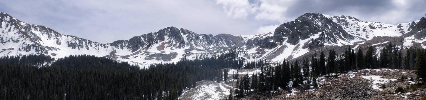
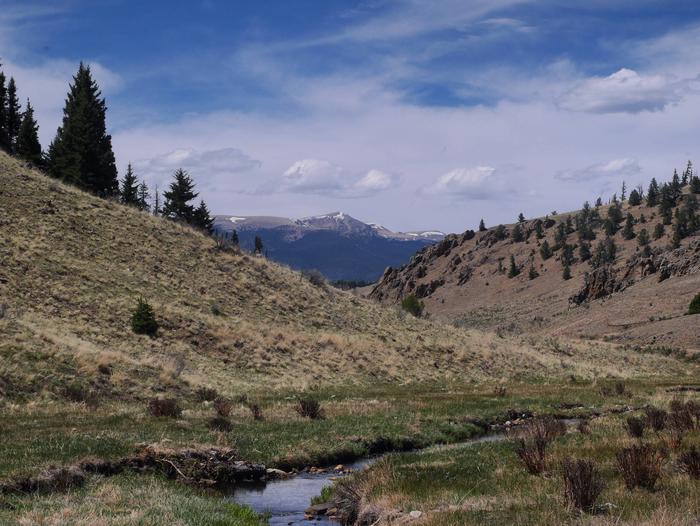
The Carson National Forest offers unlimited recreational opportunities in any season. The magnificent mountain scenery and cool summer temperatures lure vacationers to enjoy the peace and quiet, for fishing, hunting, camping, and hiking. Winter activities include skiing, snowshoeing and snowmobiling.
Wilderness Areas on the Carson National Forest.
Outfitter-Guide Program Analysis
The Carson National Forest is gathering information from interested stakeholders to conduct an Outfitter-Guide Needs Assessment.
RecAreaDirections
Open with Google Map
Misc
| Stay Limit | |
| Reservable | false |
| Keywords | |
| Map Link | |
| Contact Phone | |
| Contact Email |
Permits info
Facilities
HOPEWELL LAKE CAMPGROUND Campground
List of CampsitesOverview
Hopewell Lake Campground sits next to its scenic namesake lake between Tres Piedras and Tierra Amarilla in northern New Mexico. Visitors enjoy horseback riding, hiking, fishing and canoeing.Recreation
The 14-acre lake is perfect for canoeing and is regularly stocked with rainbow and brook trout. The Contiental Divide National Scenic Trail goes through the campgound, and is popular with horseback riders and hikers.Facilities
The campground has 31 camping sites. There is also a group day-use shelter and group overnight campsite, both available by reservation. Horse corrals and water troughs are available at two campsites. Vault toilets and drinking water are provided. First-come, first-served sites are available.Natural Features
Hopewell Lake is a small, man-made lake, set high in the Carson National Forest at an elevation of 9,500 feet. A forest of conifer and aspen trees covers the area and offers partial shade in the campground.contact_info
For facility specific information, please call (928) 537-8888.FAWN LAKES CAMPGROUND Campground
List of CampsitesOverview
Fawn Lakes Campground is located in Carson National Forest, one of a few campgrounds located along the scenic canyons of Red River. Visitors enjoy fishing and exploring nearby hiking trails.Recreation
Located between Questa and Red River, many activities such as hiking and fishing are available to visitors either at the campground or a short drive away. There is fishing access for Red River and to the nearby small lakes. Columbine Trailhead is within 4 miles and starts at Columbine Campground.Facilities
The campground contains 18 family overnight sites, of which three are tent-only sites. Vault toilets and drinking water are provided. Firewood is available for purchase from the host.Natural Features
The Red River runs adjacent to the campground. Two small fishing lakes are within a short walk from the campground. The surrounding mountains comprise a beautiful forest of ponderosa pine that blankets the campground and offers partial shade.contact_info
For facility specific information, please call (928) 537-8888.Nearby Attractions
The City of Red River is about 3 miles away, with groceries, gas, showers, laundry facilities and a café. An RV dump station is within 1 mile of the campground.CIMARRON CAMPGROUND Campground
List of CampsitesOverview
Cimarron Campground is located in the scenic Valle Vidal within Carson National Forest in northern New Mexico, at an elevation of 9,300 feet. The sites are tucked among spruce, aspen and fir trees, and the camp offers an open range feel.Visitors have opportunities to enjoy a variety of recreational activities in a picturesque setting. Viewing wildlife and simply relaxing in the mountain air are popular activities.
Recreation
Anglers can fish for Rio Grande cutthroat trout in Comanche Creek and the Rio Pueblo. Nearby Shuree Ponds offers excellent fishing. The smaller pond is a fishing hole for kids 12 and under. The main pond is stocked with rainbow trout and is also popular for float tubing.The area around the campground is open to horseback riding, and there are few maintained trails. Elk and deer hunting is excellent.
Facilities
The campground contains 36 overnight campsites, which includes nine horse sites, two double sites and 25 single-family sites. Vault toilets and drinking water are provided.
Sites are equipped with picnic tables and campfire rings with grills. Horse corrals and water troughs are available in the campground. A host is on-site.
Natural Features
Some of the finest mountain scenery in the Southwest is found in the 1.5 million acres within the Carson National Forest. Elevations range from 6,000 feet to 13,161 feet at Wheeler Peak, the highest in New Mexico.Big game animals roam the Carson, including mule deer, elk, antelope, black bear, mountain lion and bighorn sheep. Many species of smaller animals and songbirds can also been found in the forest.
Cimarron Campground is located within the beautiful Valle Vidal, a Spanish term meaning "Valley of Life," of the Sangre de Cristo Mountains. Shuree Ponds, Comanche Creek and the Rio Pueblo are all near the campground, offering excellent fishing.
contact_info
For facility specific information, please call (928) 537-8888.Agua Piedra Campground Campground
List of CampsitesOverview
Agua Piedra, located in the Carson National Forest, is nestled near the Rio Pueblo and Agua Piedra Creek. The campground contains many shaded areas to camp, relax, and enjoy the outdoors.Recreation
Visitors to the Agua Piedra campground and group shelters can also enjoy fishing in the Rio Pueblo River, which is a tributary of the mighty Rio Grande. The river is stocked with rainbow trout and has an accessible fishing dock. Hiking to Serpent Lake and Cordova Canyon, which are both within seven miles of the campground and group shelters, are also favorite activities for visitors. Also popular is further exploration of points of interest in the Pecos Wilderness, as well as within the Sangre De Cristos Mountains, the southernmost Rocky Mountain range.Facilities
The campground includes 40 single sites each with a table and fire ring, two double sites each with two tables and a fire ring, and two group shelters located west of the campground. Vault toilets, drinking water from faucets, and trash removal are provided. Firewood is available to purchase from the host. First-come, first-served sites are available. The group shelters (A and B), which are accessible, are located west of the campground and are equipped with tables and campfire rings with grills. Accessible vault toilets and drinking water are provided. Trash service is provided in the campground. The accessible group shelter "A" can accommodate up to 50 people for overnight camping. Group shelter "B" can accommodate up to 100 people for overnight camping. Both group shelters are available by reservation.Natural Features
Agua Piedra campground and group shelters are located in a mixed forest of spruce, fir and aspen trees, which provide some shade throughout the day. At an altitude of 8,100 feet, temperatures can cool off during the summer nights.Nearby Attractions
Sipapu Ski Resort, the town of Vadito, and the town of Penasco is within 3 - 17 miles from the campground and group shelter. Most services are available in Taos, NM, 25 miles north of the campground or Espanola, NM, 45 miles southwest.contact_info
For facility specific information, please call (928) 537-8888.Canjilon RD Facility

The Canjilon Ranger District is located in the beautiful mountains of Northern New Mexico. The elevation ranges from a low of 6,500 feet up to almost 11,000 feet above sea level. Climate and vegetation types vary from high desert to alpine zones. The ranger district contains several hiking trails, including the Continental Divide National Scenic Trail. There are three campgrounds located on the ranger district. The ranger district office is located in the small mountain village of Canjilon which contains a population of approximately 325 residents.
El Rito RD Facility
El Rito RD
Jicarilla RD Facility
Camino Real RD Facility
The Camino Real Ranger District is managed for many multi-use purposes; hunting, fishing, hiking, biking, skiing, snowmobiling, camping and personal firewood cutting are among the activities. The District manages many acres of the Carson National Forest. The District has more than 252 miles of trail, offering diverse terrain and dramatic landscapes for the skilled hiker.
Tres Piedras RD Facility
The Tres Piedras Ranger District is managed for many multi-use purposes; hunting, fishing, hiking, biking, skiing, snowmobiling, camping and personal firewood cutting are among the activities.
Questa RD Facility
The Questa Ranger District is managed for many multi-use purposes; hunting, fishing, hiking, biking, skiing, snowmobiling, camping and personal firewood cutting are among the activities.
La Sombra Campground Campground
List of CampsitesPopular Taos Canyon site near Capulin Campground and Shady Brook. No Drinking Water. No Garbage Service. Adjacent to Rio Fernando for Fishing.
Las Petacas Campground Campground
List of CampsitesSet in a beautiful canyon quite close to Taos, there is good access to Rio Fernando de Taos for fishing.
Junebug Campground Campground
List of CampsitesRecently refurbished roadside campground sits near historic Red River mining area and downhill ski resort. Can be very crowded during summer weekends. As an alternative, try BLM's Wild Rivers Recreation Area north of Questa.
McCrystal Campground Campground
List of CampsitesThese 55 sites in Valle Vidal elk/bear country are a great hunting, hiking, fishing destination.
From the town of Cimarron, drive 5 miles northeast on Highway 64 to Cerrososo Canyon. Follow this canyon approximately 21 miles to the Valle Vidal Unit Boundary. The route is marked by signs. From the boundary, travel 7 miles on Forest Service Road 1950. These graveled roads are not maintained during the rainy season and may be passable only with a four wheel drive vehicle.
La Bobita Campground Campground
List of CampsitesOverflow Campground.
Alamitos Creek Fishing Facility
Alamitos Creek can be accessed via Highway 518, east of Penasco. Camping is available at Angostura Campground.
Fish species found on Alamitos Creek include Rio Grande Cutthroat Trout and Brown Trout in the lower section.
Winter Site Ski Area Nordic Facility
Winter Site
Echo Amphitheater Picnic Site Facility
Echo Amphitheater is a natural amphitheater located on the Carson National Forest in Rio Arriba County, in northern New Mexico. The sandstone cliff is known for its unique echoing auditory properties. The red vertical stripes down the otherwise horizontally stratified cliff wall are streaks of mineral varnish that provides a colorful contrast to the sandstone cliff. This colorful geological feature combined with its unusual auditory properties no doubt fed the legend of myth associated with the Echo Amphitheater.
View more photos on the Carson National Forest Flickr site.
Flechado Picnic Site Facility
Flechado Picnic Site.
Taos Ski Valley Facility

Phone: (575) 776-2291
P.O. Box 90, Taos Ski Valley, NM 87525
Snow Report: (575) 776-2916 (updated daily)
Open: 9 am-4 pm
Peak Elevation: 11,819 feet
Base Elevation: 9,207 feet
Annual Snowfall: 317 inches
Terrain: 71 runs: 51% expert, 25% intermediate, 24% beginner
Snowmaking: 30% of beginner and intermediate
Average Temperature: 38 degrees
Lifts: 1 quad chair, 1 triple chair, 6 double chairs, 2 surface lifts
Uphill Capacity: 8,200 skiers per hour
Red River Ski Area Facility

Phone: (575) 754-2223
P.O. Box 900, Red River, NM 87558
Open: 9 am-4 pm
Peak Elevation: 10,350 feet
Base Elevation: 8,750 feet
Vertical Drop: 1,600 feet
Annual Snowfall: 190 inches
Terrain: 38 runs: 26% expert, 46% intermediate, 28% beginner
Snowmaking: 75% of trails
Average Temperature: 38 degrees
Lifts: 1 surface tow, 3 double chairs, 2 triple chairs
Uphill Capacity: 7,000 skiers per hour
Sipapu Ski Area Facility

Phone: (575) 587-2240
Sipapu Ski Lodge
Route Box 29, Vadito, NM 87579
Email: resort@sipapunm.com
Open: 9 am-4 pm (ski lift)
Peak Elevation: 9,100 feet
Base Elevation: 8,200 feet
Terrain: 19 runs; 20% beginner, 50% intermediate, 30% advanced
Snowmaking: 10% of trails
Lifts: 2 Pomas, 1 triple chair
Uphill Capacity: 2,900 skiers per hour Also: Cross-country and snowmobile trails.
Enchanted Forest Snowplay Area Facility
Enchanted Forest Cross Country Ski Area
P .O. Box 521
Red River, New Mexico, 87558
(575) 754-2374
Open: 9 am-4:30 pm
Peak Elevation: 10,300 feet
Base Elevation: 9,800 feet
Terrain: 19 miles (30k) of trails over 1,400 acres, signed with an accompanying map. Trails have tracks set and picnic areas. There are trails for all levels of skiers. Trail Fees.
Average Temperature: 38 degrees
Also: All day tours, moonlight tours and videotaping are available along with rentals, demos, and instruction. Whether you want to ski the tracks or make your own, panoramic views and great times await you.
Eagle Rock Lake Fishing Facility

Eagle Rock Lake Day Use Area on the Carson National Forest is one of the most popular recreations spots in the Questa area. Spreading across some three acres, it is a hot spot for both locals and visitors for fishing, picnicking, and hiking. The lake was recently completely rebuilt and redesigned.
The restoration of the lake began in 2015. Thanks to an extensive collaborative effort involving the Village of Questa, Chevron Mining, the Carson National Forest, EPA and state and federal agencies, contamination of sediment and ground and surface water was cleaned up. In addition, recreation facilities were upgraded, a walking path was created and the site was made ADA accessible. Stream restoration work was also completed around the lake.
The 4-year project to restore the lake was nationally recognized with the Greenovation Award from the Environmental Protection Agency. It has become a proud achievement for the community and marks the gateway for the bountiful recreational opportunities within Carson National Forest’s Questa Ranger District.
New Mexico Game and Fish stocks the lake on a regular basis from spring until fall. To protect the lake’s liner, swimming, boating and wading in the water are not allowed. Fishing in the Red River directly behind Eagle Rock Lake is fun as well. Fishing licenses are required and are available locally and online at http://www.wildlife.state.nm.us/fishing/licenses-permits/. New Mexico Game and Fish officers do check licenses occasionally.
Walking around the lake for exercise is also a popular year-around activity. One loop around the lake is approximately a half mile. There are plenty of parking spots, a clean restroom, and information on other recreational opportunities within the Carson National Forest.
If you are looking for that nice mountain lake getaway without the hassle of driving hours on a mountainous dirt road, or just looking to get in few laps surrounded by beautiful mountain vistas, then Eagle Rock Lake is the place for you.
Us Hill Snow Play Area Facility
Goose Lake Fishing Facility
Fishing at goose lake is accessible from Highway 38 at Red River, proceed south on Highway 578 to goose lake turnoff. Goose lake road is four wheel drive road.
Valle Vidal Unit Facility
The Valle Vidal has two campgrounds and numerous parking areas for those heading into the backcountry. The Campgrounds in the Valle Vidal Unit are the McCrystal and Cimarron campgrounds. The McCrystal campground sits at 8,100 ft., it has 60 units for camping and can accommodate a trailer 32’ and under.
The Cimarron campground sits at 9,400 ft., it has 35 camping units and can also accommodate a trailer 32’ and under.
Click here to view the Big Valle NatureWatch Viewing Site
Recreational Information on the Valle Vidal Unit
Columbine Creek Fishing Facility
Seven miles downstream from the town of Red River off of Highway 38. Stocked with rainbow
Costilla Creek Fishing Facility
Take highway 522 north to Costilla to highway 196 to Costilla Creek. Once you enter the Valle Vidal Unit it's catch and release. Fish species found on Costilla creek include Rainbow Trout, Brown Trout and Rio Grande Cutthroat Trout.
El Rito Creek Fishing Facility
The El Rito Creek can be accessed via Forest Road 559, North of the El Rito Ranger station. Brown Trout can be found in the lower reaches of the creek, and Rio Grande Cutthroat trout can be found above Salvador Canyon. Camping is available at El Rito Campground.
Lagunitas Creek Fishing Facility
Lagunitas Creek
Middle Ponil Creek Fishing Facility
Middle Ponil Creek is below Shuree Lodge, and Comanche Creek, along Forest Road 1950.
Red River Fishing Facility
From Questa to the town of Red River, stream is stocked with rainbow trout. Excellent fishing.
Rio Chama Fishing Facility
An excellent fishing stream that consistently produces trophy size brown trout. Access at El Vado lake and near Ghost Ranch. Section from El Vado Reservoir has been designated as a wild and scenic river. Fish species include brown trout, rainbow trout and kokanee salmon. A 34 mile stretch of river. Best trout fishing is within several miles of El Vado Dam.
Rio Chiquito Fishing Facility
Rio Chiquito can be accessed via Highway 518 to Forest Road 437.
Rio Fernando Fishing Facility
Rio Fernando Fishing
Rio Grande Fishing Facility
Trails lead down the side of 800 ft. gorge from Cebolla Mesa Campground and from the Bureau of Land Management Wild River recreation area.
From the Taos Junction Bridge (highway 567) northward to Colorado State Line. Reached mainly by trails. This river has been designated "Wild and Scenic". Excellent fishing for large brown and rainbow trout. Trails lead down the side of 800 ft. gorge from Cebolla Mesa Campground and from the Bureau of Land Management Wild River recreation area.
Angostura Fishing Facility
Angostura Creek can be accessed via Highway 518, east of Penasco. Camping is available at Angostura Campground.
Rio Nutritas Fishing Facility
Rio Nutritas Fishing
Rio Pueblo Fishing Facility
One of the most popular trout streams in the state. Paralleled by highway 518 along its entire length. Headwaters above Tres Ritos (Angostura and Alamitos Creek). Many campgrounds.
Rio Trampas Fishing Facility
Rio Trampas Fishing
Rio Tusas Fishing Facility
Can be accessed via Forest Road 222. Rainbow trout can be caught in this area.
Rio Vallecitos Fishing Facility
From El Rito take Highway 111 to access Rio Vallecitos. Brown Trout can be caught at Rio Vallecitos.
Rito De La Olla Fishing Facility
Rito De La Olla can be accessed via Highway 518 to Forest Road 438.
San Antonio River Fishing Facility
San Antonio River can be accessed via Highway 285 to Forest Road 87.
Shuree Lakes Fishing Facility
Take highway 522 north to Costilla to highway 196. From Valle Vidal Unit follow Forest Road 1950 to Shuree.
Tio Grande Fishing Facility
Tio Grande River can be accessed via Highway 285 to Forest Road 87. Brown Trout and some Rio Grande Cutthroat can be caught at Tio Grande River. Most of Tio Grande is on private land.
Trampas Lakes Fishing Facility
Trampas Lakes can be accessed via Highway 76 to Forest Road 207. From there you hike on trail 36 to Trampas Lake. Lake is in the Pecos Wilderness
Hidden Lakes Fishing Facility
Hidden Lakes Fishing
ELEPHANT ROCK CAMPGROUND Campground
List of CampsitesOverview
Elephant Rock Campground has excellent fishing access to the well-stocked Red River, nearby Eagle Rock Lake and hiking into the surrounding high country. This campground is close to the highway with plenty of large pine trees. The campground rests at 8,400 feet above sea level.Recreation
The nearest hiking trail, Fawn Lakes Trail, is located .3 miles east of Elephant Rock Campground, near Fawn Lakes Campground. This trail meets accessibility guidelines. Elephant Rock offers convenient access to State Rt. 38 and is well situated for day trips on the Enchanted Circle and to the town of Red River. The Red River is across the road from the campground but is not accessible.Facilities
This campground offers 20 single sites, potable water, and vault toilets. Each site has a fire ring, picnic table, and tent pad.Natural Features
Elephant Rock Campground is a single loop that meanders up a hillside with several sites featuring stone terracing. The campsites are tucked in among a mixture of ponderosa pine, aspen, fir and spruce. The Red River flows near this campground.Nearby Attractions
Visitors to the area can explore the town of Red River, Questa, and the Enchanted Circle.contact_info
For facility specific information, please call (928) 537-8888.COLUMBINE CAMPGROUND (NM) Campground
List of CampsitesOverview
Columbine Campground is located between Questa and Red River, New Mexico. The Red River flows past the campground and a trailhead leads into the Columbine-Hondo Wilderness area. Columbine Campground sits at 7,900 feet in elevation.Recreation
The Columbine Twining hiking trail can be found at the south end of the campground and gives access to 14 miles of hiking trails, and leads into the Columbin-Hondo Wilderness area. The Red River runs near the campground and can be accessed near the first loop.Facilities
This campground offers 26 single sites, potable water, and vault toilets. Each site is has a fire ring, picnic table, and tent pad. Please note that no water can be filled directly into a trailer, rv, or motorhome anywhere in this campground - the potable water is only for filling containers you bring back to your site.
Natural Features
The campground is composed of two loops. One small loop at the campground entrance, has all open sites and views of the towering mountains. The other is a long loop up the canyon along the fast-flowing Columbine Creek. The campsites in this loop are tucked in among pine, spruce and some aspen providing ample shade and good privacy between campsites.contact_info
For facility specific information, please call (928) 537-8888.Nearby Attractions
Be sure to explore Red River, Questa, and the Enchanted Circle while in the area.Canjilon Lakes Picnic Site Facility
Canjilon Lakes
Little Rio Grande Fishing Facility
Little Rio Grande Creek can be accessed via Highway 518, south of Taos.
SANTA BARBARA CAMPGROUND Campground
List of CampsitesOverview
Santa Barbara Campground is situated nicely on the edge of the Pecos Wilderness area and next to Rio Santa Barbara, a beautiful and healthy trout stream.Recreation
This is a great drop off point for hikers and horseback riders seeking close access to the Pecos Wilderness and Jicarita Peak.Facilities
The campground has 15 single sites, each containing a table and fire ring; two double sites, each containing two tables and a fire ring; one triple site containing three tables and a fire ring; and two quad sites containing four tables and a fire ring. Vault toilets, drinking water from faucets and trash removal are provided. There are no horse facilites within the campground. First-come, first-served sites are available.Natural Features
Santa Barbara is located in a mixed forest of spruce, fir and aspen trees, which provide some shade throughout the day. At an altitude of 8,900 feet, temperatures can cool off during the summer nights.Nearby Attractions
Trail access to Jicarita Peak, with close access to North Truchas Peak, Sipapu Ski Resort, the town of Vadito, and the town of Penasco are all nearby. All are within 8-15 miles from the campground. Most services are available in Taos, NM, 25 miles north of the campground or Espanola, NM, 45 miles southwest.contact_info
For facility specific information, please call (928) 537-8888.AMOLE CANYON GROUP SHELTER Campground
List of CampsitesOverview
The Amole Group Shelter is located immediately adjacent to the popular wooded Amole Canyon Day Use Area at 8,400 feet in elevation. The group shelter accommodates up to 100 people with plenty of solitude since this is the only group facility in this location.
Recreation
There are approximately 11 miles of non-motorized trails located in the Amole Canyon Day Use Area. Here, visitors can enjoy sections of the nearby South Loop Trail, with views of the Rio Pueblo Valley, and nearby Bear Mountain and Penasco Mountain. Along the Upper Cutoff Trail, views of Picuris Mountain are readily available. The trails are popular for hiking, mountain biking, snowshoeing and cross-country skiing and are rated easy to more difficult. The Amole Canyon Trailhead also provides access to the Forest's Motorized Trail System via Trail 182, the Tio Maes Trail.
Facilities
This location provides gated access, twin barbecue grills, picnic tables and a group-sized fire ring. In addition, accessible twin vault toilets with a paved path to the shelter are provided. There is no water at this facility and no trash service. Please bring all the water you will need for your stay and pack out your trash.
There is group camping for up to 100 people with 4 paved single vehicle parking spots, and gravel spots for passenger vehicles OR camper trailers/RVs. All designated parking is surfaced with gravel or pavement. The pull-thrus can either be used for passenger vehicles or RVs and camp trailers. All parking, regardless of vehicle type, must be on surfaced parking areas.
Natural Features
The group camping area has been constructed within a stand of tall ponderosa pine trees. The shelter has been constructed on a small hill overlooking a pristine meadow.Nearby Attractions
Amole Canyon Group Shelter is located approximately seven miles away from the unincorporated community of Penasco with art galleries, some restaurants, fuel and automotive services, and a small hardware store; seven miles from Sipapu Ski and Summer Resort with a resturant and a nationally ranked disc golf course; eight miles from the Taos Campus of Southern Methodist University and the Pot Creek Cultural Site; 11 miles from Picuris Pueblo with stocked fishing ponds and a disc golf course; 15 miles from Taos with a hospital and most services; 15 miles from access to the Pecos Wilderness and world class fly fishing at the Santa Barbara Trailhead; 20 miles from the Serpent Lake Trailhead which accesses the Pecos Wilderness and Jicarita Peak (12,800 feet); 20 miles to Taos Pueblo with events and pueblo tours; and 30 miles from the Rio Grande del Norte National Monument with word class rafting, kayaking and flying fishing.
