
Cibola National Forest and Grasslands
Cibola National Forest & National Grasslands
Acreage: 1,625,542
Elevation: 2,700 feet -11,300 feet
The mountain ranges of the four forested districts of Cibola National Forest and National Grasslands include: the Datil, Gallinas, Magdalena, Bear, San Mateo, Zuni, Sandia and Manzano mountains, as well as the Manzano, Withington and Apache Kid wildernesses. These are all located in central New Mexico. The Cibola National Forest also includes 263,954 acres of national grasslands in northeastern New Mexico, western Oklahoma, and northwestern Texas.
CLIMATE: Climate within the Cibola National Forest and National Grasslands varies with elevation - from the desert up through juniper, pine, and spruce-fir forests. Summer nights are cool, and very cold above 8,000'. During July and August there are frequent afternoon showers.
Sandia Crest elevation is 10,678 feet and is accessible by car, aerial tramway and trail. Capilla Peak’s elevation is 9,375 feet and is accessible by car. Mount Taylor peaks at an elevation of 11,301 feet and has a road within a mile of the top. The Cibola National Forest also offers several other scenic drives on its districts.
ACTIVITIES: Cibola National Forest and National Grasslands offers good deer hunting as well as some elk, antelope, and turkey hunting. Fishing opportunities are available at Bluewater and McGaffey Lakes in the Zuni Mountains, Skipout, Spring Creek, and Dead Warrior Lakes in Oklahoma, and Lake Marvin and Lake McClellan in Texas. Nearby attractions also include the Sandia Peak Ski Area in the Sandia Mountains, the Very Large Array by the Magdalena Ranger District, prehistoric ruins, ice caves, lava flows, and Indian pueblos.
RecAreaDirections
New Mexico
Open with Google MapMisc
| Stay Limit | |
| Reservable | false |
| Keywords | |
| Map Link | |
| Contact Phone | |
| Contact Email |
Permits info
Facilities
COAL MINE Campground
List of CampsitesOverview
Coal Mine Campground is situated in the upper portion of the Cibola National Forest in west-central New Mexico. Visitors enjoy hiking the Coal Mine Canyon Nature Trail, as well as picnicking and scenic driving.Recreation
The Coal Mine Canyon Nature Trail begins in the campground and leads hikers less than half a mile on a path through the forest. A variety of additional hikes and points of exploration are nearby.
Visitors also enjoy picnicking in the surrounding area. The Sandia and Manzano Mountains offer extensive stretches of scenic drives.
Facilities
The campground offers more than a dozen sites for tent or RV camping. Each site can accommodate up to 10 people. Utility hookups are not available. Some parking spurs are paved, while others are gravel.Each site is equipped with a table and campfire ring with grill. Accessible vault toilets are provided. Drinking water is not available in the campground; visitors must bring their own supply.
Natural Features
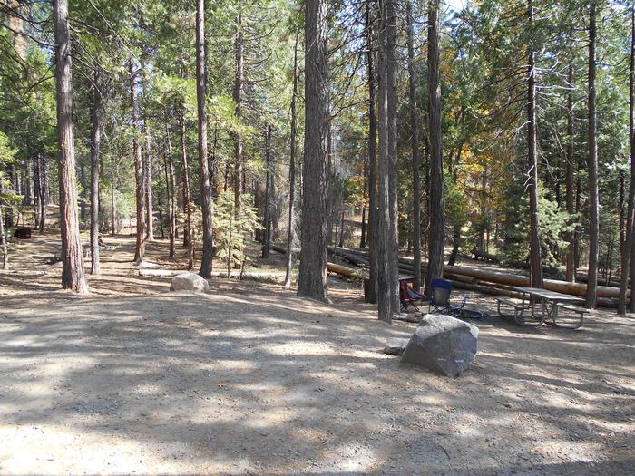
The campground is located northeast of the town of Grants at an elevation of 7,400 feet. It lies on the top of a hill, with campsites situated on gently sloping ground. A forest of mature pine, juniper and oak trees surrounds the campground.Nearby Attractions
The El Malpais National Monument and Conservation Area can be accessed from various points within a short drive of the campground. Its extensive, ancient lava flow landscape and other scenic features draw tourists year-round.Points on interest within the monument and conservation area include the Northwest New Mexico Visitor Center, Sandstone Bluffs Overlook and La Ventana Natural Arch. A portion of the Continental Divide National Scenic Trail parallels the Zuni-Acoma Trail as it passes through the monument.
The city of Grants is about 12 miles from the campground, offering dining and lodging options. The city also boasts a mining museum with gem and mineral displays and a self-guided tour into an underground world.
Charges & Cancellations
A $10.00 service charge will apply if you change or cancel your reservation. Late cancellations are subject to additional fees. For full details see NRRS Reservation Policy.CAPULIN SPRING PICNIC SITE Campground
List of CampsitesOverview
Capulin Spring is a well-loved recreation spot. It accommodates fifty people. This picnic site is surrounded by heavily wooded land that affords shade to escape the heat of the day. The spring at Capulin Spring runs year-round and is a much visited spot by birders, especially in the dry season because thirsty birds flock to this area for a nice, cool drink of water. Look for the big log and you will find beautiful birds of all types, sizes and colors. Remember to bring your camera.
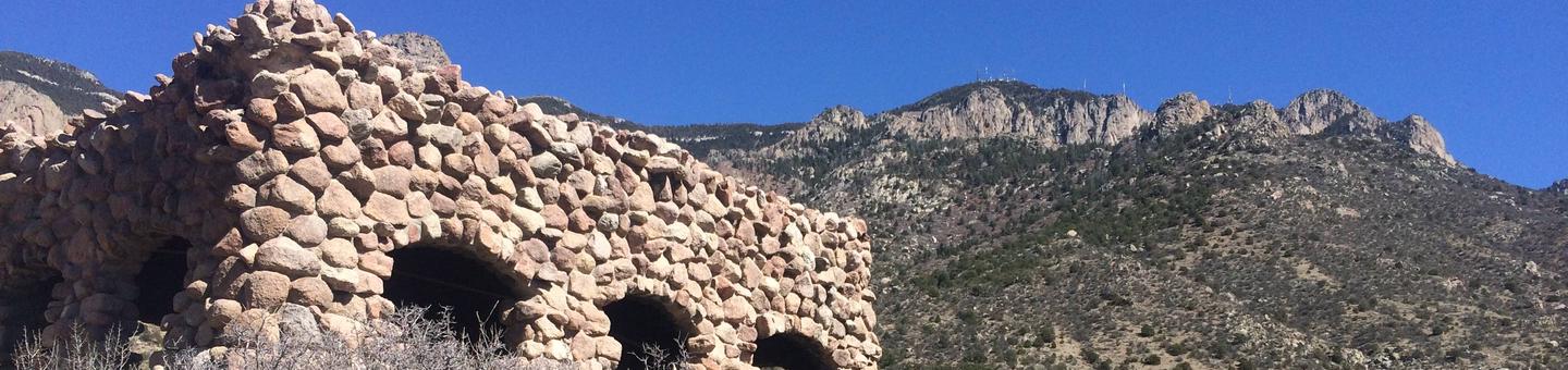
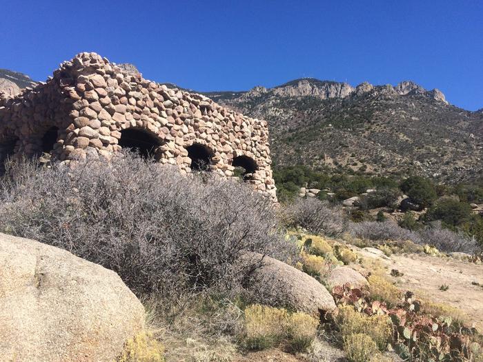
The sheltered area is a replica of a mid-1930s Civilian Conservation Corps design. The Civilian Conservation Corps (CCC) has a rich history and lasting presence throughout the Sandia's. In their honor, we ask that you take extra care to "leave no trace" when you visit. Please be aware that there is no overnight camping at Capulin Spring.
Recreation
The Capulin Peak Trail starts at the Capulin Snow Play Area parking lot and is about .6 miles to the summit, with only 150 feet of elevation gain. It is shady for the most part but the final leg of the trail is rocky with lots of scrub brush. Just below the summit on the main trail are the ruins of an old mining shack and mining pit. Another option is Capulin Spring trail. It is a short walk down the hill on the service road. It is a popular location for bird watching and photography. These trails are suitable for children and adults to enjoy.Facilities
The reservation site can accommodate up to 50 people. Capulin Picnic Site includes a group picnic shelter, that is a modern day version of the Civilian Conservation Corps design found in most all of our picnic areas, six accessible picnic tables, food prep/serving tables and two large pedestal charcoal grills. The picnic pad, pathways and parking area are paved and accessible. **Water and Electricity, firewood /charcoal are not available at the site. Accessible vault toilets and bear proof trash receptacles are provided. PARKING: Each reservation comes with ten day use parking passes which should be picked up before hand, at the Sandia Ranger Station, Monday through Friday between 8:00 a m and 4:30 p m, (505) 281-3304. *Additional dispersed picnic areas, which do not require a reservation, are available on a first-come,first-served basis. Each area can accommodate a small family group and have no covering. Tables and grills are provided.Natural Features
Capulin Spring is located two miles above Sandia Peak Ski Area at an elevation of 8,740 feet. It has hills and is heavily wooded around the perimeter of the site. There is a year-round spring that runs through it. The Sandia's are home to mule deer, black bear, mountain lions and many other species of wildlife and birds, including golden eagles often seen soaring overhead.Nearby Attractions
It is a short trip to the Sandia Crest. Take a right out of the Capulin parking lot and continue up Scenic Byway 536 to the top, for a magnificent view of Albuquerque and surrounding areas from the Sandia Crest overlook. The Crest was voted "Best Place to Pop the Question" in 2010... and it still is! The Kiwanas Cabin was built by the CCC in the 1930s and is located south of the Sandia Crest and can be seen from the Crest observation deck. The Peak area provides two launch pads for hang gliding, which is a popular sport during summer months. On summer weekends the Sandia Peak Ski Area lift makes runs to the top where the Sandia Tram and High Finance Restaurant are perched. Turn left out of Capulin Spring onto State Road 536. The ski area is a short distance down the road and located on the right side of the 536. For more info: (505)242-9052 or (505)856-1532. There are privately owned businesses and restaurants all along NM State Road 14 and a museum on your way up the 536 Scenic Byway.PINE FLAT PICNIC SITES - A and B Campground
List of CampsitesOverview
Pine Flat picnic sites A & B is an accessible picnic area. It is located on State Highway 337 (James McGrane Memorial Highway or Old South 14) approximately 7 miles from I-40. State Hwy 337 runs parallel to Pine Flat picnic area making it easy to identify and enter. From the entry way to your left you will find two reserve only sites. The area is surrounded by pinon, juniper, scrub oak and ponderosa pine that lend shade to both reservation areas. Cool mountain breezes are common here. The sound of rustling foliage render Pine Flat picnic sites an excellent place to lean back, relax and maybe even take a nap. Each site can accommodate fifty people.
Pine Flat Trailhead has pull through trailer parking in addition to regular vehicle parking, which is located to the right as you enter the gate. Follow the road south to the trailhead that leads into the Manzanita Mountains Trail system.
You will also find dispersed picnic tables throughout the Pine Flat sites, which are available on a first-come, first-served basis. Pine Flat Sites A & B were built in 1956 by the Forest Service with the intent to provide picnic sites for large group use. Please take care of your public land by using Leave No Trace ethics. There is no overnight camping at this site.
Recreation
Pine Flat connector trail leads to a multiuse motorized trail system. The trail system has loops and straightaways to satisfy just about any recreationist. For more information on OHV use, consult the District Motor Vehicle Use Map.Facilities
As you enter the area, to the left you will find two reserve only sites, A and B. Both sites have grills, tables, vault toilets and bear proof trash containers.
The trailering area for horse and motorcycle trailers is located to the right as you enter the gate. Follow the road south to the trailhead that leads into the Manzanita Mountains Trail system.
Dispersed picnic tables are available on a first-come, first-served basis. They are located throughout the area along the east side of the Pine Flat site.
Water and electricity, firewood/charcoal are not available at the site. Accessible vault toilets and bear proof trash receptacles are provided. Bears frequent the area; More about Bears and Food.
Have questions? (505) 281-3304.
Natural Features
Pine Flat picnic ground is 7,240 feet in elevation. It is fairly flat which makes it easy to park a trailer and unload your OHVs or horses. Hikes in the surrounding area can vary in elevation by approximately 50-120 feet.Nearby Attractions
The historic Cedro Cemetery and the town of Tijeras are about five miles from the picnic area.NINE MILE PICNIC SITE Campground
List of CampsitesOverview
**Nine Mile Picnic Site is currently closed for improvements**
If you are looking for a quiet, relaxing, cool spot with a slight breeze, Nine Mile Picnic Site could be just what the doctor ordered. Nine Mile Picnic Site is located just off State Road 536 near the nine mile marker on the left side as you wind your way up State Highway 536. It is surrounded by aspen, spruce and fir trees. In the fall, the aspens cast a golden hue over the entire area, which creates an alluring draw to the picnic area. Nine Mile has old paved roadways within the picnic site that are just right for a short walk through the forested area.
Please remember to take extra care to "Leave no trace" when you visit your public lands. There is no overnight camping at Nine Mile.
Recreation
Picnicking and relaxing are the main activities in Nine Mile Picnic Site.Facilities
This facility can handle up to 50 people. There is no shelter, but there is plenty of shade provided by the aspen, spruce and fir trees that grow within Nine Mile. It is peaceful.Water and electricity, firewood /charcoal are not available at the site. Accessible vault toilets and bear proof trash receptacles are provided. Bears frequent the area; use appropriate containers for food and garbage.
PARKING: Each reservation comes with ten day use parking passes which should be picked up before hand, at the Sandia Ranger Station, Wednesday through Friday between 8:00 a.m. and 4:30 p.m., (505) 281-3304.
*Additional dispersed picnic sites, which do not require a reservation, are available on a first-come, first-served basis. Each site can accommodate a small family group and have no covering. Tables and grills provided.
Natural Features
The area is heavily wooded, with a mixture of level and hilly ground.Nearby Attractions
There are privately owned businesses and restaurants all along NM State Road 14 and a museum on your way up the 536 Scenic Byway.If you are interested in taking a short jaunt to the very top of the Sandia Mountains, just take a left turn out of the Nine Mile parking area, onto the Sandia Crest 536 Scenic Byway, and wind your way up. The Byway extends 13.6 miles from the base of the Sandia to the Sandia Crest.
At the Sandia Crest there is parking, a gift store, snack bar and a lookout deck. There you can see panoramic views from any direction you look. Sunsets are spectacular. It was voted Best Place to "Pop the Question" in 2010. It is a popular path for motorcyclists and auto touring, with its winding road to the peak.
The Peak area provides two launch pads for hang gliding, which is a popular sport during summer months.
BALSAM GLADE PICNIC SITE Campground
List of CampsitesOverview
Balsam Glade Picnic Site was named by an early American settler who mistook the white fir that grows here for balsam fir, as they are similar in appearance. He called this area "Balsam Glade" for so long that the name stuck.
From 1935 to 1941 the YMCA operated a summer camp for boys here. One young man who attended the camp as a youth, later became a counselor for boys at the "Y" camp. He was a fun loving fellow and gained the title "Ghost of the Sandia's"
for his wild antics, like flying over the campfire on a zip line and scaring the campers. The only evidence of the 'Y' camp are two sets of steps that led thousands of hungry kids into the dining hall and out again to make more memories.
Balsam Glade is a great place for you and yours to make your own memories. The surrounding forest and mountains provide a perfect backdrop for photography, flower walks, bird watching, hiking, relaxing and taking in nature and other recreational opportunities. Please note that there is no overnight camping at this picnic site.
The sheltered area is a replica of a mid-1930s Civilian Conservation Corps design. The Civilian Conservation Corps (CCC) has a rich history and lasting presence throughout the Sandia's. In their honor, we ask that you take extra care to "leave no trace" when you visit.
Recreation
The nature trail within this picnic site is well suited for any age, young or old. It is .3 (three tenths) of a mile long, with very little elevation gain. It leads from the reserved site to an overlook at Madera Canyon. There you will find an observation deck where many lovers have sealed their devotion to one another thru wedding vows. Resting places and informative signage along the path give opportunity to relax and learn as you go.There is also an overgrown pathway that leads northwest from Balsam Glade toward the Capulin Picnic site. These trails are suitable for children and adults to enjoy hiking in the great outdoors.
Facilities
Water and electricity, firewood/charcoal are not available at the site. Accessible vault toilets and bear proof trash receptacles are provided.
Balsam Glade picnic site has one covered shelter, which is a replica of a mid-1930s Civilian Conservation Corps design. It can accommodate up to 30 people and is equipped with multiple picnic tables and grills.
PARKING: Each reservation comes with ten (10) day use parking passes which should be picked up before hand, at the Sandia Ranger Station, Monday through Friday between 8:00 a.m. and 4:30 p.m., (505) 281-3304.
Additional dispersed picnic sites, which do not require a reservation, are available on a first-come, first-served basis. Each site can accommodate a small family group and have no covering. Tables and grills provided.
Natural Features
The picnic site is located at an elevation of about 8,650 feet. It is adjacent to La Madera Canyon Overlook with views of South Mountain. Elevation gain throughout this site is minimal. La Madera Overlook affords views of the eastern Sandias and beyond. Hawks and turkey vultures fly through the canyon in graceful circles scouting for food. A fault line reveals pre-Cambrian rocks intermixed with ancient Sandia granite. Mountain mahagony grows near the overlook on the sunny and drier slopes. Yucca, pinon and juniper trees grow here also, above their normal vegetation levels creating a diversified ecosystem.Nearby Attractions
There are privately owned businesses and restaurants all along NM State Road 14 and a museum on your way up the 536 Scenic Byway.If you are interested in taking a short jaunt to the very top of the Sandia Mountains, take a right turn out of the Balsam Glade parking area, onto the Sandia Crest 536 Scenic Byway and wind your way up. The byway extends 13.6 miles from the base of the Sandia's to the Sandia Crest, where you will find parking, a gift store, snack bar and a lookout deck. There you can see panoramic views from any direction you look. Sunsets are spectacular. It was voted Best Place to "Pop the Question" in 2011. It is a popular path for motorcyclists, with its winding road to the peak.
The Peak area provides two launch pads for hang gliding, which is a popular sport during summer months.
Charges & Cancellations
$10.00 non refundable processing fee through recreation.govCIENEGA PICNIC SITE Campground
List of CampsitesOverview
Beautiful, shady, cool and green are just a few words that recreationists have used to describe the Cienega Group Picnic site. It is fairly flat, accessible, semi-private and accommodates up to fifty people. There are grills, bear proof trash containers and vault toilets provided and no shelter other than the surrounding shade trees. A stream, which draws birds and other wildlife, runs through the area. There is no overnight camping at Cienega.
Cienega's accessible interpretive trail/sidewalk winds around the picnic site and provides a great learning experience for those who take the time to check it out. There is an accesible patio near the beginning of the interpretive trail that is suitable for a picnic. All you need is a folding table for everyone to gather around at mealtime.
Whether it's a picnic or a wedding, Cienega Picnic site is a beautiful setting in which to enjoy the outdoors.
Recreation
A variety of hiking and horseback riding trails are available from within the picnic area, including one leading to the mountain crest. The nearly 10-mile round-trip trail winds through a fir forest, abundant with wildflowers. Much of the hike is in the shade, although the terrain can be rough. Day hikes are available along the route. In non-drought times, the trails follow a mountain stream with a beautiful travertine waterfall. Make sure to bring a detailed trail map such as the Sandia Mountain Wilderness map, or the Sandia Mountain Trails Guide.An accessible interpretive trail leads along the nearby stream and meadow, called "La Cienega" which means wet meadow. This unique trail was cooperatively built, by the New Mexico Association for the Blind and the Forest Service, for persons with a disability or otherwise limited physical mobility.
Facilities
The picnic site offers a semi-private space that can accommodate up to 50 people. There is no shelter, however, the trees provide plenty of shade.Water and electricity, firewood/charcoal are not available at the site. Picnic tables, grills, accessible vault toilets and bear proof trash receptacles are provided. Bears frequent the area; please use appropriate containers for food and garbage. Food Storage Keeping You and Bears Safe
Natural Features
Located approximately a half mile off the 536 Scenic Byway, the Cienega Picnic site is fairly flat. There is a stream that runs through it, that has created a wet meadow. It is encircled by trees and an interpretive trail/sidewalk.Nearby Attractions
There are privately owned businesses and restaurants all along NM State Road 14 and a museum on your way up the 536 Scenic Byway as you head toward Cienega Group Picnic area.If you are interested in taking a short jaunt to the very top of the Sandia Mountains, just take a left turn out of the Cienega Group Picnic site parking area, to 536, and then another left onto the Sandia Crest 536 Scenic Byway, and wind your way up.
At the Sandia Crest there is parking, a gift store, snack bar and a lookout deck. There you can see panoramic views from any direction you look. Sunsets are spectacular. It was voted Best Place to Pop the Question in 2011. It is a popular path for motorcyclists and auto touring, with its winding road to the peak.
The Peak area provides two launch pads for hang gliding, which is a popular sport during summer months.
DOC LONG PICNIC SITES - A and B Campground
List of CampsitesOverview
Doc Long Picnic Sites is named for Dr. William Henry Long. He was one of three forest pathologists in the USA who conducted pioneering research of tree diseases.
Doc Long, worked in New Mexico from 1910 through the 1930s. Doc lived in a cabin on the site where the "furthest set", rustic log pavilion is now. The original pavilion and picnic ground were constructed in 1935 by the Civilian Conservation Corps, also known as the CCC. Their base camp was located a short distance down State Road 536 and is now owned by the Boy Scouts of America. Pavilions A and B were added later and are adjacent to the road next to the small playing field.
The Civilian Conservation Corps has a rich history and lasting presence throughout the Sandia Mountains. In their honor, we ask that you take extra care to "leave no trace" when you visit. Please note that there is no overnight camping at Doc Long.
Recreation
There is access to hiking, mountain biking and horseback riding trails from Doc Long. Bill Spring Trail, Oso Corridor Trail, Faulty Trail and a short pathway leading to Sulphur and Cienega picnic sites are connected to Doc Long for easy access.The site's playing field can accommodate outdoor activities that will make your picnic a memorable one for everyone. Help your kids explore the ecosystem, and its related plants and animals through our Junior Ranger program. For more information about the Junior Ranger program, call the Sandia Ranger Station at (505) 281-3304.
The surrounding forest and the majestic mountains provide a beautiful location for sightseeing, hiking, and outdoor recreation. Bring your camera.
Facilities
Water and electricity, firewood/charcoal are not available at the site. Accessible vault toilets and bear proof trash receptacles are provided. For details, please read the "Know Before You Go" below.Doc Long offers two large, accessible group picnic shelters, which are replicas of the 1930s Civilian Conservation Corps design. Each can accommodate up to 30 people and are equipped with multiple picnic tables and grills. The site features a playfield area adjacent to the group shelters, interpretive displays, and a visitor information "hut" staffed by friendly volunteers. The "hut" is typically open on weekends, May 15 through October 14, to welcome visitors and provide information and assistance.
PARKING: Each reservation comes with ten (10) day use parking passes which should be picked up before hand at the Sandia Ranger Station, Monday through Friday between 8:00 a.m. and 4:30 p.m., (505) 281-3304.
*Additional dispersed picnic areas, which do not require a reservation, are available on a first-come, first-served basis. Each area can accommodate a small family group and have no covering. Tables and grills are provided.
Help to prevent bug kill. Obtain firewood near your destination and burn it on-site: Don't Move Fire Wood.
Learn more about the recreation opportunities in theCibola National Forest & Grasslands , including the Sandia Mountain Trails and the history of the Civilian Conservation Corp .
Natural Features
The picnic area is at an altitude of 7,360 feet. It is nestled in a dense forest of towering ponderosa pines and is surrounded by mountainous terrain.The Sandia's are home to mule deer, black bear and many other species of wildlife and birds, including the red-tailed hawk, predator of the playful Abert's squirrel, who is a year-round resident of the Doc Long site.
Nearby Attractions
There are privately owned businesses and restaurants all along NM State Road 14 and a museum on your way up the 536 Scenic Byway which extends 13.6 miles from the base of the Sandia's to the Sandia Crest.At the Sandia Crest there is parking, a gift store, snack bar and a lookout deck. There you can see panoramic views from any direction you look. Sunsets are spectacular. It was voted Best Place to "Pop the Question" in 2010. It is a popular path for motorcyclists and auto touring, with its winding road to the peak.
The Peak area provides two launch pads for hang gliding, which is a popular sport during summer months.
LAS HUERTAS PICNIC SITE Campground
List of CampsitesOverview
Las Huertas was built by the Civilian Conservation Corps. It is located at the northeast end of the Sandia Ranger District. It is, understandably, a favorite place for many. Las Huertas Creek meanders year round through this recreation site. Pathways and foot bridges lead over the water and through the trees to dispersed picnic tables and grills that are tucked away in the woods. The group site pavilion is a replica of the 1930s Civilian Conservation Corps design.
Las Huertas was a side camp for the Civilian Conservation Corps from 1933 to 1941. The Civilian Conservation Corps (CCC) has a rich history and lasting presence throughout the Sandias. In their honor, we ask that you take extra care to leave no trace when you visit. Please note that overnight camping is not allowed.
Recreation
Picnicking and bird watching are favorite pastimes at this site.Facilities
Drinkable water and electricity, firewood /charcoal are not available at the site. Accessible vault toilets and bear proof trash receptacles are provided.The accessible picnic site has a covered shelter that can accommodate up to 30 people. It is equipped with multiple picnic tables and grills. Accessible vault toilets are provided.
PARKING: Each reservation comes with ten (10) day use parking passes which should be picked up before hand, at the Sandia Ranger Station, Monday through Friday between 8:00 a.m. and 4:30 p.m., (505)281-3304.
Additional dispersed picnic sites, which do not require a reservation, are available on a first-come, first-served basis. Each site can accommodate a small family group and have no covering. Tables and grills provided.
Natural Features
The site is located on the east side of the Sandia Mountains, at an elevation of 7,600 feet. Las Huertas is adjacent to the only year-round stream in the range and can be heard throughout the picnic area. The water draws birds and other wildlife to the picnic grounds. Aspen and fir trees surround the area, providing shade from the sun.Nearby Attractions
Sandia Man Cave is a short drive north. The parking lot for the cave is on the right or east side of the road. No fee is required. The town of Placitas is approximately 6-7 miles north and offers restaurants and a few gift stores. Bernalillo is not far away with hotels and other amenities.Cedro Peak Camping Sites - Robin and Jay Campground
List of CampsitesOverview
Cedro Peak Camping Sites is a favorite area in the southern portion of the Sandia Ranger District. It is encompassed by ponderosa pine, pinon and juniper trees. Both Cedro Peak camping sites are fully accessible and have plenty of parking. Jay site has a circular turn around drive for those who might bring a small travel trailer.Recreation
Cedro Peak Camping Sites has room for outdoor games as well as access to the best trail system for mountain biking in the Cibola National Forest. A variety of hiking, mountain biking, horseback riding and off-road vehicle trails connect with the camping area. The region features more than 80 miles of single-track and equestrian trails. Mountain biking trails in the area can accommodate intermediate to advanced riders. The trails offer expansive views of the Sandia Mountains to the north, the Manzanos and the Cedro Peak Camping Site. Limited off-road vehicle trails are available as well.Please use Leave No Trace ethics when using your public lands.
Facilities
The campground offers two large, fully accessible group campsites.
-Jay can accommodate up to 100 people and 27 vehicles. Rates: $60 for 1-50 people, $80 for 51-75 people, and $100 for 76-100 people.
-Robin can accommodate up to 150 people and 41 vehicles. Rates: $60 for 1-50 people; $80 for 51-75 people, $100 for 76-100 people, $125 for 101-125 people, and $150 for 126-150 people.
Each site is equipped with grills and tables, some of which are covered by picnic shelters. Large campfire circles are also available. Water and electricity, firewood/charcoal are not available at the site. Accessible vault toilets and bear proof trash receptacles are provided. Bears frequent the area; use appropriate containers for food and garbage.
Gate Lock Combination: The combination for the gate lock will be provided in your reservation confirmation email. Have questions? Call the Sandia Ranger District Office, Monday through Friday between 8 a.m. and 4:30 p.m. at (505) 281-3304.
Natural Features
The group campground is located in the Manzanita Mountains at an elevation of about 7,400 feet. It is eight miles south off of I-40. The campground is nestled in a pinon pine and juniper forest, amid the arid, hilly landscape.Charges & Cancellations
There is a $10 non-refundable reservation fee through recreation.govOak Yucca and Locust Group Picnic Sites Campground
List of CampsitesOverview
The Oak Flat Group picnic site includes a combination of three different picnic sites and a trailhead, that border four communal playing fields suitable for all sorts of outdoor games. The site is paved and accessible. It is a great place for play, rest and recreation. The picnic sites are surrounded by ponderosa pine forest, mixed with oak, piaon, juniper, and plenty of yucca plants -- New Mexico's state flower. You can look at the day use map, to choose your reserved picnic site, by clicking on the tab above this overview. There is no overnight camping at this site.
The sheltered sites are replicas of the mid-1930s Civilian Conservation Corps design. The Civilian Conservation Corps (CCC) has a rich history and lasting presence throughout the Sandias and Manzanitas. In their honor, we ask that you take extra care to leave no trace when you visit.
Recreation
There are four large, shared playing fields perfect for outdoor activities. Want to hike? Oak Flat Trailhead leads into a widespread, multiuser trail system shared by mountain bikers, hikers, horseback riders and dirt bikes. The parking lot is small, but is able to accommodate small trailers for horses and motorcycles. However, we suggest horseback riders use the Pine Flat picnic site for trailering. It is located on State Hwy 337. The trail from Pine Flat connects to the Oak Flat site trail system, has larger trailering parking slots and is a shorter drive from I-40 and Historic Route 66/333. Pine Flat also has two reservation sites for picnicking.If you stay into the evening, the stars will dazzle you. Once a month from May to September, the Albuquerque Astronomical Association has a STAR PARTY. You can find the link to info, in the Know Before You Go section.
Facilities
The Oak Flat Group picnic site features three picnic sites and a trailhead. The trailhead connects to an extensive trail system plus four big playing fields. -Oak Flat- Oak Picnic site is the largest of the three sites in the Oak Flat Picnic Loop. It has a huge paved area with enough tables and grills to handle 1 to 500 people. -Locust Picnic site has a shelter and can handle 1-125 people. -Yucca Picnic site has a shelter and can accommodate 1-60 people. -Oak Flat Trailhead is located past Locust picnic site, which is to your left when you enter the Oak, Yucca and Locust Group Picnic Site. Water and electricity, firewood/charcoal are not available at these sites. Accessible vault toilets and bear proof trash receptacles are provided. More about Bears and FoodNatural Features
The Oak Flat Group picnic site is just that. It is 7,660 feet above sea level, and as flat as a pancake. The Oak Flat Trailhead leads to a trail system with a variance in elevation of 50-200 feet as the trails amble through the forest. You can find a link to the Manzanita Mountain Trail map in the Know Before You Go section.Nearby Attractions
The Manzanita trail system is second to none. See map links in Know Before You Go.Black Kettle Picnic Area Facility
Picnicking opportunities at Black Kettle Lake.
Lake Marvin Recreation Building Organization Site Facility
Lake Marvin Recreation Building Organization Site
Red Canyon/spruce Spring Trailhead Facility
Red Canyon/spruce Spring Trailhead
Sandia Mountains Facility
The Sandia Mountains are chock full recreational activities, for all seasons.
Just east of Albuquerque, the Sandia Mountains are the most visited mountains in New Mexico. Millions of people journey into the Sandia Mountains each year. More than half these visitors ride the Sandia Peak Tram or drive the Sandia Crest National Scenic Byway to take in spectacular panoramic views of Central New Mexico and to enjoy many other recreational opportunities. The Sandia Crest Scenic Byway 536, has several picnic sites with shelters and group areas for reservation.
- If you recreate on a regular basis in the Sandias or other National Lands you might consider purchasing one of the America the Beautiful Passes or a Sandia Annual Pass at the locations listed below.
Mackie Unit 57 Parking Day Use Area Facility
Mackie Unit 57 Parking Day Use Area
Felt Picnic Site Facility
Elevation: 4,500'. 5 picnicking units.
Fishermans Point Fishing Site Facility
Recreation site at Lake McClellan.
Croton Creek Unit 73 Parking Day Use Area Facility
Parking area with access to Croton Creek site.
Unit 44 Parking Day Use Area Facility
Unit 44 Parking Day Use Area
McGaffey Campground Campground
List of CampsitesThis campground is situated in what was once the historic railroad logging and sawmill town of McGaffey. McGaffey Campground was built in 1937 and lies west of the Continental Divide in the Zuni Mountains, at an elevation of approximately 8,000 feet. It is the largest of the Mt. Taylor Ranger District campgrounds and has a volunteer host on site. Mature ponderosa pine trees provide scenic settings and shade, while small hills provide some privacy. Follow the road past the entrance, staying to the right to access the Oso and Page overnight sites.
Remember to pay attention to road conditions and your vehicle's abilities before driving off of the main road. Please be respectful of our historic heritage as you explore the area.
Pine Shadow Trailhead Facility
Pine Shadow Trailhead
Croton Creek Trailhead Facility
Trailhead accesses dispersed camping area.
Water Canyon Group Shelter Picnic Site Facility
group shelter picnic site
Thompson Grove Picnic Site Facility
Elevation: 4,200'. 10 Picnicking units.
Gooseberry Springs Trailhead Facility
Trailhead is located on the upper loop of Forest Road 193, approximately 5 miles from State Highway 547.
Comanche Trailhead Facility
Comanche Trailhead
Manzano Crest North Trailhead Facility
Manzano Crest North Trailhead
Trigo Trailhead Facility
Trigo Trailhead
Mills Canyon Rim Campground Campground
List of CampsitesElevation of this campground is 5,760 feet and offers 6 camping units.
Trail Canyon Trailhead Facility
Trail Canyon Trailhead
Fourth of July Campground Campground
List of CampsitesCampground and Picnic Area
This site is open for day use or overnight camping. No water available. PLEASE NOTE: Recreational Vehicles (RV's) longer than 22 feet are not allowed in this campground. Vehicles of this size may only park at Ox Canyon Trailhead, approximately 1.5 miles South of Red Canyon Campground.
Turkey Creek Unit 10 Parking Day Use Area Facility
Turkey Creek Unit 10 Parking Day Use Area
New Canyon Campground Campground
List of CampsitesWest of the community of Manzano.
Skipout Unit 65 Parking Day Use Area Facility
Skipout Unit 65 Parking Day Use Area
Encino Trailhead Facility
Encino Trailhead
Red Cloud Picnic Site Facility
Red Cloud Picnic Site
Lindley Unit 20 Parking Day Use Area Facility
Lindley Unit 20 Parking Day Use Area
Croton Creek Unit 66b Parking Day Use Area Facility
Parking area with access to Croton Creek site.
McDowell Campground Campground
List of CampsitesCampground has pullouts for campers. Opportunities include day use and overnight camping.
Fourth of July Trailhead Facility
Campground is under winter closure but trail can be access if you park outside of gate and walk in. Please do not block gate access.
Fourth of July Trailhead is located on the West/Northwest end of the Fourth of July Campground. Day use parking is located near the entrance of the campground by the picnic area. The trailead is the starting point of Fourth of July Trail which leads to the Manzano Mountain Wilderness and eventually ties in to the Manzano Crest Trail.
Kayser / Cottonwood Trailhead Facility
Kayser / Cottonwood Trailhead
Unit 74a Parking Day Use Area Facility
Unit 74a Parking Day Use Area
Black Kettle NG RD Facility
The Black Kettle and McClellan Creek National Grasslands contains over 31,000 acres in both Texas and Oklahoma.
Black Kettle Campground Campground
List of CampsitesCampground is located at an elevation of 2,100 feet and has 12 camping units.
Lake Marvin Picnic Site Facility
Open year round.
Spring Creek Campground Campground
List of CampsitesThis campground has 5 camping units located at an elevation of 2,300 feet.
Magdalena RD Facility
Magdalena RD
Ox Canyon Trailhead Facility
Ox Canyon Trailhead
Gallinas Group Site Day Use Area Facility
Gallinas Group Site Day Use Area
Spring Creek Unit 2a Parking Day Use Area Facility
Spring Creek Unit 2a Parking Day Use Area
Bosque Campground Campground
List of CampsitesBosque Campground
Cottonwood Trailhead Facility
Cottonwood Trailhead
Unit 74b Parking Day Use Area Facility
Unit 74b Parking Day Use Area
Skipout Lake Boating Site Facility
This is a "no wake" lake with an established speed of 5 mph. There is a concrete boat ramp available.
Water Canyon Group Campground Campground
List of Campsitesgroup campground
New Canyon Trailhead Facility
New Canyon Trailhead
Water Canyon Trailhead Facility
Trailhead is accessed from Forest Road 453.
Unit 31b Parking Day Use Area Facility
Unit 31b Parking Day Use Area
Skipout Picnic Area Facility
Skipout Lake picnicking opportunities.
East Croton Unit 107 Parking Day Use Area Facility
Parking area with access Croton Creek site.
Water Canyon Campground Campground
List of CampsitesThis campground is located at an elevation of 6,800 feet in the Magdalena Mountains.
Unit 31a Parking Day Use Area Facility
Unit 31a Parking Day Use Area
Spring Creek Unit 12 Parking Day Use Area Facility
Spring Creek Unit 12 Parking Day Use Area
Box Canyon Trailhead Facility
Box Canyon Trailhead
Monte Largo Trailhead Facility
Monte Largo Trailhead
Black Kettle Unit 91 Parking Day Use Area Facility
Parking area for day use.
Spring Creek Picnic Area Facility
Picnicking area.
Red Cloud Campground Campground
List of CampsitesSmall (5 sites) quiet and primitive camp in a Ponderosa forest at 7600´elevation. Located near an old mining district, the campground gets heavy use in fall hunting seasons, less at other times.
East Bluff #1 Campground - Lake McClellan Campground
List of CampsitesEast Bluff #1 Campground offers picnicking, fishing and camping opportunities at Lake McClellan.
Hunting Activities Facility
General Hunting Information
http://www.wildlife.state.nm.us
Mountainair RD Facility
The Mountainair Ranger District is located southeast of Albuquerque, New Mexico. The District is comprised of two divisions: The Gallinas and the Manzanos.
The District has many recreational opportunities, including camping, hiking, picnicking. It also is home to the Manzano Wilderness Area.
Unit 29 Parking Day Use Area Facility
Unit 29 Parking Day Use Area
Skipout Unit 61 Parking Day Use Area Facility
Skipout Unit 61 Parking Day Use Area
Spring Creek Dispersed Sites Facility
Dispersed camping.
Croton Creek Unit 66a Parking Day Use Area Facility
Parking area with access to Croton Creek site.
NW NM Multiagency Visitor Center Interpretive Facility
The Northwest New Mexico Visitor Center is open 7 days a week from 8 a.m. to 5 p.m. It is located at exit 85 just southeast of I-40 in Grants, NM.
Spring Creek Unit 2b Parking Day Use Area Facility
Spring Creek Unit 2b Parking Day Use Area
Cerro Blanco Trailhead Facility
Cerro Blanco Trailhead
Albuquerque Trailhead Facility
Albuquerque Trailhead
Lindley Unit 18 Parking Day Use Area Facility
Lindley Unit 18 Parking Day Use Area
Spring Creek Boat Ramp Facility
Boat launching dirt ramp at Spring Creek Lake.
Skipout Unit 110 Parking Day Use Area Facility
Skipout Unit 110 Parking Day Use Area
Croton Creek Unit 68b Parking Day Use Area Facility
Parking area with access to Croton Creek site.
Mount Taylor RD Facility
Each season on the Mt. Taylor Ranger District provides different opportunities for the forest visitor. In late spring, summer and early fall, hikers and backpackers can enjoy the beautiful vistas along Gooseberry Spring Trail as they approach the summit of Mt. Taylor or Strawberry Canyon Trail on the way to McGaffey Lookout Tower in the Zuni Mountains. Fall offers warm, clear days and crisp, cool nights and brings with it abundant hunting opportunities in the Zuni Mountains and on Mt. Taylor. Stands of aspen across the district provide beautiful gold and red foliage. Winter sports include snowmobiling, snowshoeing, and cross-country skiing. The well-known Mt. Taylor Winter Quadrathlon offers the adventuresome a challenging endurance race every February. In summer, skies often display single and double rainbows after seasonal monsoons.
Developed recreation sites include Quaking Aspen, McGaffey, and Ojo Redondo in the Zuni Mountains and Coal Mine and Lobo Canyon on Mt. Taylor. Photographers and history buffs alike can find many sites and areas to explore and capture in memory or on film. The sunsets are truly beautiful to watch as dusk approaches.
Magdalena Ranger Station Information Center Info S Facility
Information Center
Croton Creek Unit 68a Parking Day Use Area Facility
Parking area with access to Croton Creek site.
Strawberry Canyon Trailhead Facility
The Strawberry Canyon Trailhead is located just east of the entrance to the McGaffey Campground.
Mesa Trailhead Facility
Mesa Trailhead
Manzano Crest South Trailhead Facility
Manzano Crest South Trailhead
Manzanita Rec Zone Dispersed Cmpng Sandia District Facility
Sandia Ranger District has several options for Dispersed Camping aka DC.
Forest Road 462DC1; Forest Road 562 DC1 through Forest Road 562 DC4; Forest Road 242 DC1
Please consult the Manzanita Mountains Trail System Map to find a dispersed site. Look for Motorized Dispersed Camping info in the bottom left portion of the map. **When looking for the Dispersed Camping Sites, look for small, rectangular boxes with a site number in it and a pointer that directs you to the DC site.
- There are NO AMENITIES at these sites.
- Cell phone coverage is not guaranteed.
- It is the recreationist’s responsibility to use a map if you choose to explore the area.
- It is a multi-user area.
- Trail(s) that are associated with each dispersed site are open for the following uses: Hiking, Mountain Biking, 2 Wheel Motorized Vehicles and Horseback Riding.
Southern Crossing 05050 Facility
Southern Crossing 05050 can be easily accessed from the Mars Court Trailhead.
Southern Crossing 05050 Facility
Southern Crossing 05050 can be easily accessed from the Mars Court Trailhead.
Please refer to the Manzanita Mountains Trail System map to plan your course.
- Cell phone coverage is not guaranteed.
- It is the recreationist’s responsibility to use a map.
- It is a multi-user area.
- Trail(s) open for the following uses: Hiking, Mountain Biking, 2 Wheel Motorized Vehicles and Horseback Riding.
- Be courteous to other users – motorized vehicles and bicycles yield to hikers and horses.
- Travel only on established trails.
EAST SIDE Facility
EAST ASPECT - All trails and picnic sites found on the east side of the Sandia Mountain Range.
WEST SIDE Facility
WEST SIDE - All trails and picnic sites on the west side of the Sandia Mountain Range.
