
Gila National Forest
The forest is probably best known for its wilderness areas, in particular the Gila Wilderness - the first Congressionally designated wilderness in the United States. The magnificent mountain scenery, cool summer temperatures and relatively warm winters permit a wide range of recreational opportunities during all seasons.. full article
RecAreaDirections
Open with Google Map
Misc
| Stay Limit | |
| Reservable | false |
| Keywords | |
| Map Link | |
| Contact Phone | |
| Contact Email |
Permits info
Facilities
Pinon Campground (Quemado Lake) Campground
List of CampsitesOverview
Pinon Campground is a mix of first come, first served campsites and reservable group sites. The campground is located across from Juniper Campground and is less than 2 miles from Quemado Lake. For more information, you can visit our website: https://www.fs.usda.gov/recarea/gila/recarea/?recid=1964
Recreation
Recreational opportunities include fishing and boating on Quemado Lake, hiking forest and lakeside trails, and RV and tent camping.
Facilities
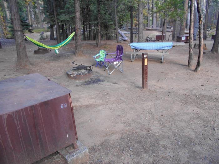
Tent Camping/ Trailer/RV Camping / Picnic Tables / Vault Toilets / Grills / Campfire Rings
Natural Features
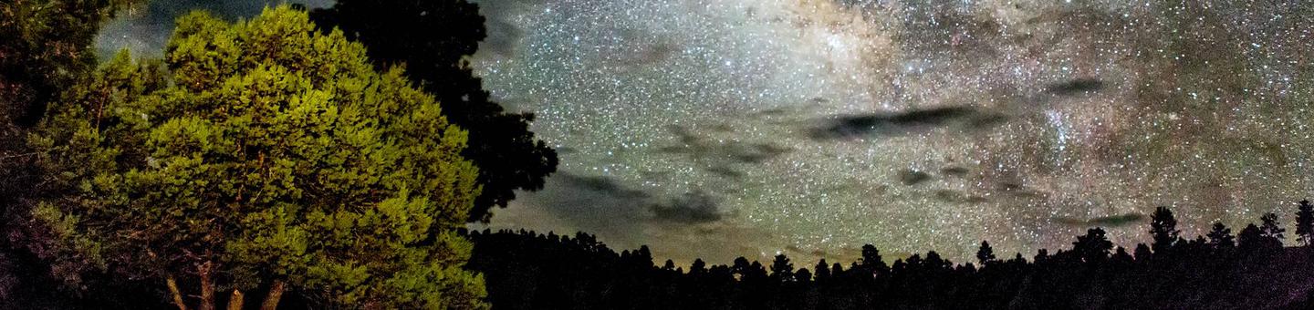
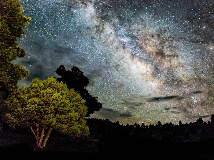
Forested / Unrestricted Night Sky Views
contact_info
For facility specific information, please call (575) 773-4678.Nearby Attractions
-El Caso I-3 Campgrounds
-El Caso 4 & 5 Campgrounds
-Juniper Campground
-Quemado Lake and Day Use Area
-Boat Ramp at Quemado Lake
Juniper Campground (Quemado Lake) Campground
List of CampsitesOverview
Juniper Campground is Quemado Ranger District's most popular campground. It offers electric RV hookups (no water, no sewer), leveled tent sites, and easy lake access. This campground is a mix of first come, first served sites and reservable sites. For more information, you can visit our website: https://www.fs.usda.gov/recarea/gila/recarea/?recid=1964
Recreation
Recreational opportunities include fishing and boating on Quemado Lake, hiking forest and lakeside trails, and RV and tent camping.
Facilities
Boat Ramp / Tent Camping/ Trailer/RV Camping / Picnic Tables / Vault Toilets / Grills / Campfire Rings
Natural Features
Lake Access/ Forested / Unrestricted Night Sky Views
Nearby Attractions
- El Caso I-3 Campgrounds
- El Caso 4 & 5 Campgrounds
- Piñon Campground
- Quemado Lake and Day Use Area
- Boat Ramp at Quemado Lake
contact_info
For facility specific information, please call (575) 773-4678.Charges & Cancellations
Cancellation Policy:
- A customer who cancels a reservation the day before or the day of arrival will pay a $10.00 service fee AND forfeit the first night's use fee (not to exceed the total paid for the original reservation). Cancellations for a one-night reservation will forfeit the entire amount paid and will not be subject to an additional service fee.
Gomez Peak (Group Picnic Site) Campground
List of CampsitesOverview
The Gomez Peak Large Group Area, just south of the main grounds, will accommodate up to 200 people, with parking for up to 50 vehicles. Facilities include large covered pavilion, 12 tables (seating for up to 96 people), pedestal BBQ grills, vault toilets, trash cans, volleyball and horseshoe pits.
As with all Little Walnut day use areas, no firewood is available. Plan to bring charcoal or wood for cooking as needed. Pets permitted on a leash only (remember to clean up after your pet). No horses allowed in the picnic grounds. Potable drinking water is available at the site.
Recreation
The popular Gomez Peak/Little Walnut Trail System can be accessed from the Gomez Peak Pavillion. Numerous loops of trails can be hiked from this location and is a popular attraction for mountain bikers and hikers alike.
Facilities
The Gomez Peak Group Use Area, just south of the main grounds, can accommodate up to 200 people, with parking for 50 vehicles. Facilities include covered pavilion with 12 tables (seating for up to 96 people, handicap accessible area), 2 large pedestal grills, vault toilets, trash cans, volleyball sand court & poles, and horseshoe pits. No firewood available.
Natural Features
The Gomez Peak Pavilion offers views of Gomez Peak and Eighty Mountain, and is surrounded by a Ponderosa and Pinyon-Juniper landscape. Deer, squirrels and a variety of birds can often be seen at the site.
Nearby Attractions
Little Walnut (Group Picnic Sites) Campground
List of CampsitesOverview
Located just outside Silver City, the Little Walnut-Gomez Peak picnic grounds provide a pleasant day use area for small or large groups and individuals/families. The area is generally open from 8:00 a.m. until sunset during spring, summer and fall; winter hours vary according to weather conditions.
The Little Walnut West Group Area can accommodate up to 50 people, with parking for 10 vehicles. Facilities include eight (8) tables, three (3) pedestal grills, vault toilets and trashcans.
The Little Walnut East Group Area can accommodate up to 75 people, with parking for 15 vehicles. Facilities include 10 tables, one (1) serving table, four (4) pedestal grills, vault toilets and trashcans.
For all group use areas, no firewood is available and camping is prohibited.
Recreation
The popular Gomez Peak/Little Walnut Trail System can be accessed from the Little Walnut Group Sites. Numerous loops of trails can be hiked from this location and is a popular attraction for mountain bikers and hikers alike.
Facilities
The Little Walnut West Group Area can accommodate up to 50 people, with parking for 10 vehicles. Facilities include eight (8) tables, three (3) pedestal grills, vault toilets and trashcans.
The Little Walnut East Group Area can accommodate up to 75 people, with parking for 15 vehicles. Facilities include 10 tables, one (1) serving table, four (4) pedestal grills, vault toilets and trashcans
Natural Features
The Little Walnut Group Sites offer views of Gomez Peak and is surrounded by a Ponderosa and Pinyon-Juniper landscape. Deer, squirrels and a variety of birds can often be seen at the site.
Lower Gallinas #795 Trailhead Facility
Trailhead for Lower Gallinas Trail #795.
McKnight #79 Trailhead Facility
Trailhead for accessing the Black Range Crest Trail #79.
Hinkle Park #36 Trailhead Facility
Trailhead for Camp Canyon Trail #36.
Bead Springs #138 Trailhead Facility
Trailhead for Bead Springs Trail #138.
Little Walnut Individual Picnic Area Facility
Little Walnut picnic grounds provide day use only for small or large groups and individuals/families. The area is generally open from 8:00 a.m. until sunset during spring, summer and fall; winter hours vary.
Middle Fork #157 Trailhead Facility
Trailhead in the Gila Cliff Dwellings area for Middle Fork Trail #157.
Dry Blue #61 Trailhead Facility
Trailhead for Dry Blue Trail #61.
Lake Roberts Picnic Area Facility
Located on the shores of Lake Roberts, off NM Hwy 35, approximately 21 miles north of Mimbres, NM.
Cox Canyon Trail #15/CDNST Trailhead Facility
Trailhead on Forest Road 94 - Cox Canyon Road for access to Divide Trail #15 and the Continental Divide National Scenic Trail #74 on the Gila National Forest.
Cottonwood #44 Trailhead Facility
Trailhead for Cottonwood Trail #44.
Allie Canyon #100 Trailhead Facility
Small parking area for Allie Canyon Trail #100 located along New Mexico Highway 35, just south of the Wilderness Ranger District office.
74 Mountain #153 Trailhead Facility
Trailhead for Mogollon Trail #153 and access into the southwestern portion of the Gila Wilderness. Nine (9) miles of this trail, from trailhead to junction with Trail Canyon Trail) was logged in the summer of 2017. This trail is a great access to the wilderness from Gila/Cliff region. It provides access to Mogollon Baldy. Mogollon Creek is still a lush place to hike despite some flooding.
Little Walnut West Group Area Facility
Little Walnut picnic grounds provide day use only for small or large groups and individuals/families. The area is generally open from 8:00 a.m. until sunset during spring, summer and fall; winter hours vary according to weather conditions.
Loco Mountain #143 Trailhead Facility
Trailhead for Loco Mountain Trail #143.
Little Dry #180 Trailhead Facility
Trailhead for Little Dry Trail #180.
Gila River #724 Trailhead Facility
Trailhead parking next to Grapevine Campground for access to the eastern end of Gila River Trail #724.
C Bar CDNST #74 Trailhead Facility
Trailhead for access to the Continental Divide National Scenic Trail #74 on the Gila National Forest
Gila Wilderness Facility
The 558,065-acre Gila Wilderness, created in June 1924 at the urging of the great conservation pioneer Aldo Leopold, was the world's first designated wilderness.
“The richest values of wilderness lie not in the days of Daniel Boone, nor even in the present, but rather in the future.” ~ Aldo Leopold
Alum Camp #788 Trailhead Facility
Trailhead for Alum Camp Trail #788.
Lake Roberts Facility
Lake Roberts is located in the Wilderness Ranger District along NM 35. It can be accessed via NM 35 or NM 15. NM 15 is a narrow paved, winding road that may not be suitable for trucks with trailers.
Log Canyon #808 Trailhead Facility
Trailhead for Log Canyon - Trail #808.
Little Whitewater #214 Trailhead Facility
Trailhead for Little Whitewater Trail #214.
Brannon Park #700 Trailhead Facility
Trailhead for Brannon Park Trail #700 located at Rocky Canyon Campground. This trail was logged summer 2017. The trail passes by Brannon Springs in a beautiful ponderosa forest with the nearby rock formations in Rocky Canyon.
Milligan Facility
The trail has a fantastic view of Negrito Creek
Iron Creek Campground Campground
List of CampsitesIron Creek Campground is easily accessible for campers and provides good facilities
Located in the Black Range Mountains off NM State Highway 152, starting at San Lorenzo and ending in Hillsboro. This is a mountain road with beautiful scenic sites at every curve. Watch for rocks on the road.
Quemado Lake Recreation Area Facility
Quemado Lake is located 16 miles south of Quemado, NM. From Quemado, take NM 32 south 14.2 miles to the Quemado Lake/NM 103 sign. At sign turn left onto NM 103 and go 4 miles to where Forest Road 13 (gravel) begins. Continue straight on FR 13 for 1 mile.
MeOwn #707 Trailhead Facility
Trailhead at MeOwn Work Center for MeOwn Trail #707.
Mineral Creek #201 Trailhead Facility
Trailhead for the western lower end of Mineral Creek Trail #201.
Lower Black Canyon #94 Trailhead Facility
Trailhead at the western end of Lower Black Canyon Campground to access Lower Black Canyon Trail #94.
Emory Pass #79 Trailhead Facility
Trailhead for access to the Black Range Crest Trail #79 across from the Emory Pass Observation Site on New Mexico Highway 152.
Whitewater Picnic Area Facility
The picnic area is open. This is a shaded picnic area located adjacent to Whitewater Creek.
Lake #110 Trailhead Facility
Trailhead for access to Lake Trail #110 Trail and Rattlesnake Trail #107.
Piñon Campground Campground
List of CampsitesThis is a nice, quiet and clean campground nestled among piñon and juniper trees.
The camp sites are nestled among mature piñon and juniper trees. It is tranquil and undiscovered with a few sites having a view of Quemado Lake. The campground is comprised of a family camping loop (east side) and a group camping loop (west side). The dump station is open and the fee is $5.
Gomez Peak Large Group Area Facility
For reservations, please contact the Silver City RD in person at 3005 E Camino del Bosque.
Click here to view a map of the Gomez Peak-Little Walnut Trail System
Frisco Box #762 Trailhead Facility
Trailhead for Frisco Box Trail #762.
Crosscountry Course #722 Trailhead Facility
Trailhead for Crosscountry Course Trail #722.
Gilita #157 Trailhead Facility
Trailhead in the Willow Creek area for Middle Fork Trail #157.
Blue Range Wilderness Facility
The 29,304 acre Blue Range Wilderness was designated in 1980 and is located on the western border of New Mexico and is managed by the Gila National Forest. It adjoins the Blue Range Primitive Area, which is managed by the Apache-Sitgreaves National Forests in Arizona.
Dragonfly Trailhead Facility
Trailhead for access to the Fort Bayard Trail System: Dragonfly - Trail #720, Servis Corrals - Trail #725, Old Highway 260 - Trail #260 and Crosscountry Course - Trail #722.
Flying V #706 Trailhead Facility
Trailhead for Flying V Trail #706 and access to the northern portion of the Gila Wilderness.
Crest #182 Trailhead Facility
Trailhead for Crest - Trail #182 at Sandy Point.
Catwalk #207 Trailhead Facility
Trailhead for the Catwalk National Recreation Trail #207 and Whitewater Trail #207.
Black Canyon Campground - Upper Campground
List of CampsitesBlack Canyon Campground offers a great remote camping experience.
Located in a remote area of the forest approximately 30 miles from the Wilderness Ranger District office. This campground is accessible from Forest Road 150 (North Star Road). The upper campground is the first camping area you will come across and is visible from the entrance road.
The forest recommends high-clearance 4x4 vehicles on Forest Road 150.
Aeroplane Mesa #705 Trailhead Facility
Trailhead for the Aeroplane Mesa - Trail #705 and access into the northern portion of the Gila Wilderness located at the Aeroplane Mesa Campground.
Continental Divide - CDNST Trailhead Facility
Trailhead for access to the Continental Divide National Scenic Trail #74 on the Gila National Forest.
Flying T #21 Trailhead Facility
Trailhead for Flying T Trail #21. The sign at the trailhead kiosk says "Pit Saddle Flying T Spring Trail."
Caledonia CDNST #74 Trailhead Facility
Trailhead for access to the Continental Divide National Scenic Trail #74 on the Gila National Forest
Board Gate Saddle #79 Trailhead Facility
Trailhead for access to the Black Range Crest Trail #79.
Snow Lake Facility
Snow Lake is a small reservoir located in the Reserve Ranger District approximatley 30 miles from the town of Reserve. Snow Lake is most easily accessed via FR 142.
Aspen Mountain #814 Trailhead Facility
Trailhead for Aspen Mountain Trail #814.
Middle Mesa #716 Trailhead Facility
Trailhead for Middle Mesa Trail #716.
Aldo Leopold Wilderness Facility
The United States Congress designated the Aldo Leopold Wilderness in 1980 and it has a total of 202,016 acres. All of the wilderness is in New Mexico and is managed by the Gila National Forest.
Deadman Canyon #786 Trailhead Facility
Trailhead for Deadman Canyon Trail #786.
Eagle Peak #768 Trailhead Facility
Trailhead for Eagle Peak Trail #768.
Circle Seven #106 Trailhead Facility
Trailhead for Circle Seven Trail #106.
Gomez Peak Trailhead Facility
Meadow #53 Trailhead Facility
Trailhead for Meadow Trail #53. Also referred to as Horse Camp Trailhead.
Deloche #179 Trailhead Facility
Trailhead for Deloche Trail #179.
Military Trail Trailhead Facility
Trailhead on the east side of New Mexico Highway 15, between mileposts 32 and 33, to access Military Road Trail 709 and Gila Flat Trail 97.
Forks Campground Campground
List of CampsitesThis campground features beautiful cliffs along the West Fork of the Gila River.
This campground is a great place to stop on the way to the Gila Cliff Dwellings National Monument (15 miles north). Overnight camping is allowed in the upper portion of Forks; however, the lower portion of the Forks Recreation Site along the West Fork of the Gila River is day use only.
Jack's Peak CDNST Trailhead Facility
Access to the Continental Divide National Scenic Trail (Trail #74 on the Gila National Forest) on the west side of New Mexico Highway 90 in the Burro Mountains near Jack's Peak.
Black Peak CDNST #74 Trailhead Facility
Trailhead for access to the Continental Divide National Scenic Trail #74 on the Gila National Forest.
CDNST/Mimbres Access #741 Trailhead Facility
Trailhead for the 4 mile long Continental Divide National Scenic Trail - Mimbres Access Trail #153 providing access to the Mimbres Trail #77 (roughly 0.6 miles to Trail #77) and the Continental Divide National Scenic Trail (roughly 4 miles travel).
Continental Divide #74 Trailhead Facility
Trailhead for access to the Continental Divide National Scenic Trail #74 on the Gila National Forest.
Black Canyon Campground - Lower Campground
List of CampsitesThis is a beautiful remote camping area. Trail #94 begins at the rear of the campground.
Located in a remote area of forest approximately 30 miles from the Wilderness Ranger District office. This campground is accessible from FR 150, and driving approximately .5 miles from the road, across the stream. You will enter an area with a newer vault toilet and a beautiful meadow next to the stream.
Please be advised - the district recommends high-clearance 4x4 vehicles on FR 150.
Bird Sanctuary #745 Trailhead Facility
Trailhead for Bird Sanctuary Trail #745 at the Gila River Bird Sanctuary.
County B-054 CDNST Trailhead Facility
Trailhead on County Road B-054 (Bursum Rd.) to access the Continental Divide National Scenic Trail.
Gold Dust #41 Trailhead Facility
Trailhead for Gold Dust - Trail #41. Hwy 180 to Bursum Road (NM Hwy 159). There is a trail sign on your left and a pull-out at the trailhead on the right. The hike off Whitewater Mesa to Whitewater Creek is approximately 2.5 miles. The hike along the creek is unavailable due to closure between Gold Dust and the upper Catwalk National Trail.
Diamond Creek #40 Trailhead Facility
Trailhead for Diamond Creek Trail #40 and access into the western portion of the Aldo Leopold Wilderness.
McKnight Cabin #92 Trailhead Facility
Trailhead for accessing the lower end of the McKnight Cabin Trail #92.
Largo #14 Trailhead Facility
Trailhead located near El Caso Campground at Quemado Lake for Largo Canyon - Trail #14.
Lookout Mountain CDNST Trailhead Facility
Parking area on Forest Road 226A Lookout Mountain Rd. to access the Continental Divide National Scenic Trail (Trail #74 on the Gila National Forest).
Little Walnut-Gomez Peak Day Use Area Facility
Located just outside Silver City, the Little Walnut-Gomez Peak picnic grounds provide a pleasant day use area for small or large groups and individuals/families. The area is generally open from 8:00 a.m. until sunset during spring, summer and fall; winter hours vary according to weather conditions.
The Silver City Ranger District offers three reservable large group picnic areas within the Gomez Peak – Little Walnut day use area, as well as individual picnic sites. All areas have vault toilets, picnic grills, and tables. In addition, the largest area also offers added amenities of a covered shelter, volleyball court, and horseshoe pits.
Please NOTE: Water is not available at the group or family picnic areas at Little Walnut.
View a detailed Recreation Opportunity Guide
View a Little Walnut Trail System Map
For information on the picnic areas, see: Little Walnut (East, West, Individual/Family) or Gomez Peak Large Group Area.
Kingston Campground Campground
List of CampsitesSmall campground located along the north side of New Mexico Highway 152, near mile marker 40, near Middle Percha Creek, on the eastern edge of the small town of Kingston, NM.
Govina Canyon CDNST Facility
Access at the end of Forest Road 3077 Govina Canyon Rd. to the Continental Divide National Scenic Trail (Trail #74 on the Gila National Forest).
Ladrone #127 Trailhead Facility
Trailhead for Ladrone Gulch Trail #127.
Big Tree #755 Trailhead Facility
Trailhead for Big Tree Trail #755.
The Big Tree is a popular destination point for many local and out of town visitors to the historic Fort Bayard Military Reserve. The Big Juniper Tree is nationally ranked as the second largest alligator juniper tree in the United States (American Forests 1980, “National Register of Big Trees.” American Forestry Association, Washington, D.C.). The tree diameter is 70.2 inches. Its circumference is 18 feet 4 inches; its crown spread is 62 feet wide; and its height is 63 feet. The trail length and gentle nature of the route leading to the Big Tree make it a pleasing choice. The route follows primitive roads that pass through the rolling foothills of the Pinos Altos Mountains. Key vista points along the trail provide impressive views of the Twin Sisters and the Kneeling Nun.
During the 1960’s, Fort Bayard was an active military post housing soldiers (including Buffalo Soldiers) who provided protection to the local mining settlements of Pinos Altos and Santa Rita. The route to the Big Juniper Tree is an old wagon road that provided access to the Pinos Altos Mountains. Rough cut lumber and fuel wood were transported down to the fort via these roads and hauled on horse and mule powered wagons.
Current management of the Fort Bayard area emphasize wildlife, watershed protection and recreational activities. Trail users often see glimpses of wildlife including the resident elk herd that frequent the Fort Bayard area.
Little Walnut East Group Area Facility
Little Walnut picnic grounds provide day use only for small or large groups and individuals/families. The area is generally open from 8:00 a.m. until sunset during spring, summer and fall; winter hours vary according to weather conditions.
East Canyon #93 Trailhead Facility
Trailhead for East Canyon Trail #93 and Quaking Aspen Trail #86.
Quemado North End (CDNST) Trailhead Facility
Northernmost trailhead on the Gila National Forest for access to the Continental Divide National Scenic Trail (Trail #74 on the Gila National Forest).
San Francisco Hot Springs #250 Trailhead Facility
Trailhead on the west side of US Highway 180, south of Glenwood, NM between mile markers 58 and 59, for San Francisco Hot Springs Trail #250.
Purgatory Chasm #779 Trailhead Facility
Trailhead for Purgatory Chasm Trail #779 loop.
Sheridan Corral #181 Trailhead Facility
Trailhead for the southern end of Holt-Apache Trail #181.
Redstone #206 Trailhead Facility
Trailhead for Redstone - Trail #206.
Pictograph Nature Trail #800 Trailhead Facility
Trailhead for Pictograph Nature Trail Trail #800 (also referred to as Spirit Canyon Trail).
Sapillo Trailhead/CDNST Facility
Trailhead at Sapillo Group Campground for access to the Continental Divide National Scenic Trail (Trail #74 on the Gila National Forest).
Powerhouse #810 Trailhead Facility
Trailhead for Powerhouse - Trail #810.
South Diamond #68 Trailhead Facility
Trailhead for South Diamond Trail #68 and access to the western portion of the Aldo Leopold Wilderness. 12 miles of the trail was logged summer 2017.
The trail up South Diamond to Diamond Peak is not burned and is a beautiful place to hike and camp along a stream. It passes through a wide variety of forest types such as pinyon/juniper, ponderosa, mixed confier, and aspen.
Rocky Point CDNST Trailhead Facility
Trailhead located along Forest Road 150 (North Star Rd.) roughly 2.5 miles north of Rocky Canyon Campground to access the Continental Divide National Scenic Trail (Trail #74 on the Gila National Forest).
Pueblo Park #515 Trailhead Facility
Trailhead at the Pueblo Park Campground for access to the southern end of Dangerous Park Trail #515 and the Pueblo Park Interpretive Loop Trail #5151.
Pretty Canyon #121 Trailhead Facility
Trailhead for Pretty Canyon Trail #121. This trailhead is a small pullout parking spot along Forest Road 152 (McKnight Rd.) across from the start of the Pretty Canyon Trail. McKnight - #79 Black Range Crest Trailhead, just 0.3 mile further down the McKnight Rd. has much more parking space.
Rainy Mesa #15 Trailhead Facility
Trailhead for Continental Divide National Scenic Trail, Trail #15.
Redrock Rd. CDNST Trailhead Facility
Trailhead located in the Burro Mountains along Redrock Road to access the Continental Divide National Scenic Trail (Trail #74 on the Gila National Forest).
Sheep Corral #231 Trailhead Facility
Trailhead for access to Sheep Corral Canyon - Trail #231, heading north towards the Gila River and Wilderness, and Tadpole Ridge - Trail #232, heading south towards the Signal Peak Trailhead on New Mexico Highway 15.
North Fork Mineral Creek #201 Trailhead Facility
Trailhead for North Fork Mineral Creek Trail #201.
Rabb Park #747 Trailhead Facility
Trailhead for Rabb Park Trail #747.
Signal Peak #742 Trailhead Facility
Trailhead on the west side of New Mexico Highway 15, between mile markers 14 and 15, for Signal Peak Trail #742 (across the road from the trailhead) and for Tadpole Ridge Trail #232 heading north towards the Sheep Corral Trailhead.
Tom Moore #708 Trailhead Facility
Trailhead for Tom Moore Trail #708. Six (6) miles of this trail, from FR 150 to the junction with Trail #716 and #713, was logged summer 2017. The trails gently winds through a wide and open canyon of lovely old ponderosa trees. It also passes by a spring-fed tank.
Turkey Run #42 Trailhead Facility
Trailhead for Caledonia Trail #42 and access to the northern portion of the Aldo Leopold Wilderness. .75 miles of this trail was logged in the summer of 2017. The beginning of the trail is a moderate incline through ponderosa forests to a saddle. As the trail drops down to Diamond Creek, it passes a waterfall and interesting rock formaitons. The trail will arrive at Diamond Creek which supports a lush mixed confier forest ecosystem.
Turkey Creek #724 Trailhead Facility
Trailhead for access to the western end of Gila River Trail #724, as well as access to Turkey Creek Trail #155.
TJ Corral #729 Trailhead Facility
Trailhead near the Gila Cliff Dwellings for Little Bear Trail #729, also providing access to the southeast end of West Fork Trail #151.
Trails End #804 Trailhead Facility
Trailhead for Adobe Springs Trail #804.
Snow Lake #142 Trailhead Facility
Trailhead at Snow Lake for Snow Lake Trail #142.
Snow Creek #233 Trailhead Facility
Trailhead for Snow Creek Trail #233. The trailhead sign, roughly 3.8 miles down Forest Road 282 Sheep Corral Rd., says "Forest Trail."
Wagon Wheel - CDNST Trailhead Facility
Trailhead on Little Walnut Road, north of the Little Walnut-Gomez Peak Day Use Area, for access to the Continental Divide National Scenic Trail (Trail #74 on the Gila National Forest).
Walk in the Past #616 Trailhead Facility
Trailhead for Walk in the Past Trail #616.
West Fork #151A Trailhead Facility
Trailhead at the Gila Cliff Dwellings National Monument parking lot for West Fork Shortcut Trail #151A used for hiker access to the West Fork Trail #151 and also EE Canyon Trail #163.
Whitetail Canyon #202 Trailhead Facility
Trailhead at Sandy Point for Whitetail Canyon - Trail #202.
Wolf Hollow #773 Trailhead Facility
Trailhead at Wolf Hollow Campground for Wolf Hollow Trail #773 to Black Mountain. Five (5) miles of Wolf Hollow Trail #773 was logged, from FR 141 to Black Mountain Lookout, in the summer of 2017.
This is a good day hike to see the views from Black Mountain.
Woodhaul Wagon Road #55 Trailhead Facility
Trailhead at Fort Bayard for access to the Woodhaul Wagon Road Trail #55 and the Fort Bayard Trail System.
Willow Creek #151 Trailhead Facility
Trailhead at Willow Creek Recreation Area for West Fork Gila River Trail #151.
Woody's Corral #160 Trailhead Facility
Trailhead at Woody's Corral near the Gila Cliff Dwellings for Granny Mountain - Trail #160 and access to the Gila Wilderness.
WS Mountain #43 Trailhead Facility
Trailhead across from Pueblo Park Campground for W.S. Mountain Trail #43 and access to the Blue Range Wilderness.
Upper Frisco Hot Springs #124 Trailhead Facility
Trailhead for Frisco Divide Trail #124.
Tularosa Cabin Facility
Historic cabin located along the Walk In The Past - Trail #616 Interpretive Trail.
Senator Clinton P. Anderson Overlook Facility
Interpretive exhibit and overlook of the Gila Wilderness on the west side of NM Highway 15 at mile marker 32.
Emory Pass Observation Site Facility
Observation point at Emory Pass on the north side of New Mexico Highway 52, between mile markers 31 and 32. The observation site also serves as a parking area for access to the Black Range Crest Trail #79 and Scenic Trail #796.
Monument Park Cabin Facility
Historic cabin located at Monument Park along Forest Road 226.
Forest Boundary Kiosk Facility
Rest area and information kiosk at the eastern boundary of the Gila National Forest on New Mexico Highway 59, between mile markers 2 and 3.
Arrastra Interpretive Site Facility
Arrastra Interpretive Site, on the Silver City RD, is located adjacent to NM Hwy 15. The arrastra was a primitive crusher/mill used in old time mining operations. It was horse/mule powered and used the action of grindstones to process the rock extracted from gold mining. The interpretive site has a reproduction of the original arrastra and a couple of interpretive panels that identify the location of the gold mine at that site as well as explaining the arrastra and the process used to separate the ore from the rock.
There is parking and a short path to the arrastra. There are a handful of signs and a couple of stone benches. It is a day-use only site. Parking area also provides access to the Continental Divide National Scenic Trail (Trail #74) on the Gila National Forest. No fees, restrooms or water.
Gila Center Facility
Interagency visitor center managed by the National Park Service and Gila National Forest providing information regarding the Cliff Dwellings National Monument and Gila Wilderness.
Quemado Lake Boat Launch Facility
Small boat launch located at the western end of Quemado Lake for non-motorized boats and boats with electric motors.
Snow Lake Boat Launch Facility
Small boat launch for non-motorized boats and boats with electric motors at Snow Lake near Dipping Vat Campground.
Lake Roberts Boat Launch Facility
Small boat launch at Lake Roberts for non-motorized boats and boats with electric motors.
South Fork Mineral Creek #798 Trailhead Facility
Trailhead for South Fork Mineral Creek Trail #798. First two (2) miles were logged summer 2017.
Mogollon Box Day Use Area Facility
Day use area at the confluence of the Gila River and Mogollon Creek.
El Caso I-IV Campground Campground
List of CampsitesThis are partially developed, shady campgrounds within hiking distance of the lake.
The El Caso Campgounds are partially developed campgrounds located at the east end of Quemado Lake, approximately .25 miles east of the Piñon CG. They are nestled in a valley stretching alongside an intermittent stream and are surrounded by ponderosa pine and cottonwood trees. The El Caso Campgrounds are popular with hunters, groups, and campers desiring a more primitive camping experience.
Railroad Canyon #96 Trailhead Facility
Trailhead located on the north side of New Mexico Highway 35, between mile markers 21 and 22 - also between Sapillo Group Campground and Lake Roberts, for Railroad Canyon Trail #96.
