
Lincoln National Forest
Welcome to the Lincoln's Recreation page.

General Questions about Recreating on the Lincoln?
Call your local Ranger Station and check on temperatures, conditions, best place to go for your wishes and much more.
Download Geo-PDF's of popular trail areas for use in your phones: Click Here
RecAreaDirections
Open with Google Map
Misc
| Stay Limit | |
| Reservable | false |
| Keywords | |
| Map Link | |
| Contact Phone | |
| Contact Email |
Permits info
Facilities
Aspen Group Area (Lincoln National Forest, NM) Campground
List of CampsitesOverview
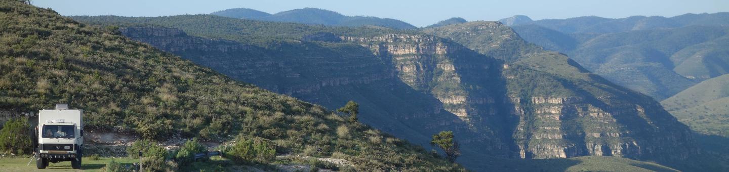
At an elevation of almost 9,000 ft., campers at the Aspen Group Area can expect cool, crisp, mountain breezes coming off the steep Sacramento Mountains - perfect for an escape from the scorching desert valley below. The campground is surrounded by mixed pine, fir, and plenty of white-trunked aspen trees, with a high likelihood of blue skies above.The Sacramento Mountains overlook Dog Canyon and the Tularosa Basin. Take advantage of the campground's high elevation and revel in the breathtaking beauty of the region's unspoiled vistas stretching out over the Tularosa Basin. Wildlife in the area includes elk, deer, bears. With some luck, you could even spot a roadrunner.
Recreation
The campground is surrounded by a series of hiking trails. To the west you'll find trails with outstanding overlooks from Alamo Peak and Stark Peak. The most popular hike is the Osha Trail, which is a 2.5-mile loop.Facilities
Water can be obtained at Deerhead Campground during peak season, which lasts from Memorial Day to Labor Day. The site is available as a group site only, so groups of anywhere from four to 70 can reserve the whole space.Natural Features
Aspen is set in the rolling Sacramento Mountains of south-central New Mexico, near Alamo Peak and Stark Peak. It's part of Lincoln National Forest, most notable as the birthplace of the original Smokey Bear.Nearby Attractions
The Rim Trail, a breathtaking 32-mile path for mountain biking, hiking, and horseback riding, can be reached a quarter mile from the campground. One stretch of the trail is open to motorcyclists, too. The Oliver Lee Memorial State Park, at the foot of the mountains, is worth a visit to see a restored 19th century ranch house and explore the flowering oasis of Dog Canyon.BLACK BEAR GROUP AREA Campground
List of CampsitesOverview
Black Bear is perched atop the scenic Sacramento Mountains of south-central New Mexico, near Alamogordo and Cloudcroft. The site is surrounded by the aromatic pine trees and aspen groves of Lincoln National Forest. The group area is conveniently connected to a network of hiking and biking trails. Bring your camera and binoculars for the chance to spot elk, deers, birds, and even black bear.The black bears are arguably the most celebrated wildlife in the area due to the fact that the original Smokey Bear was found here. While battling a fire in 1950, firefighters rescued a burned bear cub clinging to a scorched tree in Lincoln National Forest. The bear was adopted by the US Forest Service and became the real-life mascot for forest fire prevention.
Recreation
Evening skies are often clear of clouds - bring a telescope for stargazing. The campground is surrounded by a series of hiking trails. A popular hike is the Osha Trail, which is a 2.5-mile loop.Facilities
Whether for a family reunion or a large social event, Black Bear is a convenient location for groups up to 70. No water is provided at this site, but it is available at Deerhead Campground from Memorial Day to Labor Day.Natural Features
Set 9,000 feet above sea level in the Sacramento Mountains, Black Bear is in a pine forest area overlooking the desert valley of the Tularosa Basin. The basin stretches 6,500 square miles between the Sacramentos and the San Andres Mountains.Nearby Attractions
The campground is a mile from Cloudcroft, a quaint tourist village with New Mexico's only standing railroad trestle. It's also a quarter mile from the Rim Trail, which is popular for mountain biking, hiking, and horseback riding. Other nearby trails are open to ATV enthusiasts.UPPER FIR GROUP AREA Campground
List of CampsitesOverview
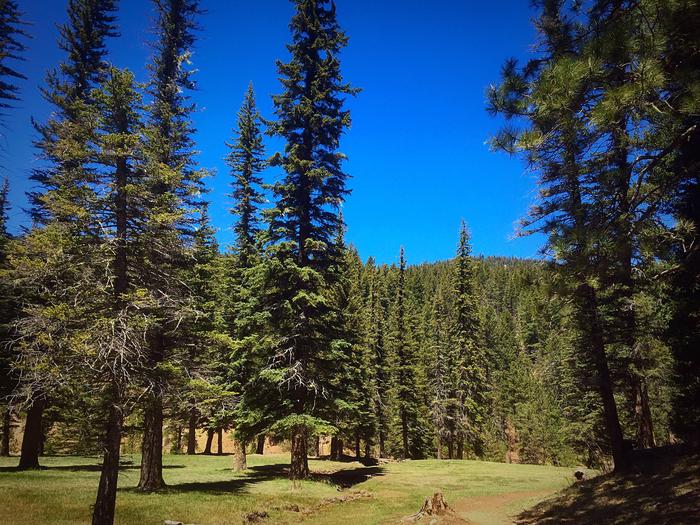
Upper Fir Group Area is one of the most popular campsites in the Sacramento Mountain area. Unique to its neighboring campgrounds, it's set far back from public roads, allowing for true peace and quiet.The campground is on the northwestern portion of the Lincoln National Forest, a protected area spanning an incredible 1.1 million acres of land. Spend your days exploring the mountains, or head west for a day trip to explore White Sands National Monument, the world's largest dune field of pure, white gypsum sand.
Recreation
An open meadow, perfect for sports like ultimate Frisbee or horseshoes, is connected to the campground. The Rim Trail is a short hike or drive away, offering epic views, rocky inclines, and switchbacks for adventurous mountain bikers, hikers, and horse-back riders. Further down, the same trail opens up to motorcyclists as well.Facilities
This is one of the only group sites with water access. Upper Fir comfortably fits groups as large as 120, and it's connected to Lower Fir Group if your party has a need for an additional group of up to 70 campers.Natural Features
Set 9,000 feet above sea level in the Sacramento Mountains, Upper Fir Group Area is close to breathtaking scenic overlooks, spanning the far-reaching desert valley of the Tularosa Basin. The high-elevation region offers a mixture of pine, fir, aspen, and oak trees, with high mountain meadows full of wildflowers and blossoming plants.Nearby Attractions
The campground is a mile from the town of Cloudcroft, a quaint tourist village with New Mexico's only standing railroad trestle.SLIDE GROUP AREA Campground
List of CampsitesOverview
Just two miles from the village of Cloudcroft is this idyllic campground accommodating groups up to 90 visitors. Take advantage of the views of the Tularosa Basin or bask in the sun on the wildflower-dusted mountain meadow. A network of trails surround the campground, where you can look for deer, elk, and many types of birds. The region is part of the 1.1 million acres of Lincoln National Forest, where the original Smokey Bear was rescued as a cub from a forest fire.There's no shortage of beauty in the area, with expansive blue skies, clear nights for stargazing, and hikes to several peaks and overlooks. Attractions in the vicinity include White Sands National Monument, the Oliver Lee Memorial State Park, and the Sunspot Museum - home to the national solar observatory.
Recreation
Slide Group Area backs into the Rim Trail, offering epic views, rocky hills, and switchbacks. Head north on the trail for mountain biking, hiking, and horse-back riding. Head south for the part of the trail that allows motorcycles. An open meadow, perfect for sports like volleyball, corn hole, or football, is connected to the campsite.Facilities
The picturesque overlook and convenient road access are unique, convenient features of this group site. Parking can accommodate approximately 12 trailers or 50 automobiles.Natural Features
The campground is located on the rim of the Sacramento Mountains with a view of the Tularosa Basin. Mixed evergreen and aspens surround the 9,000 ft. elevation site.Nearby Attractions
Drive along the Sunspot Scenic Byway to catch phenomenal views of the Tularosa Basin, White Sands National Monument, and colorful desert sunsets. Cloudcroft, a quaint mountain village nearby, is also worth a visit.LOWER FIR GROUP AREA Campground
List of CampsitesOverview
Lower Fir Group Area is a high-energy and highly popular group campground in the Sacramento Mountain area. The site is set away from public roads, so that outside noise is non-existent, leaving only the sweet sounds of rustling aspen leaves.The campground sits within the Lincoln National Forest, which spans 1.1 million acres of undisturbed landscape. Spend your days exploring the mountain trails, or head west for a day trip to White Sands National Monument, the world's largest dune field of pure, white gypsum sand. Bring your camera and binoculars for the chance to observe wild elk, deer, birds, and even an occasional black bear.
Recreation
An open meadow, ideal for activities like volleyball or horseshoes, is adjacent to the campground. The Rim Trail is a short hike or drive away, offering epic views, rocky inclines, and switchbacks for adventurous mountain bikers, hikers, and horse-back riders. A few miles south, the same trail opens up to motorcyclists as well.Facilities
This is one of the only group sites with water access. Lower Fir comfortably fits groups as large as 70, and it's connected to Upper Fir Group, and even larger facility accommodating up to 120 visitors.Natural Features
Lower Fir Group sits at a high elevation of 9,000 ft., providing visitors with dramatic views of the Tularosa Basin and lush mountain meadows surrounded by pine, fir, aspen and oak trees.Nearby Attractions
The campground is a mile from the village of Cloudcroft, a quaint mountain town with New Mexico's only standing railroad trestle. Trails for ATVs are near the area, too.CEDAR CREEK (Sam Tobias) Campground
List of CampsitesOverview
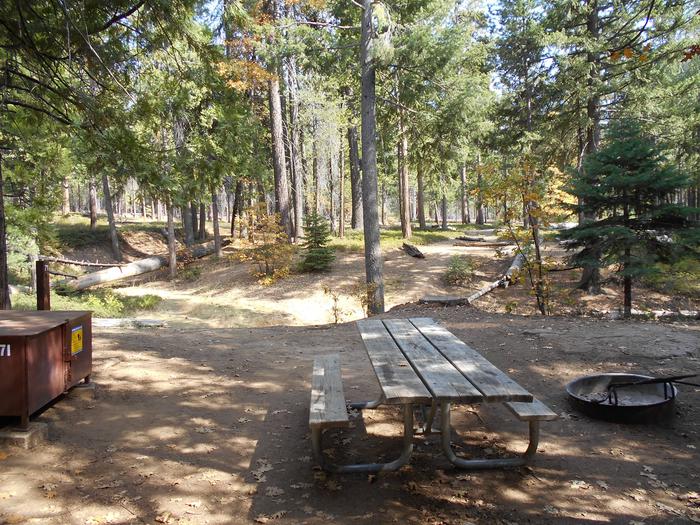
Located on the outskirts of Ruidoso, Cedar Creek provides a wonderful space for groups visiting for the day or staying overnight. With a picnic shelter and three group campsites, the recreation area is ideal for an outing in Lincoln National Forest. A popular pastime is is hiking and mountain biking along the scenic multi-use trails adjacent to the Sam Tobias Memorial Group Campground. There are opporunities to see a number of different wildlife, including Mule deer and Elk in the area.Recreation
Hiking and biking are among the most popular activities here, with options like the T90 fitness Trail which extends 1.3 miles and includes exercise stations. Bilking trails T120 A-D and T121 A& B are also nearby. Also we have an expert-only downhill mountain bike trail, located near the water tower to the east of the Campgrounds. The trail ends at the picnic area. Dogs must be kept on leash at all times while hiking. Dogs are not allowed on the Fitness trail.Facilities
The group picnic shelter offers drinking water and accessible vault toilets. Non-sheltered picnic tables are open to the general public.The group campgrounds range from 60 to 100 person capacities and the group picnic shelter fits up to 40 people. Each site comes with accessible picnic shelters, campfire rings, drinking water vault toilets and grills.
Picnic Pavilion is for day use only. If you would like to camp overnight please book one of the group campgrounds.
Natural Features
Cedar Creek is perched along its namesake, Cedar Creek at a 7,000 foot elevation. Lincoln National Forest, located in south-central New Mexico, is most notable as the birthplace of the original Smokey Bear.Nearby Attractions
Ruidoso is a delightful town with quaint shops, restaurants and art galleries. If picnickers wish to camp overnight, they can head to Sam Tobias Memorial Group Campground.White Mountain Wilderness Facility
The White Mountain Wilderness is located about 10 miles NW of the Village of Ruidoso, NM.
Sacramento RD Facility
The Sacramento Ranger District offers many different recreation opportunities for all seasons.
Scenic Viewing
Winter Sports
Picnicking
Group Picnicking
Camping
Group Camping
Dispersed or "road-side" camping:
You may drive to park your RV no more than 300' from an open road designated for such use. Please check with one of our offices to obtain a free Motor Vehicle Use Map which details exactly what roads you are allowed to disperse camp along. Most roads, outside of US and State Highways are available for this use. Please be mindful that there are many private land inholdings within the Forest and these lands are not available for camping.
Trails:
We offer trails ranging in use from hiking, pack/saddle, mountain biking, motorcycle riding and ATV riding (less than 50" in width). Most side-by-sides are greater than 50" in width and exceed a weight limit, these can be enjoyed on our dirt roads.
There is little to no water available in many places so please bring what you need and be safe.
Smokey Bear RD Facility
The Smokey Bear Ranger District offers many different recreation opportunities for all seasons.
Winter Sports
Scenic Viewing
Picnicking
Group Picnicking
Camping
Group Camping
Dispersed or "road-side" camping:
You may drive to park your RV no more than 300' from an open road designated for such use. Please check with one of our offices to obtain a free Motor Vehicle Use Map which details exactly what roads you are allowed to disperse camp along. Most roads, outside of US and State Highways are available for this use. Please be mindful that there are many private land inholdings within the Forest and these lands are not available for camping.
Trails:
We offer trails ranging in use from hiking, pack/saddle, mountain biking, motorcycle riding and ATV riding (less than 50" in width). Most side-by-sides are greater than 50" in width and exceed a weight limit, these can be enjoyed on our dirt roads. Most of the trails within this district reside within the White Mountain and Capitan Wilderness Areas, so for a motorized Off Highway Vehicle experience, there are a handful of trails but nearly all of our dirt roads are available for use.
There is little to no water available in many places so please bring what you need and be safe.
Guadalupe RD Facility
The Guadalupe Ranger District offers many recreation opportunities for you to enjoy.
Picnicking: One developed picnic site, Sitting Bull Falls, is available for your use.
Camping: Dispersed ("road-side") camping only.
Dispersed or "road-side" camping: You may drive to park your RV no more than 300' from an open road designated for such use. Please check with one of our offices to obtain a free Motor Vehicle Use Map which details exactly what roads you are allowed to disperse camp along. Most roads, outside of US and State Highways are available for this use. Please be mindful that there are many private land inholdings within the Forest and these lands are not available for camping.
Trails: Currently, all of the trails within the Guadalupe Ranger District allow only pedestrian or pack/animal traffic. No mechanized (mountain bikes) nor motorized vehicles are allowed on our trails. However, these activities are permitted on the roads in the district.
The district is remote with little to no water available so please bring what you need and be safe.
Nelson Canyon Vista Interpretive Site Facility
The Nelson Canyon Vista and trail offers a quick little hike from NM6563 to a beautiful vista (view) of the Tularosa Basin below.
Dark Canyon Lookout Observation Site Facility
Dark Canyon, the only lookout located on the Guadalupe Ranger District, is an Aermotor MC-99 type 7’ X 7’ cab sitting on a 48 foot high steel tower. Erected in 1949, it is one of only two MC-99 types still standing in the southwestern Region (the other is on the Kaibab National Forest). The Dark Canyon site has been used for fire detection since 1910, utilizing two tall pine trees with ladders and platforms, until replaced by a steel lookout in the late 1930s. This tower was condemned within a year, and the use of the lookout trees was resumed. Dark Canyon’s second steel lookout was surplused from the U.S. Army and erected on the site in 1949. The original tower height was 90 feet tall, but only the last 48 feet were ultimately used. Next to the lookout are an Observer’s cabin and shed; both are wood frame constructions that were built by the Civilian Conservation Corps (CCC) in the late 1930s. Dark Canyon Lookout was not eligible for the National Register when the 1989 nomination of lookouts in the Southwestern Region was made. Dark Canyon became eligible in 1999 and will soon be nominated.
Haynes Canyon Vista Observation Site Facility
Located along the Sunspot Scenic By-way (NM6563) just about 1mile south of the beginning of the road, this Vista (view) offers stunning views of Hayne's Canyon below in High Rolls and beyond to the Tularosa Basin.
Trestle Vista Observation Site - south Facility
From 1899-1947, the steam engines of old used to climb the railroad line from Alamogordo to Cloudcroft and beyond. The Mexican Canyon Trestle observation site offers a stunning view of one of the last standing large trestles along the route.
Sleepy Grass Picnic Area Facility
Located about 1 mile east of the Village of Cloudcroft just off Highway 82.
Four picnic sites available for use.
Mexican Canyon Trestle Vista US82 Facility
This vista, located just NW of the Village of Cloudcroft, offers a majestic view of the 1899 railroad trestle called the Mexican Canyon Trestle via US82.
Windy Point Vista Facility
Soaring to nearly 10,000' high, the Windy Point Vista is a spectacular vantage point of the entire Lincoln National Forest and Tularosa Basin. The vista is located about 1 mile before you reach the Ski Apache downhill ski area.
Although the road is paved, there are many tight turns. It is not for the feint of heart if you have a fear of heights. The journey takes about 30 minutes from the Village of Ruidoso.
Capitan Wilderness Facility
The Capitan Wilderness Area lies about 5 miles NE of Capitan, NM and is most famous as the place where the real Smokey Bear was found in 1950.
Haynes Canyon Vista Facility
Located about 1 mile south of the NM6563 and NM130 turnoff, this viewing area (vista in spanish) makes for a wonderful photo opportunity.
5 Points Vista Facility
Located in the far SW portion of the Guadalupe Ranger District, this viewing area (vista) offers spectacular views of the 'Rim' and the Guadalupe Mountains. The Rim is nearly a 1500' - 2000' cliff marking the western extent of the Guadalupe Mountains. It extends the entire north-south length of the ranger district and extends into National Park land at its south end.
Take US285 north of Carlsabad and turn west onto NM137. Continue to Queen, NM and turn left onto Forest Road 540 and follow this road for about 3 miles. There are vistas all along this area with convenient turn around points.
Be sure to come prepared with a full tank of gas and water, the area is remote but a good day drive.
Mayhill Lookout Facility
The Mayhill Lookout was moved in 1967 to James Ridge, and is now known as the James Ridge Lookout. The Mayhill Lookout was constructed in 1935, and was part of the Mayhill Civilian Conservation Corps (CCC) camp F-24-N which constructed permanent buildings in 1934. The Mayhill Lookout was an LX-24 cab sitting on a 48 foot tower. As seen in the photograph, the site include the Observer’s cabin which was the standard CCC constructed type.
Wofford Lookout Facility
Wofford lookout has a seven foot square Aermotor MC-39 steel cab that sits on an eighty foot high tower. It was erected by the Civilian Conservation Corps (CCC) in 1933. At the base of the tower sits the observer’s cabin which is a wood framed structure also built in 1933 by the CCC. The cabin measures 12’ X 16’ and has a gable roof, and narrow wood slats for siding. The storage shed, constructed in 1937 measures 7’ X 10’ and is also a wood frame structure. Both the cabin and shed were restored in 2012 in preparation for use as a cabin rental which is soon to open for public use.
Access to the tower site is by foot traffic only with access to the tower itself being closed to the public.
James Ridge Lookout Facility
Located on the Sacramento Ranger District, James Ridge Lookout (formerly Mayhill Lookout), is a 7’ X 7’ steel cab sitting on a 62 foot high steel tower. The cab style is designated as and Aermotor LX-24; however, the lookout has been extensively remodeled since it was moved from its previous Mayhill site. The lookout was moved to James Ridge in 1967, and its future eligibility to the National Register of Historic Places will be based upon that date.
Alamo Lookout Facility
Alamo Lookout was an Aermotor LX-25 type 7’ X 7’ cab sitting on a 35 foot high tower. Like the Weed Lookout, the Alamo Lookout was erected in 1926 and had a wood framed Observer’s cabin of CCC construction (date unknown). The site is now occupied by a US Air Force telemetry antenna. The only remaining indication of the Alamo Lookout is its bench mark.
Carrissa Lookout Facility
The Carrisa Lookout complex contains the lookout, Observer’s cabin, shed and outhouse. This 7’ X 7’ Aermotor MC-39 cab sits upon an 80 foot high steel tower erected in 1934. Carrisa’s Observers cabin and shed were constructed in 1935 by the Civilian Conservation Corps. The site’s structures were restored in 2012, and will be considered for future rental program. The Carrisa Lookout Complex is listed on the National Register of Historic Places (NRHP).
The road to the lookout is gated and closed but access to the area by foot is possible. This site is being converted soon to a cabin rental site, so stay tuned.
Monjeau Lookout Facility
Monjeau Lookout is a famous landmark on the Smokey Bear Ranger District built originally in 1936 and then reconstructed in 1940 as part of a Civilian Conservation Corps project. This site is a wonderful and adventurous place to visit. Roads leading up to the site are dirt and can be steep in places. Visit during the summer months as the road leading to it closes during the winter with the advent of snow. Monjeau Lookout is listed on the National Register of Historic Places (NRHP).
Click Here for a recent article from the "Lookout Network" detailing the entire history of this place.
Cedar Creek Picnic Shelter Facility
The Picnic Shelter at Cedar Creek may be reserved for group use for up to 40 people. Day-use only. Picnic Tables, water, grills and a cover for weather and shade are available via www.recreation.gov for $25 a day.
Sacramento Lookout Facility
Sacramento Lookout, a CL-100 series built in 1968 for the US Forest Service, is located on the Sacramento Ranger District. Sacramento is a 14’ X 14’ live in cab sitting on a 62 foot high steel tower. The Sacramento Lookout on a clear day, affords a grand view all the way into Mexico. Sacramento Lookout will become eligible for the National Register in 2018.
Ruidoso Lookout Facility
This lookout, a 30 foot high steel tower with a wooden cab 14 feet square, is an Aermotor MI-25 type. This type of lookout is unusual and rare in the Southwestern Region, with only one other known, located on the Gila National Forest. Ruidoso Lookout was erected in 1940 and is on the Smoky Bear Ranger District.
Access to the tower site is by foot traffic only with access to the tower itself being closed to the public.
Bluewater Lookout Facility
Located on the Sacramento Ranger District, the Bluewater Lookout may be the oldest lookout on the Lincoln National Forest. Forest Service records state that this lookout tower was built in 1917 for the United States Weather Bureau and sold to the U.S. Forest Service for erection on this site in 1937. It is also unclear whether the 7’ X 7’ cab is and International Derrick type or an Aermotor MC-40. Consensus leans toward International Derrick although the window pattern/style does not match that of Monjeau Lookout which is definitely of International Derrick design. The site also contains two additional structures, both of CCC design and construction; these are the Observer’s cabin and the storage shed. Bluewater Lookout is listed on the National Register of Historic Places (NRHP).
Access to the area is via foot traffic only with access to the tower itself not available to the public.
Weed Lookout Facility
This early version Aermotor LX-24 lookout, is located on the Sacramento Ranger District, and is the oldest surviving lookout on the Lincoln National Forest. Erected in 1926, the 7’ X 7’ cab sits on a 48 foot high steel tower that originally had wooden steps (replaced in 1966 with metal steps). The site also contained a wood framed cabin that was removed in 1978. Weed Lookout is listed on the National Register of Historic Places.
Access to the area is via vehicle traffic if the gate is unlocked with access to the tower itself not available to the public.
Grindstone Canyon Loop (T96) Facility
This 6.4 mile trail is the main trail in and around the Grindstone Lake area. It's main trailhead can be found at the upper parking area with the ending point along the lake. It is open for hiking, mountain biking and horseback riding.
Tunnel Vista Observation Site Facility
The Tunnel Vista offers spectacular views of the Tularosa Basin. Located alongside US82 just west of the actual tunnel, this site is a nice opportunity to stop.
