
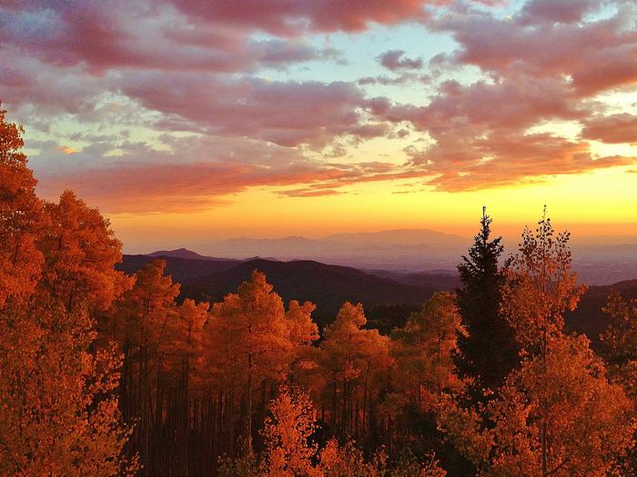
Santa Fe National Forest
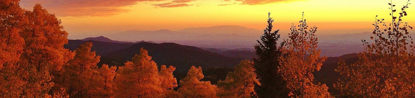
Rising from deserts, meadows and grasslands, the mesas, canyons and peaks of the Santa Fe National Forest are a place for re-creation. Whether gathering of families or gathering pinon nuts and firewood, the forest is a "querencia" - a special place. The past meets the present in this environment where year-round day-use, water focused recreation and trail opportunities offer a refuge of cool mountain air. Use by many cultures imbues the Santa Fe with a rich historical heritage highlighted by special sites found throughout the forest.
If you are interested in a specific Ranger District, click "Find an Area" on the right. Click on the Ranger District name or Recreational Area for an overview, or the + for a listing of sites and trails.
RecAreaDirections
Open with Google Map
Misc
| Stay Limit | |
| Reservable | false |
| Keywords | |
| Map Link | |
| Contact Phone | |
| Contact Email |
Permits info
Facilities
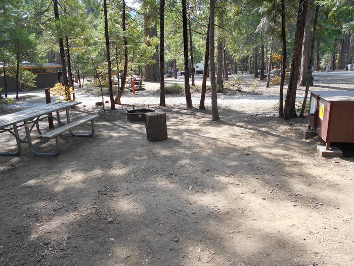
Panchuela Campground
List of CampsitesOverview
Panchuela campground is nestled at the edge of the Pecos Wilderness with Panchuela Creek running along the eastern side of the campground. At a little over 8,300 feet in the Santa Fe National Forest, visitors to the campground escape from the warmer temperatures of the city and enjoy the moderate temperatures of the Sangre de Cristo Mountains. There are 6 units on the campground and are within walking distance of the parking lot. Panchuela campground usually opens in mid-May through mid-November. With the nearby wilderness, the sites make the perfect base camp for those looking to take day hikes into the wilderness.
Recreation
With the nearby Panchuela Trailhead, there is easy access to the Pecos Wilderness where visitors can hike the expansive trail system of the wilderness. Panchuela is also a few minutes drive from the Winsor Creek and Winsor Ridge Trailhead, all providing scenic views of the surrounding mountains. Fishing is popular with nearby Cowles Fishing Pond and the wild and scenic Pecos River. There are excellent fishing spots all along Panchuela Creek and the Pecos River, within minutes of the campground.
Facilities
There are a total of six campsites at Panchuela. Three units have three-sided shelters with a fire place and picnic table. All sites have fire rings or fire ring grill combos with bare ground for tent camping. Bathrooms and trash bins are located at the parking lot and there is a host on site. Hand pumped water spigots are also located in the parking area and are a two minute walk from the farthest campsite. All of the sites have ample shade and visitors often enjoy relaxing in their hammock with plenty of trees to choose from. Four sites are situated on the banks of Panchuela Creek, close enough to hear the soothing sounds of the water.
Natural Features
The campsites are surrounded by views of the mountains and the gorgeous shades of green from the mixed conifer and aspen. In the fall, the mountains gleam a glorious gold as the aspen leaves begin to change color. A variety of wildlife are seen in the surrounding forests including deer, elk, various species of songbirds and raptors, and the occasional black bear. Not far from the campground in an open meadow, campers can see the charming rustic cabins that forest service volunteers and employees stay in when working in the wilderness.
Nearby Attractions
There are numerous State Park fishing areas along the Pecos River. Pecos National Historic Park is 50 minutes away and is the home of prehistoric archeological ruins, 19th century ranches and a battlefield from the American Civil War. There are other nearby campsites with similar scenery to Panchuela available on a first come first serve basis. They are Cowles campground, and Holy Ghost campground.
Clear Creek Group Campground (NM) Campground
List of CampsitesOverview
Clear Creek Group Campground is less than a two hourdrive from the Albuquerque area, and provides relief from the New Mexico heat with the cool shade and refreshing air of the pines and mountains. The group campground is located in the last loop of the Clear Creek Campground, alongside the serene Clear Creek.
Recreation
Local streams and the San Gregorio reservoir provide fishing opportunities for anglers, and hikers will delight in the many hiking opportunities in the nearby San Pedro Parks Wilderness.
Facilities
The group campground can host up to 70 people, and has parking for a large bus or RV available. It’s location is far enough from the individual sites to make the place feel like your own campground. A large ramada with picnic tables and pedestal grill are available for the group area, along with a vaultedtoilet. There is drinking water available and a host on site to answer any questions. The campground opens in May and closes in mid October. This is a popular spot for Albuquerque recreationists, so make reservations early!
Natural Features
Evergreen ponderosa pines and Engelman spruce make up the forest around the campground, a welcome sight for those escaping the heat. The majesty of the Jemez Mountains provides amazing scenery for those inthe campground and for scenic drives through the forest. A variety of wildlife call this place home including black bears, mule deer, elk, and a plethora of bird species.
Paliza Group Campground Campground
List of CampsitesOverview
Paliza Group Campground is found north of the small community of Ponderosa, surrounded by ponderosa pines and views of the stunning cliff faces of majestic mesas. There are two group areas within the campground, with walk in and drive in sites found separately in each loop. The group campground generally opens in mid-May and closes in mid-October. It’s location is ideal for enjoying quiet, star filled nights as it is far away from major cities. The Jemez National Recreation Area is a short drive away and providesmany opportunities to enjoy the Santa Fe National Forest.
Recreation
Paliza Group Campground is not far from NM Highway 4 and the popular Jemez National Recreation Area. Scenic day hikes, hot springs, and historical landmarks can be found nearby. Fishing is popular on the nearby San Antonio Creek with plenty of fishing sites available.
Facilities
The Owl Loop sites have paved driveways along with standard campsite amenities like a fire ring grill, picnic table, lantern post, and gravel tent pads. There is a large outdoor picnic area for the Owl Loop and comes with pedestal grills, a ramada, picnic tables, and plenty of room for large gatherings. The Red Tail Loop sites are walk-in sites, but the parking is close by with additional parking for RVs and trailers available. Red Tail Loop sites have a picnic table, fire ring grill, lantern posts, and gravel tent pads provided, with a gravel walkway connecting all the sites. There are recently renovated vaulted toilets found in both loops.
Natural Features
The short driveway from Forest Road 10 to the group campground is scenic, with riparian trees changing to towering ponderosa pines as the road climbs in elevation. Spectacular views of the surrounding mesas and clear blue skies are hallmarks of this campground. The dark greens of the conifers stand out against the bright yellows of flowering chamisa in the summer, and the yellows and reds of fall foliage provide a variety of scenery through the seasons.
Nearby Attractions
The East Fork of the Jemez National Wildand Scenic River can be accessed nearby. The Valles Caldera National Preserve is conveniently located north of Forest Road 10 on NM 4. An impressive geological formation known as Battleship Rock is worth stopping to look on NM 4, north of the town of Jemez Springs. The town itself has art created by locals, hot springs, and a restaurant for those not wanting to cook.
PALIZA Campground
List of CampsitesOverview
Paliza Campground sits beneath sandstone cliffs on the Jemez Ranger District of the Santa Fe National Forest. The area is replete with culture, offering visitors a glimpse into the past. Ample recreation opportunities exist at or near the campground, which makes it a wonderful outdoor destination.Recreation
Hiking, wildlife viewing and scenic drives are some of the popular activities enjoyed near the campground. Striking views of an ancient volcanic crater amid the rolling hills, can be seen from the Cerro Pelado Scenic Overlook, about 11 miles from the campground.Off-road vehicle trails and numerous hiking and mountain biking trails surround the campground.
Facilities
There is no water.
The campground offers a variety of sites available for tent and RV camping. The majority of the sites are single-family occupancy, but the campground also has double and even triple-sized units, as well as a group site that can accommodate up to 100 people. Some sites are available on a first-come, first-served basis.
Picnic tables, lantern posts and campfire rings with grills are provided, as are accessible vault toilets. Roads within the campground are paved.
Natural Features
The newly refurbished campground sits in a forested area at the top of a hill with views of the Jemez Valley below. It was originally the site of a 1930s Civilian Convservation Corps base camp. Remnants of that camp, including log lean-to's and adirondack shelters with rock fireplaces, can be found within the campground.A small stream runs alongside the campground and sandstone cliffs on the nearby mesas provide excellent photographic and sightseeing opportunities. A small tract of private land is located north of the campground and common courtesy is appreciated.
Nearby Attractions
The campground is located five miles northeast of the town of Ponderosa, New Mexico, an area known for its vineyards and winery with a tasting room.The Jemez Pueblo and the Walatowa Visitor Center, both of which provide rewarding cultural experiences, are just 11 miles from the campground in the town of Jemez. The quaint community offers shopping and dining opportunities, as well as a variety of recreational opportunities.
HOLY GHOST GROUP AREA Campground
List of CampsitesOverview
Holy Ghost Campground sits in the Santa Fe National Forest on the edge of the Pecos Wilderness within Holy Ghost Canyon. The Holy Ghost Creek runs alongside the campground. Numerous trails in the area lead hikers and horseback riders into the surrounding wilderness area.
Recreation
Hiking and horseback riding are the most popular activities at Holy Ghost Campground. The trailhead at the campground accesses a 350-mile network of trails within the Pecos Wilderness, including Holy Ghost Trail, which accesses Skyline Trail and beautiful Stewart Lake.Anglers enjoy fly-fishing on Holy Ghost Creek. Brown trout and stocked rainbow trout are found in the cool waters.
Facilities
The campground offers one accessible group campsite that can accommodate up to 30 people. It is equipped with a picnic shelter, tables and a grill.
Group campsite is nearby individual campsites which are available on a first come, first served basis. These sites each contain a grassy tent pad, table and campfire ring with grill.
Accessible vault toilets and trash collection are provided. No hookups are available. The road to the campground is narrow in places.
Natural Features
The campground is nestled among a ponderosa pine and fir forest, right where aspen trees begin to grow, in the Sangre de Cristo Mountains of New Mexico. Vibrant wildflowers bloom throughout the area in the summertime.
The Holy Ghost Creek borders the campground, and offers scenic views of the forest and mountains. A variety of wildlife and birds are found in the surrounding area.
Nearby Attractions
The town of Pecos is located about 16 miles south of the campground.JACKS CREEK GROUP AREA Campground
List of CampsitesOverview
Jack's Creek Group Area is a forested, high-elevation campground about 50 miles from Santa Fe. Perfect for family reunions, recreation events and other large group gatherings, the campground has two group units available that can each hold 40 people. The campground sits at approximately 8,000 feet in the Santa Fe National Forest. Visitors enjoy the moderate temperatures and cool mountain breezes while the campground is open from mid-April to mid-November. The surrounding wilderness provides astounding views.Recreation
Hikers find this campground convenient to the popular Jack's Creek Trail nearby. Fishermen also enjoy fishing for rainbow and brown trout in Jack's Creek.Facilities
A campground host patrols the campground on a routine basis and is available to answer questions. Campers can lock the gate after their group is settled into the site, if desired. One of the sites (Group B) is accessible. All of the roads are the paved, so low clearance vehicles can also reach it.Natural Features
Located in the Sangre de Cristo Mountains, Jack's Creek is on the border of the Pecos Wilderness, which features 160,000 acres of majestic mountain scenery, high mountain lakes and the Pecos River. The campground is heavily forested with fir trees intermixed with aspens, which shimmer with golden foliage in the fall. The trees provide plenty of shade if desired, yet enough space to enjoy the sun as well. The creek is adjacent to the campground. A variety of wildlife, such as elk, mule deer, migratory birds, bald eagles (in winter) and other raptors inhabit the forest.Nearby Attractions
The City of Santa Fe is just over a one-hour drive away.Black Canyon Campground (Santa Fe National Forest, NM) Campground
List of CampsitesOverview
At 8475 feet in elevation, Black Canyon Campground is in a great location to experience some of the finest mountain scenery the Southwest has to offer. The facility is newly renovated and provides access to a variety of outdoor recreational activities. Campers can enjoy warm days and cool weather in the summer months, providing a scenic getaway from the desert heat.
Recreation
Hikers enjoy a pleasant hiking 1.5-mile trail that loops around the campground and into the surrounding forest. Several additional hiking, mountain biking and horseback riding trails are located nearby.The Pecos Wilderness can be accessed eight miles from the campground, with many trails leading to majestic peaks and through valleys, canyons and forested groves.
Many recreation opportunities exist along Highway 475, both above and below Black Canyon Campground, including hiking and biking trails and picnic areas. In the winter, the area offers both Nordic and alpine skiing.
Facilities
The campground offers many single and double-family sites, most of which are accessible. Some sites are designated as walk-to sites for tent camping only. A few are available on a first-come, first-served basis.
Each site is equipped with a table and campfire ring with grill. Accessible vault toilets are provided. The highway to the campground is paved. There is currently no water available on the campground, bring your own water.
The campground is adjacent to New Mexico's Hyde State Park, where a dump station is available.
Natural Features
The campground is situated in a forest of pine, aspen and fir trees. A good mix of sun and shade is found throughout the area. Many beautiful views are found in the surrounding forest.Nearby Attractions
The campground is located about seven miles northeast of the town of Santa Fe, New Mexico. This unique town is known for its cultural heritage, art galleries and museums.contact_info
This location has limited staffing. Please call (505) 753-7331 for general information.JEMEZ FALLS (NM) PICNIC AREA Campground
List of CampsitesOverview
Jemez Falls Picnic Area is great place to spend the day, especially when planning a day hike to nearby Jemez Falls on the Jemez District of the Santa Fe National Forest. The lands are known for immense cultural heritage of the Jemez people, as well as a therapeutic natural warm springs.Recreation
A trailhead to Jemez Falls is located within the day-use area. It leads to both Jemez Falls and McCauley Warm Springs. Visitors also enjoy fishing the Jemez River, a small trout stream stocked with catchable rainbow trout.Facilities
The accessible picnic area is equipped with a shelter, tables and large grills. Accessible vault toilets and trash collection are provided. The site can accommodate up to 50 people. A large parking area is on-site.
For the 2021 Season - drinking water is provided in the day-use area.
Natural Features
The picnic area is situated in a forested area at an elevation of 7,880 feet. Nearby Jemez Falls cascades 70 feet over a rocky cliff surrounded by boulders and pines.Nearby Attractions
The picnic area is located 15 miles northeast of Jemez Springs, New Mexico. San Diego Canyon overlook is located nearby and provides a stunning view of the canyon. Nearby Valles Caldera and Bandelier National Monument provide plenty of scenic views and geographic history.
SAN ANTONIO CAMPGROUND Campground
List of CampsitesOverview
San Antonio Campground is adjacent to the San Antonio River, tucked into a forest of ponderosa pine at 7,600 feet above sea level. This popular campground is open from May through October in the Santa Fe National Forest. Visitors should be prepared for hot summer days and cool nights.San Antonio Campground was completely rebuilt and reopened in August 2010. It is designated as a reduced impact and recycle campground.
Recreation
A paved walking trail along the river provides access for fishing. Anglers can fish for rainbow trout. Visitors enjoy wading in the river on hot summer days.The campground offers easy driving access to several recreational sites nearby, including the popular La Cueva Picnic Site, Spence Hot Spring Trailhead, Battleship Rock Trailhead and a couple of fishing sites along the San Antonio River.
Facilities
The campground has 20 standard sites that can accommodate tents, trailers and RVs. A group area on the north end of the campground includes a pavilion that can accommodate up to 100 people.The group area includes nine tent sites. Accessible sites are located on the south end of the campground.
Sites are equipped with picnic tables and pedestal grills, and sites 1-6 have water and electric hookups. Site 3 can accommodate two RVs.
Drinking water and vault toilets are provided. Parking areas, spurs and roads within the campground are paved. A camp host is available during the peak season. Visitors are encouraged to pack out trash, but recycling bins are provided.
Natural Features
Some of the finest mountain scenery in the Southwest is found in the 1.6 million acres within the Santa Fe National Forest. Elevations range from 5,300 to 13,103 feet at the summit of Truchas Peak, located within the Pecos Wilderness.The diverse ecosystems of the Santa Fe National Forest are home to a variety of wildlife species. The ponderosa pine forests at 6,000-9,500 feet provide habitat for the Jemez Mountain salamander, northern goshawk, Merriam's turkey, Abert's squirrel and hairy woodpecker.
Nearby Attractions
The 163-mile Jemez Mountain Trail Scenic Byway passes amazing geological formations, ancient Indian ruins and an Indian pueblo. The area is rich in logging, mining and ranching heritage.Santa Fe Area Facility
There are several excellent trail opportunities minutes from the city of Santa Fe. Just West of Santa Fe is the trail up Atalaya Mountain. Numerous other trails into the Forest are found along the road up to the Santa Fe Ski Basin.
Oak Flats Picnic Site Facility
15 miles from historic Las Vegas on NM 65 and FR 263. Uses: Picnicking, fishing. Facilities: 7 picnicking units, vaulted toilets, tables and fire pits. Special Instructions: NO CAMPING ALLOWED. NO WATER.
Atalaya - Upper Trailhead Facility
This trailhead starts within a residential area above the lower trailhead near St John's College.
Las Casitas Fishing Site Facility
ALERT: This fishing access is closed due to resource amenity constraints. Please call the Jemez Ranger District (Ph: 575.829.3535) for current conditions.
The Las Casitas Fishing Site offers parking and access to the Lower Jemez River. Located on NM HWY 4 approximately eight miles south of Jemez Springs.
Uses: Fishing
Facilities: Paved parking, vault toilet.
Special Instructions: Clean fish away from river and parking area. Day use area only; no overnight camping.
Po-shu-oinge' Interpretive Site (minor) Facility
Po-shu-oinge' interpretive site is near the turn off to Abiquiu. A short trail takes the visitor above the valley to look over a cultural site where the outline of a Pueblo Community can be seen. An artist conception of the original site helps the visitor to visualize the area as it might have been.
La Cueva Picnic Site Facility
Located along the San Antonio River in the community of La Cueva, this popular picnicking and fishing site is a favorite with families and fishermen. The San Antonio River runs through the picnic area and individual sites are located on both sides of the river offering cool spots to enjoy an afternoon, or morning.
Uses: Picnic, hiking and fishing.
Facilities: Site amenities include 12 picnic units with grills. vault toilets. The picnic site is universally accessible.
Special Instructions: This picnic site is designated as a reduced impact picnic site. Please pack out your trash and leave the site clean for others to enjoy. Charcoal only in pedestal cooking grills.
Bluffs Fishing Site Facility
NOTE: This fishing facility remains closed due to reduced resouce amenity constraints. Please park outside the gate and access fishing stream through the site.
The Bluffs Fishing Site offers parking and access to the Lower Jemez River. Located on the Jemez Mountain Trail National Scenic Byway (NM HWY 4), approximately five miles south of Jemez Springs.
Uses: Fishing.
Facilities: Paved parking and fishing access.
Special Instructions: Clean fish away from river and parking area.
Las Conchas Day Use Site Facility
Located adjacent to the East Fork Jemez River the Las Conchas Day Use Site offers fishing access and picnic facilities. The picnic area is in an alpine meadow with the river meandering along side the site. Hiking trails and the Valles Caldera are close by.
Uses: Picnics, hiking and fishing.
Facilities: Amenities include nine picnic sites with grills. Vault toilet.
Special Instructions: Day use only, no overnight camping. Charcoal only in pedestal cooking grills.
Battleship Rock Trailhead Facility
Trailhead parking for the East Fork Trail (Forest Trail 137) is located north of Battleship Rock Picnic Area, off NM State Highway 4, about five miles north of the Village of Jemez Springs. To access the East Fork Trail walk through the picnic area, trail is located to the east side of the pavillion. Please be respectful to picnic users.
From the trailhead it is two miles to McCauley Warm Spring, and four miles to Jemez Falls Trailhead. The trail is rated for moderately difficult hiking, typically uphill to Jemez Falls. The trail continues one mille to the East Fork Trailhead parking area and ends at the Las COnchas Trailhead. The total one way trail length is approximately 10 miles.
Uses: Hiking and fishing
Facilities: Paved parking at trailhead, vault toilet and trail information kiosk
Special Instructions: No overnight camping within one-quarter mile of trailhead. Back pack camping is allowed more than 400 feet from McCauley Warm Spring and 200 feet from river and springs. No glass contrainers; use only plastic. Pack out all trash and leave the trail clean for others to enjoy.
Vista Grande Overlook Observation Site Facility
Overlook deck located just below Santa Fe Ski Area at a pullout. Interpretive viewing of area mountains.
Jacks Creek Horse Camp Facility
Beautifully located among aspens and mixied conifer, you will definitely get the mountain experience at Jack's Creek. Uses: camping, hiking, horseback riding. Facilities: 8 units for equestrian camping. 5 12'x12' corrals, with a highline or picket line on 3 others. 15 spaces for horse trailer parking. Potable water, trash bins, vaulted toilets, tables and grills. Facilities are available to people with disabilities. Special Instructions: RVs are welcome, but there are no hook-ups or showers. Users are encouraged to recycle and pack out trash. Please visit the Leave No Trace website for more information about frontcountry and backcountry outdoor ethics at www.lnt.org.
NO ATVs ALLOWED IN CAMPGROUND
Coyote Ranger District Facility
The Coyote Ranger District Office is located along NM State Highway 96 approximately 21 miles from the Junction of SH 84 & SH 96. The Coyote Ranger District contains approximately 265,100 acres, of which 24% is designated wilderness, and semi-primitive in nature. Elevation ranges from 10,600 feet in the spruce-fir forests and high mountain meadows of the San Pedro Parks Wilderness to 6,200 feet along the Rio Chama Wild and Scenic corridor as well as the Chama River Canyon Wilderness.
East Fork Trailhead #137 Facility
The East Fork Trailhead is located on NM State Highway 4, midway along the East Fork Trail (Forest Trail 137), approximately one mile east of the Jemez Falls Campground..
Cross the highway, the East Fork Trail winds to the Jemez Falls Trailhead is an easy downhill one mile hike. The trail meanders through aspen and pines as it trends downhill towards Jemez Falls. Hiking east and slightly uphill the trail leads through aspen groves and pine/fir forests with views of the 11,000 foot Redondo Peak along the 5 mile hike in rolling terrain.
Uses: Hiking and parking
Facilities: Vault toilets, picnic tables and paved parking.
Special Instructions:
Pack out trash and leave the trail clean for others to enjoy.
No camping within one-quarter mile of trailhead, 400 feet of McCauley Warm Spring and 200 feet of river and springs. No glass containers are permitted; use only plastic containers. Pets must be leashed at all times while in trailhead area and on trail.
San Diego Fishing Site Facility
ALERT: This fishing access is closed due to resource amenity constraints. Please call the Jemez Ranger District (Ph: 575.829.3535) for current conditions.
The San Diego Fishing Site offers parking and access to the Lower Jemez River. Located on NM HWY 4 approximately seven miles south of Jemez Springs.
Uses: Fishing.
Facilities: Paved parking.
Special Instructions: Clean fish away from river and parking area.
Holy Ghost Trailhead Facility
Uses: hiking, backpacking, fishing. Facilities: vauled toilet at Holy Ghost Campground, parking, and information kiosk. Special Instructions: Users are encouraged to recycle and pack out trash. Please visit the Leave No Trace website for more information about frontcountry and backcountry outdoor ethics at www.lnt.org.
Avoid driving off the pavement on the high bank (uphill side) of the road to protect endangered plant habitat. Take only photos of flowers, do not pick them. Leaving them provides for pollinators (butterflies and bees) and seeds for next year’s flowers.
Please remove mud, seeds, vegetation and debris from everything (vehicles, stock, tents, blankets, clothes, etc.) before entering the Santa Fe National Forest, especially Holy Ghost Canyon.
Atalaya- Lower Trailhead Facility
The trailhead starts near St John's College.
Lower Dalton Picnic Site Facility
Located 6 miles north of Pecos on NM 63. Uses: Picnicking, fishing. Facilities: 6 units, tables, grills and fire pits, 16 parking spaces, vaulted toilet. A pullout with parking spaces for fishing is available. Special Instructions: No camping allowed. No toilet. No water.
Spence Hot Spring Trailhead Facility
Spence Hot Spring is reached from a short hike from the parking area. Located five (5) miles north of Jemez Ranger District Office. There is no location sign for the spring. The paved parking area accomodates seven vehicles.
The popular Spence Hot Spring includes a small pool that accomodate a relativel low number of people. Although the spring maintains a 95 degree temperature the water has been cooling for the last several years and is considered to be a warm spring at approximately body temperature.
The area has suffered considerable resource damage due to overuse. No glass containers, camping or campfires are permitted along the trail and at the spring.
Uses: Soaking, fishing and hiking.
Facilities: Paved parking, hot spring.
Special Instructions: Please be considerate of the hot spring and surrounding area. The water quality is not monitored so there are possible health hazards. Visitors should avoid getting water in their noses to minimize the risk of contracting a potentially fatal parasitic amoeba called Naegleria Fowleri, common in warm springs. Also, watch for Poisen Ivy along the trail.
Nudity is a violation of State Law and violators will be sited,
Please pack out all trash and leave the area enjoyable for others to use.
Aspen Vista Picnic Site Facility
Aspen Vista is a small picnic site just below Aspen Ski Basin. It also serves as a trail head to the road to Tesuque Peak and the new Alamo Vista Trail to the top of the Santa Fe Ski Hill.
Windy Bridge Picnic Site Facility
Windy Bridge picnic site is located 12 miles north of Pecos on NM 63. Uses: Picnicking, fishing in the Pecos River. Facilities: 6 units, 8 tables and 7 rock grills, vaulted toilet and 12 parking spaces. Special Instructions: NO CAMPING ALLOWED. NO WATER. NO TRASH BINS. Self-contained RVs can park in the parking lot.
Espanola Ranger District Facility
Recreation opportunities within the Espanola Ranger District range from the high alpine trails in the Pecos Wilderness to the lower elevation areas in the Caja del Rio.
There are four geograpic regions that make up the Espanola Ranger District within the Santa Fe National Forest. These are the Forest lands South of Abiquiu, the Forest lands around Los Alamos, the Forest Lands West of Santa Fe known as the Caja del Rio, and the Forest Land North of Santa Fe within the Sangre de Cristo Range. This last category is further divided below according to the most popular recreation access. Recreation destinations to the North are often accessed from Borrego Mesa. In the middle, the most popular access is from the Santa Fe Ski Basin, and to the South are the recreation destinations closest to the city of Santa Fe. A general map of popular recreation sites and trails in each of these areas can be seen by clicking on the map area of interest below:
- Click here for a map of the general recreation areas within the Espanola District.
- Click here for the Abiquiu Area,
- Click here for the Los Alamos Area,
- Click here for the Caja del Rio Area,
- Click here for the Borrego Mesa Area.
- Click here for the Aspen Basin Area .
- Click here for Santa Fe Area Trails.
- Click here for North Espanola Area Trails
Quarterly Trail Condition Report for the Pecos Wilderness updated June 1, 2015. For further information on trails and specific recreation opportunities, please see the categories below:
Abiquiu Area Facility
The Santa Fe National Forest around Abiquiu has scenic trails in a region that is more remote and less visited than other areas of the Forest. Many of the trails were burned over and damaged by subsequent flooding in the 2010 South Fork Fire and again in the 2011 Las Conchas Fire. Since then, most trails have been restored and reopened. Many areas remain unaffected and offer great recreation opportunities. A good map and orienteering skills are recommended for many of the lesser used trails that can become overgrown and hard to find and follow.
Jemez Falls Trailhead Facility
The Jemez Falls Trailhead is located adjacent to the Jemez Falls Group Area. To get to the trailhead use the Jemez Falls Camground turnoff and follow the road past the campground and day use area.
A short 1/4 mile hike will get you to the Jemez Falls Overlook, the highest falls in the Jemez Mountains.
The trailhead is located midway along the East Fork Trail. Hiking northeast one mile is moderately easy to the East Fork Trailhead and another 5 miles to the Las Conchas Trailhead. Hiking west will lead downhill to the Battleship Trailhead, approximately 4 miles.
Uses: Hiking and fishing
Facilities: Paved parkiing and toilets. Trail 137 is accessed from the trail head.
Special Instructions: Pack out all trash and leave the trail clean for others to enjoy. Cutting live vegetation is prohibited. Backpackers camp at least 400 feet from McCauley Warm Springs and at least 200 feet from the river and springs.
Winsor Ridge Trailhead Facility
Winsor Ridge Trailhead is access point for Winsor Ridge Trail #271 and trail to Panchuela Campground and Trailhead. Located 20 miles north of Pecos on NM 63. Uses: Hiking, Backpacking, Horseback Riding. Facilities: vaulted toilet, trash bins, trailhead kiosk, parking for passenger vehiles & trailers. Special Considerations: Users are encouraged to recycle and pack out trash. Please visit the Leave No Trace website for more information about frontcountry and backcountry outdoor ethics www.lnt.org.
Santa Fe Alpine Ski Area Facility
Ski Santa Fe is at the top of the Hyde Park Road. The Ski Area is permitted on Forest Service Land. See Ski Santa Fe website for more information.
Seven Springs Picnic Site Facility
Seven Springs Picnic Area is located in proximity to the State Fish Hatchery at Seven Springs.
Uses: Picnics, hiking and fishing
Facilities: The site has seven picnic units and is adjacent to the Rio Cebolla. Vault toilets. No water is available at this site.
Special Instructions: Please pack out trash and leave the area clean for others to enjoy. Clean fish away from picnic area. Cutting live vegetation is prohibited.
Upper Dalton Fishing Access Fishing Site Facility
6 miles north of Pecos on NM 63. Uses: Fishing, picknicking. Facilities: A pullout with parking spaces for fishing, vaulted toilet.
Rio Chama Wild & Scenic River Facility
The Rio Chama is about 120 miles long, beginning in the southern San Juan Mountains of South-Central Colorado, it joins the Rio Grande near Espanola, NM. In 1978 the River was designated as a State Scenic and Pastoral River thus designating part of the Santa Fe National Forest as Chama River Canyon Wilderness. Thirty-one miles of the river were further protected as a Federal Wild and Scenic River in 1988.
All commercial outfitters must have a special use permit, usually issued for the Rio Chama by the Bureau of Land Management Taos Field Office. Private boaters may float the Scenic portion of the Rio Chama (downstream from the Christ in the Desert Monastery without a permit, but overnight float trips on the Wild portion of the Rio Chama (above the Monastery) are also required to have a permit from the Bureau of Land Management Taos Field Office.
A float down the river offers access to many interesting side canyons, with trails leading to peaks and mesa tops. This is the country of brightly colored cliffs and fascinating badlands made famous by artist Georgia O'Keeffe.
The river corridor is a flyaway for many bird species which depend on the water and riparian vegetation. Ducks mergansers, Canada geese, great blue heron, raptors and neo-tropical migrator species can all be seen along the river. Large number of swallows make their nests on the riverside cliffs.
The Rio Chama Canyon provides excellent habitat for raptors. Both bald and golden eagles are found within the canyon, with several species of hawks, owls, and falcons observed occasionally during the year.
Fishing is allowed in accordance with the NMG&F Dept. regulations. Major fish species found in the Rio Chama include brown trout, Rio Grande chub, fathead minnow, rainbow trout, longnose dace, and carp.
Motorized vehicles or mechanized equipment are prohibited in the Chama River Canyon Wilderness.
Please follow the Principles of Leave No Trace
- Plan ahead and prepare
- Travel and camp on durable surfaces
- Dispose of waste properly
- Leave what you find
- Minimize campfire impacts
- Respect wildlife
- Be considerate of other visitors
Borrego Trailhead Facility
The Borrego Trailhead is more traditionally thought of as the trailhead from Borrego Mesa. The Borrego Trail goes north -south between Borrego Mesa and the Aspen Ranch Trailhead near the Santa Fe Ski Basin.
Las Conchas Trailhead Facility
Located on NM State Highway 4 appoximately 3/4 mile south of the Las Conchas Picnic Area, the Las Conchas Trailhead provides access to the eastern most terminus of the East Fork Trail (Forest Trail 137). Starting elevation of the trail is 8,400 feet above sea level. The trail follows the Wild and Scenic East Fork-Jemez River and provides views of meadows, wildflowers and wildlife.
The trail is rated as easy for the first 2 miles and becomes moderate for the rest of the way to the East Fork Trailhead(five miles).
Uses: Hiking and fishing
Facilities: Paved parking and trail access
Special Instructions: No camping is allowed within one-quarter mile of the trailhead or within 200 feet of the river. No glass containers; use only plastic containers. Pack out all trash and leave the trail clean for others to enjoy.
Jemez Ranger District Facility
The Jemez Ranger District Office is located at 051 Woodsy Lane in the village of Jemez Springs, New Mexico. It can be reached by calling (575)829-3535.
Rincon Fishing Site Facility
The Rincon Fishing Site offers parking and access to the San Antonio River. Located on NM HWY 4 approximately six miles north of Jemez Springs.
Uses: Fishing.
Facilities: Paved parking.
Special Instructions: Clean fish away from river and parking area. day use area only; no overnight camping.
Burro Basin Trailhead Facility
The Burro Basin Trailhead located at the end of Forest Road 263. Uses: parking, hiking, backpakcing, horseback riding.
Borrego Mesa Area Facility
The Borrego Mesa area is the gateway to many of the trails in the Western portion of the Pecos Wilderness. The country is rugged and beautiful and generally more lightly used than other parts of the Pecos Wilderness. There are five main trail heads each connecting to trails within the Pecos Wilderness. A good map and orienteering skills are recommended for many of these trails due to lighter use and becoming overgrown such that in many locations the trail can be difficult to find and follow.
North Espanola Area Facility
The Espanola District extends west of West of Highway 84 on the road to Abiqiui. There are several trail heads for hiking and horse back riding within a short distance of Espanola. Many of these trails are open in the winter season when other parts of the Forest are closed.
La Junta Fishing Site Facility
ALERT: This fishing access is closed due to resource amenity constraints. Please call the Jemez Ranger District (Ph: 575.829.3535) for current conditions.
The La Junta Fishing Site offers parking and access to the Lower Jemez River. Located on NM HWY 4 approximately nine miles south of Jemez Springs.
Uses: Fishing
Facilities: Paved parking, vault toilet.
Special Instructions: Clean fish away from river and parking area. Day use only; no overnight camping.
Aspen Basin Area Facility
Aspen Basin is at the base of the Santa Fe Ski Basin and is the most popular trailhead within the Espanola Ranger District for access into the Pecos Wilderness. Convenient to Santa Fe, there are numerous trail heads and trails all along the scenic Santa Fe National Forest Scenic Byway, also known as Hyde Park Road.
Spanish Queen Picnic Site Facility
This popular picnic area is located in the scenic San Diego Canyon, with spectacular red rock canyon and mesa views. Come prepared for warm days and cool evenings during the summer months and cold winter temperatures. The Jemez River offers excellent fishing opportunities (valid State fishing license required) and wildlife viewing. Fishing is best during the Winter months. Located about five miles south of Jemez Springs on the Jemez Mountain Trail National Scenic Byway (NM HWY 4).
Uses: Picnics, hiking and fishing.
Facilities: The picnic area has 12 picnic sites, most have direct access to the Lower Jemez River. Each picnic site has a table and grill and many have shade canopy. Vault toilets. No drinking water available.
Special Instructions: Fishing along the Lower Jemez River is best during winter months. Clean fish away from picnic and parking area. Cutting live vegetation is prohibited. Charcoal only in pedestal grills.
Jemez Falls Group Picnic Site Facility
Popular for weddings and extended family reunions, the group use site is located in a stunning Ponderosa Pine and forest meadow environment, adjacent to the East Fork Jemez River and Jemez Falls Campground.
Come prepared for warm summer days and cooler evenings. Jemez Falls, largest waterfall in the Jemez Mountains, is in close proximity. The Valles Caldera National Preserve and Bandelier National Monument are within a short driving distance.
Uses: Group picnics and hiking. Open area for volleyball.
Facilities: The site accomodates up to 100 people and has a group pavillion, picnic tables. Vault toilets.
Special Instructions: Advance reservations required. Cutting live vegetation is prohibited. Charcoal only in cooking grills.
Caja Del Rio Area Facility
The Caja del Rio area is a lower elevation and drier section of the Santa Fe National Forest. This is mainly a Piñon-Juniper dominated vegetation zone with areas of sage and mixed grasses. It is often open for recreational opportunities when the rest of the Forest is snowed over. Watch for seasonal road closures due to wet and very muddy roads. It is another good area for solitude and lesser travelled trails.
Little Tesuque Picnic Site Facility
Little Tesuque Picnic Site was rennovated in 2011. There is a vault toilet, individual and group picnic sites. It is the first Forest Service Picnic site as you travel up Hyde Park Road.
Jacks Creek Trailhead Facility
The Jacks Creek Trailhead is located 21 miles on NM 63. Uses: Trailhead parking and access for hiking, backpacking, horseback riding. Facilities: Vault toilets, trash bins, drinking water. Special Instructions: Users are encouraged to recycle and pack out trash. Please visit the Leave No Trace website for more information about frontcounty and backcountry outdoor ethics at www.lnt.org.
San Diego Canyon Overlook Overlook Site Facility
San Diego Overlook Site offers magnificant views of San Diego Canyon. Located on Jemez Mountain Trail National Scenic Byway(NM HWY 4), the site provides accessible restrooms and a paved trail out to the edge of the canyon.
Uses: Scenery and wildlife viewing.
Facilities: Paved parking, vault toilet, ADA trail to overlook.
Special Instructions: Popular for cross country skiing.
Iron Gate Trailhead Facility
Update April 25, 2016: Potable water is unavailable at this and all other campgrounds on the Pecos/Las Vegas Ranger District. The public is asked to bring water with them when camping and recreating on the forest. Thank you for your cooperation.
Situated above 9,000 feet, Iron Gate Trailhead provides the closest access to panoramic views of the Pecos Wilderness. Uses: hiking, backpacking, horseback Riding. Facilities: vaulted toiled, trash bins, and information board. Parking for vehicles and trailers. Special Instructions: Users are encouraged to recycle and pack out trash. Please visit the Leave No Trace website for more information about frontcountry and backcountry outdoor ethics at www.lnt.org.
Panchuela Trailhead Facility
Panchuela Trailhead is located at the end of Forest Road 305 accessed by NM 63 approximately 22 miles north of Pecos. Uses: Hiking, Backpacking, Horseback Riding. Facilities: Drinking water is available, vaulted toilet, and trash bins. Special Instructions: NO HORSE TRAILERS ALLOWED. The closest equestrian parking is located at Winsor Ridge and Jack's Creek Trailheads.
Links Tract Campground Campground
List of CampsitesPrimitive dispersed camping, 16 miles north of Pecos on NM 63, then 1 mile on FR 646. Uses: Camping. Facilities: Pit toilet, tables, and few fire pits. No water is available. Special Instructions: Users are encouraged to recycle and pack out trash. There are no fees.
Los Alamos Area Facility
The Espanola Ranger District includes the numerous trails within Los Alamos County that are on Forest Service managed lands. Many of these trails were consumed in the 2000 Cerro Grande Fire, and then again in the 2011 Los Conchas Fire. Although much restoration has been accomplished, not all of the trails have been re-established.
Winsor Trailhead #254 Facility
A popular trailhead for access into the Pecos Wilderness and other area trails. Located at the parking lot of Santa Fe Ski Basin.
Norski Trailhead Facility
Winter nordic ski trail head and summer hiking loop.
Cuba Ranger District Facility
Cuba Ranger Station, open Monday thru Friday, except for federal holidays.
Bear Wallow Trailhead Facility
Trailhead along the road to the Santa Fe Ski Area just above Hyde Park State Park. Good loop options.
Dark Canyon Fishing Site Facility
This fishing site provides access to the San Antonio River in San Diego Canyon. A restroom is available at this site. The parking area is also accomodates overflow parking for Spence Hot Spring.
Uses: Fishing
Facilities: Paved parking and vault toilet.
Special Instructions: Clean fish away from river and parking area. Day use only; no overnight camping.
Winsor Creek Fishing Area and Trailhead Facility
Located 20 miles north of Pecos on NM 63, one and a half miles on FR 121. Uses: Fishing, Hiking, Backpacking. Facilities: Vaulted toilet. Special Instructions: NO CAMPING ALLOWED. NO WATER. NO HORSE TRAILERS.
Glorieta Baldy Lookout Facility
Glorieta Baldy Lookout
Battleship Rock Picnic Site Facility
This popular day use only picnic area is located where the San Antonio and East Fork-Jemez Rivers meet. The picnic area is named for the rock formation known as Battleship Rock. Open sun-up to sun-down, the picnic area is often full on weekends and holidays.
Battleship Rock is a 200 ft. tall natural land form of volcanic rock, resembling a Navy warship. It provides the backdrop and frames the picnic area. The East Fork Jemez and San Antonio Rivers join at the picnic area and offer a cool streamside environment for family picnics, fishing and hiking.
Uses: Picnic, hiking and fishing
Facilities: 33 picnic sites with grills and picnic tables are available for day use. Paved access and parking; restrooms and drinking water available. Universally accessible.
The trail head for the East Fork Trail (ForestTrail 137), as well as parking for groups with multiple vehicles is directly north of the picnic area off NM State Highway 4. No overnight camping is permitted at the pcnic area or near the trailhead.
Special Instructions: This picnic facility is designated as a reduced impact and recycle picnic area, visitors are encouraged to recycle and pack out trash. Cutting live vegetation is prohibited. Charcoal only in pedestal cooking grills.
River's Bend Fishing Site Facility
The River's Bend Fishing Site offers parking and access to the Lower Jemez River. Located on NM HWY 4 approximately seven miles south of Jemez Springs.
Open seasonally, typically from May to October.
River's Bend Fishing Site will open May 4, 2012.
CLEAR CREEK CAMPGROUND (NM) Campground
List of CampsitesOverview
Less than two hours from the city of Albuquerque, Clear Creek Campground is nestled away in the Jemez Mountains. This cool oasis offers refuge from the New Mexico heat. Visitors delight in the hiking and fishing opportunities available in the shade of the pine covered Jemez Mountains.
Recreation
Local streams and the San Gregorio reservoir provide fishing opportunities for anglers, and hikers will delight in the many hiking opportunities in the nearby San Pedro Parks Wilderness.Facilities
Clear Creek Campground includes paved RV pads, fire rings, picnic tables, and vault toilets.Natural Features
The campground is located amid stunning ponderosa pines in close proximity to Clear Creek. In the fall, elk can be heard bugling in the early mornings and late evenings.
Nearby Attractions
The San Pedro Parks Wilderness, just north of the Clear Creek Campground, offers easy and scenic day hikes. The minimal grade increases of the trails into the San Pedro Parks make this wilderness an ideal backpacking destination for beginners and experienced backpackers alike. Three main trailheads, the San Gregorio, Palomas, and Los Pinos, are within driving distance of the campground.RIO DE LAS VACAS CAMPGROUND Campground
List of CampsitesOverview
Less than two hours from the city of Albuquerque, Rio de las Vacas Campground offers a cool oasis from the New Mexico heat. Visitors delight in the hiking and fishing opportunities available in the shade of the pine covered Jemez Mountains. A few of the campsites have the creek running along them, providing a soothing atmosphere for campers.
Recreation
Local streams and the San Gregorio reservoir provide fishing opportunities for anglers, and hikers will delight in the many hiking opportunities in the nearby San Pedro Parks Wilderness.Facilities
There are 15 campsites on the campground. Most of the campsites at Rio De Las Vacas come with a paved RV pad, fire rings, picnic table, and tent pads. The campground itself has paved roads, trash bins, vault toilets and a host on site.
Natural Features
The campground is located amid stunning ponderosa pines in close proximity to the Rio de las Vacas. The campground has a beautiful open meadow and scenic views of the surrounding Jemez Mountains. Fall brings migrating birds through the campground and the sounds of elk bugling to impress potential mates.
Nearby Attractions
The San Pedro Parks Wilderness, just north of the Rio de las Vacas Campground, offers easy and scenic day hikes. The minimal grade increases of the trails into the San Pedro Parks make this wilderness an ideal backpacking destination for beginners and experienced backpackers alike. Three main trailheads, the San Gregorio, Palomas and Los Pinos, are within driving distance of the campground.Chamisa Trailhead Facility
The Chamisa Trailhead is the first Forest Trail head as you go up the road to the Santa Fe Ski Basin.
Penas Negras #32 Facility
The elevation at the trailhead is about 9,300 ft. The trail has a gradual slope throughout and is the longest trail in the Cuba Ranger District. Destination is the San Pedro Parks about 8.2 miles from the trailhead where the trail meets trail #51 (Las Vacas). Water is scarce along the trail. Trail # 418 (Perchas) is crossed at about 2.5 miles. It is 4.2 from the junction to trail #51.
Johnson Mesa Campground Campground
List of CampsitesJohnson's Mesa is a dispersed camping area located east of Las Vegas on NM 65 and FR 153. Facilities: vaulted toilets, tables and grills.
FIELD TRACT CAMPGROUND Campground
List of CampsitesOverview
Field Tract Campground is located on the banks of the beautiful Pecos River. The campground is 10 miles north of the village of Pecos. Visitors enjoy Field Tract for its family friendly atmosphere, fishing and access to the Santa Fe National Forest.Recreation
Field Tract Campground offers excellent fishing access on the Pecos River. There are nearby picnicking sites with changes in scenery. There are multiple trails found in the canyon as well.
Facilities
This medium sized campground offers tent and RV camping, portable toilets, drinking water, picnic tables and grills. Six of the 15 units have three-sided shelters. Campsites are suitable for trailers up to 22 feet in length.
Natural Features
Situated on the Pecos River, Field Tract Campground provides an inviting forested setting. The Sangre De Cristo Mountains surround the Pecos Canyon and provide magnificent opportunities for wildlife viewing. Bald eagles migrate through the winter, and can be seen soaring throughout the canyon.
Nearby Attractions
Field Tract Campground offers direct access to the Pecos River and there are many terrific fishing opportunities nearby. There are also trailheads providing access to the Pecos Wilderness as well as climbing opportunities within 10 miles.JEMEZ FALLS CAMPGROUND Campground
List of CampsitesOverview
Jemez Falls Campground is located in a stunning Ponderosa Pine and forest meadow environment. The campground elevation is 7,880 feet above sea level. Come prepared for warm days and cool nights.
The Cerro Pelado Area closure prohibits members of the public from entering Trail 137 from access points South of the East Fork Trailhead. Entry is allowed North from the East Fork Trailhead to Las Conchas Trailhead.
Please remember that this campground is special. Help keep it clean and beautiful by using the trash dumpsters. Campground has 52 camp sites with picnic table and fire ring. Paved access which allows trailers and RV's up to 40 feet.
For the 2022 Season of Use, loop 4 sites are non-generator use areas. Loops 1-3 may use generators from 6:00 AM to 10:00 PM.
There is paved access from the highway and paved internal roads to individual campsites. There are no RV hook-ups. Drinking water is provided from spigots conveniently located throughout the campground. Vault toilets provide basic sanitation needs. A campground host is on duty.
Recreation
Overnight camping, fishing, and hiking are main attractions. Other recreational activities include outdoor photography and nature viewing. The campground is within the heart of the Jemez National Recreation Area.Facilities
The campground contains 51 overnight tent and RV/trailer campsites. For the 2021 Season of Use loops 3 and 4 sites are non-generator use areas.There is paved access from the highway and paved internal roads to individual campsites. There are no RV hook-ups at the campground. Drinking water is provided from spigots conveniently located throughout the campground. Vault toilets provide basic sanitation needs. A campground host is on duty during the summer camping season.
