
Columbia River Gorge National Scenic Area
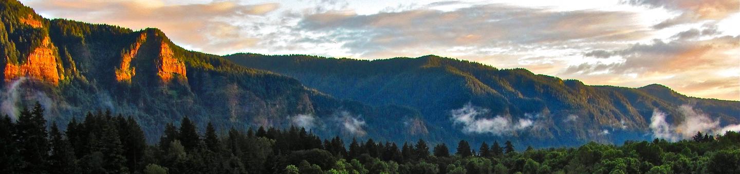
From watersports to wonderful vistas, the Columbia River Gorge provides just about every type of outdoor recreation you can imagine. Find maps and current conditions and explore specific recreation sites listed below the interactive map on this page.
Know before you go: Risks are higher in areas where fire has recently burned. Read our safety tips for burned areas.
Need a pass? Check out our Columbia River Gorge National Scenic Area site-specific digital pass and buy your pass.
Passes are required at the following sites:- Bridge of the Gods Trailhead
- Dog Mountain Trailhead
- Eagle Creek Recreation Area
- Herman Creek Trailhead
- Larch Mountain Trailhead
- North Bonneville Trailhead
- Sam’s Walker Picnic Area
- St. Cloud Picnic Area
- Wahclella Falls Trailhead
- Wyeth / Gorton Creek Trailhead
 |
Find details at Eagle Creek Fire Closure Map & List |
 |
This Ready Set Gorge! map is helpful for planning your visit.
Check the weather at Portland/West Gorge or Hood River/East Gorge |
RecAreaDirections
Columbia River Gorge National Scenic Area Office 902 Wasco Avenue, Suite 200 Hood River, OR 97031
Open with Google MapMisc
| Stay Limit | |
| Reservable | false |
| Keywords | |
| Map Link | |
| Contact Phone | |
| Contact Email |
Permits info
Facilities
Multnomah Falls Timed Reservation Tickets Ticket Facility
Update: Timed Reservation Tickets are NOT required at this time. Tickets will likely be required in 2022 starting late May through mid September.
In alignment with the Oregon Outdoor Mask Mandate, masks will be required outside Multnomah Falls Lodge in locations where physical distancing is not possible. Due to high visitation on site, masks will be required in all areas outside of the lodge up to Benson Bridge on the Larch Mountain Trail.
Multnomah Falls is one of the most visited natural recreation sites in the Pacific Northwest with more than 1.2 million visitors stopping by each year to take in the views! Fed by underground springs from Larch Mountain, the flow over the falls varies, but is usually highest during winter and spring. This is also one of the best places in the Columbia River Gorge National Scenic Area to study geology exposed by floods. Multnomah Falls Lodge and site is within the Historic Columbia River Highway National Historic Landmark.
Built in 1925 the historic Multnomah Falls Lodge , which is run by a concessionaire, is well maintained with bathrooms, a visitor center, snack bar, and a restaurant that is fully ADA accessible. Inside the lower level of Multnomah Falls Lodge is a USDA Forest Service Information Center, a snack bar, and a gift shop. In the upper portion of the lodge is a restaurant serving breakfast, lunch and dinner. The restaurant is open daily for dinning between 9:00 am and 6:00 pm. The restaurant is also accessible by elevator.
The trail to the top of the falls and the loop to Wahkeena falls is open for hikers. The hike is steep and strenuous. Please bring water and food and wear appropriate clothing and footwear.
A timed reservation ticket is necessary to manage traffic congestion and provide safe access to Multnomah Falls and the Lodge. Timed reservation tickets are per person tickets required to enter the site. Once on site, visitors are welcome to stay as long as they like to explore the falls, the lodge and the trails. All visitors to Multnomah Falls over the age of 2 will require a ticket, except visitors who access the site via bicycle. You may reserve up to 6 tickets per day. Your ticket reservation does not guarantee you a parking space. Thank you for your cooperation!
Multnomah Falls and Waterfall Corridor Timed Use Permits Timed Entry
Permit reservations will be required to access Multnomah Falls and the Waterfall Corridor between Bridal Veil (Exit 28) and Ainsworth (Exit 35). The Forest Service in partnership with Oregon Department of Transportation, Oregon Parks Recreation Department, and Multnomah County will pilot Timed Use Permits to access two separate areas - Multnomah Falls and the Waterfall Corridor between Bridal Veil (Exit 28) and Ainsworth (Exit 35). Starting May 24th through September 5th, permits will be required from 9:00 am to 6:00 pm. Permits will be available on a per vehicle basis and visitors will be limited to 2 permits per day.
The Waterfall Corridor Timed Use Permit will provide access to US Forest Service sites including Wahkeena Falls recreation area, Oneonta Trailhead, and Horsetail Falls recreation area. The permit will also provide access to Multnomah Falls for visitor using the Historic Columbia River Highway parking lot.
Access to Multnomah Falls from Interstate 84/Exit 31 will require the Multnomah Falls Timed Use Permit.
Both Timed Use Permits are intended to improve the visitor experience and access to US Forest Service recreation sites by reducing congestion. It will improve public safety by facilitating timely response to emergencies which is impacted by extreme congestion and limited access for emergency responders.
A permit reservation for either the Multnomah Falls Timed Use Permit or the Waterfall Corridor Timed Use Permit does not guarantee you a parking space. Thank you for your cooperation!
Learn more about the Waterfall Corridor improved access and view the map of the permit area.
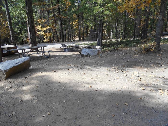
EAGLE CREEK CAMPGROUND Campground
List of CampsitesOverview
Eagle Creek campground is located above Interstate 84 among tall trees. It was the first developed campground in the Forest Service system. Campsites are well-spaced creating a feeling of privacy. It is, however, located on the bluff above Interstate 84 and railroad tracks so it can be noisy.Recreation
This campground is part of the Eagle Creek Recreation Area featuring the classic and popular Eagle Creek trail and access to several other hiking and road biking trails. There are outstanding day hike opportunities with views and wildflowers as well as access to the Mt. Hood National Forest and Mark O. Hatfield Wilderness with extended overnight trips. Boating, river activities, interpretive centers, fish hatcheries, bird watching and picnicking are in this area.Facilities
There are 16 campsites available, each with a paved parking apron and most are fully accessible. There is a central restroom, and faucets for drinking water are scattered throughout the campground. A full-time host is on site.Natural Features
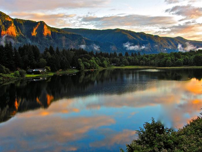
Located in the heart of the Columbia River Gorge National Scenic Area, Eagle Creek campground is situated in a classic Douglas fir and maple forest with osprey nesting overhead. Salmon fishing is popular on the nearby Columbia River.Nearby Attractions
See huge sturgeon and other fish at the underwater viewing area at Bonneville dam and hatchery or take a self-guided tour of the onsite Cascade fish hatchery. Cascade Locks Museum and Sternwheeler are five minutes away to the east. The iconic Multnomah Falls and Columbia River Gorge Historic Highway are a short drive to the west. World-class kite boarding and board sailing are in Hood River, Oregon, about 20 minutes east.WYETH CAMPGROUND Campground
List of CampsitesOverview
Wyeth Campground is just off of Interstate 84 in a forested setting with grassy fields. There are 13 individual sites, three group sites, and a 24-hour camp host. In the past this site was a Seed Kiln, Guard Station, Church camp, Civilian Conservation Corps camp and Conscientious Objector Camp during World War II.Recreation
The Wyeth trail and the Gorge 400 trail access wilderness, waterfalls, the Pacific Crest Trail and dispersed camping opportunities. Fishing, sea kayaking, kiteboarding and windsurfing are nearby on the Columbia River while road biking is available on the Historic Columbia River Highway bike path adjacent to the campground. Please note that the Wyeth Trail #411 is closed indefinitely due to damage sustained during the Eagle Creek fire of 2017.
Facilities
Paved roads, paths and aprons make this site easily accessible to all. The full-time onsite hosts maintain a central flush toilet restroom with hot and cold water. Each site is equipped with picnic tables and fire grills and many sites are fully accessible. There are no RV hookups or dump sites.
Natural Features
Set at the base of classic Gorge cliffs, this historic site features easy access to trails, waterfalls, a bike path and a creek. The Mark O. Hatfield Wilderness and solitude is a short hike from the campground. Osprey and bald eagles reside locally.
Nearby Attractions
Take a hatchery tour 10 miles west at Bonneville Dam, enjoy world-class wind sailing activities 10 miles east in Hood River, tour orchards or see iconic waterfalls in the gorge, all within 45 minutes. Cascade Locks offers Sternwheeler cruises 8 miles west. The Historic Columbia River Highway bike path now runs directly adjacent to the campground and heads east anwestd for a relaxing hike or bike ride to Vieno State Park. See waterfalls along the way!
EAGLE CREEK OVERLOOK GRP SITE Campground
List of CampsitesOverview
Eagle Creek Overlook Group Site is set on a forested bluff above the Columbia River, providing an ideal setting for family gatherings and group events.Developed by the Civilian Conservation Corps (CCC) in the 1930s as a place to view construction of the Bonneville Dam, this site features CCC masonry and offers expansive views of the Columbia River and mountains rising from the gorge.
Recreation
The Eagle Recreation Area, just a short walk or bike ride away, provides visitors with opportunities for picnicking, hiking and wildlife viewing.
Bonneville Dam, about a mile west of the campground, features sturgeon ponds, fish viewing and a visitor's center. Visitors will find display ponds showcasing large rainbow trout and adult white sturgeon measuring more than ten feet long. Interpretive displays offer visitors insight into the history and construction of the dam and its impact on the surrounding areas.
The Eagle Creek Trail* is the most popular trail in the Columbia Gorge, offering spectacular viewpoints and waterfalls. The relatively easy trail follows Eagle Creek through the forest and along paths carved into basalt cliffs. Notable stopping points include Punch Bowl Falls, where water spills 100 feet into a blue-green pool set in a large grotto, High Bridge, which traverses the gorge 150 feet above the creek and Tunnel Falls, where the trail passes through a tunnel behind the shower of falling water. This trail is part of a multi-day loop opportunity which continues into the Mark O. Hatfield Wilderness in the Mt. Hood National Forest.
*Please check the CRGNSA website (https://www.fs.usda.gov/crgnsa) for the latest trail information.
Facilities
The Eagle Creek Overlook Group Site holds up to 90 people and approximately 40 cars, including trailers. There is a train trestle with under-clearance of 11' 6".
The site is equipped with a large covered picnic shelter, picnic tables, campfire rings, drinking water and newly remodeled accessible flush toilets.
A path from the site down the bluff provides access to the Columbia River.
Natural Features
Spanning southern Washington and northern Oregon, from the mouths of Sandy River to the Deschutes River, the Columbia River Gorge is unique in both its natural and cultural history, as well as its designation as a National Scenic Area. It is a spectacular river canyon, 80 miles long and up to 4,000 feet deep, cutting the only sea level route through the Cascade Mountain Range.Nearby Attractions
A portion of the historic Columbia River Highway has been converted to a bike path. Access is just a few minutes from the Overlook and the trail runs 2 miles east to Cascade Locks and 4 miles west to John Yeon State Park.
Visitors may want to traverse at least a portion of the spectacular Pacific Crest Trail (PCT), one of the world's premier National Scenic Trails. This trail showcases some of North America's most fantastic scenery, winding its way its way from Mexico to Canada through California, Oregon and Washington.
Eagle Creek Day Use Area Facility
This historic site is a great accessible spot for a picnic alongside the mouth of the stunning Eagle Creek slot canyon. Today's picnic area was once the site of the first developed campground in the U.S. Forest Service, with facilities that were later rebuilt during the Great Depression by the Civilian Conservation Corps structures. On site remains the famous historic restroom (currently closed) nicknamed "Big John." The 1916 structure was the first flush toilet in the U.S. Forest Service.
Look for the historic Community Kitchen Pavilion perched on the hillside, which is wheelchair accessible. Stone ovens and an old trail register sit on the road to the trailhead. All the site's historic structures were saved by firefighters in 2017, when a massive wildfire known as Eagle Creek Fire started on nearby Eagle Creek Trail #440 (still closed for repairs).
A lovely suspension bridge which once allowed hikers to cross Eagle Creek for the Gorge Trail #400 and Wauna Viewpoint Trail #402 did not fare so well in the fire. Intense heat snapped a cable, causing the bridge to warp, so it was removed to prevent further damage to the downstream hatchery and other infrastructure. The Forest Service is working on plans to replace the bridge but there is no timeline yet for reopening.
Due to post-fire hazards on the landscapes, many other area trails including Ruckel Creek Trail #405 are still closed while crews clear and stabilize trails.
The roads have tight curves, so trailers longer than 20 feet trailer cannot fit into this recreation area.
The paved Historic Columbia River Highway State Trail, great for road biking or a scenic run, runs to the town of Cascade Locks to the east and runs west to connect with the Historic Columbia River Highway Waterfall Corridor (where bikes must share the road with cars).
The state-run Cascade Hatchery is located onsite, offering self-guided tours. During the fall, visitors can view chinook and coho salmon spawning at Eagle Creek. Please protect spawning salmon by looking without touching. Do not throw rocks or poke salmon with sticks and stay out of the creek during spawning season.
Coyote Wall Recreation Area Facility
A massive formation of columnar basalt, Coyote Wall is one of the Columbia River Gorge's most recognizable features from all directions. Known around the Gorge as "The Syncline", local amateur geologists enjoy debating its proper geological classification over a craft brew.
From Coyote Wall Trailhead, bikers, hikers, and riders can access a 30+ mile network trails with an open feel and breath-taking views. Trails include:
- Bitterroot Trail #4422 (Ca2)
- Coyote Wall Trail #4428 (Co1)
- Desert Parsley Trail (Co7)
- Labyrinth Trail #4423 (Co7)
- Little Maui Trail #4425 (Co5)
- Little Moab Trail #4424 (Co3)
- Old Ranch Road Trail #4426 (Co4)
- Raptor Trail 4424 (Ca1)
- Upper Labyrinth Trail #4424 (Co8)
Mountain bikers love the range of mountain biking challenges which reward those who climb the trails with amazing panoramas of the Gorge! Naturalists can appreciate the diverse population of rare and sensitive plants found here. The thin, fragile soils were created by Missoula floods, and the habitat remains important for wildlife species.
Please avoid the area directly below Coyote Wall to the west, as it is private land. Trails in the area have been gradually rehabilitated in recent years according to a long-term site management plan, so user-created trails that once damaged natural resources are being decomissioned. New signs make it easy to stay on official trails, but use maps with caution as most are now out of date. (This planning map shows temporary names used during the planning process to label approved trails.) Today's signs do not match the shorthand codes, but they do make it easy to stay on official trails. Please respect signs indicating decommissioned trails and sensitive areas under restoration.
Wahkeena Falls Facility
Wahkeena Falls is day use area and trail situated at the base of beautiful Wahkeena Falls, just west of Multnomah Falls on the Historic Columbia River Highway. One of stops along the famed waterfall area on the Historic Highway, it connnects with a network of trails that make for great day hike loop opportunities, and world-class scenery. The 242-foot falls is a tiered type of waterfall, named after the Yakama word for "most beautiful". While not as tall as nearby Multnomah, it is no less lovely.
Wakheena Falls and several trailheads are located south of the highway, where an accessible overlook provides a prime view and photo opp for visitors. Nearby trailheads include Wahkeena Trail #420, Gorge #400 Trail, and a short Return Trail that can be used to hike to nearby Multnomah Falls.
Amenities at the picnic area (north of the highway) include a large picnic shelter with a stone fireplace, along with accessible picnic tables and fire rings.
Many people ask about reservations for weddings. This is a first-come, first-served area. If the group will be larger than 75 people, a special use permit is required.
HCRH (US 30) - Waterfall Corridor Facility
By far the most popular segment of the Historic Columbia River Highway, the waterfall corridor runs from Troutdale to Ainsworth.
It can be extremely congested on weekends (think: bumper to bumper) so if you are hoping for a leisurely drive, plan ahead with Ready, Set, Gorge tips on avoiding congestion.
For more information on the Historic Columbia River Highway, visit:
- Oregon Department of Transportation - maps and information on access, road construction, and the reconnection project.
- Oregon Parks and Recreation Department - information on areas closed to vehicle traffic, which are managed as the Historic Columbia River Highway State Trail.
For information about accessible recreation opportunities in Pacific Northwest National Forests, visit http://www.fs.usda.gov/goto/r6/accessiblerecreation
Mark O. Hatfield Wilderness: Columbia Gorge Facility
Mark O. Hatfield Wilderness covers 65,822 acres of basalt cliffs, waterfalls, and lush coniferous forests between Mt. Hood’s northern slope and the sheer cliffs south of the Columbia River. Not far from the only sea-level route through the Cascades, its northern boundary within the National Scenic Area is near a busy transportation corridor, while its southwest boundary is much more remote terrain in Mt. Hood National Forest. Travelers seeking solitude may pass through heavily visited areas within the Columbia River Gorge before the crowds thin, making it critical to practice leave no trace principles and observe the wilderness ethic and regulations.
First designated in 1984, Hatfield Wilderness was expanded in 2009 to include the Gorge Face (from Oneonta Creek west to Viento Creek) and Larch Mountain (Oneonta Creek canyon, Bell Creek, and Multnomah Creek). The main waterways through the area flow north toward the Columbia, through old growth western hemlock and Douglas fir. The wilderness trails that start in the National Scenic Area climb steep drainages to Benson Plateau before continuing on to mountain peaks (4,900-foot Mount Defiance), talus slopes, and high elevation lakes. Those uncomfortable with heights should be aware that these hikes pass steep cliffs and drop-offs. The rewards for trekkers include spectacular views, sparkling waterfalls, and serene old growth forests with mossy-green cliff faces.
Bull Run Watershed, located at the southwest boundary of the wilderness, provides drinking water to the Portland metropolitan area. It is closed to public entry except for the Pacific Crest National Scenic Trail which travels along the watershed’s eastern edge.
Eagle Creek Trailhead & Trail (#440) Facility
This spectacular cliffside hike passes through a forested basalt cliff overlooking Eagle Creek. It affords spectacular views of the creek's slot canyon, where a cool, ethereal fog offers a reprieve on a hot summer day. Small waterfalls trickle along the sides of the cliff, and the trail passes many larger waterfalls, including the iconic Punch Bowl Falls, which is accessed from a side trail about 2 miles up the trail. About 3 miles up, hikers will encounter the aptly named High Bridge, which traverses a narrow gorge 150 feet above the creek. Many hikers choose to backpack as far as Tunnel Falls, about seven miles up the trail, where they can pass behind falling waters.
This is one of the most popular trails in the Columbia River Gorge and can be a crowded experience on summer weekends. Sheer cliffs have no hand rails on parts of this trail, so this hike is not recommended for children or those afraid of heights, despite its gentle overall grade. Please also be mindful of your pets and be sure to wear proper footwear.
In 2017, more than 150 hikers had to be rescued from the Eagle Creek Fire by emergency personnel who assisted them up the remaining 12 miles and 3,000 foot elevation gain to the Wahtum Lake Trailhead. Many shivered through a hungry, exposed night outdoors and shared afterwards that they learned why it's so important to pack overnight essentials, even for a short day hike.
Normally, the trail connects to several other remote, multi-day loop backpacking opportunities in the Mark O. Hatfield Wilderness on the Hood River Ranger District in the Mt. Hood National Forest. It is also a popular alternative route to the Pacific Crest Trail. However, recovery efforts from the 2017 wildfire are still underway, so this network of trails remains closed. If you are hiking overnight, it is recommended that you park your car near the day use host site as it will be more secure there than at the trailhead. Around mile 5, you enter Wilderness where a free permit is required (available at the wilderness boundary).
Download a Trail Description and Map (pdf) *Note this description has not been updated since Eagle Creek Fire and is not currently accurate.
HCRH (US 30) - Mosier to The Dalles Facility
Full of outstanding panoramas, this section of the Historic Columbia River Highway (HCRH) is a delightful drive. The world-famous loops that descend from the Rowena plateau to The Dalles is even a joy to drive on weekends, as its distance from Portland has kept it one of the Gorge's less-discovered secrets. Situated on the east end of the Cascades Range, it looks over a grassland ecosystem and is often sunny when other parts of the Gorge are raining.
Touring cyclists can connect this section of the trail to other trails in the The Dalles region or can continue from Mosier to Hood River on the Twin Tunnels segment of the HCRH State Trail.
HCRH (US 30) - Hood River Facility
This remaining section of the Historic Columbia River Highway (HCRH) can be explored from I-84 exits 62 and 64. It heads past historic hotels and quaint shops and restaurants of downtown Hood River, leading east of town to the Mark O. Hatfield East visitor's center. There, the car-free Twin Tunnels segment of the HCRH State Trail allows bikers and pedestrians to continue to Mosier.
Just west of the interstate, visitors can follow the historic highway past charming gardens of the historic Columbia Gorge Hotel to tiny Ruthon Park, just west of I-84 Exit 62, which offers a picnic spot with great westward view of the Gorge. Shortly afterwards, the old highway simply ends. The last section to be completed will pick up here, and planning is underway to determine the best route around Mitchell Point to connect to the bike/walk path, which picks up again at Viento State Park.
While you are in Hood River, you are always welcome to visit the Forest Service's National Scenic Area office on 902 Wasco Street (open 9-5) to buy maps and passes, or get sightseeing tips.
Upper Labyrinth (#4424) Facility
Located just south of Atwood Road in Klickitat County, Upper Labyrinth Trail connects to Desert Parsley Trail to the east, leading to the Catherine Creek Area. To the west, it links up with Labyrinth Trail, providing spectacular views of the eastern Gorge.
Catherine Creek Loop Facility
This 1.9 mile loop, northeast of the Catherine Creek Trailhead, offers spectacular wildflower viewing during the spring and passes within sight of a natural arch. The vicinity surrounding the arch is closed to protect resources and is marked off by a fence. Please help keep it nice for the next generation, and do not enter the closed area.
At the moment, the trail on the ground is a user-created trail, which was approved for visitor use during the planning process for this site. However, it has not yet been officially built by the Forest Service so it is not signed or maintained according to Forest Service standards.
Watch for poison oak, ticks, and rattlesnakes.
Note: Horses are not permitted on this trail. Dogs must be on leash year round.
Historic Columbia River Highway Facility
Constructed between 1913 and 1922, the original Columbia River Highway was designed to bring travelers to the most breathtaking sights and scenes in the Gorge. From the amazing loops at Rowena plateau to Multnomah Falls, its iconic and innovative design included rock walls, bridges earned it the nicknames "King of Roads" and "A Poem in Stone." It was a new type of motorway bringing automobile adventurers to the Gorge's "beauty spots", and many consider it to be America's first scenic highway.
Structures such as Vista House and Forest Service recreation sites Multnomah Falls and Eagle Creek were developed in conjunction with the highway to connect motorists to the Gorge's natural wonders. Parts of the original roadway were replaced by Interstate 84 in the 1960s, so in 1986 the National Scenic Area designation began a process to reconnect this inspiring pathway.
Thanks to interagency collaboration, the Historic Columbia River Highway (HCRH) State Trail winds through state, federal, and other lands. Travelers can discover waterfalls, vistas, and beautiful bridges as they explore the length of the Gorge, enjoying scenic rest stops along the way. Today, visitors can explore segments of the historic route by driving, biking, or heading out on foot.
Columbia River - Washington Shoreline Access Facility
The Columbia River Gorge Scenic Area is home to one of the most spectacular stretches of the Columbia River, and within our boundaries lie a variety of state, county, and local parks that provide shoreline access from the Washington side. Be sure to check their website for applicable fees, current conditions, and restrictions:
- Beacon Rock State Park. This freshwater shoreline on the Columbia River, maintained by Washington State Parks has strong currents. Visit website >
- Dougs Beach State Park. On the Columbia River, this undeveloped day-use site is a Washington State Park well-suited for advanced windsurfers. Visit website >
- Maryhill State Park. The Columbia River provides opportunities for stand-up paddleboarding, kiteboarding, windsurfing, and other water fun at this Washington State Park. Visit website >
- Spring Creek Fish Hatchery State Park. This Washington State Park offers premier windsurfing and kiteboarding opportunities, with views of Mount Hood. Visit website >
- Stevenson – Bob’s Beach. The City of Stevenson bills this as one of the windiest spots in the Gorge, and a web cam makes it easy to check current conditions. Visit website >
Columbia River - Oregon Shoreline Access Facility
The Columbia River Gorge Scenic Area is home to one of the most spectacular stretches of the Columbia River. These state, county, and local parks provide shoreline access from the Oregon side. Be sure to check the relevant website for applicable fees, current conditions, and restrictions:
- Cascade Locks - Blackberry Beach. This Port of Cascade Locks site is popular with windsurfers and kiteboarders due to a rocky access point to the Columbia River. Visit Website >
- Celilo Park. A small, well established park with shoreline access to the Columbia River maintained by the U.S. Army Corps of Engineers. Visit website >
- The Dalles – Riverfront Park. Managed by North Wasco County Parks and Recreation, this park has a swimming area and river access. Visit website >
- Hood River – Waterfront. World-famous site for windsurfing and kiteboarding areas, this area has designated swimming areas and safety zones. View website >
- Koberg Beach State Scenic Recreation Site. This Oregon State Park is home to a launch site hidden from the nearby busy freeway by a great rock. Visit website >
- Lewis and Clark State Park. One of the most popular swimming spots on the Sandy River is adjacent to this Oregon State Park. Visit website >
- Mosier -- Mayer State Park. This Oregon State Park’s rocky shore offers swimming, boating, fishing and picnicking. Visit website >
- Rooster Rock State Park. This Oregon State Park features swimming, windsurfing and kiteboarding, and a clothing optional beach. Visit website >
- Viento State Park. This Oregon State Park has a day-use area with easy access to the Columbia River and some of the best windsurfing in the Gorge. Visit website >
Mt. Hood Scenic Byway Facility
Visit two amazing Forest Service sites in one day on this scenic byway, which runs through Mt. Hood National Forest and ends in the Scenic Area. Explore the route with this printable map or visit the Travel Oregon's website for an extended write-up.
Dog Mountain Trail System Permits Ticket Facility
Overview:
Springtime wildflower blooms and stunning views make Dog Mountain one of the most popular hiking areas in the Columbia River Gorge National Scenic Area. Visitors can enjoy panoramic views of the Columbia River Gorge and Mount Hood towering to the south. The popular Dog Mountain - Augspurger loop is a strenuous 6.8-mile hike that climbs 2,828 feet. Approximate hiking time is three to six hours. The area provides opportunities for several shorter hikes as well. Visitors can expect crowded conditions along the trail on weekends during the wildflower season.A Dog Mountain Trail System Permit is required March 31st through July 1st (Saturday and Sunday only). Each permit allows one individual one day of use on the Dog Mountain Trail System. Individuals can purchase up to four permits (per day), as available. The permit is only valid for the date reserved. The permit does not guarantee a parking space at Dog Mountain Trailhead. Permits are not required July 2nd through March 30th.
There is a $1.50 non-refundable reservation fee per permit. If you decide not to use your permit, please cancel your reservation in order to make space for others. Dog Mountain Trailhead is a recreation fee site and a daily, per-vehicle recreation fee of $5.00 is charged for use of the trailhead facilities. This is in addition to the reservation fee. Visitors can pay the recreation fee on-site or online at https://yourpassnow.com/parkpass. Annual passes such as the Northwest Forest Pass and other interagency senior, military, and Every Kid in a Park passes are accepted as alternate forms of payment.
