
Malheur National Forest
Camping Facts and Guidelines
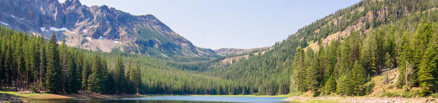
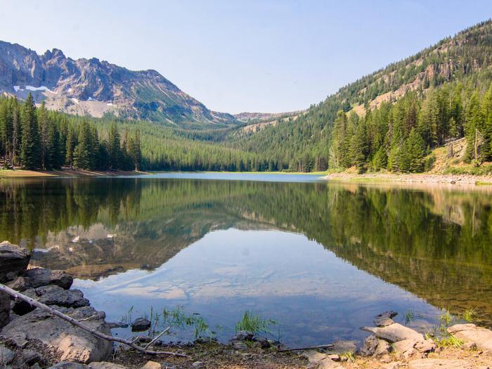
Malheur National Forest Campground Brochure
- There is no fee for day use on the Malheur National Forest
- There is a 14 day camping limit in developed sites (developed campgrounds)
- A 30 day stay limit is in place for dispersed sites (non-developed campgrounds)
- All campgrounds are first come first serve except for the group camping site at Magone Lake. Reservations can be made at https://www.recreation.gov/
Dispersed Camping
Many people enjoy the solitude and primitive experience of camping away from developed campgrounds and other campers. Dispersed camping is the term used for camping anywhere in the National Forest outside of a designated campground. Dispersed camping means there are no toilets, no picnic tables, no trash cans, no treated water, and no fire grates. Typically, dispersed camping is not allowed in the immediate vicinity of developed recreation areas such as campgrounds, boat ramps, picnic areas or trailheads. There are extra responsibilities and skills that are necessary for dispersed camping. It's your responsibility to know these before you try this new experience.
RecAreaDirections
Open with Google Map
Misc
| Stay Limit | |
| Reservable | false |
| Keywords | |
| Map Link | |
| Contact Phone | |
| Contact Email |
Permits info
Facilities
SHORT CREEK GUARD STATION Campground
List of CampsitesOverview
Short Creek Guard Station is a great place to stay to enjoy the nearby Monument Rock and Strawberry Mountain wilderness areas, as well as the North Fork of the Malheur Scenic River. The cabin offers access to a variety of recreational activities, including hiking, hunting, fishing and viewing wildlife.The cabin provides all the comforts of a home, including drinking water during the summer months. Guests are responsible for their own travel arrangements and safety, and must bring several of their own amenities.
Recreation
In the warmer months, popular activities include hiking, horseback riding, mountain biking, fishing and wildlife viewing around the cabin and in the nearby wilderness areas and the North Fork of the Malheur Scenic River.There are moderate hiking trails near the cabin, and rugged hiking trails in the wilderness. The wilderness provides over a hundred miles of trails. The riparian habitat of the river lends itself to picnicking, fishing and observing all kinds of wildlife. The wilderness has many wildlife viewing opportunities as well.
Facilities
The kitchen is equipped with a propane cook stove, sink, propane refrigerator, propane lights and a propane heater that heats the entire facility. The small indoor bathroom provides a flush toilet and a shower during summer months only. Additionally, the building is equipped with a propane hot water heater, which provides hot water to the shower and sinks during the summer months only.
A picnic table, two BBQ grills and a fire pit are located next to the building, under the shade of nearby trees.
The cabin has one queen-sized bed in a private bedroom and a large couch in the living room. Guests will need to bring their own bedding (blankets, linens, pillows and/or sleeping bags), as well as flashlights or a lantern for emergencies, a first aid kit, towels, garbage bags and dish soap, among other necessities. The cabin will need to be cleaned and all garbage carried out prior to leaving.
Natural Features
The cabin is situated in a corner of a small meadow surrounded by tall ponderosa pines, at an elevation of about 5,000 feet. It is about 38 miles from the town of John Day, in eastern Oregon.A babbling creek runs alongside the cabin and a variety of wildlife make its home in the area, including elk, deer, antelope, black bears, bighorn sheep, grouse, as well as many species of birds. Nearby, the Monument Rock and Strawberry Mountain wilderness areas, as well as the North Fork of the Malheur Scenic River, offer vast opportunities for exploration.
The Strawberry Mountain Wilderness has an extremely diverse ecological makeup, with five of the seven major life zones in North America and around 378 kinds of animals and approximately 22 fish species.
SUNSHINE GUARD STATION Campground
List of CampsitesOverview
Sunshine Guard Station is situated along John Day River in the Malheur National Forest at an elevation of 3,700 feet, about 43 miles northeast of John Day, Oregon. The former guard station was built in 1936 and until the 1990s was used alternatively as a bunkhouse or a work station for fireguards.The guard station can be accessed by vehicle. Guests are responsible for their own travel arrangements and safety, and must bring several of their own amenities.
Recreation
Recreational options include fishing for steelhead and rainbow trout in the John Day River. Restrictions apply; visitors should refer to Oregon State regulations.
There are hiking trails and back roads to the north of the guard station that lead into the nearby Vinegar Hill / Indian Rock Scenic Area.
Wildlife viewing is popular, as is scenic driving.
Facilities
This rustic four-room cabin sleeps up to six and has a kitchen, living room, and two bedrooms. The living room is furnished with a futon, two chairs, a coffee table and an end table. The larger bedroom is furnished with a queen-sized bed and a closet, while the smaller bedroom offers a queen-sized bed and a chair.
The kitchen is furnished with a table and four chairs, electric refrigerator, and stove. Electric heat and lights are provided, and a vault toilet is located next to the cabin.
There is no water in the cabin. Guests must bring their own water for drinking, cooking and washing.
Roads to the guard station are paved and maintained for summer and winter access.
Natural Features
The guard station has a view of the Middle Fork of the John Day River. The Vinegar Hill Forest/Indian Rock Scenic Area is nearby. The 25,000-acre area includes a 10 mile ridgeline that comprises the summit of the Greenhorn Range in the Blue Mountains of eastern Oregon. Outcrops of serpentine, rhyolite, basalt, granite, and shale can be seen. Agates can also be found on some of the rocky slopes.
Wildlife includes elk and deer, songbirds and, in the river, steelhead and trout. Nearly every type of alpine wildflower found west of the Rockies can be blooming at different times in this area.
Magone Lake is about 20 miles west of the guard station.
DEER CREEK GUARD STATION CABIN Campground
List of CampsitesOverview
Deer Creek Guard Station is located approximately 31 miles from the town of John Day, in central Oregon. It is in a beautiful, quiet location, off the beaten path. From sunup to sundown, the cabin affords opportunities for adventure in exploring, viewing wildlife, or just relaxing and enjoying the wonders of nature all around. The cabin is larger than some, is furnished and offers many comforts. It can be accessed by vehicle. Guests are responsible for their own travel arrangements and safety, and must bring several of their own amenities.Recreation
Big game hunting is popular in the area, as well as fishing on Deer Creek and South Fork John Day. Anglers might watch for coho, winter steelhead, spring chinook, fall chinook and cutthroat trout, among others in the area. Guests can also enjoy hiking and horseback riding on a variety of trails in the area.Facilities
The rustic cabin has a living room/sleeping area, a small bedroom and a kitchen. The living/sleeping area is equipped with a propane fireplace for heat, a couch, chair and end tables. A Murphy bed is located in the living/sleeping area for additional sleeping space and can be put away during the day.In the dining area is a full futon bed and table with four chairs. In a small room just off the dining area is a log bunk bed that can sleep two comfortably. The cabin can accommodate up to six people. The kitchen is equipped with a propane cook stove and propane refrigerator, ample counter space, pots, pans, plates, bowls, cups and flatware. The entire cabin is lit with propane lights.
An accessible vault toilet is located near the guard station. A picnic table and campfire ring are situated next to the perennial creek that runs through the facility grounds. Any water taken from an outdoor source should be boiled or treated prior to consumption. Stream water gets scarce during mid-August. Firewood can be collected from the surrounding area.
Guests should bring their own water for drinking, cooking and cleaning purposes, as well as bedding (linens, blankets, pillows and/or sleeping bags), flashlights or a lantern for emergencies, a first aid kit, towels, garbage bags and dish soap. Guests will need to clean the facility and carry out all trash prior to leaving.
Natural Features
The three-room cabin was built in 1956 and was originally used as a work station by fireguards. Before satellite surveillance systems, fireguards were the smoke chasers who rushed to sites of reported smoke and tried to extinguish the flames. Douglas fir and ponderosa pine trees dot the broad, flat expanse surrounding the cabin, which sits at an elevation of 5,100 feet. Deer Creek runs through the area nearby. In the spring and summer, guests enjoy abundant wildflowers and wildlife in the area, including wild horses, elk, black bears, deer and wild turkeys and other species of birds.Murderers Creek Guard Station Campground
List of CampsitesOverview
Murderer's Creek Guard Station is in the heart of the Malheur National Forest, in central Oregon. It makes an excellent base camp for back country recreating, and is a cozy retreat for a couple and a fun opportunity to imagine the life of the early day forest rangers. The historic guard station is one of the oldest standing buildings in the forest. The cabin contains some modern amenities and can be accessed by vehicle. Guests are responsible for their own travel arrangements and safety, and must bring several of their own amenities.Recreation
Viewing wildlife and birds is popular in the area, as is hunting not far from the facility. Guests can hike area trails, explore the Cedar Grove Botanical Area and fish Murderer's Creek and South Fork John Day, though area creeks run dry toward summer's end.Facilities
The one-room "studio" cabin is equipped with a futon that folds down into a full (double) bed. It has a table and chairs, a propane cook stove, propane refrigerator and propane heater inside the cabin. Basic cooking pots, utensils and tableware are also provided.
There is a garage building and room to park an RV in the adjacent driveway. A newer style vault toilet is located outside.
Guests will need to bring water for drinking, cooking and cleaning purposes, as well as bedding, flashlights or a lantern for emergencies, a first aid kit, towels, garbage bags and dish soap, among other necessities. Guests will need to clean the cabin and carry out all trash before leaving.
Natural Features
The guard station is located approximately 32 miles from the town of John Day. It sits at an elevation of about 5,000 feet. The facility was built in 1913 and was originally used as a fire guard station. It was in use by Forest Service officials until the late 1990s. Murderer's Creek, a small creek that runs east and west along the southern base of Aldrich Mountain, is nearby the cabin. The guard station is surrounded by open meadows and timbered areas of ponderosa pine and mixed conifer. Abundant wildflowers dot the Cedar Grove Botanical Area, a 26-acre cedar grove on the northeast slope of Aldrich Mountain. The area is known for its wild horses, which coexist with mule deer, elk, antelope, bighorn sheep, bear, cougar, and myriad smaller forest animals.FALL MOUNTAIN LOOKOUT CABIN Campground
List of CampsitesOverview
Fall Mountain Lookout Tower is situated about 20 miles from John Day, in central Oregon. It provides 360-degree views of the surrounding Strawberry Mountain Wildness, as well as the towns of Seneca and Mt. Vernon. The lookout offers access to a variety of recreational activities. In addition to sightseeing, visitors to the area enjoy hunting, hiking and viewing wildlife.The lookout can accommodate just two people and provides few amenities. It can be accessed by vehicle. Guests are responsible for their own travel arrangements and safety, and must bring many of their own supplies.
Recreation
Recreational options include wildlife viewing, huckleberry picking, star gazing and hiking the area around the lookout. There is a multiple-use trailhead south of the tower, at Starr Springs. Designated hiking trails into the wilderness are located 30 minutes from the lookout tower by vehicle.Facilities
The one-room, 14-by-14 cabin sits atop an 18-foot tower and sleeps two. The cabin is furnished with a futon bed and a table and chairs. It has electricity and in the kitchen area, an electric stove and refrigerator. The kitchen also contains pots, pans, dishes and tableware.A catwalk encircles the structure, allowing for unobstructed views of the surrounding area. A vault toilet is located near the base of the tower.
There is no water available on site. Guests must bring their own water for drinking, cooking and washing, as well as sleeping bags/bedding, a flashlight or lantern for emergencies, first aid kit, towels, garbage bags, toilet paper and dish soap.
Natural Features
The tower was built in 1933 and sits at an elevation of 5,949 feet. Before satellite surveillance systems, lookout personnel monitored the forest from this 18-foot perch for signs of smoke, alerting fire guards when necessary. Today guests can watch the sun rise and set, spot wildlife from the catwalk and witness dramatic thunderstorms that traverse the territory during summer months.Nearby Attractions
The nearby Strawberry Mountain Wilderness area includes approximately 69,350 acres of land, including mountain peaks and several lakes, as well as the headwaters of Pine, Indian, Strawberry, Canyon, Bear, Lake, Wall, Roberts and Big Creek streams. A variety of wildlife, including elk, mule deer, antelope, black bear, cougar, bighorn sheep, ruffed and blue grouse, pileated woodpecker, sharp-shinned hawk, bald eagle, pine marten, mink and beaver. A varieties of bird and fish can be seen in the area.IDLEWILD Campground
List of CampsitesOverview
Idlewild Campground is the perfect place for large gatherings in any weather. In sun, rain or snow, there are plenty of ways to enjoy the outdoors while spending time with friends and family.The campground is situated along Highway 395 north of Burns, Oregon. In the summer, it is popular with hikers and mountain bikers. In the winter, visitors can snowmobile and cross-country ski.
Recreation
Idlewild offers opportunities for camping, picnicking, hiking and mountain biking. Devine Summit Trail begins within the campground. Snowmobiling and cross-country skiing bring visitors to the area in the winter.Facilities
Idlewild contains one accessible, group day-use picnic shelter available for reservations for up to 75 people. It is equipped with picnic tables, a campfire ring and grills. Vault toilets and drinking water are provided. Individual sites for overnight camping are available on a first-come, first-served basis.Natural Features
The campground is situated at an elevation of 5,000 feet in a large stand of Ponderosa pines. The group shelter sits near a meadow within Idlewild Campground. The Malheur National Forest encompasses 1.46 million acres in the Blue Mountains of eastern Oregon. The forest's dramatic landscapes include the Strawberry Mountain Wilderness, with 9,038' Strawberry Mountain, which extends east to west through the heart of the forest, and the Monument Rock Wilderness along the eastern boundary.Nearby Attractions
The campground is located a short drive from Burns, Oregon. There are horse trails and equestrian camping within 10 miles of Idlewild.MAGONE LAKE Campground
List of CampsitesOverview
Magone Lake Campground is situated along its namesake lake in the northern reaches of Malheur National Forest in the Blue Mountains of eastern Oregon. Visitors enjoy fishing, canoeing, swimming and hiking.Recreation
The Magone Lake area offers swimming, fishing, hiking and mountain biking opportunities. The lake contains eastern brook and rainbow trout. A boat ramp is available on-site. Visitors also enjoy viewing wildflowers and interesting geology throughout the region.Facilities
The campground offers both a picnic shelter and overnight campsite for groups to reserve. These sites can accommodate up to 75 people each. Individual family sites are available on a first-come, first-served basis.Picnic tables and campfire rings with grills are provided, as are vault toilets and drinking water.
Natural Features
The campground is set in a forest of Engelmann spruce and ponderosa pine. Magone Lake covers about 50 acres and features both deep holes of up to 100 feet and shoals on the north side. Geologists believe Magone Lake was created by a landslide in the early 1800s. It is located in the southern reaches of the Malheur National Forest.Monument Rock Wilderness: Malheur Facility
Wilderness Stewardship Performance
At the southernmost edge of the Blue Mountains, this area's alpine, once-glaciated ridges offer views across much of eastern Oregon. The lichen-covered 8-foot cylindrical stone monument atop Monument Rock may have been erected by pioneer sheepherders. This is a new Wilderness in the old landscape of the eastern Strawberry Mountains. Established in 1984 by the Oregon Wilderness Act, the 19,620-acre Wilderness spills from the Malheur National Forest onto the adjacent Wallowa-Whitman National Forest. The northern end of the area lies across a watershed divide that separates drainages of the South Fork Burnt River, as well as two National Forests. The area ranges from about 5,200 feet in the lower regions to the 7,815-foot top of Table Rock.
In the lower lands you will find ponderosa pine, depending on where you go. You may also find lodgepole pine, Douglas-fir, white fir, aspen, and juniper. If you look down, you will probably see elk sedge, pinegrass, wheatgrass, huckleberry, bluegrass, and many wildflowers. As you hike higher, you will find subalpine fir, just below the treeless mountain crests.
The area's diverse wildlife habitat is used by bear, deer, elk, badgers, and the rare wolverine. There are 70 species of birds including the creek-loving water ouzel (American dipper) and the pileated woodpecker. The visiting season here generally runs between June and November. The John Day Valley funnels winter storms and summer thundershowers to the mountain ridges here. As a result the area receives 40 inches of annual precipitation, twice as much as the surrounding, arid lowlands. Summer brings hot days and chilly nights. Hunting is the most popular activity, with hiking and backpacking increasing in popularity.
Strawberry Mountain Wilderness Facility
Wilderness Stewardship Performance
The Strawberry Mountain Wilderness is located east of John Day, Oregon, in the Malheur National Forest. The area includes approximately 68,700 acres and encompasses the headwaters of Pine, Indian, Strawberry, Canyon, Bear, Lake, Wall, Roberts, and Big Creek. The area is dominated by the Strawberry Mountain Range with the highest point being Strawberry Mountain. This area has extremely diverse ecological makeup. Five of the seven major life zones in North America can be found here. It also supports native population of Rocky Mountain Elk and other wildlife. The additions including the Canyon Creek Research Natural Area have improved both the quantity and the quality of the wilderness experience.
The complex geological story of this landscape began millions of years ago with the buckling of an ancient sea floor beneath the area where the western part of the Strawberry Range now rises. Much later, volcanic ash and lava formed the eastern part of the range. Most recently, the glacial ice carved its classic signature--U-shaped valleys--into the mountains. The ice also hollowed out the rock beds that today hold the seven alpine lakes of the Strawberry Mountain Wilderness--rare pleasures in the arid wilderness experience.
In a normal year, most people use the Wilderness between July and November. Snow may be encountered at higher elevations any time of the year. The climate from September is mostly mild, with clear skies. Summertime thunderstorms may occur, usually in cycles lasting several days. Daytime temperatures normally range between 30 and 80 degrees Fahrenheit; nights are cool. Freezing temperatures can occur any time of the year. When you go to the Strawberry Mountain Wilderness, be prepared for hiking in the high country. The land is rugged, and elevations range from 4,000 to the 9,038-foot summit of Strawberry Mountain. Over a hundred miles of trails cross the wilderness, offering vista after vista to the enterprising hiker.
Vinegar Hill Indian Rock Scenic Area Facility
Located in the northeast part of the Forest, this high elevation area provides spectacular vistas of the North Fork John Day Wilderness, the Middle and North Fork drainages of the John Day River, and the peaks of the Strawberry Mountain Wilderness to the south. The area has a rich history and active and decaying remains of mines can be seen. The area provides unfettered opportunities for solitude and isolation except during big-game hunting seasons.
Buckhorn Meadows Trailhead Facility
Provides access to: Buckhorn Meadows Trail #205 which accesses Strawberry Mountain Wilderness.
This trailhead offers undeveloped camping with a 6 horse tie-stall, manger and stock rail. The parking area is small. Please park in a manner that will allow others to turn around in the limited space that is available. Please do not park or drive in the nearby meadow.
Davis Creek West Trailhead Facility
The roads to the western trailhead is very rough and not recommended for passenger vehicles. This trailhead can be a great point for being dropped off, allowing the visitors to hike, bike, motor bike to the connecting trailhead where a pickup vehicle can be staged to meet after the hike or ride. The trailhead is for the Davis Creek Trail #244, this trail is very rocky and rugged and is recommended for more experienced riders.
East Davis Creek Trailhead Facility
This trailhead provides access to Davis Creek Trail #244. There is a flat area for dispersed camping near trailhead. The trailhead is a beautiful spot with ponderosa pine. Visitors to the area will see wildflowers in the spring and early summer, wildlife throughout the year.
Head O' Boulder Forest Camp Facility
This rustic camp offers a few sites and is also a trailhead which accesses the Vinegar Hill-Indian Rock Scenic Area. From the trailhead visitors can access other trails such as the Princess trail #251, Sunrise Butte Trail #255 and Blackeye Trail #243. Allowing for multiple opportunities for hiking.
McClellan Trailhead Facility
This trailhead accesses the nonmotorized McClellan Mountain Trail, #216. The trail is in a semi-primitive roadless area allowing hikers a great place to get away and enjoy a quiet place to hike. The trail leads hikers to Fields Peak as well as McClellan Mountain and connects over to the Riley Creek Trail #216A.
Skyline Trailhead Facility
Provides eastern access to SkylineTrail #385 which enters Strawberry Mountain Wilderness. The trailhead does have parking for horse trailers. The Skyline Trail is a great starting point for those wishing to day hike or backpack into the Strawberry Mountain wilderness.
Starr Sno-Park Facility
This state sponsored Sno-Park provides parking near the west end of the Forest's snowmobile trail system. Located on the south side of beautiful Canyon Mountain visitors will find miles of groomed snowmobile trails to enjoy.
Swick Old Growth Interpretive Site Facility
Established in an old growth ponderosa pine stand, this area includes a short barrier-free trail with interpretive signs, longer trail through additional old growth area, a parking area, picnic table and barrier free toilet. The trail allows visitors to learn about old growth ponderosa pine stands first hand while enjoying a beautiful, easy hike.
Big Creek/Snowshoe Trailhead Facility
This trailhead provides access to Big Creek Trail #377 which enters Strawberry Mountain Wilderness and many other trails. Offering opportunities for both day hiking and backpacking trips.
Horse facilities provide a convenient jumping off point for access to the Strawberry Mountain Wilderness. The trailhead and trail see the highest usage during big game hunting seasons.
Huddleston Snowpark Facility
This Oregon State Sno-Park is the hub of the hundreds of miles of groomed snowmobile trails and access to ungroomed areas on the Forest. There is a cozy warming hut with fireplace and a restroom as well as a large, plowed parking area suitable for vehicles with trailers. It is maintained in partnership with Grant County Snoballers and Grant County. Please show your appreciation for their efforts by respecting the property and helping to keep it in good condition.
Crane Crossing Facility
This is a small rustic camp area near the North Fork Malheur Wild and Scenic River. This site is a great get away for those looking for something quiet and out of the way. The camping area sets just at the trailhead. The trail can be taken to the west and go along the Crane Creek trail or north and head up to the North Fork Malheur trailhead.
Old West Scenic Bikeway Facility
Come explore Oregon's Wild West via bicycle, motor bike, car, truck, horse or foot. This174 mile paved scenic tour takes you through the John Day Valley, John Day Fossil Beds and northern most Malheur National Forest. The state and county roads which make up the Old West Scenic Bikeway offer travelers a journey through, up and over, the Malheur National Forest and surrounding rural communities. You will find many access points, campgrounds, trailheads and views of the Malheur National Forest along the way.
Most cyclists will find this route challenging with two substantial, extended climbs along route with a total gain of 8,493 feet. Most cyclists will require a minimun of two to three days for travel time. Many federal, state, and local camping opportunities are found along the way. For more information on the Old West Scenic Bikeway visit http://rideoregonride.com/road-routes/old-west-scenic-bikeway/
Download the route's GPS data here.
Little Crane Campground Campground
List of CampsitesSmall, four site, campground with stream fishing and great solitude. Campground is located of the Forest Service 16 Rd. and is located over 5500'.
The Campground is managed by the Prairie City Ranger District (541.820.3800). Drinking water and accessible features are not available at this campground.
East Fork Canyon Creek Trailhead Facility
This trail provides access to East Fork Canyon Creek Trail #211 which accesses Strawberry Mountain Wilderness.
There is plenty of room for parking and undeveloped camping at this site. It includes a 6 horse tie-stall with manger, unloading ramp, and hitch rail. Stock water is located 1/2 a mile down the trail on the East Fork of Canyon Creek.
This trail accesses the Canyon Creek Natural Area -- a unique park like stand of old growth ponderosa pine within Strawberry Mountain Wilderness. This trail offers both low and high elevation life zones to explore. The first 1/2 mile of the trail heads slightly downhill across some rocky areas. The rest of the trail has a fairly gentle grade, and it is not very rocky; it is mostly dirt and pine needle surface. There is a wide variety of campsites along this trail.
The trail passes through magnificent old growth Ponderosa Pine, Grand Fir and Western Larch (Tamarack) also take note of the Alder, Sedges and other wetland plants. There are some interesting wet meadows in the first couple of miles of the trail.
East Fork Canyon Creek offers good native cutthroat trout fishing.
