
Mt. Hood National Forest
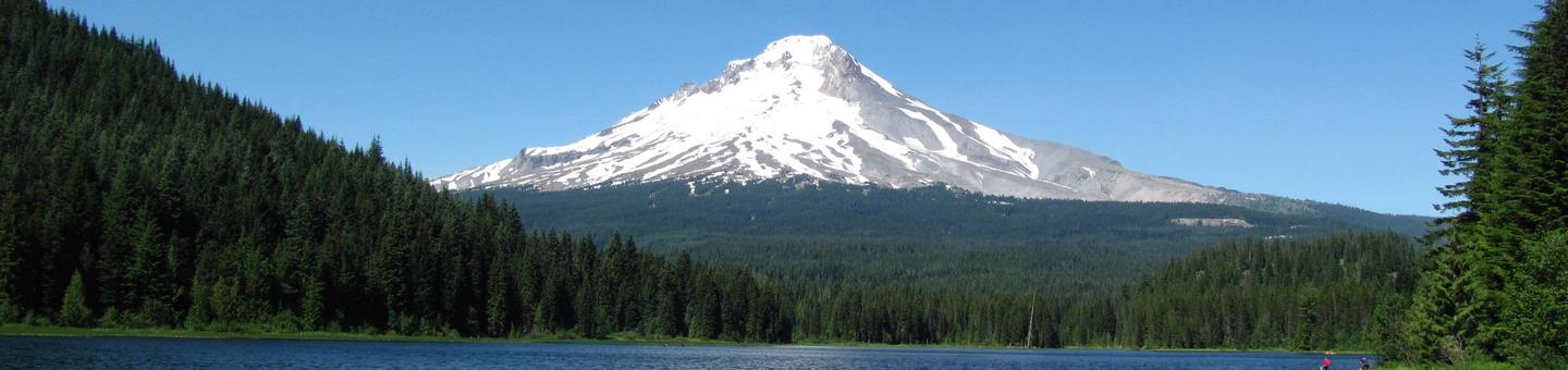
Mt. Hood National Forest offers a huge variety of world-class recreational activities with opportunities for everyone. Mt Hood National Forest encompasses eight unique Wilderness areas as well as multiple barrier free accessible sites to explore. Whether it's skiing, hiking, boating, rafting, climbing, backpacking, horseback riding, or fishing that you are hoping to experience, you're sure to find great opportunities in your National Forest.
Camping in one of our developed campgrounds is a wonderful way to enjoy the forest. For reservations visit recreation.gov. Visit Portland General Electric for reservations at Lake Harriet or Timothy Lake.
 |
 |
 |
 |
 |
Recreation Map
A forest map showing recreation sites.
Know Before You Go
- Review Safety Information
- Check Alerts and Notices, Roads, Weather
RecAreaDirections
Open with Google Map
Misc
| Stay Limit | |
| Reservable | false |
| Keywords | |
| Map Link | |
| Contact Phone | |
| Contact Email |
Permits info
Facilities
TRILLIUM Campground
List of CampsitesOverview
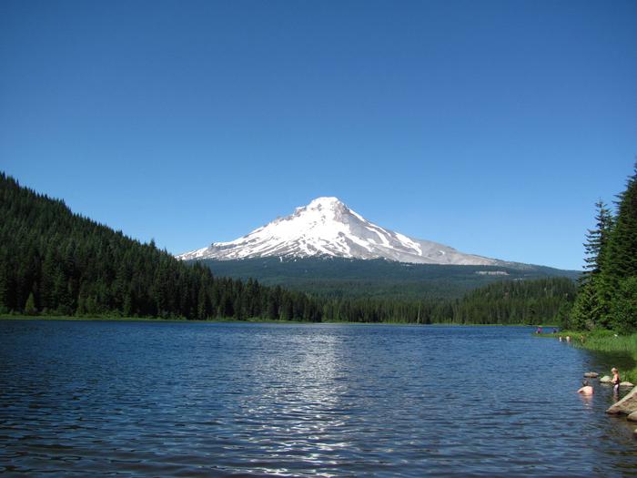
Trillium Lake Campground is a beautiful and popular campground not far from the quaint town of Government Camp. It provides spectacular views of majestic Mt. Hood, Oregon's highest point. The campground is well-known for its scenery and abundant recreational opportunities, as well as being a great, family-friendly place to camp.Recreation
Boating, swimming and fishing are popular on 63-acre Trillium Lake. A small boat ramp is available within the campground and a larger ramp is available in the nearby day-use area. An accessible fishing pier is also available. Anglers cast for a variety of trout.The 2-mile Trillium Shoreline Trail circles the lake, and parts of it are accessible. Visitors also enjoy hiking and biking on other trails in the vicinity. Tours of the area's historical sites are also popular.
Facilities
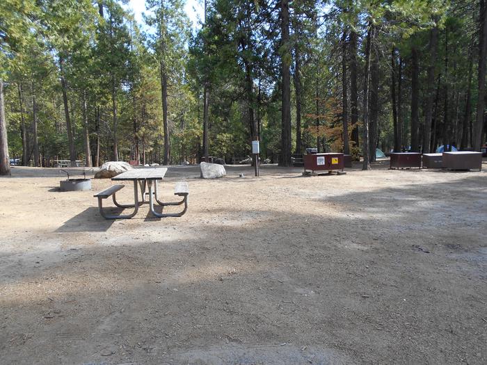
The campground offers dozens of single and double sites for tent and RV camping. Some first-come, first-served sites are available, as well as some fully accessible sites. Parking surfaces are mostly paved, but some are gravel.Each site is equipped with a table and campfire ring with grill. Accessible vault toilets and drinking water are provided. An accessible picnic shelter is adjacent and can accommodate up to 30 people. Parking is available.
An accessible amphitheater within the campground can be reserved for day use and can accommodate up to 30 people. Educational programs are held on weekends throughout the summer.
Natural Features
The campground is located about 40 miles southeast of Portland, in the Mt. Hood National Forest. It sits alongside Trillium Lake at an elevation of 3,600 feet, and is nestled in a shady, mixed conifer forest that provides privacy between campsites.Nearby Attractions
Timberline Lodge, a National Historic Landmark on Mt. Hood, is located within 10 miles of the campground.RILEY HORSE CAMPGROUND Campground
List of CampsitesOverview
Riley Campground is an equestrian facility located northwest of Oregon's majestic Mt. Hood. Horse corrals are tucked into the forest near the campsites, and several horseback riding trails can be accessed from the campground. A variety of recreational and sightseeing opportunities are available for visitors to enjoy.Recreation
Several hiking, biking and horseback riding trails can be accessed from the campground, including the 5.3-mile Cast Creek Trail, which was reconstructed in 1998 and leads from the campground to the Zigzag Mountain Trail. Combined with the nearby 4.9-mile Horseshoe Ridge Trail and part of the Zigzag Mountain Trail, visitors can make a nearly 14-mile excursion. The Sandy River Trail follows the river and stretches about 3 miles.Fishing is available in nearby Lost Creek, as well as the Sandy River, which is not far from the campground. Anglers can expect a variety of trout, salmon and whitefish. The rivers are popular for fly fishing. Scenic drives and picnicking are also popular activities.
Facilities
The campground offers single-family equestrian campsites. Most of the sites are equipped with horse corrals or cross rail hitching posts, tables and campfire rings with grills. Accessible vault toilets and drinking water are provided. Horse owners are responsible for cleaning up after their horses.The campsites are intended for equestrians, but may be used by others. McNeil Campground (1/4 mile away) and Lost Creek (1 �½ miles away) are good alternative sites for those without horses. McNeil does not accept reservations. Horse corrals or hitching racks are provided at the sites.
Natural Features
The campground is situated in the Old Maid Flat geologic area of Mt. Hood National Forest at an elevation of about 2,100 feet. It sits alongside Lost Creek and is near the Sandy Wild and Scenic River. A variety of wildlife makes its home in the area.Nearby Attractions
A deviation from the road coming into the campground (Forest Road 1825), will lead to a trailhead for spectacular Ramona Falls, on the Sandy River. The 7.1-mile, moderately difficult trail leads to cascading waterfalls and is one of the most popular hikes in Mt. Hood National Forest.STILL CREEK Campground
List of CampsitesOverview
Still Creek Campground lies in the shadows of majestic Mt. Hood, in Oregon's Mt. Hood National Forest. It is one of the closest campgrounds to the mountain, and offers access to a variety of recreational opportunities. The surrounding area contains hiking, mountain biking and horseback riding trails, as well as numerous mountain lakes, rivers and creeks.Recreation
A variety of hiking, mountain biking and horseback riding trails can be accessed from the campground, including the historic Barlow Trail. The somewhat primitive, 1-mile trail connects the campground with the town of Government Camp.Fly-fishing is a popular activity on Still Creek. Anglers can expect a variety of trout and occasional whitefish and salmon.
Facilities
The campground offers more than two dozen single-family sites for tent and RV camping. Utility hookups are not provided and parking surfaces are an assortment of dirt, gravel and paved. Water disposal sites are scattered throughout the campground.Sites are equipped with tables and campfire rings with grills. Accessible vault toilets and drinking water are provided. Firewood is available for purchase at or near the campground.
Natural Features
The campground sits on the banks of Still Creek just south Mt. Hood at an elevation of about 3,700 feet. It is surrounded by a lush forest of mixed conifers, including cedar, pine and fir trees. A dense understory of shrubs makes for ample privacy between sites. The creek can be heard throughout the campground.Nearby Attractions
A fork on Forest Road 1825 that accesses the campground will lead to the trailhead for spectacular Ramona Falls on the Sandy River. The 7.1-mile, moderately difficult trail leads to cascading waterfalls and is one of the most popular hikes in the Mt. Hood National Forest.Timberline Lodge, a National Historic Landmark on Mt. Hood, is located within seven miles of Still Creek Campground. Sightseeing and a variety of recreational opportunities are available. The area is a popular snow sports playground for most of the year.
TOLLGATE Campground
List of CampsitesOverview
Tollgate Campground is one of the most convenient to Portland, making it a great headquarters for exploring the Mt. Hood area. It stands in the southwestern shadow of Oregon's highest point, Mt. Hood. The campground provides access to a variety of trails, as well as historic sites, including spots along the famed Oregon Trail.Recreation
A variety of hiking, mountain biking and horseback riding trails are available in the area. The nearly 10-mile Pioneer Bridle Trail passes through the campground. A replica of the original Barlow Road tollgate is just east of the campground. The gate was used by travelers along the Oregon Trail from 1879 to 1919.A day-use picnic area at the campground, providing access to the scenic surroundings, as well as the nearby river and Camp Creek. Anglers enjoy the sport of catch-and-release fishing for small trout and whitefish.
Facilities
The campground offers single-family sites for tent and RV camping. Parking surfaces are dirt and gravel and sometimes uneven. Each site is equipped with tables and campfire rings with grills. Accessible vault toilets and drinking water are provided.An adjacent picnic shelter can be reserved for day use and can accommodate up to 30 people and 10 vehicles. It is equipped with multiple tables and pedestal grills.
Natural Features
The campground is located in the Mt. Hood National Forest, approximately 32 miles southeast of Portland, at an elevation of about 2,100 feet. The campground sits on the north bank of the Zigzag River, just east of the community of Rhododendron, in a humid, semi-subtropic environment of Douglas fir and cedar trees.Tollgate Campground was originally constructed by the Civilian Conservation Corps, and some historic features, such as rock fireplaces and a reconstructed picnic shelter still remain.
Nearby Attractions
The campground is 2.5 miles from the town of Zigzag, which offers a variety of services, including lodging, eateries and a variety of shops.CAMP CREEK Campground
List of CampsitesOverview
The Camp Creek Campground sits next to a babbling forest creek in the country's scenic Pacific Northwest region. The campground is not far from the base of the majestic, snow-covered Mt. Hood, Oregon's highest point and a prominent landmark of the area. A variety of recreational activities surround the campground, including hiking, biking and horseback riding trails, scenic views and points of exploration.Recreation
Surrounding the campground are a variety of hiking and mountain biking trails, including the 1.6-mile Still Creek Trail, which is family-friendly and full of beautiful vegetation, and the Pioneer Bridle Trail, which takes hikers, bikers and horseback riders through about 10 miles of scenic wilderness.Visitors to the area also enjoy mountain biking along the nearby Zigzag River, however bikes are not allowed within designated wilderness areas along the trail.
A variety of trout and whitefish populate the nearby creek and river, where anglers typically enjoy catch-and-release fishing. Wading is also popular in the cool mountain waters. The plentiful creeks and streams in the area stem from glaciers atop Mt. Hood.
Facilities
The campground offers about two dozen single-family and double occupancy campsites, available for tent and RV camping.Each site is equipped with tables and campfire rings with grills. Accessible vault toilets and drinking water are provided. Parking surfaces are dirt and gravel, and a dump station is available nearby for a fee.
Natural Features
The shady and quiet campground is situated on a bench above Camp Creek, in the Mt. Hood National Forest, at an elevation of about 2,200 feet. It is tucked in among a mature forest of Douglas fir and cedar trees that are covered in moss.The campground was originally constructed by the Civilian Conservation Corps in 1936. While updates and renovations have been made, some features from the era remain, such as several stone fireplaces.
Nearby Attractions
The town of Rhododendron is about 3 miles from the campground, offering a variety of services and supplies.LOST CREEK Campground
List of CampsitesOverview
Lost Creek Campground is a fully accessible campground allowing anyone access to campsites, fishing and a paved nature trail that meanders through the area. The campground is also near the Wild and Scenic Sandy River and not far from the popular Ramona Falls Trailhead. Mt. Hood is just southeast of the campground and is close enough for visitors to enjoy a day trip and sightseeing.Recreation
A variety of trails exist within and near the campground, including the accessible Lost Creek Nature Trail, which explains events in history that helped form the area's geology. A deviation from the road coming into the campground (Forest Road 1825), will lead to a trailhead for spectacular Ramona Falls on the Sandy River. The 7.1-mile trail leads to cascading waterfalls and is one of the most popular hikes on the forest.Fishing is available in the Sandy River and anglers can expect steelhead year-round, Coho salmon in the fall and Chinook salmon from February through October. Trout also inhabit the river. Scenic driving and picnicking are popular activities as well.
Facilities
The campground is fully accessible and provides a variety of single, double and walk-to campsites. Two yurts are available for reservation as well. The structures can accommodate up to six campers each. Visitors must provide their own bedding.Picnic tables and campfire rings with grills are provided, as are accessible vault toilets and drinking water. Utility hookups are not available. Firewood is available for purchase from the campground host.
Natural Features
Moss and shrubbery covers the ground and evergreens tower overhead, providing ample shade for the campground and privacy between the individual and group campsites. The campground is situated in the Old Maid Flat area of Mt. Hood National Forest, northwest of majestic Mt. Hood at an elevation of about 2,600 feet. It sits on one of the largest pyroclastic volcanic mudflows from Mt. Hood's "Old Maid" eruption in the 1700s.Nearby Attractions
The town of Government Camp is located at the base of Mt. Hood, about 18 miles from the campground. Year-round skiing is available there, as well as a variety of activities and amenities.FISH CREEK (OR) Campground
List of CampsitesOverview
Campground closed due to the 2020 Riverside Wildfire
Fish Creek Campground is ideally located next to the Clackamas Wild and Scenic River in Mt. Hood National Forest. It provides access to some of the area's greatest whitewater, as well as a famous place to fish. Whether it is relaxation or expansive exploration, there's something for everyone at Fish Creek.
Recreation
Fishing is very popular on the Clackamas and anglers can expect to find winter steelhead, spring chinook and late summer coho salmon, as well as other species of freshwater fish. A convenient boat ramp is available within the campground.The Clackamas River also provides miles of wild water as it bends through the scenic Cascade Range, creating prime whitewater rafting opportunities.
A hiking trail follows the river north and south and begins within the campground. Scenic driving is available on the West Cascades Scenic Byway, which follows the river.
Facilities
The campground offers single-family sites for tent or RV camping. Narrow roads within the campground make for tricky navigation for larger RVs.Each campsite is equipped with a table and campfire ring with grill. Accessible vault toilets and drinking water are provided, but utility hookups are not available. Parking surfaces are gravel.
Natural Features
The campground is situated along a scenic bend just above the river at an elevation of about 900 feet. It is in a heavily forested area, with a variety of bushes, ferns and grasses covering the forest floor. Vegetation provides minimal privacy within the campground, but with the river so close, noises within the campground are fairly muffled.The river provides habitat for the federally protected bald eagle and northern spotted owl, as well as the occasional peregrine falcon. A variety of wildlife also makes its home in the area.
Nearby Attractions
The campground is located about an hour's drive from majestic Mt. Hood, Oregon's tallest point.Riverside (Mt. Hood National Forest, OR) Campground
List of CampsitesOverview
Campground closed due to the 2020 Riverside Wildfire
Riverside Campground is a charming and rustic campground, situated alongside the Wild and Scenic Clackamas River in Mt. Hood National Forest. It provides access to a variety of hiking, mountain biking and horseback riding trails and is a great place to experience nature.
Recreation
Fishing is very popular in the Oak Fork and anglers can expect a catch of winter steelhead, spring Chinook and late summer Kokanee salmon, as well as other species of freshwater fish. The Clackamas River also provides miles of wild water as it bends through the scenic Cascade range, making whitewater rafting a popular activity.The 5-mile Riverside National Recreation Trail, popular for hiking and mountain biking, is located not far from the campground. The surrounding area provides numerous additional opportunities for hiking.
Facilities
The campground offers more than a dozen single-family sites for tent and small RV camping. Each site is equipped with a table and campfire ring with grill. Accessible vault toilets and drinking water are provided, but no hookups are available. Parking surfaces are paved and gravel.Natural Features
The campground is located in Mt. Hood National Forest along the Oak Grove Fork of the Clackamas River at an elevation of about 1,400 feet. Huge maple and Douglas fir trees cover the area, and dense shrubbery provides some privacy between campsites. The campground is not far from the Ripplebrook Ranger Station and Ripplebrook Pond.The river provides habitat for the federally protected bald eagle and northern spotted owl, as well as an occasional peregrine falcon. A variety of wildlife makes its home in the area.
Nearby Attractions
Bagby Hot Springs is located about 14 miles southwest of the campground. A popular site for soaking and relaxing, the springs are in a heavily wooded area in the scenic Cascade Range. The available bathhouses are fed by three major hot water springs and several minor outlets in the area. A historic guard station was built there in 1913.LAZY BEND Campground
List of CampsitesOverview
Campground closed due to the 2020 Riverside Wildfire
Lazy Bend Campground sits next to the Wild and Scenic Clackamas River, close to the city of Estacada. The adjacent river provides countless opportunities for rafting, kayaking, fishing and swimming. The lush, green campground is comfortable for individuals and families who want to escape into nature in Oregon's Mt. Hood National Forest.
Recreation
Fishing is very popular on the Clackamas River. Anglers can expect a catch of winter steelhead, spring Chinook and late summer Coho salmon, as well as other species of freshwater fish.The Clackamas bends and drops through the scenic Cascade Range and offers famous whitewater rafting opportunities. The Upper Clackamas Whitewater Festival is held annually in May and attracts rafters from all over the country.
A hiking trail follows the river north and south and begins at nearby Fish Creek Campground. A boat ramp is also available there. Scenic driving is available on the West Cascades Scenic Byway, which follows the river.
Facilities
The campground offers single-family sites, most of which are designated for tent camping only. A few RV sites are available within the campground, though large RVs are not recommended and no hookups are available.Each site is equipped with a table and campfire ring with grill. Accessible vault toilets and drinking water are provided. Some sites are available on a first-come, first-served basis.
Natural Features
The campground is the forest's westernmost campground, situated at an elevation of 800 feet. It lies between the river and the adjacent highway, nestled among a dense stand of trees. Huckleberry bushes can be found throughout the region.The forest provides habitat for the federally protected bald eagle and northern spotted owl, as well as an occasional peregrine falcon. A variety of wildlife makes its home in the area.
Nearby Attractions
North Fork Reservoir is just over 5 miles northeast of the campground. Boating and other water-related recreation opportunities are available there.The campground is 10 miles from Estacada, which offers a variety of dining and shopping options, groceries and fuel.
LOCKABY Campground
List of CampsitesOverview
Campground closed due to the 2020 Riverside Wildfire
Lockaby Campground is ideally located next to the Wild and Scenic Clackamas River in the lush, green mountains of northern Oregon. It provides access to some of the area's greatest whitewater rafting, as well as a famous place to fish. Whether it is relaxation or recreation, there's something for everyone at the campground.
Recreation
Fishing is very popular in the Clackamas River and anglers can expect a catch of winter steelhead, spring Chinook and late summer Coho salmon, as well as other species of freshwater fish. The Clackamas contains miles of wild water as it bends and drops through the scenic Cascade Range, creating prime whitewater rafting opportunities.A hiking trail follows the river north and south and begins about a mile away at Fish Creek Campground. Scenic driving is also available on the West Cascades Scenic Byway, which travels alongside the river.
Facilities
The campground offers more than two dozen single-family sites for tent and RV camping, though RVs over 16 feet are not recommended due to the steep terrain within the facility. Each site is equipped with a table and campfire ring with grill. Accessible vault toilets and drinking water are provided, but no hookups are available. Parking surfaces are paved and gravel.Natural Features
The campground is situated along the river at an elevation of about 900 feet in Mt. Hood National Forest. Most campsites are within a dense stand of cedar trees overlooking the river. Sites are fairly close together and there is very little vegetation on the forest floor.The forest provides habitat for the federally protected bald eagle and northern spotted owl, as well as an occasional peregrine falcon. A variety of wildlife makes its home in the area.
Nearby Attractions
A boat ramp is available at Fish Creek Campground, which is less than a mile south of the campground. It provides a convenient river launch for kayaks, canoes and rafts.Just below nearby Indian Henry Campground, the Clackamas River offers 12.5 miles of class III-IV whitewater. The Upper Clackamas Whitewater Festival is hosted annually in May, attracting rafters from all over the country.
ARMSTRONG Campground
List of CampsitesOverview
This campground will remain closed due to the 2020 Riverside Wildfire
Armstrong Campground is a small but beautiful place to camp, right on the edge of the Clackamas Wild and Scenic River. The river flows right by spacious, lush, family-friendly campsites, giving visitors plenty of access to the river, as well as to the surrounding forest.
Recreation
Fishing is very popular in the Clackamas River and anglers can expect a catch of winter steelhead, spring chinook and late summer coho salmon, as well as other species of freshwater fish. The Clackamas contains miles of wild water as it bends and drops through the scenic Cascade Range, creating prime whitewater rafting opportunities.A hiking trail follows the river north and south and begins about a mile away at Fish Creek Campground.
Facilities
The campground offers single-family sites available mostly for tent camping, but a few sites having space for RVs. Larger RVs may have trouble navigating the roads within the facility. An overflow parking area is available.Each site is equipped with a table and campfire ring with grill. Accessible vault toilets and drinking water are provided. No hookups are available. Parking surfaces are gravel and dirt.
Natural Features
The campground is located in Mt. Hood National Forest at an elevation of about 870 feet. A variety of ferns, shrubs and grasses cover the forest floor and provide some privacy between sites. While the campground is close to the road, the sound of the river blocks most of the noise.The forest provides habitat for the federally protected bald eagle and northern spotted owl, as well as an occasional peregrine falcon. A variety of wildlife makes its home in the area.
Nearby Attractions
A boat ramp is available at Fish Creek Campground, which is less than half a mile south of the campground. It is a convenient place to launch kayaks, canoes or other boats on the river.Just below Indian Henry Campground, the Clackamas River offers 12.5 miles of class III-IV whitewater. The Upper Clackamas Whitewater Festival is hosted annually on the river, attracting rafters from all over the country.
RIPPLEBROOK Campground
List of CampsitesOverview
Campground closed due to the 2020 Riverside Wildfire
Ripplebrook Campground is a charming facility for nature enthusiasts and lies in a beautiful forest setting. Fly fishing and whitewater rafting are popular near the campground, as it neighbors the Clackamas Wild and Scenic River. The small facility is geared more toward tent camping, however, tent trailers and RVs under 19 feet are welcome.
Recreation
Fishing is very popular in the Clackamas River and anglers can expect a catch of winter steelhead, spring chinook and late summer kokanee salmon, as well as other species of freshwater fish. Whitewater rafting is also a favorite pastime. The Clackamas provides miles of wild water as it bends through the scenic Cascade Range.The 5-mile Riverside National Recreation Trail, popular for hiking and mountain biking, is located not far from the campground. The surrounding area provides numerous additional trail opportunities.
Facilities
The campground offers single-family sites for tent and small RV camping. Each site is equipped with a table and campfire ring with grill. Accessible vault toilets are provided. Utility hookups are not available. Parking surfaces are paved and gravel.Natural Features
The campground borders the Oak Fork of the Clackamas River in a dense forest of mature maple, cedar and fir trees. Large shrubs and ferns blanket the forest floor, providing privacy between campsites. The campground is situated at an elevation of about 1,400 feet. The Ripplebrook Ranger Station and Ripplebrook Pond are close by.The river provides habitat for the federally protected bald eagle and northern spotted owl, as well as an occasional peregrine falcon. A variety of wildlife makes its home in the area.
Nearby Attractions
Bagby Hot Springs is located about 14 miles southwest of the campground. A popular site for soaking and relaxing, the springs are in a heavily wooded area in the scenic Cascade Range. The available bathhouses are fed by three major hot water springs and several minor outlets in the area. A historic guard station was built there in 1913.RAINBOW (OR) Campground
List of CampsitesOverview
Campground closed due to the 2020 Riverside Wildfire
Rainbow Campground provides ample access to the Wild and Scenic Clackamas River. The campground offers a great location to enjoy peace and quiet in the beautiful mountains of northern Oregon. Visitors enjoy fishing, hiking, biking and rafting.
Recreation
Fishing is very popular in the Oak Fork and anglers can expect a catch of winter steelhead, spring Chinook and late summer Kokanee salmon, as well as other species of freshwater fish. The Clackamas River also provides miles of wild water as it bends through the scenic Cascade range, making whitewater rafting a popular activity.The 5-mile Riverside National Recreation Trail, popular for hiking and mountain biking, is located not far from the campground. The surrounding area provides numerous additional opportunities for hiking.
Facilities
The campground offers more than a dozen single-family sites for tent camping. Each site is equipped with a table and campfire ring with grill. Accessible vault toilets and drinking water are provided. Parking surfaces are paved and gravel.Natural Features
The campground is located in Mt. Hood National Forest along the Oak Grove Fork of the Clackamas River at an elevation of about 1,400 feet. Huge maple and Douglas fir trees cover the area, and dense shrubbery provides some privacy between campsites. The campground is not far from the Ripplebrook Ranger Station and Ripplebrook Pond.The river provides habitat for the federally protected bald eagle and northern spotted owl, as well as an occasional peregrine falcon. A variety of wildlife makes its home in the area.
Nearby Attractions
Bagby Hot Springs is located about 14 miles southwest of the campground. A popular site for soaking and relaxing, the springs are in a heavily wooded area in the scenic Cascade Range. The available bathhouses are fed by three major hot water springs and several minor outlets in the area. A historic guard station was built there in 1913.SUNSTRIP Campground
List of CampsitesOverview
Campground closed due to the 2020 Riverside Wildfire
Sunstrip Campground is a primitive campground on the banks of the Clackamas Wild and Scenic River. It provides access to a variety of outdoor activities, but retains the look and feel of true nature, with only a few amenities.
Recreation
Fishing is very popular in the Clackamas and anglers can expect winter Steelhead, spring Chinook and late summer Kokanee salmon, as well as other species of freshwater fish.Whitewater rafting is also a favorite activity among visitors. The Clackamas River provides miles of wild water as it snakes through the scenic Cascade range.
A hiking trail meanders along the riverbank, north and south of the campground. Scenic driving is available on the nearby West Cascades National Scenic Byway, which follows the river.
Facilities
The campground offers about eight tent-only campsites, half of which are on the waterfront. Each site is equipped with a table and campfire ring with grill. Accessible vault toilets are provided. Drinking water is not available at the campground.Natural Features
The campground is nestled in a wooded area of the Mt. Hood National Forest, thick with moss and greenery, at an elevation of about 1,000 feet.The river provides habitat for the federally protected bald eagle and northern spotted owl, as well as the occasional peregrine falcon. A variety of wildlife make its home in the area.
Nearby Attractions
The Clackamas River, just below nearby Indian Henry Campground to the North Fork Reservoir, provides 12.5 miles of class III-IV whitewater. Outfitters are located in the town of Estacada.ROARING RIVER Campground
List of CampsitesOverview
Campground closed due to the 2020 Riverside Wildfire
Roaring River Campground is located across from the Wild and Scenic Clackamas River in the beautiful Cascade Range of northern Oregon. The small, rustic campground has some charm and provides visitors with access to a variety of outdoor recreation opportunities, including world-famous whitewater rafting.
Recreation
Fishing is very popular in the Clackamas River and anglers can expect a catch of winter steelhead, spring Chinook and late summer Coho salmon, as well as other species of freshwater fish. The Clackamas River provides miles of wild water as it bends through the scenic Cascade Range, making whitewater rafting a very popular activity.A hiking trail follows the river north and south. Scenic driving is also available on the nearby West Cascades Scenic Byway, which follows the river.
Facilities
The campground offers just over a dozen single-family sites, the majority of which are designated for tent camping only. RVs larger than 16 feet are not recommended in the campground. Utility hookups are not available and parking surfaces are gravel.Each site is equipped with a table and campfire ring with grill. Accessible vault toilets and drinking water are provided. Firewood is available for purchase within the campground.
Natural Features
The campground is nestled in a wooded area thick with moss and greenery, at an elevation of about 1,000 feet. The river is across the highway and is not visible from the campground, but can sometimes be heard.The river provides habitat for the federally protected bald eagle and northern spotted owl, as well as an occasional peregrine falcon. A variety of wildlife makes its home in the area.
Nearby Attractions
Just below nearby Indian Henry Campground, the Clackamas River provides 12.5 miles of class III-IV whitewater as it works its way toward North Fork Reservoir.FROG LAKE Campground
List of CampsitesOverview
Frog Lake Campground is a beautiful and somewhat rustic campground on Frog Lake. It provides access to enjoyable outdoor activities, including fishing and leisurely canoeing on the calm, mountain lake.
Recreation
Frog Lake covers 10 acres and is open to fishing, swimming, canoeing and non-motorized boating. Anglers can expect a catch of rainbow trout. Picnicking is available at the campground's day use area, which provides access to the boat ramp.A hiking trail leads east, up Frog Lake Buttes, as does an unimproved forest road, which is open to mountain biking and high-clearance off-road vehicles. The Pacific Crest National Scenic Trail passes just north of the campground, off Forest Road 2610.
Facilities
The campground offers nearly three dozen single-family sites for tent and RV camping, though RVs over 22 feet are not recommended. Utility hookups are not available. Parking surfaces are gravel and dirt and may be irregular in shape.Each site is equipped with a table and campfire ring with grill. Accessible vault toilets and drinking water are provided throughout the campground. Firewood is available for purchase from the campground host.
Natural Features
The campground is located between the highway and Frog Lake at an elevation of 3,800 feet, just past the town of Government Camp in Mt. Hood National Forest. The small campground is situated in a heavily forested area, where the sounds of frogs are heard at night.Nearby Attractions
The Sno-Park at Frog Lake is about 12 miles east of Government Camp. It provides trail access to Twin Lakes and Frog Lake Butte. The latter trail is closed to snowmobiles during February.CLEAR LAKE (OR) Campground
List of CampsitesOverview
Clear Lake Campground is a shady outdoor paradise ON Clear Lake in the mountains of northern Oregon. Visitors enjoy boating, fishing, swimming and sailing on the lake, and hiking and exploring the nearby hills and terraces. Winter recreation opportunities are available in the area when it snows.Recreation
Boating is popular on the lake, however speeds are limited to 10 mph. A steady breeze keeps bugs away at the campground, and also propels sailboats on the lake. Swimming and fishing are available. Anglers can expect to find a variety of trout.Visitors enjoy picnicking in the day use area near the boat ramp. A hiking trail begins near the north end of the lake, connecting to the Pacific Crest Trail.
In the winter, miles of snow-covered roads and trails crisscross the forest. Shellrock Creek and High Rock, off Forest Road 57, are open to cross-country skiers and snowmobile enthusiasts.
Facilities
The campground offers single-family sites for tent and RV camping. Each site is equipped with a table and campfire ring with grill. Vault toilets, drinking water and trash collection are provided, but utility hookups are not available. Parking surfaces are gravel and dirt. Firewood can be purchased from the host.Natural Features
The campground is located in a mixed conifer forest, just north of Warm Springs Indian Reservation, in Mt. Hood National Forest. It is situated on the eastern shore of the 560-acre lake, at an elevation of 3,600. Clear Lake is used primarily for irrigation purposes.Wild mushrooms are abundant in the area during late summer and early fall. A variety of wildlife makes its home in the area.
Nearby Attractions
The small Mt. Hood village of Government Camp is 12 miles northwest of the campground. The area offers a visitor center, restaurants and year-round skiing, as well as scenic views.RAAB Campground
List of CampsitesOverview
Campground closed due to the 2020 Riverside Wildfire
Raab Group Campground is a new group campground for those that are looking for multiple campsites or have large families. It is located on the banks of the Collawash River, which flows into the mighty Clackamas River in the mountains of northern Oregon.
Recreational opportunities are not far from the campground, making it the perfect getaway spot. It can comfortably accommodate any outdoorsman, including the hiking enthusiast, the fly fisherman, bicyclist and whitewater rafter, among others who wish to enjoy nature.
Recreation
Catch and release fishing for trout is allowed on the main fork of the Collawash, but the streams are closed to fishing for salmon and steelhead. Whitewater rafting and kayaking are popular activities. At least one 5-mile stretch of the more than 17-mile river boasts class III-IV whitewater.The Collawash flows into the nearby Clackamas River, which also provides miles of wild water as it snakes through the scenic Cascade Range. Anglers enjoy fishing the Clackamas for steelhead, Kokanee and Chinook salmon. The river provides a perfect habitat for the federally protected bald eagle and northern spotted owl, as well as an occasional peregrine falcon. A variety of other wildlife makes its home in the area.
Visitors enjoy hiking in the Bull of the Woods Wilderness, which is south of the campground. Several primitive forest roads nearby are open to mountain biking.
West Cascades Scenic Byway runs just outside the campground, meandering along the Wild and Scenic Clackamas River.
Facilities
The campground offers six group campsites for tent and RV camping. Large RVs, however, might have a hard time negotiating tight turns within the campground .The sites are limited to no more than four RV�s per RV group. Utility hookups are not available and parking surfaces are mostly gravel and mossy.The group sites can accommodate between 30 to 60 people. Picnic tables and campfire rings with grills are provided, as are accessible vault toilets. Drinking water is not available. Firewood & water is available for purchase at the camp store.
Natural Features
The campground is located southeast of the city of Estacada, on the Collawash River at an elevation of about 1,500 feet. It lies in a dense forest of old-growth Douglas fir trees and plentiful rhododendron bushes that provide privacy between campsites.Nearby Attractions
Bagby Hot Springs is located about 10 miles southwest of the campground. A popular site for soaking and relaxing, the springs are in a heavily wooded area in the scenic Cascade Range. A historic guard station was built there in 1913 and the available bathhouses are fed by three major hot springs and several minor outlets in the area.INDIAN HENRY Campground
List of CampsitesOverview
Campground closed due to the 2020 Riverside Wildfire
Indian Henry Campground is located in the Mount Hood National Forest, along the scenic Clackamas River. The campground is a great location for relaxation and a spectacular outdoor experience, providing ample access to the river and the surrounding wilderness, as well as other scenic spots in the area.
Recreation
The family-friendly Clackamas River Trail is popular for hiking and mountain biking and begins at the upper end of the campground. It extends about 8 miles and climbs about 450 feet in elevation along the way. It is available year-round, but may be covered in snow during winter months. The Indian Henry Trail, which trolls through the forest, is also located near the campground.Fishing is very popular in the nearby river and anglers can expect a catch of winter steelhead, spring chinook and late summer kokanee salmon, as well as other species of freshwater fish. Whitewater rafting is also enjoyed by visitors to the area. The Clackamas River provides miles of wild water as it bends through the scenic Cascade range.
Facilities
The large campground offers dozens of single-family campsites for tent and RV camping. Tent-only sites are available for reservation, while the rest of the sites are available on a first-come, first-served basis.Each site is equipped with tables and campfire rings with grills. A dump station is located within the campground. Parking surfaces are mostly paved. Accessible flush toilets and drinking water are also provided.
Natural Features
The campground is situated at an elevation of 1,249 feet, in Oregon's Cascade Mountains, nestled in a mixed forest of conifers and hardwoods, including grand old Douglas firs and a variety of evergreens. A thick gathering of ferns and ivy increase privacy between campsites. Some sites overlook the river and others neighbor a mountain creek.Nearby Attractions
The picturesque, blue-green Surprise Lake is located not far from the campground, up a steep climb. It is most popular for fishing, as the lake isn't large enough for motorized boats.The Bagby Hot Springs are located about 20 miles southwest of the campground. A popular site for soaking and relaxation, the springs are in a heavily wooded forest in the scenic Cascade Mountains of Oregon. A historic guard station was built there in 1913 and the available bathhouses are fed by three major hot water springs and several minor outlets in the area.
KINGFISHER Campground
List of CampsitesOverview
Campground closed due to the 2020 Riverside Wildfire
Kingfisher Campground is a diamond in the rough. Its unkempt appearance gives it a true nature feel, yet it offers numerous modern conveniences and is close to a variety of recreational opportunities. It lies next to the scenic Hot Springs Fork of Collawash River, a tributary to the Wild and Scenic Clackamas River nearby.
Recreation
Catch and release fishing for trout is allowed on the main fork of the Collawash, but the streams are closed to fishing. Whitewater rafting and kayaking are popular activities in the area. At least one 5-mile stretch of the more than 17-mile river boasts class III-IV whitewater.Visitors enjoy hiking in the Bull of the Woods Wilderness, which is south of the campground and offers numerous trailheads. Several primitive forest roads nearby are open to mountain biking. The Cascades Scenic Byway, which follows the Clackamas River, is not far from the campground.
Facilities
The campground offers nearly two dozen single-family sites for tent and RV camping. RVs larger than 19 feet, however, may have difficulty negotiating tight turns within the campground. No utility hookups are available. Parking surfaces are either paved or gravel.Each site is equipped with a table and campfire ring with grill. Accessible vault toilets and drinking water are provided. Firewood is available for purchase at the campground.
Natural Features
The campground is located in the Mt. Hood National Forest along the banks of the Hot Springs Fork of Collawash River, just north of the Bull of the Woods Wilderness. It is situated in a mixed evergreen forest at an elevation of about 1,250 feet. A variety of birds and wildlife make their homes in the area.Nearby Attractions
Kingfisher Campground is at the center of the Mt. Hood National Forest, where a variety of tourist attractions and historic sites draw thousands of visitors every year. A map of the area can be found at the Ripplebrook Camp Store about 9 miles north of the campground.Bagby Hot Springs is located about 5 miles southwest of the campground. A popular site for soaking and relaxing, the springs are in a heavily wooded area. The available bathhouses are fed by three major hot water springs and several minor outlets in the area. A historic guard station was built there in 1913.
The city of Estacada is 35 miles northwest of the campground, with a variety of dining and shopping options, groceries and fuel.
LAKE HARRIET Campground
List of CampsitesOverview
Lake Harriet Campground sits on the eastern shores of crystal clear Lake Harriet. It is located between the Oak Grove Fork of the Clackamas River, which flows into the lake, and the nearby forest highway. It is a great location for camping, fishing and boating.Recreation
Boating, canoeing and fishing on Lake Harriet are popular activities. There is a speed limit of 10 mph. The lake is stocked with rainbow trout each year, resulting in easy fly fishing. Anglers can also expect to catch cutthroat and brown trout, which spawn in the nearby river. The campground offers a boat ramp and fishing dock for easy lake access. The nearby Oak Grove Fork of Clackamas River is also popular for fishing. Steelhead, chinook and kokanee salmon can often be caught there. Further down the river, the Clackamas provides class III-IV whitewater rafting. The river provides a perfect habitat for the bald eagle and northern spotted owl, as well as an occasional peregrine falcon. Visitors can also enjoy hiking in the Bull of the Woods Wilderness area, just south of the campground. Several primitive forest roads nearby are useful for mountain biking and the Cascades Scenic Byway, which follows the Clackamas River, runs near the campground.Facilities
The campground offers eight single-family campsites for tent and RV camping. Each site is equipped with tables and campfire rings with grills. Accessible vault toilets and drinking water are provided. A host is available on-site and firewood is available for purchase at the campground.Natural Features
The campground is surrounded by a sparse forest of alder trees that provide limited shade to the area. It is situated at an elevation of about 2,000 feet in the Mt. Hood National Forest. The 22-acre lake and surrounding wilderness rest in a narrow, heavily forested canyon of Oregon's Cascade Mountain Range.contact_info
Between 05/27/2022 and 09/10/2022 this location is staffed. Please call (503) 834-2215 to speak with local staff. From 09/11/2022 to 05/26/2023 this location is unstaffed. Please call (503) 464-8515 for general information.Nearby Attractions
The Ripplebrook Ranger Station is located just over 6 miles west of the campground. A variety of services can be found there, including a general store and visitor center.Charges & Cancellations
A service fee will apply if you change or cancel your reservation. Late cancellations are subject to additional fees. For full details see Recreation.Gov, Rules & Reservation Policies.
JOE GRAHAM HORSE CAMPGROUND Campground
List of CampsitesOverview
Joe Graham Horse Campground is a beautiful equestrian camp with views of majestic Mt. Hood and its surrounding forest. It provides access to a variety of hiking, mountain biking and horseback riding trails, as well as scenic historic sites.Recreation
Clackamas Lake is a great place for fishing, swimming and non-motorized boating. Anglers can expect a catch of cutthroat, brook, rainbow and German brown trout. Nearby Timothy Lake provides opportunities for picnicking as well as water-related recreation, including the use of power boats.The Clackamas Lake Ranger Station Historic District is less than a mile from the campground. The structures and cabins were built to house forest service workers in the early 1900s. Rustic architecture and the historic nature of the buildings and the surrounding area draws thousands of visitors each year. It is a must-see while staying at the campground.
Hiking, mountain biking and horseback riding are popular activities. The 1-mile Joe Graham Trail begins in the campground and connects to the Pacific Crest Trail, which extends more than 2,650 miles through California, Oregon and Washington as it stretches from Mexico to Canada. Trails to scenic Little Crater Lake and the Mt. Jefferson Wilderness are also nearby.
Facilities
The campground offers single-family equestrian campsites. Most of the sites are equipped with horse corrals, tables and campfire rings with grills. Accessible vault toilets and drinking water are provided. Horse owners are responsible for cleaning up after their horses.The campsites are intended for equestrians with horses only. Clackamas Lake Campground across the meadow is a good alternative site for those without horses.
Natural Features
The campground is located in Mt. Hood National Forest at an elevation of about 3,350 feet. It is near Clackamas Lake and larger Timothy Lake. The campground sits among a forest of tall fir trees near a marshy meadow. A variety of wildlife makes its home in the area.Nearby Attractions
The campground is less than 40 miles from Mt. Hood, where a historic lookout provides scenic views of the snow-capped mountain. Hiking and year-round skiing is available there.Pine Point (Timothy Lake, OR) Campground
List of CampsitesOverview
Pine Point Campground is located on the shores of Timothy Lake in the shadow of Oregon's Mt. Hood. It is a beautiful place for individuals, families and larger groups to camp and enjoy nature with a standard sites and a large group camp as well as miles of scenic trails around the lake providing endless recreation possibilities.
Recreation
Proximity to Timothy Lake allows campers to enjoy a variety of water-related recreation activities, including boating and sailing, as well as swimming, windsurfing and fishing. Anglers can expect a catch of kokanee salmon and a variety of trout. A range of trails are located in the area. The Timothy Lake Trail is popular for hiking, mountain biking and horseback riding. The 12 miles of relatively level terrain loops trekkers around the lake, providing scenic views of the area. It connects to the Pacific Crest National Scenic Trail, a lengthy hike that extends across three states, from the borders of Canada and Mexico. Portions of that trail also lead southwest to Clackamas Lake Campground. The Clackamas Lake Ranger Station Historic District is less than 3 miles from the campground. It was built to house forest service workers in the early 1900s. The rustic architecture and historic nature of the buildings and the surrounding area, draws thousands of tourists each year.Facilities
The campground offers dozens of single-family campsites and five large-group campsites, available for tent and RV camping. Sites are equipped with tables and campfire rings with grills. Accessible vault toilets and drinking water are provided. An on-site host is available at the campground.
The nearest gas station/convenience store is about 18 miles away, west on Hwy. 26. The nearest grocery store is in Government Camp, about 23 miles away, west on Hwy. 26.
Natural Features
The campground is situated on the south shore of the roughly 1,400-acre lake, at an elevation of 3,400 feet. Timothy Lake was created in 1956 as a storage reservoir for the Oak Grove Hydroelectric Project. It is one of the larger lakes in the Mt. Hood National Forest. The campground is nestled in a mixed conifer forest, with many sites with views of the water's edge.contact_info
Between 05/27/2022 and 09/24/2022 this location is staffed. Please call (503) 834-2215 to speak with local staff. From 09/25/2022 to 05/26/2023 this location is unstaffed. Please call (503) 464-8515 for general information.Nearby Attractions
Pine Point is about 28 miles from the base of majestic Mt. Hood, the highest point in Oregon. The historic Timberline Lodge in Government Camp offers scenic views of the snow-capped mountain.Charges & Cancellations
A service fee will apply if you change or cancel your reservation. Late cancellations are subject to additional fees. For details, see the Recreation.Gov, Rules & Reservation Policies.
GONE CREEK Campground
List of CampsitesOverview
Gone Creek Campground sits on the edge of the beautiful Timothy Lake, in the shadows of Mt. Hood, Oregon's highest peak. The lush, green forest surrounding the campground provides campers with ample recreational opportunities.Recreation
Proximity to Timothy Lake allows campers to enjoy a variety of water-related recreation activities, including boating and sailing, as well as swimming, windsurfing and fishing. Anglers can expect a catch of kokanee salmon and a variety of trout. A range of trails are located in the area. The Timothy Lake Trail is popular for hiking, mountain biking and horseback riding. The 12 miles of relatively level terrain loops trekkers around the lake, providing scenic views of the area. It connects to the Pacific Crest National Scenic Trail, a lengthy hike that extends across three states, from the borders of Canada and Mexico. Portions of that trail also lead southwest to Clackamas Lake Campground. The Clackamas Lake Ranger Station Historic District is less than 2 miles from the campground. It was built to house forest service workers in the early 1900s. The rustic architecture and historic nature of the buildings and the surrounding area draws thousands of tourists each year.Facilities
The campground offers dozens of single-family campsites for tent and RV camping. Each site is equipped with tables and campfire rings with grills. Accessible vault toilets and drinking water are provided. A campground host is available on-site to answer questions.
The nearest gas station/convenience store is about 18 miles away, west on Hwy. 26. The nearest grocery store is in Government Camp, about 23 miles away, west on Hwy. 26.
Natural Features
The campground is situated on the south shore of the roughly 1,400-acre lake, at an elevation of 3,400 feet. Timothy Lake was created in 1956 as a storage reservoir for the Oak Grove Hydroelectric Project. It is one of the larger lakes in the Mt. Hood National Forest. The campground is nestled in a mixed conifer forest, with many sites with views of the water's edge.Nearby Attractions
Gone Creek is about 28 miles from the base of majestic Mt. Hood, the highest point in Oregon. The historic Timberline Lodge in Government Camp offers scenic views of the snow-capped mountain.contact_info
Between 05/27/2022 and 09/10/2022 this location is staffed. Please call (503) 834-2215 to speak with local staff. From 09/11/2022 to 05/26/2023 this location is unstaffed. Please call (503) 464-8515 for general information.Charges & Cancellations
A service fee will apply if you change or cancel your reservation. Late cancellations are subject to additional fees. For full details see the Recreation.Gov Rules & Reservation Policies.
HOODVIEW Campground
List of CampsitesOverview
The Hoodview Campground sits on the shores of Timothy Lake, in the shadow of Oregon's Mt. Hood. The surrounding forest setting offers spectacular views, miles of trails for exploration and abundant fishing.Recreation
Proximity to Timothy Lake allows campers to enjoy a variety of water-related recreation activities, including boating and sailing, as well as swimming, windsurfing and fishing. Anglers can expect a catch of kokanee salmon and a variety of trout. A range of trails are located in the area. The Timothy Lake Trail is popular for hiking, mountain biking and horseback riding. The 12 miles of relatively level terrain loops trekkers around the lake, providing scenic views of the area. It connects to the Pacific Crest National Scenic Trail, a lengthy hike that extends across three states, from the borders of Canada and Mexico. Portions of that trail also lead southwest to Clackamas Lake Campground. The Clackamas Lake Ranger Station Historic District is less than 3 miles from the campground. It was built to house forest service workers in the early 1900s. The rustic architecture and historic nature of the buildings and the surrounding area draws thousands of tourists each year.Facilities
The campground offers dozens of single-family campsites for tent and RV camping. Each site is equipped with tables and campfire rings with grills. Accessible vault toilets and drinking water are provided. A campground host is also available on-site.
The nearest gas station/convenience store is about 18 miles away, west on Hwy. 26. The nearest grocery store is in Government Camp, about 23 miles away, west on Hwy. 26.
Natural Features
The campground is situated on the southeastern shore of the roughly 1,400-acre lake, at an elevation of 3,400 feet. Timothy Lake was created in 1956 as a storage reservoir for the Oak Grove Hydroelectric Project. It is one of the larger lakes in the Mt. Hood National Forest. The campground is nestled in a mixed conifer forest, with many sites with views of the water's edge, offering views of Mt. Hood. A thick understory of rhododendron bushes provide privacy between sites.Nearby Attractions
Hoodview is about 28 miles from the base of majestic Mt. Hood, the highest point in Oregon. The historic Timberline Lodge in Government Camp offers scenic views of the snow-capped mountain.contact_info
Between 05/27/2022 and 09/24/2022 this location is staffed. Please call (503) 834-2215 to speak with local staff. From 09/25/2022 to 05/26/2023 this location is unstaffed. Please call (503) 464-8515 for general information.Charges & Cancellations
A service fee will apply if you change or cancel your reservation. Late cancellations are subject to additional fees. For full details see Recreation.Gov, Rules & Reservation Policies.
OAK FORK Campground
List of CampsitesOverview
Oak Fork Campground is located on the shores of Timothy Lake in the shadow of Oregon's Mt. Hood. The surrounding forest setting offers spectacular views, miles of trails for exploration and abundant fishing.Recreation
Proximity to Timothy Lake allows campers to enjoy a variety of water-related recreation activities, including boating and sailing, as well as swimming, windsurfing and fishing. Anglers can expect a catch of kokanee salmon and a variety of trout . A range of trails are located in the area. The Timothy Lake Trail is popular for hiking, mountain biking and horseback riding. The 12 miles of relatively level terrain loops trekkers around the lake, providing scenic views of the area. It connects to the Pacific Crest National Scenic Trail, a lengthy hike that extends across three states, from the borders of Canada and Mexico. Portions of that trail also lead southwest to Clackamas Lake Campground. The Clackamas Lake Ranger Station Historic District is less than 2 miles from the campground. It was built to house forest service workers in the early 1900s. The rustic architecture and historic nature of the buildings and the surrounding area draws thousands of tourists each year.Facilities
The campground offers 36 single-family campsites, six cabins, and eight hike-in sites with some of these as accessible sites. Each site is equipped with a picnic table and fire grill. Accessible vault toilets and drinking water are provided. An on-site host is available for questions regarding the campground and surrounding area.
Sleeping cabins are furnished with a twin over twin bunk, a twin over full bunk, a table and two chairs. The beds have mattresses, but please bring your own bedding. Cooking and smoking in cabins is prohibited and pets are not allowed in the cabins or at the cabin sites. Cabins are nonelectric.
The nearest gas station/convenience store is about 18 miles away, west on Hwy. 26. The nearest grocery store is in Government Camp, about 23 miles away, west on Hwy. 26.
Natural Features
The campground is situated on the southeastern shore of the roughly 1,400-acre lake, at an elevation of 3,400 feet. Timothy Lake was created in 1956 as a storage reservoir for the Oak Grove Hydroelectric Project. It is one of the larger lakes in the Mt. Hood National Forest.Nearby Attractions
Oak Fork is about 27 miles from the base of majestic Mt. Hood, the highest point in Oregon. The historic Timberline Lodge in Government Camp offers scenic views of the snow-capped mountain.contact_info
Between 05/27/2022 and 09/10/2022 this location is staffed. Please call (503) 834-2215 to speak with local staff. From 09/11/2022 to 05/26/2023 this location is unstaffed. Please call (503) 464-8515 for general information.Charges & Cancellations
A service fee will apply if you change or cancel your reservation. Late cancellations are subject to additional fees. For full details see the Recreation.Gov, Rules & Reservation Policies.
CLACKAMAS LAKE Campground
List of CampsitesOverview
Clackamas Lake Campground is a great camping destination, especially when nearby Timothy Lake sites are full. The lake is small and shallow. The facility is located in the Clackamas Lake Historic District in Mt. Hood National Forest. It provides access to fishing, swimming and leisurely boating, as well as a number of trails and historic points along the way.Recreation
Clackamas Lake is a great place for fishing, swimming and non-motorized boating. Anglers can expect a catch of cutthroat, brook, rainbow or German brown trout. A variety of wildlife make its home in the area as well.Nearby Timothy Lake provides opportunities for picnicking and water-related recreation, including use of power boats.
The Clackamas Lake Ranger Station Historic District is less than a mile from the campground. It is a series of structures and cabins built to house Forest Service workers in the early 1900s. Rustic architecture and the historic nature of the buildings and the surrounding area, draws thousands of tourists each year. It is a must-see while staying at the campground.
Hiking, mountain biking and horseback riding are also popular activities. The 2.2-mile Miller Trail begins in the campground and connects to the Pacific Crest Trail, which extends more than 2,650 miles, from Canada to Mexico. Additional trails, to scenic Little Crater Lake and to the Mt. Jefferson Wilderness, are also available in the area.
Facilities
The campground offers single-family sites for tent and RV camping. There are 11 equestrian sites in the 49-site campground with corrals. Equestrian sites have 2, 3, or 4 horse corrals and are reservable only by those with horses. Some sites are available on a first-come, first-served basis.Natural Features
The campground is nestled in a heavily wooded forest of pine trees, with partial views of Oregon's highest peak. A lush, green understory provides some privacy between campsites. The campground is near the shores of 3-acre Clackamas Lake, and just three miles from larger Timothy Lake. It is situated at an elevation of about 3,400 feet.Nearby Attractions
The campground is less than 40 miles from Mt. Hood, where a historic lookout provides scenic views of the snow-capped mountain. Hiking and year-round skiing is available.LITTLE CRATER LAKE Campground
List of CampsitesOverview
Little Crater Lake Campground is one of the most scenic spots in Mt. Hood National Forest and a very comfortable place to camp. It is not far from Little Crater Lake, a cold, crystal clear, spring-fed pond. Also nearby is Timothy Lake, where boaters and anglers enjoy recreating, all in the shadows of Mt. Hood, Oregon's highest point.Recreation
A short path to view Little Crater Lake begins in the campground. It connects to the Pacific Crest National Scenic Trail, which winds its way through the area, past Timothy Lake and up the slopes of Mt. Hood. The long-distance trail is popular among hikers and backpackers, stretches 2,650 miles through California, Oregon and Washington, from Canada to Mexico.Visitors enjoy fishing at Timothy Lake, which covers roughly 1,400 acres. Anglers will find Kokanee salmon and a variety of stocked trout.
Facilities
The campground offers more than a dozen single-family sites for tent and RV camping. Each site is equipped with a table and campfire ring with grill. Accessible vault toilets are provided. A hand-pump water spigot is located near the campground's entrance and is the only source of water within the facility. Utility hookups are not available. Parking surfaces are grass, dirt and irregularly shaped.Natural Features
The quiet campground is nestled in an evergreen forest at an elevation of 3,300 feet. Little Crater Lake is a geologic oddity, possibly formed by artesian water forcing its way through soft, volcanic rock. The beautiful, turquoise water is a wonder to see.The surrounding meadow is a great place for observing birds and other wildlife. The region is ripe for huckleberry picking as well.
Nearby Attractions
The Clackamas Lake Ranger Station Historic District is less than 10 miles from the campground. It was built to house forest service workers in the early 1900s. The rustic architecture and historic nature of the buildings and the surrounding area draws thousands of visitors each year.Rock Creek Campground (Mt. Hood National Forest, OR) Campground
List of CampsitesOverview
Rock Creek Campground sits on the shores of scenic Rock Creek Reservoir in the pine-covered mountains of Mt. Hood National Forest. It is a family-friendly campground with many sites right on the water's edge. The campground provides access to a variety of recreational activities, as well as historic sites throughout the forest.Recreation
The reservoir is a popular spot for fishing, canoeing and boating, however, boats must have electric motors. Anglers can expect a catch of bass and bluegill, and the lake is regularly stocked with rainbow trout.An unmarked trail connects the campground to nearby Sportsman Campground, which offers a network of off-road vehicle trails.
A boat ramp, picnic area and hiking trail are available at the adjacent day use area.
Facilities
The campground offers single-family sites for tent and RV camping. RVs over 35 feet are not recommended. Some sites are available on a first-come, first-served basis.Each site is equipped with a table and campfire ring with grill. Vault toilets and drinking water are provided, but utility hookups are not available. Water disposal locations can be found throughout the campground. Parking surfaces are gravel. Firewood can be purchased from host.
Natural Features
The campground is situated in a stand of mixed oak and pine trees, along the southeastern shore of the 180-acre reservoir, which is rarely at capacity because it is used for irrigation purposes. At an elevation of about 4,600 feet, the campground provides scenic views of the adjacent lake and surrounding forest.A variety of wildlife make its home in the area and eagles are commonly spotted nesting.
Nearby Attractions
The campground is about 30 miles from the town of Government Camp at the base of Mt. Hood. Year-round skiing, a variety of trailheads and many sightseeing opportunities can be found there.OLALLIE LAKE GUARD STATION CABIN Campground
List of CampsitesOverview
Olallie Lake Guard Station Cabin gives campers an old-fashioned cabin experience with its well-preserved features, including a massive rock chimney, interior wood and hand-wrought iron work. It provides access to a number of outdoor recreation opportunities as well as its namesake lake. The cabin is at nearly 5,000 feet so the season can be delayed by late snows which restricts cabin access.Recreation
The Olallie Lake Guard Station Cabin is located in the heart of the Olallie Lake Scenic Area which has several lakes and miles of trails including the Pacific Crest Trail located adjacent to the cabin. Olallie Lake (240 arces in size) has non-motorized boating and excellent fishing. Rental row boats are available at the nearby Olallie Resort. The lake is stocked with rainbow trout. Swimming is allowed in all lakes except Olallie Lake. Some of the trails and most of the graveled roads are open for mountain biking.
Facilities
The four-room guard station has a kitchen, living room with two futon couches, a bunk bedroom and a loft with a queen bed. The cabin sleeps up to eight people. It has propane lights, a propane refrigerator, stove and oven, basic cooking pots, pans, dishes and eating utensils. A table and chairs is provided. A wood stove is available for heat. Firewood is provided. The cabin has a limited water supply to the kitchen sink with hot and cold water. A vault toilet is located about 75 feet from the cabin and is used by others. Cell phone coverage is not available at the cabin and very spotty in the entire Olallie Lake Scenic Area.
Guests will need to bring sleeping bags or bedding, towels and wash cloths, paper towels, food and personal gear, as well as a flashlight or lantern for emergencies, a first aid kit, insect repellent (a must!), sunscreen and dish soap, among other necessities. Please bring garbage bags and clean the facility before leaving. Olallie Lake Resort is in charge of managing this cabin for the Forest Service. We are just next door and have personel onsite 24 hours a day.
Guests can access the cabin by vehicle. Higher clearance or 4wd is preferable, but the cabin is accessible to 2wd passenger cars if they drive slow. Road conditions can be hampered by early or late snows. Guests are responsible for their own travel arrangements and safety..
Natural Features
This historically significant, two-story cabin was built by the Civilian Conservation Corps in the 1930’s for the Forest Ranger that patrolled the area. It is a classic example of the Forest Service rustic architectural style of Depression Era administration buildings. The cabin is located on the far south end of the Mt. Hood National Forest. It’s location near the shore of Olallie Lake affords visitors views of the north face of 10,497-foot Mt. Jefferson and 7,215-foot Olallie Butte, in the Cascade Mountains. The facility was listed on the National Register of Historic Places in 1991. Olallie is Chinook jargon for "berry."Nearby Attractions
The Olallie Lake Resort is near the cabin. There is a store there that sells some food, bait, etc. The nearest town is Detroit which is 36 miles south. CJ’s Chevron is the north 40 miles on Hwy 26.
contact_info
For local information, please call (503) 853-3481 or call (503) 668-1700 for general information.SPRING DRIVE RV CAMPGROUND Campground
List of CampsitesOverview
Spring Drive RV Campground is a popular camping spot with access to a variety of recreational activities. It offers full hookups and spacious campsites, amid a forest of towering trees.The campground is an ideal destination for families that enjoy the great outdoors in the beautiful Pacific Northwest. It is not far from some great wilderness spots, including mountain lakes and streams, as well as trails and historic sites.
Recreation
A variety of short hiking trails are available nearby for exploration. The Mt. Hood area and Government Camp, as well as a variety of mountain lakes and streams, are within a short drive from the campground. Picnicking is also a popular activity.Facilities
The campground offers single-family RV campsites. Full utility hookups are available and parking surfaces are grass or paved. Sites are equipped with tables and campfire rings with grills. There are no toilet facilities or drinking water, other than what is provided via the hookups. The campground is for self-contained RVs only; tent camping is not allowed.Natural Features
The campground is located on the southeastern edge of Mt. Hood National Forest an at elevation of 3,200 feet. It is situated among towering pine and fir trees, but the beauty of the campground is its secluded feel, along with some luxuries of RV camping. Deer and other wildlife are common in the area.Nearby Attractions
Spring Drive is near the Warm Springs Tribal Lands and is approximately 19 miles from Government Camp, where visitors may enjoy summertime snow skiing.TILLY JANE A-FRAME Permit
Overview
The Tilly Jane A-Frame is an ideal getaway for individuals, groups and families who enjoy the great outdoors in the beautiful Pacific Northwest. The facility is one of the oldest structures on Mt. Hood and is a popular cabin used by winter recreationists. Peak season for use of the cabin is usually November through June.. It provides access to scenic terrain, specifically hiking, snowshoeing and backcountry skiing activities.During the summer months (usually July-September) the A-Frame is easily accessed by taking a short quarter mile walk through the Tilly Jane Campground. During the winter months ( October-June), it serves as a winter retreat for persons hardy enough to make the effort to get to the cabin from the Tilly Jane Sno-Park. Winter conditions often exist for nine months of the year. Visitors can ski to the cabin following a 9 mile gently sloping road or climb the historic Tilly Jane ski trail which is roughly 2.7 miles, with an elevation gain of 1,900 feet. Skis or snowshoes are highly recommended!
Guests are responsible for their own travel arrangements and safety. Backcountry travel experience is highly recommended.
Recreation
Visitors must hike, snowshoe or ski to the facility during the winter months. During the summer season, it is possible to drive up and walk to the structure. Multiple trails can be accessed from the A-Frame, some of which are well marked and others covered by snow for most of the year. Nearby trails offer a variety of day trips, including to the Cooper Spur Stone shelter which offers great views of the majestic Mt. Hood, St Helens, Mt. Adams and Mt. Rainer.Facilities
The 24-by-48, two story structure has a sleeping loft, accessed by a ladder that can accommodate up to 20 people. More than one group may reserve the facility at the same time. It is equipped with two picnic tables, benches, a few chairs and a wood stove for heating and boiling/melting snow.In warmer months, water can be found with a short walk to Tilly Creek. We advise that all water be treated or boiled. In winter, water can be obtained by digging an access hole to Tilly Creek or by melting snow using the pots provided at the cabin. A primitive outhouse with a pit toilet is provided within the alcove of the structure. You will need to bring your own toilet paper.
Guests will also need to provide sleeping bags and pads, warm clothing, headlamps, cooking pots/pans, stove and fuel, matches or a lighter. It is best to treat your stay as a backpacking trip, bringing everything you'd need minus a tent. Several lanterns and replacement mantels are available. You will need to provide the one pound green propane canisters if you wish to use the lanterns. Firewood and splitting tools are provided.
Natural Features
The A-Frame is located high on the north side of Mt. Hood at an elevation of 5,700 feet. It is one of five structures within the Cloud Cap/Tilly Jane Historic District. It was built in the late 1930s by the Civilian Conservation Corps (CCC) and was used extensively by the American Legion in its early days. The facility is surrounded by old growth trees and is roughly 1,000 feet below tree line. It is operated and maintained by the all-volunteer, Oregon Nordic Club, under permit from the Forest Service. A cook shed is adjacent to the A-Frame, but has been condemned by the Forest Service.TILLY JANE GUARD STATION Campground
List of CampsitesOverview
Tilly Jane Guard Station is an ideal getaway for individuals and families who enjoy the great outdoors in the beautiful Pacific Northwest. It is one of the oldest structures on Mt. Hood and provides shelter for warmth and an escape from the elements while participating in a variety of activities, specifically winter-related recreation. During the winter months it serves as a winter retreat for visitors hardy enough to access the cabin from the Tilly Jane Sno-Park.Guests can access the cabin following a 9-mile, gently sloping road, or via the historic Tilly Jane Ski Trail, which is roughly 2.7 miles with an elevation gain of 1,900 feet. Skis with skins or snowshoes are highly recommended and travelers should be prepared for extreme weather conditions. The TJ Ski Trail is poorly marked due to the 2008 Gnarl Ridge Fire so be on notice. Guests should be experienced in backcountry travel and survival skills. Guests must also bring several of their own amenities.
Recreation
Visitors to the Guard Station enjoy a variety of recreational activities, including hiking, snowshoeing and backcountry skiing, which can be done most of the year due to high levels of snowfall in the area. Many trails exist in the area, prompting exploration. Most trails are not marked so visitors should be familiar with the area. Above the tree line, visitors can catch a glimpse of Mt. Adams, St Helens, Mt. Rainier and the Hood River Valley flanked by the dry high desert of eastern Oregon.Facilities
The cabin accommodates up to 8 people. It includes a full kitchen and a second story sleeping loft with pads. It has propane lighting and a cooking stove/oven, as well as all cooking pots and utensils. A variety of seating is available, as well as a table and chairs. A fireplace and woodstove with firewood are also provided. An on-site pit toilet is located within the wood room of the cabin. Water is obtained by melting snow or by digging an access hole to Tilly Creek. We recommend all water be treated.Guests will need to bring their own bedding, clothing, food, garbage bags and toilet paper. A variety of house rules exist, including proper closure of the cabin, which involves shutting off the gas, reinstalling the shutters and locking the cabin up. The cabin will need to be cleaned prior to leaving, dishes washed and everything in its place. Guests will also need to replenish a supply of wood and kindling for the next group. All food and garbage must be removed from the cabin.
Natural Features
The Guard Station is located high on the northeast side of Mt. Hood at an elevation of 5,700 feet. It was built in 1934 and initially received seasonal use for back country access and fire protection. The cabin is one of five structures in the area built in the 1930s by the Civilian Conservation Corps and is part of the Cloud Cap/Tilly Jane Historic District. The facility is operated and maintained by the volunteer organization, Oregon Nordic Club, under a permit from the U.S. Forest Service.Charges & Cancellations
Standard Rec.gov change/cancellation policy's apply.
Cancellations with less than 14 days notice will pay a $10 service fee AND forfeit the first night's reservation fee.
CLACKAMAS LAKE HISTORIC CABIN Campground
List of CampsitesOverview
Clackamas Lake Historic Cabin gives campers an old-fashioned cabin experience with its well-preserved features, including a massive rock chimney, knot-free interior paneling and hand-wrought iron work. It provides access to a number of outdoor recreation opportunities as well as its namesake lake.Recreation
Clackamas Lake is a great place for fishing, swimming and non-motorized boating. Anglers can expect a catch of cutthroat, brook, rainbow and some German brown trout. A variety of wildlife make its home in the area as well. Nearby, the 1,400-acre Timothy Lake provides opportunities for picnicking as well as water-related recreation, including the use of power boats.Hiking, mountain biking and horseback riding are also enjoyed by visitors to the area. The 2.2-mile Miller Trail begins in the neighboring campground and connects trekkers to the lengthy but scenic Pacific Crest Trail, which extends more than 2,650 miles, from Canada to Mexico. Additional trails, to scenic Little Crater Lake and to the Mt. Jefferson Wilderness area, are also available in the area. A Northwest Forest Pass or Mount Hood Recreation day use fees are in effect at nearby trails and sites.
Facilities
The 1,300 square-foot, two-story cabin has a living room, kitchen, dining area, sunroom, bathroom with flush toilets and a shower, and three bedrooms with beds and mattresses. The cabin can accommodate up to eight people. The kitchen is equipped with a propane cook stove and oven, refrigerator, cooking pots and pans, and cooking and eating utensils and dishes.The cabin is heated by a fireplace insert in the living room. Firewood is provided. Hot and cold running water is always available. The cabin has propane lighting available from 8 a.m. to 10 a.m. and again from 6 p.m. to 10 p.m. Propane lanterns provide interior light outside of these hours. A rustic generator does not allow use of any plug-in electrical appliances, such as TVs, stereos, DVD players, computer, hair dryers, etc.
Guests will need to bring sleeping bags or bedding, towels and wash cloths, food and personal gear, as well as a flashlight or lantern for emergencies, a first aid kit, insect repellent, sunscreen and dish soap, among other necessities. Please bring garbage bags and clean the facility before leaving. This is a "Pack it in, Pack it out" site.
Guests can access the cabin by vehicle, as it is open from just before Memorial Day weekend through October each year. Snow conditions may impact travel. Guests are responsible for their own travel arrangements and safety.
Natural Features
This historically significant, two-story cabin was built by the Civilian Conservation Corps in 1933 to house workers. It is a classic example of the Forest Service rustic architectural style of Depression Era administration buildings. Across the road is the old District Ranger's office, which is now a two-room visitor center.The cabin is located a quarter-mile from the small, 3-acre Clackamas Lake and just 3 miles from the larger Timothy Lake, at an elevation of 3,400 feet. It is surrounded by tall trees and is part of a 4-acre compound and is listed on the National Register of Historic Places.
Nearby Attractions
The cabin is less than 40 miles from Mt. Hood, where a historic lookout provides scenic views of the snow-capped mountain. Hiking and year-round skiing is also available there.The nearest store is in the town of Wapinitia, which is 15 miles away on Highway 26.
CLEAR LAKE CABIN LOOKOUT Campground
List of CampsitesOverview
Clear Lake Cabin Lookout is situated on the southern slope of Mt. Hood, providing spectacular panorama views of snow-covered treetops, alpine lakes and rugged Cascade peaks. It also provides access to a variety of recreational opportunities, including fishing, hiking and wildlife viewing, as well as winter sports. The lookout can only be accessed by skiing, snowmobiling or snowshoeing up to 4 miles from a parking area at the Skyline Sno-Park. A Sno-Park permit is required to park there and the trek takes about three to four hours. Guests are responsible for their own travel arrangements and safety, and must bring several of their own amenities.Recreation
The surrounding area is popular among winter sports enthusiasts, as it offers access to miles of great cross country skiing, snowshoeing and snowmobiling. A ski tour is available around the spring-fed Little Crater Lake. Fishing is available in the various mountain lakes and streams, however, many may be frozen.Facilities
The cabin is atop a 40-foot tower and is surrounded by a wooden catwalk. The 14-by-14 room is furnished with a small bed, a wood stove for heating and a table and chairs. It has a propane cook stove and solar-powered lights. There is no water on-site.An outhouse with vault toilets is located on the ground, as well as a shed stocked with firewood. A rope and pulley system is available to transport gear, as well as firewood, up and down the tower with ease.
Guests will need to bring their own water for drinking, cooking and cleaning purposes, as well as their own bedding, food and clothing, towels, toilet paper, among other necessities. Garbage bags are also not supplied and guests will need to carry out all trash and clean the facility prior to leaving.
Natural Features
The tower sits on Clear Lake Butte, a 4,454-foot gently sloped hillside covered with fir trees, on the south side of Mt. Hood. Of the nine peaks in Oregon's Cascade Mountain Range, Mt. Hood stands the tallest, at 11,239 feet. It is thickly forested and capped with glaciers and snow.The lookout tower is perched on the mountainside, near the northwest corner of the Warm Springs Indian Reservation. It is one of three Forest Service watchtowers on Mt. Hood and it is still used to spot fires during summertime each year.
Originally 100 feet tall when it was built in 1932, the tower was replaced with the current 40-foot building in 1962. It overlooks Clear Lake and Timothy Lake in the distance. A variety of wildlife make its home in the area.
FIVEMILE BUTTE LOOKOUT Campground
List of CampsitesOverview
Fivemile Butte Lookout is available for reservation year-round. It provides stellar mountain views and access to a variety of outdoor recreation opportunities, including hiking, mountain biking and wildlife viewing. During the winter months, the lookout is popular among hunters and winter sports enthusiasts. In the winter the lookout can only be accessed by skiing, snowmobiling or snowshoeing up to 3 miles from a parking area at the Billy Bob Sno-Park. A permit is required to park and the trek takes about three to four hours. In the summer guests can drive directly to the lookout but will need a gate code once their reservation is made. Guests are responsible for their own travel arrangements and safety, and must bring several of their own amenities.Recreation
In the summer months, visitors enjoy hiking, horseback riding and mountain biking in the area, as well as the gorgeous views from the lookout. The lookout is near Eightmile Creek and Eightmile Trail, which travels through and around a riparian area, old growth pine forests and meadows dotted with wildflowers.The area is popular among winter sports enthusiasts as well, as the location provides access to numerous cross country skiing, snowshoeing and snowmobiling trails. It is a shared winter recreation area and lookout guests should expect other winter sports enthusiasts in the area.
Facilities
The cabin is atop a 40-foot tower and is surrounded by a wooden catwalk. The 14-by-14 room is furnished with a small bed, a wood stove for heating and a table and chairs. It has a propane cook stove and solar-powered lights. There is no water on-site. An outhouse with a vault toilet is located on the ground, as well as a shed stocked with firewood. A rope and pulley system is available to transport gear, as well as firewood, up and down the tower with ease. Guests will need to bring their own water for drinking, cooking and cleaning purposes, as well as their own sleeping bags/bedding, a flashlight or lantern for emergencies, first aid kit, washcloths and towels, dish soap and garbage bags. This is a "Pack it in, Pack it out" facility; guests will need to carry out all trash and clean the facility prior to leaving.Natural Features
The lookout was originally a small cab on a 30-foot tower, established in the 1920s. In 1932, a standard lookout tower was built to replace the earlier lookout, but was destroyed by heavy snow in 1942. A non-typical lookout structure was rebuilt at the site in 1957.The tower sits on Fivemile Butte, at an elevation of 4,627 feet. It is surrounded by ponderosa pine, Douglas fir and western hemlock forests. Numerous creeks run through the area. A variety of wildlife, including wild turkeys, grouse and blue jays, as well as deer, elk, coyotes, cougars and bears, frequent the area.
Bear Springs Campground Campground
List of CampsitesOverview
Bear Springs Campground is an ideal destination for families and groups that enjoy the outdoors in the beautiful Pacific Northwest. It offers spacious group sites, single-family sites, and a day use area with a picnic shelter amid a forest of towering trees.Recreation
Bear Springs is not far from some great wilderness spots, including mountain lakes and streams, as well as trails and historic sites. A variety of short hiking and off-highway vehicle trails are available nearby for exploration. The Mt. Hood area and Government Camp are within a short drive from the campground. For water enthusiasts, rafting and kayaking opportunities abound on the nearby Deschutes River. Picnicking is also a popular activity.Facilities
The campground offers single-family and group sites for tent and RV camping. Each site is equipped with a table and campfire ring with grill. Vault toilets, drinking water and trash collection are provided, but utility hookups are not available. Parking surfaces are gravel and dirt. Firewood can be purchased from the host.Natural Features
The campground is located on the southeastern edge of Mt. Hood National Forest at an elevation of 3,000 feet. It is situated among towering pine and fir trees, but the beauty of the campground is its secluded feel. Deer and other wildlife are common in the area.Nearby Attractions
Bear Springs is near the Warm Springs Tribal Lands and is approximately 19 miles from Government Camp, where visitors may enjoy summertime snow skiing. It is also approximately 24 miles from the Deschutes River and less than one mile to Spring Drive RV Campground.LOST LAKE RESORT AND CAMPGROUND Campground
List of CampsitesOverview
Lost Lake Campground is nestled between beautiful Lost Lake and Mount Hood. From Lost Lake Butte, the valley view is breathtaking, and from the viewpoint, guests can revel in the most majestic view of Mt. Hood, its glaciers and Lost Lake. Another one of the many attractions at Lost Lake Campground is the old growth boardwalk, an interpretive trail that meanders through one of Oregon's large old growth stands.
Recreation
Lost Lake Campground offers an abundance of activities. Campers have access to a general store, which offers: canoe, kayak, historic wooden row boats, metal fishing boats and stand-up paddleboard rentals. Whether you are a professional angler looking to catch that prized German Brown or a first-timer, there is something for everyone. Additionally, there are a number of hiking trails near the campground ranging in length from 1/4 mile to over 100 miles resulting in numerous hiking and biking opportunities. Other activities include bird watching, berry picking, swimming, waterfall finding and more.
Facilities
Lost Lake Campground is adjacent to a full service resort with a variety of campsites to accommodate all types of visitors, including group, family and single campsites. In addition to the campsites, there are cabins, yurts, lodge rooms and an extensively stocked general store on site.There is drinking water at designated locations and pit toilets throughout. Each site has a designated tenant location, picnic table and fire ring. Firewood is available for purchase at the general store. This campground has a minimum three night stay on weekends and holidays.
Natural Features
Mother Nature went the extra mile when it came to Lost Lake. The surrounding topography is rugged, mountainous and magical. The flora and fauna is abundant and easily accessible. These attributes culminate in making Lost Lake Campground one of the most popular in Oregon.Nearby Attractions
Nearby Wahtum Lake offers a great daily excursion or hike to one of the four surrounding waterfalls. On the way up to Lost Lake or on the way down, try stopping at one of the many fruit stands that blanket the Hood River Valley.NORTH ARM (TIMOTHY LAKE) CAMPGROUND Campground
List of CampsitesOverview
The North Arm Campground sits on the shores of Timothy Lake, in the shadow of Oregon's Mt. Hood. The surrounding forest setting offers spectacular views, wetlands, trails for exploration, and abundant fishing. This campground is smaller and more secluded than the others on the south side of the lake.
DRIVING NOTE: There are two routes to North Arm Campground—one is rugged and one is suitable for RVs and trailers. Recommended Route: From Sandy, Oregon, travel east on Highway 26 for approximately 40 miles to Skyline Road / FS Road 42. Turn right on Skyline Road, and continue south for about 9 miles. Turn right on FS Road 57, and travel west for approximately 3 ½ miles, crossing the dam at Timothy Lake. Take the 2nd right onto FS Road 5810. North Arm is approximately 5 ½ miles from here. Keep right at all intersections—the road becomes FS Road 5890. The campground is on the right.
Recreation
Proximity to Timothy Lake allows campers to enjoy a variety of water-related recreation, including boating and sailing, as well as swimming, windsurfing and fishing. Anglers can expect a catch of kokanee salmon and a variety of trout, as well as crayfish. This area has wonderful canoeing and kayaking opportunities. A variety of trails are located in the area. The Timothy Lake Trail is popular for hiking, mountain biking and horseback riding. The 12 miles of relatively level terrain loops trekkers around the lake, providing scenic views of the area. It connects to the Pacific Crest National Scenic Trail, a lengthy hike that extends across three states, from the borders of Canada and Mexico. Portions of that trail also lead southwest to Clackamas Lake Campground and a historic site. The Little Crater Lake is only a short hike away. Little Crater Lake is a geologic oddity, possibly formed by artesian water forcing its way through soft, volcanic rock. The beautiful, turquoise water is a wonder to see. The surrounding meadow is a great place for observing birds and other wildlife. The region is ripe for huckleberry picking as well.Facilities
The campground offers 14 campsites for tent and RV camping. There are four hike-in campsites available as well. Each site is equipped with a table and a fire ring. Accessible vault toilets and drinking water are provided. A campground host is also available onsite.
The nearest gas station/convenience store is about 14 miles away, west on Hwy. 26. The nearest grocery store is in Government Camp, about 19 miles away, west on Hwy. 26.
Natural Features
The campground is situated on the northeastern shore of the roughly 1,400-acre lake, at an elevation of 3,400 feet. Timothy Lake was created in 1956 as a storage reservoir for the Oak Grove Hydroelectric Project. It is one of the larger lakes in the Mt. Hood National Forest. The campground is nestled in a dense mix conifer forest close to the shoreline. Most sites have a thick understory to provide privacy between sites. The wetlands nearby provide an opportunity to observe many species of wildlife.contact_info
Between 05/27/2022 and 09/10/2022 this location is staffed. Please call (503) 834-2215 to speak with local staff. From 09/11/2022 to 05/26/2023 this location is unstaffed. Please call (503) 464-8515 for general information.Nearby Attractions
The Clackamas Lake Ranger Station Historic District is less than 10 miles from the campground. It was built to house Forest Service workers in the early 1900s. The rustic architecture and historic nature of the buildings and the surrounding area draws thousands of tourists each year.Charges & Cancellations
A service fee will apply if you change or cancel your reservation. Late cancellations are subject to additional fees. For full details see the Recreation.Gov, Rules & Reservation Policies.
Bull of the Woods Wilderness Facility
Located 70 miles southeast of Portland and 65 miles east of Salem, the 36,731 acre Bull of the Woods Wilderness is relatively isolated. Steep ridges are deeply cut by a number of streams including the headwaters of the Collawash, Breitenbush, and Little North Santiam Rivers. The slopes of the numerous peaks are steep, with lower inclines ranging from 30 to 60 degrees and upper inclines from 60 to 90 degrees.
Vegetation changes from old-growth Douglas-fir/western hemlock to sparse sub-alpine forests. About a dozen lakes provide opportunities for fishing. The lakes are scattered throughout the Wilderness, accessible by trail but separated by high ridges.
At 5,523 feet, Bull of the Woods Peak marks the hub of a relatively challenging 75-mile trail system, with several longer or shorter loop opportunities. A historic fire lookout at the summit on Bull of the Woods Peak provides a view of the surrounding area on a clear day. Traveling through this area you may come across relics of past mining activity from as early as the 1880’s.
- Elevation Range: 2,400' to 5,700'
- Key access points: Trail and trailhead access information
- Link to Trail Description and Map
Badger Creek Wilderness Facility
The highest point within the 29, 057 acre Badger Creek Wilderness is Lookout Mountain (6,525’) located in the northwest portion. Lookout Mountain area is a subalpine ecosystem, with hardy trees and rocky terrain. The eastern portion of the Wilderness is generally warmer and dryer in summer months and contains ponderosa pine forest, Oregon white oak and grasslands.
Three creeks--Badger, Little Badger, and Tygh--drain Badger Creek Wilderness, where slope inclines range from 30 to 70 degrees. Rocks made smooth by glacier activity characterize the upper reaches of Badger Creek. Mountain hemlock dominates all three streams.
There are approximately 55 miles of trails in the Wilderness, including the Badger Creek Trail, which follows the length of the creek in the Wilderness. From the western boundary, the steep 2.4-mile Gumjuwac Saddle Trail climbs to the confluence of four trails, including a spur route that ultimately connects to the Badger Creek Trail and provides a view of Mount Hood to the northwest.
- Key access points: Trail and trailhead access information
Umbrella/Sahalie Falls Trailhead Facility
No amenities. Parking is limited on the shoulder of the 3555 Forest Road. Also an access to the Timberline Trail.
Provides access to: Umbrella and Sahalie Falls Trails. Graveled parking area.
Salmon River West Trailhead Facility
This trail accesses the Salmon-Huckleberry Wilderness Area and travels through mossy old growth forest next to the wild and scenic Salmon River. Chinook and Coho salmon, along with Steelhead, Rainbow and Cutthroat trout are found in the river. There are several established campsites along the way making this trail an excellent choice for backpacking. Provides access to: Salmon River Trail (west access point to the Salmon River Trail). Provides parking for roughly 10 medium sized vehicles.
PICNIC TABLE, TOILET, INTERPERTIVE SIGN, GARBAGE CAN MAY15-OCT1
Roaring River Wilderness Facility
The 36,768 acre Roaring River Wilderness is the largest block of Wilderness designated in 2009 in Oregon. Located in the Roaring River Valley, a tributary of the Clackamas River, the Wilderness is named after the Roaring River. Salmon and steelhead spawn in the Roaring River and the area provides habitat for bears, cougars, mule deer, elk, spotted owls and pileated woodpeckers.
Lupine and Indian paintbrush are common wildflowers in summer. Lakes in the area include the Rock Lakes and Serene Lake, while Cache Meadow is one of the many alpine meadow.
- Key access points: Trail and trailhead access information
Clackamas River Ranger District Facility
Clackamas Ranger District is Southwest of Mt Hood.
Olallie Lake Day Use/Picnic Site Facility
Olallie Lake Day Use Area with its views of Olallie Lake and Mt. Jefferson in the background, is located adjacent to the Olallie Lake Resort. It is popular for picnicking, fishing and non-motorized boating.
After being evacuated before the Lionshead Fire burned through in Sept., experiencing blowdown in winter storms, and being buried in snow at 5,000 ft., Olallie Lake reopened July 22, 2021!
Contact the Olallie Lake Resort for reservation info for cabins and resort.
Sites south of the lake, including Peninsula CG, Horseshoe Lake CG, and Skyline Rd, suffered extensive fire and storm damage and will NOT reopen in 2021.
The PCT trailhead at Olallie Lake is also full of dangerous hazard trees and will remain closed in 2021. PCT hikers should join the PCT further north at Timothy Lake. (Or south at Pamelia Lake on the Willamette National Forest.)
Paradise Park Trailhead Facility
The Paradise Park Trailhead accesses Paradise Park Trail and the west side of the Mount Hood Wilderness. It offers an outstanding view of Mount Hood while passing through meadows known for outstanding wildflowers. Provides access to: Paradise Park Trail #778
Wahtum Lake Campground Campground
List of CampsitesFive primitive campsites available with a fire pit and picnic table at each site adjacent to Wahtum Lake located just east of the Mark O. Hatfield Wilderness and multiple hiking opportunties. Trees and shade available.
Salmon-Huckleberry Wilderness Facility
The steep, forested ridges and valleys of the 62,455 acre Salmon-Huckleberry Wilderness are located 55 miles southeast of Portland and about 15 miles southeast of Sandy.
While a few peaks such as Old Baldy, Salmon Butte and Huckleberry Mountain provide panoramic vistas, more typical of this area is the dense forest. In some canyons towering pockets of old-growth forest remain, protected from historic forest fires. Many unusual rock formations, such as prominent cliffs, volcanic dikes, and pinnacles add to the scenery.
Eagle Creek and Salmon River, the two major drainages in the Salmon-Huckleberry Wilderness support healthy native fisheries.
The Salmon River Trail receives most of the recreational use in the Wilderness. The trail follows the course of the river up a steep rugged gorge, and passes, but not within sight of, a series of waterfalls.
- Key access points: Trail and trailhead access information
Climbing Mount Hood Facility
Mt. Hood is 11,240 ft. in elevation, a dormant volcano, and has 11 glaciers. The peak is part of the Mt. Hood Wilderness. Mt. Hood attracts more than 10,000 climbers a year.
- Climb mid-week for reduced crowds.
- Mt. Hood is a technical climb and requires planning. If you are new to climbing, please consider a guided climb.
- Find more Mt. Hood climbing questions from the Mazamas.
- Watch the video below for some tips.
Climbing Report, 5/21/21:
Conditions on the mountain look generally cold and stormy through the weekend. If planning to go on the mountain, please bring an avalanche mindset with your beacon, shovel and probe. Be prepared for potential poor visibility, cold temperatures, and wind.
WEATHER NOTES: Early this week has shown a consistent stretch of warm and sunny weather. Wednesday began a storm pattern; snow totals could be in the 7-12” range from Thursday to Sunday. Winds will likely be moderate through the weekend.
SNOW CONDITIONS: With decent predicted snow totals and moderate wind, expect wind transported snow throughout mid-upper elevations of the mountain. Areas of scouring and exposed frozen bed surface may be present. Many parties have begun choosing route options other than the pearly gates to avoid a thinning snow bridge and increased bergschrund hazard.
MOUNTAIN HAZARDS. Many hazards can exist on Mt. Hood. Some of these include:
Avalanches: Snowpack conditions and stability can change rapidly in spring and early summer. Your ability to identify avalanche terrain and assess snowpack stability, along with your beacon, probe, and shovel, are often crucial for reasonably safe travel on Mt. Hood. The NWAC avalanche forecast season has ended.
Glacial features: Crevasses and other glacial features are starting to be visible, including openings in the bergschrund adjacent to the upper Hogsback. Many are likely still masked by recent or winter snow. Mount Hood is heavily glaciated, and these glacial hazards can be found on many climbing routes.
Rockfall: Loose rock is increasingly exposed on the upper mountain. Warming, sun exposure, and climbers above tend to cause rockfall.
Icefall: Significant ice accumulations exist on the upper mountain. Large and small chunks of ice are similarly capable of falling and either can cause serious to fatal injury. Remember that warming can cause ice and rockfall.
Long, sliding falls: Cold temperatures may result in very firm surfaces in wind scoured areas this weekend. Refrozen snow conditions allow long, sliding falls that are difficult or impossible to arrest and have resulted in many fatalities. Consider the consequence of such a fall in any terrain you consider climbing or descending.
Glissading: Glissading has its time and place but also results in many accidents on Cascade volcanoes. Be sure the snow is sufficiently soft to allow speed control and assess the consequence of a sliding fall in your terrain if considering a glissade. Remove crampons to avoid potential serious lower leg injury.
Hood River Ranger District Facility
Hood River Ranger District spans the North, East, and part of the South side of Mt Hood.
Snow Bunny Sliding Area Sno-Park Facility
Winter sports such as sledding, snowshoeing and cross country skiing can be accessed from this point. Space for 100 cars. Trailer parking available. Operated by Summit Ski Area.
Mount Hood Wilderness Facility
Mount Hood, Oregon's highest summit at 11,240 feet, is a dormant volcano covered with 11 active glaciers. This snow covered peak lies at the heart of the Wilderness and is covered with forested slopes and alpine meadows. More than 10,000 climbers a year come seeking the top of the state, making Mount Hood's summit the most visited snow covered peak in America. All climbing routes on Mt Hood are technical, including the "easier" southside climbing route, with crevasses to cross, falling rocks, and often inclement weather. Ropes, crampons and other technical gear are necessary. Review Mount Hood Summit for information about climbing Mount Hood.
Dormant but not dead, Mount Hood still vents sulfurous steam near the summit. Much of the area's annual precipitation of 150 inches falls as snow between October and April. A forest of Douglas fir covers much of the lower elevations, supported by an understory of Oregon grape, salal, rhododendron, and huckleberries. More than a dozen waterfalls are within the river valleys that lie in the shaded forest. Listen for the chirps and whistles of pikas and marmots on the rocky slopes at the tree line.
The very popular Timberline Trail #600 encircles the mountain for 38 miles. It crosses multiple alpine meadows and travels through the many glacial creeks and rivers that flow from the mountain flanks. Crossing the glacial creeks and rivers that do not have bridges during snowmelt in early to mid-summer, or when heavy or sustained rains fall, can be dangerous. Hikers should use caution and have a backup plan if rivers are too high to cross. Multiple trails wind their way through the Wilderness to join the Timberline Trail. Most visitors are day hikers who visit on the weekends. Hikers visiting mid-week or camping overnight generally see few other visitors.
River Crossing Guide (pdf)
- Key access points: Trail and trailhead access information
Zigzag Ranger District Facility
Zigzag Ranger District spans parts of the South and West side of Mt Hood.
The District is comprised of 250,000 acres and is located near a metropolitan area of over a million residents. The district manages one of the largest recreation programs including 550 summer homes, 30 developed campgrounds, 3 ski areas including Timberline Lodge (Timberline Lodge has nearly 2 million visitors a year, and is one of only three National Historic Landmarks in the Forest Service System), many special use permits, over 300 miles of trails, and 2 wilderness areas. The district also manages the Bull Run Watershed cooperatively with the City of Portland, which supplies drinking water to the Portland metropolitan area. The compound of the Ranger District is historic, constructed in the 1930’s by the CCC. Many of the original buildings remain.
McCubbins Gulch OHV Facility
McCubbins Gulch OHV riding area, located approximately 50 miles southeast of Portland out Hwy 26 south to Hwy 216 east to Forest Service Road 2110, was first established back in the early 60's as a favorite place for dirt bikers coming out of the Portland area. Although originally designed and laid out with dirt bikes (single track-class 3) in mind, many of the established trails have been opened up to Class 1 ATVs (quads). The trail system is maintained by the help of volunteer groups: Mt. Scott Motorcylce Club and Hurricane Racing.
Top Spur Trailhead Facility
This trail accesses the west side of the Mount Hood Wilderness from the Lolo Pass Area. Qualities of the trail itself include wildflowers in June and huckleberries in late August. It is heavily visited. You can connect to the Timberline Trail which has outstanding views of Mt. Hood.
Provides access to: Top Spur Trail which enters Mt. Hood Wilderness.
PICNIC TABLE, TOILET, INTERPERTIVE SIGN, GARBAGE CAN MAY15-OCT1
Capacity for around 10 medium sized vehicles
A steep, forested trail that is mainly an access route to the Timberline Trail and the Pacific Crest National Scenic Trail #2000. It is heavily visited.
Rock Creek OHV Facility
Rock Creek OHV Riding Area, located approximately 50 miles southeast of Portland out Hwy 26 south to Forest Service Road 43 north and then east on Forest Service Road 48, offers approximately 60 miles of off highway trails and mixed-use roads open to Class 1 and 3 ATVs (quads and bikes) and is a much more recently developed riding area. The trail system is maintained and developed thanks to the help of the volunteer group Northern Oregon Motorcylce and ATV Club.
Mark O. Hatfield Wilderness: Mt. Hood Facility
The 65,822 acre Mark O Hatfield Wilderness is located east of Portland, OR within the Columbia River Gorge National Scenic Area and Mt. Hood National Forest. The north part of the Wilderness has features characteristic of the Columbia River Gorge, including basalt cliffs and multiple waterfalls. As you climb from the river, the steep cliffs and waterfalls give way to panoramic views of the Cascade Range and Columbia River Gorge. The slopes rise from near sea level to the Benson Plateau and on to mountain peaks, talus slopes, and lakes. Elevations range from approximately 100 feet near the Columbia River to 4,900 feet on Mount Defiance. Some main waterways--Herman Creek, Eagle Creek, and Tanner Creek--flow north toward the river, supporting borders of western hemlock and fir.
Expansion to Mark O Hatfield Wilderness in 2009 includes the Gorge Face and Larch Mountain additions. The Mark O. Hatfield Wilderness - Gorge Face includes the cliffs, canyons, and waterfalls from Oneonta Creek west to Viento Creek in Hood River County. The northern boundary of this addition is within one mile of the Columbia River. The Larch Mountain addition to the Mark O. Hatfield Wilderness includes Multnomah Creek, Oneonta Creek canyon, and Bell Creek. These drainages contain old-growth Douglas fir and cedar.
The southwest boundary of the Mark O Hatfield Wilderness is the Bull Run Watershed, which provides drinking water to the Portland metropolitan area. To protect the water supply the watershed is closed to public entry except for the Pacific Crest National Scenic Trail which travels along the eastern edge of the watershed. Many of the 200 miles of trails follow drainages and often contain steep cliffs or drop offs near the trail and may be of concern for people uncomfortable with heights. Many of the trails are interconnected providing a number of loop opportunities.
- Elevation range: 100’ to 4,900’
- Key access points: Trail and trailhead access information.
Mirror Lake Trailhead Facility
Provides access to: Mirror Lake Trail #664 which accesses Salmon-Huckleberry Wilderness.
A new parking lot and plaza area was finished in the fall of 2018 located immediately adjacent to Skibowl west along Hwy 26 near Government Camp. The plaza area includes vaulted toilets, picnic table, information kiosk, bike racks, and trash receptacle.
The parking area contains two accessible parking spaces, and 49 regular parking spaces. The trailhead is located behind the restroom.
Lower White River Wilderness Facility
The White River rises in the high Cascades in western Wasco County, in the Mount Hood National Forest on the southeast side of Mount Hood. The headwaters are just below White River Glacier in White River Canyon.
Mount Hood Wilderness protects upper portions of the river, while the 2, 809 acre Lower White River Wilderness, southeast of the Mount Hood Wilderness and east of highway 26, provides a buffer for a lower segment of the river.
Clackamas Wilderness Facility
The 9,181 acre Clackamas Wilderness consists of five widely separated tracts of road-less land, scattered on either side of the Clackamas River over 50 miles. These pieces include Big Bottom, Clackamas Canyon, Memaloose Lake, Sisi Butte and South Fork Clackamas. With some of the largest trees in northwest Oregon, the Clackamas Wilderness protects clean drinking water for many Oregonians as well as habitat for many species.
A popular hike in the Clackamas Wilderness is the trail to Memaloose Lake. It climbs through an old-growth forest 1.4 miles to the lake, and then continues a mile up to a viewpoint atop South Fork Mountain. The word memaloose means "dead" in Chinook jargon, the old Indian trade language of the Northwest. The old-growth forest around the lake is a rare example of mature forest habitat surrounded by lands that have been historically logged.
- Key access points: Trail and trailhead access information
Russ Lake #716 Facility
The Russ Lake trail begins in Olallie Meadows and provides a quick and easy assess to the Pacific Creast Trail.
Barlow Ranger District Facility
Barlow Ranger District is on the East side of Mount Hood.
Mt. Hood Meadows Facility
Mt. Hood Meadows Ski Resort operates on a special use permit on the Mt. Hood National Forest, offering some of the most spectacular skiing and snowboarding in the Northwest. Meadows is a full-service winter resort providing everything you need for a refreshing and memorable day on the mountain. Base facilities are housed in North and South lodges (easy access to five lifts) and includes equipment rental and demo centers, sport shops, restaurants, adult and children's ski schools and daycare. Also a satellite base lodge and skier services center at Hood River Meadows.
Mt. Meadows History
In 1966 the Forest Service recognized a need for another special use operation as a ski resort. Frankiln G Drake and friends got together after seeing an ad in the newspaper asking for applications to create and operate a ski resort. Drake and friends were awarded a 30 year permit to plan, build, and operate a ski area on Mt. Hood. Work quickly started on creating the ski area and a partial operation began in 1967 while the area was eagerly awaiting completion of Highway 35. By February 1969, Mt. Hood Meadows had expanded to operating seven days a week. The 1970s brought a decade of development of ski school and gained national recognition, including the U.S. Ski Team designating Meadows as an official summer training site. The 1980s saw expansion of Mt. Hood Meadows, including slope side medical center, additional chairlifts, expansion of terrain into Heather Canyon, and construction of the North Lodge. 2001 saw the acquisition of Cooper Spur Ski Area adding additonal acres to ski closer to Hood River. 2014 saw a shift to year round operation when Meadows began offering scenic chair rides, guided hikes, summer camps and events.

Check out the brand new Sahale Lodge, completed Fall 2020. Sahale Lodge boasts 23,500 square feet of dining and resort services space.
