
Umatilla National Forest
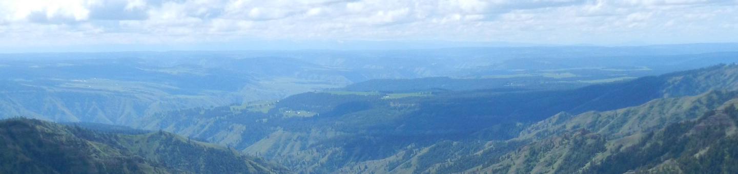
The Umatilla National Forest, located in the Blue Mountains of southeast Washington and northeast Oregon, covers 1.4 million acres of diverse landscapes and plant communities. The forest offers a variety of recreational opportunities from camping, hiking, bicycling, hunting to white water rafting! The forest has some mountainous terrain, but most of the forest consists of v-shaped valleys separated by narrow ridges or plateaus. The landscape also includes heavily timbered slopes, grassland ridges and benches, and bold basalt outcroppings. Elevation range from 1,600 to 8,000 feet above sea level.
For the most up to date recreation information:
Recreation Reports by Ranger District
Recreation Map
A map showing recreation areas.
RecAreaDirections
Open with Google Map
Misc
| Stay Limit | |
| Reservable | false |
| Keywords | |
| Map Link | |
| Contact Phone | |
| Contact Email |
Permits info
Facilities
Umatilla National Forest Christmas Tree Permit Tree Permit
Jubilee Lake Campground (OR) Campground
List of CampsitesOverview
This high elevation, spruce fir surrounded campground is the largest and most popular campground on the Umatilla National Forest. Jubilee Lake is nestled among the trees and the lake provides a beautiful setting for day-use as well as camping. This site is known for good fishing and swimming and is a wonderful way to escape the summer heat.
Jubilee Lake campground offers a variety of recreational actitivies for visitors of all abilities, including fishing and hiking trails.
Recreation
Jubilee Lake campground offers a variety of recreational actitivies for visitors of all abilities, including fishing, crawfishing, a 2.8 mile hiking trail, boating (non-motorized or electric trolling motor only), and wildlife viewing.
Facilities
This campground includes 48 tent/rv sites, 5 tent only sites, 4 vault toilets, 6 flush toilets, a boat ramp, and a day use area. Potabale water is located throughout the campground and trash service is provided. The 2.8 mile Jubilee Lake National Recreation Trail offers a pleasent 2.8 mile stroll around the lake.
Natural Features
The Umatilla National Forest is located in the Blue Mountains of southeast Washington and northeast Oregon and offers a vast selection of majestic scenery and recreational opportunities. It covers 1.4 million acres of diverse landscapes and plant communities. The Forest has some mountainous terrain, but most of the Forest consists of v-shaped valleys separated by narrow ridges or plateaus. The landscape also includes heavily timbered slopes, grassland ridges and benches, and bold basalt outcroppings. Elevations range from 1,600 to 8,000 feet above sea level. Changes in weather are common, but summers are generally warm and dry with cool evenings. Cold, snowy winters and mild temperatures during spring and fall can be expected.
Nearby Attractions
The unincorporated town of Tollgate is located 11.5 miles southwest of the campground. It has a store/resteraunt with gas being available. The 177,423 acre Wenaha-Tucannon Wilderness Area is accessable, via the Timothy Springs Trailhead, 7.8 miles northeast of the campground.
TAMARACK CABIN Campground
List of CampsitesOverview
Tamarack Cabin offers outdoor enthusiasts a quaint cabin with epic views atop Tamarack Mountain. The cabin can accommodate four guests, and a short walk through the trees awards a unique opportunity to view miles of the Umatilla National Forest from sunup to sundown. The site was originally used as a fire detection lookout. The original structure was a platform built on a high tree in 1925. It was replaced with a 96-foot Aermotor tower in 1933, and a neighboring cabin was built to house Forest Service employees. A utility shed was also built. When the cabin burnt down in 1966, the shed was converted into housing. That same shed is where guests can stay today. The tower is also still standing, and when the tower is staffed, visitors are welcome to climb up and enjoy the view.Recreation
Over 26 miles of trails throughout the Heppner Ranger District can be accessed from the cabin for hiking or horseback riding. Plentiful fishing opportunities abound in nearby streams and Bull Prairie Lake. Many roads are open to off-road vehicles, and 28 miles of designated trails are available. Other activities include hunting, wildlife viewing and bird watching. This site is not open in the winter.Facilities
The cozy converted shed offers one room with amenities including propane lights, a heating stove and cook stove, cookware, silverware and dishes. Furnishings consist of two sets of twin bunkbeds, a cabinet for clothes, table with four chairs, and a rocking chair on the small front porch. There is a picnic table and fire ring outside, though fire danger may restrict campfires, so check for conditions with the Ranger District prior to arrival. There is also a nearby outhouse. No water is onsite, so visitors must bring plenty for drinking, cooking and washing. There is no refrigerator either, so come prepared with a cooler and ice. Guests must bring food, water, ice chest with ice, bedding, toiletries, a first aid kit, flashlights, matches and all other basic camping gear. Click here for more cabin details.Natural Features
At 4,979 feet above sea level, Tamarack Mountain overlooks the John Day River basin, between Spray and Kimberly. The lookout and the mountain it tops are named after the western larch, a tree that is particularly plentiful in the Blue and Wallowa Mountains. Western tanagers and dusty flycatchers frequent the area and purple-blue spikes of lupine, white and pink yarrow and yellow balsamroot add bursts of color to the landscape.Nearby Attractions
Heppner is the nearest town with a general store, which is about an hour's drive away. Off-road vehicle enthusiasts enjoy Morrow County OHV Park, located 14 miles southwest. There are some food options and ice for sale at this site.DITCH CREEK GUARD STATION CAB Campground
List of CampsitesOverview
Ditch Creek Guard Station, located about 27 miles southeast of Heppner, Oregon, is a comfortable little cabin that accommodates six overnight guests, plus additional guests camped in a tent outside. Equestrian campers are welcome and a corral with trough is provided. The guard station was originally built by the Civilian Conservation Corps in the mid-1930s. It is a classic example of forest building structures of that era and is eligible for inclusion in the National Register of Historic Places. It was used by forest fireguards who would ride their horse deep into the forest’s interior to look for wisps of smoke from lightning strikes or check on communications lines along the Forest Service roads. It became a recreation rental in 1997.Recreation
The route to the cabin is located off the Blue Mountain Scenic Byway, which boasts incredible views. Over 26 miles of hiking and horseback riding trails, ranging between 4,100 and 5,300 elevation, traverse forests and meadows throughout the Heppner Ranger District. Fishing opportunities abound in nearby streams, Penland Lake and Bull Prairie Lake. Other activities include hunting for deer and elk, mushroom and berry picking, wildlife viewing and enjoying the scenic landscape.Facilities
The cabin is a one-story building containing a bedroom, living room, kitchen with nook and a bathroom. The cabin does not meet accessibility standards due to narrow doorways and halls. A picnic table, campfire ring and a 20' X 20' horse corral with water trough are located outside. Guests may pitch tents in the yard for additional sleeping options. Two bunk beds, a dresser, and a chair are in the bedroom, and the living room has a futon, loveseat, side table, a dining table with four chairs, and a heating stove. A cook stove, fire extinguisher, cookware, silverware and dishes are included in the kitchen. All appliances and lighting are propane, which is provided by the Forest Service. Potable water is available. Guests must bring food, bedding, toiletries, matches, a flashlight, first aid kit and similar camping gear. Cleaning supplies are provided in a closet by the door and guests are expected to clean the cabin before they leave. Click here for more cabin details.Natural Features
The cabin sits near Ditch Creek on a large, flat lawn surrounded by a dense pine forest at an elevation of 4,800 feet. The creek is one of numerous small perennial streams that flow south into the North Fork John Day River. There is a small pond adjacent that is also stocked with fish. Deer and elk are likely to be seen in the area, and as evening falls, guests can watch bats flit and swoop above the yard.Nearby Attractions
The nearest town with a general store is in Heppner, a 40-minute drive away, although ice and some food options are available at the Morrow County OHV park 14 miles away.MINERS RETREAT Campground
List of CampsitesOverview
Miner's Retreat is an old Forest Service cabin that allows guests to relax in the outdoors and also step back in time to when the cabin was used during the bygone gold mining days. Miner's Retreat is part of the Fremont Powerhouse complex, a hub for mining built in the early 1900s. It is one of four cabins located at the site near the town of Granite, and provides great flexibility for larger groups.The surrounding valleys once teemed with mining activity, primarily gold. The Fremont Powerhouse was built in 1908 as an economical method for mining. Two dams were constructed at Olive Lake, and water from the lake was piped through an 8-mile wood and steel pipeline to the powerhouse to generate electricity. Homes were constructed to shelter workers who monitored the pipeline. Today, these same shelters are where visitors can stay overnight.
The cabin is uphill from the Fremont Powerhouse, flanked by Caretakers Cabin and Hilltop Hideaway. Winter access may require skis, snowshoes or snowmobiles.
Click here for a virtual tour of the area.
Recreation
Guests can hike on trails into the North Fork John Day Wilderness or go mountain biking on forest roads. A drive along the Blue Mountain Scenic Byway is a treat, as are other activities like huckleberry and mushroom picking, bird watching, wildlife viewing and photographing the vast landscape. Nearby Olive Lake offers boating, fishing and swimming.Facilities
This cozy little cabin offers a covered front porch and features two bedrooms, a full bath with hot and cold running water (during the summer months only) and a kitchen and living room. The cabin has electric lights throughout and is heated with electric wall heaters.The cabin sleeps up to six and is fully furnished with beds, a couch and a table with chairs. The kitchen is equipped with an electric stove and oven, refrigerator and a variety of utensils, such as skillets, a coffee pot, glasses, cups, dishes and silverware. Cleaning supplies are also provided. Guests must bring sleeping bags or bedding, a flashlight, first aid kit, washcloths, towels and dish soap, among other general camping supplies. Click here for more cabin details.
Natural Features
The cabin sits at an elevation of about 5,000 feet, on a hillside overlooking the expansive Umatilla National Forest near the North Fork John Day Wilderness. A grassy lawn in front leads to the other three cabins in the area. The forest lies in the Blue Mountains and is home to Ponderosa pine and Douglas fir.Birds in the area include the black-backed woodpecker, American kestrel and the Boreal owl. Black bear, elk and deer are among the native land mammals. Click here to learn about bear safety.
Nearby Attractions
The cabin is located less than 6 miles from Granite, Oregon, a ghost town that once bustled with prospectors and pioneers. The town provides groceries and fuel.CONGO GULCH Campground
List of CampsitesOverview
Congo Gulch is an old Forest Service cabin that allows guests to relax in the outdoors and step back in time to when the cabin was used during bygone gold mining days. It is part of the Fremont Powerhouse complex, a hub for mining built in the early 1900s. As one of four cabins located at the site, the cabin offers flexibility for large groups. Guests can rent all cabins and also pitch tents in the grassy yard. The surrounding valleys once teemed with mining activity, primarily gold. The Fremont Powerhouse was built in 1908 as an economical method for mining. Two dams were constructed at Olive Lake, and water from the lake was piped through an 8-mile wood and steel pipeline to the powerhouse to generate electricity. Homes were constructed to shelter workers who monitored the pipeline. Today, these same shelters are available as recreational rentals. Congo Gulch is named for the small creek that runs beside the property. Winter access may require skis, snowshoes or snowmobiles.Recreation
Guests can hike on North Fork John Day Wilderness Area trails or go mountain biking on forest roads. A drive along the Blue Mountain Scenic Byway is a treat, as are activities like huckleberry and mushroom picking, bird watching, wildlife viewing and photographing the vast landscape. Nearby Olive Lake offers boating, fishing and swimming.Facilities
The two-story white cabin with wood siding and a metal roof can accommodate up to 12 guests. It features: · two bedrooms upstairs with dressers, a queen bed, 3 twins, and a full-over-queen bunkbed; · one bedroom downstairs with a dresser and full-over-queen bunkbed; · parlor with dining table/chairs, 2 futons and end tables; · kitchen with refrigerator, electric stove/oven, microwave, coffee pot, toaster, cookware, dishes, and a second dining table with chairs; · full bath with shower/tub and flush toilet. The cabin has electric lights and an oil heating stove. A picnic table and brick fireplace are provided next to the pond (bring your own firewood). Cleaning supplies are also provided and renters are required to clean the house before they leave. Water is available June through September only. No water or indoor plumbing from October to May. Instead, an outhouse is available for use. In these seasons, guests are asked to bring plenty of water for drinking, cooking and washing. Other items to pack year-round include food, bedding, a first aid kit, flashlight, matches and all other basic camping gear. Click here for more cabin details.Natural Features
The cabin sits at about 5,000 feet in elevation and is neatly tucked under a large Douglas-fir, next to a small pond. A grassy lawn in front spreads to the other three cabins in the area. The forest lies in the Blue Mountains and is home to Ponderosa pine lodgepole pine, larch, and Douglas fir. Birds in the area include the black-backed woodpecker, American kestrel and the boreal owl. Black bear, cougar, wolves, elk and deer are among the native land mammals. Click here to learn about bear safety.Nearby Attractions
The cabin is located less than six miles from Granite, Oregon, a ghost town that once bustled with prospectors and pioneers. The town provides groceries and fuel. Opportunities for horseback riding and a boat ramp, boating, fishing, and swimming are located within ten miles from the cabin.WENATCHEE GUARD STATION Campground
List of CampsitesOverview
Wenatchee Guard Station, located about 40 miles southeast of Pomeroy, offers a panoramic view of Wenatchee Creek and access to a scenic drive along Wenatchee Creek Canyon. The year-round cabin attracts cross country skiers and snowmobilers in winter and horseback riders and hikers in summer. Dogs and horses are allowed at the cabin.
The site is accessible by automobile June 1 to November 1, weather dependant. Winter access requires skis, snowshoes or snowmobiles.
As early as the 1910s, the site was used as a Forest Guard Camp. In 1927, a log cabin was built and used until it was replaced with the current guard station, completed in 1935 by the Civil Conservation Corps.
Recreation
Horseback riding and hiking trails can be accessed from the cabin. Another way to enjoy views along Wenatchee Creek is by taking a scenic drive. Berry and mushroom picking is possible, and in winter, trails are groomed for snowmobiling and cross country skiing.Facilities
The wood-framed, single story cabin accommodates up to four people. It features a kitchen, bedroom and living room that also serves as a bedroom. Furnishings include four single beds, chairs and a table.
The cabin is equipped with propane for heat, a cook stove, refrigerator/freezer and propane lighting. Most cleaning supplies, limited dishes, pots, pans and utensils are provided. However, it is strongly suggested visitors bring their own. Water is not available on-site. An outhouse is located nearby. Though horses are allowed, there is no corral and no hitching post; horses must be highlined—trailer access to the cabin is difficult.
Things to bring include food, water, sleeping bags or bedding, a flashlight, matches, first aid kit, trash bags, towels and washcloths. Cabin should be cleaned before your departure, cleaning supplies provided.
Natural Features
Wenatchee Guard Station sits at 5290 ft in a grassy clearing on a high plateau dotted with mixed conifers, offering majestic views of the northern tip of the Blue Mountains. In the spring, wildflowers, such as yarrow, Piper's anemone, Big-leaf sandwort, Showy Aster, Camas pink fairy, daisy and sagebrush sweep color down the slopes into the valleys.
Campers enjoy the view of Grouse Flats and look for herds of Rocky Mountain elk, mule deer and white-tailed deer. They can also listen for the call of geese, ducks, hawks, grouse, wild turkeys, screech owls and wrens.
Nearby Attractions
The cabin is about 35 minutes from any general store. The town of Pomeroy has a county museum, art gallery and antiques.Charges & Cancellations
For Reservation Changes & Cancellation Fees, please see Rules & Reservation Policies.
GODMAN GUARD STATION Campground
List of CampsitesOverview
Godman Guard Station, built in the 1930s, sits just outside the impressive Wenaha-Tucannon Wilderness. The complex is adjacent to a historic Civilian Conservation Corps campground. Horseback riding and hiking trails into the wilderness are easily accessed from the cabin. Horses are permitted in the area, however, due to sanitary reasons, horses are not allowed near the guard station. Horses may be tied to the barn’s hitching rails located about 200 yards up the hill. The barn cannot be used by renters, just the hitching rails and feed bunks. Winter access is by snowmobile, snowshoes or cross country skis. A groomed snowmobile trail passes right by the cabin.Recreation
Guests will delight in viewing scenery along Skyline Drive Road and the Wenaha-Tucannon Wilderness. During the summer months, horseback riding or hiking in the wilderness are popular pastimes. Many trails descend into the rugged river canyons and offer fishing opportunities. Check with the appropriate state Department of Fish and Wildlife for regulations. The Godman Trailhead can be accessed from the cabin. In winter, campers enjoy snowmobiling on groomed trails, snowshoeing and cross-country skiing.Facilities
The two-story, wood frame structure sleeps up to eight people and features two bedrooms, a living area, and kitchen. An outhouse is available year-round. Furnishings include two bunkbeds, four single beds, four recliner style chairs, a kitchen table and chairs. Also provided are a propane stove, heat, lights and refrigerator. Outside the cabin there is a firepit and picnic table.
Guests should bring water year-round. A spring is nearby for those who wish to treat and boil water for drinking.
Guests will also need to bring food, bedding, dishes, cooking utensils, pots and pans, trash bags and a first aid kit.
Cabin should be cleaned before departure. Mop, bucket, broom & cleaning supplies are provided.
Natural Features
Godman Guard Station is perched above the Wenaha-Tucannon Wilderness at an elevation of 5,600 feet. From a barn about 100 yards up the hill from the cabin, expansive views of the wilderness can be seen. The wilderness includes nearly 180,000 acres of rugged basaltic ridges, steep canyons, rushing rivers and their tributaries and abundant wildlife. Rocky Mountain Elk, bighorn sheep, white-tailed and mule deer, black bears, cougars, coyotes and pine martens inhabit the region.Nearby Attractions
The cabin is 28 miles or a one-hour drive from Dayton. Groceries and fuel are available. The Tucannon Last Resort Store is also about an hour's drive away.Charges & Cancellations
For Reservation Changes & Cancellation Fees, please see Rules & Reservation Policies.
CLEARWATER LOOKOUT CABIN Campground
List of CampsitesOverview
Clearwater Lookout Cabin is a single story, wood frame structure constructed in 1935. It is tucked at the base of the Clearwater Lookout tower, a 94-foot steel tower constructed by the Civil Conservation Corps in 1933. Through the years, the tower has been used as a landmark by the public and employees of the Forest Service. The tower is no longer manned during fire season, but it is used on occasion during extreme fire conditions. The tower is closed to public access, but the rental cabin is open year-round. The cabin is located about 25 miles south of Pomeroy, Washington in the Umatilla National Forest. Access by car is from June 1 to October 31 weather permitting. In winter, access is limited to cross country skis, snowshoes or snowmobile.Recreation
Horseback riding and hiking trails can be accessed from the cabin. During spring and summer, guests can enjoy a short and scenic drive along the Tucannon River to Sunset Point. Mushroom and berry picking may also entertain guests. At night, guests enjoy gazing up at the star-filled sky.Winter brings avid snowmobilers and skiers to explore its groomed trails.
Facilities
The cabin is divided into a kitchen and a bedroom, and is furnished with four extra-long single beds. It is kept warm in the winter by a propane heater, and features propane lights, a cook stove and a refrigerator, as well as some cookware, dishes and utensils. However it is suggested that visitors bring their own dishes, pots, pans and utensils. There is a firepit and picnic table outside. An outhouse is located nearby.
There is no water on-site, so visitors must bring plenty for drinking, cooking and washing. Other things to bring include bedding or sleeping bags, flashlights, dish soap and other basic camping gear. Cabin should be cleaned before departure. Mop, bucket and cleaning supplies provided.
Natural Features
Perched at 5,600 feet elevation, Clearwater Lookout Cabin offers panoramic views of the expansive Wenaha-Tucannon Wilderness, from sunrise to sunset.The rugged landscape of the wilderness stretches across the northern Blue Mountains of southeastern Washington and northeastern Oregon. The mountain slopes are carpeted with bunchgrass, lodgepole pine and subalpine fir.
An array of wildlife, including Rocky Mountain Elk, bighorn sheep, white-tailed and mule deer, black bears, cougars and coyotes may be spotted.
Nearby Attractions
The nearest general stores and gas stations are in Pomeroy, a 40-minute drive from the cabin.Charges & Cancellations
For Reservation Changes & Cancellation Fees, please see Rules & Reservation Policies.
CLEARWATER BIG HOUSE Campground
List of CampsitesOverview
Clearwater Big House gives the feel of a winter chalet hideaway, even during the warmest months of the summer. Hiking, horseback riding and scenic drives abound, delighting guests year after year. The Clearwater Lookout Tower is a mile away. The tower is not open, but the area is nice for scenic views.An old trapper cabin was located at the current site and was later used as a ranger station. From 1928-29, a ranger built a three-room house and by 1933, the Civilian Conservation Corps was tasked with building a barn, warehouse, outhouse and garage.
In winter, the cabin is well-suited for snowmobiling and cross country skiing on groomed snowmobile trails. These modes of over-snow transportation are required for winter access to the cabin.
Recreation
The cabin provides nearby access to hiking and horseback riding trails that lead to Teal Springs and the lush Tucannon River Drainage. The scenic drive along the Tucannon River Drainage to Sunset Point is also a recommended activity.
In winter, snowmobiling, cross country skiing and snowshoeing trails are right out your front door.
Facilities
The cabin has 868 square feet of living space on the first floor, and another 336 square feet upstairs, and can accommodate up to 10 people. It is fully furnished with 3 queen, 1 full, and 5 twin beds, and a dining table and chairs. Propane heat and lighting are included, and the kitchen is equipped with a propane cook stove and refrigerator. The cabin does not have indoor bathroom facilities. There is an outdoor fire ring and a picnic table. An outhouse is located across the road. Cabin should be cleaned before your departure. Mop, bucket and cleaning supplies provided.
No water is provided. Guests need to bring plenty of water for drinking, cooking, and washing. They should also bring cooking pots and utensils, bedding or sleeping bags, dish soap, matches, a flashlight and all other basic camping items.
Natural Features
Set on a gently rolling slope at an elevation of 5,600 feet, the cabin is nestled in a clearing dotted with young Christmas trees. The Wenaha-Tucannon Wilderness is nearby, stretching across the northern Blue Mountains of southeastern Washington and northeastern Oregon.The mountain slopes are carpeted with bunchgrass, lodgepole pine and subalpine fir. An array of wildlife, including Rocky Mountain Elk, bighorn sheep, white-tailed and mule deer, black bears, cougars and coyotes, may be spotted.
Nearby Attractions
The nearest general stores and gas stations are in Pomeroy, a 40-minute drive from the cabin.Charges & Cancellations
For Changes & Cancellation Fees, please see Rules & Reservation Policies.
CARETAKERS CABIN Campground
List of CampsitesOverview
Caretaker's Cabin allows guests to relax in the outdoors at the historic Fremont Powerhouse site. As one of four cabins located at the site, the cabin offers flexibility for large groups, like weddings or reunions. Guests can rent all cabins (see Congo Gulch, Hilltop Hideaway, and Miner's Retreat) and also pitch tents in the grassy yard. Caretaker’s Cabin sits on a hill beside Miner’s Retreat and has parking access beside it. The cabin can accommodate up to 10 guests. Winter access may require skis, snowshoes or snowmobiles. In the 1800s, the North Fork John Day drainage was bustling with gold and silver mining. Around 1903, local mines began to notice a decline in earnings and promoted construction of a cheaper power source in an effort to operate the mines more economically. As a result, the Fremont Powerhouse was constructed and began operation in 1908. Two dams were constructed at Olive Lake and water from the lake was piped through an eight-mile-long wood and steel pipeline to the powerhouse to generate the much-needed electrical power. The Caretaker’s Cabin house was constructed in the 1930s to shelter workers who monitored the pipeline for leaks and kept the powerhouse operating. The entire site and pipeline are listed as an historic district on the National Register of Historic Places.Recreation
Guests can hike on North Fork John Day Wilderness trails or go mountain biking on forest roads. A drive along the Blue Mountain Scenic Byway is a treat, as are activities like huckleberry and mushroom picking, bird watching, wildlife viewing and photographing the vast landscape. Nearby Olive Lake offers boating, fishing and swimming.Facilities
The cabin is a 2-story house with wood siding and a shake shingle roof that can accommodate 10 guests. The cabin features: · two bedrooms upstairs with dressers, 2 twin beds, and 2 full-over-queen bunkbeds; · parlor with 2 futons and end tables; · dining room with a table and chairs to seat 10; · kitchen with refrigerator, electric stove/oven, microwave, coffee pot, toaster, cookware, and dishes; · bathroom with flush toilet and claw-footed tub (no shower). Outside there is a fire ring and picnic table--prior to arrival please contact the District office to determine whether fires have been banned. The cabin has electric lights and electric wall heaters. Cleaning supplies are also provided and renters are required to clean the house before they leave. Water is available June through September only. No water or indoor plumbing from October to May. Instead, an outhouse is available for use. In these seasons, guests are asked to bring plenty of water for drinking, cooking and washing. Other items to pack year-round include food, bedding, a first aid kit, flashlight, matches and all other basic camping gear. Click here for more cabin details.Natural Features
Perched on a small rise at about 5,000 feet in elevation, the cabin is set on a hillside under a large spruce tree. A grassy lawn in front spreads to the three other cabins in the area. The forest lies in the Blue Mountains and is home to Ponderosa pine, lodgepole pine, larch and Douglas-fir. Birds in the area include the black-backed woodpecker, American kestrel and the boreal owl. Black bear, cougar, wolves, elk and deer are among the native land mammals. Click here to learn about bear safety.Nearby Attractions
The cabin is located less than 6 miles from Granite, Oregon, a ghost town that once bustled with prospectors and pioneers. The town provides groceries and fuel. Opportunities for horseback riding are within 10 miles of the cabin.SUMMIT GUARD STATION BUNKHOUSE Campground
List of CampsitesOverview
Summit Guard Station Bunkhouse sets the stage for a truly relaxing getaway. Located on the breaks of Meacham Canyon in Umatilla National Forest, spectacular views of the Blue Mountains are guaranteed. The rustic bunkhouse, built by the Civilian Conservation Corps, dates back to 1938.The site of the cabin was the Summit Ranger Station in 1908, when the land was part of the Wenaha National Forest. Wenaha was one of the first national forests in the country, established in 1907. It was renamed Umatilla National Forest in 1920.
Recreation
Bird and wildlife watching is exceptional at Summit.Facilities
The single-room cabin accommodates up to four guests. The red, wood framed cabin has two full beds and two twin beds with mattresses, a table and four chairs, and is equipped with a propane cook stove, propane lights and a propane heater. The cabin is stocked with a limited supply of pots, pans, eating utensils and cleaning supplies. A vault toilet is located a short distance from the cabin and additional guests may use the yard to pitch a tent. No water is available on-site, so guests must bring plenty of water for drinking, cooking and washing. Other items to bring include food, bedding, towels, garbage bags, dish soap and a first aid kit. It's a great idea to bring binoculars as well. Click here for more cabin details.Natural Features
Summit Guard Station is located on a high ridge nestled in an open stand of large Ponderosa pine and Douglas fir. The view to the south and west from this ridge-top setting is exceptional. Prominent points in the area include Wilbur Mountain, Spring Mountain, Sugarloaf Mountain and Green Mountain.Bird species in the region include kinglets, sparrows, chickadees and hummingbirds, while wildflowers include larkspur, lupine and orchids.
Nearby Attractions
The Whitman Route Overlook is a short drive away, boasting views of Meacham Canyon and the Hell Hole Roadless Area, as well as a look back into the history of the area.FRY MEADOWS GUARD STATION Campground
List of CampsitesOverview
Fry Meadows Guard Station offers the peaceful solitude of a remote nature-lover's paradise just south of the Wenaha-Tucannon Wilderness and west of the Grande Ronde Wild and Scenic River. The surrounding area is steeped with native history and culture as it was once home to the Nez Perce, Umatilla, Walla Walla and Cayuse Indians. This site was originally established as a ranger station before 1908, part of the former Wenaha National Forest. The existing cabin was constructed in 1935 by the Civilian Conservation Corps and was used as a remote guard station until about 1980. The two-room cabin provides a pleasant escape for up to six guests. Additional guests may pitch a tent in the yard. Pets are welcome but must be leashed and outsideRecreation
The Wenaha-Tucannon Wilderness offers more than 200 miles of managed trails for hiking and horseback riding in summer. The Grande Ronde Wild and Scenic River offers float boating, salmon and steelhead fishing. Hunting is available nearby.Seasonal mushroom and berry picking can also be enjoyed. Huckleberries, blackberries and morel mushrooms are among the edible picks.
Facilities
The cabin is a classic 1930s Civilian Conservation Corps two-room design. It is equipped with a propane cook stove, propane heater and propane lights. Furnishings include two full beds and two twin beds with mattresses, tables and chairs, limited cleaning supplies, cooking pots and utensils. A vault toilet is located a short distance from the cabin. The cabin has no water. Visitors must bring plenty for drinking, cooking and washing. Please bring sleeping bags or bedding, a flashlight, first aid kit, washcloths, towels and dish soap. Click here for more cabin details.Natural Features
Tucked beneath the shady canopy of towering spruce and fir, the guard station sits at the edge of an expansive meadow of grasses and wildflowers, such as lupine, larkspur, monkey flower and orchid.As the afternoon slides into evening, deer and elk come out to graze. Hawks perch in treetops or glide over the meadow, scanning the grass for field mice and other critters. In the morning, many varieties of birds, including flycatchers, hummingbirds, swallows, chickadees, creepers, wrens, kinglets, thrushes, sparrows, warblers, tanagers and finches, greet the day.
Nearby Attractions
This site is located about 25 miles northeast of Elgin, Oregon, which offers general stores and gas stations.TUCANNON GUARD STATION Campground
List of CampsitesOverview
The historic Tucannon Guard Station is a charming saltbox-style cabin constructed in 1909. It was inhabited by the first ranger in the Tucannon area, William Kendell, and his family. By 1916, the guard house became headquarters for the district for two years, and then continued on as a standard guard station.Staying here is like stepping back in time. The rooms inside are nicely decorated and cozy. Touches like curtains on the windows and modern furniture add to the destination experience. Beyond the cabin is plenty of photogenic scenery, plus options for prime fishing and hiking.
Recreation
Just a few miles south are trailheads to wilderness hiking trails. Plus the road along the Tucannon River is a notable scenic drive, ideal for viewing flora and fauna.Facilities
Tucannon is a two-story wood frame structure with wood siding and a shake shingle roof. The upstairs is divided into two sleeping areas, one furnished with a bunkbed and a single bed and the other with a double bed. The ground floor has a spare ‘museum’ room with historic pictures and a living room furnished with a futon that sleeps two. The downstairs bathroom is equipped with a flush toilet and shower/tub with hot water.
Electricity and propane are included for heating and cooking. The kitchen and dining area boast a cook stove and refrigerator, plus a table and chairs. The cabin has potable running water year round. A picnic table beneath the trees & firepit sit outside.
Most cleaning supplies, dishes, pots, pans and utensils are provided, but visitors are encouraged to bring their own. Guests should also bring bedding or sleeping bags, and basic camping gear like flashlights, dish soap and matches. Cabin should be cleaned before departure. Mop, bucket, broom and cleaning supplies provided.
Natural Features
The cabin is at 2600 ft elevation on a shady, gently rolling site at the base of a hillside in Tucannon Valley. The rugged landscape stretches across the northern Blue Mountains of southeastern Washington and northeastern Oregon.
Visitors may spot local inhabitants like wild turkey, pheasant, deer, elk and even an occasional moose in the area.
Nearby Attractions
A convenience store, gas station and RV park is located about 9 miles, or 15 minutes, north of the cabin. River access and opportunities for hunting and mushroom picking are also within 10 miles of the cabin.Charges & Cancellations
For Changes & Cancellation Fees, please see Rules & Reservation Policies.
Heppner Ranger District Facility
The Heppner Ranger District is located in Heppner, Oregon. The District embraces 212,213 acres of the beautiful Blue Mountains, which includes portions of Grant, Morrow, Umatilla, and Wheeler Counties. There are approximately 500 miles of open roads to travel on, 27 miles of trails to hike, and 248 miles of streams that flow into 3 major rivers within Eastern Oregon.
Blue Mountain Byway West Interpretive Site Facility
Blue Mountain Byway West Interpretive Site
Bull Prairie Campground (OR) Campground
List of CampsitesOverview
Bull Prairie Campground is a local gem and is considered a beautiful, woodsy place to enjoy a vacation, host family reunions or social events, and to enjoy multiple recreational pursuits. This moderate-sized campground is located adjacent to 28- acre Bull Prairie Lake, which is(stocked annually with trout. There is afamily-friendly and accessible paved trail along the lake designed for people who enjoy morning jogs, bicycle rides, picnicking, and fishing (with several docks along the trail). The lake has a boat ramp, dock and trailer parking area, but only non-motorized boating is allowed. Nearby trails connect the campground and lake with the Morrow County OHV Park. Note: ATVs are only allowed at the dump station and in the north part of the campground (sites 25-28).
While this campground offers potable water, there is no garbage service so please pack out all garbage and dispose of it at home.
Recreation
There is a family-friendly, accessible paved trail around the lake that is designed for people who enjoy morning jogs, bicycle rides, picnicking, and shoreline/dock fishing. Non-motorized boating is allowed with a boat ramp, dock and parking area for trailers. Within the campground adjacent to the lake, is a large, day use picnic area with accessable facilities. Besides beautiful scenery, the lake offers many opportunities for wildlife viewing and photography. Hunting activities are available nearby, but not within this recreation site.
Facilities
This campground features 28 tent/rv campsites,1 tent only campsite, 1 group campsite, and 8 accessible vault toilets. Potable water is avialable seasonally throughout the campground and picnic area; no rv hook ups are available. There is a 1.2 mile paved trail that loops around the lake, together with 4 accessible fishing docks.
Natural Features
This campground is fully forested with Ponderosa pine, Douglas-fir, grand fir, and spruce. Trout are stocked in the nearby lake. Deer, chipmunks, squirrels, and rabbits frequent the campground and waterfowl inhabit the lake and shore. It is also possible to sight an occasional elk in the nearby area. Bears and cougars live in the surrounding forest, but rarely enter the campground and bear-proof storage is not required. Mushroom and berry picking occur seasonally.
Nearby Attractions
The Morrow County OHV Park is located 8 miles north of the campground. Heppner, OR, located 41.5 miles to the north, is the closest location for supplies and gasoline.
Charges & Cancellations
Cancelling a Reservation: Customers may cancel their reservation prior to arrival both on-line and through the call center. A $10 service fee will be withheld from any refund for a cancellation. Depending on when you cancel in relation to your arrival day, it may be considered a late cancellation (see below).
Individual Campsites: A customer who cancels a reservation the day before or on the day of arrival will pay a $10.00 service fee AND forfeit the first night's use fee (not to exceed the total paid for the original reservation). Cancellations for a one-night reservation will forfeit the entire amount paid and will not be subject to an additional service fee.
Group Facility (including Cabins and Lookouts): Customers who cancel a group overnight facility reservation less than 14 days before the arrival date will pay a $10.00 service fee AND forfeit the first night's use fee.
Columbia Interpretive Site Facility
Columbia Interpretive Site
Ione Interpretive Site Facility
Ione Interpretive Site
Kelly Prairie Facility
The prairie is located along the Blue Mountain Scenic Byway and offers spectacular displays of wildflowers in the spring. This site is minimally developed, with only a parking area. There are no informational signs or other facilities.
Lexington Interpretive Site Facility
Lexington Interpretive Site
North Fork John Day Ranger District Facility
 The North Fork John Day District is 465,000 acres in the heart of the Blue Mountains. Diversity and complexity are key words in management of this land and its abundant resources. Plant communities range from juniper/sage/bunch grass at the 2,600 feet elevation in the Potamus Creek area to subalpine fir/whitebark pine habitats at the 8,000 feet elevation near Vinegar Hill in the Greenhorn Mountain Scenic Area
North Fork John Day Overlook Interpretive Site Facility
The North Fork John Day Overlook Interpretive Site is located just off Forest 52 and offers a spectacular view of the North Fork John Day Wilderness, river basin and Bridge Creek Wildlife area. Fire scars from the Tower Fire that burned over 50,000 acrea in 1996 are visable along the route and from the overlook.
Aspen Grove Interpretive Site Facility
The Aspen Grove Interpretive Site offers visitors a look at Aspen conservation and resoration management practices. The grove is fenced with an interpretive sign.
Basin Trailhead Facility
Provides access to: Basin Creek Trail #3006 which enters North Fork John Day Wilderness and ends after 1.3 miles at it's junction with Glade Creek Trail #3014.
Directions: From Dale, OR, travel northwest on US-395 N for 1.2 miles. Then turn right (east) on Forest Road 55. After about 1 mile, take the first right onto Forest Road 10. Continue for about 8.7 miles, then turn left onto Forest Road 1010 for another 7 miles to the trailhead. There is a large parking area and message board.
Battle Creek Trailhead Facility
Battle Creek Trailhead provides access to Battle Creek Trail #3004. A large parking lot will support up to six truck/trailer combinations. Just east of the parking lot is Forest Road 1010130. To reach the trail, travel down Forest Road 1010130 for a little over one mile. At that point the road turns into the trail and shortly thereafter forks with Welch Creek Trail heading west (right) and the Battle Creek Trail heading due south to the left.
Blue Mountain Byway East Interpretive Site Facility
The Blue Mountain Byway East Interpretive Site is located on Forest Road 73 at the east end portal to the Blue Mountain Scenic Byway and it's junction with the Elkhorn Scenic Byway. The interpretive site is just south of the North Fork John Day Campground. A picnic table is set below the kiosk in the trees for day use.
Glade Creek/Cold Springs Trailhead Facility
Provides access to: Cold Spring Trail #3008 and Glade Creek Trail #3014 which enter North Fork John Day Wilderness.
The trailhead is at the end of a short, steep loop spur. There is a dispersed camp site with parking for 2 trucks with trailers.
Directions:
From Dale, OR, go north on US-395 about 1.2 miles and turn right (east) onto Forest Road 55. After less than 1 mile, turn right onto Forest Road 10 and travel about 10 miles east to Forest Road 1010. Turn left on Forest Road 1010 and go about 10 miles to the Glade Creek/Cold Springs Trailhead on the north side of the road.
From Granite, OR travel west on Grant County Road 24 (Forest Road 10) for 3.4 miles until the pavement turns to gravel. Continue on Forest Road 10, which turns uphill to the right (west). Travel another 11.5 miles on Forest Road 10 (past the entrance to Olive Lake) then turn right (north) onto Forest Road 1010. Travel about 6 miles west on Road 1010 and the trailhead is up a steep spur road on the right. The spur road is about 1.5 miles west of the turn-off for Desolation Lookout.
Crane Creek Trailhead Facility
Provides access to: Crane Creek Trail #3011 and North Crane Trail #3171 which access North Fork John Day Wilderness.
Directions: From Granite, OR take Forest Road 73 north for about 6.5 miles to the trailhead on the west side of the road.
There is a large, fenced parking area with 1 dispersed campsite and interpretive signs. This site is directly adjacent to the Elkhorn National Scenic Byway.
Forks Trailhead Facility
Provides access to: Forks Trail #3019 which travels south for nearly 7 miles within North Fork John Day Wilderness.
Limited parking is available. Dispersed campsites with corrals are located close to the trailhead.
Directions:From Granite, OR head north on Forest Road 73 for 8.6 miles. Then continue northwest on Forest Road 52 for about 17 miles. Then turn left (south) on Forest Road 5225 and travel about 3 miles to the trailhead just behind the Forks Guard Station.
From Ukiah, OR, travel about 23 miles to Forest Road 5226/5225 junction. Turn right (south) onto Forest Road 5225 and travel about 3 miles to the Forks Guard Station. The trail takes off just behind the Station. There are a horse corral and large dispersed campsites adjacent to the trailhead.
Forks corral and dispersed camp:

Four Corners Sno-Park Facility
This site features a large paved parking lot for the convenience of snowmobile users and cross country skiers. This open area has no marked or groomed trails.
Hilltop Hideaway - Umatilla NF (OR) Campground
List of CampsitesOverview
Hilltop Hideaway is a 1930's era cabin that allows guests to relax in the outdoors and step back in time to the bygone gold mining days. Hilltop Hideaway is part of the Fremont Powerhouse complex, a hub for mining built in the early 1900s. It is one of four cabins located at the site near the town of Granite, and provides great flexibility for larger groups. The surrounding valleys once teemed with mining activity, primarily gold. The Fremont Powerhouse was built as an economical power source for mining. Two dams were constructed at Olive Lake and the water was piped through an 8-mile wood and steel pipeline to the powerhouse to generate electricity. Homes were constructed to shelter workers who monitored the pipeline. Today, these same homes are available for the public to enjoy. Hilltop Hideaway is the cabin farthest uphill from the Fremont Powerhouse. Winter access may require skis, snowshoes or snowmobiles. Click here for a virtual tour of the area.
Recreation
Guests can hike on trails into the North Fork John Day Wilderness or go mountain biking on forest roads. A drive along the Blue Mountain Scenic Byway is a treat, as are other activities like huckleberry and mushroom picking, bird watching, wildlife viewing and photographing the vast landscape. Nearby Olive Lake offers boating, fishing and swimming.
Facilities
This cozy little cabin features one bedroom with a queen over queen bunkbed, a full bath with hot and cold running water (during the summer months only), a kitchen, and a living room. The cabin has electric lights throughout and is heated with electric heaters. The cabin sleeps up to four and is fully furnished with beds, a couch, and a table with chairs. The kitchen is equipped with an electric stove and oven, refrigerator, microwave and a variety of utensils, such as pots/skillets, a coffee pot, toaster, dishes and silverware. Cleaning supplies are also provided. Guests must bring sleeping bags or bedding, a flashlight, first aid kit, washcloths, towels and dish soap, among other general camping supplies. Click here for more cabin details.
Natural Features
The cabin sits at an elevation of about 5,000 feet, on a hillside overlooking the expansive Umatilla National Forest near the North Fork John Day Wilderness. A grassy lawn in front leads to the other three cabins in the area. The forest lies in the Blue Mountains and is home to Ponderosa pine and Douglas fir. Birds in the area include the black-backed woodpecker, American kestrel and the Boreal owl. Black bear, cougar, wolves, elk and deer are among the native land mammals. Click here to learn about bear safety.
Nearby Attractions
The cabin is located less than 6 miles from Granite, Oregon, a ghost town that once bustled with prospectors and pioneers. The town provides groceries and fuel.
Granite Creek Trailhead Facility
Provides access to: Granite Creek Trail #3016 which enters North Fork John Day Wilderness.
The trailhead is well signed with two large parking areas and an information board.
Howard Creek Trailhead Facility
Trailhead accessing Howard Creek Trail #3005
Lost Creek Trailhead Facility
Provides access to: Lost Creek Trail #3002 which enters North Fork John Day Wilderness.
Directions: From Granite, travel west on Grant County Road 24 (Forest Road 10) for 3.4 miles until the pavement turns to gravel. Continue on Forest Road 10, which turns uphill to the right (west). Travel another 7.5 miles on Forest Road 10 and the trailhead is located on the right (north) side of the road. The trailhead has parking for 3-4 trucks with trailers and an information board. The Lost Creek Trail # 3002 begins on the other side of Road 10. Olive Lake is less than one mile to the west.
Olive Lake Campground (OR) Campground
List of CampsitesOverview
Nestled on the edge of a lake, high in the Blue Mountains of Eastern Oregon, this popular campground is only 8 miles west of the historic Fremont Powerhouse and 12 miles west of the old mining town of Granite. The campground features 28 campsites and 7 accessible toilet facilities. Other features include a 2-mile hiking trail around the lake with nearby access to wilderness and scenic area trails, a boat ramp and 2 docks. There is no potable water or garbage service, so please pack your garbage home.
Besides beautiful scenery, the lake offers many opportunities for wildlife viewing--particularly a nesting pair of osprey that return annually. Activities in this area include fishing, boating, swimming, hiking, hunting, and photography. Within 20 miles are several historic sites.
Recreation
A 2-mile hiking trail encircles the lake, providing access to more secluded spots where solitude can be enjoyed. Bicyclists can also enjoy the trail although there are a couple of spots bikes might need to be walked, depending on skill level. Anglers can fish for rainbow trout, cutthroat trout, brook trout, and kokanee and crawfish boils are a popular dinner option. There are 2 boat docks adjacent to the campground, as well as a boat ramp and trailer parking. Motorized boats are allowed on the lake, but wakes and jet skis are not allowed. There are opportunities for viewing wildlife such as deer, elk, bear, river otters, and osprey. Mushroom and berry picking are available in season. Other nearby trails access the North John Day Wilderness Area and Vinegar Hill Scenic Area. An interpretive sign about the beetle infestation is located in a few spots within the campground.
Facilities
The campground features 20 tent/RV campsites, 2 group sites, 6 tent only sites and 7 accessible toilet facilities. Other features include a 2-mile hiking trail around the lake with nearby access to wilderness and scenic area trails, a boat ramp and 2 docks, and an interpretive sign. There is no potable water or garbage service, so please pack your garbage home. Potable water can be obtained from Fremont Powerhouse, 7 miles east of the campground from May 15-Sept 30.
Nearby Attractions
The area around Olive Lake is rich in history. The dam and gates on the north side of the lake were constructed as part of a hydroelectric system to support gold mining activities within the northern Blue Mountain Region. Historically, water from the lake flowed through a wooden pipeline to the Fremont Powerhouse, where it was used to produce electricity for mines and towns in the area. Fremont Powerhouse is located approximately 7 miles east and the historic moning town of Granite is 12 miles east of Olive Lake along Forest Road 73.
Packsaddle Trailhead Facility
Provides access to: Packsaddle Trail #3029 (south) and nearby Christensen Trail #3185 (north). Both are OHV trails, although the Packsaddle Trail turns ceases being open to OHVs at the wilderness boundary (about 1.5 miles from the trailhead). There are several large dispersed campsites adjacent to this trailhead. This site is directly adjacent to Blue Mountain National Scenic Byway.
Packsaddle Trail #3029 enters North Fork John Day Wilderness where Wilderness restrictions apply.
Secondary parking and dispersed campsite:

Directions:
From Ukiah, OR follow Forest Road 52 east for about 29 miles to the trailhead on the south side of the road.
Potamus Point Interpretive Site Facility
Potamus Point Interpretive Site
South Fork Desolation Trailhead Facility
trailhead
Skinner Diggins Trailhead Facility
trailhead
Pomeroy Ranger District Facility
The Pomeroy Ranger District, the northern-most District of the Umatilla National Forest, is located within the Blue Mountains of southeastern Washington and northeastern Oregon. These mountains are made up of high plateaus, deeply cut by an intricate system of steep-walled, rim-rock canyons, offering excellent views of the canyons and area surrounding them.
Diamond Trailhead Facility
Provides access to: Mt Misery Trail #3113, Melton Creek Trail #3124 that both access Wenaha-Tucannon Wilderness. Jelly Springs Trail #3110 is also accesssed from this trailhead from Mt. Misery Trail west of the trailhead. Jelly Springs heads north to meet Forest Road 40.
Diamond Trailhead does not have any facilities for user groups. Parking is limited at the trailhead. This is one of the first hit areas on the District by winter snow falls, thus it is hazardous to get out of the trailhead when there is a snow cover.
Practice Leave-No-Trace camping ethics. Pack all garbage out.
Saddle Spring Trailhead Facility
Saddle Spring Trailhead
Timothy Springs Trailhead Facility
Provides access to: Wenaha River Trail #3106 which is popular hiking trail access to Wenaha-Tucannon Wilderness from the Oregon side.
Directions: From Troy, OR take Troy Road south for a .5 mile and then continue on Eden Lane for 2.2 miles. Turn right on Jubilee Road and follow for 2 miles. Continue onto Forest Road 62 for about 21.5 miles. Take a slight right onto Forest Road 6413 before reaching Lookout Mountain and travel 1.2 miles. Take the first right onto Forest Road 6415/Timothy Spring Road and follow about 6.6 miles to the trailhead.
Troy Trailhead Facility
Provides access to: Wenaha River Trail #3106 which follows the Wenaha River west into Wenaha - Tucannon Wilderness. This is also a popular access point to meet up with Crooked Creek Trail #3100 or Smooth Ridge Trail #3105 that are accessed via Wenaha River Trail #3106.
This traihead is located in Troy, OR. The trailhead is located at a wide spot in Barlett Road. Interpretive signs are available.
Directions: From Pomeroy, WA take Highway 12 east for 29 miles. Then go right (south) onto State Highway 129. Follow Highway 129 for 38 miles. Then turn right on Grande Ronde Road and follow it for 17.4 miles (enters into Oregon). Turn right on Barlett Road and follow for about 0.5 miles to the trailhead.
Blue Mountain Scenic Byway Facility
 The Blue Mountain Scenic Byway, designated in 1989 under the National Scenic Byway Program, allows east-west travelers an alternative route between the Columbia River near Arlington and Baker City, Oregon. This scenic byway covers 130 miles of paved, two-lane road, crossing Morrow and Umatilla counties in northeast Oregon, with a long segment of the byway traversing the Umatilla National Forest.
See also: Blue Mountain Scenic Byway Points of Interest
North Fork John Day Campground (OR) Campground
List of CampsitesOverview
This campground sits along the Wild and Scenic North Fork John Day River at the junction of the Blue Mountain and Elkhorn Scenic Byways. It features 20 campsites, 3 accessible toilet facilities, and stock handling facilities. There is no potable water or garbage service, so please pack your garbage home.
This campground serves as the eastern access point to the North Fork John Day Wilderness via North Fork John Day River Trail #3022. The area offers hunting, fishing, hiking, horseback riding, berry and mushroom picking, sight-seeing, and photography opportunities. In spring and fall you can see the salmon spawning. Special state fishing regulations apply.
If you like to drive, you can pick up the Ukiah-Granite Roadside Geology auto tour brochure from the camp host or the Ranger District.
Recreation
This campground serves as the eastern portal into the North Fork John Day Wilderness and offers hunting, fishing, hiking, horseback riding, sight-seeing, and photography. Berries and mushrooms can be found in season. If you like to drive, you can pick up the Ukiah-Granite Roadside Geology auto tour brochure from the camp host or the Ranger District office. if you are interested in history, there are numerous remnants of mining left from the turn of the century, Remember, historic objects, even if they look like trash, are protected by law and may not be removed.
Facilities
This campground features 14 tent/rv campsites, 5 tent only campsites, 1 group campsite, 3 accessible vault toilets, and stock handling/holding facilities (stock is only permitted in the north half of the campground from sites 10-16). There is no potable water or garbage service, so please pack your garbage home.
Natural Features
The campground is set amidst a lodgepole pine forest, with over half of the sites in the shade. The perennial North Fork John Day River runs adjacent to the campground where you can see spawning steelhead and chinook salmon in spring and fall. In the surrounding forests live coyotes, deer, elk, wolves, bear, and cougar, plus a myriad of small animal species.
Nearby Attractions
The historic mining town of Granite is 9 miles south. State of Oregon Parks has a restored dredge that can be toured in the town of Sumpter, 22 miles south. Olive Lake is 21 miles south and west of the campground, and offers fishing , crawfishing, swimming, motorized boating (no wake allowed) and nearby trails for hiking/horseback riding (horses are not allowed in the campground). The lake-turned-reservior was constructed as part of a hydroelectric system to support gold mining activities in the northern Blue Mountain Region in the early 1900's. Historically, water from the lake flowed through a wooden pipeline for 9 miles to the Fremont Powerhouse, where it was used to produce electricity for mines and towns. The Powerhouse is approximately 14 miles south and west of the NFJD Campground on the same road that accesses Olive Lake.
North Fork Umatilla Wilderness Facility
The North Fork Umatilla Wilderness, located 30 miles east of Pendleton, is the smallest wilderness in northeast Oregon. It encompasses only 20,299 acres in Umatilla and Union counties. But this little wilderness feels much bigger for those who take the time to trek into the heart of the area and fully experience its variety of terrain and vegetation. Visitors find the area peaceful, yet challenging and enjoyable from early spring through late fall. Hunting, hiking, and equestrian use are important activities occurring in the wilderness.
Added to the Wilderness Preservation System on June 26, 1984, the North Fork Umatilla Wilderness is relatively new. One of the major driving forces behind this wilderness designation was the production of high-quality water from the North Fork Umatilla River. The North Fork Umatilla River supports sizeable runs of anadromous fish, which makes this area a popular spot for anglers. There are also several streams within the wilderness that contain native trout, and a few streams support spawning steelhead.
The wilderness is characterized by terrain that varies from gentle, sloping hills to extremely steep, timbered canyons. The elevation in the area ranges from 2,000 to 6,000 feet, assuring a good workout for hikers and equestrians using the 27-mile trail system. The wild, unpredictable weather of the Blue Mountains also adds to the challenge anytime of the year. If you enjoy hunting and spotting wildlife, the North Fork Umatilla Wilderness supports a good wildlife population. Since the elevation is relatively low, the trail system opens up early in the season, providing opportunities for spring hiking and horseback-riding trips.
- Key access points: Trailhead and trail information
Vinegar Hill/Indian Rock Scenic Area Facility
This scenic area is located on the southernmost portion of the Umatilla National Forest adjacent to the North Fork John Day Wilderness. It covers over 25,000 acres, including the highest elevation point on the Forest: Vinegar Hill at 8,100 feet. The major attraction of this area, aside from hunting opportunities, is the splendid 360-degree vista available from several high elevation viewpoints. Hiking in grassy, open alpine areas and subalpine trees provide a scenic and unusual contrast from the adjacent forested areas.
Walla Walla Ranger District Facility
The Walla Walla Ranger District stretches from Dayton, WA, to the north to I-84 and Meacham, OR, to the south, Elgin, OR, and the Grande Ronde River to the east and the Confederated Tribes of the Umatilla Indian Reservation to the west. It includes land in five counties and two states with a broad diversity of natural resources and an equally broad diversity of users.
Buck Creek Trailhead Facility
Provides access to: Buck Creek Trail #3073, Buck Mountain-Buck Rim Trail #3075 and Nine Mile Ridge Trail #3072 which enter North Fork Umatilla Wilderness.
There is limited parking at this trailhead. No room for horse trailers--use the Corporation Trailhead.
Please do not block the gate when parking.
Coyote Ridge Trailhead Facility
Provides upper access to: North Fork Umatilla River Trail #3083 within North Fork Umatilla Wilderness.
Directions: From Tollgate, OR (approximately 45 miles southeast of Walla Walla, Washington) take Highway 204 west for about 5 miles. Then turn south onto Forest Service Road #3715 (McDougall Camp Road) and continue for about 2.5 miles. This road ends at the trailhead.
Horseshoe Prairie Trailhead Facility
Horseshoe Prairie Trailhead accesses the Umatilla Rim Trail #3080.
Target Meadows Campground Campground
List of CampsitesLocated around a scenic meadow and surrounded by majestic trees such as Engelmann spruce and Lodgepole pine, Target Meadows has a unique history. It was used by U.S. Army soldiers stationed at Ft. Walla Walla as a summer encampment and artillary range from the late 1880s through 1906. Visitors who explore the campground and surrounding area can even find grooves in trees left by the Calvary's bullets. Located at the end of the road is the Burnt Cabin Trailhead. This trail will lead you down to the South Fork Walla Walla River Trail.
Moon Meadow Trailhead Facility
Provides access to: Moon Meadows Trail #3042, Pack Saddle Trail #3029 Silver Butte Trail #3025, and Forks Trail # 3019 (southern end) which all access North Fork John Day Wilderness.
Moon Meadows is very large, and the trailhead features themselves (corrals, toilet, message board, dispersed camps) are spread out in the general area. However, all trails connect with Road 5225, so the message board relates to them all.
Directions:
From Ukiah, OR, travel about 23 miles to Forest Road 5226/5225 junction. Turn right (south) onto Forest Road 5225 and travel about 7.5 miles south to Moon Meadows. The trailhead is located on the left side of the road where there is an information board. Farther along the un-numbered road to the left is a rustic outhouse.
From Granite, OR, head north on Forest Road 73 for 8.6 miles. Then continue northwest on Forest Road 52 for about 17 miles. Then turn left (south) on Forest Road 5225 and travel about 7.5 miles to the Moon Meadow Trailhead, about 4.5 miles beyond Forks Guard Station.
One of many dispersed camps:

User-made toilet at Moon Meadows:
Slick Ear Trailhead Facility
Provides access to: Slick Ear Trail #3104 which enters Wenaha-Tucannon Wilderness. Parking is very limited at the trailhead.
Directions: From Dayton, WA, follow the Bluewood Ski Area signs along the Touchet River, which will enter the Forest boundary along Forest Service Road 64. Follow Road 64 till it intersects with the Kendall Skyline Road 46. Turn left on Forest Service Road 46 for five miles. Turn right on Forest Service Road 300. Follow for 5 miles then stay right on Forest Road 301 and follow to the end of the road.
Miner's Cabin Trailhead Facility
Provides access to: Miner’s Cabin Trail #3186. This one mile trail travels west through North Fork John Day Wilderness and ends at Forks Trail #3019.
Kelly Camp Trailhead Facility
Provides access to: July Ridge Trail #3120 which enters Wenaha-Tucannon Wilderness.
Directions: From Pomeroy, WA, take 15th Street south from State Highway 12. Follow this street out of town and continue for 15 miles to the National Forest boundary. At the forest boundary a cattle guard is crossed and the road will turn to gravel (Forest Road 40). Continue south on Forest Road 40 for 15 miles to the Misery intersection (there is a sign 50 feet before the intersection). Turn right (westerly direction) on forest road 4030. Follow Forest 4030 Road for 2 miles to the trailhead. Minimal parking.
Lost Lake Trailhead Facility
Provides access to: Lost Lake Trail #3020 (non-wilderness) and Lake Creek Trail #3018 (wilderness).
Directions: From Granite, travel west on Grant County Road 24 (Forest Road 10) for 3.4 miles until the pavement turns to gravel. Continue on Forest Road 10, which turns uphill to the right (west). Travel another 11.5 miles on Forest Road 10 (past the entrance to Olive Lake) and the trailhead is located on the left (south) side of the road.
Directly across from the Desolation Guard Station, the trailhead accesses the Lost Lake Trail #3020 (a non-wilderness trail) on the south side of Forest Road 10 and the Lake Creek Trail #3018 (a wilderness trail) on the north side of Forest Road 10. There are several large dispersed campsites and a stock corral at the trailhead.
Trailhead and dispersed camps, corral and trailhead parking:


Wenaha -Tucannon Wilderness Facility
The Wenaha-Tucannon Wilderness was created by the Endangered American Wilderness Act of 1978. This wilderness is located in the northern Blue Mountains of southeastern Washington and northeastern Oregon and encompasses 176,557 acres.
The majority of the wilderness is characterized by rugged basaltic ridges and outcroppings separated by deep canyons with steep side slopes. Elevations range from 2,000 feet on the Wild and Scenic Wenaha River to 6,401 feet at Oregon Butte. Plant communities vary widely from bunchgrass slopes to higher subalpine areas of lodgepole pine and subalpine fir. Nearly every wildlife species present in the Blue Mountains can be found within the Wenaha-Tucannon Wilderness including Rocky Mountain elk, bighorn sheep, whitetail and mule deer, black bear, cougar, coyote, and pine martens. Both the Tucannon and Wenaha Rivers provide good spawning habitat for Chinook salmon and steelhead.
The managed trail system within the wilderness totals over 200 miles. Trails are managed to provide a primitive, unconfined recreation experience as well as access to various portions of the wilderness. Several developed campgrounds are located at or near major trail heads around the perimeter of the wilderness. The primary recreation activity within the wilderness has traditionally been elk hunting with a large number of hunters packing into the wilderness on horses each fall. Recently, however, there has been an increase in anglers and backpackers during the summer and early fall months. The area is very popular with horseback riders, and several trail heads are equipped to accommodate horses.
The normal hiking season is from June through November. Access to the wilderness can be gained in early spring along the Wenaha River near Troy, Oregon. Many higher elevation trail heads remain inaccessible through June. Most trails descend sharply into the rugged river canyons of the Wenaha and Tucannon Rivers and their tributaries.
