
Umpqua National Forest
From thundering waterfalls to still mountain lakes, water is the essence of the Umpqua National Forest. Low numbers of visitors on the Umpqua offer you solitude and the chance for self-discovery.
You'll find many places to be alone with nature -- to fill your senses and renew your spirit. You can create an adventure for a day or a week, all year long.
Choose an activity on the left to find specific recreation sites for a variety of activities! If you know the site you want to know more about, try the "Areas & Activities" option to the right.
Other popular recreation opportunities:
- Campground List
- Recreation Rental List
- Permitted Outfitter & Guides
- Rogue-Umpqua National Scenic Byway
- Wilderness Information
- Cottage Grove Ranger District Recreation Opportunity Guide - Hiking, April 2017 (4,303 KB PDF)
Recreation Map
A map showing recreation areas.
RecAreaDirections
Open with Google Map
Misc
| Stay Limit | |
| Reservable | false |
| Keywords | |
| Map Link | |
| Contact Phone | |
| Contact Email |
Permits info
Facilities
Lund Park Campground Campground
List of CampsitesOverview
Nestled in the cool, quiet forest beside crystal clear Brice Creek, Lund Park Campground is the perfect place for slow mornings drinking coffee, exciting days exploring Brice Creek Trail across the bridge, and cozy nights being lulled to sleep by the sounds of the creek. With numerous hiking trails nearby and the scenic views along Brice Creek, Lund Park Campground makes an excellent base camp for local adventures.
Lund Park Campground also offers its rich history to visitors. During the early 1900s, the campground was once a stopover for miners traveling from Cottage Grove to the Bohemia Mines. Lund Park used to have a post office, hotel, dam, powerhouse, and several other buildings. Most of the structures have since been reclaimed by the forest, but near campsite one you can still see the remains of a concrete foundation beneath a thriving layer of moss and lichen.
Recreation
There are several wonderful hiking trails near Lund Park Campground.
Brice Creek Trail: 5.7 miles - On the west side of the campground, cross a trail bridge to the north side of Brice Creek and follow the trail. Lund Park Campground sits about 3 miles from the West Brice Trailhead and about 2 miles from the East Brice Trailhead. Brice Creek Trail follows Brice Creek through a scenic, rocky canyon. The creek’s numerous small waterfalls and pools make it a popular place to picnic and sunbathe on a hot summer afternoon, while old-growth forests, rocky shores, and mossy cliffs make the trail an appealing hike during the remaining seasons. Travel in an upstream (East) direction for the best views of the creek. While experienced mountain bikers and trail runners are often encountered along this trail, motorized use is prohibited.
Upper and Lower Trestle Falls: 0.7-3.3 miles - At the eastern end of Brice Creek Trail are two adjoining trails accessing the waterfalls of Trestle Creek. The lower falls can be reached using 0.25-mile, out-and-back Trestle Creek Trail #1403C and the upper falls can be reached using Upper Trestle Creek Trail #1403D, a 2.6-mile, more difficult loop that travels beneath a waterfall.
Adams Mountain Way Trail: 3.6 miles - Adams Mountain Trail is a multi-use trail that predominantly follows steep spur ridgeline and dense forest. Huckleberry bushes and wild strawberry patches can be spotted on the forest floor as you hike along, while the canopy above occasionally opens up for a view of neighboring peaks. The Adams Mountain Trail has a rich history. Used by early miners traveling from Lund Park to Bohemia City to access Knott Trail, it was also known as a "way trail” and used as a direct "way" to patrol the forest for fires. These "way trails" were direct routes to ridgeline trails and fire lookouts and typically have steep grades.
Marten Flume Trail: 0.75 miles - A short loop connected to the Adams Mountain Way Trail, the Marten Flume Trail is a quick yet challenging hike. Steep trails and quick changes in elevation make this trip difficult but rewarding with scenic views of Marten Flume Creek and rocky forest lands.
Facilities
Lund Park Campground facilities include picnic tables, fire rings, two vault toilets, and garbage disposal. There is no running water or RV hookups available.
Lund Park Campground has a small parking lot on the west end for day use or additional campsite parking. Additional vehicles cost an extra $5 per night.
Each campsite includes one parking space, a picnic table, and a fire ring with an attached grill. There are two vault toilets on either end of the campground and several garbage cans along the main road.
Natural Features
Brice Creek runs along the north side of the campground and can be accessed by many trails. The creek’s numerous small waterfalls and pools make it a popular place to picnic and sunbathe on a hot summer afternoon, while old-growth forests, rocky shores, and mossy cliffs make the trail an appealing hike during the remaining seasons. The Brice Creek Trail follows the creek across the bridge on the west side of the campground. There are several other hiking trails nearby, including Martin Flume Trail.
There are numerous waterfalls along Brice Creek and in the surrounding hills. Notable waterfalls include Upper and Lower Trestle Creek Falls.
There is also a large meadow near the parking lot that provides a wonderful habitat for butterflies and offers the opportunity for bird watching.
BROKEN ARROW CAMPGROUND Campground
List of CampsitesOverview
Set back in lodgepole pine forest at the south end of Diamond Lake, Broken Arrow Campground is a quiet retreat for family and large group camping excursions in Umpqua National Forest. This picturesque spot boasts spectacular views of both Mount Bailey and Mount Thielsen and offers visitors fantastic recreational opportunities.Recreation
The area around Broken Arrow Campground offers outdoor enthusiasts the opportunity to hike, fish, swim, bike and enjoy a long list of outdoor recreational activities throughout the year. With a backdrop of forested shoreline and mountain peaks, anglers may cast a line from a boat or along the shore into nearby Diamond Lake to reel in rainbow trout. Swimming, kayaking, and picnicking along the shore are wonderful ways to spend a warm afternoon along the waterfront as well. Bicyclists will enjoy riding on the 11-mile paved trail around the lake, while hikers can head out for the day on one of many trails leaving from the area. Interpretive programs are offered on Saturday evenings at nearby Diamond Lake Campground. Trails for horseback riding are within 5 miles of the campground.Facilities
This large campground has 120 standard site and, 3 group sites, able to accommodate tents, RVs and trailers. The 3 group sites and standard sites are availble by reservation only.
Sites are equipped with picnic tables, campfire rings, grills, drinking water and flush toilets. Several nearby boat ramps provide access to the lake.
Campground hosts are on site to answer questions.
Natural Features
Explosive geologic events have shaped the distinctive landscape on the 984,602-acre Umpqua National Forest, and the area provides spectacular scenery as well as an abundance of natural and cultural resources. The translation of the word, "Umpqua," meaning "thundering waters," defines the area. High mountain lakes, heart-stopping rapids, peaceful ponds and thundering waterfalls, including the 272-foot Watson Falls on the North Umpqua Highway, are available to visitors. Several designated wilderness areas provide undisturbed solitude. Encompassing 19,100 acres, Boulder Creek Wilderness is an incredible landscape, with dense old growth forests and steep terrain that tower above Boulder Creek. The most popular area in Boulder Creek is Pine Bench. This flat area overlooking Boulder Creek is home to a grove of old growth Ponderosa pines. Diverse ecosystems support a wide range of habitat for wildlife common to the area. From eagles and owls, to salamanders and salmon, these species, along with many others, depend on surrounding undeveloped wilderness, clean streams, and diverse forests to live.Nearby Attractions
The nearby resort offers bicycle, boat, and horse rentals as well as lodging, a restaurant, grocery store, laundry facilities and fuel. Visitors also enjoy a trip to Crater Lake National Park, the only national park in Oregon. Interpretive programs and exhibits offer education about the natural and human history of the area. The Pacific Crest Trail (PCT), one of the world's premier National Scenic Trails, showcases some of North America's most fantastic scenery, winding its way its way from Mexico to Canada through California, Oregon and Washington, and is accessible near the campground.DIAMOND LAKE Campground
List of CampsitesOverview
Meandering along most of the east shore of the mile-high Diamond Lake, this large campground boasts spectacular views of both Mount Bailey and Mount Thielsen, and offers visitors abundant recreational opportunities.Recreation
At an elevation of 5,183 feet, Diamond Lake provides outdoor enthusiasts with a multitude of recreational opportunities year-round. The area offers a scenic backdrop for swimmers braving its cold, refreshing waters, and anglers casting a lines from boat or shoreline. Rainbow trout thrive in the lake, as it is stocked annually with 300,000 fingerlings. Bicyclists will enjoy riding on the 11-miles of paved trail around the lake, while hikers can head out for the day on one of many trails leaving from the area. Interpretive programs are offered on Saturday evenings at the campground amphitheater.Facilities
This large campground has 238 sites, including double and standard sites, able to accommodate tents, RVs and trailers; All sites are available by reservation only.
Sites are equipped with picnic tables, campfire rings, grills, drinking water and flush toilets.
Access to Diamond Lake is within walking distance, and boat ramps and fish cleaning stations are accessible to visitors. The gatehouse is staffed daily from 8 a.m. to 6 p.m., and campground hosts are on-site to answer questions.
Natural Features
Explosive geologic events have shaped the distinctive landscape on the 984,602-acre Umpqua National Forest, and the area provides spectacular scenery as well as an abundance of natural and cultural resources. The translation of the word, "Umpqua," meaning "thundering waters," defines the area. High mountain lakes, heart-stopping rapids, peaceful ponds and thundering waterfalls, including the 272-foot Watson Falls on the North Umpqua Highway, are available to visitors. Several designated wilderness areas provide opportunities undisturbed solitude. Encompassing 19,100 acres, Boulder Creek Wilderness is an incredible landscape, with dense old growth forests and steep terrain that tower above Boulder Creek. The most popular area in Boulder Creek is Pine Bench. This flat area overlooking Boulder Creek is home to a grove of old growth Ponderosa pines. Diverse ecosystems support a wide range of habitat for wildlife common to the area. From eagles and owls, to salamanders and salmon, these species, along with many others, depend on surrounding undeveloped wilderness, clean streams, and diverse forests to live.Nearby Attractions
Access to Diamond Lake is within walking distance, and boat ramps and fish cleaning stations are accessible to visitors. A nearby resort offers bicycle, boat and horse rentals as well as lodging, restaurants, a grocery store, laundry facilities and fuel. Trails for hiking and mountain biking are within 10 miles of the campground. Visitors may want to take some time to visit nearby Crater Lake National Park, the only national park in Oregon! The amazing Crater Lake area offers a glimpse into the volcanic history of the area. The Pacific Crest Trail (PCT), one of the world's premier National Scenic Trails, showcases some of North America's most fantastic scenery, winding its way its way from Mexico to Canada through California, Oregon and Washington, and is accessible near the campground.POOLE CREEK Campground
List of CampsitesOverview
Poole Creek Campground is nestled in a forest of lodgepole pine, mountain hemlock and Shasta red fir, just south of the mouth of Poole Creek on the west shore of Lemolo Lake. The lake is the highest reservoir on the North Umpqua River at an elevation of 4,150 feet.Recreation
Boating, fishing, swimming, kayaking, canoeing and water skiing top the list of recreational activities at the campground. Lemolo Lake provides outdoor enthusiasts with a multitude of recreational opportunities year round. The forested shoreline and mountainous backdrop provide a perfect setting for both swimmers braving the lake's cold, refreshing waters, and for anglers casting lines from boat or beach. Populations of German brown trout, Eastern brook trout, rainbow trout and kokanee salmon thrive in the lake which reaches depths of up to 100 feet in places. For waterfall seekers, nearby Lemolo Falls Trail is a steep traverse that drops down into North Umpqua Canyon for a view of Lemolo Falls as it cascades 150 feet to the canyon bottom. A spur trail accesses the bottom of the canyon below the falls.Facilities
This campground has 60 standard sites, all sites are reservation only. Reservations must be made two days in advance. There is also one reservable group site. Sites are equipped with picnic tables, campfire rings and grills. Vault toilets and drinking water are provided.
Natural Features
Umpqua National Forest visitors are often taken aback by unique and surprising landscapes shaped by explosive geologic events. The 984,602-acre forest provides spectacular scenery and an abundance of natural and cultural resources. The translation of the word, "Umpqua," meaning "thundering waters," defines the area. High mountain lakes, heart-stopping rapids, peaceful ponds and thundering waterfalls, including the 272-foot Watson Falls on the North Umpqua Highway, offer visitors a renewed sense of spirit. Diverse ecosystems support a wide range of habitat for wildlife. From eagles and owls to salamanders and salmon, these species, along with many others, depend on surrounding undeveloped wilderness, clean streams and diverse forests to live.Nearby Attractions
Experience 172 miles of diverse river and mountain landscapes along the Rogue-Umpqua National Scenic Byway. Travel from rolling oak-covered hills and towering coniferous forests, to roaring whitewater rapids and ancient lava flows. The highway travels alongside the Upper Rogue and North Umpqua Wild and Scenic Rivers that contain world-class fisheries.SOUTH SHORE PAVILION Campground
List of CampsitesOverview
South Shore Pavilion is located on Diamond Lake in the Umpqua National Forest, 85 miles east of Roseburg. The pavilion sits back from the shore in a towering lodgepole pine forest at an elevation of 5,183 feet. The area provides a perfect setting for family reunions and weddings, with its picturesque views of Mount Bailey and Mount Thielsen.Recreation
Hiking, biking, fishing and boating are popular summer and fall activities. In winter, visitors can take advantage of skiing, snowshoeing and snowmobiling opportunities. Diamond Lake offers a scenic backdrop for swimmers braving its cold, refreshing waters, and anglers casting a lines from boat or shoreline. Rainbow trout thrive in the lake, as it is stocked annually with over 300,000 fingerlings. A boat ramp is on-site. The lake has a 10-mph speed limit. Bicyclists enjoy riding on the 11 miles of paved trail around the lake, while hikers can head out for the day on one of many trails leaving from the area. Groups will enjoy throwing horseshoes, or playing a game of volleyball in courts near the pavilion.Facilities
The populare day use only South Shore Pavilion is accessible and can accommodate 60 people. It is equipped with electricity, picnic tables and a large grill. Flush toilets and drinking water are provided. Fuel, groceries, laundry facilities and boat and bike rentals are available about 2.5 miles away at a nearby resort.Natural Features
Umpqua National Forest visitors are often taken aback by unique and surprising landscapes shaped by explosive geologic events. The 984,602-acre forest provides spectacular scenery and an abundance of natural and cultural resources. The translation of the word, "Umpqua," meaning "thundering waters," defines the area. High mountain lakes, heart-stopping rapids, peaceful ponds and thundering waterfalls, including the 272-foot Watson Falls on the North Umpqua Highway, offer visitors a renewed sense of spirit. Diverse ecosystems support a wide range of habitat for wildlife. From eagles and owls to salamanders and salmon, these species, along with many others, depend on surrounding undeveloped wilderness, clean streams and diverse forests to live.Nearby Attractions
Crater Lake National Park's north entrance is just 9 miles south of Diamond Lake. No place else on earth combines a deep, pure lake so blue in color, surrounded by 2,000' sheer cliffs. Two picturesque islands dot the lake, which was formed by a violent volcanic past. The park offers an outstanding outdoor laboratory and classroom, hiking trails and scenic overlooks.Experience 172 miles of diverse river and mountain landscapes along the Rogue-Umpqua National Scenic Byway. Travel from rolling oak-covered hills and towering coniferous forests, to roaring whitewater rapids and ancient lava flows. The highway travels alongside the Upper Rogue and North Umpqua Wild and Scenic Rivers that contain world-class fisheries.
Hikers may want to traverse a portion of the spectacular Pacific Crest Trail (PCT), one of the world's premier National Scenic Trails. This trail showcases some of North America's most fantastic scenery as it winds its way from Mexico to Canada through California, Oregon and Washington.
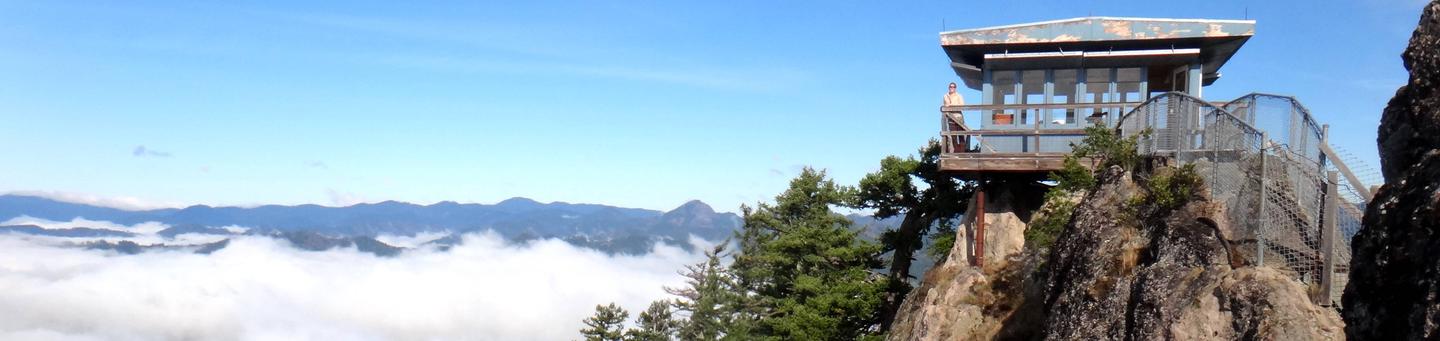
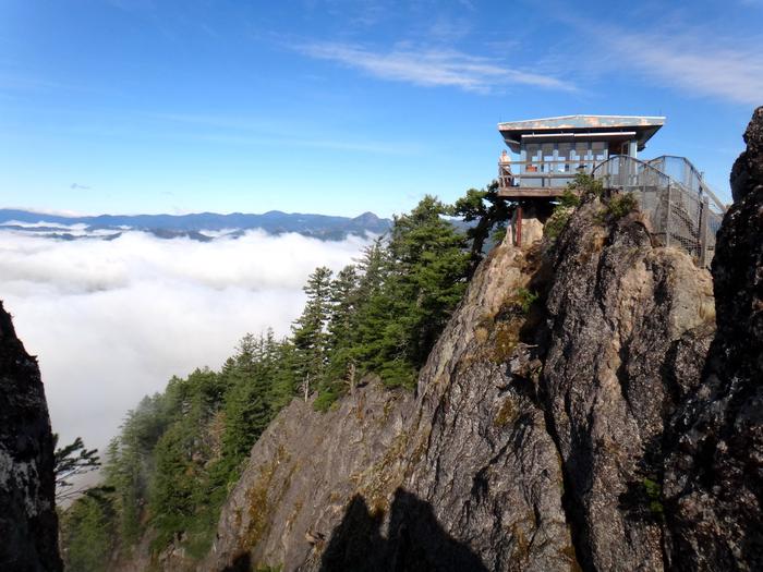
ACKER ROCK LOOKOUT Campground
List of CampsitesOverview
Perched atop the edge of a rocky cliff in the Umpqua National Forest, Acker Rock Lookout offers visitors a unique lodging experience with spectacular panoramic views of the South Umpqua watershed in southwest Oregon. Still used in active fire detection today, the lookout was placed on the rocky cliff via helicopter in the 1960's. Before the advent of airplane surveillance for fire detection, there were more than a dozen lookouts on the Tiller Ranger District. Today Acker Rock and Pickett Butte are the only remaining lookouts on the District. The lookout tower is generally available for reservation from August 1st thru November 15th (depending on snow). High clearance all-terrain vehicles are recommended for travel to this site, and guests must bring several of their own amenities. The lookout is not rented during the winter months due to wind and snow weight restrictions on the building. Visitors should keep in mind everything must be packed in via a moderately steep 0.4-mile hike along a forested trail to reach the lookout.Recreation
The panorama includes landmarks on the Rogue-Umpqua Divide; on a clear day you can see mountains on the Willamette, Rogue, and Deschutes River watersheds and Crater Lake Rim. Overlooking the Umpqua River and several of its tributaries, the lookout is a delightful setting for hiking, birding and wildlife viewing. Seasonal changes envelope the area as snowmelt gives rise to spring flowers and vivid autumn colors bring with it numerous recreation opportunities.For a day trip, guests may enjoy a scenic drive along a portion of the 172-mile Rogue-Umpqua National Scenic Byway or a mountain hike into the Rogue Umpqua Divide wilderness on over 100 miles of trail.
Facilities
The 12-foot by 12-foot, one-room lookout is furnished with a single bed, a small table and chair, and is equipped with a propane fueled wall heater, lanterns, cooking stove with oven and a refrigerator (propane is provided). A composting toilet is located at the lookout site. There is no water at the site, so visitors must bring plenty for drinking, cooking and washing. Potable water is available at a spigot in front of the Tiller Ranger Station office (45 minute drive). Guests must supply their own food, cooking utensils, sleeping bags, sleeping pads, towels, dish soap, matches, cooking gear, toilet paper and garbage bags. Although propane lighting is available, bringing an additional light source is recommended.Natural Features
Unique volcanic and sedimentary rock outcroppings and dense conifer forests define the landscape, giving way to sub-alpine meadows and summer wildflowers in the higher elevations. The rock formation on which the lookout building sits is itself a magnificent feature. Sheer cliffs drop off for several hundred feet on the west and south sides.The translation of the word "Umpqua," meaning "thundering waters," defines the area. High mountain lakes, heart-stopping rapids, peaceful ponds and thundering waterfalls await visitor.
Nearby Attractions
Opportunities for fishing are within 10 miles of the lookout.HEMLOCK CABIN Permit
Overview
Hemlock Butte Cabin is a very primitive backcountry winter experience, and guests who stay here should be experienced in winter backcountry travel. It is this remoteness that makes the 4-mile ski or snowshoe to the cabin worth the effort. The cabin was built by the Edelweiss Ski Club in 1990 and has room for 12 people. There are often occupants from several different groups staying in the cabin at the same time. Only a few basic amenities are offered, so guests should be prepared to pack in most of their own supplies and gear.Recreation
Several winter recreation trails crisscross the area. The Hemlock Butte Trail, which is used to access the cabin, is a challenging backcountry ski experience. Skiers on this trail can enjoy views of Mount Thielsen, Mount Bailey and even the rim of Crater Lake on a clear day. Advanced skiers can make the difficult trek up Mount Bailey, a 2-mile trip from the cabin with an elevation gain of 3,300 feet. Skiers should make sure to have proper backcountry equipment and be aware of avalanche dangers .Facilities
The cabin is a three-story A-frame with a wood stove for heating the cabin and melting snow. The ground floor serves as the living area with benches around the stove. The middle floor is the sleeping area. The top floor is available for additional sleeping space via a wall-mounted ladder. The only provided cooking pot is for melting snow. Firewood is provided through Edelweiss Ski Club volunteers and U.S. Forest Service staff, but guests are asked to use it conservatively. An outhouse with vault toilet is located near the cabin. No electricity or drinking water is provided. Guests typically melt snow to use for drinking, cooking and washing. The cabin does not have beds. Guests should bring sleeping bags and pads, a camp stove, cookware and utensils, lanterns or flashlights, a first aid kit, matches, extra toilet paper and garbage bags. All trash and food should be packed out, and guests are expected to clean the cabin before leaving.Natural Features
The cabin is situated at the base of Southern Oregon's Mount Bailey in Umpqua National Forest, near scenic Diamond Lake. Mount Bailey is a popular ski destination, averaging 600 inches of snow per year and boasting 6,000 acres of ideal skiing terrain. Mount Bailey, part of the Cascade Mountain Range, is a shield volcano topped with a 2,000-foot tephra cone. The mountain is heavily forested with pine at lower elevations, which gives way to hemlock and fir at higher elevations. The peak rises above treeline and crests at 8,363 feet.Charges & Cancellations
A $10.00 service fee will apply if you change or cancel your reservation. Late cancellations are subject to additional fees. For full details see NRRS Reservation Policy.MUSICK GUARD STATION Campground
List of CampsitesOverview
Musick Guard Station is located in a remote setting in southwestern Oregon, offering visitors a glimpse into a historic mining community in Umpqua National Forest. Situated atop a narrow forested ridge between Fairview Peak and Grouse Mountain, the guard station and outbuildings were constructed by the Civilian Conservation Corps in 1934 to provide fire protection to the Bohemia Mining district. Listed on the National Register of Historic Places, Musick Guard Station became an important public contact point and administrative center for the Forest Service. Later it was used as summer barracks for trail crews and firefighting crews. The Guard Station was named after the nearby Musick Mine, a major gold producing mine in the late 1800s and early 1900s. Today the guard station continues to offer visitors a unique lodging experience and plenty of opportunities for relaxation and recreation. This site is located in National Forest System lands. These sites are popular with the recreating public so you may find visitors interested in the area and the facilities. While you do not have to let them inside the facility they are allowed to be in the area.Recreation
For hiking and sightseeing, the nearby Bohemia Mountain Trail leads up a steep grade to the rocky summit of Bohemia Mountain, the highest point on the Cottage Grove Ranger District. Just east of the summit along a ridgeline hikers will be treated to dramatic views of the Cascade mountains and a wildflowers blooming along rocky outcrops and bluffs in late June through early August. For history buffs and fortune seekers, Musick Mine, one of the most productive gold mines in the district during the late 1800s and into the early 1900s, is a point of interest not to be overlooked. The area is named after James "Bohemia" Johnson, a mountaineer and prospector, who discovered gold-bearing quartz in 1863. The discovery created much short-lived excitement in the valley, but settlers soon realized the gold had to be extracted from the rock by machinery, not panned from the many streambeds, and by 1910 most of the ore had been removed. Some mining continues today.Facilities
The main floor of the two-story guard station features a central room with an adjoining kitchen and bedroom. The upstairs bunkroom provides additional sleeping quarters. It is furnished with two double wooden platform beds and four bunk beds without mattresses, a table with chairs, a wood stove for heat, and wood cook stove and oven. Outside, a picnic table, campfire ring, and vault toilet are provided. An area for pitching a tent is also on site.There is no refrigerator, water or electricity available at the site. Guests must bring water necessary for drinking, cooking and washing. Guests must also bring a lantern or other reliable light source, cooking utensils, sleeping bags, sleeping pads, towels, dish soap, matches, cooking gear, toilet paper, first aid kit and garbage bags. Firewood may be available, however the supply cannot be guaranteed, and guests are encouraged to bring their own.
Natural Features
Musick Guard Station is surrounded by rugged summits up to 6,000 feet in elevation, and steep, heavily forested slopes of fir, spruce and hemlock.Nearby Fairview Peak, located in the heart of the Bohemia Mining District at an elevation of 5,933 feet, provides an excellent panoramic view of the surrounding area. On a clear day, the Cascade Range peaks can be viewed from Mt. Hood to the north and Mount McLoughlin to the south.
Large mammals such as elk, deer, black bear, and cougar, as well as the smaller residents like squirrels, fox, raccoons and bats, are supported by the area's diverse forest habitats.
Nearby Attractions
Visitors may want to take some time to visit nearby Crater Lake National Park for a glimpse into the area's fascinating geological and cultural history.STEAMBOAT BALL FIELD GROUP SITE Campground
List of CampsitesOverview
Steamboat Ball Field Group Site sits near the banks of the North Umpqua River under a canopy of forest. With access to a multitude of recreational opportunities, including a ball field, river access and a handful of trailheads within the area, this campsite offers an ideal setting for group camping and recreation excursions.Recreation
Fishing, hiking and swimming top the list of activities at this site. With wide open spaces, along with a ball field and horseshoe pits, this campground offers visitors plenty of recreational opportunities. A forested bank and mountainous backdrop to the North Umpqua River is a perfect setting for both swimmers braving its cold, refreshing waters, and for anglers fishing for rainbow, steelhead and cutthroat trout. A picnic shelter and large grill provide the perfect setting for gathering after a day of activity or relaxation.Facilities
This campground has one large reservation only group site able to accommodate up to 100 people and a maximum of 20 vehicles. The site is equipped with picnic tables, campfire rings, grills and accessible vault toilets. A baseball field, horseshoe pits and picnic shelter are available for use.Natural Features
Visitors to Umpqua National Forest are often taken aback by the unique landscapes of southwestern Oregon. Explosive geologic events have shaped the distinctive landscape on the nearly 1 million-acre forest, and provide spectacular scenery as well as an abundance of natural and cultural resources. Flowing adjacent to this campground is the North Umpqua River, a tributary of the Umpqua River, and a designated National Wild and Scenic River. Possessing remarkable values related to fisheries, culture, recreation and scenery, the North Umpqua River is renowned for its emerald green waters and fly fishing. Several designated wilderness areas provide undisturbed solitude for visitors. Encompassing 19,100 acres, Boulder Creek Wilderness offers dense old-growth forests and steep terrain that tower above Boulder Creek, which runs through the heart of the wilderness. Diverse ecosystems support a wide range of habitat for wildlife common to the area. From eagles and owls, to salamanders and salmon, these species, along with many others, depend on surrounding undeveloped wilderness, clean streams, and diverse forests to live.Nearby Attractions
Hikers will enjoy the 79-mile North Umpqua Trail which begins in the Mount Thielsen Wilderness at Maidu Lake and follows the river to the confluence with Rock Creek. Sections of this trail are also open to mountain bikes and stock. There are opportunities for fishing within 1 mile of the campground, and within 10 miles a non-motorized boat ramp, and places for swimming and berry picking.WOLF CREEK GROUP SITE Campground
List of CampsitesOverview
Wolf Creek Group Campground is set near the banks of Little River with a large open area hemmed in by a canopy of forest, providing a perfect setting for family reunions, celebrations or group getaways.Recreation
Running nearly parallel to the North Umpqua River is the popular North Umpqua Trail. This 79 mile National Recreation Trail offers a trek for every ability. Mountain bikers won't feel left out as there are many opportunities to test your riding skills. Several trailheads can be accessed in the vicinity of the campground. In most places the trail travels near the river, allowing you to hike or ride with the sound of rapids and picturesque views spurring you on. Passing through lush forests, old-growth trees, and rocky bluffs, you will also occasionally get a bird's eye view of the river.Facilities
This campground has one large reserve only site able to accommodate up to 150 people. The site is equipped with several picnic tables, a shelter with a fireplace, campfire rings, grills, flush toilets and drinking water. Access to the Little River is within walking distance. A ball field, volleyball court and horseshoe pits are also on-site.Natural Features
Visitors to Umpqua National Forest are often taken aback by the unique landscapes of southwestern Oregon. Explosive geologic events have shaped the distinctive landscape on the nearly 1 million-acre forest, and provide spectacular scenery as well as an abundance of natural and cultural resources. Diverse ecosystems support a wide range of habitat for wildlife common to the area. From eagles and owls, to salamanders and salmon, these species, along with many others, depend on surrounding undeveloped wilderness, clean streams and diverse forests to live.Nearby Attractions
Visitors may want to take some time to visit nearby Yakso Falls and Grotto Falls; both are easy hikes which show how varied waterfalls can be. Visitors also enjoy the 172 miles of diverse river and mountain landscapes along the Rogue-Umpqua National Scenic Byway. The scenic drive travels from rolling oak-covered hills and towering coniferous forests to roaring white water rapids and incised intercanyon lava flows. The highway travels alongside the Upper Rogue and North Umpqua Wild and Scenic Rivers that contain world-class fisheries.Deer Flat Group Site (Horseshoe Bend Campground) Campground
List of CampsitesOverview
Deer Flat Group Campground is situated in a stand of old growth Douglas fir, sugar pine and deciduous trees, near the banks of the scenic North Umpqua River. The campground offers a perfect setting for large family and group camping excursions.Recreation
Deer Flat is a prime location for hiking, fishing, biking, and boating in summer and early fall. The North Umpqua River, adjacent to this campground, drains portions of the western side of the Cascade Range. Almost 34 miles of this river have been designated as a Wild and Scenic River. Renowned for outstanding salmon and steelhead fishing and exhilarating whitewater challenges, the North Umpqua River offers an ideal setting for many recreational pursuits. The Illahee Flat Trail descends from the nearby Horseshoe Bend Campground and continues from Illahee Flat to the Jessie Wright Segment of the North Umpqua Trail. The 79 mile North Umpqua Trail parallels the river and offers visitors challenging hiking and mountain biking experiences.Facilities
This large, reserve only site is able to accommodate up to 70 people. The site is equipped with several picnic tables, campfire rings, grills, flush toilets and drinking water. Roads and spurs in this campground are paved. Access to the North Umpqua River is within walking distance.Natural Features
Visitors to Umpqua National Forest are often taken aback by the unique landscapes of southwestern Oregon. Explosive geologic events have shaped the distinctive landscape on the nearly 1 million-acre forest, and provide spectacular scenery as well as an abundance of natural and cultural resources. The translation of the word, "Umpqua," meaning "thundering waters," defines the area. High mountain lakes, heart-stopping rapids, peaceful ponds and thundering waterfalls, including the 272-foot Watson Falls on the North Umpqua Highway, offer visitors plenty of pastimes. Diverse ecosystems support a wide range of habitat for wildlife common to the area. From eagles and owls, to salamanders and salmon, these species, along with many others, depend on surrounding undeveloped wilderness, clean streams and diverse forests to live.Nearby Attractions
Opportunities for hiking, mountain biking, boating and fishing are within 1 mile of the campground. Access to climbing routes is within 10 miles. Visitors may want to take some time to visit nearby Crater Lake National Park, the only national park in Oregon! The amazing Crater Lake area offers a glimpse into the volcanic history of the area. Experience 172 miles of diverse river and mountain landscapes along the Rogue-Umpqua National Scenic Byway. Travel from rolling oak-covered hills and towering coniferous forests, to roaring white water rapids and incised intercanyon lava flows. The highway travels alongside the Upper Rogue and North Umpqua Wild and Scenic Rivers that contain world-class fisheries.PICKETT BUTTE LOOKOUT Campground
List of CampsitesOverview
Perched atop Pickett Butte at an elevation of 3,200 feet, this lookout offers visitors a unique lodging experience in Umpqua National Forest in southwest Oregon. After climbing 40 feet up on a very narrow steep stairway to the one-room structure, guests are rewarded with panoramic views of the entire Jackson Creek Drainage and much of the lower elevation lands around the town of Tiller. The original lookout was 25 feet tall and built in 1934. In 1948 the tower was replaced with the current flat top structure. The tower is available for reservations October 15 through July 15 (lookout is utilized for fire season during the summer months). The roads to the lookout are not plowed, nor are they maintained for passenger cars. High clearance or four wheel drive vehicles are recommended for travel to this site, and guests must bring several of their own amenities. Please be aware that while very uncommon, during winter months guests may need to snowmobile, ski or snowshoe up to four miles to reach the lookout.Recreation
Hiking, birding and wildlife viewing are popular among guests. Seasonal changes envelope the area as snowmelt gives rise to spring flowers and vivid autumn colors welcome a landscape dusted with snow. Guests may enjoy a day of scenic driving along a portion of the 172-miles Rogue-Umpqua National Scenic Byway. Mountain and river scenery unfold along the highway, showcasing everything from rolling oak-covered hills and towering coniferous forests to roaring white water rapids and incised inter-canyon lava flows. Swimming at the Three C Rock Picnic Area, about 7 miles from the lookout, is also a refreshing way to spend a warm summer afternoon.Facilities
The lookout cabin is a 12 x 12 room, set 40 feet above the ground. It is furnished with a single bed, and a small table and chair, and is equipped with a propane heater, lanterns, cooking stove with oven and a refrigerator (propane is provided). A vault toilet is located at the lookout site. There is a pulley system available to transport items from the ground to the lookout (use at your own risk). There is no water at the site, so visitors must bring plenty for drinking, cooking and washing. Potable water is available at a spigot in front of the Tiller Ranger Station office (20 minutes away via car). Guests must bring several of their own supplies, including food, cooking utensils, sleeping bags, sleeping pads, towels, dish soap, matches, cooking gear, toilet paper and garbage bags. There is no trash service. Pack out all food and garbage.Natural Features
In 1898, homesteader William T. Pickett rode into this area on horseback and decided to stay and build a life and home. Perched atop the butte named after him, the Pickett Butte Lookout offers a view of the entire Jackson Creek Drainage and much of the lower elevation lands around the town of Tiller. The Rogue-Umpqua Divide, south and east of Pickett Butte, has scenic peak landmarks, which are capped with snow until early summer.Water is abundant in streams and a handful of lakes in the area, and diverse plant communities provide habitat for abundant wildlife ranging from hummingbird to black bear.
Learn more about bear safety.
Nearby Attractions
Visitors may want to take some time to visit nearby Crater Lake National Park for a glimpse into the area's fascinating geological and cultural history.BUTLER BUTTE CABIN Campground
List of CampsitesOverview
This facility is closed.
Recreation
Facilities
Natural Features
Nearby Attractions
.
WHISKY CAMP GUARD STATION Campground
List of CampsitesOverview
Whisky Camp, built in the 1940s, was the summer home of a fireguard whose primary duties were to fight and prevent fires, serve as a relief lookout, and perform maintenance on phone lines and trails. Located in the Tiller Ranger District in southwestern Oregon, the cabin now offers relaxation and recreation for visitors throughout the year. Four-wheel drive vehicles are recommended for travel to this site, and guests must bring several of their own supplies. Please be aware that in winter months guests may need to snowmobile, ski or snowshoe up to five miles one-way to reach the cabin. Consider this winter travel advisory when making your reservations.Recreation
The Bunchgrass, Elkhorn and Beaver Creek trails leave from Whisky Camp for hiking or horseback riding. Additional activities include mountain biking, birding, wildlife viewing and photography. In the winter guests enjoy snowshoeing, cross-country skiing and snowmobiling (trails may be closed for public safety due to wildfire damage. Please call the Tiller Ranger Station for current updated information).Facilities
This two-room cabin is equipped with two single beds and two single roll-out beds, both with foam pad mattresses. Amenities inside the cabin include a wall heater, lights, a cook stove with oven and a refrigerator, all powered by propane, which is provided. Provided outside, are picnic tables, a campfire ring, an outdoor grill (not propane) and a vault toilet. An area for pitching a tent is also on-site. Guests must bring several of their own supplies. The cabin does not have food, cooking utensils, sleeping bags, towels, dish soap, matches, cooking gear, toilet paper or garbage bags. Firewood may be available, but the supply cannot be guaranteed. There is no water available at the site. Guests must bring water necessary for drinking, cooking and washing. Potable water is available at a spigot in front of the Tiller Ranger Station office (45 minutes away).. Although propane lighting is available, bringing an additional light source is recommended.Natural Features
At an elevation of 3,800 feet, this quaint, red-planked, cedar-roofed cabin is tucked beneath a dense forest of cedar, pine and fir trees. Nicely shaded and secluded, an occasional brilliant shaft of sunlight breaks through the canopy. Large mammals such as elk, deer, black bear and cougar, as well as the smaller residents like squirrels, fox, raccoons and bats, are supported by the diverse forest habitat in the area. Learn more about bear safety.Nearby Attractions
Visitors may want to take some time to visit nearby Crater Lake National Park for a glimpse into the area's fascinating geological and cultural history.Guests might also enjoy a day of scenic driving along the Rogue-Umpqua National Scenic Byway, located within driving distance of the cabin. Landscapes unfold along the highway, showcasing everything from rolling oak-covered hills and towering coniferous forests to roaring white-water rapids and incised inter-canyon lava flows.
Charges & Cancellations
Refunds are not given for inclement weather.
RUJADA DAY USE PICNIC AREA Campground
List of CampsitesOverview
Rujada Day Use Picnic Area is set along the banks of Layng Creek, with a large, open grassy area amidst a scattering of Douglas fir. Rujada is a perfect setting for family reunions, parties or group getaways.Recreation
In addition to being a prime location for hiking and biking in summer and early fall. The large grassy field is perfect for group activities or sports, and a playground and horseshoe pit are also provided on-site.Hikers will enjoy a moderately challenging hike on Swordfern Trail, leaving from the historic Civilian Conservation Corps Campground Register booth, located in the Rujada Picnic Area. The trail parallels the south side of Layng Creek, traveling through a stand of second growth Douglas fir and lush swordfern understory, then climbs to an abandoned logging road. Eventually it loops back to the Rujada Picnic area, or continues on the logging road and back into the camping loop.
In autumn, visitors will be treated to the brilliant fall colors of the hardwood trees along Layng Creek.
Facilities
This day use area has two reservable picnic sites. Each site can accommodate up to 30 people, and groups of up to 60 may reserve both sites. The sites are equipped with picnic tables and grills. Flush toilets and drinking water are provided.Natural Features
Visitors to Umpqua National Forest are often taken aback by the unique landscapes of southwestern Oregon. Explosive geologic events have shaped the distinctive landscape on the nearly 1 million-acre forest, and provide spectacular scenery as well as an abundance of natural and cultural resources. The translation of the word, "Umpqua," meaning "thundering waters," defines the area. High mountain lakes, heart-stopping rapids, peaceful ponds and thundering waterfalls, including the 272-foot Watson Falls on the North Umpqua Highway, provide plenty of pastimes for visitors. Diverse ecosystems support a wide range of habitat for wildlife common to the area. From eagles and owls, to salamanders and salmon, these species, along with many others, depend on surrounding undeveloped wilderness, clean streams and diverse forests to live.Nearby Attractions
Nearby are three spectacular waterfall trails. Spirit Falls is a short 0.4-mile, more difficult hike to a 60’ waterfall. Moon Falls is an easy, 0.5-mile hike to a 125’ cascading waterfall. Pinard Falls is a 0.6-mile, more difficult hike to a 105’ waterfall. All three hikes are within 10 miles of the campground and can be done within a single day. Visitors enjoy taking a picnic lunch and eating at the base of Moon Falls at a picnic table made and installed by a modern day Conservation Corps crew.South Shore Boating Site (Diamond Lake) Facility
Near the Broken Arrow Campground, the South Shore boating site is a beautiful way to enjoy Diamond Lake. There are also picnic facilities as well as parking to access the John Dellenback Trail.
Soda Springs Traihead Facility
Provides access to: Soda Springs Trail #1493 which accesses Boulder Creek Wilderness. Soda Springs Trail heads north to meet Bradley Trail #1491.
This is located below the Soda Springs Reservoir Dam at the powerhouse. There is a restroom and parking.

Steamboat Inn Facility
42705 North Umpqua Highway
Idleyld Park, OR 97447
1-800-840-8825 or 1-541-498-2230
Steamboat Inn, an equal opportunity service provider, is operated under special-use permit administrated by the USDA Forest Service, Umpqua National Forest.
See www.thesteamboatinn.com for more information.
Ash Flat Campground Campground
List of CampsitesTucked into a forest of mixed conifers and hardwoods, Ash Flat Campground provides shaded campsites for a relaxed getaway any time of the year. Beaches and beautiful downstream views courtesy of the South Umpqua River are just a few seconds away, so bring your bathing suits!
Facilities
- 4 campsites with picnic tables and fire pits
- No drinking water
- Vault toilet
- Garbage disposal


Lemolo Lake Trailhead Facility
Enjoy a beautiful hike around the picturesque Lemolo Lake, which is a reservoir managed as part of the North Umpqua Hydroelectric Project.
Bradley Trailhead Facility
Provides access to: Bradley Trail #1491 which enters the south end of Boulder Creek Wilderness. Bradley Trail leads to Pine Bench, a popular spot within the wilderness, and connects with Boulder Creek Trail #1552.
Acker Rock Facility
Acker Rock is located on the Tiller Ranger District of the Umpqua National Forest. There are 20 established routes on Acker that range in difficulty of 5.5 PG to 5.10d. Some of the most popular of these are the Peregrine Traverse (Oregon’s longest II to III 5.6 climb, 9 pitches) and Eagle’s Dare (III 5.9, 8 pitches). In addition, Oregon’s longest multiple rappel from the ridge of Acker Rock Lookout to the base of Eagle’s Dare is close to 550 feet in length. This is some of Southwest Oregon adventure climbing at its best.
Gear
- A 60-meter rope is recommended for all routes in this area.
- A minimum of 2 ropes per party is encouraged, as pitches will generally average 150 to 200 feet in length.
- All routes are protected with fixed anchors; however you may find it desirable to carry a light rack of cams to supplement the occasional run-out.
- Most routes, except the Peregrine Traverse, will not have chains at belay anchors, so carry extra webbing.
Cottage Grove Ranger District Facility
Enjoy lush mixed conifer forests, mountain creeks, and waterfalls while visiting the northernmost ranger district of the Umpqua National Forest. Cottage Grove Ranger District offers opportunities for camping, hiking, mountain biking, fishing, trail riding, and even renting an old Guard Station.
North Umpqua Ranger District Facility
Located in the heart of the forest and centered around the beautiful North Umpqua River, North Umpqua Ranger District offers up a cornucopia of recreational activities: fishing, rock climbing, mountain biking, horse riding, nature viewing, OHV trail riding, hiking, and boating. We know—it’s exciting.
North Umpqua Wild and Scenic River Facility
The 33.8-mile Wild and Scenic section of the North Umpqua River offers exciting white water boating. Permits are not required for non-commercial private boats. Commercial outfitters are available for hire. A 5-mile section upstream of Bogus Creek Campground is closed to boating between July 15 and October 31 to minimize conflicts with anglers. Also, between July 1 and the end of October, boating is restricted before 10 a.m. and after 6 p.m. to lessen conflicts with anglers.
Detailed information regarding white water boating on the North Umpqua Wild and Scenic River is available in a brochure entitled “North Umpqua River Recreation Guide,” available from the North Umpqua Ranger District, Colliding Rivers Visitor Center in Glide, and at several boat launches along the river. The brochure provides information on boat launches and various rapids classification found within the Wild and Scenic River. The brochure also covers river etiquette, safety, and information on campgrounds and other recreational opportunities along the North Umpqua River corridor. The rapids of the Wild and Scenic section have been rated following the International Scale of River Difficulty as follows:Class II+ (9 Rapids): Rapids with waves up to 3 feet high; some maneuvering is required to avoid dangerous situations Class III (19 Rapids): Rapids with higher, irregular waves often capable of swamping an open canoe. Narrow passages may require complex maneuvering and scouting from shore. Class IV (1 Rapid): Long, difficult rapids with constricted passages that often require precise maneuvering in very turbulent waters. Scouting from shore is often necessary and conditions make rescue difficult. Generally not possible for open canoes. Scouting from shore. Class V (1 Rapid): Extremely difficult. Life may be endangered in the event of a mishap. The one Class V rapid is deadline falls located within 1/3 mile of Rock Creek and the bottom of the designated Wild and Scenic section. Boaters takeout upstream of deadline falls. Difficulty of the rapids is primarily dependant on water flow levels. Most rapids increase in difficulty with higher water. However, several rapids on the North Umpqua Wild and Scenic River become more difficult as the water level decreases.
River flows are available daily from a stream gauge downstream of Steamboat Creek. Flows are available from the Douglas County web site www.co.douglas.or.us The river difficulty ratings do not reflect potentially dangerous conditions that may be present when trees, snags, and slides enter and become part of the ever-changing river. It is your responsibility to scout and familiarize yourself with the sections of the river you are planning to float. There are several runs possible, and the North Umpqua River Recreation guide is an excellent planning tool for first time visitors.Deadline Falls is rated a Class V rapid. Boaters takeout upstream of this falls.
Abbott Butte Trailhead Facility
Nestled in Huckleberry Gap, Abbott Butte Trailhead provides access to high elevation trails that traverse the ridge top of the Rogue-Umpqua Divide.
Provides access to: Abbott Butte Trail #1470A and southern access to Rogue-Umpqua Divide Trail #1470 which access Rogue-Umpqua Divide Wilderness.
Fish Lake Trailhead Facility
Provides access to: Fish Lake Trail #1570 which enters Rogue-Umpqua Divide Wilderness.
Fish Lake Trail intersects Beaver Swamp #1569, Indian Trail #1573 and Lakes Trail #1578.
Facilities include: Stock off loading ramp, two hitch rails, highline poles, and manure bin. Easy access fo Fish Lake Creek for stock water.
Boulder Creek Trailhead Facility
Provides north access to: Boulder Creek Trail #1552 which travels south through Boulder Creek Wilderness to meet the North Umpqua River at the southern border of the wilderness at Boulder Flat Campground.
Cougar Butte Trailhead Facility
This trailhead provides access to Cougar Butte Trail #1432 and Rogue Umpqua Divide Trail #1470, which access Rogue-Umpqua Divide Wilderness.
Rogue-Umpqua National Scenic Byway Facility
Rogue - Umpqua National Scenic Byway
Cripple Camp Trailhead Facility
Trail from this trailhead pass through stands of large, old-growth Douglas fir.
Provides access to: Cripple Camp Trail #1435, which accesses Pup Prairie Trail #1434, Acker Divide Trail #1437 and Cripple Camp Shelter.
These trails are within Rogue-Umpqua Divide Wilderness.
Accessibility: From the trailhead, flat trail grades provide an accessible opportunity into Wilderness. Some persons with disabilities may need assistance, assistance is recommended.
Rogue-Umpqua Divide Wilderness: Umpqua Facility
The 35,701 acre Rogue-Umpqua Divide Wilderness is located in southwest Oregon, ten miles west of Crater Lake National Park. Elevations range from 3000 to 6800 feet along the divide between the Rogue and Umpqua Rivers. Geologic history has created many unique volcanic and sedimentary rock outcrops. Dense conifer forest gives way to a mosaic of big trees and sub-alpine meadows in the higher elevations.
Meadow wildflowers are abundant in summer and diverse plant communities provide habitat for everything from hummingbirds to black bears. Water is abundant in streams and a handful of lakes. About 100 miles of trails access the area, providing loop opportunities and ridgetop vistas. Nearly all trails in the Rogue-Umpqua Divide pass through sub-alpine meadows. For those who want to experience large old-growth forests, Acker Divide Trail #1437 and Cripple Camp Trail #1435 have these qualities.
Snow accumulations are transitory below 4000 feet and the entire area is usually snow free by mid-July.
- Key access points: Trailhead and trail information.
Deer Leap Facility
Deer Leap is a large andesitic columnar rock formation visible from Toketee Schoolhouse above the North Umpqua River. There is one established climb on Deer Leap (III, 5.9, A1). The route is protected with fixed anchors and belays. There are no chains at belays, and there is a short 30-foot section of ¼ inch aid climbing though a band of choss. This route has only had one ascent.
Mt. Thielsen Wilderness: Umpqua Facility
Mt. Thielsen Wilderness encompasses 54,914 acres and runs along the crest of the Cascades 80 miles east of Roseburg and just north of Crater Lake National Park. Elevations range from 5,000' to the 9,182' summit of Mount Thielsen. Born of the same volcanic activity that created Crater Lake, this is the land of fire and ice.
Much of the Mount Thielsen Wilderness is made up of high alpine forests and open meadows. The terrain is moderate but becomes very steep toward the crest of the Cascade Mountains. Timberline stands at about 7,200 feet, just above a forest of mountain hemlock and fir mixed with whitebark pine. Lodgepole pine dominates the vegetation at lower elevations. The many streams in the area carry a substantial amount of snowmelt in spring.
The Pacific Crest National Scenic Trail winds through the Mount Thielsen Wilderness for 26 miles along the summit of the Cascade Range. For a more serene wilderness adventure, hike into Lake Lucille or Maidu Lake on the North Umpqua Trail #1414. The trail passes over deep pumice that was deposited when Mt. Mazama erupted to form Crater Lake. The famed North Umpqua Wild and Scenic River begins at Maidu on its long trek to the Pacific Ocean.
For the more experienced, the climb to the top of 9,182 foot Mt. Thielsen is a nice challenge. The Mount Thielsen Trail enters for approximately five miles from the west to rise above the tree line and, after 200 feet of hand-over-hand scrambling, finally reaches to within 80 feet of the summit and a breathtaking view. The summit itself requires a short technical climb. Sitting at the top of the sharp volcanic pinnacle, it is easy to see why Thielsen has been called "the lightning rod of the Cascades.
Limpy Rock Facility
Need a description of Limpy Rock here...
Three Lakes Sno-Park Facility
Three Lakes Sno-Park provides winder recreationists opportunities for down-hill skiing, snowmobile riding snow shoeing and cross-country skiing. Ask the Diamond Lake Ranger District for the latest maps for Nordic and snowmobile trails. Nordic skiing from the Three Lakes Sno-Park includes 2.3-mile Silent Creek and 3.6-mile Hemlock Butte trails. Hemlock Butte Trail is also a snowmobile trail for the first two miles until it reaches the Bailey Connect.
Tiller Ranger District Facility
With its sheer cliffs, dense conifer forests, summer wildflowers, and sub-alpine meadows, Umpqua National Forest’s southernmost ranger district has offerings for hikers, bikers, climbers, and horseback riders. This district also borders the beautiful Rogue-Umpqua Divide Wilderness.
Castle Creek Trailhead Facility
This trailhead provides access to Castle Creek Trail #1576 which enters Rogue-Umpqua Divide Wilderness. This is an undeveloped trailhead that has no amenities available. There is space for about three cars, but there may not be enough room for a horse trailer.

Myrtle Creek-Canyonville Tour Route Facility
This State of Oregon designated Tour Route loop explores a 68-mile section of Southern Oregon. It's so rich in natural beauty and fascinating history, pack a lunch and make it an all-day adventure. This loop route begins and ends in Myrtle Creek. The southern part of the route is along the South Umpqua River and goes past historic homes and buildings, bountiful farms, then the middle part of the route is a forest road through stands of Douglas fir, and the northern portion goes through hills dotted with cattle, sheep and wild turkeys. The roadsides are painted with wildflowers in spring and colored leaves in fall. For more information, call the Myrtle Creek Area Chamber of Commerce at (541) 863-3037 or the Tiller Ranger District at (541) 825-3100.
You can also visit the Travel Oregon web site for more information.
Boulder Creek Wilderness Facility
At 19,886 acres, Boulder Creek Wilderness is the smallest on Umpqua National Forest. It is located 50 miles east of Roseburg, OR. Small waterfalls and rapids connect the series of quiet pools that make up Boulder Creek, a tributary of the North Umpqua River, which runs through the heart of the area.
The rocky monoliths and outcroppings attract -and challenge- technical rock climbers, especially in the southern portion's Umpqua Rocks Special Interest Geologic Area.
Ponderosa pines flourish on Pine Bench, near the southern end of the Wilderness, and are thought to be the largest such stand of this kind this far northwest of the crest of the Cascade Mountains. Ponderosa pine or "yellow-bellies" are often resistant to fire because of their thick layer of bark.
The Spring Fire in 1996 and the Rattle Fire in 2008 burned most of this wilderness area. Expect rapid brush growth and persistent blowdown on the 10 miles of maintained trails in the years to come.
- Key Access Points: Trailhead and trail information.
BOGUS CREEK CAMPGROUND Campground
List of CampsitesOverview
Bogus Creek Campground is situated in a stand of old growth Douglas fir, cedars, and deciduous trees, among many flowering shrubs and native species. Its proximity to the Wild & Scenic North Umpqua River makes this campground the perfect get away.Recreation
Bogus Creek Campground is located in a prime location to participate in many outdoor endeavors such as hiking, mountain biking, fly fishing, and whitewater rafting to name a few. If nature photography or wildlife viewing are your passion, you will be in no better place to capture Mother Nature's splendor through your lens or sit along the river to see the flight of the majestic bald eagles that call the North Umpqua River home. The North Umpqua River, just across the highway from this campground, offers many recreational pursuits and river access is made easy with a raft launch located across from the campground as well. Renowned for outstanding salmon and steelhead fishing and exhilarating whitewater challenges, the North Umpqua River offers an ideal setting for many recreational pursuits.Facilities
This 14 site campground offers potable water, accessible flush toilets and hand washing sinks. Each site is equipped with a picnic table and fire ring and some sites offer a barbeque grill. Roads and spurs in this campground are paved. Trash facilities are available within the campground. Access to the North Umpqua River is within walking distance. A campground host is on site during peak season. All sites are reservable, unreserved sites will be made available on a first-come first-serve basis.Natural Features
Visitors to the Umpqua National Forest are often taken aback by the unique landscapes of southwestern Oregon. Explosive geologic events have shaped the distinctive landscape on the nearly 1 million-acre forest, and provide spectacular scenery as well as an abundance of natural and cultural resources.The translation of the word "Umpqua," meaning "thundering waters," defines the area. High mountain lakes, heart stopping rapids, peaceful ponds and thundering waterfalls, including the beautiful Toketee Falls, offer visitors plenty to see and do.
Nearby Attractions
The popular 79 mile North Umpqua Trail is nearby and can be accessed easily from the campground from the Wright Creek or Mott Trailheads. Within the campground, you can walk along the Riverview Trail and treat yourself to amazing views of the river. Opportunities for mountain biking and whitewater rafting are within 10 miles. This campground sits along the route of the Rogue-Umpqua National Scenic Byway. The Byway offers 172 miles of diverse river and mountain landscapes that traverses through the Umpqua and Rogue River valleys. Travel from rolling oak covered hills and towering coniferous forests, to roaring white water rapids and incised inter-canyon lava flows. The highway travels alongside the Upper Rogue and the Wild & Scenic North Umpqua River.TOKETEE GROUP SITE Campground
List of CampsitesOverview
The North Umpqua Wild and Scenic River pauses at Toketee reservoir providing a secure home for a wide variety of wildlife. Here beaver and otter make their homes. Visitors are sometimes treated to seeing and hearing the beaver's tail slaps. Great blue heron and kingfishers are joined in fall and winter by ducks, geese, and bald eagles.Recreation
Many people enjoy some of the state’s best German Brown trout fishing. Due to ongoing dam repair Toketee Lake is 2-3 feet lower than the boat ramp, so small non-powered boats are best. Toketee group site is located next to one of the trailheads for the famous North Umpqua Trail. This trail is a favorite for hikers, bikers, and horseback riders.Facilities
Toketee group site offers a small pavilion with two tables and a large grill. Next to the pavilion is a large, open grass area for tent camping. Parking for the site doubles as the RV campsites. This area’s surface is graveled and is big and fairly level. With room for both tent campers and RV campers, this group site is able to accommodate most events. Near the group site is Toketee Campground which has some sites available on a first-come, first served basis. Should your group need more space, this campground may help with those needs. There is no water available at the group site or the Toketee campground.Natural Features
This group site offers a picturesque spot for small groups to gather. Lined with willow and mixed with maples and alders, this section of the river is very tranquil. The nearby footbridge offers great views of the river and lake.Nearby Attractions
There are two spectacular waterfalls within a five-minute drive of the site. Watson Falls is 272 feet high and has a short trail to the base of the falls. During wetter months, be prepared to get a cool shower of fresh mountain water. Toketee Falls is an amazing two level falls flowing out of a basalt column wall. The viewing platform is less than a half mile down the trail. For faster paced recreation, there is the North Umpqua Trail. This is a very popular trail for mountain biking. Many bikers use Toketee as a base camp for exploring the North Umpqua Trail.HORSESHOE BEND CAMPGROUND (OR) Campground
List of CampsitesOverview
Horseshoe Bend Campground is situated in a stand of old growth Douglas fir, sugar pine, and deciduous trees, on the banks of the Wild & Scenic North Umpqua River. The campground offers the perfect setting for families, anglers, whitewater enthusiasts, and anyone who wants to escape and relax in their natural surroundings.Recreation
Horseshoe Bend Campground is in a prime location for many outdoor activities including hiking, fly fishing, mountain biking, swimming, and whitewater rafting to name a few. Nature photographers find no shortage of amazing scenery to photograph and if wildlife viewing and sightseeing is your thing, look no further!The North Umpqua River, which runs adjacent to this campground, drains portions of the western side of the Cascade Range. Almost 34 miles of this river has been designated Wild & Scenic for its outstanding fisheries, recreational offerings, water quality and quantity, cultural resources, and scenery. Renowned for world-class salmon and steelhead fishing, and exhilarating whitewater challenges, the North Umpqua River offers an ideal setting for many recreational pursuits.
Running nearly parallel to the North Umpqua River is the popular North Umpqua Trail. This 79 mile National Recreation Trail offers a trek for every ability. Mountain bikers won't feel left out as there are many opportunities to test your riding skills. Several trailheads can be accessed in the vicinity of the campground. In most places the trail travels near the river, allowing you to hike or ride with the sound of rapids and picturesque views spurring you on. Passing through lush forests, old-growth trees, and rocky bluffs, you will also occasionally get a bird's eye view of the river. This trail will not disappoint!
Facilities
This campground is equipped with potable water and bathrooms with flush toilets and hand washing sinks. Access to the North Umpqua River is adjacent to many sites. Roads and spurs in this campground are paved. There are 25 sites, 12 are reservable and the rest are available on a first-come first-serve basis. All sites have picnic tables and fire rings; some have barbeque grills. Trash receptacles are available and a campground host is on site 24 hours a day.Natural Features
Visitors to the Umpqua National Forest are often taken aback by the unique landscape of southwestern Oregon. Explosive events have shaped the distinctive landscape on the nearly 1 million-acre forest, and provide spectacular scenery as well as an abundance of natural and cultural resources.The translation of the word "Umpqua" meaning "thundering waters" defines the area. High mountain lakes, heart stopping rapids, peaceful ponds, and thundering waterfalls offer visitors many options to play in nature.
Diverse ecosystems support a wide range of habitat for wildlife common to the area. From eagles and owls, to salamanders and salmon, these species, along with many others, depend on surrounding undeveloped wilderness, clean streams and diverse forests to live.
Nearby Attractions
In addition to the hiking and mountain biking opportunities nearby, there is also a non-motorized boat ramp and whitewater rafting available on the river. Visitors may want to take some time to visit nearby Crater Lake National Park, the only national park in Oregon! The amazing Crater Lake area offers a glimpse into the volcanic history of the area. Experience 172 miles of diverse river and mountain landscapes along the Rogue-Umpqua National Scenic Byway. Travel from rolling oak-covered hills and towering coniferous forests, amid some of the most unique geologic features. From roaring white water rapids to inter-canyon lava flows, this drive will take your breath away. The highway travels alongside the Upper Rogue and North Umpqua Wild & Scenic Rivers that contain world class fisheries.EAGLE ROCK CAMPGROUND Campground
List of CampsitesOverview
Nestled along the bank of the Wild and Scenic North Umpqua River, Eagle Rock Campground offers an excellent setting for the perfect camping excursion.Popular with both fly anglers and whitewater enthusiasts, this campground is situated in a stand of old growth Douglas fir and deciduous trees.
Recreation
Eagle Rock Campground is in a prime location for hiking, mountain biking, fishing, and whitewater rafting in late spring and summer months. The North Umpqua River runs adjacent to the campground and drains portions of the western side of the Cascade Range. Renowned for outstanding salmon and steelhead fishing as well as exhilarating whitewater challenges, the river beckons to those staying at the campground. The popular 79-mile North Umpqua Trail, with multiple trailheads in the vicinity, offers hikers and bikers of all abilities the opportunity to gain some serious mileage or to just take a leisurely stroll or ride. Nearby Twin Lakes offers some of the most spectacular and breathtaking views in the area and makes for a great get-away to have a picnic or do some wildlife viewing.Facilities
This campground has 27 sites, with one loop of 16 sites available for reservation. The campground is equipped with picnic tables and fire rings at all the sites. Three double vault toilets are dispersed throughout the campground. Roads and spurs within the campground are paved. A majority of the campsites have river access.Natural Features
Visitors to the Umpqua National Forest are often taken aback by the unique landscapes of southwestern Oregon.Explosive geologic events have shaped the distinctive landscape on the nearly 1 million-acre forest that provides spectacular scenery as well as an abundance of natural and cultural resources.
The translation of the word "Umpqua" meaning "thundering waters," defines the area. High mountain lakes, heart-stopping rapids, peaceful ponds and thundering waterfalls, including the 272-foot Watson Falls on the North Umpqua Highway, offer visitors plenty of pastimes. Diverse ecosystems support a wide range of habitat for wildlife common to the area. From eagles and owls, to salamanders and salmon, these species, along with many others, depend on surrounding undeveloped wilderness, clean streams, and diverse forests to live and thrive.
Nearby Attractions
Opportunities for hiking and mountain biking are within 10 miles of the campground. Visitors may also want to take some time to visit nearby Crater Lake National Park, the only national park in Oregon! The amazing Crater Lake area offers a glimpse into the volcanic history of the area. Experience 172 miles of diverse river and mountain landscapes along the Rogue-Umpqua National Scenic Byway. Travel from rolling oak-covered hills and towering coniferous forests, amid some of the most unique geologic features. From roaring white water rapids to inter-canyon lava flows, this drive will take your breath away. The highway travels alongside the Upper Rogue and North Umpqua Wild and Scenic Rivers that contain world-class fisheries.THIELSEN VIEW CAMPGROUND Campground
List of CampsitesOverview
In the shadow of majestic Mount Bailey on the west shore of Diamond Lake, this campground takes its name from the view of the unforgettable peak of Mt. Thielsen. Thielsen View Campground is a favorite with families and anglers.Recreation
This campground is a great location for many recreational opportunities. Diamond Lake is stocked annually with 300,000 rainbow trout. If fishing is not your thing, the campground is on the John Dellenback trail. This paved trail is an 11-mile loop around the lake. If you prefer to travel by foot, Mount Bailey and Rodney Butte trails are less than a five-minute drive to the trailhead.Facilities
Thielsen View Campground has a boat ramp, free for campers staying in Thielsen View. Water spigots and gray water sumps are located throughout the campground. Each loop has at least two vault toilets. The closest RV dump station is at the resort’s gas station. The fee is $5 to use the resort’s dump or campers may use the Forest Service dump station in Diamond Lake or Broken Arrow Campgrounds.
There are 60 sites in the campground, all are available by reservation only.
Natural Features
The mixed conifer canopy generously shades most sites during the warm summer days. All campsites are very close to Diamond Lake, which offers great sunrises over Mount Thielsen.Nearby Attractions
Mount Bailey, Mount Thielsen, Pacific Crest Trail, Dellenback Trail, Diamond Lake Resort, Diamond Lake Stables, and Lemolo Lake and Resort are all nearby. Visitors may also want to take some time to visit nearby Crater Lake National Park, the only national park in Oregon! The amazing Crater Lake area offers a glimpse into the volcanic history of the area.RUJADA CAMPGROUND Campground
List of CampsitesOverview
Rujada Campground is located 21 miles east of Cottage Grove (45 minutes from Eugene) on a riverside terrace above Layng Creek. A favorite site for family picnics and camping, visitors will enjoy shaded campsites with privacy, access to swimming on the banks of Layng Creek and a hike through a rich riparian Douglas fir forest on the Swordfern trail. Check out a historic Civilian Conservation Corps (CCC) shelter and a kid's playground with obstacles, swing, teeter- totter and monkey bars both located within the campground.Recreation
Recreational opportunities are plentiful and include hiking, biking, fishing, swimming, and nature viewing. Spirit Falls, Moon Falls, and Pinard Falls Trails are just a few of the local waterfall trails in the area.Facilities
This developed campground offers flush toilets, running water, picnic tables, campfire rings, and garbage collection. A campground host is typically onsite during the summer season. There are 15 sites available at this campground.
If there are any questions or concerns when the Host is unavailable, please feel free to contact the Cottage Grove Ranger Station at 541-767-5000. If there are any questions regarding reservations, please contact Recreation.gov by going online or calling 877-444-6777.
Natural Features
This beautiful and quiet campground located in the Umpqua National Forest sits at approximately 1,200 feet in elevation among Douglas fir, hardwood trees and ferns.Nearby Attractions
Rujada Day Use Picnic Area is located within the campground and may be reserved. Nearby are three spectacular waterfall trails. Spirit Falls is a short 0.4 mile, more difficult hike to a 60' waterfall. Moon Falls is an easy, 0.5 mile hike to a 125' cascading waterfall. Pinard Falls is a 0.6 mile, more difficult hike to a 105' waterfall. All three hikes are within 10 miles of the campground and can be done within a single day.KELSAY VALLEY HORSE CAMP Campground
List of CampsitesOverview
This campground and trailhead is located along the Wild and Scenic North Umpqua River. Visitors will experience the river's rushing waters as they pass through lush high Cascade meadows. Spring arrives late in the high country and it is welcomed here with an explosion of colors. Purples, reds, yellows, greens, and white are arranged in a riotous bouquet. This site is designed to accommodate pack and saddle use as well as standard camping.Recreation
The campground serves as a base camp for many trailheads that are local favorites for horse riding. Please be courteous and only reserve equestrian site(s) if you bring a horse. Campers in equestrian site(s) without pack or riding horses may be turned away or directed to another campground.Facilities
This campground has 15 sites open to the public. There are ten equestrian sites with corrals for pack and riding horses. Most corrals are 12 ft. by 12 ft. The campground also has five non-equestrian/standard non-electric sites. All sites have partial shade, picnic tables and and campfire rings with grills. Vault toilets are provided, however, there is no drinking water. Manure bins, wheelbarrows and shovels are also provided. There is limited garbage service – please pack your garbage out with you.
Natural Features
Umpqua National Forest visitors are often taken aback by unique and surprising landscapes shaped by explosive geologic events. The 984,602-acre forest provides spectacular scenery and an abundance of natural and cultural resources. The translation of the word, "Umpqua," meaning "thundering waters," defines the area. High mountain lakes, heart-stopping rapids, peaceful ponds and thundering waterfalls, including the 272-foot Watson Falls on the North Umpqua Highway, offer visitors a renewed sense of spirit. Diverse ecosystems support a wide range of habitat for wildlife. From eagles and owls to salamanders and salmon, these species, along with many others, depend on surrounding undeveloped wilderness, clean streams and diverse forests to live.Nearby Attractions
This site provides access to Porcupine Connect Trail 1412A , which connects to the North Umpqua Trail 1414 and Windigo Pass Trail 1412 . The North Umpqua Trail heads southeast to enter Mount Thielsen Wilderness where it connects with the Tolo Creek Trail #1466 , Lucile Lake Trail #1459 , Maidu Lake Loop Trail, and the Pacific Crest National Scenic Trail #2000 . In addition, Lemolo Lake and Resort are just a short drive away.CANTON CREEK CAMPGROUND Campground
List of CampsitesOverview
Canton Creek Campground is a quaint little campground that sits along the banks of Steamboat Creek near the confluence with the Wild and Scenic North Umpqua River. Although small in size, it packs big fun and is easily accessible for those quick weekend getaways!Recreation
Canton Creek Campground is in a prime location for hiking, mountain biking, fishing, and whitewater rafting, or simply relaxing at your site listening to the soothing sounds of Steamboat Creek. Or better yet, cool off in the pristine waters of the creek that is easily accessed from the campground.The popular 79-mile North Umpqua Trail, with multiple trailheads in the vicinity, offers hikers and bikers of all abilities the opportunity to gain some serious mileage or to just take a leisurely stroll or ride.
Fly fish in the renowned Wild and Scenic North Umpqua River, alone or with a guide. Whatever you choose, there is definitely plenty of activities to keep you busy.
Facilities
This campground has five campsites equipped with picnic tables and fire rings. A day-use only pavilion provides additional picnic tables and grills that are perfect for small groups. The small bathroom has flush toilets, but is not handicap accessible. Day use parking is abundant for those just wishing to enjoy the site for the day or for extra vehicles staying overnight. The campground has two water spigots with potable water conveniently located at each end of the site. The entrance road and day use parking area are paved and the campsite parking spurs are native dirt/gravel. Three of the sites are creek side.
Natural Features
Visitors to the Umpqua National Forest are often taken aback by the unique landscapes of southwestern Oregon. Explosive geologic events have shaped the distinctive landscape on the nearly 1 million acre forest that provides spectacular scenery as well as an abundance of natural and cultural resources.The translation of the word "Umpqua" meaning "thundering waters," defines the area. High mountain lakes, heart-stopping rapids, peaceful ponds and thundering waterfalls, including the 272 foot Watson Falls on the North Umpqua Highway, offer visitors plenty of pastimes.
Diverse ecosystems support a wide range of habitat for wildlife common to the area. From eagles and owls, to salamanders and salmon, these species, along with many others, depend on surrounding undeveloped wilderness, clean streams, and diverse forests to live and thrive.
Nearby Attractions
Opportunities for biking, hiking, mountain biking, whitewater rafting, fishing, wildlife viewing, and a boat ramp are located withing 10 miles of the campground. Visitors may want to take some time to visit nearby Crater Lake National Park, the only national park in Oregon! The amazing Crater Lake area offers a glimpse into the volcanic history of the area. Experience 172 miles of diverse river and mountain landscapes along the Rogue-Umpqua National Scenic Byway. Travel from rolling oak-covered hills and towering coniferous forests, amid some of the most unique geologic features. From roaring white water rapids to inter canyon lava flows, this drive will take your breath away. The highway travels alongside the Upper Rogue and North Umpqua Wild and Scenic Rivers that contain world class fisheries.INLET CAMPGROUND Campground
List of CampsitesOverview
Inlet Campground is nestled along the North Umpqua River where the forest of lodgepole pine, mountain hemlock and Shasta red fir meet Lemolo Lake, the highest reservoir on the North Umpqua River at an elevation of 4,150 feet.Recreation
Boating, fishing, swimming, kayaking, canoeing and water skiing top the list of recreational activities near the campground. Lemolo Lake provides outdoor enthusiasts with a multitude of recreational opportunities year round. The forested shoreline and mountainous backdrop provide a perfect setting for both swimmers braving the lake's cold, refreshing waters, and for anglers casting lines from boat or beach. Populations of German brown trout, Eastern brook trout, rainbow trout and kokanee salmon thrive in the lake which reaches depths of up to 100 feet in places. For waterfall seekers, nearby Lemolo Falls Trail is a steep traverse that drops down into North Umpqua Canyon for a view of Lemolo Falls as it cascades 150 feet to the canyon bottom. A spur trail accesses the bottom of the canyon below the falls.Facilities
This campground has 13 standard sites, all sites are available by reservation only. Sites are equipped with picnic tables, campfire rings and grills. Vault toilets are available. There is no drinking water available and trash service is limited, please pack out all garbage.
Natural Features
Umpqua National Forest visitors are often taken aback by unique and surprising landscapes shaped by explosive geologic events. The 984,602-acre forest provides spectacular scenery and an abundance of natural and cultural resources. The translation of the word, "Umpqua," meaning "thundering waters," defines the area. High mountain lakes, heart-stopping rapids, peaceful ponds and thundering waterfalls, including the 272-foot Watson Falls on the North Umpqua Highway, offer visitors a renewed sense of spirit. Diverse ecosystems support a wide range of habitat for wildlife. From eagles and owls to salamanders and salmon, these species, along with many others, depend on surrounding undeveloped wilderness, clean streams and diverse forests to live.Nearby Attractions
Experience 172 miles of diverse river and mountain landscapes along the Rogue-Umpqua National Scenic Byway. Travel from rolling oak-covered hills and towering coniferous forests, to roaring whitewater rapids and ancient lava flows. The highway travels alongside the Upper Rogue and North Umpqua Wild and Scenic Rivers that contain world-class fisheries.BOULDER FLAT CAMPGROUND Campground
List of CampsitesOverview
Situated along the upper reaches of the Wild and Scenic North Umpqua River, Boulder Flat Campground is an enchanting site, lush with greenery from end to end. Popular with whitewater enthusiasts, this campground offers a raft put-in that is the start of many memorable raft trips.Recreation
Boulder Flat Campground is in a prime location for hiking, mountain biking, fishing, and whitewater rafting, often times seeing die hard rafters all year long. The concrete raft launch is busy throughout the spring and summer, and changing rooms provide privacy for those needing to prepare for their whitewater adventures. The popular 79-mile North Umpqua Trail, with multiple trailheads in the vicinity, offers hikers and bikers of all abilities the opportunity to gain some serious mileage or to just take a leisurely stroll or ride. Nearby Twin Lakes offers some of the most spectacular and breathtaking views in the area and makes for a great get-away to have a picnic or do some wildlife viewing. Just up the highway is the popular Toketee Falls.Facilities
This campground has nine campsites equipped with picnic tables and fire rings. There is one boat ramp and a changing room building with two fairly large stalls that were newly constructed in 2011. There are two accessible vault toilets located on each end of the campground. Day use parking with extra-long spurs to provide for boat trailers is provided as well as short-term parking for unloading/loading at the boat ramp area. All roads and parking spurs within the campground are paved. All but one of the campsites has river access. All campsites require reservations. Reservations must be made two days in advance.
Natural Features
Visitors to the Umpqua National Forest are often taken aback by the unique landscapes of southwestern Oregon. Explosive geologic events have shaped the distinctive landscape on the nearly 1 million acre forest that provides spectacular scenery as well as an abundance of natural and cultural resources.The translation of the word "Umpqua" meaning "thundering waters," defines the area. High mountain lakes, heart-stopping rapids, peaceful ponds and thundering waterfalls, including the 272 foot Watson Falls on the North Umpqua Highway, offer visitors plenty of pastimes.
Diverse ecosystems support a wide range of habitat for wildlife common to the area. From eagles and owls, to salamanders and salmon, these species, along with many others, depend on surrounding undeveloped wilderness, clean streams, and diverse forests to live and thrive.
Nearby Attractions
Opportunities for hiking, mountain biking, wildlife viewing and climbing access are within 10 miles of the campground. Visitors may want to take some time to visit nearby Crater Lake National Park, the only national park in Oregon! The amazing Crater Lake area offers a glimpse into the volcanic history of the area. Experience 172 miles of diverse river and mountain landscapes along the Rogue-Umpqua National Scenic Byway. Travel from rolling oak-covered hills and towering coniferous forests, amid some of the most unique geologic features. From roaring white water rapids to inter canyon lava flows, this drive will take your breath away. The highway travels alongside the Upper Rogue and North Umpqua Wild & Scenic Rivers that contain world class fisheries. Located seven miles east on the highway you will find the popular Toketee Falls and Toketee Lake and campground.EAST LEMOLO CAMPGROUND Campground
List of CampsitesOverview
East Lemolo is on the banks of Lemolo Lake, the highest reservoir on the North Umpqua River at an elevation of 4,150 feet.Recreation
Boating, fishing, swimming, kayaking, canoeing and water skiing top the list of recreational activities at the campground. Lemolo Lake provides outdoor enthusiasts with a multitude of recreational opportunities year round. The forested shoreline and mountainous backdrop provide a perfect setting for both swimmers braving the lake's cold, refreshing waters, and for anglers casting lines from boat or beach. Populations of German brown trout, Eastern brook trout, rainbow trout and kokanee salmon thrive in the lake which reaches depths of up to 100 feet in places. For waterfall seekers, nearby Lemolo Falls Trail is a steep traverse that drops down into North Umpqua Canyon for a view of Lemolo Falls as it cascades 150 feet to the canyon bottom. A spur trail accesses the bottom of the canyon below the falls.Facilities
This campground has 15 standard sites, all sites are available by reservation only. Sites are equipped with picnic tables and campfire rings with grills. There is a vault toilet, but no drinking water is available.
Natural Features
Umpqua National Forest visitors are often taken aback by unique and surprising landscapes shaped by explosive geologic events. The 984,602-acre forest provides spectacular scenery and an abundance of natural and cultural resources. The translation of the word, "Umpqua," meaning "thundering waters," defines the area. High mountain lakes, heart-stopping rapids, peaceful ponds and thundering waterfalls, including the 272-foot Watson Falls on the North Umpqua Highway, offer visitors a renewed sense of spirit. Diverse ecosystems support a wide range of habitat for wildlife. From eagles and owls to salamanders and salmon, these species, along with many others, depend on surrounding undeveloped wilderness, clean streams and diverse forests to live.Nearby Attractions
Access to hiking, mountain biking and OHV trails is within ten miles of the campground. For a scenic driving experience there are 172 miles of diverse river and mountain landscapes along the Rogue-Umpqua National Scenic Byway. Travel from rolling oak-covered hills and towering coniferous forests, to roaring whitewater rapids and ancient lava flows. The highway travels alongside the Upper Rogue and North Umpqua Wild and Scenic Rivers that contain world-class fisheries.BUNKER HILL CAMPGROUND Campground
List of CampsitesOverview
This campground clings to the northwest shore of Lemolo Lake beneath the heavily wooded Bunker Hill. Bald eagles often soar above the lodgepole pine forest. Bunker Hill Campground is popular with fishermen.Recreation
Boating, fishing, swimming, kayaking, canoeing and water skiing top the list of recreational activities at the campground. Lemolo Lake provides outdoor enthusiasts with a multitude of recreational opportunities year round. The forested shoreline and mountainous backdrop provide a perfect setting for both swimmers braving the lake's cold, refreshing waters, and for anglers casting lines from boat or beach. Populations of German brown trout, Eastern brook trout, rainbow trout and kokanee salmon thrive in the lake which reaches depths of up to 100 feet in places. For waterfall seekers, nearby Lemolo Falls Trail is a steep traverse that drops down into North Umpqua Canyon for a view of Lemolo Falls as it cascades 150 feet to the canyon bottom.Facilities
This campground has five standard sites, all available by reservation only. Sites are equipped with picnic tables, campfire rings and grills. Amenities include vault toilets only, no drinking water is provided.
Natural Features
Umpqua National Forest visitors are often taken aback by unique and surprising landscapes shaped by explosive geologic events. The 984,602-acre forest provides spectacular scenery and an abundance of natural and cultural resources. The translation of the word, "Umpqua," meaning "thundering waters," defines the area. High mountain lakes, heart-stopping rapids, peaceful ponds and thundering waterfalls, including the 272-foot Watson Falls on the North Umpqua Highway, offer visitors a renewed sense of spirit. Diverse ecosystems support a wide range of habitat for wildlife. From eagles and owls to salamanders and salmon, these species, along with many others, depend on surrounding undeveloped wilderness, clean streams and diverse forests to live.Nearby Attractions
Experience 172 miles of diverse river and mountain landscapes along the Rogue-Umpqua National Scenic Byway. Travel from rolling oak-covered hills and towering coniferous forests, to roaring whitewater rapids and ancient lava flows. The highway travels alongside the Upper Rogue and North Umpqua Wild and Scenic Rivers that contain world-class fisheries.TOKETEE LAKE CAMPGROUND Campground
List of CampsitesOverview
The North Umpqua Wild and Scenic River pauses at Toketee Lake providing a secure home for a wide variety of wildlife. Here beaver and otter make their homes. Great blue heron and kingfishers are joined in fall and winter by ducks, geese, and bald eagles.Recreation
Many people enjoy some of the state's best German brown trout fishing. Currently Toketee Lake is 2-3 feet lower than the boat ramp, so small non-powered boats are best. Toketee group site is located next to one of the trailheads for the famous North Umpqua Trail. This trail is a favorite for hiking, biking and horseback riding.Facilities
Toketee Lake Campground is a dry campground with vault toilets. The campground is close to the group site, should you need more space. Sites are, for the most part, level with room for both tent and RV campers. There are 32 sites availble by reservation only. Reservations must be made two days in advance.
Natural Features
This campground offers a picturesque spot for families to relax and slow down. Lined with willow and mixed with maples and alders, this section of the river is very tranquil. The nearby footbridge offers great views of the river and lake.Nearby Attractions
There are two spectacular waterfalls within a five-minute drive of the site. Watson Falls is 272 feet high and has a short trail to the base of the falls. During wetter months be prepared to get a cool shower of fresh mountain water. Toketee Falls is an amazing two level falls flowing out of a basalt column wall. The viewing platform is less than a half mile down the trail. If you need a little faster paced recreation, there is the North Umpqua Trail. This is a very popular trail for mountain biking. Many bikers use Toketee as a base camp for exploring the North Umpqua Trail.Creeks, Lakes, Ponds, Rivers, and Streams Facility
Whether you’re kayaking the North Umpqua, beaver-watching on the shores of Toketee Lake, or hiking Brice Creek Trail to get a glimpse of its many waterfalls, the pristine waterways of Umpqua National Forest are some of the area’s most stunning and enjoyable features.
Rattlesnake Rock Facility
Rattlesnake Rock is seasonally closed for Peregrine (January 15 until 2 weeks after fledging). First ascent unknown.
