
Wallowa Whitman National Forest
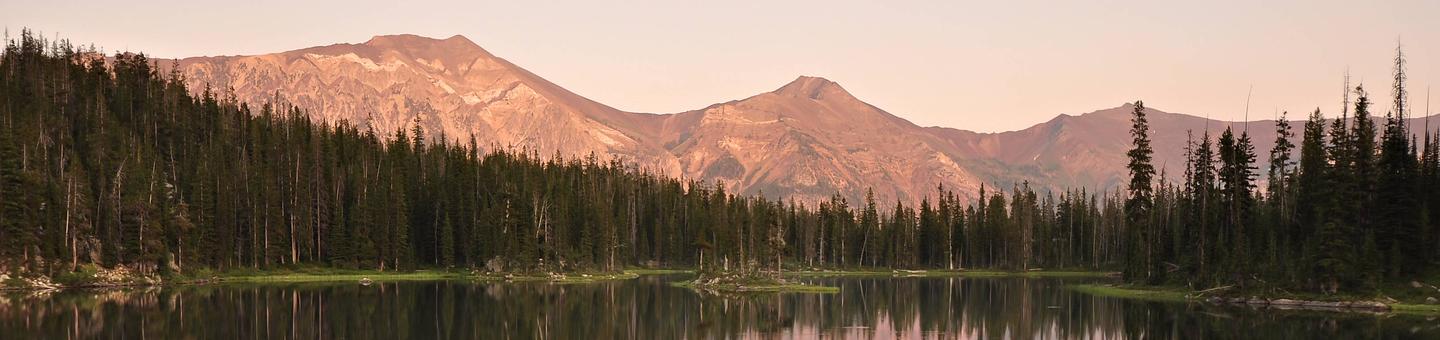
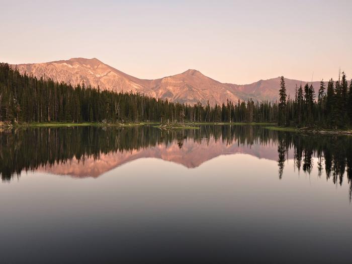
Eye Catching Scenery!
Spanning 2.3 million acres across the northeast corner of Oregon and western Idaho, the Wallowa-Whitman National Forest offers a variety of year-round recreational opportunities. With landscapes packed with rugged canyonlands, scenic vistas, and high mountain lakes, visitors have enjoyed the forest’s diverse landscape and recreational activities for generations.
Make the Wallowa-Whitman National Forest your ‘special place’ to visit this year!
Recreation Map
A map showing recreation areas.
Interactive Visitor Map Wallowa-Whitman National Forest
RecAreaDirections
Open with Google Map
Misc
| Stay Limit | |
| Reservable | false |
| Keywords | |
| Map Link | |
| Contact Phone | |
| Contact Email |
Permits info
Facilities
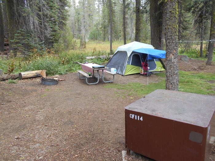
UNION CREEK CAMPGROUND Campground
List of CampsitesOverview
One of Eastern Oregon’s largest Forest Service campgrounds, Union Creek Campground is located 18 miles South of Baker City. Sitting along Phillips Reservoir’s North shore, Union Creek Campground boasts many amenities including over 60 tent/trailer sites, some with full hookups. There is access to boating, mountain biking, hiking and more.
This campground is part of the Union Creek Recreation Area, which includes a picnic and day-use area. Union Creek Campground is set on three loops with separate walk-in tent camping, and it has four group sites that can accommodate large groups up to 60 people.
PLEASE NOTE: This Union Creek Campground is located in northeastern Oregon in the Wallowa Whitman National Forest. This is not the Union Creek Campground located in southwestern Oregon near Medford.
Recreation
The campground is near a boat launch and a small, rocky swim beach. Activities include swimming, fishing, boating, and water skiing. Anglers can fish for bass, trout and perch. There's an access point for the Phillips Lake Shoreline Trail, a scenic trail for hiking and mountain biking. This trail can be connected to make a 16 mile loop around the lake.Facilities
The parking spurs are paved and gravel and large enough for any size RV. Several sites offer full hookups, and some others offer water and electric. Units are equipped with picnic tables and grills. Drinking water and flush toilets are available. Some of the facilities are handicap-accessible.Natural Features
Phillips Reservoir is a popular destination within the Wallowa-Whitman National Forest because it offers scenic views of the surrounding Elkhorn Mountains. The shoreline is forested with a mix of Ponderosa pine and various firs interspersed with small grasslands. Visitors enjoy several varieties of colorful wildflowers in the spring.Nearby Attractions
The historic gold mining town of Sumpter is about 10 miles away, West of Hwy 7. Visitors can explore the Sumpter Dredge State Heritage Park, browse the holiday weekend flea markets or take a ride on a historic steam locomotive.Charges & Cancellations
A $10.00 service fee will apply if you change or cancel your reservation. Late cancellations are subject to additional fees. For full details see NRRS Reservation PolicyAnthony Lake Campground
List of CampsitesOverview
At an elevation of 7,100 feet, this campground keeps cool in the summertime heat. The sites sit among boulders and mixed conifers on a bluff over Anthony Lake. For questions for Anthony Lake, Grande Ronde Lake, Mud Lake, Peavey Cabin, and Anthony Lake Guard Station call (541) 856-3277 ext. 114
None of the sites offer lake views, but campers can enjoy gazing on Gunsight Mountain and the surrounding peaks of the Elkhorn range.
Anthony Lakes Campgrounds Website
Recreation
There is a boat ramp available at the camp. Activities on Anthony Lake include boating, canoeing, kayaking and trout fishing.Trails in the area include the 22.6-mile Elkhorn Crest (foot and equestrian), 1-mile Black Lake (foot and equestrian) and the 1-mile Shoreline (foot).
Facilities
Each site has a paved parking apron, tent pad, picnic table and campfire ring with grill. Drinking water (Peak Season) and vault toilets are available.
Handicap-accessible sites are available.
Natural Features
The Wallowa-Whitman National Forest, 2.3 million acres of varied landscape, extends from the Blue Mountains and rugged Wallowa Mountains down to the spectacular canyon country of the Snake River on the Idaho border.Anthony Lake Campground is located in the Southern Elkhorn Mountain/Powder River Basin Area, with the highest peak in the Elkhorn Mountains at 9,108 feet. The area around the lake is known for conifer forests, wildflower meadows and the resident mountain goats.
Nearby Attractions
The Elkhorn Scenic Byway is a 106-mile drive through the Elkhorn Mountains. Along this drive are ghost towns and an abundance of lakes and rivers.Charges & Cancellations
A $10.00 service fee will apply if you change or cancel your reservation. Late cancellations are subject to additional fees. For full details see NRRS Reservation PolicyMUD LAKE CAMPGROUND Campground
List of CampsitesOverview
Mud Lake Campground is located across from the Anthony Lake Ski Area and near Mud Lake in the Wallowa-Whitman National Forest. Some campsites are tucked beneath dense pine and fir forest, while others sit in an open meadow. For questions for Anthony Lake, Grande Ronde Lake, Mud Lake, Peavey Cabin, and Anthony Lake Guard Station call (541) 856-3277 ext. 114
Recreation
Campers at Mud Lake have access to all the recreational activities at Anthony Lake, including boating, canoeing, kayaking and trout fishing. There is an accessible boat ramp available. Trails around Anthony Lake include the 22.6-mile Elkhorn Crest and the 1-mile Black Lake Trails for hiking and horseback riding, as well as the 1-mile Shoreline Trail for hiking only. Mud Lake is also near over 8 miles of singe track mountain bike trails and a downhill flow trail at the ski area.Facilities
Has 6 reservable standard electrical sites, and a standard non electric site are available. At an elevation of 7,100 feet, Mud Lake
Campground offers comfortable camping during the hottest part of the summer.
Each site has a picnic table and grill. Vault toilets are available at the campground, and drinking water is available at the Anthony Lake Campground, and Anthony Lake Day use area.
Natural Features
Mud Lake Campground is located in the Southern Elkhorn Mountain/Powder River Basin Area. Picturesque views of the ski area, Gunsight Peak and the Elkhorn Mountains are only a short hike across Forest Road 73, which is part of the Elkhorn Scenic Byway.Nearby Attractions
The Elkhorn Scenic Byway is a 106-mile drive through the Elkhorn Mountains. Along this drive are ghost towns and an abundance of lakes and rivers.Charges & Cancellations
A $10.00 service fee will apply if you change or cancel your reservation. Late cancellations are subject to additional fees. For full details see NRRS Reservation PolicyPEAVY CABIN Campground
List of CampsitesOverview
Peavy Cabin was built in 1934 by Dr. George Wilcox Peavy, Dean of the School of Forestry at Oregon Agricultural College (later Oregon State University). The facility was used as his outdoor laboratory to instruct forestry students.The cabin was then turned over to the Forest Service and used as a guard station. Several restoration projects have kept the integrity and charm of this historic structure, which is now recorded in the Heritage Resource Inventory as a historic site.
This cabin is available from July 1 until October 31 and is accessible via an unpaved road. High clearance and 4-wheel drive vehicles are recommended. Guests must bring some of their own supplies; however, Peavy Cabin does offers few modern conveniences to make for a comfortable stay.
Recreation
Peavy Trailhead is adjacent to the cabin and provides access to the North Fork John Day Wilderness via the Peavy Trail #1640 and the Cunningham Cove Trail #1643. Both trails connect with the Elkhorn Crest National Recreation Trail #1611. These trails are suitable for hikers and horseback riders.
The North Fork John Day River is a popular fishing spot for anglers wishing to catch smallmouth bass and steelhead.
For questions for Anthony Lake, Grande Ronde Lake, Mud Lake, Peavey Cabin, and Anthony Lake Guard Station call (541) 856-3277 ext. 114
Facilities
This rustic, single-room log cabin contains a fireplace with a wood stove for heating, a large table and benches, and enough beds to sleep 4. The kitchen is equipped with a gas range, refrigerator and dry sink, as well as some cooking and serving utensils.The grounds are partially fenced and include a picnic table and wood shed. Space is available for additional tent camping. A vault toilet is located near the cabin.
There is no potable water on-site, and guests must bring plenty for drinking, washing and cooking. Guests are expected to bring garbage bags to pack out trash and are required to clean the cabin before leaving.
Bedding, towels, dish soap and emergency items like flashlights and first aid kits are not provided. Phone service, fuel, and a small general store with a cafe are located approximately 15 miles away in the community of Granite.
Natural Features
The cabin sits next to the Wild and Scenic North Fork John Day River at an elevation of 5,900 feet. The Wild and Scenic North Fork John Day River originates in the North Fork John Day Wilderness, and the Baldy Unit section of this wilderness is adjacent to the cabin. The Baldy Unit features diverse landscapes like the rolling benchlands and the granite outcrops of the Greenhorn Mountains.Much of the wilderness is composed of gentle benchlands and tablelands; the remaining of steep ridges and alpine lake basins. Dense virgin stands of conifer species like Douglas fir, white fir, western larch and lodgepole pine cover the landscape. The area also supports wildlife species like Rocky Mountain elk, mule deer, RockyMountain goats and black bears (information on bear safety).
Nearby Attractions
Peavy Cabin is 3 miles from the state-designated Elkhorn Scenic Byway. This 106-mile drive through the Elkhorn Mountains passes through ghost towns and features numerous lakes and rivers.Charges & Cancellations
A $10.00 service fee will apply if you change or cancel your reservation. Late cancellations are subject to additional fees. For full details see NRRS Reservation PolicyANTLERS GUARD STATION CABIN Campground
List of CampsitesOverview
Antlers Guard Station was built in 1935 for the fire crews who patrolled Wallowa-Whitman National Forest. The Forest Roads were not yet well developed, and it was impractical for crews to travel daily between the remote parts of the forest and the ranger station. The Civilian Conservation Corps built this structure to allow crews to stay where they worked. Antlers Guard Station was listed on the National Register of Historic Places in 1991.Guests who stay at Antlers Guard Station can still get away from it all while enjoying the basic comforts of home. The cabin is accessible by car.
Recreation
This cabin is popular with rock hounds, botanists, hikers, mountain bikers, hunters, and ATV riders. Anglers can fish for trout in the North Fork Burnt River.Facilities
Antlers Guard Station is a cozy, rustic cabin with 2 small rooms. The combined living room and bedroom is furnished with a double futon and 2 sets of bunk beds that sleep 6 people comfortably. The kitchen has a table and chairs, a propane range and refrigerator, and utensils for cooking and eating.A propane fireplace for heating and propane lights are provided. An outhouse and garage are located near the cabin. Water is available from an outside hand pump, and there is a fire ring and picnic tables for outdoor dining.
Guests are required to bring garbage bags to pack out their trash, and they are expected to clean the guard station before leaving. Bedding, towels and emergency items like flashlights and first aid kits are not provided.
Natural Features
Antlers Guard Station sits at an elevation of 4,107 feet on the west bank of the scenic North Fork of the Burnt River. The surrounding forest is ponderosa pine.Rattlesnakes, mountain lions and black bears inhabit this area (information on bear safety).
Nearby Attractions
The town of Whitney is 2 miles from Antlers Guard Station. This ghost town, once the home of railway and sawmill workers, fell into decline around 1918. Several long-abandoned buildings are still standing.contact_info
For facility specific information, please call (541) 894-2332.Charges & Cancellations
A $10.00 service fee will apply if you change or cancel your reservation. Late cancellations are subject to additional fees. For full details see NRRS Reservation PolicyANTHONY LAKE GUARD STATION Campground
List of CampsitesOverview
Anthony Lake forms the source of Anthony Creek, named for William 'Doc' Anthony, an ambitious homesteader who came to Baker County in 1864. He was a farmer and a doctor, collected tolls on the Dealy Wagon Road for a time, and ran his ranch until he died in 1914 at age 85. Anthony Lake Guard Station is a historic Civilian
Conservation Corps log cabin built in the 1930s - one of only a few Forest Service cabins built of logs.
For questions for Anthony Lake, Grande Ronde Lake, Mud Lake, Peavey Cabin, and Anthony Lake Guard Station call (541) 856-3277 ext. 114
Guests at Anthony Lake Guard Station will find many modern comforts to help make their stay enjoyable. It's located at a popular recreation area and adjacent to the Anthony Lake Campground, and is easily accessible by car.
Recreation
A boat ramp is located on the lake. Activities include boating, canoeing and kayaking. Anglers can fly fish for trout. Trails in the area include the 22.6-mile Elkhorn Crest (foot and equestrian), 1-mile Black Lake (foot and equestrian) and the 1-mile Shoreline (foot).Facilities
This comfortable, rustic 2-story cabin features a kitchen, a full bathroom with a flush toilet and hot shower, one downstairs bedroom with a full size bed and a futon, two upstairs bedrooms with five twin beds, propane heater and electric lights.The kitchen is well-equipped with an electric stove and refrigerator, as well as cookware, eating utensils and place settings. Cleaning supplies are provided. A picnic table and campfire ring are just outside the cabin.
Guests are required to bring garbage bags to pack out trash, and they are expected to clean the cabin before leaving. Bedding and towels are not provided, and guests may also wish to bring emergency items, such as flashlights and a first aid kit.
Natural Features
The guard station is situated on the north shore of Anthony Lake, providing a stunning view of the lake and the glacial peaks of the nearby Elkhorn Mountains. The most prominent of these peaks is 8,342-foot Gunsight Mountain. This area is known for conifer forests, wildflower meadows and the resident mountain goats.The elevation is approximately 7,000 feet, and snow can be expected into July. Anthony Lake is sometimes frozen until mid-June.
Nearby Attractions
The Elkhorn Scenic Byway is a 106-mile drive through the Elkhorn Mountains. Along this drive are ghost towns and an abundance of lakes and rivers. Anthony Lakes Recreation is nearby with mountain bike trails and a seasonal restaurant.TWO COLOR GUARD STATION Campground
List of CampsitesOverview
The Civilian Conservation Corps originally constructed the Two Color Guard Station in the 1930s for use as crew quarters and bunkhouse. The original building was removed in 1976. The current guard station was built in 1959.Two Color Guard Station is open June through October. Guests can drive to it except after significant snowfall, when it's only accessible by snowmobile. Guests staying in the later part of the season are encouraged to bring extra supplies to ensure a comfortable and enjoyable stay.
Recreation
The cabin is near the Main Eagle Trailhead, which is southern portal into the Eagle Cap Wilderness (2 miles away). This trail is open to hikers and horseback riders.Forest Road 7755 is one of the designated roads on the snowmobile route south of the Eagle Cap Wilderness, and it can be used for snowmobiling, cross-country skiing and snowshoeing. Two Color Guard Station is the end of the groomed trail. Other open and closed forest roads are available for winter time exploring, but snowmobiles are prohibited within the Eagle Cap Wilderness.
Anglers can fish for rainbow trout in Eagle Creek, just 150 feet from the cabin's front door.
Facilities
The cabin is comfortably furnished with a table and chairs, couches, and enough beds to accommodate 12 people. Bedding and linens are not provided. Other amenities include propane lights, a propane cook stove and oven, refrigerator and heating stove. Cookware, place settings and most cooking utensils are provided.
Outside the cabin is a picnic table and a corral large enough for several stock animals. The outside vault toilet is accessible.
Water is not available, and guests must bring plenty for drinking, cooking and washing. Guests need to bring garbage bags for packing out trash, and the cabin must be cleaned before leaving.
Bedding, towels, dish soap and emergency items like flashlights and first aid kits are not provided. Click here for additional cabin details.
The price listed is per night with a maximum of 6 occupants. An additional fee of $20.00 per night is charged for occupants ranging from 7 to the maximum of 12 people. Fees are used directly for the maintenance and preservation of the guard station.
Natural Features
Outside the cabin, the crystal clear waters of the Wild and Scenic Eagle Creek work their way through the mountains to the valley floor in a series of small waterfalls and whitewater rapids. The landscape features subalpine firs and white bark pine as well as meadows that burst with colorful wildflowers. Guests will find blue-green pools and dramatic rock formations scattered along the creek's path.Two Color Guard Station is just a short distance away from the Eagle Cap Wilderness. This wilderness is characterized by high alpine lakes and meadows, bare granite peaks and ridges, and U-shaped glaciated valleys.
contact_info
For facility specific information, please call (541) 523-6391.Nearby Attractions
Within 10 miles there are opportunities for berry picking, hiking, horseback riding, mountain biking and hunting.Hells Canyon - Snake River (4 Rivers) Permit
Overview:
Hells Canyon, North America's deepest river gorge, encompasses a vast and remote region with dramatic changes in elevation, terrain, climate and vegetation. Carved by the great Snake River, Hells Canyon plunges more than a mile below Oregon's west rim, and 8,000 feet below the snow-capped He Devil Peak of Idaho's Seven Devils Mountains.The Snake River is designated a Wild and Scenic River. The 31.5-mile section of the river between Hells Canyon Dam and Upper Pittsburg Landing is designated Wild and the 36-mile section of river downstream from Upper Pittsburg Landing to mile 180.2 is designated Scenic.
Wild River reservations from Hells Canyon Dam to Upper Pittsburg Landing are required for the issuance of a trip permit seven days a week during the primary season, which is the Friday before Memorial Day through September 10. There are three private permit launches each day. These reservations can be obtained through the Four Rivers Lottery or by picking a cancellation once the lottery reservations have been allocated. Click here for a Floater Guide Summary with more information.
The application period for the Four Rivers Lottery is December 1 through January 31. Successful applicants must confirm their reservation no later than March 15. There is no wait list for unconfirmed reservations. Any remaining spots are released daily during a one-hour booking window. The booking window will open daily from 11 a.m. to noon Eastern Time. Click here for more information on the Four Rivers Lottery.
Self-issue river permits are required for the entire river corridor outside of the primary season, but do not require an advance reservation. They can be self-issued at any river portal.
Rafting and power-boating the rapids of Hells Canyon is not recommended for the inexperienced or poorly equipped. For floaters, portaging or lining through or around many of the rapids is difficult, if not impossible. For more information about the most challenging areas in Hells Canyon, as well as trip lengths, consult the National Wild & Scenic Rivers website.
Bear Creek Trailhead Facility
This trailhead provides access to Bear Creek Trail #1653, Washboard Trail #1680, Stanley Ridge Trail #1677, and Dobbin Creek Trail #1654 within Eagle Cap Wilderness.
Bear Creek runs along the entire trail, with many places to fish. The scenery is beautiful in this glacially formed drainage. The first three or four miles are open terrain. Views along the trail gradually change from flower filled meadows to scattered pines and a dense forest canopy.
The trail along Bear Creek is gentle with no major streams to cross. Campsites can be found at Boundary Campground which offers picnic tables, fire rings, and vault toilets, but no developed drinking water. Due to the open nature of the basin, there are many opportunities for dispersed camping along the trail. Historical sites may be observed along the way. You will ride or hike along mountain ridges, viewing spectacular scenery. This route transgresses into meadows, mountain peaks, forested scenery and rocky hillsides.
Water is available on trail #1653, but be prepared when traveling over trail #1680 to have your own drinking water. Horse users should be experienced if traveling over trail #1680.
View a printable information sheet on Bear Creek Trails 1653, 1680, 1677, and 1654 with map. (PDF File)
Bear Wallow Trailhead Facility
This is a gravel road and can be rough after the spring thaw. There is a loading ramp and hitch rails. A large number of hunters use this trailhead in the late summer and fall.
This site provides access to Standley Trail #1677, which enters Eagle Cap Wilderness. Standley Trail offers views of steep rocky mountain ranges framed by lush green valleys. The trail is very secluded as you travel along a forested ridge top. Most of the ridges are dry in the summer months so be sure to carry plenty of drinking water. The Standley Guard Station is an old cabin that was the site of range studies in the early 1900s. Sheep herds grazed in the area until recent years. The guard station cabin is in good condition, but is not for public use.
There are several trails that come together here, making this an excellent spot for a base camp. Connecting trails to the Minam River, North Minam River and Bear Creek can be accessed from the Standley Guard Station.
View a map of Standley Trail #1677 (PDF File)
Blue Springs Summit Sno-Park Facility
The Blue Spring Summit Sno-Park is a year-round facility situated off of the Elkhorn Drive Scenic Byway. This centrally located site is used both as a snowmobile trailhead in the winter months and as the northern OHV trailhead for the Blue Mountain OHV Trail in the late spring through fall months.
Cougar Ridge Trailhead Facility
The trail is well signed at the trailhead, boundary and all junctions. This site provides access to Cougar Ridge trail #1668 which enters Eagle Cap Wilderness.
Much of this trail is along the ridgetop, but will go in and out of old burned forested areas where you will see many ponderosa pine trees. The trailhead is equipped with a stock unloading ramp. This trail also offers excellent wildlife viewing opportunities.
There are many dispersed campsites along this route. The guard station cabin is in good condition, but is not for public use. There are several trails that come together near the cabin, making it an excellent choice for a base camp.
View a printable information sheet about this area and a map of the trail (PDF File)
Shady Campground Campground
List of CampsitesShady Campground is a small rustic campground located along the Wild and Scenic Lostine River. Nestled in a 'shady' cool fir and pine tree forest, the campground is popular during the summer for local and regional campers visiting the Lostine Canyon and Eagle Cap Wilderness. This campground is adjacent to the Maxwell Trailhead which climbs into the wilderness.
Wallowa Mtns/Eagle Cap Area Facility
The Wallowa Mountains/Eagle Cap Area is located in the center of the Wallowa Mountains west of Enterprise, east of LaGrande, Oregon, and north of Halfway, Oregon. This area includes developed recreation sites and trails for the Eagle Cap Wilderness, the Pine area of the Whitman Ranger District and the east side of the La Grande Ranger District.
Popular recreation areas include the Eagle Cap Wilderness, Lostine River Canyon, Hurricane Creek, Reds Horse Ranch, the Lakes Basin, Wallowa Lake Tram, Moss Springs, Catherine Creek, West and East Eagle, Fish Lake, Cornucopia, Clear Creek and 4 wild and scenic rivers: Lostine, Minam, Imnaha, Eagle Creek.
Local communities that have a variety of services (i.e. fuel, lodging, stores and/or restaurants) are Enterprise, Joseph, Lostine, Wallowa, LaGrande, Island City, Elgin, Cove, Halfway, Richland, Baker City. These communities are within one hour of this area.
Hells Canyon National Recreation Area - Idaho Facility
The Hells Canyon National Recreation Area (HCNRA) straddles both sides of the Snake River in Oregon and Idaho. This Hells Canyon National Recreation Area - Idaho section includes all developed recreation sites and trails that are all located away from the Wild and Scenic Snake River in the Idaho uplands. All other upland sites and all trails in the Hells Canyon NRA - Snake River, or Hells Canyon NRA - Oregon are found in those recreation area sections.
Popular recreation areas include the Hells Canyon Wilderness (Seven Devil mountain range), Black Lake, Heavens Gate Lookout, Windy Saddle, and Seven Devils recreation area.
Local Idaho communities that have a variety of services (i.e. fuel, lodging, stores and/or restaurants) are Riggins, Grangeville, Whitebird, Council, and Cambridge. These communities are within one hour of this area.
Hells Canyon - Oregon/Wallowa Valley Facility
The Hells Canyon National Recreation Area (HCNRA) straddles both sides of the Snake River in both Oregon and Idaho. The recreation sites and trails in this section are all found away from the Wild and Scenic Snake River in the Oregon uplands, and in other forest lands near the Wallowa Valley. All other upland sites and all trails in the Hells Canyon NRA - Snake River, or Hells Canyon NRA - Idaho are found in those recreation area sections.
Popular recreation areas include the Hells Canyon Wilderness (Oregon), Hat Point, Hells Canyon Overlook, Imnaha Wild and Scenic River and adjacent campgrounds, and Lord Flat.
Local Oregon communities that have a variety of services (i.e. fuel, lodging, stores and/or restaurants) are Enterprise, Joseph, Imnaha, Halfway, and Pine Creek. These communities are within one hour of the recreation area.
Blue Mtns North/Grande Ronde River Basin Area Facility
The Blue Mountain North/Grande Ronde River Basin Area is situated north of the Anthony Lakes Highway (Forest Road 73) to the Mount Emily area. It includes all of the developed recreation sites and trails in the northern Blue Mountains and those found in the Grande Ronde River Basin west of La Grande, Oregon. This area is mainly administered by the La Grande Ranger District although some of the area north of the Anthony Lakes Highway is administered by the Whitman Ranger District.
Popular recreation areas include the Oregon Trail Interpretive Park at Blue Mountain Crossing, Mt. Emily, Spring Creek Recreation Area, Ladd Canyon, and Beaver Creek.
Local communities that have a variety of services (i.e. fuel, lodging, stores and/or restaurants) are LaGrande, Island City, Elgin, Imbler, Cove, Richland, and Baker City. These communities are within one hour of this area.
Southern Elkhorn Mtn/Powder River Basin Area Facility
The Southern Elkhorn Mountain/Powder River Basin recreation area is located south of the Anthony Lakes Highway (Forest Road 73) to the Monument Rock Wilderness area. It includes all of the developed recreation sites and trails in the Blue and Elkhorn Mountains generally west of Baker City and Unity, Oregon.
Popular recreation areas include Anthony Lakes, Phillips Lake, North Fork John Day Wilderness (Baldy Unit), the Elkhorn Scenic Byway, the North Fork John Day River, the North Powder Wild and Scenic River, Dooley Mountain, Monument Rock Wilderness, the North and South Forks of Burnt River, the campgrounds along Highway 26, and Camp Creek. It also includes parts of the old Baker and Unity Ranger Districts that have been incorporated into the Whitman Ranger District.
Local communities that have a variety of services (i.e. fuel, lodging, stores and/or restaurants) are Baker City, Sumpter, Granite, Unity, Greenhorn and Haines. These communities are within one hour of the recreation area.
Kirkwood Ranch Facility
The Kirkwood Historic Ranch is an area rich in river history from early Native American occupation to pioneer ranching life. This very popular site is accessible by boat via the Snake River, or by hiking the Snake River National Recreation Trail which begins at Pittsburg Landing, approximately 6 miles down river. The historic ranch offers a taste of canyon life in the 1930s with the original ranch house, bunk houses and other out-buildings. As in the past, the cool green lawn and nearby stream offer summer time visitors a welcome rest.
Visitors are welcome to stop at the museum (Temporarily Closed) and learn about ranching life in the canyon. Displays in the log bunkhouse also contain prehistoric artifacts and interpret early Native American occupation in the canyon. A short 3/4 mile hike up Kirkwood Creek takes visitors to the Carter Mansion. It is a vertical log house built in 1920 by Dick Carter, a canyon resident who made his money manufacturing and selling moonshine during the Prohibition era.
Pittsburg Landing Boat Launch Facility
The Pittsburg Landing Boat Launch is adjacent to the Pittsburg Campground on the the Wild and Scenic Snake River in the Hells Canyon National Recreation Area. This large boating facility is open year-round and can accommodate large trailers with jetboats or rafts. The facility has accessible parking and toilets with paved roads however the ramp itself is not accessible. With access to the Snake River for fishing, boating, historic intepretation, and exploring and hiking, the facility is popular throughout the year. The Deer Creek road is maintained by the County as is steep and narrow for the last few miles after entering into the Hells Canyon National Recreation Area.
Dug Bar Trailhead and Boat Launch Facility
The Dug Bar Boat Launch and Trailhead is a multi-use year round recreation facility. It is the only driveable facility which accesses the northern end Snake River on the Oregon side in Hells Canyon and is popular with anglers, boaters, hikers, and other visitors. The boat launch has a small concrete ramp and accessible toilet.
The trailhead is primarily used for accessing the northern entrance of the Wild and Scenic Snake River and Hells Canyon Wilderness.
This site provides access to the Summit Ridge - Western Rim National Recreation Trail #1774 and Snake River Trail #1726. A public use back-country airstrip is adjacent to the facility, and an interpretive site for the the National Historic Nez Perce Trail #1727 is located near the historic river crossing.
Gumboot Creek Fish Interpretive Site Facility
The Gumboot Creek Fish Interpretive Site is a small roadside stop located along the Hells Canyon Scenic Byway. The interpretive panel describes the benefits of logs in Gumboot Creek for enhancing fisheries habitat.
Hells Canyon National Recreation Area
Indian Crossing Trailhead Facility
The Indian Crossing Trailhead is located at the 'end of the road' along the Wild and Scenic Imnaha River. This small trailhead allows visitors to explore the Hells Canyon National Recreation Area, Eagle Cap Wilderness and the Wild and Scenic Imnaha River from one location. Some stock facilities like loading ramps, hitching rails, and feed bunks are provide at the site. Located nearby is the Indian Crossing Campground.
Printable map and information about the South Fork Imnaha Trail #1816 to Trail #1820 (PDF File)
Cow Creek Trailhead Facility
The Cow Creek Trailhead is a small rustic trailhead along the Imnaha River. The site is primarily used in the spring for hikers, anglers and dual sport motorcycle riders going down to the Snake River, and summer and fall hunters. The road accessing this trailhead is rugged and not suitable for low clearance vehicles. 4-wheel drive recommended.
PO Saddle Trailhead Facility
The PO Saddle Trailhead provides access to the Summit Ridge - Western Rim National Recreation Trail #1774 and the southern end of the Hells Canyon Wilderness. The facility is a combination trailhead and horse camp with sites for tents or pull-through truck and trailer camping. A spectacular view of the canyon is found across the road.
Bird Track Interpretive Site Facility
The Bird Track Interpretive Site is located along the Grande Ronde River off Oregon Highway 244 directly across from the Bird Track Springs Campground. It is popular with birders, photographers, and those wanting to view wildlife and plants during the spring, summer, and fall, and with snowshoers in the winter. The recreation site has one main trail (#1940) which is 1.2 miles long and 5 other smaller spur trails with interpretive displays which wind along the river and cottonwood trees.
Buck Creek Forest Camp and Trailhead Facility
Located on the western side of the Eagle Cap Wilderness and very close to the wilderness boundary, the Buck Creek Campground/Trailhead was built to meet the needs of both wilderness trail users and overnight campers. After crossing the Buck Creek Bridge off the North Fork Catherine Creek Road, the narrow dirt road travels through isolated forest and towering rock cliffs to the combination campground and trailhead.
The area is also very popular for mushrooming in the Spring and berry picking in the Fall. In the late Summer and Fall, big game hunters use the site for day and extended overnight hunting trips.
Indian Rock Overlook Facility
The Indian Rock Overlook is situated at a viewpoint overlooks the beautiful Grande Ronde Valley. The overlook structure was built by the combined efforts of USDA Forest Service and Army National Guard 1249th Engineering Battalion personnel.
The Overlook is located near a major route traditionally used by Native Americans while transiting the Blue Mountains into the Grande Ronde Valley.
Awe aptly describes the feeling when considering the length of supply and mail wagon routes as well as herds of pig, cattle and sheep, which regularly traveled the length of the valley from the ranches, orchards and settlements once scattered about upon the valley floor.
Visitors will enjoy inspiring views of crop fields set in a patchwork quilt pattern. The fields below are growing bearing mint, wheat, barley, alfalfa, sugar beets, safflower, grapes, and lavender.
Across the valley towers the majestic Eagle Cap Wilderness. Let your imagination soar as you enjoy a picnic inside or outside of the shelter.
Moss Springs Campground Campground
List of CampsitesLocated above Cove, Oregon, the Moss Springs Campground lies on a ridgeline within view of the Eagle Cap Wilderness and is next to Moss Springs Trailhead. This popular campground was constructed to accommodate visitors with packstock, riding stock and campers bound for the wilderness. The site also has 3 accessible campsites and toilets. Trails from the campground drop steeply into the Minam River drainage or follow Grande Ronde Ridge.
Moss Springs Trailhead Facility
Moss Springs Trailhead is located near the Moss Springs Campground on the edge of the Eagle Cap Wilderness. provides access to Trail #1673, Trail #1919, Trail #1918, and Trail #1942.
The trailhead is popular with stock users as it offers a large stock vehicle parking area, loading ramp, feed bunks and holding facilities. Although the graveled forest road is a steep and narrow, many visitors enjoy the site to gain quick access to the Minam River Country.
From Moss Springs Trailhead you will travel through dense forested land, following the winding Little Minam and Minam Rivers. Dispersed camping sites are plentiful. You will find some good fishing spots along the way and observe the historic Horse Ranch along this route.
Printable information sheet and map about nearby trails (PDF File)
West Eagle Meadows Trailhead Facility
The West Eagle Meadows Trailhead is one of the 'late season' trailheads to open in the early summer due to the area's heavy snow accumulation and high elevation. Located near West Eagle Creek and meadow, this site is frequented by hikers and equestrians alike who want to enjoy a day or extended trip into the Eagle Cap Wilderness area. The combination trailhead and equestrian camp offers parking facilities for both stock and non-stock users, and has hitching rails, a loading ramp and feed bunks.
The West Eagle trail provides access to Echo, Traverse, Diamond and Tombstone lakes as well as a beautiful trip along the Minam River. You can also access many other destinations in the wilderness from this trail. Fishing and wildlife viewing opportunities abound as you travel through diverse landscapes of meadows, lakes, and mountains.
Adjacent to the trailhead is the West Eagle Meadows Campground with tent and walk-in campsites and a picnic area.
A printable map and additional information about the area.
Coyote Campground Campground
List of CampsitesCoyote Campground is situated in an open pine forest and grassland. The site offers 6 tent/trailer sites. Primary activities include; camping (summer and during fall hunting season) and picnicking.
Joseph Canyon Viewpoint Facility
The impressive view of Joseph Canyon can be seen from the Joseph Canyon Viewpoint. Located off of Highway 3, north of Enterprise, Oregon. The facility has interpretive signs of the canyon and the role it played as the winter home of the Chief Joseph Band of the Nez Perce tribe and their journey from the area in 1877.
As part of a series of Nez Perce Historic Trail sites, this facility is managed by the National Park Service.
Red Hill Lookout Viewpoint Facility
Located next to the fire lookout tower, the Red Hill Lookout Viewpoint offers spectacular views of the rolling forested mountains and distant Wallowa Valley. The site has minimal facilities.
Ah Hee Diggings Interpretive Site Facility
The Ah Hee Diggins Interpretive Site displays the mining efforts of Chinese miners in the late 1800s and the resulting hand-stacked rock tailings that can be seen from the Elkhorn Drive Scenic Byway. Although the miners could not file their own claims, holders could sell or lease worked-out claims to Chinese owned companies. To pursue their gold mining efforts, the miners muscled rock into piles across 16 acres of the valley to expose the streambed. They used gold pans, rockers and sluice boxes to extract the gold that was missed by previous mining operations from the sediment in the streambed.
Baker Valley Overlook Facility
The Baker Valley Overlook offers sweeping vistas of the Wallowa Mountains and Baker Valley. Located along the Elkhorn Drive Scenic Byway, this small overlook has intrepretive panels about the local agriculture, settlement and mining history of the area.
Baldy Creek Trailhead Facility
The Baldy Creek Trailhead is located on the north side of the Baldy Unit of the North Fork John Day Wilderness along the Elkhorn Drive Scenic Byway where Baldy Creek joins the Wild and Scenic North Fork John Day River. The site is frequented by summertime day hikers, backpackers, horseback riders and during fall hunting season. A primary attraction of the area is the hike into Baldy Lake.
The site provides access to Baldy Creek Trail # 1603 which lies almost entirely within the North Fork John Day Wilderness, providing access to the remote Baldy Creek drainage country, Baldy Lake, and the open ridges above the Cable Cove area. The trail follows and crosses Baldy Creek many times. It passes spruce, fir, and lodgepole pine forest; grassy openings: and some boggy areas. The old Cal-Pacific power line corridor, installed in the early 1900's is still visible, intersecting the trail about 5 miles from the lower trailhead.
Baldy Lake sits in a serene subalpine basin under Mt. Ireland. The fire lookout on top of the peak can be seen from the lake's north shore. One-quarter mile before Baldy Lake, a trail forks off across the head of the east fork of Baldy Creek up to the end of Forest Road 5540-920 just below Crown Point. For a sweeping view of the historic Cable Cove mining area, take a short walk up the old road which has no public vehicle access.
Baldy Lake Trailhead Facility
The Baldy Lake Trailhead is a small primitive trailhead that is located on the southwest edge of the North Fork John Day Wilderness and accesses the upper valley to Baldy Lake. It is most often used by day hikers, and fall hunters.
Bull Run Trailhead Facility
The Bull Run Trailhead is a very small minimally developed trailhead mostly used by Summer hikers and Fall hunters to access the southern Monument Rock Wilderness and Bull Run Ridge area. This site accesses Bullrun Trail #1961.
Clear Creek Trailhead Facility
The Clear Creek trailhead is a small rustic facility located on the southern side of the Wallowa Mountains. It is popular for hikers and stock riders going to the Clear Creek Reservoir and other backcountry areas.
Alert! Forest Service Road 030 only has a brown plastic road number signs but NOT a "Trailhead --->" directional sign from Forest Road 6610. The 030 road is a rough road suitable for high clearance vehicles. Passenger cars are not recommended. There are rocky sections and some areas of small streams and springs to cross.
Crawfish Basin Trailhead Facility
The Crawfish Basin Trailhead is a small rustic trailhead accessing Crawfish Basin Trail #1612 which enters the northern end of the North Fork John Day Wilderness.
Alert: The road to the site is steep and narrow. High clearance or 4x4 vehicles are recommended.
The Crawfish Basin Trail #1612 crosses the northeast portion of the North Fork John Day Wilderness and displays impressive views of Lakes Lookout, Lees Peak and Angel Peak. The trail also provides an excellent view of the ridges and draws extending to the southwest.
Traveling at 400 feet above Crawfish Meadow to the southwest, you can see the rock and spruce islands far below, as well as Crawfish Creek winding through the meadow. This meadow and a smaller, unnamed pond and meadow above the trail can be reached by short cross-country trips. At Dutch Flat Saddle the trail joins the scenic Elkhorn Crest Trail #1611.
Elkhorn Crest Trailhead Facility
The Elkhorn Crest Trailhead is a the northern main portal for the Elkhorn Crest National Recreation Trail. Located in the Anthony Lakes Recreation Area, this trailhead offers facilities for hikers, backpackers and stock users enjoying the trail for the day or multiple nights in the North Fork John Day Wilderness area.
Gold King Trailhead Facility
Gold King Trailhead is a small trailhead located in a picturesque meadow near East Eagle Creek. The site has a large gravel parking area for trucks and trailers and has picnic tables.
Visitors are asked to please respect private lands and roads in the area when using the trailhead or wilderness trails. Gold King Trail #1926 begins across the road northwest of the private land.
Marble Pass Trailhead Facility
The Marble Pass Trailhead is located on the southern end of the Elkhorn Crest National Recreation Trail in the Elkhorn Mountain range west of Baker City. The small site is very rustic with limited parking and difficult vehicle access.
Oregon OHV Trailhead Facility
The Oregon OHV Trailhead is located along Highway 7 adjacent to the Oregon Campground. The trailhead serves as a midway access area for the Blue Mountain OHV Trail. The recreation area has a parking area, loading ramp, and an accessible vault toilet.
Peavy Trailhead Facility
Peavy Trailhead is located along the North Fork John Day River near the North Fork John Day Wilderness area. The trailhead has a hitching rail for stock and provides access to Cunningham Cove Trail #1643 and the Peavy Trail #1640. Due to historic wildfires much of the area has large sections of burned timber with some regrowth.
Peavy Trail #1640 follows the North Fork John Day River drainage from the Peavy Cabin area to Columbia Hill, above the headwaters. The trail lies within the North Fork John Day Wilderness following an old roadbed through small grassy openings and burned stands of lodgepole pine and spruce that perished in the 1996 Sloan’s Ridge fire. After two miles, the trail climbs steeply crossing numerous small streams along the way. Just before the top, the trail contours along an open sagebrush hillside above a large meadow where campsites are available.
The Cunningham Cove Trail #1643 crosses the northeast section of the North Fork John Day Wilderness providing access to the Elkhorn Crest Trail from the North Fork John Day River area.
Although most of the trail is very steep and rough, it passes through several leveled clearings and meadows with secluded campsites and broad views of the rolling North Fork John Day country. Most of the length of the trail burned in the Sloan’s Ridge Fire in 1996.
The trail crosses Cunningham Creek several times and contours around a spring to join the Elkhorn Crest Trail (#1611) at Cunningham Saddle. From this point, a view into Crawfish Meadow and out towards Lees and Angell Peaks and Van Patten Butte unfolds.
Yellow Pine Campground Campground
List of CampsitesYellow Pine Campground is the largest of three Wallowa-Whitman campgrounds along Highway 26, which is part of the Journey Through Time Scenic Byway. The campground offers campsites for both tents and small trailers, and has five accessible campsites. Popular activities include; overnight camping for visitors traveling across the state, picnicking and exploring along the scenic byway. There is also an accessible, barrier-free, trail to Wetmore Campground. Wildflowers, wildlife, birds and large old growth ponderosa ("yellow") pine can be seen during the hike.
Eagle Cap Wilderness Facility
The Eagle Cap Wilderness lies in the heart of the Wallowa Mountains in northeastern Oregon on the Wallowa-Whitman National Forest. This country was first occupied by the ancestors of the Nez Perce Indian Tribe in 1400 A.D. and later the Cayuse, the Shoshone and Bannocks. The Eagle Cap Wilderness itself was used as hunting grounds for bighorn sheep and deer, to gather huckleberries and was the summer home to the Joseph Band of the Nez Perce tribe. 1860 marked the year the first settlers moved into the Wallowa Valley.
In 1930, the Eagle Cap was established as a primitive area. It was designated as wilderness in 1940. The Wilderness Act of 1964 placed the area in the National Wilderness Preservation System. It now totals 359, 991 acres.
The Eagle Cap Wilderness is characterized by high alpine lakes and meadows, bare granite peaks and ridges, and U-shaped glaciated valleys. One is constantly reminded that nature operates on her own terms with her own rhythms that may not match our structural lives. Each season comes and goes bringing with it new challenges and adventures.
We truly hope you will find these experiences here and carry with you a memory that will last a life time. These memories can only be left to future generations when we all take part in an effort to respect and care for wilderness. Doing your part is vital to the future of Eagle Cap.
Please plan your trip carefully, know the current regulations and follow minimum impact practices. Seek specific information from your nearest forest office.
- Key access points: Trailhead and trail information.
Monument Rock Wilderness: Wallowa-Whitman Facility
The Monument Rock Wilderness is located at the southernmost edge of the Blue Mountains and along the eastern edge of the Strawberry Mountain range. The area was established by Congress in 1984 as part of the Oregon Wilderness Act (P.L. 98-328).
Encompassing 20,079 acres this wilderness spans the Malheur and Wallowa-Whitman National Forests. Offering views across much of northeastern Oregon, elevations ranges from 5,200 feet in the lower slopes to 7,815 feet atop Table Rock. The northern end of the area lies across a watershed divide that separates the headwaters of the Little Malheur River and the upper drainage of the South Fork Burnt River.
The wilderness is mostly forested with ponderosa pine in lower hills stretching up to subalpine fir along the peaks. Other tree species include lodgepole pine, Douglas-fir, white fir, aspen, and juniper. Intermingled amongst the pine-fir forests and riparian stream bottoms are native grasslands with bluebunch wheatgrass, Idaho fescue and other indigenous grasses. Throughout the area is diversity of wildlife habitat for species such as mule deer, Rocky Mountain elk, badgers, and the rare wolverine. There are 70 species of birds living here, including the creek-loving American dipper and the pileated woodpecker. Soils in the area are predominantly volcanic ash, and rocks that are mostly lavas poured out over the land.
- Key access points: Trailhead and Trail information.
North Fork John Day Wilderness: Wallowa-Whitman Facility
The North Fork John Day Wilderness is comprised of four separate units - three on the Umatilla National Forest, and one on the Wallowa-Whitman National Forest. Located in the Elkhorn and Greenhorn Mountains, it totals 121,560 acres with 106,125 on the North Fork John Day District of the Umatilla National Forest and 14,435 on the Whitman District of the Wallowa-Whitman National Forest. During its establishment by Congress in 1984 as part of the Oregon Wilderness Act, the area was recognized for two main priorities. These were to increase protection of the headwaters tributaries of the North Fork John Day River, and protection of the remaining high quality anadromous fisheries habitat in the river basin.
The Baldy Unit is a smaller unit situated west of Baker City, Oregon and is managed by the Wallowa-Whitman National Forest. It has several scenic subalpine lake basins characteristic of the area, and the headwaters of the North Fork John Day River, Bull Creek, Baldy Creek, and Crawfish Creek. From rolling benchlands to the granite outcrops of the Greenhorn Mountains, the rugged Baldy Unit provides diverse landscapes. Much of the wilderness is composed of gentle benchlands and tablelands; the remaining of steep ridges and alpine lake basins. A continuous vegetative canopy covers most of the land, including dense virgin stands of conifer species like Douglas-fir, white fir, western larch and lodgepole pine.
- Key access points: Trailhead and Trail information.
Hells Canyon Wilderness Facility
The Hells Canyon Wilderness is composed of 217,927 acres of high mountain peaks, ominous canyon rim-rocks, breathtaking vistas, and quieting solitude.
Established in 1975 as part of the Hells Canyon National Recreation Act (P.L. 94-199) the wilderness is split by the Snake River into two distinct areas – one in Oregon and the smaller portion in Idaho. Although the Wallowa-Whitman National Forest has the lead stewardship responsibility, the wilderness also includes lands from the Payette National Forest, Nez Perce National Forest, and Bureau of Land Management.
At lower elevations on the Idaho side, dry, barren, steep slopes break over into the Snake River canyon. In the high country are the towering peaks, rock-faced slopes, and alpine lakes of the Seven Devils Mountain Range - said to be named for a vision of seven dancing devils that appeared to an Indian lost in the area. The legend fits. Here, splendid mountain peaks rise well over 9,000 feet, and bear names like She Devil, He Devil, Ogre, Goblin, Devil's Throne, Mt. Belial and Twin Imps.
On both the Oregon and Idaho sides the higher elevation areas are characteristic of rocky slopes and grasslands laced with 'stringer canyons' and groves composed of Douglas fir and ponderosa pine. The lower elevations are dominated by grassland benches with steep canyons and ravines dissecting the isolated Oregon-side. Species of interest are Rocky Mountain elk, Rocky Mountain bighorn sheep, mule deer, and chukar.
- Key access points: Trailhead and Trail information.
Hells Canyon - Snake River (Powerboat) Permit
Overview:
Hells Canyon, North America's deepest river gorge, encompasses a vast and remote region with dramatic changes in elevation, terrain, climate and vegetation. Carved by the great Snake River, Hells Canyon plunges more than a mile below Oregon's west rim, and 8,000 feet below the snow-capped He Devil Peak of Idaho's Seven Devils Mountains.The Snake River is designated a Wild and Scenic River. The 31.5-mile section of the river between Hells Canyon Dam and Upper Pittsburg Landing is designated Wild and the 36-mile section of river downstream from Upper Pittsburg Landing to mile 180.2 is designated Scenic.
Although uncommon on most wild and scenic rivers, powerboats have been used on the Snake River in Hells Canyon National Recreation Area for many years and Congress included specific language in the Hells Canyon National Recreation Area Act which allows their continued use.
Reservations are required during the primary season, which is the Friday before Memorial Day through September 10, 7 days a week in the Wild section and Fridays, Saturdays, Sundays and Holidays in the Scenic section. The system will be available for current year reservations March 1, annually.
Wild River reservations are required for all powerboat trips between Hells Canyon Dam and Upper Pittsburg Landing during the Primary Season. Six wild river launches are available for each day. A wild river permit also allows use of the scenic river. Non-Motorized periods in the wild river have additional restrictions.
Scenic river permits are required on Fridays, Saturdays, Sundays and Holidays from Cache Creek Administrative Site at the Oregon-Washington State Line to upper Pittsburg Landing during the primary season unless you have a wild river launch reservation which also allows use of the scenic river. Twenty-three scenic launches are available for each day; five of the 23 are for Lower Salmon River access and are day-use only.
The 1994 Wild and Scenic Snake River Recreation Management Plan (revised in 1999. Click here to view) established a non-motorized period. The objective of the period was to provide for extended periods of remoteness by limiting encounters with motorized users in the wild river section. The non-motorized section of the wild river is from Kirkwood Historic Ranch to Wild Sheep Rapids. Powerboat access will not be authorized during those times in that section of the wild river. Click Here to see the current year's non-motorized calendar.
Self-issue river permits are required for the entire river corridor outside of the primary season, but do not require an advance reservation. They can be self-issued at any river portal.
Rafting and power-boating the rapids of Hells Canyon is not recommended for the inexperienced or poorly equipped. For more information about the most challenging areas in Hells Canyon, as well as trip lengths, consult the Wild and Scenic Snake River Boaters Guide
Little Kettle Creek Trailhead Facility
The Little Kettle Creek Trailhead is located along East Eagle Creek on the southern end of the Wallowa Mountains. This trailhead is popular in the summer for day and extended trips into the southern Wallowa Mountains and Eagle Cap Wilderness, and in the fall for big game hunting. Visitors have two options for accessing trails in this area. They can park at this Little Kettle Creek Trailhead which has truck and trailer parking, a vault toilet and stock facilties and accesses the Kettle Creek Trail #1945, or at the end of Forest Service road 7745 at the East Eagle Trailhead with primary access to the East Eagle Creek Trail #1910.
Saddle Creek Campground Campground
List of CampsitesSaddle Creek Campground is a smaller site located on the rim of Hells Canyon along the Hat Point Road. With 7 walk-in tent-only sites, visitors can enjoy a remote campout or just picnic and look across Hells Canyon at the Seven Devils Mountains in Idaho. The area was heavily burned with wildfires in the past so shade and mature trees are scarce near the campground.
Hells Canyon National Recreation Area
Frog Pond Trailhead Facility
Frog Pond Trailhead is located at the northern end of the Hells Canyon National Recreation Area.
Tenderfoot Trailhead Facility
Tenderfoot Trailhead is a rustic trailhead located next to the eastern side of the Eagle Cap Wilderness area. The facility is set in an open pine area and accesses the Tenderfoot Wagon Trail #1819. The large parking area will accommodate several trucks and trailers.
Please see this March 26, 2015 article in The Oregonian for more information.
