
Apache-Sitgreaves National Forest

Its called God's Country . . . lakes and mountains. The Mogollon Rim made famous by Zane Grey. The White Mountains made green by ponderosa pine, gentled by cold waters flowing to the valleys below and far beyond. It is a physically challenging and rewarding recreational landscape. A place of spiritual renewal and more . . .
Enjoy your National Forests but please remember: FIREWORKS are not allowed on the National Forest.
When camping or picnicking, please keep your site clean; free from trash and food. Otherwise animals and insects are attracted to your site.
Please practice Leave No Trace ethics... Bag your trash and take it home with you. Help us keep our forests clean and green by "Packing It Out!"
Feel free to have a campfire but ALWAYS be in attendance of your fire; when you leave, PUT IT OUT- COLD OUT! Put lots of water on it (about 5 gallons), mix and stir dirt in, then do it again until you can put your bare hand on the coals and they are cool to the touch! Putting your fire out can take awhile. Please start extinguishing it BEFORE you start packing up.
Human Waste is a big problem when thousands of people converge on the Forest. Please see Leave No Trace - Dispose of Waste Properly for detailed instructions on handling this "delicate" situation.
Sharing the trail with horses:
Here’s a great resource on sharing trails with horses, mountain bikers, and hikers: “What a Horse Sees!” – a short film illustrating safe ways of passing horse and rider on the trail. Trailmeister.com
With your help, we can protect our natural resources for future generations.
Thank you!
RecAreaDirections
Open with Google Map
Misc
| Stay Limit | |
| Reservable | false |
| Keywords | |
| Map Link | |
| Contact Phone | |
| Contact Email |
Permits info
Important Information
Hikers must take IGBC approved bear resistant food storage containers in this area. Free loan out of these containers is available at Grand Teton permit stations with a valid backcountry permit.
Facilities
GENTRY GROUP CAMPGROUND Campground
List of CampsitesOverview
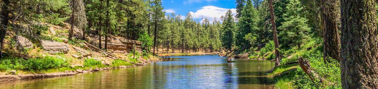
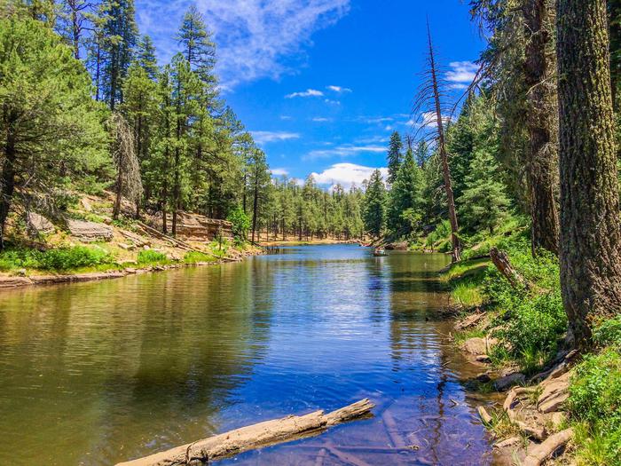
Gentry Group Campground is positioned on a ridge that divides two canyons. From the campground visitors enjoy views of Black Canyon Lake and the forested hillsides and canyons beyond. Due to limited maneuvering space, this campground is recommended for tents or small campers only.
Recreation
Recreation opportunities in the area include hiking, photography and wildlife viewing. Visitors can often see a herd of wild horses which frequent the area.
Facilities
Gentry Group Campground offers picnic tables, campfire grills, and a vault toilet. Roads are sand and gravel. There is a campground host available at the Black Canyon Rim campground.
Natural Features
The area is relatively flat with sandy surfaces. The campground is sheltered among towering ponderosa pines interspersed with fir and oak.
contact_info
For facility specific information, please call (928) 535-0181.Nearby Attractions
Gas, phone and groceries are available adjacent to Highway 260, approximately 10 miles west at Forest Lakes or 13 miles east at Heber.
LUNA LAKE Campground
List of CampsitesOverview
Luna Lake Campground is a pleasant vacation site with open forest, lush meadows, a lake with great fishing, first rate mountain scenery and additional recreation facilities located within easy travel distance. This friendly campground is located in an open stand of ponderosa pines within walking distance of Luna Lake and 5 miles east of the town of Alpine, Arizona, close to the New Mexico border.Recreation
Fishing, horseback riding, boating, mountain biking and hiking are some of the activities enjoyed by campers. A non-motorized trail system is open to horse, bicycle and pedestrian travel. Visitors should be aware that although horses are allowed on some of the trails, livestock is not permitted in the campground.Fishing is available in the lake, and a boat ramp provides easy access to the water. The lake is stocked with rainbow trout. The lake is used for irrigation during the summer; fishing is best in spring and early summer. A marina, fishing pier, bait shop, boat rentals and picnic area are located in the day use area.
Families can also learn about the many cultural and natural features of the forest by attending educational programs in July and August.
Facilities
The rustic campground is located a short distance from Luna Lake. Three group campsites are available for reservation, including two double sites and one large group site that can accommodate up to 120. Vault toilets and drinking water are provided.Natural Features
The area sits at an elevation of 8,000 feet in the scenic Apache National Forest in eastern Arizona. The campground is near 75-acre Luna Lake, surrounded by a ponderosa pine forest. A large wetland for nesting waterfowl lines the lakeshore, providing good wildlife viewing opportunities.Nearby Attractions
The town of Alpine is convenient for shopping and services. The area is also rich with cultural history, outdoor recreation and sightseeing opportunities, including the Coronado Trail Scenic Byway and Escudilla Wilderness.Visitors can explore endless vistas and take part in many outdoor activities in the surrounding Apache-Sitgreaves National Forest, which encompasses 2 million acres of magnificent mountain country in east-central Arizona and New Mexico.
LEWIS CANYON Campground
List of CampsitesOverview
Lewis Canyon is a large single-group campsite located in the scenic White Mountains region of eastern Arizona. With several amenities and activities, including hiking and horseshoes, the facility is great for family gatherings and other large groups.
Recreation
A variety of recreation opportunities are available from the campground, including hiking, a horseshoe pit, a baseball field and access to the beautiful and extensive White Mountain Trail System for hiking and mountain biking. Numerous Forest Service Roads nearby can accomodate OHV enthusiasts on a variety of terrain.
Facilities
Lewis Canyon can accommodate up to 150 guests. The camping area is secluded, and is spaced around a large loop for the group to spread out. Vault toilets and a picnic area are provided.
Natural Features
Lewis Canyon Campground is located in a beautiful ponderosa pine setting with a large open field nearby. It sits at an elevation of approximately 6,600 feet in the Sitgreaves National Forest. Wildlife including turkey, elk and mule deer are often seen nearby.
Summer temperatures can be very pleasant because of the elevation. However, the summer monsoon season often brings afternoon thunderstorms from late June through August. Visitors should come prepared for rain and cool nighttime temperatures.
Nearby Attractions
Visitors can explore vistas and take part in many outdoor activities in the surrounding Apache-Sitgreaves National Forest, which encompasses 2 million acres of magnificent mountain country in east-central Arizona and New Mexico.
ASPEN (AZ) Campground
List of CampsitesOverview
Aspen Campground is a scenic hideaway for anglers, boaters, families and photographers, located in north central Arizona near Heber and Payson. It sits in a dense pine and aspen area forest near the shore of Woods Canyon Lake at an elevation of 7,000 ft. With spacious campsites, calm and scenic lake waters, a marina, boat ramp and many amenities, Aspen is one of the most popular camping spots in Arizona.Recreation
Popular activities include trout fishing, hiking, boating and photography. Woods Canyon Lake is one of seven lakes in the Rim Lakes Recreation Area, and one of the most visited. Two other lakes are within a short drive. Woods Canyon Lake only allows electric boat motors.An easy hiking trail meanders around the lake, and the campground's paved roads make for great bike rides. Families might also enjoy attending educational programs given by Forest Service rangers on the weekends.
Facilities
Aspen Campground is a large facility with 148 campsites. It is composed of four loops in alternating meadow and wooded areas, and campsites are spaced well apart from each other.The nearest showers are 10 miles away at Canyon Point Campground.
A marina with a full service store with groceries, boat rentals and firewood is available at the lake. Gas, phone and groceries are also available in nearby Forest Lakes.
Natural Features
The large and rambling campground offers several camping experiences and environments from marshy meadows to a rocky forest. Wildlife viewing includes birds, squirrels, deer and elk. Deer, skunks and bears are common campground visitors.Summer temperatures can be very pleasant because of the elevation. However, the rainy season often brings afternoon thunderstorms from late June through August. Visitors should come prepared for rain and cool nighttime temperatures.
Nearby Attractions
Visitors can explore endless vistas and take part in many outdoor activities in the surrounding Apache-Sitgreaves National Forest, which encompasses 2 million acres of magnificent mountain country in east-central Arizona and New Mexico. The Mogollon Rim Visitor Center, open weekends from Memorial Day through Labor Day, is only a short drive from Aspen Campground. Visitors can find an informative staff as well as books and gifts related to the local area. The nearest towns are Heber and Payson.contact_info
For facility specific information, please call (928) 535-0181.BENNY CREEK GROUP AREA Campground
List of CampsitesOverview
Benny Creek Campground offers group camping in the remote and scenic White Mountains of Arizona. A perfect outdoor retreat for small to medium group gatherings, the campground is situated in a pine forest above Benny Creek and within walking distance of Bunch Reservoir and Greer Lakes. Picnicking, fishing, hiking and boating are often enjoyed by campers.Recreation
Excellent creek and lake fishing for trout draws anglers to the campground. Hikers can seek out the Squirrel Springs trail nearby.Those wishing to relax on a scenic drive can explore the White Mountain and Coronado Trail Scenic Byways.
Facilities
Three group camping areas are available for groups up to 24 or 32 guests. When not reserved, these sites may be available on a walk-in basis, and there are several individual sites that are also first-come, first-served.The campground can accommodate tents, trailers and small motorhomes up to 24 feet. A dump station is available across the highway at Hoyer Campground.
Natural Features
Benny Creek Campground sits in the White Mountains of eastern Arizona at an elevation of 8,250 feet. Campsites are fairly open under a canopy of ponderosa pine. Abert squirrels and chipmunks are common campground residents, and mule deer and elk inhabit the area as well. The nearby reservoir is one of three area lakes on the Little Colorado River.Summer temperatures can be very pleasant due to the elevation. However, the rainy season often brings afternoon thunderstorms from late June through August. Visitors should come prepared for rain and cool nighttime temperatures.
Nearby Attractions
The nearby town of Greer offers gas, groceries, restaurants and equipment rentals.Visitors can explore endless vistas and take part in many outdoor activities in the surrounding Apache-Sitgreaves National Forest, which encompasses 2 million acres of magnificent mountain country in east-central Arizona and New Mexico.
BROOKCHAR Campground
List of CampsitesOverview
Brookchar Campground is tucked on the banks of Big Lake in the White Mountains of eastern Arizona. The campground is a small, tent-only facility comprised entirely of walk-in sites. Of the lake's five campgrounds, Brookchar is nearest to the water. The stocked lake draws anglers, and boat rentals and a boat ramp make it easy for campers to enjoy the lake's blue waters.Recreation
Big Lake is one of Arizona's top trout fishing lakes, with rainbow, cutthroat, brook and Apache trout being the most sought-after species. The recreation area is also popular for hiking, mountain biking, horseback riding, birding and wildlife viewing.Facilities
The facility is small, with 12 tent-only, walk-to campsites. Campfire rings and restrooms are provided. A campground host resides on-site for visitor assistance.A dump station, store, firewood, gas, food and boat rentals are located a short, half-mile drive away, and showers are just 1 mile away.
Natural Features
The campground sits in the Apache-Sitgreaves National Forest at an elevation of 9,100 feet. The area is scenic, forested with ponderosa pine, fir, spruce and aspen, interspersed with high elevation meadows.Summer temperatures are pleasant and cool, a nice respite from the heat of lower deserts. Visitors should come prepared for afternoon thunderstorms and cool nighttime temperatures.
Nearby Attractions
Several other lakes can be found in the surrounding area. Visitors can also explore endless vistas and take part in many outdoor activities in the surrounding Apache-Sitgreaves National Forest, which encompasses 2 million acres of magnificent mountain country in east-central Arizona and New Mexico.CANYON POINT Campground
List of CampsitesOverview
Located in the scenic Apache-Sitgreaves National Forest in north central Arizona near the town of Heber, Canyon Point has a range of individual and group campsites to suit many visitors.The campground sits in a heavily wooded pine and aspen area 5 miles from the popular Willow Springs Lake. Campers enjoy trout fishing (both lake and stream), hiking, boating and photography.
Recreation
Hikers enjoy staying at Canyon Point because of its access to trails to the Sinkhole and the edge of the Mogollon Rim, which offers a spectacular view.Its proximity to Willow Springs Lake also draws boaters and anglers. Families who stay on the weekends often attend educational programs given by Forest Service rangers at the facility's amphitheater.
Facilities
Canyon Point has 113 campsites, 32 of which have electricity. Tents, trailers and motor homes up to 75 ft. are allowed at the campground. Three of the single unit sites are accessible.Larger families can be accommodated at the five double sites which can hold up to 16 people each, and there are two group sites that can host up to 25 or 55 people, respectively. Each site has a picnic table and campfire ring with grill.
Showers and restrooms are provided, and firewood is available for sale.
Natural Features
Canyon Point lies in a forested area above the Mogollon Rim at an elevation of 7,500 ft. The Mogollon Rim, pronounced by locals as "muggy-own," is a 200-mile long escarpment in northern Arizona that ranges between 5,000 and 7,000 ft in elevation. The unique landscape was created by the uplift of the Colorado Plateau followed by erosion and faulting that has sculpted spectacular canyons and buttes. The rim serves as the geographical divide between the cool high country above and the hot, dry desert below. Summer daytime temperatures are generally 20 - 40 degrees cooler than the greater Phoenix Area. However, the rainy season often brings afternoon thunderstorms from late June through August. Visitors should come prepared for possible rain and cool nighttime temperatures.contact_info
For facility specific information, please call (928) 535-0181.Nearby Attractions
Forest Lakes, Arizona is located approximately 2 miles east of the campground. Visitors can find food, fuel, telephones, and groceries. The nearest full service community is Overgaard, 22 miles east on Highway 260.CUTTHROAT Campground
List of CampsitesOverview
Cutthroat Campground lies at an elevation of 9,000 feet in the White Mountains of eastern Arizona. It sits on the shoreline of Big Lake and affords visitors many recreational opportunities in a quiet, scenic setting. Popular activities include trout fishing and hiking.Recreation
Named after a species of trout, Cutthroat is adjacent to 450-acre Big Lake, one of Arizona's top fishing lakes. The lake is known for its trout fishing, with rainbow, cutthroat, brook and Apache being the most sought-after species. The recreation area is also popular for hiking, mountain biking, birding and wildlife viewing.Facilities
Sites for tent camping only are scattered throughout this small facility and spaced a good distance apart. Some are directly on the waterfront. The basic amenities of restrooms, picnic tables and drinking water are provided, and anglers and boaters have the convenience of a boat ramp. An RV dump station is one mile away.Natural Features
The campground is located in a very scenic area, forested with ponderosa pine, spruce, Douglas fir, and aspen trees, which provide ample shade. Summer temperatures are pleasant and cool, a nice respite from the heat of lower deserts. Visitors should come prepared for cool nighttime temperatures and occasional summer rain storms.Nearby Attractions
Visitors can explore endless vistas and take part in many outdoor activities in the surrounding Apache-Sitgreaves National Forest, which encompasses 2 million acres of magnificent mountain country in east-central Arizona and New Mexico.GRAYLING Campground
List of CampsitesOverview
Grayling Campground offers perhaps the most secluded sites in the Big Lake Recreation Area in eastern Arizona. It sits on the shoreline of the lake in a mixed conifer and aspen forest and affords visitors many recreational opportunities in a quiet, scenic setting. Popular activities include trout fishing and hiking.Recreation
The campground is adjacent to 450-acre Big Lake, one of Arizona's top fishing lakes. The lake is known for its trout fishing, with rainbow, cutthroat, brook and Apache being the most sought-after species.The recreation area is also popular for hiking, mountain biking, birding and wildlife viewing. Curious campers can attend educational programs at the recreation area's visitor center.
Facilities
All 23 campsites in this small facility are located along one loop. Some sites have a view of the lake, though none are directly on the waterfront. Flush toilets are a comfort of home, and showers can be found one mile away.A dump station for RV campers is one mile away. A store is also nearby with gas, food, boat rentals and firewood for sale.
Natural Features
Grayling sits in the White Mountains at an elevation of 9,000 feet. It is a very scenic area, forested with ponderosa pine, Douglas fir, spruce and aspen trees, which provide ample shade. Summer temperatures are pleasant and cool, a nice respite from the heat of lower deserts. Visitors should come prepared for cool nighttime temperatures and occasional summer rain storms.Nearby Attractions
Visitors can explore endless vistas and take part in many outdoor activities in the surrounding Apache-Sitgreaves National Forest, which encompasses 2 million acres of magnificent mountain country in east-central Arizona and New Mexico. Springerville, Arizona is the closest town to the campground.HOYER Campground
List of CampsitesOverview
Hoyer Campground is situated among the ponderosa pine forests of eastern Arizona, and is one of the most popular campgrounds in the area for families and seniors. Is is less than a mile from Greer Lakes in the middle of the Apache National Forest. Hiking and fishing are especially popular.Recreation
Greer Lakes and the Little Colorado River are within walking distance for avid anglers seeking out rainbow, cutthroat, brook and brown trout. Hikers can check out several trails within a short drive. Those wishing to relax on a scenic drive can explore the White Mountain and Coronado Trail Scenic Byways.Curious campers can take part in guided nature walks around the lake or attend educational programs at the facility's amphitheater on Saturday evenings during the summer.
Facilities
This large facility contains nearly 100 campsites. Sites are shaded and lie on a bed of pine needles or grass. Roads are gravel.
The shower facilities and dump station are open. Campers can also purchase bundled firewood and ice from the on-site campground host.
Natural Features
The campground sits in a heavily forested pine and aspen forest at an elevation of 8,300 feet in the scenic and remote White Mountains. Chipmunks and Abert's squirrels are common campground residents, and mule deer and elk inhabit the area as well. The nearby reservoir is one of three area lakes on the Little Colorado River.Summer temperatures can be very pleasant because of the elevation. However, the rainy season often brings afternoon thunderstorms from late June through August. Visitors should come prepared for rain and cool nighttime temperatures.
Nearby Attractions
The closest towns are Greer and Springerville, Arizona. Campers can find gas, groceries, restaurants and equipment rentals in Greer.Visitors can explore endless vistas and take part in many outdoor activities in the surrounding Apache-Sitgreaves National Forest, which encompasses 2 million acres of magnificent mountain country in east-central Arizona and New Mexico.
RAINBOW (AZ) Campground
List of CampsitesOverview
Rainbow is the largest campground in the Big Lake Recreation Area in eastern Arizona. Because of its proximity to the lake, size and the many amenities it offers, Rainbow is a favorite for families. Popular activities include hiking, horseback riding and fishing.Recreation
The campground is adjacent to 450-acre Big Lake, one of Arizona's top fishing lakes. The lake is known for its trout fishing, with rainbow, cutthroat, brook and Apache being the most sought-after species.The recreation area is also popular for hiking, mountain biking, birding and wildlife viewing. Curious campers can attend educational programs at the recreation area's visitor center.
Facilities
The facility boasts 165 campsites organized into six loops. Four double sites are available for up to 16 people each, which is convenient for larger families, and two single unit accessible sites are also available.A small store nearby sells gas, food, boat rentals and firewood. A campground host is available on-site for visitor assistance.
Natural Features
Rainbow Campground sits at an elevation of 9,000 feet in the White Mountains. It is a very scenic area, forested with ponderosa pine, Douglas fir, spruce and aspen trees, which provide ample shade.Summer temperatures are pleasant and cool, a nice respite from the heat of the lower desert. Visitors should come prepared for cool nighttime temperatures and occasional summer thunderstorms.
Nearby Attractions
Visitors can explore endless vistas and take part in many outdoor activities in the surrounding Apache-Sitgreaves National Forest, which encompasses 2 million acres of magnificent mountain country in east-central Arizona and New Mexico. Springerville, Arizona is the closest town to the campground.SPILLWAY (AZ) Campground
List of CampsitesOverview
Spillway Campground is on the shores of popular Woods Canyon Lake near the town of Heber in north central Arizona. Situated in a pine forest with plenty of shade, the campground has individual campsites as well as one group campsite for small gatherings. Given its proximity to the lake, hiking trails and scenic areas, Spillway is a convenient getaway for anglers, boaters, hikers, families and photographers.Recreation
Woods Canyon Lake is one of seven lakes in the Rim Lakes Recreation Area, and one of the most visited. Trout fishing (both lake and stream) is a favorite pastime. Woods Canyon Lake only allows electric boat motors. Two other lakes are within a short drive.The Rim Lakes Vista Trail, less than a mile from the campground, and others in the area lead to spectacular views of the Mogollon Rim. An easy hiking trail meanders around the lake, and the paved roads in the recreation area make for great afternoon bike rides.
Families might also enjoy attending educational programs given by Forest Service rangers on the weekends.
Facilities
The campground is a relatively small facility with 26 individual campsites and one group site that can accommodate up to 25 people. Tents, trailers and small motorhomes are allowed - please read information on each individual spur size to determine if your RV will fit in the site. The main campground loop road has a fairly tight turning radius hedged by trees so no RV/trailer over 32' is recommended. Each shaded campsite offers a leveled spur, picnic table, fire ring, and charcoal grill. All campsites, loop road, vault restrooms, and water hydrants are compliant with the Architectural Barriers Act for accessibility. Some sites are directly on the lakeshore with a view of the water.
Restrooms are provided. Boat rentals and basic camping supplies are available at the Woods Canyon Store, while the nearest showers are at Canyon Point Campground 10 miles away.
Natural Features
Spillway is located in a thick forest of ponderosa pine, oak and Douglas fir at an elevation of 7,500 ft. The campground is situated on the lakeshore overlooking the calm blue waters of 52-acre Woods Canyon Lake, where visitors may see squirrels, deer, elk and a variety of birds.Nearby hiking trails offer views of the Mogollon Rim, a 200-mile long cliff in northern Arizona that ranges between 5,000 and 7,000 feet in elevation and serves as the geographical dividing line between the cool high country above and the hot, dry desert below.
Summer temperatures can be very pleasant because of the elevation. However, the rainy season often brings afternoon thunderstorms from late June through August. Visitors should come prepared for rain and cool nighttime temperatures.
contact_info
For facility specific information, please call (928) 535-0181.Nearby Attractions
Gas, phone and groceries are available 10 miles east at Forest Lakes. The nearest full service community is Payson, Arizona, 35 miles west on Highway 260.Visitors can explore endless vistas and take part in many outdoor activities in the surrounding Apache-Sitgreaves National Forest, which encompasses 2 million acres of magnificent mountain country in east-central Arizona and New Mexico.
WINN Campground
List of CampsitesOverview
Winn Campground is situated near the Mt. Baldy trailheads and the East and West Forks of the Little Colorado River, making it an excellent choice for anglers and hikers. The facility offers many amenities and a variety of campsites, from group sites to tent-only and standard individual sites. It offers a peaceful and remote setting, as well as convenience to a host of outdoor activities and scenic areas.Recreation
Several nearby lakes invite anglers and boaters to fish for trout, including stocked Apache trout at Lee Valley Reservoir. With its proximity to the Mt. Baldy Wilderness, Winn Campground also attracts hikers. Mount Baldy tops out at 11,420 feet and is the tallest peak in Arizona's White Mountains.Facilities
The facility provides 63 campsites, including some that can accommodate RVs or tents, others are for tents only and two group sites can accommodate up to 50 people each. The group sites are especially popular with scout groups and family reunions.Due to water restrictions, RVs must arrive with their water tanks already filled. Water is available at Big Lake, just 10 miles away if needed. Limited drinking water is available at the campground. Firewood can be purchased on-site.
Natural Features
Winn Campground is situated in a thick pine and aspen forest at an elevation of 8,500 feet near Lee Valley and Big Lake. Several smaller lakes are located within a short drive. From the campground, visitors can take in scenic views of the surrounding White Mountains. Some campsites border a large meadow where elk are often seen at twilight.Summer temperatures can be very pleasant because of the elevation. However, the rainy season often brings afternoon thunderstorms from late June through August. Visitors should come prepared for rain and cool nighttime temperatures.
Nearby Attractions
Visitors can explore endless vistas and take part in many outdoor activities in the surrounding Apache-Sitgreaves National Forest, which encompasses 2 million acres of magnificent mountain country in east-central Arizona and New Mexico. The nearest town is Springerville, Arizona.WOODS CANYON LAKE Campground
List of CampsitesOverview
Woods Canyon Lake Group Area is located in north central Arizona near the community of Forest Lakes. The camp is adjacent to popular Woods Canyon Lake and situated in thick pine forests, providing a great getaway for large groups of up to 100 people. It offers plenty of activities for anglers, boaters, hikers, families and photographers.
Recreation
Woods Canyon Lake is one of seven lakes in the Rim Lakes Recreation Area, and one of the most visited. Trout fishing (both lake and stream) is a favorite pastime. Woods Canyon Lake only allows electric boat motors. Two other lakes are within a short drive.The Rim Lakes Vista Trail, less than a mile from the campground, and others in the area lead to spectacular views of the Mogollon Rim. An easy hiking trail meanders around the lake, and the paved roads in the recreation area make for great afternoon bike rides.
Families might also enjoy attending educational programs given by Forest Service rangers on the weekends.
Facilities
The group camping area is primitive but convenient to the lake. Vault toilets and drinking water are provided. The facility can comfortably accommodate 70 people, though the maximum is 100.Natural Features
Woods Canyon Lake is surrounded by a dense forest of pine, fir, oak and aspen, and sits at an elevation of 7,000 feet. Hikers who venture onto nearby trails are afforded expansive views of the land beneath the Mogollon Rim. The Mogollon Rim, pronounced by locals as "muggy-own," is a 200-mile long cliff in northern Arizona that ranges between 5,000 and 7,000 feet in elevation and serves as the geographical dividing line between the cool high country above and the hot, dry desert below.Summer temperatures can be very pleasant because of the elevation. However, the rainy season often brings afternoon thunderstorms from late June through August. Visitors should come prepared for rain and cool nighttime temperatures.
Wildlife viewing includes birds, squirrels, deer and elk. Deer, skunks and bears are common campground visitors.
contact_info
For facility specific information, please call (928) 535-0181.Nearby Attractions
The nearest full service community is Payson, Arizona, 35 miles west on Highway 260.Visitors can explore endless vistas and take part in many outdoor activities in the surrounding Apache-Sitgreaves National Forest, which encompasses 2 million acres of magnificent mountain country in east-central Arizona and New Mexico.
CROOK CAMPGROUND Campground
List of CampsitesOverview
This group campground is situated in a tall ponderosa pine forest, just down the road from the popular Woods Canyon Lake in north central Arizona. The shaded campground is a nice hideaway for large groups with opportunities for boaters, anglers, hikers, families and photographers.Recreation
Popular activities include trout fishing, hiking, boating, cycling, horseback riding, and photography. Woods Canyon Lake is the most popular of four lakes in the Rim Lakes Recreation Area. Woods Canyon Lake only allows electric boat motors. The paved Meadow Trail borders Crook Campground and will bring you about 1 mile north to Woods Canyon Lake or one quarter mile south to the The Rim Lakes Vista and Rim Trail is just a quarter mile from the campground and leads to spectacular views of the Mogollon Rim and surrounding area.Facilities
The campground is arranged in two loops in a cul-de-sac design. Each has a group area that can host up to 110 campers and 26 vehicles (parallel parking only). The sites can accommodate both RVs and tents, though some areas are less suited for tent camping. A picnic shelter is located in the middle of the group use area. Groceries are available at the Woods Canyon Store, and a dump station is located near the park. Firewood is available for sale at the store and onsite.Natural Features
The campground is situated a ponderosa pine forest at an elevation of 7,500 feet. Wildlife viewing includes birds, squirrels, deer and elk. Hikers who venture onto nearby trails are afforded expansive views of the land beneath the Mogollon Rim. The Mogollon Rim, pronounced by locals as "muggy-own," is a 200-mile long escarpment in northern Arizona that ranges between 5,000 and 7,000 ft. in elevation and serves as the geographical divide between the cool high country above and the hot, dry desert below. Summer temperatures can be very pleasant because of the elevation. However, the rainy season often brings afternoon thunderstorms from late June through August. Visitors should come prepared for rain and cool nighttime temperatures.Nearby Attractions
Gas, food, and groceries are available in Forest Lakes 9 miles east. The nearest full service community is Payson, Arizona, 34 miles west on Highway 260. Visitors can explore endless vistas and take part in many outdoor activities in the surrounding Apache-Sitgreaves National Forest, which encompasses 2 million acres of magnificent mountain country in east-central Arizona and New Mexico.contact_info
For facility specific information, please call (928) 535-0181.CALDWELL CABIN Campground
List of CampsitesOverview
Caldwell Cabin allows up to six visitors to step back in time to a more rustic and historical era in eastern Arizona. Originally constructed in the 1920s, it was a one-room homestead, but the cabin was expanded around 1940, to include a bathroom, small bedroom and living room with a fireplace. Visitors can relax on the front porch and take in the scenic views, or head out for a day of nearby hiking, mountain biking or fishing.The cabin can be accessed by driving approximately 30 miles southwest of the town of Alpine. Some of the roads are gravel. Guests are responsible for their own travel arrangements and safety, and must bring several of their own amenities.
Recreation
A short drive takes visitors to the Black River Mainstream Trail, which is great for hiking. The Black River is a popular fishing area for trout anglers. From the cabin, guests can watch the sunset from the front porch, dine by the fireplace or walk across the meadow to an overlook of the river.Facilities
The cabin has many amenities to help visitors feel at home. The kitchen is equipped with a table and chairs, propane stove, propane refrigerator, solar-powered lights, a sink and fold-down bed from the oiginal homestead. Kitchen supplies include pots, pans, utensils, dishes, a perculating coffee pot and can opener. There are two picnic tables and a campfire ring in front of the cabin and two Adirondack chairs on the porch. Lawn chairs are not provided, but are a nice addition if guests would like to bring their own. Visitors must supply their own bedding (including pillows), towels, flashlight, garbage bags, dish washing supplies, toilet paper, food, axe for splitting firewood, and matches and newspaper for starting a fire in the fireplace. Extra warm clothes and rain clothing are suggested. Users must pack out all food and trash and clean the cabin thoroughly, including dishes, floors and counters, prior to checking out of the cabin. Lights and appliances must also be turned off and the door locked. Visitors can explore endless vistas and take part in many outdoor activities in the surrounding Apache National Forest, which encompasses millions of acres of magnificent mountain country in east-central Arizona. Amentities Within the cabin: beds, broom & dust pan, bunkbeds, campfire ring, cooking pots, cooking utensils, drinking water, fireplace, flush toilet, electricity, mattresses, picnic tables, propane cook stove, propane refrigerator, tables and chairs. Things You'll Need: food, toilet paper and paper towels, bedding and towels, map and compass, spare clothing (rain clothing suggested), sunscreen, trash bags, sunglasses, dish soap and towels, flashlight.Natural Features
The cabin sits at an elevation of 8,000 feet, in the White Mountains of Arizona. It is nestled among tall ponderosa pine trees and overlooks a large grassy meadow. Because of the high elevation, summer temperatures are pleasant and cool, providing a nice respite from the heat of lower deserts.Nearby Attractions
Activities within 10 miles of the cabin: fFishing, hiking, horseback riding, hunting, wildlife viewing, mountain biking, off-road vehicle riding, river access and birding.APACHE TROUT CAMPGROUND Campground
List of CampsitesOverview
Apache Trout Campground is one of five campgrounds at the Big Lake Recreation Area in Apache-Sitgreaves National Forest, and is especially popular for group camping.With boating and fishing facilities and a variety of amenities, Apache Trout is a convenient and comfortable place to stay. Plenty of open space, shaded forests and mountain scenery make for a pleasant outdoor experience.
Recreation
The Apache Trout facility is a short walk away from the 450-acre Big Lake, one of Arizona's top fishing lakes. Big Lake is known for its trout fishing, with rainbow, cutthroat, brook and Apache trout being the most sought-after species. The recreation area is also popular for hiking, mountain biking, bird watching and wildlife viewing.Facilities
The campground is especially convenient for small to medium sized groups. Campsites are diverse and offer a wide range of options. There are 22 double sites, one group site that can accommodate 50 people, another that can hold 100 and more than 20 individual sites.This is the only campground in the lake recreation area that has sites with full hookups. Flush toilets and showers offer additional convenience.
Natural Features
The campground sits at an elevation of 9,100 ft. in the White Mountains of eastern Arizona. It is a very scenic area, forested with ponderosa pine, Douglas fir, spruce and aspen interspersed with high elevation meadows.Some campsites have shade, while others are mostly sunny. Summer temperatures are pleasant and cool, a nice respite from the heat of lower deserts.
Nearby Attractions
Visitors can explore endless vistas and take part in many outdoor activities in the surrounding Apache-Sitgreaves National Forest, which encompasses 2 million acres of magnificent mountain country in east-central Arizona and New Mexico.Alpine Ranger District Facility
*NOTICE*
Many trails and dispersed camping areas across the Alpine Ranger District have been affected by the Wallow Fire of June 2011. Most areas are currently open to public use and entry, HOWEVER - Many trails and dispersed areas may not be maintained for hazards associated with the fire. Please keep in mind that any area affected by the wildfire can be prone to hazards such as falling trees, flooding and burned out stump holes. The environment you are entering is highly susceptible to rainstorms and wind events. Any time you enter the forest, you should be aware of your environment and changing weather conditions. You are responsible for your own safety! Always look up, look down, and look all around.
The West Fork Campground on the Black River is closed to overnight camping at this time.
Black Mesa Ranger District Facility
Black Mesa Ranger District is the westernmost ranger district on the Apache-Sitgreaves National Forests. Located only 2 1/2 hours from the Phoenix Metro area, the district is a popular destination for residents of the valley looking to escape the summer heat.
Guidelines for Target Shooting on The Black Mesa Ranger District
You may NOT discharge a firearm or any other weapon (including paintball guns, air guns, archery, slingshots, etc):
- Within 150 yards of a residence, building, campsite, developed recreation site, or occupied campsite
- Across or on a Forest Developed Road, across a body of water or stream, or across a canyon
- In any manner or place whereby any person or property is exposed to injury or damage as a result of such discharge (36CFR 261.10d)
- With any tracer bullet or incendiary ammunition (36CFR 261.5b)
Choose a remote area with an earthen backdrop. ALWAYS know where your bullets are going. Look at a map, know before you go.
CLICK HERE for Shooting Restrictions within the Black Mesa RD area including the Rim Lakes Recreation Area.
MAP of Rim Lakes restricted shooting area
Clifton Ranger District Facility
Clifton Ranger District
Springerville Ranger District Facility
Springerville Ranger District
*NOTICE*
Many trails and dispersed camping areas across the Springerville Ranger District were affected by the Wallow Fire in June 2011. Most areas are currently open to public use and entry, HOWEVER - Many trails and dispersed areas may not be maintained for hazards associated with the fire. Please keep in mind that any area affected by the wildfire can be prone to hazards such as falling trees, flooding and burned out stump holes. The environment you are entering is highly susceptible to rainstorms and wind events. Any time you enter the forest, you should be aware of your environment and changing weather conditions. You are responsible for your own safety! Always look up, look down, and look all around.
At this time the South Fork Campground is open for day use only.
Lakeside Ranger District Facility
Lakeside Ranger District
Brown Creek Campground Campground
List of CampsitesDispersed Camping Area
Fr 9350 Campground Campground
List of CampsitesDispersed Camping Area. Vault toilet is located at entrance to campground at the Carr Lake Trail Head. This camping area is located immediately adjacent to the Mogollon Rim Escarpment and several campsites are bordered by a 200' vertical drop. This area is not recommended for families with young children or people who are uneasy with heights.
Fr 195 Campground Campground
List of CampsitesDispersed Camping Area
Fr 171 Campground Campground
List of CampsitesDispersed Camping Area
Fr 169 Campground Campground
List of CampsitesDispersed Camping Area
Fr 237 Camping Area Facility
Dispersed Camping Area. Vault Toilet located at Willow Springs Loop Trailhead along FR 237.
Fr 84 Camping Area Facility
Dispersed Camping Area
Larson Ridge Camping Area Facility
Dispersed Camping Area.
Promontory Pit Road Campground Campground
List of CampsitesDispersed Camping Area
Honeymoon Campground Campground
List of CampsitesLocated next to Eagle Creek, the area is ideal for camping, picnicking, fishing and wildlife viewing. It is a quiet, remote site with lots of shade provided by sycamore and cottonwood trees along with pinyon and juniper trees.
Fool Hollow Lake Recreation Area Campground Campground
List of CampsitesRecent development of Fool Hollow Lake Recreation Area has created a top of the line experience. Campsites are located in several loops that wind amongst ponderosa pine. Many campsites have a view of the 150 acre lake and wildlife islands. The predominant tree species is ponderosa pine with juniper and pinyon pine scattered about. A newly constructed day use area offers five large group picnic ramadas and two playgrounds.
Buffalo Crossing Campground Campground
List of CampsitesAt the southern end of the East Fork canyon is Buffalo Crossing Campground, an old Civilian Conservation Corp (CCC) era site which actually boasts the largest campsites along the river.
The East Fork meanders through the forested valley shaded by tall ponderosa pines and bordered by grasses, alders, and cottonwoods. Campsites are located a few steps from the stream to protect the Black River's unique riparian zone, but access to the river is easy as the undergrowth serves more to enhance the river's picturesque nature than to obstruct easy passage.
Click here for a map.
Fool Hollow Day Use Area Group Picnic Site Facility
Fool Hollow Day Use Area Group Picnic Site
Black Jack Group Campground Campground
List of CampsitesGroup Campground
Woods Canyon Vista Observation Site Facility
Located along the Mogollon Rim off Forest Road 300 this site offers spectacular views of the forested hills to the south.
White Mtn Reservoir Nw Parking Info Site/fee Station Facility
White Mtn Reservoir Nw Parking Info Site/fee Station
Mexican Hay Lake Trailhead Facility
Needs Descrption
Canyon Dr Access Trailhead Facility
Canyon Dr Access Trailhead
Willow Springs Lake Trailhead Facility
Willow Springs Lake Trailhead
Drew Trailhead Facility
Drew Trailhead
Old Rim Trailhead Facility
Old Rim Trailhead
Willow Springs Picnic Ground Picnic Site Facility
Willow Springs Picnic Ground Picnic Site
Carr Lake Trailhead Facility
Carr Lake Trailhead is located on Forest Road 9350, just off Forest Road 300. Horse corrals and vault toilets are available at the trailhead. This trail system may be closed for Forest Health Projects from Summer 2016 through Fall 2020.
Tall Timbers Trailhead Facility
Tall timbers trailhead
Hangman Trailhead Facility
Hangman Trailhead
Point Of Mountain Scenic Overlook Observation Site Facility
Point Of Mountain Scenic Overlook Observation Site
Big Lake- North Shore Boating Day Use Area Picnic Facility
Big Lake- North Shore Boating Day Use Area Picnic
Squirrel Springs Day Use Area Picnic Site Facility
Squirrel Springs Day Use Area Picnic Site
Homestead Trailhead Facility
Needs Descrption
South Fork Trailhead Facility
Trail
Water Canyon Trailhead Facility
Needs Descrption
Point Of The Mountain Trailhead Facility
Needs Descrption
Lake Mountain Trailhead Facility
Lake Mountain Trailhead
Billy Creek Trailhead Facility
Billy Creek Trailhead
Woodland Lake Park Picnic Site Facility
Woodland Lake Park Picnic Site
Woodland Lake Park Boating Site Facility
Woodland Lake Park Boating Site
Lower East Eagle Trailhead Facility
Lower East Eagle Trailhead
Bear Track Camp Picnic Site Facility
Picnic Site
Frisco Camp Picnic Site Facility
Picnic Site
Rose Peak Picnic Site Facility
Rose Peak Picnic Site
Horse Trap Trailhead Facility
The Horse Trap Trailhead is accessed off FR 237 by way of the Willow Springs Loop Trail.
Crescent Lake Trailhead Facility
Needs Descrption
West Fork Of The Little Colorado Trailhead Facility
Trailhead for West Fork of the Little Colorado Trail
Railroad Cove Trailhead Facility
Needs Descrption
Bulter Canyon Trailhead Facility
Needs Descrption
237 B Trailhead Facility
Located just past mile post 1 off Forest Road 237, this trailhead offers access to the Forest Lakes Off Highway Vehicle Trails. The 237B offers a good parking and staging location.
Long Draw North Trailhead Facility
The Long Draw North Trailhead is located at the Chevelon Crossing Campground, providing adequate room for parking and staging. Camping is available when weather allows and vault toilets are available during warmer months. From the campground, the trail follows FR 504 North for approximately 1 mile to FR 169 where the trail then veers south onto the FR 169.
Long Draw South Trailhead Facility
Long Draw South Trailhead
Durfee Trailhead Facility
Durfee Trailhead
Meadow Trailhead Facility
Meadow Trailhead
Rocky Point Trailhead Facility
Rocky Point Trailhead
Three Oaks Trailhead Facility
Three Oaks Trailhead
Two-o-eight Trailhead Facility
Two-o-eight Trailhead
Mallard Trailhead Facility
Mallard Trailhead
Merganser Trailhead Facility
Merganser Trailhead
Woods Canyon Lake Trailhead Facility
Woods Canyon Lake Trailhead
Camp Tatiyee Organization Site Facility
Camp Tatiyee Organization Site
Camp Grace Organization Site Facility
Camp Grace Organization Site
Canyon Point Dump Station Dump Station Facility
Sanitary Dump Station
Woods Canyon Dump Station Facility
Per dump use
Polimana Interpretive Site (minor) Facility
Polimana Interpretive Site (minor)
Rock Shelter Interpretive Site (minor) Facility
Rock Shelter Interpretive Site (minor)
Historic Heber Ranger Station Interpretive Site (minor) Facility
Historic Heber Ranger Station Interpretive Site (minor)
Wilford Townsite Interpretive Site (minor) Facility
Located along FR 86
Baca Ranch Interpretive Site (minor) Facility
Baca Ranch Interpretive Site (minor)
Gentry Interpretive Site (minor) Facility
Gentry Interpretive Site (minor)
Deer Springs Interpretive Site (minor) Facility
Deer Springs Interpretive Site (minor)
Sardine Point Day Use Area Facility
Sardine Point is a peninsula surrounded on three sides by Willow Springs Lake. Sardine Point Day Use Area provides shore access for fishing, picnicking, and wildlife watching.
Camp Shadow Pines Organization Site Facility
Camp Shadow Pines Organization Site
Wildcat Road OHV Access Day Use Area Facility
Wildcat Road OHV Access Day Use Area
Ryan Ranch Circle OHV Access Day Use Area Facility
Ryan Ranch Circle OHV Access Day Use Area
West Loop OHV Access Day Use Area Facility
West Loop OHV Access Day Use Area
Canyon Point Amphitheather Interpretive Site Facility
Canyon Point Amphitheather Interpretive Site
Cherry Lodge Picnic Site Facility
Cherry Lodge Picnic Site
Rocky Point Picnic Site Facility
Located on the shore of Woods Canyon Lake, adjacent Aspen Campground and Woods Canyon Lake Store and Marina.
Black Canyon Lake Fishing and Boating Site Facility
Located on Forest Road 86, Black Canyon Lake offers excellent Trout fishing throughout the Spring, Summer, and Fall months. A hiking path meanders along the edge of the lake from the parking area to the dam.
The entire Black Canyon area was heavily affected by the Rodeo-Chediski fire in 2002.
CLICK HERE to view lake information updated daily by Arizona Game and Fish.
Lee Valley Reservoir Boating Site Facility
Lee Valley Reservoir Boating Site
Nelson Reservoir North Boating Site Facility
North boat ramp for Nelson Reservior
Bunch Reservoir Boating Site Facility
Bunch Reservoir Boating Site
River Reservoir - Main Boating Site Facility
River Reservoir - Main Boating Site
Tunnel Reservoir Boating Site Facility
Tunnel Reservoir Boating Site
Pintail Lake Observation Site Facility
Pintail Lake Observation Site
Aker Lake Fishing Site Facility
One of the many hidden jewels of the Apache-Sitgreaves National Forests is pristine Aker Lake, which is just over 25 miles south of Alpine just off of the west side of Highway 191 on FR 8312. Located in higher elevation this secluded gem is a wonderful getaway from the heat and the hassle of everyday life, giving you a quiet, cool revitalizing break.
This small lake, which has Apache trout and Arctic grayling, is a catch and release, artificial lure and flies only lake. Be sure to check with current Arizona fishing regulations for this site before your visit.
Often you are the only visitor at the lake; there are several dispersed camping areas that are seldom occupied. The Aker Lake trail is 3.5 miles that will take you to the Hannagan campground; this is a good trail for mountain biking as well as hiking and horseback riding.
Blue Vista Overlook Facility
Located on the edge of the Mogollon Rim, Blue Vista provides breathtaking views to the south, including portions of the Blue Range Primitive Area and the various "Sky Islands" mountain ranges.
Hulsey Lake Fishing Site Facility
Hulsey Lake, about two miles on FR 8056, off of U.S. Highway 180/191, has been restored and is again a favorite fishing spot.
Luna Lake Day Use Area Facility
Boat launch facilities, fishing pier, accessible trail, and picnic area.
Cottonwood Wash Trailhead Facility
Cottonwood Wash Trailhead
Larson Ridge Trailhead Facility
Accessed off the 237 road at the Willow Springs Loop Trail.
Hl Saddle Picnic Site Facility
Hl Saddle Picnic Site
Sheep Saddle Picnic Site Facility
Picnic Site
Williams Valley Snowmobile Trailhead Facility
Needs Descrption
Big Lake Boating/ Launch Site Boating Site Facility
Big Lake Boating/ Launch Site Boating Site
Big Lake South Cove Boating Site Facility
Big Lake South Cove Boating Site
Big Lake Railroad Cove Boating Site Facility
Big Lake Railroad Cove Boating Site
Panorama Trailhead Facility
Panorama Trailhead
Land Of The Pioneers Trailhead Facility
Land Of The Pioneers Trailhead
Chase Creek Overlook Observation Site Facility
Chase Creek Overlook Observation Site
Red Mountain Overlook Observation Site Facility
Red Mountain Overlook Observation Site
Strayhorse Trailhead(#20) Trailhead Facility
Strayhorse Trailhead(#20) Trailhead
Red Mountain Trailhead (#25) Trailhead Facility
Red Mountain Trailhead (#25) Trailhead
Robinson Trailhead (#27) Trailhead Facility
Robinson Trailhead (#27) Trailhead
Hot Air Trailhead (#15) Trailhead Facility
Hot Air Trailhead (#15) Trailhead
Hagen Trailhead (#31) Trailhead Facility
Hagen Trailhead (#31) Trailhead
Sheep Saddle Trailhead (#16) Trailhead Facility
Sheep Saddle Trailhead (#16) Trailhead
Lengthy Trailhead (#89) Trailhead Facility
Lengthy Trailhead (#89) Trailhead
Highline Trailhead (#47) Trailhead Facility
Highline Trailhead (#47) Trailhead
Raspberry Trailhead (#35) Trailhead Facility
Raspberry Trailhead (#35) Trailhead
Big Tree Trailhead Facility
Big Tree Trailhead
Ad Bar Trailhead (#14) Trailhead Facility
Ad Bar Trailhead (#14) Trailhead
Pigeon Trailhead (#319) Trailhead Facility
Pigeon Trailhead (#319) Trailhead
Bear Springs Trailhead (#19) Trailhead Facility
Bear Springs Trailhead (#19) Trailhead
Bear Pen Trailhead (#32) Trailhead Facility
Bear Pen Trailhead (#32) Trailhead
Granville Trailhead (#572) Trailhead Facility
Granville Trailhead (#572) Trailhead
Fry Trailhead (#12) Trailhead Facility
Fry Trailhead (#12) Trailhead
Painted Bluff Trailhead (#13) Trailhead Facility
Painted Bluff Trailhead (#13) Trailhead
Salt House Trailhead (#18) Trailhead Facility
Salt House Trailhead (#18) Trailhead
Cave Creek Trailhead (#10) Trailhead Facility
Cave Creek Trailhead (#10) Trailhead
Pigeon Loop Trailhead (#301) Trailhead Facility
Pigeon Loop Trailhead (#301) Trailhead
Charlie Moore Trailhead (#307) Trailhead Facility
Charlie Moore Trailhead (#307) Trailhead
Stateline Trailhead (#618) Trailhead Facility
Stateline Trailhead (#618) Trailhead
Mcbride Trailhead (#26) Trailhead Facility
Mcbride Trailhead (#26) Trailhead
Alma Trailhead (#41) Trailhead Facility
Alma Trailhead (#41) Trailhead
Limestone Trailhead (#84) Trailhead Facility
Limestone Trailhead (#84) Trailhead
Upper Squirrel Trailhead (#34) Trailhead Facility
Upper Squirrel Trailhead (#34) Trailhead
Malay ATV Trailhead (#711) Trailhead Facility
Malay ATV Trailhead (#711) Trailhead
Lower Robinson Trailhead (#27) Trailhead Facility
Lower Robinson Trailhead (#27) Trailhead
Lower Squirrel Trailhead (#34) Trailhead Facility
Lower Squirrel Trailhead (#34) Trailhead
Upper East Eagle Trailhead (#33) Trailhead Facility
Upper East Eagle Trailhead (#33) Trailhead
Warren Canyon Trailhead (#46) Trailhead Facility
Warren Canyon Trailhead (#46) Trailhead
Bear Canyon Trailhead (#46) Trailhead Facility
Bear Canyon Trailhead (#46) Trailhead
Baseline Trailhead (#310) Trailhead Facility
Baseline Trailhead (#310) Trailhead
Wildbunch Trailhead (#7) Trailhead Facility
Wildbunch Trailhead (#7) Trailhead
Blue River Trailhead (#101) Trailhead Facility
Blue River Trailhead (#101) Trailhead
Horse Canyon Trailhead (#36) Trailhead Facility
Horse Canyon Trailhead (#36) Trailhead
Keller Trailhead (#619) Trailhead Facility
Keller Trailhead (#619) Trailhead
Sawmill Trailhead Facility
Provides access into the eastern Blue Range Primitive Area via Sawmill Trail # 39.
P-bar Lake Trailhead Facility
**NOTICE**
The Northwest portion of the Blue Range Primitive Area where this trail is located has been severely affected by the Wallow Fire of June 2011. The area is currently open to public use and entry - HOWEVER trails may not have been recently assessed or maintained for hazards associated with the fire, so plan your trip accordingly.
Please keep in mind that any area affected by the wildfire can be prone to hazards such as falling trees, flooding and burned out stump holes. The environment you are entering is highly susceptible to rainstorms and wind events. Any time you enter the forest, you should be aware of your environment and changing weather conditions. You are responsible for your own safety! Always look up, look down, and look all around.
The P-Bar Lake Trailhead provides access into the north-western portion of the Blue Range Primitive Area via the P-Bar Lake Trail (# 326). This is a shorter, though steeper, access to the P-Bar Lake and Paradise Park area.
Maverick Trailhead (#568) Trailhead Facility
Maverick Trailhead (#568) Trailhead
Red Hill Trailhead Facility
**NOTICE**
The Northwest portion of the Blue Range Primitive Area where this trail is located has been severely affected by the Wallow Fire of June 2011. The area is currently open to public use and entry - HOWEVER trails may not have been recently assessed or maintained for hazards associated with the fire, so plan your trip accordingly.
Please keep in mind that any area affected by the wildfire can be prone to hazards such as falling trees, flooding and burned out stump holes. The environment you are entering is highly susceptible to rainstorms and wind events. Any time you enter the forest, you should be aware of your environment and changing weather conditions. You are responsible for your own safety! Always look up, look down, and look all around.
Access into the northern-most area of the Blue Range Primitive Are via the Red Hill Trail (# 56), which connects to the Tutt Creek Trail (# 105) at its south-eastern terminus.
Hannagan Snowmobile Trailhead Facility
Hannagan Snowmobile Trailhead
Rim Lakes Vista Observation Site Facility
In addition to unobstructed views and the colorful oaks, sun-drenched glens along the trail foster wildflowers that bloom profusely well into mid-to-late October.
Military Sinkhole Vista Observation Site Facility
scenic vista
Al Fulton Picnic Ground Day Use Area Facility
Located on the Rim along the 171 road just past The Rim Visitor Center
Rim Top Trailhead Facility
Rim Top Trailhead
Spur Cross Trailhead (#8) Trailhead Facility
Spur Cross Trailhead (#8) Trailhead
Sheeps Crossing Point Pkg Interpretive Site (minor) Facility
Sheeps Crossing Point Pkg Interpretive Site (minor)
Big Lake Dam Parking Fishing Site Facility
This is one of the better known areas on the Apache-Sitgreaves National Forests, a diamond in the White Mountains. There are five campgrounds at the Big Lake Recreation Area complex. These campgrounds can accommodate a large RV of up to 82’, to a throw down camp with just a sleeping bag. The Apache Trout Campground has full hooks with all the amenities and will facilitate a RV of almost any size. The Rainbow and Grayling campgrounds also have RV sites for smaller RV’s and don’t offer hookups. The Brookchar and Cutthroat campgrounds are tent only campgrounds. A large variety of camping sites are available for you to select from here at the Big Lake Recreation Area complex, whether you are in a tent or motor home.
There are fishing, canoeing, hiking, and bird watching opportunities that will keep you busy, or just relax, read a book, take some pictures, enjoy the quite and beauty of the area. If you forget to bring something don’t worry, the Big Lake Store offers boat rentals, fishing licenses, bait and tackle, T-shirts, sweatshirts, ice, groceries and much more.
Lightning Ridge Trailhead Facility
Needs Descrption
West Fork Of Black River Trailhead Facility
Trailhead to the West Fork Black River Trail #628
White Mtn Res North Pkg Info Site/fee Station Facility
White Mtn Res North Pkg Info Site/fee Station
White Mtn Res East Pkg Info Site/fee Station Facility
White Mtn Res East Pkg Info Site/fee Station
Big Lake Visitor Center Interpretive Site (minor) Facility
Big Lake Visitor Center Interpretive Site (minor)
South Crescent Lake Boating Site Facility
South Crescent Lake Boating Site
Crescent Lake Dam Area Boating Site Facility
Crescent Lake Dam Area Boating Site
Crescent Lake West Side (store Area) Boating Site Facility
Crescent Lake West Side (store Area) Boating Site
Crescent Lake Point Area Fishing Site Facility
Crescent Lake Point Area Fishing Site
Big Lake Shower Other Recreation Concession Site Facility
Showers and trash station
Big Lake Dump Station Dump Station Facility
Dump Station
River Reservoir South Fishing Site Facility
River Reservoir South Fishing Site
Nelson Reservoir South Boating Site Facility
South boat ramp
Luna Lake Marina - BOATS, BAIT, AND BEYOND Facility
Located on the shore of scenic Luna Lake adjacent to the day use boat launch and picnic grounds. Boat rentals, bait, fishing tackle, snacks, and drinks available for sale.
Toboggan Hill Trailhead Facility
Winter Sports Area - sledding, tubing, tobogganing, cross country skiing, and picnicing. Within the Williams Valley Restricted Use Area, motorized cross-country travel is prohibited.
Xxx Cabin Trailhead Facility
Xxx Cabin Trailhead
Woods Canyon Amphitheater Interpretive Site Facility
Woods Canyon Amphitheater Interpretive Site
Willow Springs Lake Fishing and Boating Site Facility
Willow Springs Lake was created in 1966 by the Arizona Game and Fish Department as a trout fishing lake. The lake is set in the tall pines at 7,600 foot elevation. Willow Springs Lake has a surface area of 150 acres and is stocked with trout regularly from Spring through Fall.
Boats with motors up to 10 hp are permitted on this lake. There is no fee for day use or to launch a boat. An Arizona State fishing license is required to fish this lake. No dispersed camping is allowed within 1/2 mile of the lake, but Sinkhole Campground is within walking distance of the lake.
Scott Reservoir Boating Site Facility
Scott Reservoir Boating Site
Fool Hollow West Launch Boating Site Facility
Fool Hollow West Launch Boating Site
Fool Hollow East Launch Boating Site Facility
Fool Hollow East Launch Boating Site
Mogollon Trailhead Facility
Mogollon Trailhead
South Fork Day Use Area Facility
Due to impacts from the Wallow Fire, the South Fork Campground on the Springerville Ranger District has been converted from a campground to a day use area.
Blue Range Primitive Area - Alpine District Parcel Facility

**NOTICE**
The northwest portion of the Blue Range Primitive Area has been severely affected by the Wallow Fire of June 2011. The area is currently open to public use and entry, HOWEVER - trails may not yet been assessed or maintained for hazards associated with the fire. Please keep in mind that any area affected by the wildfire can be prone to hazards such as falling trees, flooding and burned out stump holes. The environment you are entering is highly susceptible to rainstorms and wind events. Any time you enter the forest, you should be aware of your environment and changing weather conditions. You are responsible for your own safety! Always look up, look down, and look all around.
In 1540, the Spanish explorer Francisco Vasquez de Coronado was the first European to travel through the area, and his journal writer described it as a huge trackless wilderness. In 1825 Mountain man James Ohio Pattie visited the Blue Range trapping beaver and marveled at the number of clear running streams, the lush vegetation of the canyons, and the plentiful wildlife. In 1905 Forest Service Employee W.H.B. Kent described the Blue Range as “no discernible mountain range, but rather a chaotic mass of very precipitous hills”.
In 1933 the Secretary of Agriculture proclaimed that the Blue Range should be managed for primitive uses to maintain the wildness of that area. In 1971, the President of the United States forwarded a recommendation for the Blue Range Wilderness in New Mexico and Arizona to Congress, who acted in 1980 on a portion of it, designating the Blue Range Wilderness in New Mexico.
The Blue Range Primitive Area is the last designated primitive area in the National Forest System. The Blue Range and the presidential recommendation additions together total 199,505 acres and by law are managed the same as congressionally designated wilderness.
Located on the edge of the Mogollon Rim and the breaks of the Blue River, this is a land of rugged mountains, steep canyons, and stark ridges that is at the same time remote and accessible through an extensive trail system. Elevations range from 4,500 feet in the southern portion to 9,100 feet along the rim. This rapid change in elevation results in interesting and unique ecological associations.
Horseshoe Cienega/Hannagan Meadow Loop - # 4 Facility
**NOTICE**
The area where this trail is located has been severely affected by the Wallow Fire of June 2011. The area is currently open to public use and entry - HOWEVER trails may not have been recently assessed or maintained for hazards associated with the fire, so plan your trip accordingly.
Please keep in mind that any area affected by the wildfire can be prone to hazards such as falling trees, flooding and burned out stump holes. The environment you are entering is highly susceptible to rainstorms and wind events. Any time you enter the forest, you should be aware of your environment and changing weather conditions. You are responsible for your own safety! Always look up, look down, and look all around.
Diverse terrain and alpine scenes are the setting for this mild mountain bike ride or winter ski route. Click here for printable information and map.
Tall conifers and high meadows frame the remains of historic cabins as you ride. The mixed forest here is majestic when the leaves change during the cool days of fall. The brilliant gold of aspen trees is remarkable if you happen to catch them at their peak. You will share the area with resident wildlife including wild turkey, elk, deer, coyotes and black bears.
When conditions allow, this trail is groomed for winter cross-country skiing. At times when grooming is not available, it makes for a great backcountry ski or snowshoe route.
USGS Map: Hannagan Meadow
Butler Canyon Trailhead Facility
Butler Canyon Trailhead
Hannagan/Aker Lake Trailhead Facility
**NOTICE**
The area where this trailhead is located has been severely affected by the Wallow Fire of June 2011. The area is currently open to public use and entry - HOWEVER trails may not have been recently assessed or maintained for hazards associated with the fire, so plan your trip accordingly.
Please keep in mind that any area affected by the wildfire can be prone to hazards such as falling trees, flooding and burned out stump holes. The environment you are entering is highly susceptible to rainstorms and wind events. Any time you enter the forest, you should be aware of your environment and changing weather conditions. You are responsible for your own safety! Always look up, look down, and look all around.
Located just past the entrance to Hannagan Campground, the trailhead provides access to the Aker Lake and Hannagan cross-country skiing and mountain biking trails, and provides an alternative access to the Blue Range Primitive Area.
North Fork/KP Rim Trailhead Facility
**NOTICE**
The Northwest portion of the Blue Range Primitive Area where this trail is located has been severely affected by the Wallow Fire of June 2011. The area is currently open to public use and entry - HOWEVER trails may not have been recently assessed or maintained for hazards associated with the fire, so plan your trip accordingly.
Please keep in mind that any area affected by the wildfire can be prone to hazards such as falling trees, flooding and burned out stump holes. The environment you are entering is highly susceptible to rainstorms and wind events. Any time you enter the forest, you should be aware of your environment and changing weather conditions. You are responsible for your own safety! Always look up, look down, and look all around.
Identified by signs along 191 indicating access to Trails # 93 and # 315, this trailhead is the starting point for the North Fork KP Trail and the KP Rim Trail, as well as secondary access to other trails within the Blue Range Primitive Area.
No mechanized vehicles (including mountain bikes) are permitted in the Blue Range Primitive Area.
Black Canyon Rim Campground (Apache-Sitgreaves National Forest, AZ) Campground
List of CampsitesOverview
Black Canyon Rim Campground has 20 sites of varying sizes. All sites can accommodate tents and pop-up campers. Some sites are suitable for pull trailers, 5th-wheel trailers, and motorhomes up to 40 feet.Recreation
Fishing and boating (electric motors) are available on Black Canyon Lake, approximately 2.5 miles northeast of the campground. The historic grave site of Stott, Scott, and Wilson, three young men lynched during the Pleasant Valley War is located within walking distance.This campground is a favorite stopping place for those traveling on the General Crook National Recreation Trail.
Facilities
Each campsite offers a campfire ring with grill and picnic table. Additional amenities include accessible vault toilets, drinking water and trash service. Access is on both sand and gravel roads. A campground host is available at the site.Natural Features
Black Canyon Rim Campground is sheltered among towering ponderosa pines and located in an area that is relatively flat and sandy.A herd of wild horses is often seen running through the area and stopping at Black Canyon Lake for water.
contact_info
For facility specific information, please call (928) 535-0181.Nearby Attractions
Gas, phone, and groceries are available 8 miles west at Forest Lakes or 13 miles east at Heber.Woods Canyon Lake Recreation Area Facility
Woods Canyon Lake is a beautiful, canyon bound, deep lake, with plenty of trout fishing opportunities. At an elevation of 7,510 feet, Woods Canyon offers 55 surface acres, and a maximum depth of 40 feet. This lake is stocked regularly with catchable rainbow trout. A few, large brown trout remain in the lake from stockings years ago.
Visitors to Woods Canyon Lake can enjoy a picnic area (fee), restrooms, and a boat ramp. The Woods Canyon Lake Store and Marina rents boats and sells licenses and fishing supplies. Campers can stay at one of four developed campgrounds (fee). Spillway Campground has 26 sites, each accommodating a trailer up to 16 feet long. Due to it’s proximity to the lake, Spillway fills quickly. Aspen Campground, also within walking distance to the lake, is much larger with 136 sites, and can accommodate trailers up to 32 feet long. Woods Canyon Group and Crook Campgrounds offer group camping by reservation.
Arizona fishing regulations apply. All anglers must hold a valid Arizona Fishing License. The daily bag limit is six trout and unlimited Bass and Catfish. Boat motors are restricted to electric motors only.
The Black Mesa Ranger District is a “Pack it in-Pack it out” area. Please remove your garbage from the area when you leave.
SINKHOLE CAMPGROUND Campground
List of CampsitesOverview
Located in the ponderosa pine forest, this campground is within walking distance of Willow Springs Lake which provides boating and fishing opportunities. Hiking and mountain biking opportunities are nearby in the non-motorized Wildlife Area. The General Crook National Recreation Trail is also within a mile of the campground. Be prepared for rain, often heavy, through July and August. Expect cool to cold nighttime temperatures.Recreation
Fishing and boating are available at nearby Willow Springs Lake which is approximately one mile from the campground.Facilities
Sinkhole Campground has 26 sites (sites 14 through 26 are available for advanced reservation). Sites 1 through 13 are first-come, first served. There are two accessible sites, two double sites and the rest are single sites. All sites are back-in. Each site offers a campfire ring with grill and picnic table. Additional amenities include accessible vault toilets, drinking water and trash service. A camp host is available at the site.Natural Features
Sinkhole Campground is surrounded by ponderosa pines. The entrance, roads and back-in section is asphalt.Nearby Attractions
Woods Canyon Lakes is located approximately 10 miles west off of Road 300 and Road 105. The store at the lake has boat and kayak rentals. Gas, phone and groceries are available approximately four miles east at Forest Lakes.contact_info
For facility specific information, please call (928) 535-0181.Rim Campground Campground
List of CampsitesOverview
Rim Campground is situated close to the edge of the Mogollon Rim. Spectacular 100-mile views are seen from many vantage points along the rim.Recreation
Fishing and boating are available at Woods Canyon Lake which is approximately 3 miles from the campground.Facilities
Rim Campground has 26 sites (of which sites 14 through 26 are available for advanced reservation). All sites are pull-outs and approximately 40 feet. Sites can accommodate tents, pop-up campers, trailer and motorhomes. There are two loops which have 13 sites per loop. Each campsite offers a campfire ring with grill and picnic table. Additional amenities include accessible vault toilets, drinking water and trash service. A camp host is available at the site.Natural Features
Rim Campground is surrounded by ponderosa pines and located in an area that is relatively flat. Once in a while a few elk will walk through the campsites.contact_info
For facility specific information, please call (928) 535-0181.Nearby Attractions
Some groceries are available at the Marina Store at Woods Canyon Lakes which is approximately three miles from the campground. The store also offers boat and kayak rentals. This lake is a great location for fishing.MOGOLLON CAMPGROUND Campground
List of CampsitesOverview
Mogollon Campground, although not directly in the Woods Canyon Recreation area, sits just outside and is only two miles from the lake. For those who like spectacular views, this campground is one of the closest to the Mogollon Rim.Recreation
Fishing and boating are available at Woods Canyon Lake which is approximately three miles from the campground on Road 105.Facilities
Mogollon Campground has 26 sites (of which sites 14 through 26 are available for advanced reservation). All sites are pull-outs and approximately 40 feet. Sites can accommodate tents, pop-up campers, trailers, and motorhomes. There are two loops which have 13 sites per loop. Each campsite offers a campfire ring, grill and picnic table. Additional amenities include accessible vault toilets, drinking water and trash service. A camp host is available at the site.Natural Features
Mogollon Campground is surrounded by ponderosa pines. The road to Mogollon is a sandy road off of Road 300. The campground itself is also sandy and gravel.Nearby Attractions
Some groceries are available at the Marina Store at Woods Canyon Lake which is approximately three miles from the campground. The store also offers boat and kayak rentals. Woods Canyon Lake is a great lake for fishing.contact_info
For facility specific information, please call (928) 535-0181.Sunrise Trailhead Facility
Needs Descrption
Big Springs Trailhead Facility
Big Springs Trailhead
General Crook Road Interpretive Site (minor) Facility
General Crook Road Interpretive Site (minor)
Tall Timbers County Park Organization Site Facility
Tall Timbers County Park Organization Site
Big Lake Marina Boating Site Facility
Big Lake Marina Boating Site
Bear Wallow Wilderness Facility
*NOTICE*
The Bear Wallow Wilderness was the origin point of, and has been severely affected by, the Wallow Fire of June 2011. The area is currently open to public use and entry, HOWEVER - The trails may not yet been assessed or maintained for hazards associated with the fire. Please keep in mind that any area affected by the wildfire can be prone to hazards such as falling trees, flooding and burned out stump holes. The environment you are entering is highly susceptible to rainstorms and wind events. Any time you enter the forest, you should be aware of your environment and changing weather conditions. You are responsible for your own safety! Always look up, look down, and look all around.
The Bear Wallow Wilderness is home to some of the largest acreage of virgin ponderosa pine in the Southwest, venerable reminders of a once extensive forest of these giants. Along the length of the area, through a blanket of pine, fir, and spruce, Bear Wallow Creek flows year-round and is shaded by green riparian hardwoods during summer. The creek provides a habitat for the endangered Apache trout; anglers can try for other species in the creek and its north and south forks. Early explorers were impressed by the large number of well-used wallows, which revealed how plentiful the area's population of black bears was. Black bears still abound, and you may see elk, deer, and a diverse community of smaller mammals, birds, and reptiles. Wildflowers bloom in profusion, especially during the summer rains. Poison ivy is present and can be dangerously abundant in places.
Five trails offer foot and horse access to Bear Wallow. The Reno Trail #62 (1.9 miles) and the Gobbler Point Trail #59 (2.9 miles) drop into the canyon of the creek from easily accessible trailheads on Forest Service roads. The Bear Wallow Trail # 63 follows the rocky stream bed 8.2 miles to the boundary of the San Carlos Apache Indian Reservation. The Schell Canyon Trail #316 (2.8 miles) connects the Bear Wallow Trail and the canyon floor to the Rose Spring Trail #309 (4.5 miles), which skirts the southern boundary along the precipitous Mogollon Rim, the southern edge of the vast Colorado Plateau. From atop the Mogollon Rim the views to the south are tremendous. Visitors to the San Carlos Reservation must have an advance permit. For information and permits, contact the San Carlos Tribal Office, Box O, San Carlos, AZ 85550. Recreational use of Bear Wallow is light.
Bear Wallow Wilderness is part of the 110 million acre National Wilderness Preservation System. This System of lands provides clean air, water, and habitat critical for rare and endangered plants and animals. In wilderness, you can enjoy challenging recreational activities like hiking, backpacking, climbing, kayaking, canoeing, rafting, horse packing, bird watching, stargazing, and extraordinary opportunities for solitude.
You play an important role in helping to "secure for the American people of present and future generations the benefits of an enduring resource of wilderness" as called for by the Congress of the United States through the Wilderness Act of 1964.
Please follow the requirements outlined below and use Leave No Trace techniques when visiting the Bear Wallow Wilderness to ensure protection of this unique area.
Leave No Trace
- Plan Ahead and Prepare
- Travel and Camp on Durable Surfaces
- Dispose of Waste Properly
- Leave What You Find
- Minimize Campfire Impacts
- Respect Wildlife
- Be Considerate of Other Visitors
For more information on Leave No Trace
Woods Canyon Lake Area Boating Site Facility
Fish Your National Forests -this site can be accessed by passenger car
Fish available include trout and panfish
Types of fishing available include: Shore, motorized boat, float tube, fly, spin, bait, and ice
A Boat Launch is available at this site
Big Lake Recreation Area Facility
If getting completely away from it all and experiencing the outdoors for all it has to offer is your camping ideal then plan your camping vacation in the Big Lake Recreation Area. Big Lake itself is 575 acres, and makes a convenient base for other local lakes like Crescent Lake, Lee Valley Lake and the East and West Forks of the Black River. Choose your site from one of nine campgrounds and experience exceptional hiking and mountain biking trails, wildlife viewing, and trout fishing. Campers have the convenience of paved roads, a dump station and showers, but no electric hookups. Apache Trout, the largest campground can accomodate RVs (max 45 feet) as well as in sections of Grayling Campground. Two campgrounds give tent campers the entire campground all to themselves. A visitor center and naturalist programs offer plenty of knowledge about the area.
