
King Range Wilderness
The King Range Wilderness now contains a total of 42,694 acres and is managed by the Bureau of Land Management. All of the Wilderness is in the state of California. In 2006 the King Range Wilderness became part of the now over 109 million acre National Wilderness Preservation System. In wilderness, you can enjoy challenging recreational activities and extraordinary opportunities for solitude. In an age of "...increasing population, accompanied by expanding settlement and growing mechanization,..." you play an important role in helping to "...secure for the American people of present and future generations the benefits of an enduring resource of wilderness" as called for by Congress in the Wilderness Act of 1964. Please follow the regulations in place for this area, and use Leave No Trace techniques when visiting to ensure protection of its unique natural and experiential qualities.
How to follow the seven standard Leave No Trace principles differs in different parts of the country (desert vs. Rocky Mountains). Click on any of the principles listed below to learn more about how they apply.
Leave No Trace principles:
- Plan Ahead and Prepare
- Travel and Camp on Durable Surfaces
- Dispose of Waste Properly
- Leave What You Find
- Minimize Campfire Impacts
- Respect Wildlife
- Be Considerate of Other Visitors
Regulations:
Motorized equipment and equipment used for mechanical transport are generally prohibited on all federal lands designated as wilderness. This includes the use of motor vehicles (including OHVs), motorboats, motorized equipment, bicycles, hang gliders, wagons, carts, portage wheels, and the landing of aircraft including helicopters, unless provided for in specific legislation. In a few areas some exceptions allowing the use of motorized equipment or mechanical transport are described in the special regulations in effect for a specific area. Contact the agency for more information about regulations.
RecAreaDirections
The King Range National Conservation Area (NCA) is located about 230 miles north of San Francisco and 60 miles south of Eureka. All roads leading to the King Range NCA are narrow, steep and winding. Allow plenty of time between destinations, have a full tank of gas, and be alert to oncoming traffic. All main roads are normally accessible to passenger cars except during heavy winter storms. Primitive roads may be closed seasonally. Directional signs mark all major intersections in the King Range NCA giving the road name and distances to primary recreation sites. NORTH ACCESS: U.S. 101 to the Ferndale exit. Once in Ferndale, follow signs to Petrolia. One mile past Petrolia, turn right on Lighthouse Road; it is 5 more miles to the Mattole Recreation Site. Allow 1 1/2 hours for the 42 mile trip. CENTRAL ACCESS: U.S. 101 to South Fork - Honeydew exit. Follow the signs to Honeydew (23 Miles). Turn left in Honeydew to Honeydew Creek Recreation Site and Smith-Etter Road. Allow 1 hour for the 24 mile trip. Turn right to Mattole Beach and Trailhead. Allow 45 minutes for the 18.5 mile trip. SOUTH ACCESS: U.S. 101 to the Redway/Garberville exit. Follow signs to Shelter Cove/King Range NCA. Allow 45 minutes for the 22 mile trip to Shelter Cove.
Open with Google MapMisc
| Stay Limit | |
| Reservable | false |
| Keywords | |
| Map Link | |
| Contact Phone | |
| Contact Email |
Permits info
Facilities
King Range Wilderness Permits (Lost Coast) Permit
Overview:
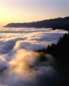
A spectacular meeting of land and sea is the dominant feature of Bureau of Land Management's King Range National Conservation Area (NCA). Mountains seem to thrust straight out of the surf, a precipitous rise rarely surpassed on the continental U.S. coastline. King Peak, the highest point at 4,088 feet, is only 3-miles from the ocean.The King Range NCA encompasses 68,000 acres along 35 miles of California's dramatic north coast. Here, the landscape was too rugged for highway building, forcing State Highway 1 inland. This remote region of mountains and seascapes is known as California's Lost Coast and is accessible only by a few back roads. It is the Nation's first NCA, designated in 1970.
The King Range NCA's Douglas fir-covered peaks attract hikers, hunters, and campers, while the coast beckons to surfers, anglers, beachcombers, and many others. World-class mountain bike trails, and 42,585 acres of coastal wilderness are two of the highlights of this incredibly unique area.
Permits are required year-round for overnight camping in the King Range Wilderness. No permit is required for day-use. Group sizes are no more than 15 persons.
Trailhead entrees for all visitors camping overnight is limited to:
- 60 persons per day May 15 through September 15
- 30 persons per day September 16 through May 14
Visitors planning to camp overnight in the King Range Wilderness will be asked to provide a tentative itinerary; including number of days in the wilderness, entrance trailhead, exit trailhead, and backcountry camp zones. To assist in planning an overnight trip into the King Range Wilderness, take time to review the trailhead descriptions and directions, as well as the camp zone map and zone descriptions.
Are you an organized group? A school group? A BSA Troop? A Meetup group? A commercial outfitter? All organized and commercial groups accessing the King Range Wilderness need a Bureau of Land Management Special Recreation Permit. Permits obtained from Recreation.gov are not permissible for organized and commercial groups. Click here for more information and/or to request a Special Recreation Permit.
For more information or help planning your itinerary, call the King Range Project Office at (707) 986-5400.
Lost Coast Trail Tips: Learn How to Manage Your Waste