
Cherokee Hills Byway
Situated in the foothills of the Ozark Mountains, the Cherokee Hills Byway is a showcase of eastern Oklahoma’s
tremendous diversity. From lush scenery and breathtaking natural beauty to a rich cultural and historical background, the Cherokee Hills Byway is a traveler’s oasis inspiring visitors to delve deeper into the theme and countless opportunities available along the byway.
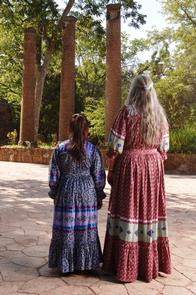
Partake of the culture and history of the Cherokee people as you relive the past of the tragic Trail of Tears, known to the Cherokees as "the trail where they cried." This historical preview is a picture of the Cherokee culture as it
was and is today. See remnants of the proud Cherokee heritage in architecture, museums, and other cultural venues and events, or tour the Cherokee Nation of today and observe how the ancient traditions live on in day-to-day life. This is where the story begins after the Trail of Tears.
The story of the Cherokee people can be heard throughout the byway. It is a story of tragedy and triumph, setbacks and successes. See the beauty of the area with the crystal clear waters of the Scenic Illinois River. Learn why this gorgeous body of water was so important to the lives of the Cherokees as they inhabited their new homeland. The rolling foothills of the Ozark Mountains gives the visitor a heightened visual sense and at the same time imagining how the Cherokees used these same hills, rivers and woodlands to hunt and gather to sustain a lifestyle.
Today, the Cherokee people can be found preserving the history and culture of a proud nation as well as creating a
successful future for generations to come.
RecAreaDirections
Getting to the Byway:
NW Arkansas Airport, AR
*Head east on Tower Drive toward Airport Service Road/Regional Avenue.
*Turn right (south) at Airport Service Road/Regional Avenue.
*Turn left (south) at Airport Blvd/Regional Avenue.
*Turn right (west) at AR-264/Healing Springs Road. Continue to follow AR-264.
*Sharp left (west) at AR-12/AR-264.
*Continue to follow AR-12.
*Turn right (south) at S Collins Road toward SW 1st Street.
*Slight right (west) at AR-264/AR-59/S Gentry Blvd. Continue to follow AR-59.
*Turn right (west) at AR-412/AR-59/AR-68. Continue to follow AR-68.
####Entering Oklahoma####
*Continue on Cherokee Turnpike/US-412, where the byway begins.
Tulsa International Airport, OK
*Head northwest on Airport Blvd/Airport Dr toward N 75th E Ave. Continue to follow Airport Blvd.
*Turn right (southwest) at E Virgin St.
*Turn left (southeast) toward OK-11 E (signs for OK-11 E/I-244 E/Tulsa/Joplin).
*Take the ramp onto OK-11 E.
*Take the exit onto I-244 E/US-412 E toward US-169.
*Merge onto I-44 E.
*Continue on US-412 E (signs for Chouteau) Partial toll road.
*Exit onto Cherokee Turnpike/US-412/US-59.
*Continue to follow US-412, where the byway begins.
Fayetteville, AR
*Take US-71 North, merge on to I-540 North, take exit 72 to US-412 West.
*Continue on US-412 for approximately 25 miles.
*The byway begins at its northern point at US-412 in West Siloam Springs, OK.
Navigating the Byway:
###West Siloam Springs to Kansas###
- The byway's easternmost terminus is at the Oklahoma/Arkansas Border. Drive west on U.S. Highway 59 to Kansas.
###Kansas to Tahlequah###
- Turn south on State Highway 10.
- Turn west on U.S. Highway 62 to Tahlequah.
###Tahlequah to Interstate 40###
- Turn south on U.S. Highway 62.
- Turn southeast on State Highway 82.
- State Highway 82 changes to State Highway 100.
- Turn south on State Highway 10A/100.
- State Highway 100 changes to N. Main Street.
- Turn southeast on U.S. Highway 64.
- Turn south on State Highway 10 to Interstate 40, where the byway ends.
Misc
| Stay Limit | |
| Reservable | false |
| Keywords | |
| Map Link | |
| Contact Phone | |
| Contact Email |
Permits info
Facilities
no data available
