
Coulee Corridor Scenic Byway
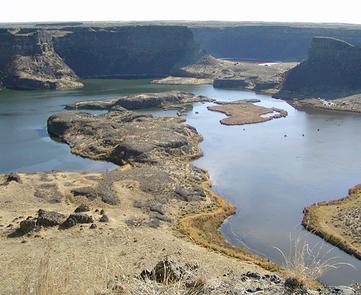
Take a ride on the Coulee Corridor Scenic Byway, an amazing 150-mile road trip revealing the story of the Ice Age floods when vast reservoirs of water flooded and receded from this valley hundreds of times. One of the most unique natural landscapes in the United States, this area was formed as the force of water fought against the strength of basalt rock. The result is a geologist’s mecca.
Experience the ineffable in the landscape as well as world-class recreational opportunities. The Coulee Corridor is the second-most-important birding corridor in the United States. The byway offers recreation for everyone. Between three state parks, a national wildlife refuge, visits to the Grand Coulee Dam and Lake Roosevelt National Recreation Area, or Othello’s Sand Hill Crane festival, you'll find something for the whole family.
Traveler services are clustered within the nine towns along the byway, leaving vast vistas wide open. A National Natural Landmark and a National Historic District, the Coulee Corridor is often selected for car commercials. Consistent grassroots support from every town along the byway and strong partnerships with both the Colville Indian Nation and Washington State Parks have enabled this byway to develop to a high level of maturity. Spend the day roaming the majestic Washington landscape on the Coulee Corridor Scenic Byway.
RecAreaDirections
Getting to the Byway:
###From Seattle, WA### * Drive I-90 east to Moses Lake. * Exit onto WA-17 to enter the byway. ###From Spokane, WA### * Drive I-90 southwest to Moses Lake. * Exit onto WA-17 to enter the byway.
Navigating the Byway:
The Coulee Corridor Scenic Byway runs in a north to south direction along parts of three highway routes -- SR 155, US 2 and SR 17 -- in the heart of north-central Washington.
The northern gateway is in the City of Omak, where SR 155 leaves US 97.
* Travel southeast across the Confederated Tribes of the Colville Reservation, over Disautel Pass, by the Town of Nespelem, and across the Columbia River at the Town of Coulee Dam.
* Cross SR 174 in the Town of Grand Coulee after 52.6 miles.
* Continue south on SR 155 along the shores of Banks Lake for 23.7 miles where SR 155 intersects with US 2.
* The byway turns west on US 2 for 6.2 miles going through the Town of Coulee City and across Dry Falls Dam where it joins SR 17.
* Head south on SR 17 for 21.3 miles where you'll cross SR 28 at the Town of Soap Lake.
* Continue south on SR 17 for 24.5 miles going through the City of Moses Lake and crossing Interstate 90.
* The byway continues south on SR 17 to its southern gateway, the City of Othello, crossing SR 26 in 22.4 miles.
Misc
| Stay Limit | |
| Reservable | false |
| Keywords | |
| Map Link | |
| Contact Phone | |
| Contact Email |
Permits info
Facilities
no data available
