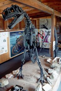
Dinosaur Diamond Prehistoric Highway
The Dinosaur Diamond runs through the best land in the world to learn about dinosaurs. Numerous sites are available to the public where bones and tracks are still visible in the ground. Many museums along the way add to the opportunities to see and learn about dinosaurs.

RecAreaDirections
Getting to the Byway:
Salt Lake City International Airport, UT
* Exit the airport onto I-80 eastbound.
* Turn onto I-15 southbound.
* Continue on I-15 through Salt Lake City, Draper, over the point of the mountain, Lehi, and past Orem and Provo.
* Take US 6 toward Price.
* At the junction of US 191 and US 6 the byway begins. You can turn onto US 191 to proceed on the byway toward Duchesne and Vernal, or continue on US 6 to take the byway through Price and on to Green River and Moab.
Denver, CO
- Get on I-70 west out of Denver.
- Follow I-70 to Fruita/Grand Junction where you will join the byway.
Salt Lake City, UT
* Exit the airport onto I-80 eastbound.
* Take I-80 east just past Kimball Junction.
* Get on US-40 and go southeast to Duchesne where you enter the byway.
Navigating the Byway:
The Dinosaur Diamond Prehistoric Highway travels through two states (Colorado and Utah), creating a loop that resembles a diamond shape. The byway begins in Grand Junction, Colorado, and travels west through the Utah towns of Moab, Green River, Price, and Vernal before crossing back into Colorado to Rangely, Fruita, and back to Grand Junction. The byway can be followed to the north going in a counterclockwise direction, or to the west, going in a clockwise direction.
###Colorado Section###
The Colorado section of the Dinosaur Diamond travels through the western portion of the state.
* Start at the Utah-Colorado border on US-40.
* Turn south onto CO-64 at Dinosaur and continue to Rangely.
* From Rangely, travel south on SR 139 to Loma.
* From Loma, travel east to Fruita on US 6 and Grand
Junction.
* To loop back to the UT section, travel west on I-70 to the
UT/CO border, where this section of the byway ends.
###Utah Section###
####UT/CO Border via I-70 to Moab####
* The Utah Section starts at the UT/CO border on I-70. Go west.
* Take exit 212, the eastern Cisco exit, and turn left over the Interstate.
* A mile and a half west of Cisco is the three-way junction with
UT-128.
*Turn left and head south toward the Colorado River, Castle Valley, and Moab.
* At the intersection with US 191, turn left (south) to reach Moab, UT.
####Moab, UT to Green River, UT####
* Turn right (north) onto US 191 and cross the Colorado River.
* Continue north to Crescent Junction and I-70.
* Take I-70 west past Green River, UT.
####Green River, UT to Price, UT####
* Two miles west of Green River, UT turn north at exit 156 onto US 6/191.
* Head north towards Price, UT, about 60 miles northwest.
####Price, UT to Duchesne, UT####
* From Price, continue north and west on US 6/191 through the town of Helper.
* Four miles north of Helper is where US 6/191 splits. Take the right-hand turn onto US-191 that goes down and over the Price River, the railroad tracks, and around the coal-fired power plant you see there.
* Continue on US-191 44 miles up Willow Creek Canyon, up and over Reservation Ridge with a
pass at just over 9,000 feet above sea level, and down through Indian Canyon to the town of Duchesne, UT in the Uintah Basin.
####Duchesne, UT to Vernal, UT####
* A few blocks after crossing the Strawberry River, there is a stop sign that divides US 191 from US 40.
* Turn right and head east on US 40 through Myton at the Duchesne River bridge and then through Roosevelt.
* US 40 continues on into Vernal ending up on Main Street.
####Vernal, UT to UT/CO Border####
* Take US 40 east for 12 miles to reach Jensen, UT.
* Continue east across the bridge over the Green River.
* Travel 18 miles to UT/CO border where this the Utah section of the byway ends.
Misc
| Stay Limit | |
| Reservable | false |
| Keywords | |
| Map Link | |
| Contact Phone | |
| Contact Email |
Permits info
Facilities
no data available

 CuteCamper
