
Florida Keys Scenic Highway
The southern section of US 1 is part of "the old national road" that started in Maine and traveled down the East Coast to Florida. Its predecessor routes were primitive roads built in the 1880s to connect pineapple farms around old Key Largo to docks where crops were transported to the mainland. Before that, the only way to travel in the Keys was by boat.
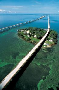
The Florida Keys Scenic Highway travels through some of the nation's most spectacular scenery. While it's not part of an old Bob Hope and Bing Crosby movie, folks in the Florida Keys still describe the stretch of US 1 from Key Largo to Key West as the "Road to Paradise." From the moment you reach the top of Key Largo’s Jewfish Creek Bridge on US 1 traveling south, the feeling of escaping the pressures of daily life by traveling to “the islands” overtakes you. Come experience outstanding natural beauty, world-class fishing and diving, festivals, sunset celebrations, state and national parks, water sports, historic sites, museums, island cuisine, sunshine, tropical atmosphere, rich cultural heritage and friendly people that enjoy the laid-back lifestyle of the Florida Keys.
The Florida Keys are a "melting pot of cultures" and they accommodate the multi-lingual and international guests that frequent the islands. Historically, Bahamian and Cuban influences have been dominant since people from these nearby islands have been traveling to the Keys for hundreds of years. Culture, music, art, architecture and cuisine of the Keys are steeped in these island traditions. Come experience the splendor of this byway, and find a feeling of beauty and relaxation in a one-of-a-kind location found no where else in the world.
RecAreaDirections
Getting to the Byway:
Key West International Airport, FL
* The Key West Airport is located on South Roosevelt Boulevard in the City of Key West. It is approximately 3 miles from the Florida Keys Scenic Highway (FKSH)
(approximately a 5-minute drive).
* From the airport, drive east on South Roosevelt Boulevard until it intersects the FKSH at MM 4.
* From there, either travel northbound on the scenic highway to the upper Keys or southbound into the City of Key West at the south end of the scenic highway.
Miami International Airport, FL
* The Miami International Airport (MIA) is located approximately 60 minutes north of the northern limit of the Florida Keys Scenic Highway.
* When departing MIA, follow the signs south to the Florida’s Turnpike and then to US 1.
* The route from MIA to the Florida Keys is well marked.
Navigating the Byway:
Begin the byway south of Florida City on US-1 as you leave the mainland. Continue on US-1 from Key Largo to Key West.
The byway, also known as the Overseas Highway, is lined with
milemarkers every mile, like most every other highway in America. Awareness of these markers is useful as residents of the Keys refer to them continually. When asking for directions in the Keys, the answer likely will be that the spot being sought is at, just before or just beyond a mile marker number.
The GPS coordinates for the FKSH are as follows: the Northern limit is Latitude: 25 degrees 19.139 and Longitude: 80 degrees 38.722. The Southern limit is Latitude: 24 degrees 32.794 and Longitude: 81 degrees 47.849.
Misc
| Stay Limit | |
| Reservable | false |
| Keywords | |
| Map Link | |
| Contact Phone | |
| Contact Email |
Permits info
Facilities
no data available
