
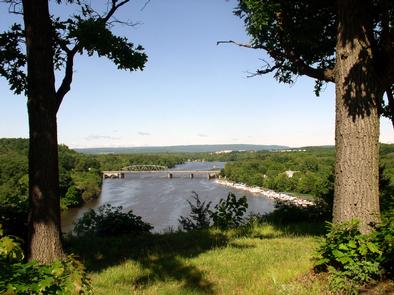
Mohawk Towpath Byway
Visit New York's historic canal system and see the locks and bridges that made canal transport possible for almost two centuries. The Mohawk Towpath Byway links scenic, recreational, and historic resources. Architecture from the 18th and 19th centuries endures, as do the landscape and the perseverance of the canal builders. As you explore, other stories emerge including the area’s natural history, Native American influences on the only water-level route through the Appalachian Mountains, the American Revolution, the role our communities played in the westward expansion of the country and in the Industrial Revolution, the seat of innovation and invention, and family history.
RecAreaDirections
Getting to the Byway:
Albany, NY
* Take I-787 north to Green Island.
* Continue on NY-787 north to New Cortland St in Cohoes where the byway begins.
Navigating the Byway:
The byway begins at the intersection of State Hwy. 32 and 9th St. in Waterford, New York.
From there:
* Drive south on State Hwy. 32/Saratoga Ave to New Cortland Street, about 1.7 miles.
* Drive northwest on New Cortland Street. It becomes North Mohawk Street.
* Drive northwest on North Mohawk Street. It becomes Cohoes-Crescent Road.
* Turn right onto Route 9 and continue for 0.6 miles.
* Turn left onto Crescent/Vischer Ferry Road and continue for 0.1 miles.
* Turn left onto Canal Road and continue for 2.3 miles.
* Turn right onto Clamsteam road and continue for 0.3 miles.
* Turn left onto Riverview Road and continue for four miles.
* Bear left to continue along Riverview road and yield to traffic entering from Vischer Ferry road. Continue for 3.7 miles.
* Continue straight through the stop sign. Riverview Road becomes Saratoga County Route 91. Continue for 1.7 miles.
* Turn left onto State Route 146 and continue for 0.3 miles.
* Turn right onto Aqueduct Road and continue for 2.1 miles. The road will become Van Vranken Ave.
* Bear right at the intersection with Maxon Road and continue for 1.2 miles.
* Turn left onto Erie Boulevard and continue for 1.3 miles to the western terminus of the byway at the intersection of State Street which is State Route 5 and the Revolutionary Byway.
An alternate route from Route 9 in Crescent, Halfmoon (fourth bullet above) returns to Waterford at the intersection of Eighth Street and Route 32.
* Turn right onto Church Hill Road and continue for one mile.
* Continue straight through the stop sign. The road becomes
Saratoga County Route 94. Continue for 0.4 miles.
* Turn right onto Saratoga County Road 96 and continue for 0.2 miles.
* Turn right onto County 97 (Fonda Road) and continue for three miles.
* County 97 (Fonda Road) becomes Washington Ave in the village of Waterford.
* Turn left onto Park Ave.
* Turn right onto Sixth Street and continue for 0.2 miles to the eastern terminus at the intersection of State Route 32.
Misc
| Stay Limit | |
| Reservable | false |
| Keywords | |
| Map Link | |
| Contact Phone | |
| Contact Email |
Permits info
Facilities
no data available
