
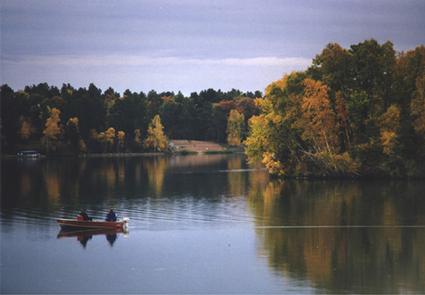
Paul Bunyan Scenic Byway
Like nature's table of contents, the lakes and woods of the Paul Bunyan Scenic Byway are chapters filled with many recreational opportunities and adventures just waiting to be discovered. With the wink and wit of Paul Bunyan lore slipped in for fun, sites and events turn easily into sparkling memories.
RecAreaDirections
Getting to the Byway:
Duluth, MN
* Take I-35 southwest past Cloquet.
* Get on MN-210 and follow it to Crosby.
* Turn north on MN-6 and follow it to County Rd. 11.
* Turn west on County Rd. 11 and follow to its intersection with County Rd. 3 where you enter the byway.
Minneapolis, MN
* Take I-94 northwest to St. Cloud.
* Get on MN-15 going north.
* Merge onto US-10 and go north to Little Falls.
* Take MN-371 to 2 miles north of Pequot Lakes.
* Turn east onto County Rd. 16 and enter the Paul Bunyan Scenic Byway.
Navigating the Byway:
###Loop 1 (South Loop)
* Starting at the south end of the byway at
the intersection of CSAH 11 and Highway 371, travel east on CSAH 11 for 10.7 miles to CSAH 3.
* Turn north on CSAH 3 for 4 miles where it turns
into CSAH 66 at Crosslake.
* Continue north for 3 miles to CSAH 16
intersection and turn west onto 16.
* Follow CSAH 16 for 12.7 miles back to
Highway 371.
* (South on 371 for 2.2 miles returns travelers to the starting point at 11/371 intersection).
* Travel 2.2 miles north on 371 to the next byway loop at the intersection with CSAH 15.
* Highway 371 is not part of the officially designated byway route.
* The route is gapped wherever it joins Highway 371.
###Loop 2 (North Loop)###
* Turn northeast onto CSAH 15, traveling 7.1
miles to CSAH 1.
* At CSAH 1, turn east for 8.1 miles to CSAH 66,
then south for 3.1 miles on 66 and west 12.7 miles on CSAH 16.
* (Because CSAH 16 is part of the South and North Loops it is referred to as the
Spine of the byway.)
* At the intersection of 16 and 371, turn north
on 371 and travel 7.4 miles into Pine River.
* Highway 371 is not
part of the officially designated route.
###Loop 3 (Extension Loop)###
* At the stoplight in Pine River turn
right and follow Barclay Ave through town, across the bridge and then sharply to the right.
* Follow CSAH 1 for 14.1 miles until it
intersects with CSAH 66.
* Take 66 south to the intersection of 16
and 66.
* Go west on 16 for 12.7 miles to return to Highway 371. (This loop can be made into a short version by following CSAH 1 for 6 miles, then turning west onto CSAH 15 for 7.1 miles to the intersection with 371.)
* From the 15/371 intersection it's 6 miles
north on 371 to return to Pine River.
Misc
| Stay Limit | |
| Reservable | false |
| Keywords | |
| Map Link | |
| Contact Phone | |
| Contact Email |
Permits info
Facilities
no data available
