
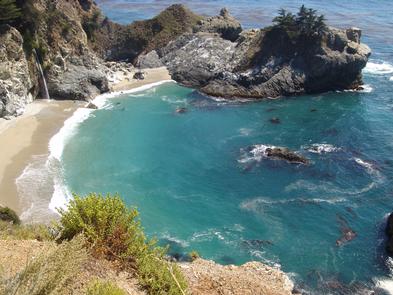
Route 1 - Big Sur Coast Highway
Travel the route that hugs the California coast, providing access to austere, windswept cypress trees, fog-shrouded cliffs and the crashing surf of the Pacific Ocean. Views include rugged canyons, towering redwoods, sea lions, and other marine life.
RecAreaDirections
Getting to the Byway:
Oakland International Airport, CA
* Head southeast on Airport Drive.
* Continue onto 98th Avenue.
* Merge onto I-880 S.
* Take exit 4-B to merge onto US-101 S toward Los Angeles.
* Take the ramp to Monterey/Peninsula.
* Merge onto CA-156 W.
* Continue onto CA-1 S.
* Take exit 399A toward CA-68 W toward Pacific Grove/Pebble Beach.
* Slight left at CA-68 E.
* Take the 1st right onto 17 Mile Drive.
San Francisco International Airport, CA
* Merge onto US-101 south.
* Merge onto CA-156.
* Merge onto CA-1 south.
* The byway begins on CA-1 in the city of Carmel-By-The-Sea.
San Jose International Airport, CA
* Head southeast on Terminal Drive toward Airport Pkwy.
* Continue onto Airport Blvd.
* Continue onto Angelo Way.
* Turn left at Airport Blvd.
* Turn right to merge onto CA-87 S onto I-280/Downtown.
* Take exit 1A for State 85 S toward Gilroy.
* Merge onto CA-85 S.
* Merge onto US-101 S.
* Take the ramp to Monterey/Peninsula.
* Merge onto CA-156 W.
* Continue onto CA-1 S.
* Take exit 399A for CA-68 W toward Pacific Grove/Pebble Beach.
* Slight left at CA-68 E.
* Take the first right onto 17 Mile Dr.
San Francisco, CA
* Get on US-101 south.
* Merge onto CA-156.
* Merge onto CA-1 south.
* The byway begins on CA-1 in the city of Carmel-By-The-Sea.
Navigating the Byway:
* Start at the San Luis Obispo County line, just north of Ragged Point Vista on State Hwy. 1/Cabrillo Hwy.
* Drive north on State Hwy. 1/Cabrillo Hwy. to Ocean Ave in Carmel, CA, where the byway ends.
Misc
| Stay Limit | |
| Reservable | false |
| Keywords | |
| Map Link | |
| Contact Phone | |
| Contact Email |
Permits info
Facilities
no data available
